Footpaths and walks in the Leckhampton Fields
|
|
|
- Carol Miller
- 5 years ago
- Views:
Transcription
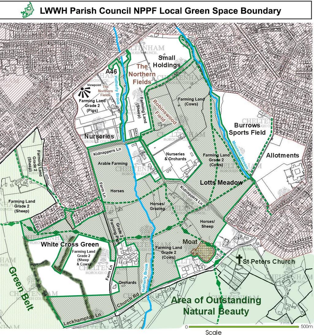
1 APPENDIX 5 Footpaths and walks in the Leckhampton Fields Because of its network of footpaths, the Leckhampton Fields have many different walks. The rich diversity of landscape, hedgerows, trees, streams, ponds, many fields, small holdings, cottages, creates a excellent variety of interest and beauty that changes through the year. Circular walks The Leckhampton Field Circular Walk has several routes, depending on the choice one makes in the network of footpaths between Kidnappers Lane and Farm Lane. All of the routes do however pass through the small holdings and Robinswood Field and it is easiest to describe them by starting from the smallholdings. The walks are described below in an anti-clockwise direction, but can obviously be walked in either direction and the photographs illustrating the walks are similarly in an anticlockwise sequence. Walking in the anticlockwise direction, there are fine views of the Hill across Robinswood Field, along Kidnappers Lane and from the fields of Church Farm. Walking in the clockwise direction there are fine views of Leckhampton Hill in Lotts Meadow and Burrows Field, fields between Kidnappers west of Kidnappers Lane. As well as the public footpaths, there are additional paths all over Lotts Meadow, round the perimeter of Robinswood Field and round the field by the old Leckhampton Cottages (the field south of the three fields marked Horses/Grazing near the middle of the map). The Cheltenham Circular Path crosses these fields and is shown on the map by the Ordnance Survey diamond markings. In the anticlockwise direction and starting from the small holdings, the circular walk follows round the west end of the smallholdings to Robinswood Field and from there to Kidnappers Lane. There is wide grass verge on the west side of Kidnappers Lane and the route follows this to the corner where Kidnappers Lane east. From here, there are two public footpaths, one heading west and the other south. The long circuit takes the path west, crossing Hatherley Brook to reach Farm Lane. Here the route turns left and follows Farm Lane south past a much appreciate pig field on the left. When the route reaches the Cheltenham Circular Path, it turns left (east) across a wild field, crossing Hatherley Brook by an impressive footbridge and then turning right and going south along Hatherley Brook to Church Road. At Church Road the route turns left and follows the road until it reaches St Peter s Church. Here there is another choice to make. The longest circuit continues along Church Road until it reaches the footpath between Moorend Stream and the allotments. A slightly shorter route, turns left at St Peter s and follows the Cheltenham Circular Path northwest to Moat Cottage, where there is an intersection of four paths. Here the route turns right, past Moat Cottage on the right to reach Kidnappers Lane. It crosses Lotts Meadow to the gate at the north end from where the path follows Moorend Stream until it reaches the smallholdings again. Page 1
2 The slightly longer route follows Moorend Stream from the allotment, either via Lotts Meadow or through Burrows Field on the other side of Moorend Stream. There are shorter variants that cut off sections of the long circuit by heading straight back to the four-way footpath intersection at Moat Cottage. The route is clearer following the photographs and descriptions below. One can start also these circular walks also from the car park in Burrows Field, the roads north of Burrows Field, from Church Road, from Farm Lane and from the A46 via the access track through the smallholdings or via the path along Moorend Stream which continue to the A46 (not shown on map). The Leckhampton Fields Circular Path is used by residents from all directions and further afield, including from Charlton Kings and inner Cheltenham. Loop walks There are several loop walks round fields that are particularly used by dog walkers. 1. From Warden Hill and Shurdington Road along track through the small holdings and a loop round Robinswood Field or round Lotts Meadow. 2. Via the Cheltenham Circular Path across Farm Lane into White Cross Green, around these fields and back via the Cheltenham Circular Path. 3. From Burrows Field car park across Burrows Field and Lotts Meadow. 4. A loop around Lotts Meadow from small parking space (2 cars) where the public footpath from Moat Cottage crosses Kidnappers Lane. Footpath maintenance Leckhampton with Warden Hill Parish Council regularly maintains all of the walks on the Leckhampton Fields, cutting back nettles, brambles, tree branches, hedges and other obstructions. Local people also maintain some of the paths of their own accord. Various local volunteers regularly pick up litter along Church Road, Kidnappers Lane and Farm Lane. Views along the Leckhampton Fields Circular Path These photographs follow the route of the circular path as described above starting and ending in the smallholdings. The long circuit is described first that goes to Farm Lane and to Church Road. Three main routes are shown, but as noted earlier the network of footpaths makes it possible to choose a variety of circuits. All routes, however, pass along the footpath through the small holdings, and there is no doubt that this section of the path is greatly loved by many people for its charm, interest, animals and wilderness areas. The photographs below which follow and describe the route of the path show some of its varied rural landscape. The views change with the seasons and the photographs show something of this. Most (37 out of 54) of the photographs were taken on two afternoons in December 2014 for the purpose of this submission. The loop walks on Lotts Meadow, Robinswood Field and White Cross Green are shown in separate annexes with photographs of each of these areas. Page 2
3 Page 3


4 Path through the smallholdings Path through the smallholdings. The northern smallholding are on the right. Page 4


5 One of the northern smallholdings along the Leckhampton Fields Circular Path The access track to the smallholdings. This also provides access to the Leckhampton Fields and the Circular Path from Warden Hill and Shurdington Road. The northern smallholdings are on the left. Page 5

6 Circular Path heading south from the smallholdings into Robinswood Field Following the west hedge of Robinswood Field Page 6

7 Up Kidnappers Lane to the corner where the Lane bears left and the path bears right. At the bend the path bears right heads across the field on the other side of this fence. Page 7

8 To the right is a view of two of the old Leckhampton cottages. The longer circuit heads west across the fields to Farm Lane. The land here has an unusual form of sliding gate. The top slides across and one can then walk through the V. Page 8
9 To the right are stables. To the north there is a view towards Moat Cottage. The shorter version of the circular path run along the hedge on the left and goes straight to Moat cottage. Page 9

10 The longer circuit crosses the main tributary of Hatherley Brook and climbs back to Farm Lane. There are two fields on the map, but the boundary hedge has been removed. Both are owned by GCC and used for horse grazing. Looking back along the path. Hatherley Brook runs along the line of trees. Page 10
11 The circular path follows south along Farm Lane besides a pig field. In the distance one is looking across Hatherley Brook to one of the old cottages. Past the pig field, the Circular Path turns left following onto the Cheltenham Circular Path back to Hatherley Brook. The path runs over a pretty ungrazed field with an bundance of blackberry bushes and grasses. Page 11

12 From the footpath, looking south towards Leckhampton Hill. From the footpath looking north across the field. Page 12
13 From the footpath, looking south with Leckhampton Court Farm on the right. This is an example of the type of recent development that has blended in well. From the path, looking south along the line of Hatherley Brook on the left, marked by the willows. Page 13
 and across the Church Farm fields to Church Road.")
14 After crossing Hatherley Brook by a sturdy footbridge, the route either continues to follow the Cheltenham Circular Path to Moat Cottage, or it turns right and follows Hatherley Brook (just visible on the right in this picture) and across the Church Farm fields to Church Road. Shorter route following the Cheltenham Circular Path to the four-path intersection at Moat Cottage Page 14


15 The longer circuit path follows Hatherley Brook through Church Farm fields to Church Road. This view is looking north Same view in winter Page 15

16 View from the path looking back across the Church Farm land to one of the old cottages. Moat cottage is visible in the centre by the two tall poplars. Same view across Church Farm fields in May Page 16


17 View of Leckhampton Hill across the Church Farm fields. At Church Road, the Leckhampton Fields Circular Path turns left and follow along Church Road to St Peter s Church.. Page 17

18 This is the view the other way, west towards the Crippets junction and Leckhampton Lane. A much longer version of the walks turns left at the junction, up via the Crippets to follow the Cotswold Way National Trail to Leckhampton Hill and back down the Cheltenham Circular Path to St Peter s Church. On the right are old orchards. Old orchard at the corner of Church Road and Farm Lane Page 18


19 Another view in the old orchard. Church Road by St Peter s Church. This path is part of the Cheltenham Circular Walk Page 19


20 St Peter s Church from Church Road. Another view of St Peter s from Church Road Page 20
21 From St Peter s Church one can either continue along Church Road or follow the Cheltenham Circular Path north past the Medieval moat to Moat Cottage. Here the route turns right at the intersection of four path and follows the shorter circuit which is described right at the end. Page 21

22 The longer circuit continues along Church Road past Leckhampton Manor, which dates from about 1315 and is now a Sue Ryder hospice. The fields in the foreground below the Manor are in the Cotswold AONB. Allotments with Leckhampton Primary School in the background Page 22
 or through Lotts Meadow below looking north along")
23 Path along Moorend Stream looking south. The allotments are over the hedge on the left. Moorend streams is the boundary between Burrows Sports ground above (looking south towards Leckhampton Hill) or through Lotts Meadow below looking north along the path with Moorend Stream on the right in the line of willows. Page 23


24 By either route, the Leckhampton Fields Circular Path then continue again along along Moorend Stream and back to the smallholdings. This view is looking south. The stream is to the left and the field north of Lotts Meadow is across the hedge to the right. Path along Moorend Stream Page 24

25 Field north of Lotts Meadow from the Path along Moorend Stream, looking towards the nursery/orchards site Field north of Lotts Meadow from the path along Moorend Stream, looking north towards the boundary hedge of the smallholdings. Page 25


26 Path along Moorend Stream by the smallholdings, looking south. Smallholdings in snow Page 26

27 Northern smallholdings The shorter version of the circular walk heads south from the bend in Kidnapper Lane to Moat Cottage. Page 27


28 On the way, the path passes a small pond, which is probably part of what may be a Medieval feature on the land north of Moat Cottage, shown below. Page 28

29 The Path passes to two old cottages Beside Moat Cottage, four paths cross at the point the walker in red is standing. The path on the right, with two walkers is the Cheltenham Circular Path. This turns right at the intersection and goes to past the Medieval moat to St Peter s Church and then climbs up Leckhampton Hill. At St Peters the Leckhampton Fields Circular Path turns left and joins the route of the longer circuit along Church Road to the footpath along Moorend Stream. Page 29
 to reach Kidnappers Lane.")
30 The alternative at the four path intersection is to take the path to the left, over a stile and to the left of Moat Cottage. The path passes this field on the right and two other old cottages on the left (below) to reach Kidnappers Lane. The route crosses Kidnappers Lane, into Lotts Meadow and across the Meadow to the path along Moorend Stream and back to the smallholdings. Page 30
Bonnie Prince Charlie Walk
 Bonnie Prince Charlie Walk A waymarked route from Ashbourne to Derby to celebrate the 60th anniversary (1995) of the formation of the Ramblers' Association. This route follows the general direction of
There are toilets at Manningtree Station, Flatford (close to the hump back bridge) and in Dedham.
 and in Dedham.") Arriving by Train Main Features of the Walk Outline Route Employs particularly attractive paths, many of which offer impressive views across Dedham Vale. Includes a section along the tidal section of the
Arriving by Train Main Features of the Walk Outline Route Employs particularly attractive paths, many of which offer impressive views across Dedham Vale. Includes a section along the tidal section of the
Husthwaite to Byland Abbey
 Husthwaite to Byland Abbey This walk begins with a loop round the village of Husthwaite and continues towards Coxwold along a disused railway line, which is now a right of way. It passes through Coxwold
Walk Description. Directions
 Title: Saffron Trail: Battlesbridge to Chelmsford Distance: 14¾ miles Time taken: 6 hours Start Point: Outside the Barge Inn, Battlesbridge OS Explorer Map: 175 & 183 Grid Ref.: TQ 780 947 Transport: Rail:-
THE DOG AND DUCK HAREWOODS ESTATE TRAIL. 6 Miles Circular 3 hours. Getting there. Walk Sections
 THE DOG AND DUCK HAREWOODS ESTATE TRAIL Moderate Terrain A 6 mile circular pub walk from the Dog and Duck in Outwood, Surrey. The Dog and Duck is a delightful pub where everyone is made welcome. From walkers
Lincolnshire Limewoods Walks. Woodhall Spa. A circular walk of 13km (8 miles)
") Lincolnshire Limewoods Walks Woodhall Spa A circular walk of 13km (8 miles) Introduction The Lincolnshire Limewoods is an area between Wragby, Bardney and Woodhall Spa. It is a fantastic place to explore
Lincolnshire Limewoods Walks Woodhall Spa A circular walk of 13km (8 miles) Introduction The Lincolnshire Limewoods is an area between Wragby, Bardney and Woodhall Spa. It is a fantastic place to explore
SUMMER WALK 10. The Chairmakers, Worlds End
 SUMMER WALK 10 The Chairmakers, Worlds End Tuesday 10 th June 7.30pm This is a very short walk made so due to the majority of the footpaths in the area around the Chairmakers being overrun with high nettles
Uif!Sfe!Mjpn-!Mpnhepn! bne!dbnnpdl!dibtf-! Tubggpsetijsf
 Uif!Sfe!Mjpn-!Mpnhepn! bne!dbnnpdl!dibtf-! Tubggpsetijsf 7/6!njmft! Djsdvmbs!!!!!!! 4!up!4/6! ipvst Strenuous Terrain Uif!Sfe!Mjpn!jt!b!dmbttjd!wjmmbhf!qvc-!b! hsfbu!qmbdf!up!tbujtgz!zpvs!ivnhfs!bgufs!b!
Launton to Bicester nature footpath improved
 Launton to Bicester nature footpath improved Published 13 July 2012 An attractive rural footpath linking Launton to Bicester has brought back into use by the council's Countryside team. Staff have improved
Walks Around Bishopstone & Hinton Parva
 The Walks: From ½ mile ambles to 8 mile scenic loops Hinton Parva Walks H1 H2 H3 Bishopstone Walks B1 B2 B3 B4 B5 Walk B1: Bishopstone Village, The Dingle (stream) & Pond A short circular village amble
H&T. H O L L O W E L L & T E E T O N P A R I S H C O U N C I L
 H&T. H O L L O W E L L & T E E T O N P A R I S H C O U N C I L Web site: http://www.hollowellandteeton.org.uk/ Email: pc-clerk@hollowellandteeton.org.uk Re: Hollowell & Teeton Parish Council Mowing Areas
Hammer Vale and Linchmere Common
 point your feet on a new path Hammer Vale and Linchmere Common Distance: 9 km=5½ miles or 6 km=3¾ miles easy walking with one steep section Region: Hampshire, West Sussex Author: Botafuego Refreshments:
RILLINGTON TO MALTON by Tania Dickinson
 RILLINGTON TO MALTON by Tania Dickinson This walk takes you from the Vale of Pickering up on to the Wold scarp, before dropping down again through the pretty village of Settrington and joining the Centenary
Dyrham and Hinton Parish Walks
 Dyrham and Hinton Parish Walks A series of five walks in the parish, exploring most of the public footpaths. By John Miller Each walk is described in detail, with a complete map, to provide a handy guide
Walk Description. Directions
 Title: East Hanningfield Distance: 8 miles / 9 miles Time taken: 3-3½ hours Location: 5 miles south east of Chelmsford Parking: Free car park off The Tye, East Hanningfield, next to the primary school
Welsh Newton and Woodland
 Welsh Newton and Woodland This is a 8.2km miles (approx) walk which will take about 2.5 hours at a relaxed and leisurely pace. There are a few hills but no steep inclines. Start at Llangrove bus stop and
Sandilands to Huttoft Bank
 Coastal Country Park Walks Sandilands to Huttoft Bank A CIRCULAR WALK OF 11KM (7 MILES) INTRODUCTION The Lincolnshire Coastal Country Park lies between Sandilands, Chapel St Leonards and Huttoft on the
Lincolnshire Walks. Grainthorpe. Three circular walks of 2 ¾, 9 and 9 ½ km (1 ¾, 5 ½ and 6 miles)
") Lincolnshire Walks Grainthorpe Three circular walks of ¾, 9 and 9 ½ km (1 ¾, ½ and 6 miles) Introduction Explore the coastal marshes, arable hinterland, Louth Navigation canal and the village of Grainthorpe
Lincolnshire Walks Grainthorpe Three circular walks of ¾, 9 and 9 ½ km (1 ¾, ½ and 6 miles) Introduction Explore the coastal marshes, arable hinterland, Louth Navigation canal and the village of Grainthorpe
Route: Skewsby Foulrice Stearsby
 Route: Skewsby Foulrice Stearsby Distance: 7 miles Map: Explorer: 300 Howardian Hills & Malton Start (OS ref): SE625710 Park in the village of Skewsby. Walk east out of the village to the T-Junction and
Lincolnshire Walks. Ancaster. Three cir cular walks of2 3/4,4or 6km (11/3, 21/2 or 33/4 miles)
") Lincolnshire Walks Ancaster Three cir cular walks of2 3/4,4or 6km (11/3, 21/2 or 33/4 miles) Introduction These walks are set in the attractive countryside around the historic town of Ancaster. The town
Lincolnshire Walks Ancaster Three cir cular walks of2 3/4,4or 6km (11/3, 21/2 or 33/4 miles) Introduction These walks are set in the attractive countryside around the historic town of Ancaster. The town
Follow the Lantern Way clockwise from Dursley Town Hall through Cam & Coaley to Uley and back to Dursley (about 14 miles)
") According to the Rev Kilvert's diary of 1873, couples on their way to evening services in winter followed a practical though unusual local tradition: "My Mother says that at Dursley, when ladies and gentlemen
According to the Rev Kilvert's diary of 1873, couples on their way to evening services in winter followed a practical though unusual local tradition: "My Mother says that at Dursley, when ladies and gentlemen
Chapel Point to Anderby Creek
 Coastal Country Park Walks Chapel Point to Anderby Creek A CIRCULAR WALK OF 8.5 OR 6 KM (5.3 OR 3.75 MILES) INTRODUCTION The Lincolnshire Coastal Country Park lies between Sandilands, Chapel St Leonards
NEWLANDS CORNER AND ST MARTHAS
 NEWLANDS CORNER AND ST MARTHAS 10k CIRCULAR ROUTE 2½-3HRS GU4 8SE From Newlands Corner on the North Downs just outside Guildford, you can enjoy one of the most beautiful panoramas of quintessential English
The Hundred Parishes
 The Hundred Parishes Walks from railway stations number 9 6.4 miles (10kms) from Bishop s Stortford to Stansted Mountfitchet Start: Bishop s Stortford station (Grid Reference TL492209) (ample parking and
LOCAL CIRCUIT EM1: EAST MALLING & BARMING HEATH. N 2m ROADS: Significant roads PATHS: Starting direction Barming Longsole Mission Church
 Ditton Church Scott Close LOCAL CIRCUIT EM1: EAST MALLING & BARMING HEATH 6 Community Centre F Open fields (see 'Introductory Notes') 1m 88 Direction label (as in the walk notes) East Malling Church -
Walk 2: doniford to east quantoxhead
 Walk 2: doniford to east quantoxhead Length: 9 ¼ miles / 15km Good For: Difficulty: Moderate Theme: Nature Notes: This walk is tidal - please check tide times before setting off. Dogs are welcome but need
WETHERBY CIRCULAR by Tania Dickinson
 WETHERBY CIRCULAR by Tania Dickinson This walk in lower Wharfedale includes a disused railway line at the beginning and riverside at the end, with parkland, fields, woodland and villages in between. Distance
Although the majority of these walks are around country lanes you should still follow the Country Code:-
 With the update of the Parish Plan was a request for details of any Walks around Pillaton The following pages give several walks that I and my wife have done for many years. Please be aware that NONE OF
Thornton le Dale Walks
 Thornton le Dale Walks A collection of walks in and around the village Thornton le Dale Traders Forum www.visitthorntonledale.co.uk Thornton le Dale Walks Walk 1: Beck Isle Cottage and All Saints Church
This walk description is from happyhiker.co.uk
 This walk description is from happyhiker.co.uk Pendle Hill Walk From Barley Starting point and OS Grid reference Ordnance Survey map Distance Traffic light rating Barley village honesty box car park OS
Thornton le Dale Walks
 Thornton le Dale Walks A collection of circular walks in, and around, the village www.visitthorntonledale.co.uk Thornton-le-Dale Traders Forum and Thornton le Dale Parish Council 1 Thornton le Dale Circular
BALCOMBE AND ARDINGLY RESERVOIR, WEST SUSSEX
 BALCOMBE AND ARDINGLY RESERVOIR, WEST SUSSEX 7 miles Circular 4 hours 080816 Challenging Terrain Hi, I'm Luke and this is my West Sussex Weekends walk It's a 7 mile loop from Balcombe rail station, taking
HARDMOORS 26.2 WHITE HORSE HALF ROUTE DESCRIPTION - 018
 HARDMOORS 26.2 WHITE HORSE HALF ROUTE DESCRIPTION - 018 Follow Cleveland Way, keeping to the left hand path (right path is a bike trail) Ignoring any turnings to the left or right At path junction (after
THE WELLDIGGERS ARMS, HESWORTH AND FITTLEWORTH TRAIL
 THE WELLDIGGERS ARMS, HESWORTH AND FITTLEWORTH TRAIL 5.5 miles Circular 3 hours 041017 Challenging Terrain A 300-year-old pub turned country-inn on the edge of the South Downs National Park, The Welldiggers
Walk 2 Village Hall - The Shippy - Woodhouse Farm - Village Hall
 Walk 2 Village Hall - The Shippy - Woodhouse Farm - Village Hall The walk is approximately 4km (2.5 miles) across fairly flat countryside with about a quarter on country lanes. It should take about 1 hour
Redesdale Arms. A Trio of Walks
 Redesdale Arms A Trio of Walks Welcome to The Redesdale Arms Hotel The award winning 34 bedroom Redesdale Arms Hotel sits at the gateway to the Cotswolds in the High Street of the historic town of Moreton-in-Marsh.
8 Miles Circular 4 hours
 VISIT RYEDALE HELMSLEY AND RICCAL DALE 8 Miles Circular 4 hours 090616 Challenging Terrain An 8 mile (13km) circular walk from the market town of Helmsley in Ryedale. The route heads out across sheep pastures
The Mendip Way. Route Directions and Maps Wells to Frome
 The Mendip Way Route Directions and Maps Wells to Frome Website: www.mendiphillsaonb.org.uk Email: mendip@mendiphillsaonb.org.uk Facebook & Twitter: @MendipHillsAONB Phone: 01761462338 1 Wells to Shepton
For more information and to buy this book click here ISBN: CICERONE. Guides for walkers, trekkers, mountaineers, climbers and cyclists
 For more information and to buy this book click here ISBN: 9781852845377 CICERONE Guides for walkers, trekkers, mountaineers, climbers and cyclists www.cicerone.co.uk WALK 5 Ouston and Urpeth Distance
Walk NOC 03 Location: Llyn y Fan (the lake) and Fan Brycheinog (the mountain) off Trecastle Road
 and Fan Brycheinog (the mountain) off Trecastle Road") 8 Walk NOC 03 Location: Llyn y Fan (the lake) and Fan Brycheinog (the mountain) off Trecastle Road Directions: Distance (miles): Time (hours): Length of Walk: Turn right out of the castle, take first left
8 Walk NOC 03 Location: Llyn y Fan (the lake) and Fan Brycheinog (the mountain) off Trecastle Road Directions: Distance (miles): Time (hours): Length of Walk: Turn right out of the castle, take first left
LDWA SOUTH DOWNS MARATHON
 AHD ahead SDW South Downs Way BL/BR bear left/bear right TL/TR turn left/turn right SP signpost/fingerpost X cross LEG 1 - EAST DEAN to WP1 NORTON GR 470019. Open 1030 to 1300. 9.6 miles. 1.1 From village
Poundgate and The Hurstwood
 point your feet on a new path Poundgate and The Hurstwood Distance: 11 km=7 miles Region: East Sussex Author: Stivaletti Refreshments: High Hurstwood easy walking Date written: 24-jul-2016 Last update:
Danbury Words and pictures by Laurie Page of the Public Rights of Way team at Essex County Council.
 Danbury Words and pictures by Laurie Page of the Public Rights of Way team at Essex County Council. An undulating walk from Danbury village to the bluebells at the National Trust property of Blakes Wood.
How to get there. Respect - Protect - Enjoy
 How to get there Driving: Postcode is RG9 5PF and there is a car park just across from the pub. Nearest station: Henley-on-Thames station is 5.6 miles away. We re delighted to present three circular walks
10 Miles Circular 5 hours
 VISIT RYEDALE PICKERING AND CAWTHORN CAMPS 10 Miles Circular 5 hours Moderate Terrain 120616 A 10 mile (16km) there and back walk from the market town of Pickering in Ryedale. The route heads north through
Harlington - Sharpenhoe - Pulloxhill
 Harlington - Sharpenhoe - Pulloxhill ID: 3676, Distance: 8 miles, Height gain: 140 Metres, Map: Explorer 193 Luton & Stevenage, Contributor: Dennis Jeanes Duration: 3 Hours 27 Mins Features Church,Great
LDWA SOUTH DOWNS MARATHON 13 th MAY 2018
 AHD ahead SDW South Downs Way BL/BR bear left/bear right TL/TR turn left/turn right X cross LEG 1 - EAST DEAN to WP1 NORTON GR 470019. Open 1030 to 1300. 9.7 miles. 1.1 From village hall TL and walk to
9.5 km Circular 3 hours
 RANMORE CIRCULAR A 6 mile (9.5km) circular walk from Boxhill and Westhumble Station in the village of Westhumble, passing through part of the Polesden Lacey Estate, Ranmore Common and Denbies Vineyard.
No. 1 By River Ribble & Brungerley Park 3¼ Miles,
 RVRNEWS 102 No. 1 By River Ribble & Brungerley Park 3¼ Miles, Approx 2 Hours This walk starts at the gate on platform 2 of Clitheroe station. Leaving the station turn left making towards Kirkmoor Rd and
TOCKENHAM. Walks for Healthy Living. The Countryside Code (October 2016) Respect other people:
 Respect other people:") The Countryside Code (October 2016) TOCKENHAM Respect other people: consider the local community and other people enjoying the outdoors leave gates and property as you find them and follow paths unless
The Countryside Code (October 2016) TOCKENHAM Respect other people: consider the local community and other people enjoying the outdoors leave gates and property as you find them and follow paths unless
Visual impact assessment viewpoint analysis
 Visual impact assessment viewpoint analysis 1 Introduction In this section we analyse the most important viewpoints affected by this development. In each viewpoint where it is relevant we have cross referred
EAST GRINSTEAD AND THE HIGH WEALD, WEST SUSSEX
 EAST GRINSTEAD AND THE HIGH WEALD, WEST SUSSEX 7 miles Circular 3.5 hours 301015 Challenging Terrain Hi, I'm Tom and this is my West Sussex Weekends walk. I live and work in London but often head out of
Shepherdswell - Dover
 Shepherdswell - Dover The North Downs Way > Shepherdswell to Dover Introduction This part of the path is slightly different in character from most other parts of the path since it spends much of the time
9.5 km Circular 3 hours
 MEDIEVAL WAVERLEY Challenging Terrain A 6 mile (9.5km) undulating circular walk from Tilford village passing close to The Sands village and the historic ruins of Waverley Abbey. From the top of Crooksbury
THE PONTON PLOD - 27 MILE ROUTE
 THE PONTON PLOD - 27 MILE ROUTE Emergency Phone Number 07771 813514 Abbreviations: BW Bridleway X Cross immd immediately FP Footpath TL Turn left L Left thro through KG Kissing Gate TR Turn right R Right
Cilgerran Wildlife Park Circular Walk
 Walking embrokeshire Cilgerran Wildlife ark Circular Walk It s good to walk, so why not step out and sample some of the walks your neighbourhood has to offer. This pleasant and interesting walk which starts
A circular walk of or km (2 1 4 or miles)
") Grantham A circular walk of 3 3 4 or 5 3 4 km (2 1 4 or 3 1 2 miles) Introduction This relatively short circular walk, which starts in the middle of Grantham, offers plenty of variety. The route takes
Grantham A circular walk of 3 3 4 or 5 3 4 km (2 1 4 or 3 1 2 miles) Introduction This relatively short circular walk, which starts in the middle of Grantham, offers plenty of variety. The route takes
Outwood: oaks, buttercups and windmill
 point your feet on a new path Outwood: oaks, buttercups and windmill Distance: 9 km=5½ miles Region: Surrey Author: Schwebefuss Refreshments: Outwood easy walking Date written: 23-may-2014 Last update:
Bakewell Club Site - Robin Hood's Stride
 Bakewell Club Site - Robin Hood's Stride Camping and Caravanning Route Summary A circular walk with fabulous views winding it's way through the beautiful White Peak scenery. Points of interest include
Tideswell to Castleton
 Tideswell to Castleton 1 Walk summary Length: 14 km, 8.5 miles Maps: OS Explorer OL1 The Peak District - Dark Peak Area, OS Explorer OL24 The Peak District - White Peak Area, OS Landranger 110 Sheffield
NETTLESTEAD & YALDING
 NETTLESTEAD & YALDING ULL CIRCUIT - Sheet 1 (first and last sections) Open fields (see 'Introductory Notes') 88 Direction label (as in the walk notes) ROADS: 81 10m Significant roads Redhill arm North
A mainly flat walk along the Peak Forest Canal to Castle Hill and returning along the River Tame via Hulmes Wood and Haughton Dale.
 Walk 9 Haughton Green, Peak Forest Canal, Castle Hill, Hulmes Wood, River Tame, Haughton Dale Circular Miles: 3.9 Time: 1 Hour 30 Minutes Grade: Easy To Moderate Starting Point: Junction Of Gibraltar Lane/Newport
Pluckley Circular. The Low Weald of Kent and The Darling Buds of May. Features. Walk options. Transport
 Main walk last checked Extension last checked 25 April 2017 25 April 2017 Current status Document last updated: 12 May 2017 This document and information herein are copyrighted to Saturday Walkers Club.
The North Pennines from near Langwathby
 3.6 Langwathby to Armathwaite Map panel?? Distance 12.7 miles (20.5 km) Terrain farm, woodland and riverside paths; some potentially muddy tracks; a few short sections of road Grade gently undulating Food
Dorridge & District Residents Association A Walk Along The Green Belt From Dorridge to Catherine-de-Barnes
 Dorridge & District Residents Association A Walk Along The Green Belt From Dorridge to Carine-de-Barnes The starting section of this walk through open fields would be destroyed by building of motorway
Countryside Walks. 1) Highclere Park Public Walk.
 Highclere Park Public Walk.") 1) Highclere Park Public Walk. Access: From Highclere Estate Main Entrance at Whitway, please note there is no parking on site or access for vehicles. Open: Throughout the year. Description: This footpath
1) Highclere Park Public Walk. Access: From Highclere Estate Main Entrance at Whitway, please note there is no parking on site or access for vehicles. Open: Throughout the year. Description: This footpath
The Alice Lisle Walking Guide
 The Alice Lisle Walking Guide Using some local knowledge we have been able to design some great walks starting and finishing at the Alice Lisle. If you re planning a group walk, please get in contact with
Maps The maps provided are a guide and are not to scale. Please use OS Explorer Map 120 (Chichester).
.") A Walker s Guide - Chichester Harbour Useful Information Directions All the walks were tested in 2013. Please note, however, that some footpaths may be diverted and buildings such as pubs may have changed
A Walker s Guide - Chichester Harbour Useful Information Directions All the walks were tested in 2013. Please note, however, that some footpaths may be diverted and buildings such as pubs may have changed
Distance: 10 km=6½ miles or 4 km=2½ miles
 point your feet on a new path Old Heathfield Distance: 10 km=6½ miles or 4 km=2½ miles Region: East Sussex Author: Stivaletti Refreshments: Warbleton, Vines Cross, Old Heathfield easy walking Date written:
Approximate distance: 10 miles For this walk we ve included OS grid references should you wish to use them. Start. End
 Approximate distance: 10 miles For this walk we ve included OS grid references should you wish to use them. 2 3 Start End 1 N W E S Reproduced by permission of Ordnance Survey on behalf of HMSO. Crown
Fertile farms in the heart of Kent
 55 55 Fertile farms in the heart of Kent A bright sunny day is perfect for enjoying the rich and fertile Kent countryside and outstanding views across the valley of the Great Stour to the North Downs.
Green Man Ultra Route Directions 2018
 Green Man Ultra Route Directions 2018 Start-CP1 (9 miles) Community Forest Path (CFP) Frome Valley Way (FVW) From the starting line cross the playing fields diagonally to the metal gates in the hedge lined
Hever to Ashurst walk
 Saturday Walkers Club www.walkingclub.org.uk Hever to Ashurst walk A surprisingly remote part of the High Weald on the Kent/East Sussex border Length OS Maps Toughness Features Walk Options Main Walk:
AMAZING WALKS RIGHT ON YOUR DOORSTEP AT WALLOPS WOOD COTTAGES!
 Wallops Wood Cottages Sheardley Lane, Droxford, Hampshire, SO32 3QY emma@wallopswoodcottages.co.uk T: 01489 878888 Sign-up to our NEWSLETTER for special offers and news. You can also follow us on social
Walk: NOC 08 Location: Cym Glyn near Brecon
 33 Walk: NOC 08 Location: Cym Glyn near Brecon Directions: Not easy to find at all. Go to Libanus, then head towards Brecon on the A470. Take minor C road single track lane first right as you come out
Masson Hill. Walk. Approximately 4 km. Moderate Walk Begins from Matlock Railway Station
 Masson Hill Walk Approximately 4 km Moderate Walk Begins from Matlock Railway Station TOWN WALKS Masson Hill walk is approx. 4 km. It can be walked in a couple of hours or so. Enjoy your walk and the beautiful
Distance: 9½ km=5¾ miles moderate walking or two walks of 4¼ km=2¾ miles and 6½ km=4 miles
 point your feet on a new path White Hill, Headley Distance: 9½ km=5¾ miles moderate walking or two walks of 4¼ km=2¾ miles and 6½ km=4 miles Region: Surrey Author: Fusszweig Refreshments: Headley Date
WANBOROUGH PARISH COUNCIL
 1 WANBOROUGH PARISH COUNCIL Minutes of the meeting of Wanborough Parish Council held on 18 th December 2017 in Wanborough Village Hall, High Street, Wanborough at 19.30. PRESENT: Mr C Offer (Chairman),
Chipstead to Kingswood walk
 Saturday Walkers Club www.walkingclub.org.uk Chipstead to Kingswood walk Ancient woodland, open downs and farmland in London's Green Belt Length OS Map Toughness Features Main Walk: 15½ km (9.6 miles).
& r al. Two circular walks of 8 km (5 miles) wal k
 wal k") & Ru r al Two circular walks of 8 km (5 miles) s ford Riv m a t S er wal k Introduction Stamford is noted as being one of the finest stone towns in the country. The stone being local limestone and Collyweston
& Ru r al Two circular walks of 8 km (5 miles) s ford Riv m a t S er wal k Introduction Stamford is noted as being one of the finest stone towns in the country. The stone being local limestone and Collyweston
How to get there. Respect - Protect - Enjoy
 How to get there Driving: Postcode is RG9 3DG and there is a carpark just across from the pub. Nearest station: Henley-on-Thames station is 5.6 miles away. We re delighted to present three circular walks
ST. AGNES. you cannot put a time limit on beauty.
 ST. AGNES CIRCULAR WALKS AROUND There are many enjoyable and picturesque walks around St. Agnes most are signposted and are featured on the St. Agnes Mini-guide map. Because most of our footpaths are in
t ie s Wal k A circular walk of 7 or 91 2 km (41 2 or 6 miles)
") ford Fou m a t S r Co un t ie s Wal k A circular walk of 7 or 91 2 km (41 2 or 6 miles) Introduction This walk is set in attractive countryside on the edge of Stamford in the south-west corner of Lincolnshire.
ford Fou m a t S r Co un t ie s Wal k A circular walk of 7 or 91 2 km (41 2 or 6 miles) Introduction This walk is set in attractive countryside on the edge of Stamford in the south-west corner of Lincolnshire.
s between Andrew Selous MP, Mr. Alistair Moffitt and Central Bedfordshire Council
 Appendix D E-mails between Andrew Selous MP, Mr. Alistair Moffitt and Central Bedfordshire Council Andrew Selous MP query No.2 (23 rd June 2015) From: David Leverington Sent: 17 July 2015 11:07 To: Andrew
A Walk around Holmes Chapel starting & finishing at Holmes Chapel Railway Station. by Tony & Lindsay Wright (2016)
") A Walk around Holmes Chapel starting & finishing at Holmes Chapel Railway Station. by Tony & Lindsay Wright (2016) Introduction Holmes Chapel Railway Station is on the Crewe to Manchester line. The station
A Walk around Holmes Chapel starting & finishing at Holmes Chapel Railway Station. by Tony & Lindsay Wright (2016) Introduction Holmes Chapel Railway Station is on the Crewe to Manchester line. The station
Proposed Development by Cala Homes in Dollicott - Report o n Roads and Traffic
 Proposed Development by Cala Homes in Dollicott - Report o n Roads and Traffic Dolicott Development - Traffic report v1.0 compressed.docx Page 1 of 10 Proposed Development by Cala Homes in Dollicott Report
Chichester Harbour. A Walker s Guide
 A Walker s Guide - Chichester Harbour Chichester Harbour A Walker s Guide Chichester Harbour is an Area of Outstanding Natural Beauty on the south coast of Britain. Virtually flat with far reaching sea
Sweetwater and the Holy Well Witley Station, Hambledon, Chiddingfold
 point your feet on a new path Sweetwater and the Holy Well Witley Station, Hambledon, Chiddingfold Distance: 7½ km= miles Region: Surrey Author: Schwebefuss Refreshments: Hambledon, Chiddingfold easy walking
Where did it all go wrong, George?
 Where did it all go wrong, George? Those readers of a certain age will recognise the above quotation. Uttered by the waiter on room service, as he entered George Best s hotel bedroom, to see him in bed
Distance: 14 km=8½ miles or 7 km=4½ miles easy-to-moderate walking
 point your feet on a new path Normandy Distance: 14 km=8½ miles or 7 km=4½ miles easy-to-moderate walking Region: Surrey Author: Botafuego Refreshments: Pirbright, Ash date written: 20-feb-2012 date revised:
6.5 km Circular 2 hours
 REIGATE MILLS AND PILLBOXES A 4 mile (6.5km) enjoyable circular walk from Reigate Heath, passing Reigate Heath windmill, Wonham Mill and pillboxes built during the Second World War. 6.5 km Circular 2 hours
Walk 2: Beamsley Beacon and Bolton Abbey
 Walk 2: Beamsley Beacon and Bolton Abbey Start and Finish: The Memorial Hall, Main Street, Addingham, LS29 0LZ, SE 079 497 The shortest walk is about 5½ miles (8.8km) The medium Walk is about 8¼ miles
Walk 7: Watchet to washford
 Walk 7: Watchet to washford Length: Moderate - 7.5 miles / 12 km Good For: Theme: History Duration: 2-3 hours depending on speed of walking Notes: This is a moderate to difficult walk in places, with steps,
5 Miles Circular 2.5 hours
 VISIT RYEDALE KIRKBYMOORSIDE AND ST GREGORY S MINSTER Challenging Terrain A 5 mile (8 km) circular walk from the market town of Kirkbymoorside in Ryedale. The route heads west through open fields and pastures,
Slindon Folly - South Downs, West Sussex
 Slindon Folly - South Downs, West Sussex Starts at Park road-side near entrance to Slindon College 2 hours 15 minutes 4.5miles 7.2km Easy ID: 0.1598 Developed by: Chris Mumford Checked by: Rockpit www.ramblersroutes.org
Corkagh Park Maths Trail
 Open your Corkagh Park Maths Trail In association with: This trail begins at the noticeboard at the entrance near the St John s Wood car parks in Corkagh Park The producers of this Maths Trail accept no
Saltash, Cornwall - Railways, Rivers & Castles
 Saltash, Cornwall - Railways, Rivers & Castles Starts at St Stephen's Church, Saltash, Cornwall 2 hours 45 minutes 5.5miles 8.9km Easy ID: 0.2532 Developed by: Peter Clements Checked by: Kevin Connor www.ramblersroutes.org
Bix and the Assendons
 point your feet on a new path Bix and the Assendons Distance: 8½ km=5½ miles Region: Chilterns Author: Phegophilos Refreshments: Lower and Middle Assendon Map: Explorer 171 (Chiltern Hills West) hopefully
10 km Circular 3 hours
 FRIMLEY AND FRIMLEY GREEN 10 km Circular 3 hours Easy Terrain 250716 A 10km (6 mile) circular walk exploring the canal towpath, riverside path, woodland, heath and small settlements around Frimley in Surrey.
Hitchin Nomads Cycling Club
 Hitchin Nomads Cycling Club Risk Assessment of Course Course Identification 1U/10 10 Miles - Southill / Old / Warden / Ireland Circuit Reviewed By Nick Hickman Reviewed On 13/01/2018 Course Details START