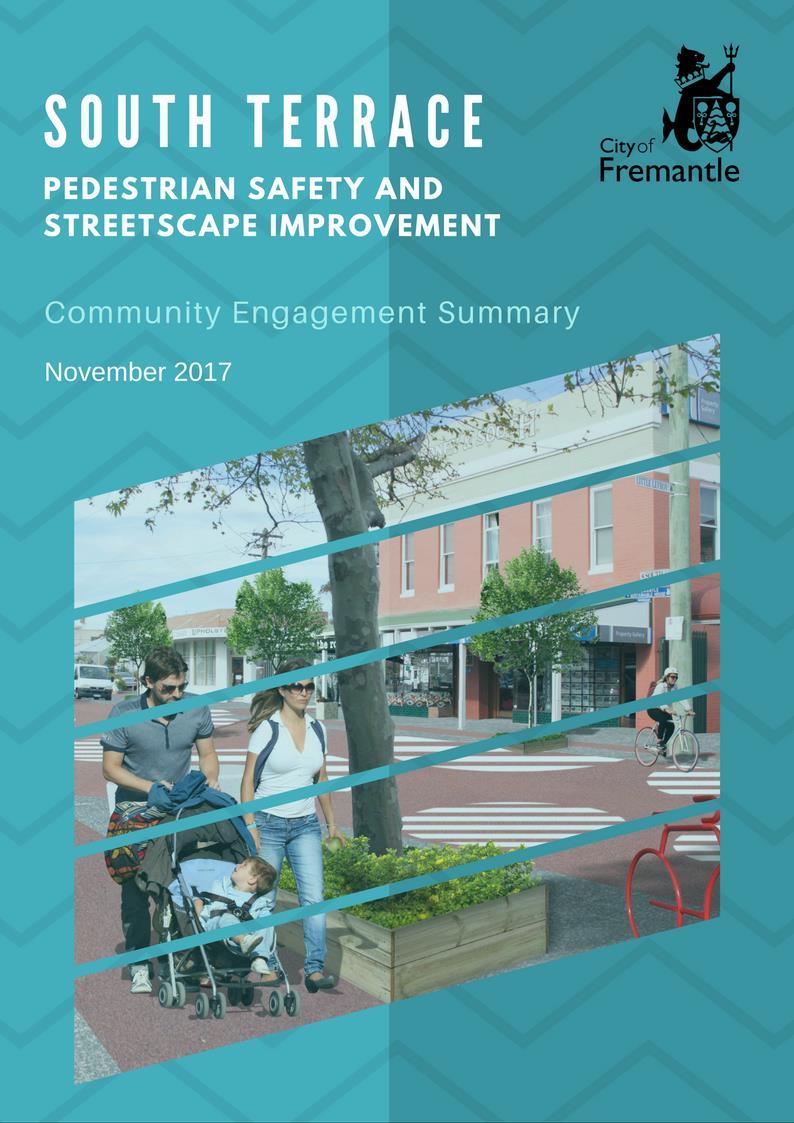
South Terrace Pedestrian Safety and Streetscape Improvement: Community Engagement Summary
|
|
|
- Sheena Paul
- 5 years ago
- Views:
Transcription
1
2 SUMMARY This report provides a summary of the results of the City of Fremantle s community engagement on the proposed traffic and streetscape improvements to South Terrace, between Sydney Street and Little Lefroy Lane, which was conducted in October and November Key findings include: 72.6% of respondents support the proposed changes, with 53.8% indicating they strongly support the changes and a further 18.8% supportive of most changes. The proposal to improve the streetscape was the most supported change, with over 90% of respondents answering positively to the proposed new paving, street furniture, trees and planting. The proposal to reduce the carriageway to a trafficable width of 7 metres is the least supported change. While 58.2 % of respondents support narrowing the road to make it easier for people to cross the street safely, 22.2 % felt this would create more dangerous conditions for cyclists. The need for South Terrace to be calmed from South Street to Douro Road was mentioned by numerous respondents, along with the need to protect the interests of people living in the side streets. A plan for the area bounded by South Street, Douro Road, Marine Terrace and Hampton Road was suggested, following concerns that the proposed treatment at Little Lefroy and South Terrace will create traffic problems elsewhere. The need for a cycle lane on South Terrace between South Street and Douro Road was frequently mentioned, along with a desire to see similar treatments implemented at other nodes in this section. 1
 received 205 views.")
3 Engagement Outcomes ENGAGEMENT SNAPSHOT Participation Outcomes Facebook reactions Unique visits to My Say Freo INFORM Views of FAQs Attended community info session Survey responses ENGAGE Concept plan comments Over the duration of the engagement, the project page on My Say Freo attracted 769 unique visitors. The additional project information (FAQs) received 205 views. Through My Say Freo, participants were able to complete a survey. A total of 98 surveys were logged through My Say Freo and a further 19 physical surveys were received following a community information session at The Meeting Place Who Participated 68.4% 27.3% 2.5% 1.7% South Fremantle residents Visitors Business owners Local workers 2
4 Number of respondents ENGAGEMENT OUTCOMES Level of support for proposed traffic treatment Just over half of the respondents (53.8%) (N=117) strongly support all changes proposed to slow traffic and improve the streetscape. A further 18.8% of respondents support most changes, stating that they would welcome changes to the traffic conditions to make crossing the road safer and easier and improvements to make the street more vibrant and pedestrian friendly but had reservations about the stencil markings confusing drivers and pedestrians, or wanted the treatment applied over a larger section of South Terrace. 11.1% of the respondents support some change. Many of these respondents said they were they were concerned about the safety of cyclists and would like the design to include a dedicated bike lane. 10.2% of the respondents indicated that they do not support most changes and 6.0% do not support any changes, because they believe it will add to congestion on South Terrace, do not see the need to change anything or think the project has limited value and benefit to improving pedestrian safety. Figure 1: How supportive are you of the proposed changes overall? Strongly support all changes Support most changes Support some changes but not all Do not support most changes Do not support any changes at all 3
5 Table 1: Rationale for level of support - sample responses Support Some support Don t support Currently, it's extremely difficult and dangerous crossing South Terrace. Any measures to encourage drivers to slow down are welcome I'm supportive of any changes that make the roads safer for my family. Further, these plans seem to encourage a vibrant, outdoor, alfresco and pedestrian friendly atmosphere which as a Fremantle resident, I look forward to enjoying even more. I use a mobility scooter and on weekends even crossing Little Lefroy at South Terrace can be problematic. The changes would make the area more people friendly, create a stronger community vibe, as well as increase I ride both by myself and with my children in South Fremantle but do not ride in this area with my kids as the road is too busy and unpredictable and it is not safe on the footpaths. Nothing in the plan makes it any safer on the road or on the footpath for cyclists and yet again it is a plan where cyclists don't appear to negotiate intersections as the lane just disappears. Cycling on South Terrace is already dangerous and shrinking the carriage way will only make this issue worse especially if bus routes are not change and traffic volume not reduced. While these kind of raised 'shared zones' are nice in principle my experience of the shared section of South Terrace in central Fremantle is that pedestrians and cyclists, as the more vulnerable within this shared arrangement, end up giving way to cars I think this is likely to be a costly exercise where there is a limited benefit - for most of these changes. Several temporary parklets installed by the relevant food and beverage venues would deliver a much greater benefit. Providing substantial improvements to the medians would be much better at improving crossing safety. The area is not broken. The area is popular. The main problem is parking and every idea suggested subtracts parking without giving any insight into how parking will be dealt with. It s absurd to not acknowledge that the area is already very popular without meaningless intervention. If the City wants the traffic to slow install cross walks and drop the speed limit to 40 as they do in popular Sydney high streets. South Terrace does need to be calmed from South Street to Douro Road, but southbound traffic needs to directed onto Hampton Road (mainly) and Marine Terrace (less so) at South Street. Northbound traffic needs to be 4
6 safety for pedestrians. I would like to see the local businesses flourish, as this adds to the great feel that South Freo has. Already people from other suburbs travel here, if the strip is increased and traffic slowed/reduced, it will make South Freo more attractive to visitors, which in turn helps the business and employment. rather than the other way around. As a parent, although cars may slow down on this raised section of road they will not stop for pedestrians in the same way as with a pedestrian crossing. In summer and on weekends the steady stream of car traffic makes it difficult, even for an adult, to judge when to cross. When the road is made narrower this will mean there is no traffic island or marking in the middle for a pedestrian to pause, thus in order to cross pedestrians will need to have a gap in traffic coming from both directions. Why not incorporate a pedestrian crossing into the design? This idea is perfect if done all the way along South Terrace. Speeding cars and cutthrough traffic are king at the moment. And speed humps are only helpful if they cross the entire road as traffic continually zigzag around the current arrangement making it very dangerous for pedestrians expecting that the cars will slowdown. kept on Hampton Road till South Street. As part of any plan you need to protect the interests of people living in the side streets around this area by making sure that the reduction of traffic on South Terrace does not increase traffic flows in our suburban streets. Maybe the judicious use of one way streets, dead-ending other streets needs to be considered. I cannot support any plans for the area as described unless a master plan for the whole 'block' bounded by South street, Douro Road, Marine Terrace and Hampton Road is developed. Creating a 'pretty space' at Little Lefroy and South Terrace will only create nuisance traffic elsewhere. We live and use the area. Parking is a nightmare. My driveway is often blocked by patrons. The footpath can do with upgrade and some cycle lanes but perhaps pedestrians need to look before crossing. Please don t wreck the vibe like you did Fremantle. It s nice because it s still the suburbs and if you do too much everyone will avoid like Fremantle. 5
7 Number of respondetns Responses to specific elements of the proposed traffic treatment Proposal 1: Reduce the width of the carriageway Support Have some concerns about narrowing the carriageway Opposed to narrowing the carriageway Don't know Figure 2 Most respondents (58.2%) (N=98) support narrowing the carriageway. Most people who responded positively said it would to help slow down traffic and make them feel safer crossing the road. People with young children, people who use a mobility scooter and business owners, welcomed the idea. Respondents who had some concerns about with reducing the width of the road (22.4%) were mainly concerned about the impact on the safety of cyclists. Parking was also raised as a concern, though less frequently than the need to allow sufficient room for cyclists. Of the 17 respondents who opposed reducing the carriageway, 7 preferred to keep the street as it currently is, 4 said it would make it more difficult for them to drive in this section of South Terrace, 3 felt it would create dangerous traffic conditions and 3 did not believe the treatment would create a safer pedestrian environment. As a motorist and also a cyclist my main concern comes from visibility when turning out of Sydney Street (or Jenkins Street) onto South Terrace. However, my main concern is cycling. Motorists are supposed to leave a minimum of a metre when they pass a cyclist, narrowing the road I feel will make it more dangerous for cyclists, as cars try to squeeze past. 6
8 Number of respondents Proposal 2: Install a raised platform, surfaced with red asphalt and stencil markings Support installing a raised platform Have some concerns or other suggestions Figure 3 Opposed to the idea of a raised platform As shown in Figure 3, the proposal to install a raised platform received very high support (78%) (N=82). Respondents who were opposed to the idea (12.2%) were largely opposed to the proposed node treatment in general, and restated their disapproval. Concerned respondents (9.8%) were mostly unconvinced by the stencil markings and suggested the design shown in the concept images would be confusing for both pedestrians and drivers because of their likeness to a zebra crossing. Further, it was suggested they may cause accidents because each thinks they have right of way. It should be noted that the respondents expressing concern about the proposed stencil markings were supportive of slowing traffic, and suggested adjusting the proposed stencil markings to a standard zebra crossing or a design to fit the 'feel of South Freo. Installing a raised platform in the whole area should send a signal to drivers to slow down. I was thrilled to read of the intention to surface the area in red asphalt. I have seen it in various places. It delineates an area, raises its quality, and lifts the spirits psychologically. I suffer from glare so I would loathe the idea of just concrete which is ugly, increasingly whiter in use, more glary, and depressing. I do not know the purpose of the white stencil markings but anything to signify a pedestrian area and slow traffic is welcome. 7
9 Number of respondents Proposal 3: Widen the footpath 53 I want a greater emphasis on pedestrians (and bicycles) for this section of South Fremantle, and for traffic to be slowed. Currently, South Terrace is a thoroughfare around which pedestrians have to navigate. It would be good to reverse the psychology and widening the footpath will achieve this Support widening footpath Have some concerns about widening the footpath Oppose widening footpath Neutral Figure % (N = 81) of respondents like the idea of widening the footpath to create more space for pedestrians. Numerous people said the footpath is currently too narrow to accommodate pedestrians, dogs, prams, small children, cyclists and alfresco eating areas. Defining footpath and alfresco dining areas was also supported to allow pedestrian access without the need to step out into the roadway, making it safer for all, and particularly those using mobility aids. Respondents with concerns (16%) said they would rather see some traffic islands to help pedestrian cross the street or restated their concerns about the impact of narrowing the road on the safety of cyclists and identified the need for a bike lane. Some concerned respondents said they would prefer a bike lane over a wider footpath. Respondents opposed to the proposal (13.6%) felt the footpath was wide enough already or would impact cyclists and parking. I personally think the footpath is wide enough, but the advertising boards make it cluttered. Do we want South Terrace to look like South Street? 8
10 Number of respondents Proposal 4: Add new paving, street furniture, trees and planters. 69 Definitely need more trees and shade cover. South Terrace can be punishingly hot on sunny days. Support streetscape improvements 6 Don't support streetscape improvements 2 Other Figure 5 This was the most supported proposal, with 90.8% of the respondents (N = 76) commenting favourably on improved amenity. Shade trees were widely commended. Some respondents opposed to the proposal (13.6%) felt the footpath was wide enough already. Others preferred trees be lined down the middle of the street to limit impact on cyclists and parking. Some of the respondents opposed to streetscape improvements considered new paving a waste of money. The trees can go in the existing footpath and does not require extra planter boxes on the road which will impact cyclists and parking. As a pedestrian and customer of local business I ll appreciate the improved amenity. It ll be a more attractive area to spend time in. I regularly visit at least 3 of the businesses in this Lefroy Lane to Sydney Street area. I ll feel more inclined to spend time there rather than getting in and out as quickly as possible. 9
11 Number of respondents Proposal 5: Increase the alfresco dining area 64 It's nice to see people sitting out the front of cafes. It will further attract people who will see it from their slow car speed. 6 9 Support more alfresco area Have some concerns about allowing more alfresco area Figure 6 Do not support more alfresco area There was a high level of support for increasing the alfresco dining area in this section of South Terrace, with 81% of respondents (N = 79) commenting favourably on how this would enhance the appeal of the neighbourhood. 7.6% of respondents expressed some reservations about increasing the alfresco area. Their concerns ranged from the impact on resident parking and ensuring enough room for pedestrians was prioritised over space for alfresco areas. One respondent was concerned about how licensed alfresco areas would be managed, and the impact on local residents amenity. The 11.4% of respondents who did not support the proposal largely felt there is enough alfresco area already or were opposed on the grounds of impact on resident parking becoming a bigger issue with more people coming to the restaurants and cafes. No, there is plenty of alfresco dining area. If there is a pedestrian safety issue (debatable), encouraging more pedestrians is hardly part of a solution. Definitely! These cafes are fantastic, but always crowded. More seating would be great. 10
FOCUS AREA 1 - Alberta Avenue Pocket Park 3 (121 Ave and 92 St)
") FOCUS AREA 1 - Alberta Avenue Pocket Park 3 (121 Ave and 92 St) New benches Plant evergreen trees Widen existing sidewalk from 1.5m to 1.8m Marked crosswalk 1.8m wide sidewalk Add pedestrian oriented lights
FOCUS AREA 1 - Alberta Avenue Pocket Park 3 (121 Ave and 92 St) New benches Plant evergreen trees Widen existing sidewalk from 1.5m to 1.8m Marked crosswalk 1.8m wide sidewalk Add pedestrian oriented lights
GLEN EIRA CITY COUNCIL. MURRUMBEENA Transforming our neighbourhood together our concepts based on your ideas
 GLEN EIRA CITY COUNCIL MURRUMBEENA Transforming our neighbourhood together our concepts based on your ideas 1 WHAT HAVE WE HEARD? WHAT NOW? Stage one Tell us what you love about your shopping strip November
BYRES ROAD: PUBLIC REALM Public Consultation
 Public Consultation Introduction As a vibrant commercial, shopping and residential location within the heart of the West End Byres Road is an important destination. Its proximity to the University of Glasgow
COWETA HIGH SCHOOL AND EAST HIGHWAY 51
 COWETA HIGH SCHOOL AND EAST HIGHWAY 51 Lack of sidewalks along Ben Lumpkin Rd. Lack of crosswalks and ramps at intersection. Hwy 51 is wide to cross as a pedestrian. No ADA compliance or connection to
Sevenways Roundabout, and the need for a Road Safety Scheme:
 Sevenways Roundabout, and the need for a Road Safety Scheme: The way the current roundabout has evolved has obviously created an environment that is dangerous for all road users, motorists, cyclists and
Bicycle Network Submission
 Bicycle Network Submission Complete Streets: Cycleway and Streetscapes Submission to Waverley Council 20 November 2014 Bicycle Network Submission, Complete Streets: Cycleway and Streetscapes 1 Bicycle
Tonight is for you. Learn everything you can. Share all your ideas.
 Strathcona Neighbourhood Renewal Draft Concept Design Tonight is for you. Learn everything you can. Share all your ideas. What is Neighbourhood Renewal? Creating a design with you for your neighbourhood.
CLOSED. The draft concept design has been broken down into 5 categories for the purpose of this survey:
 Old Strathcona s neighbourhood renewal process is now at the draft concept design phase. Over the last several months, the city has been gathering local knowledge and resident input that has been used
Speed Limits in the Hoddle Grid
 Speed Limits in the Hoddle Grid Recent History of speed limits March 2013 Docs # 7738485 1 Introduction Muncipalities have power to Erect speed limit signs BUT Municipalities DO NOT have the power to approve
WELLINGTON CITY COUNCIL CYCLING NETWORK DRAFT FRAMEWORK
 PO BOX 7316, Newtown, Wellington, 6242 newtownwellington@gmail.com WELLINGTON CITY COUNCIL CYCLING NETWORK DRAFT FRAMEWORK Introduction The Newtown Residents' Association is the Incorporated Society representing
River Road - Proposed Road Safety Enhancement Measures
 City of Richmond Report to Committee To: From: Re: Public Works and Transportation Committee Victor Wei, P. Eng. Director, Transportation Date: June 6, 2017 River Road - Proposed Road Safety Enhancement
WELCOME. Purpose of the Open House. Update you on the project. Present a draft recommended plan. Receive your input
 WELCOME Purpose of the Open House The Town of Smiths Falls has initiated the Beckwith Street Redevelopment Plan that includes the preparation of a streetscape functional design for the renewal of Beckwith
Frome Street Bicycle Route
 The Adelaide City Council invites engagement from the community about Frome Street Bicycle Route Project Summary Adelaide City Council is seeking feedback on design options to construct bicycle facilities
1. TRANSFORM CITY ROAD WEST INTO A GREAT CENTRAL city street
 1. TRANSFORM CITY ROAD WEST INTO A GREAT CENTRAL city street Understanding City Road West City Road West (between Clarendon Street and ower Street) is a local street, and can be significantly enhanced
Chapter 3: Multi-Modal Circulation and Streetscapes
 CHAPTER 3: MULTI-MODAL CIRCULATION AND STREETSCAPES Chapter 3: Multi-Modal Circulation and Streetscapes Overview Streetscape improvements have already been completed for Depot Street between Main Avenue
2014/2015 BIKE ROUTE PLAN 83 AVENUE PROTECTED BIKE LANE
 About the Project 2014/2015 BIKE ROUTE PLAN The City of Edmonton is planning a major bike route on the south side of Edmonton. This bike route is one part of a plan to provide citizens with transportation
City of Seattle Edward B. Murray, Mayor
 City of Seattle Edward B. Murray, Mayor Department of Transportation Scott Kubly, Director Eastlake Community Council 117 E Louisa St. #1 Seattle, WA 98102-3278 January 28, 2016 RE: Roosevelt to Downtown
MARTIN LUTHER KING JR. WAY
 OCTOBER 2011 40 Vision and Goals The Martin Luther King, Jr. Way Illustrative Master Plan that follows has been developed through a process of community involvement. It expresses a long term vision for
Walking Audit Supporting Information
 Walking Audit Supporting Information Planning to do a walking audit of your streets? Here s some helpful suggestions to help get you started. 1. Preparing for your audit Decide where you want to walk.
BYRON AVENUE TRAFFIC CALMING DESIGN
 BYRON AVENUE TRAFFIC CALMING DESIGN Photo: istock AS WE HEARD IT REPORT City of Ottawa Transportation Services ottawa.ca 3.1.1 TTY 613-580-2401 CONTENTS Background...1 Consultation Activities Summary...1
Northeast 65 th Street Vision Zero Project Proposals From A Roosevelt High School Student Joe Mangan
 Northeast 65 th Street Vision Zero Project Proposals From A Roosevelt High School Student Joe Mangan PROPOSALS: 1. Extend raised cycle tracks down 65 th Street Northeast. Please do not consider any other
Saskatchewan Drive Roadway Rehabilitation and Shared-Use Path Widening
 Saskatchewan Drive Roadway Rehabilitation and Shared-Use Path Widening We are here today to present the draft plan for the Saskatchewan Drive Roadway Rehabilitation and Shared-Use Path Widening project
Appendix C. TRAFFIC CALMING PROGRAM TOOLBOX
 Appendix C. TRAFFIC CALMING PROGRAM TOOLBOX PHASE I...2 Do Not Enter Sign...3 One-Way Sign...4 Turn Prohibition...5 Pavement Markings...6 Speed Monitoring Trailer...7 Neighborhood Speed Watch...8 Police
Presentation Starts at 5:30 PM
 Presentation Starts at 5:30 PM Public Meeting #1 September 22, 2016 Purpose of Study Conceptual Complete Streets Study on South Carson Street 5 th Street to Roland Drive Approximately 2.5 miles Consider
Background. Caversham a vision for the future. Joint public meeting arranged by:
 Joint public meeting arranged by: Sharing our Streets Caversham a vision for the future and Caversham Traders Association This presentation followed a presentation by Simon Beasley, Network Manager for
Complete Streets. Designing Streets for Everyone. Sarnia
 Complete Streets Designing Streets for Everyone Sarnia Complete Streets ~ Sarnia ~ 2018 Introduction Our City is made up of a network of streets that we use to go for a walk, cycle to work, drive to the
FELL STREET AND MASONIC AVENUE INTERSECTION SURVEY REPORT
 FELL STREET AND MASONIC AVENUE INTERSECTION SURVEY REPORT City and County of San Francisco Municipal Transportation Agency Bicycle Program October 2005 Background The intersection of Fell Street with Masonic
25th Avenue Road Diet Project A One Year Evaluation. Transportation Fund for Clean Air Project #05R07
 25th Avenue Road Diet Project A One Year Evaluation Transportation Fund for Clean Air Project #05R07 Submitted by: The San Francisco Municipal Transportation Agency Dan Provence May 22, 2009 EXECUTIVE
A CHANGING CITY. of Edmonton, it is essential that it reflects the long-term vision of the City.
 A CHANGING CITY By the year 2040, Edmonton will be home to more than 1 million people. To accommodate growth and support a healthy and compact city, we need a new approach to development/redevelopment
TRAFFIC CALMING GUIDE FOR TORONTO CITY OF TORONTO TRANSPORTATION SERVICES DIVISION
 TRAFFIC CALMING GUIDE FOR TORONTO CITY OF TORONTO TRANSPORTATION SERVICES DIVISION CITY OF TORONTO TRANSPORTATION SERVICES DIVISION 2016 TRAFFIC CALMING GUIDE FOR TORONTO TABLE OF CONTENTS Introduction
2014/2015 BIKE ROUTE PLAN 83 AVENUE PROTECTED BIKE LANE
 About the Project The City of Edmonton is planning a major bike route on the southside of Edmonton. The Strathcona Bike Route will connect the communities of Strathcona, Garneau and the University area,
MARKHOUSE ROAD IMPROVEMENTS
 MARKHOUSE ROAD IMPROVEMENTS www.enjoywalthamforest.co.uk Waltham Forest is changing and we want you to be part of it. Thanks to a funding pot of 27million from Transport for London, we re delivering the
HIGHBURY AVENUE/HAMILTON ROAD INTERSECTION IMPROVEMENTS PUBLIC INFORMATION CENTRE 1 MAY 14, 2015
 HIGHBURY AVENUE/HAMILTON ROAD INTERSECTION IMPROVEMENTS Municipal Class Environmental Assessment PUBLIC INFORMATION CENTRE 1 MAY 14, 2015 ACCESSIBILITY Under the Accessibility Standards 2015 for Customer
MEDIAN DESIGN example median A
 MEDIAN DESIGN example median A MLK Blvd Design Workshop #3 September 21, 2010 Participants voted on each idea, gave comments about specific ideas or general comments about all ideas. Comments and suggestions
Transportation Assessment
 Transportation Assessment Midtown Open House February 10, 2018 Overview Midtown in Focus Overview & Purpose of Today Transportation Assessment overview Summary of Transportation work to date Review & Analysis
City of Toronto Complete Streets Guidelines
 Round One This is a summary of the Complete Streets Guidelines Survey posted on June 18 th, 2015 and live until July 2 nd, 2015. The survey was designed to solicit feedback on the draft Complete Streets
WORKSHOP 2 SUMMARY OVERVIEW GENERAL COMMENTS. Walking and Biking. Greening & Stormwater. Transportation & Parking. Lighting, Art and Identity
 WORKSHOP 2 SUMMARY OVERVIEW On May 9, 2016, 55 people came to the second public meeting for the Lower Haight Public Realm Plan. Roughly 34 of attendees were neighborhood residents. The open house was a
Bristol City Council has produced a draft Bristol Transport Strategy document.
 Bristol Transport Strategy Summary Document Introduction Bristol City Council has produced a draft Bristol Transport Strategy document. The Strategy fills a gap in transport policy for Bristol. We have
Sherwood Drive Traffic Circle
 Strathcona County Sherwood Drive Traffic Circle Online Survey Results April 7, 215 I. Executive Summary The Sherwood Drive Traffic Circle Survey was administered in March 215. In total, 2,263 residents
5 CIRCULATION AND STREET DESIGN
 5 CIRCULATION AND STREET DESIGN This chapter describes circulation and streetscape improvements proposed for the Northwest Chico Specific Plan Area. It includes detailed design specifications for existing
South Park Street Bicycle Lane Improvements. Public Engagement. November 2017
 South Park Street Bicycle Lane Improvements Public Engagement November 2017 South Park Street Bicycle Lane Improvements WHAT WE HEARD REPORT Introduction To improve safety and bicycle route continuity
Why invest in the 1 Street S.W. Corridor?
 Why invest in the 1 Street S.W. Corridor? This project is an investment in the Beltline Community and Calgary s economy. It is anticipated that The City s investment along this corridor will help with
CITY OF OTTAWA ROADWAY MODIFICATION APPROVAL UNDER DELEGATED AUTHORITY
 RMA-2015-ATM-038 CITY OF OTTAWA ROADWAY MODIFICATION APPROVAL UNDER DELEGATED AUTHORITY DATE: April 22, 2015 SUBJECT Approval of Roadway Modifications Recommended through an Area Traffic Management Study
Transportation Planning Division
 Transportation Planning Division Presentation Outline Study Tasks Recap of Previous Meetings Data Collected Focus Areas within Study Limits Design Principles Tool Box Recommended Concepts Schedule Moving
Charlestown Streetscape Master Plan. Results of investigations into how the community are using Charlestown Streetscapes
 Charlestown Streetscape Master Plan Results of investigations into how the community are using Charlestown Streetscapes Consultation Purpose Why a consultation process? understand the demographic how and
CURRENT ORIGINAL REFERENCE SECTIONS. (Typical Section) (Typical Section) The Parade Island Bay : Concept Option Summary Sheets.
 (Typical Section) The Parade Island Bay : Concept Option Summary Sheets.") ORIGINAL (Typical Section) CURRENT (Typical Section) 3,900 3,000 2,000 1,500 3,100 1,600 3,100 1,500 2,000 2,500 3,900 3,000 1,800 600 2,000 3,000 3,000 2,000 600 1,800 2,500 Existing Planting Traffic
ORIGINAL (Typical Section) CURRENT (Typical Section) 3,900 3,000 2,000 1,500 3,100 1,600 3,100 1,500 2,000 2,500 3,900 3,000 1,800 600 2,000 3,000 3,000 2,000 600 1,800 2,500 Existing Planting Traffic
NEW TOWN RETAIL PRECINCT UPGRADE
 The City of Hobart is seeking feedback from the community on the streetscape concept for the New Town Retail Precinct upgrade project. The concept designs have been developed by the City of Hobart in response
BETHEL ROAD AND SEDGWICK ROAD CORRIDOR STUDY
 DRAFT PLAN City Council Meeting August 14, 2017 STUDY AREA Sedgwick Corridor State Route 160, principal arterial with Class 3 access management designation, commuter and freight route, connection to SR
STREETSCAPE CONCEPT PLAN
 03 STREETSCAPE CONCEPT PLAN Zone 1 This zone includes the gateway into both the downtown and the Village at Harlem. The gateway features are shown closer to the Harlem intersection to make them more prominent.
City of Wilsonville 5 th Street to Kinsman Road Extension Project
 City of Wilsonville 5 th Street to Kinsman Road Walking Tour & Neighborhood Workshop Summary Report Public Outreach Overview On July 18 th, 2017, the City of Wilsonville hosted a neighborhood walking tour
Glebe Neighbourhood Cycling Plan
 Glebe Neighbourhood Cycling Plan Summary of Public Comments received after June 5 th Public Information Session Comment STUDY NETWORK CS9, CS8, E, E0 CS4, E CS4 CS8 E Suggestions for alternate cycling
AUTOMATED AND ZERO EMISSION VEHICLES HOW THEY MIGHT RESHAPE OUR STREETS
 AUTOMATED AND ZERO EMISSION VEHICLES HOW THEY MIGHT RESHAPE OUR STREETS BACKGROUND: This study is a collaboration between Urban Circus (Visualisation) and Ethos Urban (Urban Design) Ideas were workshopped
Bay to Bay Boulevard Complete Streets Project
 Bay to Bay Boulevard Complete Streets Project Dale Mabry Highway to Bayshore Boulevard February 08, 2018 Photo Source: Tampa Bay Times Alessandra Da Pra Meeting Format Introduction Resurfacing Information
AUTOMATED AND ZERO EMISSION VEHICLES HOW THEY MIGHT RESHAPE OUR STREETS
 AUTOMATED AND ZERO EMISSION VEHICLES HOW THEY MIGHT RESHAPE OUR STREETS STURT ST BALLARAT WATERGARDENS TAYLORS LAKES SIMPSON ST YARRAVILLE CHAPEL ST SOUTH YARRA RINGWOOD STATION MONASH FREEWAY SA NSW VIC
FONTAINE AVENUE STUDY Final Report
 FONTAINE AVENUE STUDY Final Report March 28, 2005 FONTAINE AVENUE STUDY City of Charlottesville March 28, 2005 Renaissance Planning Group Kenneth Schwartz, FAIA, AICP Director of Design Leigh Wilkerson,
Why Zone In on Speed Reduction?
 Learn it. Do it. Live it! SPEED REDUCTION IN THE ZONE Why Zone In on Speed Reduction? Speeding is a serious issue that plays a major role in the risk of serious injury and pedestrian fatality in a crash.
122 Avenue: 107 Street to Fort Road
 : 107 Street to Fort Road November 24, 2015 4:30 8:00 p.m. Meeting Purpose Summarize project work completed to date Share results of public input from Phase 1 Share the draft concept plan and proposed
Maynooth Cycling. Presentation to Maynooth Community Council 14 December 2015
 Maynooth Cycling Presentation to Maynooth Community Council 14 December 2015 Maynooth Cycling our aims To encourage walking and cycling as an alternative to motorised transportation in Maynooth To encourage
Citizens Cycling Jury. Sharing the Roads Safely Final Recommendations. November RAA Response to Recommendations
 Citizens Cycling Jury Sharing the Roads Safely Final Recommendations November 2014 RAA Response to Recommendations Background The Citizen s Jury Report entitled Sharing the Road Safely was presented to
Ormond & McKinnon Walks Response to Draft Glen Eira Community Plan
 Response to Draft Glen Eira Community Plan We would like to take this opportunity to thank Glen Eira City Council for the opportunity to comment on the Glen Eira Draft Community Plan. Below is an outline
CONNECTIVITY PLAN. Adopted December 5, 2017 City of Virginia Beach
 CONNECTIVITY PLAN Adopted December 5, 2017 City of Virginia Beach CONTENTS 1.0 Background & Purpose... 2 2.0 Existing Inventory & Analysis... 3 ViBe District Existing Walking Conditions... 4 3.0 ViBe District
Welcome. If you have any questions or comments on the project, please contact:
 Welcome This drop-in public open house is intended to provide information about the Bay Street bike lanes project. This project proposes a dedicated cycling facility along Bay Street between Aberdeen Avenue
IAN WHITE ASSOCIATES. Crawley Station Gateway Public Realm
 IAN WHITE ASSOCIATES Crawley Station Gateway Public Realm contents 1. objectives & client brief 2. site appraisal 3. best practice guidance 4. design concept 1. objectives & client brief Crawley Train
Auckland Transport s responses to feedback on proposed upgrades to the intersection of Mercari way and Don Mckinnon Drive
 s to feedback on proposed upgrades to the intersection of way and Don Mckinnon Drive Points raised through feedback process 1 Congestion The proposal will improve traffic flow through the intersection
Winnipeg Walk Bike Projects Downtown Tire Talk - Summary
 Winnipeg Walk Bike Projects Downtown Tire Talk - Summary Downtown Projected Bike Lane System Connecting The Forks to the Exchange District (Fort Street, Garry Street & The Forks to Assiniboine Connection)
Coquitlam Cross-town Bike Route Improving Bicycle Facilities in a Mature Suburban Environment
 Coquitlam Cross-town Bike Route Improving Bicycle Facilities in a Mature Suburban Environment Sarah Rocchi, Vice-President, Projects, Opus International Consultants (Main Presenter) Catherine Mohoruk,
127 STREET COLLECTOR CONCEPT PLANNING
 Phase 2 What Are the Issues and Opportunities? Online Input (April 20 May 20, 2015) What We Heard As part of the issues identification component of the 127 Street Collector Concept Planning, the community
Dowling/Beaty Cycling Route
 Public Meeting #2 Dowling/Beaty Cycling Route May 17, 2017 6:00 p.m. 8:00 p.m. Parkdale Public Library - Auditorium 1303 Queen Street West How to Participate Share your questions, ideas and concerns We
City of Davis East Covell Corridor Plan
 Community Open House #2 January 22, 2014 6:00 8:00 p.m. Veterans Memorial Center, Club Room City of Davis Introduction The (ECCP) is a taking a comprehensive look at the existing transportation systems
Chapter 5. Complete Streets and Walkable Communities.
 Chapter 5. Complete Streets and Walkable Communities. 5.1 Description of Complete Streets. Cities throughout the world, and specifically the United States, are coming to embrace a new transportation and
Complete Streets for Niagara A working method to visualize the creation of a complete street June 20th, 2013
 Complete Streets for Niagara A working method to visualize the creation of a complete street June 20th, 2013 C O N T E N T S Introduction and background of the report What is a complete street? What can
EXECUTIVE SUMMARY. Vision
 Vision Walking and bicycling in Salt Lake City will be safe, convenient, comfortable, and viable transportation options that connect people to places, foster recreational and economic development opportunities,
PUBLIC REALM MASTER PLAN
 WESTSHORE BUSINESS DISTRICT PUBLIC REALM MASTER PLAN MASTER PLAN COMMITTEE MEETING MARCH 20, 2013 WESTSHORE BUSINESS DISTRCT PUBLIC REALM MASTER PLAN MACRO-SCALE CONCEPT: A PUBLIC REALM FRAMEWORK DEFINED
Make Lincoln Highway an economically vibrant corridor that is safe, efficient, and beautiful for local residents and visitors.
 Lincoln Highway Streetscape Plan Stakeholder Workshop #2 Handout Contents Introduction and Project Vision Planning Principles Specific Recommendations including a Proposed Typical Roadway Section Renderings
Broad Street Bicycle Boulevard Design Guidelines
 Broad Street Bicycle Boulevard Design Guidelines Building from the strategies introduced in the 2013 Bicycle Transportation Plan and community input received thus far, City Transportation Staff have identified
Observations and Ideas: Toomer s Corner Streetscape Improvements
 Observations and Ideas: Toomer s Corner Streetscape Improvements AUBURN DOWNTOWN MASTER PLAN planning downtown s future August 26, 2013 Observations: Vertical Clutter at Corners 6 3 7 5 9 2 8 4 1 Excess
Replace century-old sewer & water pipes Pedestrian-scale sidewalk lighting
 PROJECT OVERVIEW The Masonic Avenue Streetscape Project is an effort to improve safety for everyone travelling on Masonic Avenue between Geary Boulevard and Fell Street. This project will bring a variety
Road Markings. Lecture Notes in Transportation Systems Engineering. Prof. Tom V. Mathew. 1 Overview 1. 2 Classification 2
 Road Markings Lecture Notes in Transportation Systems Engineering Prof. Tom V. Mathew Contents 1 Overview 1 2 Classification 2 3 Longitudinal markings 2 3.1 Center line.....................................
Highland Creek Village Transportation Master Plan
 Highland Creek Village Transportation Master Plan Information Booklet On-Street Parking Discussion November 9, 04 Highland Creek Village Transportation Master Plan www.toronto.ca/hcvtransportation Old
Readington Road (C.R. 637) Construction
 Construction") Public Information Meeting Thursday, August 2, 2012 Readington Road (C.R. 637) Construction from Dreahook Road to Harlan School Road Branchburg Township, Somerset County Readington Township, Hunterdon
Public Information Meeting Thursday, August 2, 2012 Readington Road (C.R. 637) Construction from Dreahook Road to Harlan School Road Branchburg Township, Somerset County Readington Township, Hunterdon
Green Streets and Urban Greenways
 127 11 Green Streets and Urban Greenways 11. Green Streets and Urban Greenways 128 11 Green Streets and Urban Greenways Once the traffic-free section of a route has come to an end, then comes the remaining
WELCOME Public Information Centre
 WELCOME Public Information Centre Fernforest Drive Brampton Soccer Centre Community Room #2 Tuesday January 19, 2016 6:30 p.m.to 9:00 p.m. Please sign in Neighbourhood Traffic Calming Guide Background
APPENDIX A: Complete Streets Checklist DRAFT NOVEMBER 2016
 APPENDIX A: Complete Streets Checklist DRAFT NOVEMBER 2016 Complete Streets Checklist MetroPlan Orlando s Complete Streets Checklist is an internal planning tool for staff to further implementation of
TS 109 DURHAM ROAD QTC PHASE 4 PROJECT PROPOSAL. Page 1
 TS 109 DURHAM ROAD QTC PHASE 4 PROJECT PROPOSAL Page 1 Table of Contents 1.0 Introduction... 3 2.0 Project Overview... 3 3.0 Project Proposals... 4 3.1 Enfield Road / Durham Road Junction... 3 5 3.2 Summerfield
Governance and Priorities Committee Report For the July 2, 2015 Meeting
 CITY OF VICTORIA For the July 2, 2015 Meeting To: Governance and Priorities Committee Date: From: Subject: Brad Dellebuur, A/Assistant Director, Transportation and Parking Services Executive Summary The
MASONIC AVENUE STREET DESIGN STUDY Community Workshop 2. Masonic Ave Street Design Study Community Workshop 2 August 10, 2010
 Masonic Ave Street Design Study Community Workshop 2 August 10, 2010 Introduction MASONIC AVENUE STREET DESIGN STUDY Community Workshop 2 SF Municipal Transportation Agency Javad Mirabdal, Project Manager
PEDALING FORWARD. A Glance at the SFMTA s Bike Program for SFMTA.COM
 PEDALING FORWARD A Glance at the SFMTA s Bike Program for 2017-2021 SFMTA.COM INTRODUCTION About This Booklet More people from all walks of life see their bicycle as a more convenient way to get where
20 th Avenue Neighborway Project August 2, Second Open House
 20 th Avenue Neighborway Project August 2, 2018 - Second Open House General Comments We love the plan in general and appreciate the SFMTA looking out for walkers and bikers. Can we get better traffic enforcement
Active Transportation Facility Glossary
 Active Transportation Facility Glossary This document defines different active transportation facilities and suggests appropriate corridor types. Click on a facility type to jump to its definition. Bike
Downey Road. Transportation Improvement Study
 Downey Road Transportation Improvement Study Workshop 2 Participant Handbook Workshop 1 May 18 and 19, 2016 Workshop 2 June 23 and 28, 2016 Prepared By: City of Guelph Paradigm Transportation Solutions
WHEREAS delivery trucks also pass through the Narrows, into the northern parking lot, to loading docks in the back of the building.
 CEDAR-ISLES-DEAN NEIGHBORHOOD ASSOCIATION ( CIDNA ) RESOLUTION OPPOSING A DRUG STORE DRIVE THRU, AND COMMENDING DORAN COMPANIES FOR PROPOSING MITIGATING AMENITIES INCLUDING NEW LANDSCAPING AND A DEDICATED
Southview Blvd & 3 rd Avenue Improvement Project. Public Open House December 4, to 7pm
 Southview Blvd & 3 rd Avenue Improvement Project Public Open House December 4, 2014 5 to 7pm Southview Blvd & 3 rd Avenue Public Information Meeting Agenda Presentation 5:30 to 6:15 pm Purpose of Project
Downtown Yonge BIA OBIAA Awards 2013 Submission Category: Special Events + Promotions
 Downtown Yonge BIA OBIAA Awards 2013 Submission Category: Special Events + Promotions CELEBRATE YONGE, Aug 17 Sep 16, 2012 Project Description Celebrate Yonge was a one-of-a-kind pilot event in the heart
Edenbrook Hill Drive Traffic Calming Study
 WELCOME Public Information Centre Edenbrook Hill Drive Traffic Calming Study Fletchers Meadow Secondary School Wednesday January 20, 2016 6:30 p.m.to 9:00 p.m. Please sign in Neighbourhood Traffic Calming
Candidate Survey Results In October 2014, HUB. Survey Participation as % of all registered candidates. Question 1 answer distribution
 Candidate Survey Results In October 2014, HUB Vancouver to participate in a survey on cycling prior to the November 15 municipal elections. 209 candidates responded from electoral races in 17 municipalities
CLOSED. Highlights of the Final Concept Design:
 The final Concept Design is the result of many months of listening, learning, creating, balancing, and understanding different needs and viewpoints, as well as incorporating technical requirements and
CHAPTER 3: Vision Statement and Goals
 Davidson Walks & Rolls: Active Transportation Master Plan CHAPTER 3 Contents: Overview Vision Statement Measurable Goals Public Outreach CHAPTER 3: Vision Statement and Goals Overview The vision statement
Vision: Traditional hamlet with an attractive business/pedestrian friendly main street connected to adjacent walkable neighborhoods
 N D. Focus Area II Vision: Traditional hamlet with an attractive business/pedestrian friendly main street connected to adjacent walkable neighborhoods Transit Road Focus Area II is located in the Hamlet
RAA Submission to: The City of Adelaide Draft Integrated Movement Strategy Moving Adelaide
 RAA Submission to: The City of Adelaide Draft Integrated Movement Strategy 2012-22 Moving Adelaide May 2012 RAA Submission to the City of Adelaide Draft Integrated Movement Strategy 2012-22 Moving Adelaide
City of Wausau Wausau Center Urban Design and Transportation Master Plan. Design Workshop // October 18, 2018
 City of Wausau Wausau Center Urban Design and Transportation Master Plan Design Workshop // October 18, 2018 Design Workshops // October 15-18 Workshop Study Evaluate circulation and parking patterns around