Toronto Sidewalk Café Manual
|
|
|
- Jared Myles Gilbert
- 5 years ago
- Views:
Transcription
1 Re: PW20.9a Toronto Sidewalk Café Manual FEBRUARY TRANSPORTATION SERVICES. PUBLIC REALM SECTION STAKEHOLDER UPDATE
2 Project Overview

3 TORONTO OUTDOOR CAFÉ MANUAL toronto outdoor café manual THE CAFÉ BYLAW Regulates all aspects of sidewalk cafés and marketing displays except the pedestrian clearway. THE STREETS BYLAW Ensures pedestrian clearways for cafés & marketing are clear, straight and of sufficient width to accommodate pedestrians. THE MANUAL Is an implementation tool; Describes the requirements for the design of sidewalk cafés; Includes plans, illustrations and pictures.

4 TORONTO OUTDOOR CAFÉ MANUAL project timeline Analysis June August 2014 Initial Direction September November 2014 WE ARE HERE Document Preparation + Fees & Governance Review January 2015 February 2017 To Committees & Council March 2017 Café Season Summer 2017
5 Project Scan


6 project scan WHAT ARE OTHER CITIES DOING? Other cities have developed sidewalk café design guidelines & sidewalk design standards. These cities have successfully balanced a vibrant café environment with pedestrianoriented sidewalks. CHICAGO SAN FRANCISCO NEW YORK BOSTON
7 project scan WHAT ARE OTHER CITIES DOING? Many cities have adopted a higher pedestrian clearway standard for busy downtown commercial streets. BUSY DOWNTOWN STREETS Pedestrian Clearway Width (metres) Jurisdiction 3.0 m to 6.5 m Ottawa 4.6 m San Francisco 3.66 m Boston 3.66 m Chicago 3.0 m to 3.5 m Calgary 2.44 m < Philadelphia 2.44 m Portland 2.0 m to 4.0 m Transportation Association of Canada 2.4m Vancouver 2.4m New York 2.1m Toronto


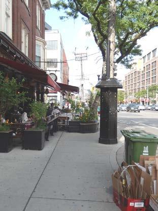
8 project scan (St Clair at Atlas) (Gerrard at Yonge) SIDEWALK DESIGN ISSUES Narrow pedestrian clearways


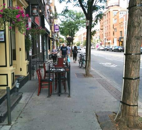
9 project scan SIDEWALK DESIGN ISSUES Pedestrians forced to weave around sidewalk cafes


10 project scan SIDEWALK DESIGN ISSUES Busy sidewalks


11 project scan SIDEWALK DESIGN ISSUES Café encroachments Marketing encroachments A-frame sign encroachments
12 project scan TORONTO S PEDESTRIAN CLEARWAYS Most existing policies and bylaws require a minimum 2.1m pedestrian clearway; Most existing policies and bylaws require a straight, unimpeded pedestrian clearway; Enhanced pedestrian clearways already exist on some of our busy downtown commercial streets. Chapter 743 Use of Streets & Sidewalks Publication dispensing boxes: "No installation shall be placed, installed or maintained within 3.6 metres of the curb on Yonge Street, from Queen Street to Bloor Street. Chapter 740 Street Vending Boulevard cafes: A total of at least 2.5 metres of paved sidewalk shall remain available for uninhibited pedestrian passage Toronto Community Council July 1998 Boulevard Marketing: a minimum clear sidewalk width of 3.05m Spadina between Queen and Baldwin Dundas between Spadina and Beverley
13 project scan STAKEHOLDER CONSULTATION Multi-phased public, industry and inter-divisional consultations; >20 stakeholder events, online survey, DAIAC and DRP; Input from >800 individuals. RESULTS Broad support for consistent rules, more design options and changes to application process; Most expressed concern with narrow obstructed clearways; Industry stakeholders felt strongly that existing café permit areas should remain as-is. ONLINE SURVEY RESULTS ( >500 Completed Surveys) Wide sidewalks and straight clearways for pedestrians to pass unhindered is a significant priority. Well designed and located patios can increase the attractiveness and ambiance of the street, and contribute to a more comfortable walking environment. Noise emanating from sidewalk cafés can, at times, become an issue. Flexibility to design creative and unique patios tailored to spaces and business needs is critical. Patios contribute to safe and vibrant neighbourhoods. A diverse and thriving patio culture should be supported by the City, BIA s, etc. through regulation and policy.
14 Summary of the Manual
15 supporting local businesses ADDITIONAL FLEXIBLITY AND DESIGN OPTIONS Additional sidewalk café options (curbside, parklet and small frontage café). Option to use neighboring frontage to expand café (if owner agrees). Reduction in clearway requirement to 1.8m for local roads. Reduced fencing requirements (planters, stanchions, portable fencing, no fencing). Fewer restrictions on choice of café furniture and fencing (need to be sturdy and safe). Year-round café operation in some instances. FAIR AND CONSISTENT PROCESSES Fair and consistent processes that are easy to understand and enforce. As-of-right approval for small frontage cafés. Streamlined application process. Streamlined notification process.
16 supporting residents & pedestrians SIDEWALKS OF SUFFICIENT WIDTH Sidewalks must be safe, accessible and comfortable to users of all ages and abilities. A minimum pedestrian clearway of 2.1m for arterial and collector roads and 1.8m in width for local roads unless the General Manager deems a greater width is required to safely accommodate pedestrians. Pedestrian clearway requirements set by staff are appealable to the General Manager of Transportation Services (delegated authority). Clearway requirements apply to sidewalk cafés and marketing (new applications and permit renewals). STRAIGHT SIDEWALKS CLEAR SIDEWALKS A pedestrian clearway that is straight and generally parallel to the property line, unless the General Manager agrees to an alternative alignment. Café activities and elements must be contained within the permitted café area.

17 key features DIVIDED INTO SIDEWALK DESIGN Understanding sidewalk zones and design principles. CAFÉ DESIGN Understanding café options and site design requirements. ELEMENT SELECTION Selecting the right café elements for your design. PULLING IT ALL TOGETHER Applying the three previous sections to various sidewalk types within the city.


18 key features CAFÉ TYPES Frontage café Small frontage café Flankage café Curbside café Parklet café CAFÉ COMBINATIONS Curbside & parklet Frontage & curbside Frontage & parklet

19 key features SITE DESIGN Sets out the site design requirements for the various café types and configurations

20 key features ACCESSIBILITY Accessibility requirements appear throughout the document


21 key features CAFÉ ELEMENTS Fencing and partitions Tables and chairs Awnings and umbrellas Café decks Temporary café enclosures Planters and planter boxes Branding and advertising Anchoring techniques Lighting Street trees
22 key features PULLING IT ALL TOGETHER Pulls together the sidewalk design, café design and café element sections together Shows the reader how the various design elements can be applied to different types of sidewalks Organized into wide, average and narrow sidewalk configurations
23 Next Steps
 City Council (March 28-30) PEDESTRIAN")

24 next steps COUNCIL REPORTING PWIC (February 28) L&SC (March 6) City Council (March 28-30) PEDESTRIAN PRIORITY MAPPING Develop city-wide pedestrian priority mapping and guidance. TRANSITION STRATEGY Refine transition strategy
25 Thank You!
Toronto Sidewalk Café Manual
 Toronto Sidewalk Café Manual SEPTEMBER 2015. TRANSPORTATION SERVICES. PUBLIC REALM SECTION FALL 2015 PROJECT UPDATE Project Overview the project THE MANUAL Describes the requirements for the design of
PROPOSED BYLAW UPDATES AND FEES FOR SIDEWALK CAFÉS & MARKETING DISPLAYS
 Transportation Services Municipal Licensing and Standards PROPOSED BYLAW UPDATES AND FEES FOR SIDEWALK CAFÉS & MARKETING DISPLAYS PUBLIC CONSULTATIONS June 13, 2017 Toronto City Hall June 20, 2017 North
Town of Beaumont Sidewalk Café Guidelines
 Town of Beaumont Sidewalk Café Guidelines 0 Table of Contents 1. Purpose... 1 2. Definition... 1 3. Project Area... 1 3.1 Town Centre-Mixed Use... 1 3.2 Direct Control... 1 4. Types of Sidewalk Cafés Permitted...
Road Alterations - Wellington Street East, Church Street, and Front Street Intersection
 REPORT FOR ACTION Road Alterations - Wellington Street, Church Street, and Front Street Intersection Date: November 1, 2016 To: Toronto and York Community Council From: Director, Public Realm Section,
Ann Arbor Downtown Street Plan
 1 Ann Arbor Downtown Street Plan Public Workshop #1 We know that. 2 Public right-of-way (streets, sidewalks, and alleys) make up 30% of the total District area of downtown. Streets need to provide mobility
122 Avenue: 107 Street to Fort Road
 : 107 Street to Fort Road November 24, 2015 4:30 8:00 p.m. Meeting Purpose Summarize project work completed to date Share results of public input from Phase 1 Share the draft concept plan and proposed
WELCOME. Purpose of the Open House. Update you on the project. Present a draft recommended plan. Receive your input
 WELCOME Purpose of the Open House The Town of Smiths Falls has initiated the Beckwith Street Redevelopment Plan that includes the preparation of a streetscape functional design for the renewal of Beckwith
Sidewalk Café Ordinance Group Report
 Neighborhood Advisory Council (NAC) 11 August 10, 2018 Sidewalk Café Ordinance Group Report 1. Introduction Downtown Frederick restaurants offer a variety of outdoor dining options that add to the attractiveness
complete streets design and construction standards public primer City of Edmonton
 complete streets design and construction standards public primer City of Edmonton introduction Complete Streets are streets for everyone: people who walk, wheel, bike, take transit, or drive. They are
Frequently Asked Questions (FAQ)
") Frequently Asked s (FAQ) Study Process... 2 Rapid Transit Service and Operations... 5 Public Consultation... 8 Business Impacts... 8 Design and Property Impacts... 9 Construction Impacts...12 Traffic,
Frequently Asked s (FAQ) Study Process... 2 Rapid Transit Service and Operations... 5 Public Consultation... 8 Business Impacts... 8 Design and Property Impacts... 9 Construction Impacts...12 Traffic,
A CHANGING CITY. of Edmonton, it is essential that it reflects the long-term vision of the City.
 A CHANGING CITY By the year 2040, Edmonton will be home to more than 1 million people. To accommodate growth and support a healthy and compact city, we need a new approach to development/redevelopment
Highland Creek Village Transportation Master Plan
 Highland Creek Village Transportation Master Plan Information Booklet On-Street Parking Discussion November 9, 04 Highland Creek Village Transportation Master Plan www.toronto.ca/hcvtransportation Old
Transportation Assessment
 Transportation Assessment Midtown Open House February 10, 2018 Overview Midtown in Focus Overview & Purpose of Today Transportation Assessment overview Summary of Transportation work to date Review & Analysis
FEDERAL HIGHWAY ADMINISTRATION APPLICATION
 FEDERAL HIGHWAY ADMINISTRATION APPLICATION REQUEST FOR PERMISSION TO EXPERIMENT WITH A BICYCLE BOX INTERSECTION TREATMENT Submitted by: City of Columbus Department of Public Service Date: June 26, 2009
Tonight is for you. Learn everything you can. Share all your ideas.
 Strathcona Neighbourhood Renewal Draft Concept Design Tonight is for you. Learn everything you can. Share all your ideas. What is Neighbourhood Renewal? Creating a design with you for your neighbourhood.
Arapahoe Square Zoning + Design Standards & Guidelines Task Force Meeting 9 January 27, 2016
 Arapahoe Square Zoning + Design Standards & Guidelines Task Force Meeting 9 January 27, 2016 Agenda 3:00 Opening/Welcome 3:15 Touch Base on Schedule and Milestones Moving Forward 3:20 Review the Overall
Long-term Urban Road Restrictions During Special Events. Kevin Phillips, P.Eng., AVS, Manager, Municipal Transportation, URS Canada Inc.
 Long-term Urban Road Restrictions During Special Events Kevin Phillips, P.Eng., AVS, Manager, Municipal Transportation, URS Canada Inc. Tia Nguyen, P.Eng., Transportation Engineer, Traffic Engineering
Two-Year Extension for Stationary Food Trucks (R55 Curb Lane Vending Permits)
") LS26.2 REPORT FOR ACTION Two-Year Extension for Stationary Food Trucks (R55 Curb Lane Vending Permits) Date: May 31, 2018 To: Licensing and Standards Committee From: Executive Director, Municipal Licensing
LS26.2 REPORT FOR ACTION Two-Year Extension for Stationary Food Trucks (R55 Curb Lane Vending Permits) Date: May 31, 2018 To: Licensing and Standards Committee From: Executive Director, Municipal Licensing
City of Toronto Complete Streets Guidelines
 Round One This is a summary of the Complete Streets Guidelines Survey posted on June 18 th, 2015 and live until July 2 nd, 2015. The survey was designed to solicit feedback on the draft Complete Streets
City of Lafayette Public Meeting Agenda Downtown Street Improvement Master Plan Implementation Committee Thursday, April 21, :00 PM
 1. CALL TO ORDER 2. ROLL CALL 3. ADOPTION OF AGENDA 4. PUBLIC COMMENTS 5. OLD BUSINESS 6. NEW BUSINESS City of Lafayette Public Meeting Agenda Downtown Street Improvement Master Plan Implementation Committee
FOCUS AREA 1 - Alberta Avenue Pocket Park 3 (121 Ave and 92 St)
") FOCUS AREA 1 - Alberta Avenue Pocket Park 3 (121 Ave and 92 St) New benches Plant evergreen trees Widen existing sidewalk from 1.5m to 1.8m Marked crosswalk 1.8m wide sidewalk Add pedestrian oriented lights
FOCUS AREA 1 - Alberta Avenue Pocket Park 3 (121 Ave and 92 St) New benches Plant evergreen trees Widen existing sidewalk from 1.5m to 1.8m Marked crosswalk 1.8m wide sidewalk Add pedestrian oriented lights
Village of Plainfield Design and Operational Guidelines for Outdoor Uses within the Public Right-of-Way
 Village of Plainfield Design and Operational Guidelines for Outdoor Uses within the Public Right-of-Way Table of Contents 1. Applicability... 2 Purpose: The Village of Plainfield wishes to allow outdoor
EXECUTIVE SUMMARY: TRANSIT-ORIENTED DEVELOPMENT IN SMITHS FALLS, ONTARIO; A COMPARISON BETWEEN TWO SITES
 EECUTIVE SUMMARY: TRANSIT-ORIENTED DEVELOPMENT IN SMITHS FALLS, ONTARIO; A COMPARISON BETWEEN TWO SITES Topic and Purpose In 2007, the Mayor of Ottawa s Task Force on Transportation suggested adding a
TORONTO WALKING STRATEGY
 CITY OF TORONTO t TORONTO WALKING STRATEGY EVERYONE IS A PEDESTRIAN ItitiORONM TORONTO MAYOR DAVID MILLER Toronto's Walking Strategy is a vision for a more liveable, prosperous and sustainable city. It
Appendix 1 Transit Network Analysis
 Appendix 1 Transit Network Analysis APPENDIX 1 TRANSIT NETWORK ANALYSIS The purpose of this appendix is to provide an update on the transit network analysis as it pertains to: i. SmartTrack ii. Scarborough
CITY OF SAINT JOHN TRAFFIC CALMING POLICY
 CITY OF SAINT JOHN TRAFFIC CALMING POLICY VERSION: 1.0 April 10, 2012 Pedestrians, Cyclists and Motorists Sharing Street Spaces CONTENTS INTRODUCTION... 3 POLICY GOAL... 3 POLICY OBJECTIVES... 3 GUIDING
Harbord Street and Hoskin Avenue Bicycle Lane Upgrades
 STAFF REPORT ACTION REQUIRED and Bicycle Lane Upgrades Date: April 22, 2014 To: From: Wards: Reference Number: Public Works and Infrastructure Committee General Manager, Transportation Services 19 and
Environment and Public Works Committee Presentation
 Mixed Use Centers Complete Streets Guidelines Project Environment and Public Works Committee Presentation December 10, 2008 Project Objectives: Conduct an inter-departmental and agency process to study
Chapter 3 DESIGN SPECIFICATIONS
 Brampton PathWays Planning and Design Guidelines 27 Chapter 3 DESIGN SPECIFICATIONS 3.1 CLASS 1 MULTI-USE PATH Off-road multi-use trails are the backbone of the Brampton PathWays Network. They are typically
Public Works and Infrastructure Committee. General Manager, Transportation Services
 STAFF REPORT ACTION REQUIRED Extending the Bay Street Bicycle Lanes Date: May 16, 2013 To: From: Public Works and Infrastructure Committee General Manager, Transportation Services Wards: Toronto Centre
Gardiner East. Gardiner Expressway & Lake Shore Boulevard Reconfiguration Environmental Assessment & Urban Design Study
 Gardiner East Gardiner Expressway & Lake Shore Boulevard Reconfiguration Environmental Assessment & Urban Design Study Press Conference February 5, 2014 1 What area are we studying? 2 Gardiner East in
Active Transportation Infrastructure Investment A Business Case
 Active Transportation Infrastructure Investment A Business Case In 2016, the Real Estate Foundation awarded the Capital Regional District a $50,000 grant for Shifting Gears: Land Use Change through Active
Saskatchewan Drive Roadway Rehabilitation and Shared-Use Path Widening
 Saskatchewan Drive Roadway Rehabilitation and Shared-Use Path Widening We are here today to present the draft plan for the Saskatchewan Drive Roadway Rehabilitation and Shared-Use Path Widening project
Strategies for Maintaining & Renewing Innovative Street Projects. Elyse Parker, Director of Policy & Innovation, City of Toronto NACTO, LA, 2018
 Strategies for Maintaining & Renewing Innovative Street Projects Elyse Parker, Director of Policy & Innovation, City of Toronto NACTO, LA, 2018 1 OUR ASSETS $12B in Assets $20B Replacement Cost $372M Capital
RESOLUTION NO ?? A RESOLUTION OF THE CITY OF NEPTUNE BEACH ADOPTING A COMPLETE STREETS POLICY
 RESOLUTION NO. 2018-?? A RESOLUTION OF THE CITY OF NEPTUNE BEACH ADOPTING A COMPLETE STREETS POLICY WHEREAS, safe, convenient, and accessible transportation for all users is a priority of the City of Neptune
Pattullo Bridge Replacement Project Community Connections Phase 2 Consultation. Appendix 3: Open House Display Boards
 Replacement Project Community Connections Phase 2 Consultation Appendix 3: Open House Display Boards November 2016 Welcome! Welcome to the Replacement Project Public Open House We Want to Hear from You
Community Task Force November 15, 2017
 Community Task Force November 15, 2017 Welcome and Introductions Project Partners Regional Transportation District (RTD) Colorado Department of Transportation (CDOT) Denver Regional Council of Governments
Bicycle and Pedestrian Advisory Committee (BPAC) November 21, 2013
 November 21, 2013") Bicycle and Pedestrian Advisory Committee (BPAC) November 21, 2013 OVERALL LAND USE CONCEPT Overall Broadway Valdez District: 95.5 acres (35.1 acres right-of ways + 60.4 acres developable land) Plan Subareas:
Bicycle and Pedestrian Advisory Committee (BPAC) November 21, 2013 OVERALL LAND USE CONCEPT Overall Broadway Valdez District: 95.5 acres (35.1 acres right-of ways + 60.4 acres developable land) Plan Subareas:
City of Ottawa s Complete Streets Approach to Transportation Projects
 City of Ottawa s Complete Streets Approach to Transportation Projects Presentation to Stakeholders Date: May 5, 2015 Presentation Overview Purpose of the study Proposed definition of Complete Streets for
Walking Along the Road. Module 2
 Walking Along the Road Module 2 Learning Outcomes: 2-2 At the end of this module, you will be able to: Describe the operational and safety benefits of shoulders and sidewalks Select the appropriate design
Alta Planning + Design
 Alta Planning + Design Gavin Davidson, MCIP, RPP Principal, Senior Planner Vancouver Kate Whitfield, P.Eng., MCIP, RPP Senior Associate Engineer/Planner Ottawa Ottawa, Ontario, Canada Ottawa Toronto Syracuse
DESIGN CODE. Enterprise West Harlow London Road North Design Code 21
 DESIGN CODE Enterprise West Essex @ Harlow London Road North Design Code 21 4 MAXIMUM BUILDING HEIGHTS 4.1 Table 4A sets out maximum building height standards for each character area within the LDO boundary.
Richmond Street and Adelaide Street Cycle Tracks
 IE1.05 REPORT FOR ACTION Richmond and Cycle Tracks Date: January 3, 2019 To: Infrastructure and Environment Committee From: General Manager, Transportation Services Wards: 10 (Spadina-Fort York), 13 (Toronto
NEIGHBORHOOD TRAFFIC CALMING POLICY
 NEIGHBORHOOD TRAFFIC CALMING POLICY I. PURPOSE The City of Kent continually strives to strengthen and protect its neighborhoods by improving the quality of life in residential areas. Traffic conditions
DRAFT - CITY OF MEDFORD TRANSPORTATION SYSTEM PLAN Roadway Cross-Sections
 Roadway Cross-Sections Medford s roadway cross-section standards apply to new and reconstructed roads. The crosssections take into consideration roadway function and operational characteristics, including
Zlatko Krstulich, P.Eng. City of O9awa
 Zlatko Krstulich, P.Eng. City of O9awa 1. Introduction to the Ontario Traffic Manual Series 2. What is OTM Book 18: Bicycle Facilities? 3. Study / Committee Team Members 4. Brief overview of the content
CLOSED. The draft concept design has been broken down into 5 categories for the purpose of this survey:
 Old Strathcona s neighbourhood renewal process is now at the draft concept design phase. Over the last several months, the city has been gathering local knowledge and resident input that has been used
General Plan Circulation Element Update Scoping Meeting April 16, 2014 Santa Ana Senior Center, 424 W. 3rd Street, Santa Ana, CA 92701
 General Plan Circulation Element Update Scoping Meeting April 16, 2014 Santa Ana Senior Center, 424 W. 3rd Street, Santa Ana, CA 92701 Meeting Agenda 1. Purpose of Scoping Meeting 2. Project Overview 3.
5. Pedestrian System. Accomplishments Over the Past Five Years
 5. Pedestrian System Accomplishments Over the Past Five Years The Alamo Area Metropolitan Planning Organization (MPO) and its partner agencies recognize the importance of improving pedestrian mobility.
Executive Summary Route 30 Corridor Master Plan
 Route Corridor Master Plan Project Overview The Route Corridor Master Plan is a coordinated multimodal transportation and land use plan for the entire stretch of Route through East Whiteland Township,
Toronto and East York Community Council. Director, Transportation Services, Toronto and East York District
 No Turn on Red Regulations STAFF REPORT ACTION REQUIRED Date: June 1, 2010 To: From: Toronto and East York Community Council Director, Transportation Services, Toronto and East York District Wards: Trinity
DEFINING THE STREETSCAPE DRAFT
 3 DEFINING THE STREETSCAPE Context Sensitive Design Context Sensitive Design The structuring elements of streetscapes for the City of Vaughan are road classifi cation, streetscape type and level of service.
CLOSED. Highlights of the Final Concept Design:
 The final Concept Design is the result of many months of listening, learning, creating, balancing, and understanding different needs and viewpoints, as well as incorporating technical requirements and
TRAFFIC CALMING GUIDE FOR TORONTO CITY OF TORONTO TRANSPORTATION SERVICES DIVISION
 TRAFFIC CALMING GUIDE FOR TORONTO CITY OF TORONTO TRANSPORTATION SERVICES DIVISION CITY OF TORONTO TRANSPORTATION SERVICES DIVISION 2016 TRAFFIC CALMING GUIDE FOR TORONTO TABLE OF CONTENTS Introduction
Classification Criteria
 SCHEDULE D TO RECOMMENDED OFFICIAL PLAN AMENDMENT NO. 40 SCHEDULE C-4 Road Criteria Criteria Traffic Service Objective Land Service/Access Typical Daily Traffic Volume Flow characteristics Travel Speed
FOLSOM-HOWARD STREETSCAPE OVERVIEW
 FOLSOM-HOWARD STREETSCAPE OVERVIEW SoMa residents should have the same kinds of amenities that other neighborhoods have. The Folsom- Howard Streetscape Project will make SoMa more livable by making it
ALBERTA AVENUE WHAT WE HEARD REPORT BUILDING GREAT NEIGHBOURHOODS
 ALBERTA AVENUE WHAT WE HEARD REPORT BUILDING GREAT NEIGHBOURHOODS FEBRUARY 2019 EXECUTIVE SUMMARY Starting in 2019, Alberta Avenue will see the replacement and enhancement of its aging collector and local
Broad Street Bicycle Boulevard City Council Study Session Summary
 Broad Street Bicycle Boulevard City Council Study Session Summary Overview: On August 15 th, 2017, a City Council Study Session was held to invite community input and request City Council guidance on a
2.0 LANE WIDTHS GUIDELINE
 2.0 LANE WIDTHS GUIDELINE Road Engineering Design Guidelines Version 2.0.1 May 2018 City of Toronto, Transportation Services City of Toronto Page 0 Background In early 2014, Transportation Services initiated
Telegraph Avenue Complete Streets DRAFT Recommendations. Oakland Public Works Department September 11 and 13, 2014 Open Houses
 Telegraph Avenue Complete Streets DRAFT Recommendations Oakland Public Works Department September 11 and 13, 2014 Open Houses Presentation Overview What are complete streets? What problem are we trying
Rochester Downtown Bicycle Study 2009
 Rochester Downtown Bicycle Study 2009 Relationship of ROCOG Long Range Transportation Plan to Rochester Comprehensive Plan Regional Long Range Transportation Plan (LRTP) is prepared under the auspices
Exhibit 1 PLANNING COMMISSION AGENDA ITEM
 Exhibit 1 PLANNING COMMISSION AGENDA ITEM Project Name: Grand Junction Circulation Plan Grand Junction Complete Streets Policy Applicant: City of Grand Junction Representative: David Thornton Address:
In station areas, new pedestrian links can increase network connectivity and provide direct access to stations.
 The Last Mile Planning for Pedestrians Planning around stations will put pedestrians first. Making walking to stations safe and easy is important; walking will be a part of every rapid transit Accessible
BETHEL ROAD AND SEDGWICK ROAD CORRIDOR STUDY
 DRAFT PLAN City Council Meeting August 14, 2017 STUDY AREA Sedgwick Corridor State Route 160, principal arterial with Class 3 access management designation, commuter and freight route, connection to SR
City of Toronto Road Classification System. Summary Document
 City of Toronto Road Classification System Summary Document City of Toronto Road Classification System Summary Document City of Toronto Copyright 2013 Published August 2013 CONTACT INFORMATION For information
10.0 CURB EXTENSIONS GUIDELINE
 10.0 CURB EXTENSIONS GUIDELINE Road Engineering Design Guidelines Version 1.0 March 2017 City of Toronto, Transportation Services City of Toronto Page 0 Background In early 2014, Transportation Services
Downtown Yonge BIA OBIAA Awards 2013 Submission Category: Special Events + Promotions
 Downtown Yonge BIA OBIAA Awards 2013 Submission Category: Special Events + Promotions CELEBRATE YONGE, Aug 17 Sep 16, 2012 Project Description Celebrate Yonge was a one-of-a-kind pilot event in the heart
TRANSPORTATION NEEDS ASSESSMENT
 TRANSPORTATION NEEDS ASSESSMENT A travel demand analysis was carried out to determine the operational issues and the potential benefit that adding traffic capacity would have on the road network. All the
Schutte Park Master Plan February 14, 2017
 Schutte Park Master Plan February 14, 2017 Overview The Schutte Park Master Plan is a product of the City of Dover Recreation Needs Assessment. This primary planning document for all of the city parks
WELCOME Public Information Centre
 WELCOME Public Information Centre Fernforest Drive Brampton Soccer Centre Community Room #2 Tuesday January 19, 2016 6:30 p.m.to 9:00 p.m. Please sign in Neighbourhood Traffic Calming Guide Background
Richmond-Adelaide Cycle Tracks
 Public Drop-In Event Richmond-Adelaide Cycle Tracks June 25, 2018 12:00 p.m. 3:00 p.m. 4:30 p.m. 7:30 p.m. Metro Hall, Rotunda 55 John Street 1 Purpose of Event In Scope Communicate an update about the
We support the following: Tom Davies Square 200 Brady Street Sudbury, Ontario
 April 4, 2014 Tom Davies Square 200 Brady Street Sudbury, Ontario RE: Second Avenue Reconstruction Project and Panel Consultation Dear City of Greater Sudbury Mayor and Council: The (SMAP), a council appointment
City of Wayzata Comprehensive Plan 2030 Transportation Chapter: Appendix A
 A1. Functional Classification Table A-1 illustrates the Metropolitan Council s detailed criteria established for the functional classification of roadways within the Twin Cities Metropolitan Area. Table
South False Creek Seawall Park Upgrades & Tree Replacements
 South False Creek Seawall Park Upgrades & Tree Replacements PARK BOARD COMMITTEE MEETING May 2, 2016 Recommendations A. THAT the Vancouver Park Board approve the design plan for the South False Creek Seawall
REPORT District of Maple Ridge
 REPORT District of Maple Ridge Traffic Calming Policy This report is prepared for the sole use of the District of Maple Ridge. No representations of any kind are made by Urban Systems Ltd. or its employees
STONY PLAIN ROAD STREETSCAPE
 Jasper Place Revitalization Strategy: Vision The people involved in the Jasper Place Revitalization Strategy envision: Goal 1: Feeling safe in our community Create a community where feeling safe is common--where
Downey Road. Transportation Improvement Study
 Downey Road Transportation Improvement Study Workshop 2 Participant Handbook Workshop 1 May 18 and 19, 2016 Workshop 2 June 23 and 28, 2016 Prepared By: City of Guelph Paradigm Transportation Solutions
Traffic Improvements for the Transit Oriented Development District (TODD) Meriden Public Library March 11, 2014
 Meriden Public Library March 11, 2014") Traffic Improvements for the Transit Oriented Development District (TODD) Meriden Public Library March 11, 2014 Project Overview Coordinate roadway improvements with other major projects HUB Flood Control
Traffic Improvements for the Transit Oriented Development District (TODD) Meriden Public Library March 11, 2014 Project Overview Coordinate roadway improvements with other major projects HUB Flood Control
VAN AKEN DISTRICT CONNECTIONS PLAN COMMUNITY MEETING #1 June 20, 2016 SMITHGROUP JJR WSP PARSONS BRINCKERHOFF STUDIO GRAPHIQUE
 VAN AKEN DISTRICT CONNECTIONS PLAN COMMUNITY MEETING #1 June 20, 2016 SMITHGROUP JJR WSP PARSONS BRINCKERHOFF STUDIO GRAPHIQUE 01 02 03 04 05 06 Project Overview + Goals RMS Development District-wide Connections
Public Works and Infrastructure Committee. General Manager, Transportation Services
 John Street Corridor Improvements Environmental Assessment Study STAFF REPORT ACTION REQUIRED Date: January 25, 2012 To: From: Wards: Reference Number: Public Works and Infrastructure Committee General
CITY OF SASKATOON COUNCIL POLICY
 and Parking Stalls Vending ORIGIN/AUTHORITY Legislation and Finance Committee Reports 14-1988, 19-1988, 36-1988; and 4-1994; Administration and Finance Committee Report No. 9-1998; Planning and Operations
Governance and Priorities Committee Report For the July 2, 2015 Meeting
 CITY OF VICTORIA For the July 2, 2015 Meeting To: Governance and Priorities Committee Date: From: Subject: Brad Dellebuur, A/Assistant Director, Transportation and Parking Services Executive Summary The
CONNECTIVITY PLAN. Adopted December 5, 2017 City of Virginia Beach
 CONNECTIVITY PLAN Adopted December 5, 2017 City of Virginia Beach CONTENTS 1.0 Background & Purpose... 2 2.0 Existing Inventory & Analysis... 3 ViBe District Existing Walking Conditions... 4 3.0 ViBe District
Chapter 7. Transportation. Transportation Road Network Plan Transit Cyclists Pedestrians Multi-Use and Equestrian Trails
 Chapter 7 Transportation Transportation Road Network Plan Transit Cyclists Pedestrians Multi-Use and Equestrian Trails 7.1 TRANSPORTATION BACKGROUND The District of Maple Ridge faces a number of unique
CITY OF ELKO BICYCLE AND PATHWAY PLAN
 CITY OF ELKO BICYCLE AND PATHWAY PLAN INTRODUCTION: The City of Elko is intended to provide the basic framework for the development of a functional bicycle and pathway system for the community with connections
Lake to Lake LAKE YORK. CYCLING ROUTE and WALKING TRAIL FEASIBILITY and DESIGN STUDY LAKE. CITY of REGION ONTARIO SIMCOE TORONTO
 LAKE SIMCOE Lake to Lake CYCLING ROUTE and WALKING TRAIL FEASIBILITY and DESIGN STUDY YORK REGION Overview Report JUNE 2013 CITY of TORONTO LAKE ONTARIO Table of Contents Study background 2 Study Background............................
Richmond-Adelaide Cycle Track Study Including Peter Street & Simcoe Street
 Richmond-Adelaide Cycle Track Study Including Peter Street & Simcoe Street Information Booklet #2 DRAFT November 5, 2013 Richmond St. west of University Ave. Table of Contents BACKGROUND... 3 WHAT S NEW
Great Streets are Great for Business
 Great Streets are Great for Business Mark Van Elsberg Project Manager Pedestrian Projects Public Realm Section Transportation Services, City Toronto NACTO Designing Cities October 24, 2014 NACTO 2014 DESIGNING
POLICY: TRAFFIC CALMING
 2006 MAY REFERENCE: COUNCIL APPROVED BY COUNCIL MAY 23, 2006 CITY OPERATIONS - NO. 608 POLICY: TRAFFIC CALMING A. All requests for traffic calming within the City shall be considered in accordance with
UPTOWN REGIONAL BIKE CORRIDORS PROJECT SAN DIEGO ASSOCIATION OF GOVERNMENTS
 UPTOWN REGIONAL BIKE CORRIDORS PROJECT SAN DIEGO ASSOCIATION OF GOVERNMENTS SUMMARY REPORT: COMMUNITY UPDATE MEETING February 6, 2014 6 8:30 p.m. Roosevelt Middle School Library 3366 Park Blvd, San Diego
Roadways. Roadways III.
 Introduction 97 Roadway Design Principles 98 Safe Speeds 99 Optimizing of Street Space 00 Minimum Lane Widths in the City of Boston 02 Design Features that Reduce Operating Speeds 05 Travel Lanes Transit
ST. GEORGE STREET REVITALIZATION: ROAD DIETS IN TORONTO
 Case Studies in Sustainable Transportation TORONTO, ONTARIO CASE STUDY 30 ST. GEORGE STREET REVITALIZATION: ROAD DIETS IN TORONTO Organization Status St. George Street revitalization completed Other lane
Public Works and Infrastructure Committee. General Manager, Transportation Services. P:\2014\Cluster B\TRA\TIM\pw14001tim.docx
 Eglinton Connects Environmental Assessment Study STAFF REPORT ACTION REQUIRED Date: March 25, 2014 To: From: Wards: Reference Number: Public Works and Infrastructure Committee General Manager, Transportation
Corporate Report. Recommendation
 Deferred by General Committee, August 25, 2014, Item 3.4 Corporate Report Report from Transportation and Environmental Services, Operations Date of Report: August 7, 2014 Date of Meeting: September 8,
SAN FRANCISCO MUNICIPAL TRANSPORTATION AGENCY
 THIS PRINT COVERS CALENDAR ITEM NO. : 11 DIVISION: Sustainable Streets BRIEF DESCRIPTION: SAN FRANCISCO MUNICIPAL TRANSPORTATION AGENCY Approving traffic modifications on Twin Peaks Boulevard between Christmas
4/14/2017 VIA . Miriam Lim, Junior Planner City of Sacramento Community Development Department 300 Richards, 3 rd Floor Sacramento, CA 95811
 4/14/2017 VIA EMAIL Miriam Lim, Junior Planner City of Sacramento Community Development Department 300 Richards, 3 rd Floor Sacramento, CA 95811 RE: Mack & Franklin Development (P17-016) Dear Ms. Lim:
Pedestrian Zones Gould Street/Victoria Street, and Willcocks Street
 STAFF REPORT ACTION REQUIRED Pedestrian Zones Gould Street/Victoria Street, and Willcocks Street Date: August 5, 2011 To: From: Toronto and East York Community Council Acting Director, Toronto and East
Public Works and Infrastructure Committee. General Manager, Transportation Services. P:\2016\Cluster B\TRA\TIM\pw16009tim.docx
 Ten Year Cycling Network Plan Date: May 3, 2016 STAFF REPORT ACTION REQUIRED PW13.11 To: From: Wards: Reference Number: Public Works and Infrastructure Committee General Manager, Transportation Services
REGIONAL BICYCLE AND PEDESTRIAN DESIGN GUIDELINES
 REGIONAL BICYCLE AND PEDESTRIAN DESIGN GUIDELINES November 16, 2011 Deb Humphreys North Central Texas Council of Governments Bicycle and Pedestrian Advisory Committee Snapshot of the Guide 1. Introduction
7/23/2017 VIA . Michael Hanebutt City of Sacramento Community Development Department 300 Richards Boulevard, 3 rd Floor Sacramento, CA 95811
 7/23/2017 VIA EMAIL Michael Hanebutt City of Sacramento Community Development Department 300 Richards Boulevard, 3 rd Floor Sacramento, CA 95811 RE: 65 th Street Apartments (DR17-220) Dear Mr. Hanebutt: