Waipio Point Access Road Acessible Path Concept Site Plan. Waipahu Aloha Clubhouse
|
|
|
- Dina Goodman
- 5 years ago
- Views:
Transcription
1 Waipio Point Access Road Acessible Path Concept Site Plan Waipahu Aloha Clubhouse
2 Problem Statement - There is no continuous or accessible pathway for Clubhouse members to walk to and from the bus stop on Farrington Highway. 80% of members commute by bus to the Clubhouse. - The diamond head side of the street is un-walkable due to the overgrown brush and parked cars. - The Clubhouse is located around a blind curve and there is no crosswalk for members to enter from the ewa side of the street. - Waipio Access Road slopes from the ewa side to the diamond head side. During heavy rains, roughly 18 of water accumulates at the bottom of the Clubhouse driveway making it difficult for members to enter the Clubhouse.
3

4 Precedent Study photo credit: Group70 International


5 Precedent Study photo credit: David Croxford photo credit: HSPLS


6 Summary from Concept Proposal Presentation 52% 48% concept a: develop a pathway on the diamond head side of Waipio Access Road Waipahu Aloha Clubhouse 07/14/16 DRAFT concept b: develop a pathway on the ewa side of Waipio Access Road


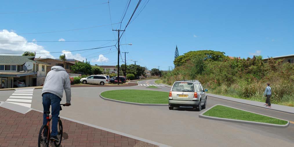
7 Water retantion pond and drainage trench Concept A - develop on the diamond head side of Waipio Access Road CONCEPT A 07/19/2016 PROGRESS MEETING Maria Petrova Eva Constantino Ann Motonaga Regina Amirova Crosswalk through Farrington HWY entry into area with crosswalk and green area Landscape and seating dedicated drop off and pick up location Drop-off/ Pick-up area for Waipahu High School Parking stalls marked parallel parking stalls drainage and water feature; accessible ramp to Clubhouse roundabout at poailani circle Roundabout intersection and crosswalk


8 Start of Multi-Use Recreational Path Concept B - develop on ewa side of Waipio Access Road CONCEPT B 07/19/16 PROGRESS MEETING Breeanna Garcia Austin Chun Kristen Patino Keelan Okazaki multi-lane recreational pathway Seating Areas and Parallel Parking Along New Accessible Path marked parallel parking stalls and rest areas New Accessible Crosswalks at Intersection accessible crosswalk and pathway Accessible Path Across the Waipahu Aloha Clubhouse accessible ramp to the Clubhouse New Crosswalk and Ramp Platform for the Waipahu Aloha Clubhouse
9 Waipio Point Access Road Acessible Path safe accessible sustainable meaningful

10 Concept Site Plan SUSTAINABILITY ACCESSIBLE TRAFFIC MANAGEMENT SAFETY
11 Connectivity Diagram Route to Waipio Point Soccer Park Pearl Harbor Historic Trail Bus Stop Bus Route FARRINGTON HIGHWAY Accesible Route to Clubhouse RAISED TABLE ADDED CROSSWALK ROUND ABOUT 2% WALKWAY WAIPIO POINT ACCESS ROAD SWITCHBACK WAIPAHU CLUBHOUSE CONNECTIVITY DIAGRAM
12 WAIPIO POINT ACCESS ROAD Connectivity Diagram Route to Waipio Soccer Park Pearl Harbor Historic Trail FARRINGTON HIGHWAY Bus Stop Bus Route WAIPAHU CLUBHOUSE WAIPIO PENINSULA SOCCER PARK CONNECTIVITY DIAGRAM

13 Entry Park after before

14 Waipio Street Entry after before
15 Waipio Street Entry Section GRATED DRAINAGE PLANTING STRIP SIDEWALK PLANTING STRIP WAIPIO POINT ACCESS ROAD SHOULDER LANE PARALLEL PARKING SLOPE SCALE: 1/8 = 1


16 Raised Table after before
17 Bus Drop Off Section WAIPAHU HS PLANTING planting strip STRIP SIDEWALK sidewalk planting strip PLANTING STRIP WAIPIO POINT ACCESS ROAD waipio point access road BUS DROP OFF bus drop off scale: 1/16 = 1 SCALE: 1/16 = 1

18 Waipio Access Road Driveway after before

19 Poailani Circle Roundabout after before
20 Poailani Circle Roundabout Section POAILANI poailani circle CIRCLE SIDEWALK sidewalk waipio point WAIPIO access road ROUNDABOUT roundabout WAIPIO POINT POINT ACCESS ACCESS ROAD ROAD waipio point access road planting strip PLANTING STRIP SIDEWALK sidewalk scale: 1/16 = 1 SCALE: 1/16 = 1
21 Accessible Ramp Section SIDEWALK sidewalk WAIPIO POINT ACCESS ROAD waipio point access road BIOSWALE bioswale ramp RAMP 0.00 SCALE: 1/8 = 1
22 Accessible Ramp Section SIDEWALK sidewalk WAIPIO ACCESS ROAD waipio point access road BIOSWALE bioswale RAMP ramp 0.00 SCALE: 1/8 = 1 scale: 1/8 = 1

23 Accessible Ramp Section SCALE: 1/8 = 1
24 Appendix
25 Light Medium Heavy Waipahu Aloha Clubhouse Site Analysis 07/18/16 DRAFT VEHICULAR TRAFFIC CONDITIONS DIAGRAM
26 Traffic direction Waipahu Aloha Clubhouse Site Analysis 07/18/16 DRAFT REGULATORY SIGNAGE DIAGRAM


 sidewalk")


27 traffic signals utility poles traffic box manholes cross walks metering boxes paved sidewalk asphalt sidewalk asphalt (narrow) sidewalk dirt sidewalk overgrown vegetation (sidewalk unusable sidewalk - grass Waipahu Aloha Clubhouse Site Analysis 07/18/16 DRAFT RIGHT OF WAY CONDITIONS DIAGRAM


28 Trees Shrubs and Bushes Waipahu Aloha Clubhouse Site Analysis 07/18/16 DRAFT NATURAL VEGETATION DIAGRAM
ROUTE 81 CORRIDOR STUDY DESIGN CONCEPTS
 RT 81 Corridor Study CLINTON ROUTE 81 CORRIDOR STUDY DESIGN CONCEPTS View north on High Street, with potential improvements to the streetscape Draft Recommendations November 8 th, 2018 TOWN OF CLINTON
APPENDIX A: Complete Streets Checklist DRAFT NOVEMBER 2016
 APPENDIX A: Complete Streets Checklist DRAFT NOVEMBER 2016 Complete Streets Checklist MetroPlan Orlando s Complete Streets Checklist is an internal planning tool for staff to further implementation of
01. VICINITY OF GREENBRAE POC: EXISTING CONDITIONS
 01. VICINITY OF GREENBRAE POC: EXISTING CONDITIONS Existing Bus Stop Existing US101 On-ramp Existing POC Old Redwood Highway Rich Street City ROW Environmental Study Limit Industrial Way NO DESIGNATED
Ocean Park Boulevard Green Street Project Alternatives & Trade Offs
 Planning Commission March 4, 2009 Ocean Park Boulevard Green Street Project Alternatives & Trade Offs Purpose of Tonight s Meeting Review concept plans and options Provide input on alternatives and trade-offs
Bicycle and Pedestrian Facilities Toolbox (Excerpt from Figure 3.1)
") Appendix B Neighborhood Connections Summaries This Appendix is a supplement to the information presented in Chapter 3 Connect People. The Appendix includes a summary or profile for each of the proposed
Appendix B Neighborhood Connections Summaries This Appendix is a supplement to the information presented in Chapter 3 Connect People. The Appendix includes a summary or profile for each of the proposed
Montgomery County Life Sciences Center Loop Trail
 Montgomery County Life Sciences Center Loop Trail Advisory Committee Meeting #1 February 10, 2015 Agenda 1. Project Background 2. Existing Conditions Analysis 3. Examples from Elsewhere 4. Discussion Project
Ocean Park Boulevard Streetscape Improvement Project Alternatives & Trade Offs
 City Council Study Session January 27, 2009 Ocean Park Boulevard Streetscape Improvement Project Alternatives & Trade Offs Scope of Work Purpose of Tonight s Meeting Review work to date and direct staff
NJDOT Complete Streets Checklist
 Background The New Jersey Department of Transportation s Complete Streets Policy promotes a comprehensive, integrated, connected multi-modal network by providing connections to bicycling and walking trip
Typical Cross Section: DOWNTOWN (Observer Highway - 8th Street)
") Typical Cross Section: DOWNTOWN (Observer Highway - 8th Street) DRAFT SEPTEMBER 23, 14 1 Washington Street Typical Block Downtown Typical Block: DOWNTOWN (Observer Highway - 8th Street) New crosswalks
Typical Cross Section: DOWNTOWN (Observer Highway - 8th Street) DRAFT SEPTEMBER 23, 14 1 Washington Street Typical Block Downtown Typical Block: DOWNTOWN (Observer Highway - 8th Street) New crosswalks
Mandan Commission Meeting August 2, 2016 Mandan City Hall
 Mandan-Bismarck Corridor Improvement Study Mandan Commission Meeting August 2, 2016 Mandan City Hall 2014 HDR, Inc., all rights reserved. Mandan Corridors Study Schedule 2015 2016 Study Kick Off August
NORTH LAUDERDALE WALKING AUDIT: VIRTUAL APPENDIX
 NORTH LAUDERDALE WALKING AUDIT: VIRTUAL APPENDIX TABLE OF CONTENTS VIRTUAL APPENDIX A: WALKING AUDIT FINDINGS... 3 Route 1 Notes... 3 Route 2 Notes... 5 Route 3 Notes... 6 Virtual Audit Notes... 8 VIRTUAL
Microscale Audit of Pedestrian Streetscapes (MAPS), Mini Version
, Mini Version") Microscale Audit of Pedestrian Streetscapes (MAPS), Mini Version Training Manual & Picture Guide Developed by: Carrie Geremia Kelli Cain Revised February 11, 2014 Tool and protocol developed by: James
Microscale Audit of Pedestrian Streetscapes (MAPS), Mini Version Training Manual & Picture Guide Developed by: Carrie Geremia Kelli Cain Revised February 11, 2014 Tool and protocol developed by: James
MAG Town of Cave Creek Bike Study Task 6 Executive Summary and Regional Significance Report
 Page 1 MAG Town of Cave Creek Bike Study Task 6 Executive Summary and Regional Significance Report August 1, 2012 MAG Project #481 Page 2 Task 6 Executive Summary and Regional Significance Report Introduction
Transportation Planning Division
 Transportation Planning Division Presentation Outline Study Tasks Recap of Previous Meetings Data Collected Focus Areas within Study Limits Design Principles Tool Box Recommended Concepts Schedule Moving
Complete Streets. Designing Streets for Everyone. Sarnia
 Complete Streets Designing Streets for Everyone Sarnia Complete Streets ~ Sarnia ~ 2018 Introduction Our City is made up of a network of streets that we use to go for a walk, cycle to work, drive to the
Item to be Addressed Checklist Consideration YES NO N/A Required Description Complete Streets Guidelines
 Passaic County Complete Streets Checklist - Concept Development Project Name Item to be Addressed Checklist Consideration YES NO N/A Required Description Complete Streets Guidelines Existing Plans Have
PART A: IDENTIFICATION/LOCATION
 Appendix A. Quick Bus Stop Checklist QUICK BUS STOP CHECKLIST A1 Street Name: PART A: IDENTIFICATION/LOCATION A2 Nearest Cross Street (street name or landmark if mid-block): A3 A4 A5 Bus Route Direction:
Chapter 7 Nonmotorized Facilities
 Chapter 7 Nonmotorized Facilities What is in this chapter? This chapter discusses existing and proposed pedestrian and bicycle facilities referred to as nonmotorized facilities along the SR 520 corridor.
Off-road Trails. Guidance
 Off-road Trails Off-road trails are shared use paths located on an independent alignment that provide two-way travel for people walking, bicycling, and other non-motorized users. Trails specifically along
PRINCE GEORGE S PLAZA METRO AREA PEDESTRIAN PLAN
 PRINCE GEORGE S PLAZA METRO AREA PEDESTRIAN PLAN May 28, 2008 Agenda Welcome and introductions Project overview and issue identification Planning context and strengths Design challenges and initial recommendations
Road Safety Evaluation ation A process to investigate traffic safety on tribal, county, or city roadways Roadway may be selected for evaluation if the
 Road Safety Evaluation Shoalwater Bay Roads WSDOT Highways & Local Programs Road Safety Evaluation ation A process to investigate traffic safety on tribal, county, or city roadways Roadway may be selected
Lynchburg District Update
 Lynchburg District Update Virginia Statewide Bicycle and Pedestrian Advisory Committee Spring Meeting May 16 th, 2017 David Cook Transportation Planner, VDOT Lynchburg District Table of Contents Active
TRANSPORTATION STANDARDS
 INTRODUCTION LOCAL STREETS ON-STREET PARKING SIDEWALKS STREET LIGHTING STREET FURNISHINGS TRAFFIC CALMING STREET TREES MEDIAN PLANTING BOULEVARD LOCATIONS VILLAGE CENTER STREET LOCATIONS RESIDENTIAL STREET
2010 STANDARD SPECIFICATIONS STANDARD DRAWINGS
 CITY OF REDMOND, OREGON 2010 STANDARD SPECIFICATIONS STANDARD DRAWINGS TABLE OF CONTENTS SECTION 1 TRENCHES TITLE 1-1 Utility Trench 1-2 Water Line & Sewer Line Separation 1-3 RR X-ING Single/Joint Use
INDEX. Geometric Design Guide for Canadian Roads INDEX
 Acceleration lane, see Lanes, Acceleration Access, 8.1 Access Management and Functional Classification 8.2 Access Management by Design Classification 8.3 Access Configuration 8.4 Building Set-Back Guidelines
All Season Age Friendly Pedestrian Safety and Walkability Checklist *
 FOSTERING AGE FRIENDLY, WALKABLE NEIGHBOURHOODS Walkability is a key component of optimal aging in Age Friendly cities. Walkable neighbourhoods promote physical and mental health and well-being, support
Identify the letter of the choice that best completes the statement or answers the question.
 Chapter 02 - Practice Questions Multiple Choice Identify the letter of the choice that best completes the statement or answers the question. 1) No-parking zones often are near a. fire hydrants, curves,
Board of Supervisors February 27, 2017
 : Traffic Analysis Results & Draft Conceptual Plan Board of Supervisors February 27, 2017 Transportation Solutions Building Better Communities Presentation Overview Background Summary of Traffic Analysis
Sidewalk Accessibility Checklist
 Starting Address: Ending Address: Date: Sidewalk Accessibility Checklist Please indicate your experience with any barriers you encountered when using the sidewalks in your neighborhood. 1. Did you have
Appendix B - Street Sections
 Appendix B - Street Sections 6TH STREET CORRIDOR PLAN STREET SECTIONS The street sections in Appendix B include recommended improvements to streets for North Glenwood. They include existing conditions
Chapter 3 DESIGN SPECIFICATIONS
 Brampton PathWays Planning and Design Guidelines 27 Chapter 3 DESIGN SPECIFICATIONS 3.1 CLASS 1 MULTI-USE PATH Off-road multi-use trails are the backbone of the Brampton PathWays Network. They are typically
Construction Specifications Manual
 Isle of Wight County Pedestrian and Bicycle Master Plan Construction Specifications Manual Adopted August 20, 2009 Introduction The Isle of Wight County Pedestrian and Bicycle Facilities Master Plan was
Poor pavement condition Substandard Intersections. / Substandard bike/pedestrian/transit accommodations. Driveway access Environmental concerns
 Public Informational Meeting University Avenue (Allen Boulevard Segoe Road) March 23, 2011 City of Madison City of Middleton Village of Shorewood Hills Dane County Existing Roadway Conditions Poor pavement
FOCUS AREA 1 - Alberta Avenue Pocket Park 3 (121 Ave and 92 St)
") FOCUS AREA 1 - Alberta Avenue Pocket Park 3 (121 Ave and 92 St) New benches Plant evergreen trees Widen existing sidewalk from 1.5m to 1.8m Marked crosswalk 1.8m wide sidewalk Add pedestrian oriented lights
FOCUS AREA 1 - Alberta Avenue Pocket Park 3 (121 Ave and 92 St) New benches Plant evergreen trees Widen existing sidewalk from 1.5m to 1.8m Marked crosswalk 1.8m wide sidewalk Add pedestrian oriented lights
COWETA HIGH SCHOOL AND EAST HIGHWAY 51
 COWETA HIGH SCHOOL AND EAST HIGHWAY 51 Lack of sidewalks along Ben Lumpkin Rd. Lack of crosswalks and ramps at intersection. Hwy 51 is wide to cross as a pedestrian. No ADA compliance or connection to
Controlled. Semi-Controlled PAGE 01 CHAPTER 12 INTERSECTIONS
 PAGE 01 CHAPTER 12 INTERSECTIONS You will cross many intersections while driving. Intersections are especially dangerous because vehicles are crossing each other s driving path. Many crashes happen at
BLUETT TRAFFIC CALMING ON-SITE MEETING #2 DISCUSSION SUMMARY
 BLUETT TRAFFIC CALMING ON-SITE MEETING #2 DISCUSSION SUMMARY Date: Wednesday, April 11, 2018 Time: 5:30 p.m. to 7:30 p.m. Location: Clague Middle School parking lot Attendees: Public Present: 42 Council
Traffic Signs and Signals
 CHAPTER FOUR Traffic Signs and Signals Traffic signs control traffic flow, making streets and highways safer for drivers, bicyclists and pedestrians. These signs, which are posted by the Indiana Department
PROJECT KEY TYPICAL SECTION 1 =60
 6 WASHINGTON BLVD - BETWEEN NE 1ST ST AND NE 3RD ST Washington Boulevard is a low volume, low speed one-way road, signed for no street between NE 1st Street and NE 2nd Street, and closed to traffic between
Paoli Road Improvement Feasibility Study
 Paoli Road Improvement Feasibility Study & Public Participation Project March 24, 2015 Prepared for: Tredyffrin Township Prepared by: McMahon Associates, Inc. with Town Planning Partnership, LLC Glackin
Victoria Park Master Plan
 Victoria Park Master Plan Phase I Presented By: ARCHITECTURAL ALLIANCE & HUGHES HUGHES INC. History of Victoria Park Phase I Purpose Inventory of Existing Conditions Identification of Options by Type (for
Ocean Park Boulevard Green Street Project Community Workshop
 Ocean Park Boulevard Green Street Project Community Workshop 2.2.10 Project Objectives Community Priority: reclaim OPB for public open space. Build upon LUCE principles; neighborhood enhancement, connectivity,
Appendix 3 Roadway and Bike/Ped Design Standards
 Appendix 3 Roadway and Bike/Ped Design Standards OTO Transportation Plan 2040 4/20/2017 Page A3-1 Adopted Standards The adopted OTO Design Standards and Major Thoroughfare Plan are contained herein.
MEDIAN DESIGN example median A
 MEDIAN DESIGN example median A MLK Blvd Design Workshop #3 September 21, 2010 Participants voted on each idea, gave comments about specific ideas or general comments about all ideas. Comments and suggestions
CITY OF SALEM DEPARTMENT OF PUBLIC WORKS STANDARD DRAWINGS TABLE OF CONTENTS
 001-099 100-199 200-299 Stormwater 300-399 400-499 500-599 600-699 700-799 800-899 Miscellaneous Sewers and Drains Streets Water Structures Earthwork Street Lighting and Traffic Signals Landscape and Irrigation
Agenda. Overview PRINCE GEORGE S PLAZA METRO AREA PEDESTRIAN PLAN
 PRINCE GEORGE S PLAZA METRO AREA PEDESTRIAN PLAN May 28, 2008 Agenda Welcome and introductions Project overview and issue identification Planning context and strengths Design challenges and initial recommendations
R A M P U P! - City of Tacoma's Curb Ramp Installation Matrix
 R A M P U P! - City of Tacoma's Curb Ramp Installation Matrix DESCRIPTION OF WORK NEW CONSTR. ALTERATION MAINT. COMMENTS STREET PAVING New street paving or overlay through an intersection (Figures 1 &
DRAFT. A fifth objective, other considerations, has been added to capture considerations not captured by the four primary objectives.
 TECHNICAL MEMORANDUM Albany - Washington Avenue Traffic Calming Evaluation Matrix of Conceptual Alternatives Date: May 17, 2017 Project #: 17356 To: Aleida Andrino-Chavez From: Laurence Lewis, Sara Muse,
Streetscape: Core Shopping District
 Streetscape: Core Shopping District DRAFT DRAFT DRAFT May 00 Core Shopping District: Phase Blue Island s Core Shopping District is located along Western Avenue, between Grove and Union Streets. Streetscape
2.0 Existing Conditions
 20 2.0 Existing Conditions 2.1 Land Use, Future Growth Patterns, Physical Barriers Geographic Overview Sutter County s land use pattern is characterized by extensive agricultural areas, significant natural
Safe Routes to School Action Plan Aberdeen, Idaho
 Background Aberdeen, Idaho is a largely agricultural community of nearly 2,000 people and is located in the southeast portion of the state on the western edge of American Falls Reservoir. The community
o n - m o t o r i z e d transportation is an overlooked element that can greatly enhance the overall quality of life for the community s residents.
 N o n - m o t o r i z e d transportation is an overlooked element that can greatly enhance the overall quality of life for the community s residents. 84 Transportation CHAPTER 11 INTRODUCTION Transportation
ACTIVE TRANSPORTATION Active Community Checklist
 ACTIVE TRANSPORTATION Active Community Checklist Safe, accessible spaces to walk, hike, bike and play is an important part of building strong, healthy and active communities for residents and visitors.
Chapter 6: Along the Street
 Chapter 6: Along the Street This section describes the types of infrastructure that should be in place along school routes to make walking and bicycling to school safer. Sidewalks In communities with sidewalks,
STREETSCAPE CONCEPTS
 STREETSCAPE S CARGO WAY CARGO WAY CYCLE TRACK Streetscape Concepts JENNINGS ST Illustrative Plan EVANS AVE PG&E BAY TRAIL HERON S HEAD PARK The recommended improvements build off the planned improvements
2017 Temporary traffic control guidelines for pedestrians. v.2
 2017 Temporary traffic control guidelines for pedestrians v.2 Temporary Traffic Control Guidelines for Pedestrians (2017) The safety and mobility of pedestrians, cyclists and motorists must be considered
CHAPTER 16 PEDESTRIAN FACILITIES DESIGN AND TECHNICAL CRITERIA TABLE OF CONTENTS
 CHAPTER 16 PEDESTRIAN FACILITIES DESIGN AND TECHNICAL CRITERIA TABLE OF CONTENTS Section Title Page 16.1 General... 16-1 16.1.1 AASHTO Reference... 16-1 16.1.2 ADA Requirements... 16-1 16.2 Sidewalks...
Broad Street Bicycle Boulevard Design Guidelines
 Broad Street Bicycle Boulevard Design Guidelines Building from the strategies introduced in the 2013 Bicycle Transportation Plan and community input received thus far, City Transportation Staff have identified
Lee s Summit Road Improvement Study Public Open House June 7, 2007 Summary of Comment Card Responses
 Lee s Summit Road Improvement Study Public Open House June 7, 2007 Summary of Comment Card Responses Introduction At the Lee s Summit Road Improvement Study Public Open House held Thursday, June 7, 2007
St. Francis Drive through the City of Santa Fe Corridor Study
 VII. ENGINEERING AND ENVIRONMENTAL EVALUATION TRAIL CONNECTIVITY In the southern portion of the Corridor there is a lack of a sidewalk, trail or bicycle facility within the right-ofway. However, the City
TANGIBLE CAPITAL ASSET (TCA) Reporting Guidelines for Land Development Projects
 Reporting Guidelines for Land Development Projects") January 2012 TANGIBLE CAPITAL ASSET (TCA) Reporting Guidelines for Land Development Projects 1. PURPOSE OF REPORTING The purpose of Tangible Capital Asset (TCA) reporting is to comply with PSAB 3150 reporting
January 2012 TANGIBLE CAPITAL ASSET (TCA) Reporting Guidelines for Land Development Projects 1. PURPOSE OF REPORTING The purpose of Tangible Capital Asset (TCA) reporting is to comply with PSAB 3150 reporting
Steps to Conducting a Complete Streets Assessment
 Steps to Conducting a Complete Streets Assessment Familiarize yourself with Complete Streets Read through the Complete Streets Assessment Guidelines. This will give you an idea of what Complete Streets
Morristown, NJ Complete Streets Policy
 Morristown, NJ Complete Streets Policy Introduction A Complete Street is defined as a means to provide safe access for all users by designing and operating a comprehensive, integrated, connected multi-modal
Blackfalds Downtown. Architectural Guidelines: Streetscape
 Blackfalds Downtown Architectural Guidelines: Streetscape Streetscape INTRODUCTION A variety of street furniture has been chosen for locations within the Town of Blackfalds Downtown and highway commercial
1.3 Pedestrian Environments
 SECTION 1: COMMERCIAL DEVELOPMENT 1.3 Pedestrian Environments Design Principle The quality of the pedestrian environment often defines the overall success of a commercial project. Attention to the development
Figure 3B-1. Examples of Two-Lane, Two-Way Marking Applications
 Figure 3B-1. Examples of Two-Lane, Two-Way Marking Applications A - Typical two-lane, two-way marking with passing permitted in both directions B - Typical two-lane, two-way marking with no-passing zones
Balancing Operation & Safety for Motorized and Non-Motorized Traffic
 Balancing Operation & Safety for Motorized and Non-Motorized Traffic Brian Willham, PE, PTOE Iowa Director - MOVITE June 30, 2014 Learning Objectives: When & Why should we measure the performance of complete
Hidden Oaks Elementary School
 Hidden Oaks Elementary School SCHOOL ROUTE PLAN For HIDDEN OAKS ELEMENTARY SCHOOL LOCATION 13 ORANGE COUNTY Prepared for: ORANGE COUNTY SCHOOL ASSESSMENT PROGRAM ORANGE COUNTY PUBLIC WORKS Traffic Engineering
City of East Grand Forks. ADA Transition Plan. Inventory Manual. June, 2018 DRAFT
 ADA Transition Plan City of East Grand Forks Inventory Manual June, 2018 DRAFT ADA Transition Plan City of East Grand Forks Inventory Manual Client City of East Grand Forks Consultant Team SRF Consulting
DISTRIBUTION: Electronic Recipients List TRANSMITTAL LETTER NO. (17-01) MINNESOTA DEPARTMENT OF TRANSPORTATION. MANUAL: Road Design English Manual
 MINNESOTA DEPARTMENT OF TRANSPORTATION. MANUAL: Road Design English Manual") DISTRIBUTION: Electronic Recipients List MINNESOTA DEPARTMENT OF TRANSPORTATION DEVELOPED BY: Design Standards Unit ISSUED BY: Office of Project Management and Technical Support TRANSMITTAL LETTER NO.
DISTRIBUTION: Electronic Recipients List MINNESOTA DEPARTMENT OF TRANSPORTATION DEVELOPED BY: Design Standards Unit ISSUED BY: Office of Project Management and Technical Support TRANSMITTAL LETTER NO.
Trans-Canada Highway 1 RW Bruhn Bridge Replacement
 Trans-Canada Highway 1 RW Bruhn Bridge Replacement May 2016 RW Bruhn Bridge Project Objectives Improve safety, traffic flow and movement of goods Improve safety for pedestrians and cyclists Replace the
Monroe Street Reconstruction Business Focus Group Notes July 18, 2016, HotelRED
 Monroe Street Reconstruction Business Focus Group Notes July 18, 2016, HotelRED Total participants: 31 Focus Group Conversation #1: During this exercise, participants talked in small table groups in response
Appendix T CCMP TRAIL TRAFFIC & TRANSPORTATION DESIGN STANDARD
 Appendix T CCMP 3.3.4 TRAIL TRAFFIC & TRANSPORTATION DESIGN STANDARD 3.3.4 Trail Traffic and Transportation Design Multi-use trails have certain design standards, which vary depending on the agency that
Mission-Geneva Transportation Study Community Workshop 2 July 8, 2006
 Community Workshop 2 July 8, 2006 Small Group Workbook 1 Basic Improvements on Mission Street Streetscape. Pedestrian-scale lighting; landscaping; community art on utility boxes; more (possibly unique)
Arlington Public Schools Thomas Jefferson Site Evaluation Transportation Networks. Thomas Jefferson Working Group Meeting #6 November 10, 2014
 Arlington Public Schools Thomas Jefferson Site Evaluation Transportation Networks Thomas Jefferson Working Group Meeting #6 November 10, 2014 2 3 INTRODUCTION 4 Goal of our work: Identify and assess multi-modal
ROUNDABOUTS/TRAFFIC CIRCLES
 GENERAL 1. Description This standard identifies minimum requirements that shall be met for Roundabouts and Neighborhood Traffic Circles in the design and construction of elements for Arlington County Horizontal
LAKE-TO-LAKES TRAIL. City Planning Commission October 7, 2014
 LAKE-TO-LAKES TRAIL City Planning Commission October 7, 2014 STAGE 3 ENGINEERING PLANS Project Overview Proposed in Shaker Heights Recreation & Leisure Plan (2005) Worked with regional partners to develop
Vision: Traditional hamlet with an attractive business/pedestrian friendly main street connected to adjacent walkable neighborhoods
 N D. Focus Area II Vision: Traditional hamlet with an attractive business/pedestrian friendly main street connected to adjacent walkable neighborhoods Transit Road Focus Area II is located in the Hamlet
RZC Appendix 8A Marymoor Subarea Street Requirements
 RZC Appendix 8A Marymoor Subarea Street Requirements For additional design details for Marymoor Subarea infrastructure, refer to the 2017 Marymoor Subarea Infrastructure Planning Report. STREET REQUIREMENTS
GIS Based Data Collection / Network Planning On a City Scale. Healthy Communities Active Transportation Workshop, Cleveland, Ohio May 10, 2011
 The Purpose of GIS Based Network Planning GIS Based Data Collection / Network Planning Healthy Communities Active Transportation Conference Tuesday, May 10, 2011 10:00 AM Norman Cox, LLA, ASLA. Ann Arbor,
RIVERSIDE, Newton MA BH NORMANDY RIVERSIDE LLC. Riverside Station. A green, transit-oriented community
 Riverside Station A green, transit-oriented community October 6, 2011 TONIGHT S AGENDA: 1. Project Update (5 min.) 2. Master Plan Update (10 min.) 3.Traffic Plan Update (10 min.) Questions & Answers MASTER
BICYCLE AND TRAILS ADVISORY COMMISSION Meeting Minutes
 Minutes Approved as Submitted Date: 8/10/17 Initials: EC BICYCLE AND TRAILS ADVISORY COMMISSION Meeting Minutes June 8, 2017 The Bicycle and Trails Advisory Commission was called to order at 4:00 p.m.
IMPLEMENTATION. PEDESTRIAN USERS (Continued /) Building Frontages: A: Stair Applications. Geometry (Accessed from the Sidewalk) Refer to A:
 Building Frontages: A: Stair Applications. Geometry (Accessed from the Sidewalk) Refer to A:") A: Stair Applications Building Frontages: Geometry (Accessed from the Sidewalk) Refer to A: Ramps should be provided for disabled users at 1:12 (8.3%) gradient. Ramp rises should be stepped at 400mm intervals.
A: Stair Applications Building Frontages: Geometry (Accessed from the Sidewalk) Refer to A: Ramps should be provided for disabled users at 1:12 (8.3%) gradient. Ramp rises should be stepped at 400mm intervals.
Preliminary Engineering Study
 Preliminary Engineering Study Open House # 2 June 6, 2018 PREPARED FOR: PREPARED BY: Agenda Background and status of preliminary engineering study County Road 26 design summary County Road 63 design summary
What Is a Complete Street?
 Session 5 Charleen Zimmer, AICP, Zan Associates May 5-7, 2010 What Is a Complete Street? May 2010 5-1 Not a Complete Street More of a Complete Street May 2010 5-2 Benefits of Complete Streets Safety for
Engineering Countermeasures for Transportation Safety. Adam Larsen Safety Engineer Federal Highway Administration
 Engineering Countermeasures for Transportation Safety Adam Larsen Safety Engineer Federal Highway Administration 360-619-7751 Adam.Larsen@DOT.GOV Countermeasure Selection Resources Manual for Selecting
Standards vs. Guidelines. Public Right-of Way Accessibility Guidelines (PROWAG)
") www.access-board.gov Public Right-of Way Accessibility Guidelines (PROWAG) Juliet Shoultz, P.E Transportation Systems Engineer US Access Board Standards vs. Guidelines Guidelines are developed by the Access
www.access-board.gov Public Right-of Way Accessibility Guidelines (PROWAG) Juliet Shoultz, P.E Transportation Systems Engineer US Access Board Standards vs. Guidelines Guidelines are developed by the Access
FY Candidate Sidewalk Projects. Sidewalk Advisory Committee
 FY 17-18 Candidate Sidewalk Projects Sidewalk Advisory Committee Sidewalk Advisory Committee FY 17-18 Candidate Sidewalk Projects January 3, 2017 County Road 540/Clubhouse Road (S. Lakeland) South-Side
Derby Street. Project Updates. Salem, Massachusetts
 Derby Street Project Updates Salem, Massachusetts September 13, 2017 Project Limits Derby Street Project Objectives 1. Improve complete streets elements on Derby Street 2. Improve sidewalks on finger streets
6.4 RECOMMENDED IMPROVEMENTS
 6.4 RECOMMENDED IMPROVEMENTS 6.4.1 Williston Road Recommendations While all alternatives would be an improvement over existing conditions, Alternative 3B is recommended over the others because it provides
4. TRAIL DESIGN GUIDELINES
 Trail Design Guidelines 4. TRAIL DESIGN GUIDELINES This chapter provides specific design guidelines for the Humboldt Bay Trail that are consistent with the guidelines currently observed in California and
RC-67M has been updated to include more details to be consistent with both ADAAG and PROWAG. The following slides discusses the general notes found
 RC-67M has been updated to include more details to be consistent with both ADAAG and PROWAG. The following slides discusses the general notes found on Sheet 1. RC-67M note Construct curb ramps with a minimum
SITE OBSERVATION FORM
 Sequential # Site ID: Sequential Number in pencil Injury Site B. Additional Site D. Additional Site E. Site type will be completed by the Study Coordinator after the Observation Form is completed. SITE
Downey Road. Transportation Improvement Study
 Downey Road Transportation Improvement Study Workshop 2 Participant Handbook Workshop 1 May 18 and 19, 2016 Workshop 2 June 23 and 28, 2016 Prepared By: City of Guelph Paradigm Transportation Solutions
Designing Pedestrian Facilities for Accessibility. Module 3 Curb Ramps & Blended Transitions
 Module 3 & Other Purpose: Allow pedestrians to transition between the street and sidewalks, islands, etc. Typically installed at: Intersections (1 ramp at each end of each crosswalk) Mid-block crossings
INGHAM COUNTY ROAD DEPARTMENT AUSTIN E. CAVANAUGH ADMINISTRATION BUILDING 301 Bush Street, P.O. Box 38, Mason, MI
 INGHAM COUNTY ROAD DEPARTMENT AUSTIN E. CAVANAUGH ADMINISTRATION BUILDING 301 Bush Street, P.O. Box 38, Mason, MI 48854-0038 March 27, 2018 William M. Conklin, P.E. Managing Director FOR IMMEDIATE RELEASE:
A. Arlington County Master Transportation Plan Pedestrian Element B. Arlington County Horizontal Standards H-3.1 Driveway Entrances
 GENERAL 1. Description This standard identifies minimum requirements that shall be met for all accessible ramps in the design and construction of elements for Arlington County Horizontal Design Standards.
Austin Avenue Bridges Project. Public Meeting Summary
 Austin Avenue Bridges Project Public Meeting Summary June 29, 2016 Red Table Safety and Connectivity Notes: 1. Would like to see forensic report evaluations 2. What is the lifespan? 3. Extend safety considerations
Ballston Station Multimodal Study WMATA and Arlington County. Meeting Minutes
 Date of Meeting: June 10, 2010 Location: Ballston Metrorail Station and NRECA Building 4301 Wilson Blvd, Arlington, VA Subject: Ballston Station Multimodal Study Stakeholder Meeting #1 Summary: This first
Design Guidelines. Overview. Design Vision for Yellow Brick Road
 Design Guidelines Overview This section presents the design vision for the Yellow Brick Road network. The Yellow Brick Road is envisioned to be an interconnected network of safe and secure roadways where