Taronga Wharf to Chowder Bay
|
|
|
- Cassandra Hardy
- 5 years ago
- Views:
Transcription


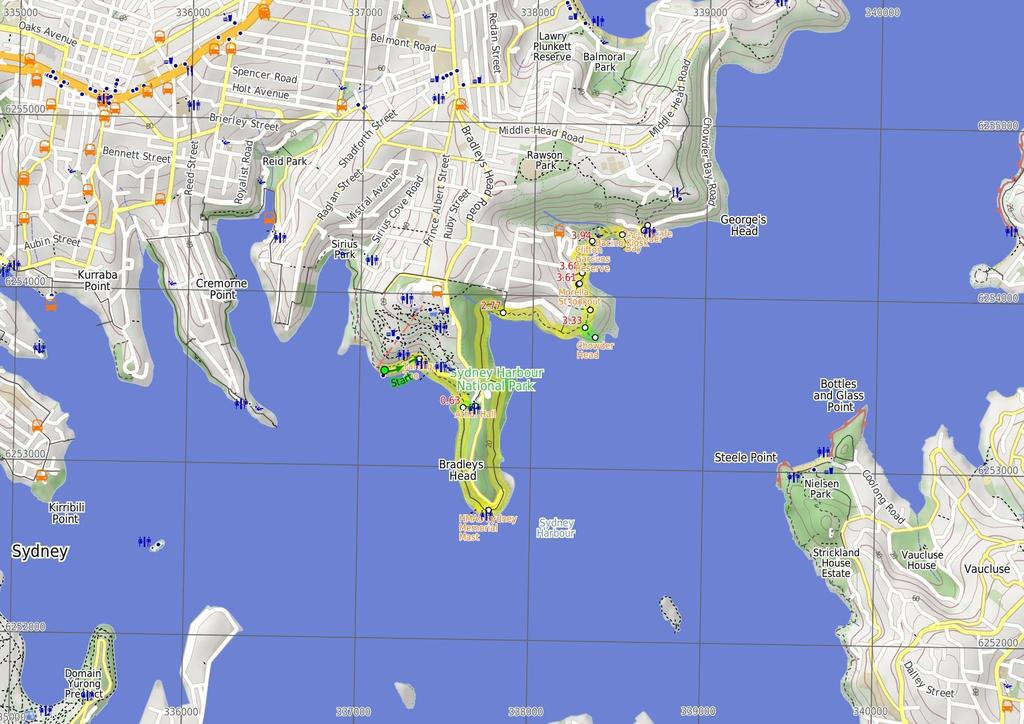
1 Taronga Wharf to Chowder Bay 2 hrs 4.4 km One way Moderate track 246m Starting at Taronga Wharf, this walk passes many icons of Sydney, including Taronga Zoo, HMAS Sydney Mast, Chowder Bay. The walk also provides views across the water to the Harbour Bridge, Opera House, Fort Denison and the city skyline. The walk has many brilliant vantage points over the harbour with some spots to stop for a coffee and lunch. A great walk to see Sydney Harbour from a different view. Maps, text & images are copyright wildwalks.com Thanks to OSM, NASA and others for data used to generate some map layers. 2m Sydney Harbour National Park 45m

2 Taronga Zoo Taronga Zoo was founded in 1916, with the vision of imitating the Hamburg Zoo's bar-less exhibits. Since its opening, Taronga Zoo has directed more attention to research, education and conservation efforts to support the animals. Taronga Zoo is open everyday 9am- 5pm. Phone: or groups@zoo.nsw.gov.au. More info. Athol Hall Athol Hall, built in 198, was once a hotel. Sections of the original building date back to the 18's. The hall has an excellent vantage point over the harbour with the Sydney Opera House, Harbour Bridge and city all well within its scope. Athol Hall today is a cafe and function centre with the cafe open Tues-Fri and Sun, 11am -pm. More info. HMAS Sydney Memorial Mast The HMAS Sydney Memorial Mast was erected in 194, following the HMAS Sydney's decommissioning in The mast stands as a sign of respect for 'Australian officers, sailors and ships lost at sea and in combat'. HMAS Sydney itself was a Chatham Class light cruiser which saw action in WW1. More info. Chowder Head Chowder Head provides a small unfenced rocky outcrop to enjoy the wide harbour views. From this vantage point, there are views across the water to South Head, Vaucluse, Rose Bay, Shark Island and Bradleys Head. A great spot to watch the sailing boats on a clear day. Morella St lookout This informally named clearing behind some houses on Morella St provides a great view across the harbour. The fairly large clearing has been maintained and is a good place to stop if wanting to avoid the large groups at Clifton Gardens. Before You walk Bushwalking is fun and a wonderful way to enjoy our natural places. Sometimes things go bad, with a bit of planning you can increase your chance of having an ejoyable and safer walk. Before setting off on your walk check 1) Weather Forecast (BOM Metropolitan District) 2) Fire Dangers (Greater Sydney Region, unknown) ) Park Alerts (Sydney Harbour National Park) 4) Research the walk to check your party has the skills, fitness and equipment required 5) Agree to stay as a group and not leave anyone to walk solo Think before you TREK The 'Think before you TREK' program developed by NSW Police & NPWS promotes the benefits of planning ahead for your bushwalking trip by using an easy to remember acronym: T R E K Take adequate supplies of food, water, navigation and first aid equipment. Register your planned route and tell friends and family when you expect to return. Emergency beacon (PLB's) should be carried on walks with significant gaps in mobile coverage (check terrain profile). Keep to your planned route and follow the map and walking trails. Topo Maps The maps provided on wildwalks are helpful, but there are times where you may need maps covering a broader area. Maps that cover this walk include; 1:25 Map Series:91N PARRAMATTA RIVER, 912N SYDNEY HEADS 1:1 Map Series:91 SYDNEY Grade This walk has been graded using the AS The overall grade of the walk is dertermined by the highest classification along the whole track. Length Time Quality of track Grade /6 Moderate track 4.4 km One way 2 hrs Formed track, with some branches and other obstacles (/6) Signs Directional signs along the way (/6) Experience Required Weather Infrastructure No experience required (1/6) Weather generally has little impact on safety (1/6) Limited facilities, not all cliffs are fenced (/6)
3 Are you ready to have fun? Please ensure you and your group are well prepared and equipped for all possible hazards and delays. Check park closures, weather information and Fire Danger Rating before setting out. Optional side trips and alternate routes noted are not included in this walks overall grade, length or time estimate. Please allow extra time for resting and exploring areas of interest. The authors, staff and owners of wildwalks take care in preparing this information but will not accept responsibility for any inconvenience, loss or injury you may experience. Please take care, have fun - Happy Walking. Getting there You can get to Taronga Zoo Wharf (gps: , ) by car, ferry or bus. Car: There is free parking available. You can get back from Roundabout at end of Chowder Bay Road (gps: -.884, ) by car or bus. Car: There is free parking available. Find up to date and more information inlcuding; travel directions, weather, park closures and walker feedback at Taronga Zoo Wharf (22 m 4 mins) From the wharf, the walk heads uphill along the footpath beside the road to the Taronga Zoo entrance at the pedestrian crossing..22 Taronga Zoo Taronga Zoo was founded in 1916, with the vision of imitating the Hamburg Zoo's bar-less exhibits. Since its opening, Taronga Zoo has directed more attention to research, education and conservation efforts to support the animals. Taronga Zoo is open everyday 9am- 5pm. Phone: or groups@zoo.nsw.gov.au. More info..22 Taronga Zoo Entrance (41 m 9 mins) Turn right: From the opposite the zoo entrance, the walk heads down the ramp leaving the road up to the left. The track soon leads to a a lookout with a set of bench seats and good harbour views. The walk continues along the footpath to a wire fence then follows the 'Walking Track' sign along the hillside to climb a few steps and cross a wooden bridge. The track comes to the corner of Athol Hall's grass clearing. Veer right: From the intersection, the walk heads down the stairs then continues along the hill for a short time. The walk descends more stairs to a signposted intersection..6 Optional sidetrip to Athol Hall (7 m 2 mins) Turn left : From the intersection, this walk follows the sign to 'Athol Hall' up the stairs, crossing a large grassy area. The walk then continues up to Athol Hall entrance. At the end of this side trip, retrace your steps back to the main walk then Veer left..6 Athol Hall Athol Hall, built in 198, was once a hotel. Sections of the original building date back to the 18's. The hall has an excellent vantage point over the harbour with the Sydney Opera House, Harbour Bridge and city all well within its scope. Athol Hall today is a cafe and function centre with the cafe open Tues-Fri and Sun, 11am -pm. More info..6 Int. Borogegal Walking Trail and Athol Hall Trk (67 m 16 mins) Continue straight: From the stairs, this walk heads around the hillside with the harbour below on the right. The walk travels across large sections of boardwalk which undulate slightly as the walk comes up to a trail (which leads to a bench overlooking Sydney Harbour). From the trail, this walk keeps contouring along the hillside, south and tending left, to the intersection, signposted as the way to 'Cannons picnic area'. Continue straight: From the intersection, this walk heads towards the car park, keeping the harbour to the right. The walk leads approximately 1m to the intersection with a track (leading down to Bradleys Head Amphitheatre). Veer left: From the intersection, this walk heads along the footpath next to the car park for a short distance, until it comes to be above the flag pole, HMAS Sydney Mast. 1. HMAS Sydney Memorial Mast The HMAS Sydney Memorial Mast was erected in 194, following the HMAS Sydney's decommissioning in The mast stands as a sign of respect for 'Australian officers, sailors and ships lost at sea and in combat'. HMAS Sydney itself was a Chatham Class light cruiser which saw action in WW1. More info. 1. HMAS Sydney Mast, Bradleys Head (79 m 17 mins) Continue straight: From the intersection, this walk heads along the footpath, keeping the road to the left, for about 15m to where the road bends sharply left. From this point, this walk heads along boardwalk, on your right, keeping the water glimpses to your right. The board walk soon end and this walk follows the track along the side of the hill for about 6m to come to an intersection with a sign pointing back to 'Bradleys Head'. 2.9 Optional sidetrip to Taylors Bay Lookout (5 m 1 mins) Turn right: From the intersection, the walk heads away from the main tracks winding into the bush. The track winds past two white benches, to a small rock shelf overlooking the water. At the end of this side trip, retrace your steps back to the main walk then Turn right. 2.9 Int. Borogegal Walking Trail and Taylors Bay Looko (68 m 17 mins) Continue straight: From the intersection, this walk heads into Taylors Gully, with Taylors Bay below on the right. The track continues for approximately m, contouring around the hill with views of Taylors Bay on the right. Tending right, this walk enters and exits Taylors Gully, to continue approximately 25m to the signposted intersection at the beginning of the houses, on the left Taylors intersection (57 m 14 mins) Continue straight: From the intersection, the walk heads along the line of the houses, on the left, for approximately 14m. The track passes a Japanese Submarine information sign on the right as it continues along sections of boardwalk track, to the intersection next to the last house. The walk heads up the stairs below the last house to be met by a large sandstone staircase on the left and a track to the front. Continue straight: From the intersection, this walk heads away from the house and clearing along the fairly flat track keeping the water glimpses to your right. The path soon leads to a clear three-way intersection with a 'Ashton Park' sign pointing back along the track.. Optional sidetrip to Chowder Head (9 m 2 mins) Turn right: From the intersection, this walk follows the 'Chowder Head' sign south-west along the clear track. The track heads gently downhill and bends left past some dead gums to find an unfenced rock platform with great harbour views. (Note the informal track continues down becoming steeper, leading to a small bay.) At the end of this side trip, retrace your steps back to the main walk then Veer right.. Chowder Head Chowder Head provides a small unfenced rocky outcrop to enjoy the wide harbour views. From this vantage point, there are views across the water to South Head, Vaucluse, Rose Bay, Shark Island and Bradleys Head. A great spot to watch the sailing boats on a clear day.. Chowder Head track intersection (11 m 2 mins) Turn left: From the intersection, this walk follows 'Clifton Gardens' sign gently up the hill. The track leads through the bush for a short time to soon come to another three-way intersection, this one marked with a 'Morella Rd' sign (on your left)..44 Bottom of Morella Rd track (17 m 4 mins) Veer left: From the intersection, this walk follows the main track keeping the water glimpses to your right (and the Morella Rd track to your left). The track gently works is way around the hill to come to a sign point back to 'Ashton Park' and a large clearing with good views behind some houses..61 Morella St lookout This informally named clearing behind some houses on Morella St provides a great view across the harbour. The fairly large clearing has been maintained and is a good place to stop if wanting to avoid the large groups at Clifton Gardens..61 Morella St lookout (8 m mins) Turn right: From the intersection, this walk follows 'Clifton Gardens' sign downhill along the concrete path, behind the line of houses. The path leads down the hill, following a series of steps past a bench seat to come to a 'T' intersection (with Sarah's Walk, part way down a set of steps)..68 Bottom of Sarahs walk steps (25 m 5 mins) Turn right: From the intersection, this walk heads down the steps that soon flatten out as the footpath leads around the headland under a few sandstone overhangs. The walk soon comes to a 'Foreshore Path' sign pointing back along the path at the south-western end of Clifton Gardens. Turn right: From the intersection, this walk heads down onto the beach, towards the wharf in the middle of the beach. The walk passes an Illawarra Flame tree, as it heads approximately 1m along the beach to the start of the wharf..94 Clifton Gardens Reserve Clifton Gardens was developed as a picnic spot in the late 18s, with a local hotelier building a wharf and dance pavilion. In 199, Sydney Ferries Ltd purchased the estate, and further developed the area, including a large swimming enclosure. The structure burned down in Today, Clifton Gardens is touted as 'remnant bushland', offering birdwatching, a netted swimming enclosure, change rooms, a fenced playground, and of course, spectacular views over Chowder Bay. A short bush track leads through to Rawson Oval..94 Clifton Gardens Baths (21 m 5 mins) Continue straight: From the wharf, this walk heads towards the playground-end of the beach. The walk leads along the beach, passing the playground and rocky outcrop on the left to tend right onto a boardwalk. The boardwalk takes the walk to the lower gate of Chowder Bay Bacino Kiosk The Bacino Kiosk, just next to Clifton Gardens, is a smaller version of the Bacino Bar above at Chowder Bay. This kiosk supplies passers-by with a home-blend coffee and sandwiches, and all at a reasonable price ($5-12). The Kiosk is open from 7am-4pm every day, except Christmas and bad weather. More info Chowder Bay Lower Gate (2 m 4 mins) Continue straight: From the gate, this walk heads towards the wharf approximately 8m away. The walk soon passes Bacino Kiosk on the left, and continues along the foreshore footpath to the start of the wharf.

4 Turn left: From the wharf, this walk heads directly away from that wharf, heading up the stairs. At the top of the stairs, this walk follows the footpath right, around a flag pole and house on the left. The walk continues past a round-about, to the start of a car park, opposite Bacino Bar. 4.7 Chowder Bay Chowder Bay looks over Sydney Harbour, to Vaucluse and Rose Bay. The bay is named after the food of the American whalers stationed at Clifton Gardens, 'clam chowder'. Chowder Bay then became a Submarine Mining Depot in Today, Chowder Bay still has great views from the remaining military buildings on the hillside. One of the newer buildings houses a cafe, and other buildings stand as monuments to their former use. Chowder Bay offers great views with easy access to Clifton Gardens for a swim. 4.7 Bacino Cafe The Bacino Bar is in Building No.2 at Chowder Bay, with great views across Sydney Harbour. The bar sells pastas, panini, arancini, tramezzini, stuffed eggplant and biscotti, along with homemade sandwiches and treats. The Bacino Bar prices are reasonable, ranging between $5-12 for the delicacies, and their coffee is made of their own blend. The bar is open every day from 7am- 4pm except for Christmas. A public toilet is available at the Eastern end of the building. More info.
5
6 Powered by TCPDF ( Summary navigation sheet for the Taronga Wharf to Chowder Bay km From Up/Dwn Length Initial directions (Use full tracknotes and maps for more detail) Start Taronga Zoo Wharf , (GR Parramatta River, 7156) m 4 mins From the wharf, the walk heads uphill along the footpath beside the road to the Taronga Zoo entrance at the pedestrian crossing..22 Taronga Zoo Entrance , (GR Parramatta River, 756) m 9 mins Turn right: From the opposite the zoo entrance, the walk heads down the ramp leaving the road up to the left..6 Int. Borogegal Walking Trail and Athol Hall Trk , (GR Parramatta River, 765) 9 7 m 2 mins Optional sidetrip to Athol Hall. Turn left : From the intersection, this walk follows the sign to 'Athol Hall' up the stairs, crossing a large grassy area..6 Int. Borogegal Walking Trail and Athol Hall Trk , (GR Parramatta River, 765) m 16 mins Continue straight: From the stairs, this walk heads around the hillside with the harbour below on the right. 1. HMAS Sydney Mast, Bradleys Head -.851, (GR Parramatta River, 78528) m 17 mins Continue straight: From the intersection, this walk heads along the footpath, keeping the road to the left, for about 15m to where the road bends sharply left. 2.9 Int. Borogegal Walking Trail and Taylors Bay Lookout track , (GR Parramatta River, 7855) -6 5 m 1 mins Optional sidetrip to Taylors Bay Lookout. Turn right: From the intersection, the walk heads away from the main tracks winding into the bush. 2.9 Int. Borogegal Walking Trail and Taylors Bay Lookout track , (GR Parramatta River, 7855) m 17 mins Continue straight: From the intersection, this walk heads into Taylors Gully, with Taylors Bay below on the right Taylors intersection , (GR Parramatta River, 7859) m 14 mins Continue straight: From the intersection, the walk heads along the line of the houses, on the left, for approximately 14m.. Chowder Head track intersection -.845, (GR Sydney Heads, 858) -1 9 m 2 mins Optional sidetrip to Chowder Head. Turn right: From the intersection, this walk follows the 'Chowder Head' sign south-west along the clear track.. Chowder Head track intersection -.845, (GR Sydney Heads, 858) m 2 mins Turn left: From the intersection, this walk follows 'Clifton Gardens' sign gently up the hill..44 Bottom of Morella Rd track , (GR Sydney Heads, 859) m 4 mins Veer left: From the intersection, this walk follows the main track keeping the water glimpses to your right (and the Morella Rd track to your left)..61 Morella St lookout -.841, (GR Sydney Heads, 8541) m mins Turn right: From the intersection, this walk follows 'Clifton Gardens' sign downhill along the concrete path, behind the line of houses..68 Bottom of Sarahs walk steps -.847, (GR Sydney Heads, 8541) m 5 mins Turn right: From the intersection, this walk heads down the steps that soon flatten out as the footpath leads around the headland under a few sandstone overhangs..94 Clifton Gardens Baths -.891, (GR Sydney Heads, 854) m 5 mins Continue straight: From the wharf, this walk heads towards the playground-end of the beach Chowder Bay Lower Gate -.887, (GR Sydney Heads, 85544) m 4 mins Continue straight: From the gate, this walk heads towards the wharf approximately 8m away.
Taronga Zoo to Spit Bridge
 Taronga Zoo to Spit Bridge 5 hrs Hard track 1.4 km One way 4 41m This is a scenic and culturally rich walk with views over Sydney Harbour and many interesting heritage buildings along the way. The start
Currie Rd to Davidson Park
 Currie Rd to Davidson Park 3 hrs 7.2 km One way Moderate track 28m Starting at Currie Rd in Forestville, this walk follows Middle Harbour to Davidson Park, under Roseville Bridge. There are two optional
Hunters Hill to Epping Road
 Hunters Hill to Epping Road 2 hrs 30 mins 5.5 km One way Moderate track 154m An enjoyable walk through lower sections of the Lane Cove National Park, this walk features plenty of mangroves next to the
Rail to River Walk. 3 hrs. Hard track 7.5 km Circuit. 222m
 Rail to River Walk 3 hrs Hard track 7.5 km Circuit 4 222m This walk is a great one from Chatswood Station to the Lane Cove River National Park. The walk descends through the vegetated bushland which fills
The Foreshore Walk. 24m. 1m Lake Macquarie LGA. 1 hr 15 mins 2.9 km One way. Hard track 81m
 The Foreshore Walk 1 hr 15 mins 2.9 km One way Hard track 81m This walk traverses the coastline of the Green Point reserve. By following a variety of tracks and occasionally traveling inland through eucalyptus
Govetts Leap Loop. 1065m. 909m Blue Mountains National Park. 4 hrs 30 mins 8.7 km Circuit. Hard track 380m
 Govetts Leap Loop 4 hrs 30 mins 8.7 km Circuit Hard track 380m This walk, from Blackheath Train Station, is a fantastic way to see some of the iconic areas of the Blue Mountains in the Blackheath area.
Little Digger Track. 68m. 1 Hr 2.2 km One way. Moderate track 93m. Moores Creek Reserve
 Little Digger Track Hr 2.2 km One way Moderate track 93m This walk follows Moores Creek through several reserves in east Roseville and East Lindfield. The track is named after Australia's 7th Prime Minster,
Little Digger Track to Davidson Reserve and Lyrebird Circuit
 Little Digger Track to Davidson Reserve and Lyrebird Circuit 4 hrs 3 mins 11.5 km One way Hard track 4 47m Exploring both the eastern and western sides of Middle Harbour Creek, this walk follows the Little
Echo Point to Leura Forest via Three Sisters and Giant Stairs loop
 Echo Point to Leura Forest via Three Sisters and Giant Stairs loop 3 hrs 3.8 km Circuit Hard track 512m This walk starts from the popular Echo Point, in Katoomba, and winds down to the base of the Three
Wentworth Falls Conservation Hut Loop
 Wentworth Falls Conservation Hut Loop 3 hrs Hard track 6.7 km Circuit 4 341m This scenic walk from Wentworth Falls Station, winds along the Nature Trail to Conservation Hut, then drops into the magnificent
Morgans Creek to Padstow
 Morgans Creek to Padstow 2 hrs 45 mins 8 km One way Moderate track 3 144m This pleasant walk starts from the Morgans Creek park, at Henry Lawsons Drive, and follows the Georges River past the Boomerang
Balmoral Beach to The Spit
 Balmoral Beach to The Spit 2 hrs 30 mins.3 km One way Hard track 85m This walks follows the coast from Balmoral to the Spit and across Spit Bridge. There are some alternate tracks to consider at high-tides,
Rail to River and Stringybark Creek Reserve Walk
 Rail to River and Stringybark Creek Reserve Walk 4 hrs Hard track 11.2 km Circuit 4 302m This walk begins in the busy city of Chatswood and soon enters the nearby bushland around the Lane Cove River. The
The Basin Track and Mackerel Track
 The Basin Track and Mackerel Track 3 hrs 5.9 km Circuit Hard track 226m This walk is a great way to see some popular areas in Ku-ring-gai Chase National Park. The walk from West Head Rd travels to The
Popes Glen, Pulpit Rock, Govetts Leap and Braeside Walk
 Popes Glen, Pulpit Rock, Govetts Leap and Braeside Walk 8 hrs Hard track 13.6 km Circuit 4 1068m This large circuit walk, from Popes Glen to Pulpit Rock, Govetts leap and along the Braeside Track, passes
Epping to Pennant Hills Station (via Lane Cove River)
") Epping to Pennant Hills Station (via Lane Cove River) 3 hrs 5 mins 8.4 km One way Hard track 249m This walk, from Epping to Pennant Hills Station, is a great way to see the upper Lane Cove River Valley.
Epping to Pennant Hills Station (via Lane Cove River) 3 hrs 5 mins 8.4 km One way Hard track 249m This walk, from Epping to Pennant Hills Station, is a great way to see the upper Lane Cove River Valley.
Katoomba Falls Circuit
 Katoomba Falls Circuit hr 5 mins.5 km Circuit Hard track 59m For those looking for a walk involving more than simple boardwalk, this trail winding through the temperate rain forest could be just the thing.
Mackerel Beach, West Head Loop
 Mackerel Beach, West Head Loop 5 hrs 8.6 km Circuit Hard track 422m The Mackerel Beach, West Head Loop is a walk which explores a large part of the West Head. The journey starts and finishes with a ferry
Waterfall to Heathcote
 Waterfall to Heathcote 5 hrs Hard track 10.8 km One way 4 467m This walk explores the heart of Heathcote National Park, and is easily accessed with a train station at either end. Although relatively close
Sid Pulsford Walk. 175m. 33m. 1 hr 45 mins 4.1 km One way. Hard track 118m. Gosford LGA
 Sid Pulsford Walk 1 hr 5 mins.1 km One way Hard track 118m Sid Pulsford Walk explores the ridge top of Kincumber Mountain, from Honeman's Rock to Green Point. The walk mostly follows wide management trails.
Heathcote to Engadine via Audley
 Heathcote to Engadine via Audley 6 hrs 3 mins 5 km One way Hard track 4 635m Covering a large section of central Royal National Park, this walk goes through the heath and scrub along a well managed and
Spit Bridge to Middle Head Forts
 Spit Bridge to Middle Head Forts 2 hrs 30 mins 6.3 km One way Hard track 4 181m This scenic walk takes you from the Spit Bridge, along the coast to explore the Middle Head Forts. There are a few alternate
Wallarah Coastal Walk
 Wallarah Coastal Walk 3 hrs 8.3 km Return Hard track 247m This walk starts at Caves Beach and travels south along the coastline, until reaching the Pinney s Headland Lookout. There are many opportunities
Epping to Eastwood Station (via Lane Cove River)
") Epping to Eastwood Station (via Lane Cove River) hrs 45 mins 10.2 km One way Moderate track 189m Epping to Eastwood, via Lane Cove River, is the longer route through the bush between the stations. This
Epping to Eastwood Station (via Lane Cove River) hrs 45 mins 10.2 km One way Moderate track 189m Epping to Eastwood, via Lane Cove River, is the longer route through the bush between the stations. This
Mackerel Beach and Resolute Loop
 Mackerel Beach and Resolute Loop 3 hrs 5.4 km Circuit Hard track 384m This walk is another great walk in Ku-ring-gai Chase National Park, accessed by ferry. From the Mackerel Beach wharf, this walk uses
Hornsby Blue Gum Walk
 Hornsby Blue Gum Walk 3 hrs Hard track 6.7 km Circuit 4 374m This delightful loop is one of the prettiest and most popular walks in the Hornsby area. Going from an environment of ferns and clear bushland
Carrington Park to Leura Forest and pass loop
 Carrington Park to Leura Forest and pass loop 3 hrs Hard track 4.8 km Circuit 4 674m This walk is a fantastic way to see Leura Forest. The walk descends from Carrington Park, visiting Leura Forest and
Wattamolla to Big Marley Beach
 Wattamolla to Big Marley Beach 4 hrs 10.4 km Circuit Moderate track 4m This walk is an excellent loop which takes in both the coast and the heathy inland of Royal National Park. Nearly the whole walk has
De Burghs Bridge to Fullers Bridge
 De Burghs Bridge to Fullers Bridge 2 hrs 3 mins Hard track 6 km One way 2m 4 Following the Lane Cove River, this walk mostly follows a section of the Great North Walk and is well maintained and signposted.
Dead Horse Gap Loop track
 Dead Horse Gap Loop track 4 hrs 30 mins Hard track 9.8 km Circuit 144m 4 This walk starts with a ride up the Kosciuszko Express Chairlift. There is an opportunity to eat at Australia's highest restaurant,
Campbell Drive to Snapper Point
 Campbell Drive to Snapper Point 1 hr 45 mins 4.2 km One way Experienced only 135m This walk follows the Coast Track to Frazer Beach, along the Geebung and (overgrown) Grass Tree Tracks. From the northern
Scenic World to Echo Point
 Scenic World to Echo Point 1 hr 15 mins 2.1 km One way Moderate track 192m This is one of the most popular tourist walks in the Katoomba area. The walk follows the cliffs along a well maintained and signposted
Woolwich Wharf to Boronia Park
 Woolwich Wharf to Boronia Park 2 hrs 5.8 km One way Moderate track 175m Going through the streets of Hunters Hill, this walk is on the first segment of the Great North Walk. The majority of the walk is
Teralba to Charlestown Park track head
 Teralba to Charlestown Park track head 4 hrs 30 mins 13.3 km One way Moderate track 3 220m This section of the Great North Walk starts from the Teralba train station and winds down and around the edge
Callicoma Loop. 174m. 98m. 2 hrs. Hard track 5.1 km Circuit. 153m
 Callicoma Loop 2 hrs Hard track 5.1 km Circuit 153m This great circuit walk passes through some really nice forest around the fringe of Cherrybrook. Highlights of the walk include some beautiful rock overhangs
Green Point Circuit Walk
 Green Point Circuit Walk 3 hrs 7.7 km Circuit Hard track 269m This walk visits all of the popular locations in Green Point Reserve, as well as some of the lesser-visited areas inland. Taking in Sea Eagle
Sphinx, Warrimoo and Bobbin Head tracks
 Sphinx, Warrimoo and Bobbin Head tracks 4 hrs 9.6 km Circuit Moderate track 499m This great walk starts at the Sphinx Memorial and loops around via Cowan Creek, exploring diverse environments as it changes
Bouddi Coastal Walk. 5 hrs. Hard track 8.1 km One way. 364m
 Bouddi Coastal Walk 5 hrs Hard track 8.1 km One way 4 364m This is one of the longer walks in the Bouddi National Park and it is rich in scenery. The walk follows the coastline with many side trips to
Patonga to Woy Woy. 5 hrs 45 mins 15.5 km One way. Hard track. 497m
 Patonga to Woy Woy 5 hrs 45 mins 15.5 km One way Hard track 4 497m This walk explores a variety of environments from the shore line and coastal cliffs near Patonga, to the dry, rocky and open ridge line.
Epping to Gordon Station
 Epping to Gordon Station 4 hrs 15 mins 11.7 km One way Hard track 4 365m This walk, from Epping Station to Gordon Station, passes below the homes which sit on the hills high above the Lane Cove River.
Middle Harbour Creek Loop
 Middle Harbour Creek Loop 5 hrs 45 mins 15.1 km Circuit Experienced only 5 570m This walk explores the upper reaches of Middle Harbour Creek, starting and ending at the great parklands at Davidson Park,
Upper Rumbalara circuit
 Upper Rumbalara circuit 1 hr 30 mins 3.3 km Circuit Hard track 176m A great circuit walk, covering most of the walking tracks and sights in the upper section of the Rumbalara Reserve. There is some really
Berowra to Mt Kuring-gai
 Berowra to Mt Kuring-gai 4 hrs 30 mins 9.4 km One way Hard track 4 551m From the ridges above Cowan Creek, this walk takes in some great lookouts (especially around Mt Kuringgai) as well as enjoying an
De Burgs Bridge to Thornleigh station
 De Burgs Bridge to Thornleigh station 3 hrs 45 mins 9.7 km One way Hard track 4 363m This walk follows a section of the Great North Walk, starting from De Burghs bridge. The walk winds north west, through
Hermitage Foreshore Track
 Hermitage Foreshore Track 1 Hr 2.2 km One way Moderate track 123m The Hermitage Foreshore Walk is a wonderful way to explore Sydney Harbour from the perspective of South Head. This walk starts from Nielsen
Roseville to Macquarie Park
 Roseville to Macquarie Park 3 hrs 3 mins 8.8 km One way Hard track 4 29m This walk starts at Roseville station and explores the streets and alleyways of Roseville before joining the main spine of the Great
Gordon to Chatswood Station
 Gordon to Chatswood Station 4 hrs 30 mins 12.2 km One way Hard track 4 381m This walk is a great way to get into the bush without being far from civilisation. The walk wanders through untouched valleys
Blackheath Station to Junction Rock Loop (via Grand Canyon and Popes
 Blackheath Station to Junction Rock Loop (via Grand Canyon and Popes 8 hrs 30 mins 18.2 km Circuit Hard track 4 1254m This circuit starts in Blackheath and heads down into the Grand Canyon and Rodriguez
National Pass from Wentworth Falls to Conservation Hut
 National Pass from Wentworth Falls to Conservation Hut 3 hrs Hard track 3.6 km One way 739m Starting at Wentworth Falls picnic area, this scenic and historic walk explores many waterfalls, lookouts and
Under and Over Cliff Walk
 Under and Over Cliff Walk 4 hrs 9.4 km Circuit Moderate track 576m This walk from Wentworth Falls Station is a fantastic way to see a large majority of the Wentworth Falls cliffline. The track winds under
Dubbo Gully and Ten Mile Hollow Circuit (via Clares Bridge)
") Dubbo Gully and Ten Mile Hollow Circuit (via Clares Bridge) 2 Days Hard track 24.3 km Circuit 4 1117m This two day (or ten hour) walk follows several historic roads, now closed to traffic. Starting with
Dubbo Gully and Ten Mile Hollow Circuit (via Clares Bridge) 2 Days Hard track 24.3 km Circuit 4 1117m This two day (or ten hour) walk follows several historic roads, now closed to traffic. Starting with
Lane Cove Tourist Park River Circuit
 Lane Cove Tourist Park River Circuit 5 hrs 12 km Circuit Hard track 383m This walk follows a large section of Lane Cove River. The walk follows the Riverside Walking track up the Lane Cove River to De
Glenbrook and Euroka Circuit
 Glenbrook and Euroka Circuit 2 Days 16.6 km Circuit Experienced only 790m This two day circuit, returning to Glenbrook Station, is a scenic walk which passes many of the tourist attractions within the
Wentworth Falls Station Loop (Undercliff Walk)
") Wentworth Falls Station Loop (Undercliff Walk) 4 hrs 3 mins Hard track 8.9 km Circuit 658m 4 This walk passes some stunning waterfalls and views into the Jamison Valley, following the cliff edges around
Wentworth Falls Station Loop (Undercliff Walk) 4 hrs 3 mins Hard track 8.9 km Circuit 658m 4 This walk passes some stunning waterfalls and views into the Jamison Valley, following the cliff edges around
Spit Bridge to Manly (Manly Scenic Walkway)
") Spit Bridge to Manly (Manly Scenic Walkway) 3 hrs 45 mins 9.1 km One way Moderate track 349m The Spit to Manly walk is a classic bushwalk on Sydney's Northern Beaches. The walk follows a well-maintained
Spit Bridge to Manly (Manly Scenic Walkway) 3 hrs 45 mins 9.1 km One way Moderate track 349m The Spit to Manly walk is a classic bushwalk on Sydney's Northern Beaches. The walk follows a well-maintained
Federal Pass Walking Track
 Federal Pass Walking Track 5 hrs Hard track 8 km One way 4 989m This classic trail follows along the base of the cliffs from Leura to the Golden Stairs, passing many of the more popular sights of the Katoomba
Sphinx to Mt Kuring-gai
 Sphinx to Mt Kuring-gai 4 hrs 45 mins 1.7 km One way Hard track 673m This walk starts at the Sphinx War Memorial and follows some well maintained and popular walking tracks down to Cowan Creek. Enjoy the
Echo Point to Leura Forest Circuit
 Echo Point to Leura Forest Circuit 3 hrs 4.8 km Circuit Hard track 588m Forming a circuit around the cliffs and then the valley floor, this is a walk more then capable of convincing a walker of the beauty
North Ryde Fairyland circuit
 North Ryde Fairyland circuit 2 hrs 30 mins Hard track 6.9 km Circuit 193m 4 Starting at North Ryde train station this walk explores a stretch of the Lane Cove River, visiting the historic Fairlylands Pleasure
Thornleigh to Hornsby
 Thornleigh to Hornsby 4 hrs Hard track 10.2 km One way 4 526m Starting at Thornleigh station you walk through suburban streets for a short while before diving into the bush at the southern end of Berowra
Wentworth Falls Station Loop
 Wentworth Falls Station Loop 5 hrs 3 mins 9.5 km Circuit Hard track 4 13m The Wentworth Falls Station Loop takes in most of the upper tracks around Wentworth Falls. There are many scenic views near the
Manly to Seaforth Oval
 Manly to Seaforth Oval 5 hrs 45 mins 13.7 km One way Moderate track 3 624m This walk follows the Manly to Spit Scenic Walkway, then continues past The Spit Bridge to Seaforth Oval. The walk provides magnificent
Charlestown Park trackhead to Newcastle station
 Charlestown Park trackhead to Newcastle station 5 hrs 30 mins 12.1 km One way Hard track 4 287m This section of the Great North Walk starts from the Charleston Park track head and winds through the streets
Wentworth Falls Loop. 893m. 665m. 6 hrs 10.2 km Circuit. Hard track 1093m. Blue Mountains National Park
 Wentworth Falls Loop 6 hrs 1.2 km Circuit Hard track 193m This is a great walk, both in size and spectacular views. The walk makes its way from Wentworth Falls train station and drops off the plateau,
Bobbin Head Loop. 166m. 0m Ku-ring-gai Chase National Park. 5 hrs 12.9 km Circuit. Hard track 619m
 Bobbin Head Loop 5 hrs 12.9 km Circuit Hard track 619m This great circuit walk enjoys a variety of landscapes in Ku-ring-gai Chase National Park. The walk starts at the historic Sphinx war memorial and
Faulconbridge to Blaxland
 Faulconbridge to Blaxland 2 Days Experienced only 15.2 km One way 5 693m This two-day walk, or very solid one-day walk, takes you from station to station, through lush, scenic forest in the lower Blue
Gosford to Lisarow. 202m
 Gosford to Lisarow 4 hrs 3 mins Hard track 11.3 km One way 4 479m This walk is a great way to explore the ridge-top bushland between Gosford and Lisarow. Passing through Rumbalara and Katandra Reserves,
Chatswood to Epping Station
 Chatswood to Epping Station 6 hrs Hard track 16.3 km One way 4 533m This walk, from Chatswood to Epping, is a long but enjoyable walk along the Lane Cove valley. The walk mostly follows the Lane Cove River
Bouddi Ridge and Coastal Walk
 Bouddi Ridge and Coastal Walk 2 Days Hard track 27 km Circuit 4 126m This overnight walk takes in the majority of the magnificent Bouddi National Park. The walk starts from the pleasant Putty Beach camping
Scenic world to Three Sisters Loop via Furber Steps
 Scenic world to Three Sisters Loop via Furber Steps 5 hrs 5.8 km Circuit Hard track 722m This walk starts from the popular Scenic World, in Katoomba, and winds down the Furber steps into the Jamison Valley,
The Coast Track. 2 Days. Hard track 27.4 km One way. 1351m
 The Coast Track 2 Days Hard track 27.4 km One way 4 1351m Heading south, this walk covers the coastline of the Royal National Park and can truly only be described as amazing. With breathtaking coastal
Rumbalara Explorer. 158m. 5m Rumbalara Reserve. 2 hrs 45 mins 6.1 km Circuit. Hard track 326m
 Rumbalara Explorer 2 hrs 5 mins 6.1 km Circuit Hard track 326m Pretty well the grand tour of the Rumbalara Reserve, this walk takes in much of the great scenery the reserve has to offer. The walk covers
Cape Banks Circuit. 50m. 2m Botany Bay National Park. 3 hrs 7.3 km Circuit. Hard track 190m
 Cape Banks Circuit 3 hrs 7.3 km Circuit Hard track 19m This Cape Banks Circuit has a lot to offer and is thoroughly recommended. The walking travels over beaches, through coastal forest and across exposed
Narrabeen Lagoon Trail (from Middle Creek)
") Narrabeen Lagoon Trail (from Middle Creek) 2 hrs 30 mins 8.6 km Circuit Very easy 1 105m The Narrabeen Lagoon Trail is a wonderful and accessible walk on the Northern Beaches of Sydney. The trail is used
Narrabeen Lagoon Trail (from Middle Creek) 2 hrs 30 mins 8.6 km Circuit Very easy 1 105m The Narrabeen Lagoon Trail is a wonderful and accessible walk on the Northern Beaches of Sydney. The trail is used
Light to Light Walk 2 days
 Light to Light Walk 2 days 2 Days Hard track 3.9 km One way 4 794m Over two days, this classic walk explores the coast from Boyd Tower to the Green Cape Lighthouse in the south. Hegartys Bay Camp is over
Harbour Bridge to Taronga Zoo
 Harbour Bridge to Taronga Zoo 4 hrs 9.8 km One way Moderate track 389m On this walk, you will explore much of the foreshore linking Milsons Point Station to Taronga Zoo Ferry wharf. The walk is mostly
Sydney to Thornleigh via Lane Cove Tourist Park
 Sydney to Thornleigh via Lane Cove Tourist Park 2 Days 33 km One way Hard track 4 1114m This overnight walk starts from the Obelisk in Macquarie Park, Sydney, at the official start of the Great North Walk.
MAP BOOKLET IMPORTANT CONTACTS SUNDAY 24 MARCH In an emergency please call 000 Medics. Event contacts
 SUNDAY 24 MARCH 2019 Help raise funds for the Cancer Centre for Children at The Children s Hospital at Westmead MAP BOOKLET IMPORTANT CONTACTS In an emergency please call 000 Medics (02) 8005 MEDIC or
Six Foot Track. 1212m
 Six Foot Track 3 Days 44.8 km One way Hard track 4 2066m This classic walk takes you from Katoomba to Jenolan Caves via a historic horse route. The walk travels mainly along well-maintained service tracks
RILLINGTON TO MALTON by Tania Dickinson
 RILLINGTON TO MALTON by Tania Dickinson This walk takes you from the Vale of Pickering up on to the Wold scarp, before dropping down again through the pretty village of Settrington and joining the Centenary
MAPS & WALK NOTES. DAY 2: Greenwich Wharf to Woolwich Wharf
 MAPS & WALK NOTES DAY 2: Greenwich Wharf to Woolwich Wharf Total Distance: 15.5km Time: Approximately 5 hours 30 mins five Sections Walk Notes in Section Name Length Time 2:1 Greenwich Wharf to Northwood
Christchurch to Hengistbury Head
 Last checked 6 June 2018 Document last updated: 13 July 2018 This document and information herein are copyrighted to Saturday Walkers Club. If you are interested in printing or displaying any of this material,
Walk 7: Watchet to washford
 Walk 7: Watchet to washford Length: Moderate - 7.5 miles / 12 km Good For: Theme: History Duration: 2-3 hours depending on speed of walking Notes: This is a moderate to difficult walk in places, with steps,
LDWA SOUTH DOWNS MARATHON 13 th MAY 2018
 AHD ahead SDW South Downs Way BL/BR bear left/bear right TL/TR turn left/turn right X cross LEG 1 - EAST DEAN to WP1 NORTON GR 470019. Open 1030 to 1300. 9.7 miles. 1.1 From village hall TL and walk to
Beautiful Walks from the Blue Ball Inn
 Walk No. 7 COAST AND VALLEY WALK Countisbury, Glenthorne, County Gate, Brendon, Rockford and Wilsham 10 MILES APPROX. Walking time 5 hours approx. (not including breaks)> OS Sheet 64/74 Lynton and Lynmouth.
Start / Finish. Version 2
 Start / Finish Version 2 Gosford (Start) to Woy Woy Head South down Etna Street, crossing Henry Parry Drive, then Mann St, Gosford, where Etna St becomes Racecourse Road. Follow this road all the way
LDWA SOUTH DOWNS MARATHON
 AHD ahead SDW South Downs Way BL/BR bear left/bear right TL/TR turn left/turn right SP signpost/fingerpost X cross LEG 1 - EAST DEAN to WP1 NORTON GR 470019. Open 1030 to 1300. 9.6 miles. 1.1 From village
ST. AGNES. you cannot put a time limit on beauty.
 ST. AGNES CIRCULAR WALKS AROUND There are many enjoyable and picturesque walks around St. Agnes most are signposted and are featured on the St. Agnes Mini-guide map. Because most of our footpaths are in
SELF GUIDED TOURING ROUTE
 SELF GUIDED TOURING ROUTE Things to see and places to go on the loop from Orbost to Marlo, Cape Conran, Cabbage Tree and back to Orbost (or onwards to Cann River) V6 April 2017 This guide should be read
ULTRA-TRAIL AUSTRALIA May 2018 COURSE DESCRIPTION AND COURSE NOTES
 ULTRA-TRAIL AUSTRALIA 100 19-20 May 2018 COURSE DESCRIPTION AND COURSE NOTES LEG 1 Scenic World (Start) to Narrow Neck (Checkpoint 1) Course Description: From the start, at the front entrance of Scenic
Rhossili - Tears Point - Mewslade Bay - Talgarth's Well - Rhossili - ID: 148. Walk description:
 Walk description: A glorious walk combining thrilling cliffs with beautiful wild beaches and a bird's-eye view of the Gower peninsula from Rhossili Down. The adventurous can walk out to the Worm's Head
A Walk from Our Lady of Victories Church, Bowen Hills to The Cathedral of Saint Stephen
 A Walk from Our Lady of Victories Church, Bowen Hills to The Cathedral of Saint Stephen 1 0.0km 30m 185m 270m From the Start to Breakfast Creek Rd is 8 minutes This pilgrimage walk should take the average
Access Statement for Loch of Strathbeg
 This access statement does not contain personal opinions as to our suitability for those with access needs, but aims to accurately describe the facilities and services that we offer all our guests/visitors.
Hexham Abbey to the Racecourse Road
 Hexham Abbey to the Racecourse Road The Yarridge Road, or Racecourse Road as it is often known, runs along the ridge line to the south of Hexham and provides wonderful views of the river valley and fells
THE BECK STONE Backstone Beck on Ilkley Moor
 THE BECK STONE Backstone Beck on Ilkley Moor 1 Three different routes which take in the best of the lower slopes of Ilkley Moor, with bracken, heather, a tarn (a small mountain lake) and rushing streams.
The Year Of Mercy Pilgrimage Sts Peter and Paul s Church, Bulimba To The Cathedral of St Stephen
 The Year Of Mercy Pilgrimage Sts Peter and Paul s Church, Bulimba To The Cathedral of St Stephen Dist Route Photos Photos 0.0km St Peter and Paul s Church, 235 Riding Rd & Cnr Main Ave, Balmoral. http://www.bulimbacatholic.com/
Navigating Briones: getting around an advanced orienteering course. Brown Course, October 2011.
 Navigating Briones: getting around an advanced orienteering course. Brown Course, October 2011. The trek to the start this year wasn t short and boy was it steep. But this should be treated as an opportunity
The Hundred Parishes
 The Hundred Parishes Walks from railway stations number 9 6.4 miles (10kms) from Bishop s Stortford to Stansted Mountfitchet Start: Bishop s Stortford station (Grid Reference TL492209) (ample parking and
DOWNLOAD OR READ : WALKERS MAP LANDS END AND THE LIZARD PDF EBOOK EPUB MOBI
 DOWNLOAD OR READ : WALKERS MAP LANDS END AND THE LIZARD PDF EBOOK EPUB MOBI Page 1 Page 2 walkers map lands end and the lizard walkers map lands end pdf walkers map lands end and the lizard Land's End
Loch Ness Shores Club Site
 Loch Ness Shores Club Site Camping and Caravanning Falls of Foyers Route Summary A strenuous walk from Loch Ness Shores Club Site. The route climbs through forest to The Upper Foyers Waterfall and then