The Foreshore Walk. 24m. 1m Lake Macquarie LGA. 1 hr 15 mins 2.9 km One way. Hard track 81m
|
|
|
- Melvyn Jones
- 5 years ago
- Views:
Transcription


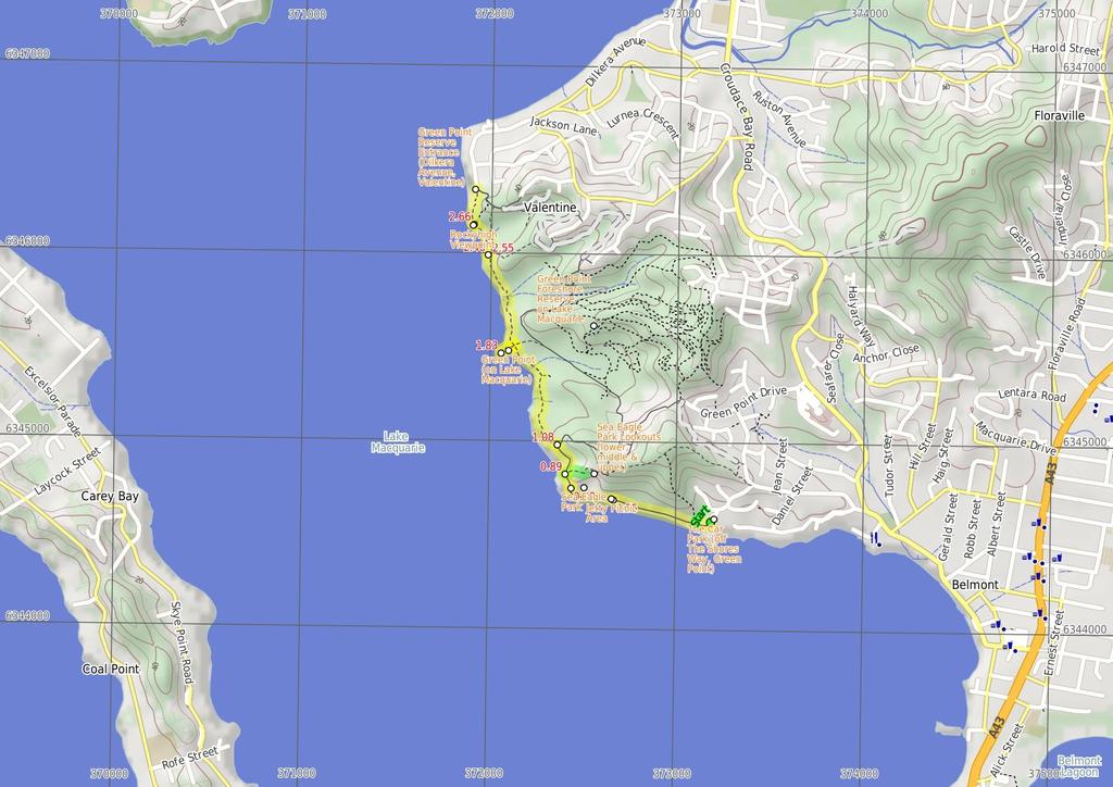
1 The Foreshore Walk 1 hr 15 mins 2.9 km One way Hard track 81m This walk traverses the coastline of the Green Point reserve. By following a variety of tracks and occasionally traveling inland through eucalyptus forest, this walk visits both Jetty and Sea Eagle picnic areas, Green Point itself and Rocky-high viewpoint. When looking into the waters of Lake Macquarie, keep a lookout for sea grass meadows and historical middens under the water. A thoroughly recommended walk, which will possibly require a car shuffle at the start of the walk. 4 Maps, text & images are copyright wildwalks.com Thanks to OSM, NASA and others for data used to generate some map layers. 1m Lake Macquarie LGA 24m

2 Green Point Foreshore Reserve on Lake Macquarie The Green Point Foreshore Reserve on Lake Macquarie is a great place for a bush walk, bicycle or picnic. The Green Point Foreshore reserve offers many historical and environmentally interpretative signs along its multi use pathways. There is an unformed foreshore pathway beside Lake Macquarie, or more physically demanding walks away from the lake foreshore and into rainforest. Historically, the Green Point area was involved in a coal rush from the 1860's. This coal rush was spearheaded by the Cardiff Coal Company. Coal was proposed to be transported by barge to Threlkeld's old wharf at Reid's Mistake (Swansea Heads) for shipping to Sydney. However, the coal was poor quality 'boiler coal' and used mostly for steamer boilers. This coal rush finished in Timber was also milled on site after the coal rush. The Lake Macquarie Council is undergoing extensive rehabilitation works to improve the area for recreation. For more information contact the Lake Macquarie Visitor Information Centre on (02) More info. The Car Park (off The Shores Way, Green Point) The Shores Way park entrance and car park is a great place to start a walk within the Green Point Foreshore Reserve on Lake Macquarie. The park entrance offers a toilet, a water tap, seating and plenty of car parking. There are attractive grass slopes here dropping into the water, that make a fine spot to have a picnic. Jetty Picnic Area The Jetty Picnic area in the Green Point Foreshore Reserve on Lake Macquarie offers a public jetty, a sheltered picnic table, seating, a drinking fountain and historical interpretative signs. The historical signs detail the 'timber getting' period of Green Point from 1860, with the timber used to build jetty's, pit prop for coal mining, ships and boats. There is also an historical sign detailing 'The Cardiff Coal Company', which mined coal out of Green Point during a minor coal rush. Before You walk Bushwalking is fun and a wonderful way to enjoy our natural places. Sometimes things go bad, with a bit of planning you can increase your chance of having an ejoyable and safer walk. Before setting off on your walk check 1) Weather Forecast (BOM Hunter District) 2) Fire Dangers (Greater Hunter) 3) Park Alerts () 4) Research the walk to check your party has the skills, fitness and equipment required 5) Agree to stay as a group and not leave anyone to walk solo Think before you TREK The 'Think before you TREK' program developed by NSW Police & NPWS promotes the benefits of planning ahead for your bushwalking trip by using an easy to remember acronym: T R E K Take adequate supplies of food, water, navigation and first aid equipment. Register your planned route and tell friends and family when you expect to return. Emergency beacon (PLB's) should be carried on walks with significant gaps in mobile coverage (check terrain profile). Keep to your planned route and follow the map and walking trails. Topo Maps The maps provided on wildwalks are helpful, but there are times where you may need maps covering a broader area. Maps that cover this walk include; 1: Map Series:92314N SWANSEA 1: Map Series:9231 LAKE MACQUARIE Grade This walk has been graded using the AS The overall grade of the walk is dertermined by the highest classification along the whole track. 4 Length Time Quality of track Grade 4/6 Hard track 2.9 km One way 1 hr 15 mins Formed track, with some branches and other obstacles (3/6) Signs Minimal directional signs (4/6) Experience Required Weather Infrastructure Some bushwalking experience recommended (3/6) Weather generally has little impact on safety (1/6) Limited facilities, not all cliffs are fenced (3/6) Sea Eagle Park Sea Eagle Park in Green Point Foreshore Reserve on Lake Macquarie is a large grassed picnic area, with a toilet, sheltered picnic tables, water from a tap and gas/electric barbeque's. This picnic area is particularly good for larger family group, for there is room to play ball games or just sit and look at the views. The short walk up to the Sea Eagle Lookouts is recommended for the commanding views south towards Swansea.
3 Are you ready to have fun? Please ensure you and your group are well prepared and equipped for all possible hazards and delays. Check park closures, weather information and Fire Danger Rating before setting out. Optional side trips and alternate routes noted are not included in this walks overall grade, length or time estimate. Please allow extra time for resting and exploring areas of interest. The authors, staff and owners of wildwalks take care in preparing this information but will not accept responsibility for any inconvenience, loss or injury you may experience. Please take care, have fun - Happy Walking. Getting there You can get to The Shores Way Car Park (gps: , ) by car or bus. Car: There is free parking available. You can get back from Int of Foreshore Track & Dilkera Ave Reserve Entrance (gps: , ) by car or bus. Car: There is free parking available. Find up to date and more information inlcuding; travel directions, weather, park closures and walker feedback at 0 Green Point Foreshore Reserve on Lake Macquarie The Green Point Foreshore Reserve on Lake Macquarie is a great place for a bush walk, bicycle or picnic. The Green Point Foreshore reserve offers many historical and environmentally interpretative signs along its multi use pathways. There is an unformed foreshore pathway beside Lake Macquarie, or more physically demanding walks away from the lake foreshore and into rainforest. Historically, the Green Point area was involved in a coal rush from the 1860's. This coal rush was spearheaded by the Cardiff Coal Company. Coal was proposed to be transported by barge to Threlkeld's old wharf at Reid's Mistake (Swansea Heads) for shipping to Sydney. However, the coal was poor quality 'boiler coal' and used mostly for steamer boilers. This coal rush finished in Timber was also milled on site after the coal rush. The Lake Macquarie Council is undergoing extensive rehabilitation works to improve the area for recreation. For more information contact the Lake Macquarie Visitor Information Centre on (02) More info. 0 The Car Park (off The Shores Way, Green Point) The Shores Way park entrance and car park is a great place to start a walk within the Green Point Foreshore Reserve on Lake Macquarie. The park entrance offers a toilet, a water tap, seating and plenty of car parking. There are attractive grass slopes here dropping into the water, that make a fine spot to have a picnic. 0 The Shores Way Car Park (550 m 10 mins) From the car park(on The Shores Way, Green Point), this walk heads towards the lake past the toilet block and along the footpath for 25m, to a four-way intersection with a 'Welcome to Green Point Foreshore Reserve' sign (on the right). Turn right: From the intersection, this walk follows the shared concrete cycle/footpath gently downhill, while keeping the Shores Way car park on your right and the water on your left. This walk continues, undulating for about 500m, until coming to the Jetty picnic area on the right and jetty on your left Jetty Picnic Area The Jetty Picnic area in the Green Point Foreshore Reserve on Lake Macquarie offers a public jetty, a sheltered picnic table, seating, a drinking fountain and historical interpretative signs. The historical signs detail the 'timber getting' period of Green Point from 1860, with the timber used to build jetty's, pit prop for coal mining, ships and boats. There is also an historical sign detailing 'The Cardiff Coal Company', which mined coal out of Green Point during a minor coal rush Jetty Picnic Area (Green Point Foreshore Reserve) (260 m 5 mins) Continue straight: From the Jetty Picnic Area, this walk follows the footpath gently uphill, while keeping the lake on your left. This walk continues for about 260m, until coming to a three-way intersection with a track and the Sea Eagle Park on your right. 0.8 Sea Eagle Park Sea Eagle Park in Green Point Foreshore Reserve on Lake Macquarie is a large grassed picnic area, with a toilet, sheltered picnic tables, water from a tap and gas/electric barbeque's. This picnic area is particularly good for larger family group, for there is room to play ball games or just sit and look at the views. The short walk up to the Sea Eagle Lookouts is recommended for the commanding views south towards Swansea. 0.8 Int of Foreshore Track & Sea Eagle Park (80 m ) Continue straight: From the intersection, this walk follows the footpath gently uphill, while keeping Sea Eagle Park on your right. This walk continues for about 70m, until coming to a three-way intersection with a track and 'Lookout' sign on your right and a 'Getting about at Green Point' sign on your left Optional sidetrip to Lower Lookout (Sea Eagle Park (110 m ) Turn right: From the intersection, this walk heads up timber steps, directly away from the face of the 'Getting about at Green Point' sign. This walk continues gently uphill, with occasional timber steps (and passing a seat) for about 110m, until coming to the Lower Lookout above Sea Eagle Park (on the right). At the end of this side trip, retrace your steps back to the main walk then Turn right Sea Eagle Park Lookouts (lower, middle & upper) These three lookouts (lower, middle and upper lookouts) are above Sea Eagle Park in Green Point Foreshore Reserve on Lake Macquarie and give great views across Lake Macquarie towards Swansea. The upper lookout has a picnic table in the shade behind the lookout, which gives relief on a hot day. The upper lookout also a picnic table at the lookout, offering fabulous views to the south. Each of these lookouts has a bench seat and interpretative signs. White Bellied Sea Eagles have been known to nest nearby and are often seen flying in the area Int of Foreshore AND Lookout Tracks (190 m 4 mins) Continue straight: From the intersection, this walk follows the 'Rainforest Boardwalk 1130m' sign and footpath gently downhill and keeping the 'Getting about at Green Point' sign on your left. This walk continues, undulating for about 180m, until coming to a three-way intersection, with a gently downhill gravel track on the right and the concrete footpath continuing to the right Int of Foreshore & Green Point Drive Tracks (750 m 14 mins) Turn left: From the intersection, this walk follows the gently downhill gravel track and timber steps, while leaving behind the concrete footpath and 'Green Point Drive' sign. This walk continues, undulating moderately steeply (ignoring side tracks) through open eucalyptus forest and with occasional short sections of timber boardwalk, for about 600m, until crossing over a timber footbridge by the lake and coming to the open grassy area of Green Point. Turn left: From the intersection, this walk follows the track towards Green Point (and the water), while leaving the forest directly behind you. This walk continues for about 60m, passing across grasslands and towards a small clump of She Oak trees, until coming to the lake edge and Green Point Green Point (on Lake Macquarie) Green Point in the Green Point Foreshore Reserve on Lake Macquarie is a large grassed area which looks out over Lake Macquarie. From the vantage point of Green Point, a walker can see up and down Lake Macquarie. There are often boats passing by this low headland. This is a fabulous place to have a picnic and there is even a clump of She Oak trees by the water for shade. There are no facilities here, other than the open grassed area Green Point (630 m 13 mins) Turn around: From Green Point (by the lake and small clump of She Oak trees), this walk follows the track across grasslands and towards the forest. This walk continues for about 60m, until coming to a fourway intersection with a track and forest ahead. Turn left: From the intersection, this walk follows the track, while keeping the lake and water on your left. This walk continues for about 210m, then passes over a timber boardwalk and bridge (with good views over the lake). Then this walk continues for about 160m through forest before climbing gently up and down timber steps. After a further 60m, this walk climbs gently up eroded timber steps, then after another 60m, comes to a track (on the right) as you are walking down timber steps Int of Fore Shore & Coast Tracks (90 m ) Continue straight: From the intersection, this walk follows the timber steps gently downhill, while keeping the lake on your left. This walk continues through forest for about 35m, to find a timber boardwalk and bridge (with views of the lake). Then this walk continues for about 20m, climbing up timber steps and following a track for a further about 50m, until coming to a three-way intersection, with a track and 'mangrove seed symbol' signed timber post (on the right) Int of Fore Shore AND Short Cut Tracks (120 m ) Veer left: From the intersection, this walk follows the track while initially keeping the 'mangrove seed symbol' signed timber post on the right and lake on the left. This walk continues for about 90m, undulating gently, to climb moderately steeply up timber steps (with a metal ring fence). This walk continues for 20m until coming to Rockyhigh Viewpoint, with a bench seat (on the right) and views over the lake (on the left) Rockyhigh Viewpoint The Rockyhigh Viewpoint (near Dilkera Avenue, Valentine) has elevated views across Lake Macquarie. There is a bench seat perfectly located to enjoy the views. This viewpoint is magnificent at sunset; a local secret Rockyhigh Viewpoint (210 m 4 mins) Continue straight: From Rockyhigh Viewpoint, this walk follows the track moderately steeply downhill (beside a metal ring fence), while keeping the water on your left. This walk continues for about 190m, undulating gently through forest, until coming to a T-intersection with a concrete footpath and 'Welcome to Green Point Fore Shore Reserve' sign (on the right)(dilkera Ave is visible directly ahead) Green Point Reserve Entrance (Dilkera Avenue, Vale The Dilkera Avenue entrance (in Valentine) to Green Point Foreshore Reserve offers access to both walking and bicycling paths. There is car parking and a large grassed park overlooking Lake Macquarie, a great spot to sit or have a picnic. A short walk away in the Green Point Reserve is Rockyhigh Viewpoint over Lake Macquarie, which is fabulous at sunset.
4
5 Powered by TCPDF ( Summary navigation sheet for the The Foreshore Walk km From Up/Dwn Length Initial directions (Use full tracknotes and maps for more detail) 0.00 The Shores Way Car Park , (GR Swansea, ) m 10 mins From the car park(on The Shores Way, Green Point), this walk heads towards the lake past the toilet block and along the footpath for 25m, to a four-way intersection with a 'Welcome to Green Point Foreshore Reserve' Jetty Picnic Area (Green Point Foreshore Reserve) , (GR Swansea, ) m 5 mins Continue straight: From the Jetty Picnic Area, this walk follows the footpath gently uphill, while keeping the lake on your left Int of Foreshore Track & Sea Eagle Park , (GR Swansea, ) m Continue straight: From the intersection, this walk follows the footpath gently uphill, while keeping Sea Eagle Park on your right Int of Foreshore & Lookout Tracks , (GR Swansea, ) m Optional sidetrip to Lower Lookout (Sea Eagle Park). Turn right: From the intersection, this walk heads up timber steps, directly away from the face of the 'Getting about at Green Point' sign Int of Foreshore AND Lookout Tracks , (GR Swansea, ) m 4 mins Continue straight: From the intersection, this walk follows the 'Rainforest Boardwalk 1130m' sign and footpath gently downhill and keeping the 'Getting about at Green Point' sign on your left Int of Foreshore & Green Point Drive Tracks , (GR Swansea, ) m 14 mins Turn left: From the intersection, this walk follows the gently downhill gravel track and timber steps, while leaving behind the concrete footpath and 'Green Point Drive' sign Green Point , (GR Swansea, ) m 13 mins Turn around: From Green Point (by the lake and small clump of She Oak trees), this walk follows the track across grasslands and towards the forest Int of Fore Shore & Coast Tracks , (GR Swansea, ) m Continue straight: From the intersection, this walk follows the timber steps gently downhill, while keeping the lake on your left Int of Fore Shore AND Short Cut Tracks , (GR Swansea, ) m Veer left: From the intersection, this walk follows the track while initially keeping the 'mangrove seed symbol' signed timber post on the right and lake on the left Rockyhigh Viewpoint , (GR Swansea, ) m 4 mins Continue straight: From Rockyhigh Viewpoint, this walk follows the track moderately steeply downhill (beside a metal ring fence), while keeping the water on your left.
Green Point Circuit Walk
 Green Point Circuit Walk 3 hrs 7.7 km Circuit Hard track 269m This walk visits all of the popular locations in Green Point Reserve, as well as some of the lesser-visited areas inland. Taking in Sea Eagle
Wallarah Coastal Walk
 Wallarah Coastal Walk 3 hrs 8.3 km Return Hard track 247m This walk starts at Caves Beach and travels south along the coastline, until reaching the Pinney s Headland Lookout. There are many opportunities
Hunters Hill to Epping Road
 Hunters Hill to Epping Road 2 hrs 30 mins 5.5 km One way Moderate track 154m An enjoyable walk through lower sections of the Lane Cove National Park, this walk features plenty of mangroves next to the
Morgans Creek to Padstow
 Morgans Creek to Padstow 2 hrs 45 mins 8 km One way Moderate track 3 144m This pleasant walk starts from the Morgans Creek park, at Henry Lawsons Drive, and follows the Georges River past the Boomerang
Currie Rd to Davidson Park
 Currie Rd to Davidson Park 3 hrs 7.2 km One way Moderate track 28m Starting at Currie Rd in Forestville, this walk follows Middle Harbour to Davidson Park, under Roseville Bridge. There are two optional
Echo Point to Leura Forest via Three Sisters and Giant Stairs loop
 Echo Point to Leura Forest via Three Sisters and Giant Stairs loop 3 hrs 3.8 km Circuit Hard track 512m This walk starts from the popular Echo Point, in Katoomba, and winds down to the base of the Three
Sid Pulsford Walk. 175m. 33m. 1 hr 45 mins 4.1 km One way. Hard track 118m. Gosford LGA
 Sid Pulsford Walk 1 hr 5 mins.1 km One way Hard track 118m Sid Pulsford Walk explores the ridge top of Kincumber Mountain, from Honeman's Rock to Green Point. The walk mostly follows wide management trails.
Teralba to Charlestown Park track head
 Teralba to Charlestown Park track head 4 hrs 30 mins 13.3 km One way Moderate track 3 220m This section of the Great North Walk starts from the Teralba train station and winds down and around the edge
Katoomba Falls Circuit
 Katoomba Falls Circuit hr 5 mins.5 km Circuit Hard track 59m For those looking for a walk involving more than simple boardwalk, this trail winding through the temperate rain forest could be just the thing.
Popes Glen, Pulpit Rock, Govetts Leap and Braeside Walk
 Popes Glen, Pulpit Rock, Govetts Leap and Braeside Walk 8 hrs Hard track 13.6 km Circuit 4 1068m This large circuit walk, from Popes Glen to Pulpit Rock, Govetts leap and along the Braeside Track, passes
Govetts Leap Loop. 1065m. 909m Blue Mountains National Park. 4 hrs 30 mins 8.7 km Circuit. Hard track 380m
 Govetts Leap Loop 4 hrs 30 mins 8.7 km Circuit Hard track 380m This walk, from Blackheath Train Station, is a fantastic way to see some of the iconic areas of the Blue Mountains in the Blackheath area.
Carrington Park to Leura Forest and pass loop
 Carrington Park to Leura Forest and pass loop 3 hrs Hard track 4.8 km Circuit 4 674m This walk is a fantastic way to see Leura Forest. The walk descends from Carrington Park, visiting Leura Forest and
Balmoral Beach to The Spit
 Balmoral Beach to The Spit 2 hrs 30 mins.3 km One way Hard track 85m This walks follows the coast from Balmoral to the Spit and across Spit Bridge. There are some alternate tracks to consider at high-tides,
Heathcote to Engadine via Audley
 Heathcote to Engadine via Audley 6 hrs 3 mins 5 km One way Hard track 4 635m Covering a large section of central Royal National Park, this walk goes through the heath and scrub along a well managed and
Epping to Pennant Hills Station (via Lane Cove River)
") Epping to Pennant Hills Station (via Lane Cove River) 3 hrs 5 mins 8.4 km One way Hard track 249m This walk, from Epping to Pennant Hills Station, is a great way to see the upper Lane Cove River Valley.
Epping to Pennant Hills Station (via Lane Cove River) 3 hrs 5 mins 8.4 km One way Hard track 249m This walk, from Epping to Pennant Hills Station, is a great way to see the upper Lane Cove River Valley.
Wattamolla to Big Marley Beach
 Wattamolla to Big Marley Beach 4 hrs 10.4 km Circuit Moderate track 4m This walk is an excellent loop which takes in both the coast and the heathy inland of Royal National Park. Nearly the whole walk has
Waterfall to Heathcote
 Waterfall to Heathcote 5 hrs Hard track 10.8 km One way 4 467m This walk explores the heart of Heathcote National Park, and is easily accessed with a train station at either end. Although relatively close
Little Digger Track. 68m. 1 Hr 2.2 km One way. Moderate track 93m. Moores Creek Reserve
 Little Digger Track Hr 2.2 km One way Moderate track 93m This walk follows Moores Creek through several reserves in east Roseville and East Lindfield. The track is named after Australia's 7th Prime Minster,
Campbell Drive to Snapper Point
 Campbell Drive to Snapper Point 1 hr 45 mins 4.2 km One way Experienced only 135m This walk follows the Coast Track to Frazer Beach, along the Geebung and (overgrown) Grass Tree Tracks. From the northern
Wentworth Falls Conservation Hut Loop
 Wentworth Falls Conservation Hut Loop 3 hrs Hard track 6.7 km Circuit 4 341m This scenic walk from Wentworth Falls Station, winds along the Nature Trail to Conservation Hut, then drops into the magnificent
Rail to River Walk. 3 hrs. Hard track 7.5 km Circuit. 222m
 Rail to River Walk 3 hrs Hard track 7.5 km Circuit 4 222m This walk is a great one from Chatswood Station to the Lane Cove River National Park. The walk descends through the vegetated bushland which fills
The Basin Track and Mackerel Track
 The Basin Track and Mackerel Track 3 hrs 5.9 km Circuit Hard track 226m This walk is a great way to see some popular areas in Ku-ring-gai Chase National Park. The walk from West Head Rd travels to The
Dead Horse Gap Loop track
 Dead Horse Gap Loop track 4 hrs 30 mins Hard track 9.8 km Circuit 144m 4 This walk starts with a ride up the Kosciuszko Express Chairlift. There is an opportunity to eat at Australia's highest restaurant,
Hornsby Blue Gum Walk
 Hornsby Blue Gum Walk 3 hrs Hard track 6.7 km Circuit 4 374m This delightful loop is one of the prettiest and most popular walks in the Hornsby area. Going from an environment of ferns and clear bushland
Epping to Eastwood Station (via Lane Cove River)
") Epping to Eastwood Station (via Lane Cove River) hrs 45 mins 10.2 km One way Moderate track 189m Epping to Eastwood, via Lane Cove River, is the longer route through the bush between the stations. This
Epping to Eastwood Station (via Lane Cove River) hrs 45 mins 10.2 km One way Moderate track 189m Epping to Eastwood, via Lane Cove River, is the longer route through the bush between the stations. This
Little Digger Track to Davidson Reserve and Lyrebird Circuit
 Little Digger Track to Davidson Reserve and Lyrebird Circuit 4 hrs 3 mins 11.5 km One way Hard track 4 47m Exploring both the eastern and western sides of Middle Harbour Creek, this walk follows the Little
Mackerel Beach, West Head Loop
 Mackerel Beach, West Head Loop 5 hrs 8.6 km Circuit Hard track 422m The Mackerel Beach, West Head Loop is a walk which explores a large part of the West Head. The journey starts and finishes with a ferry
Scenic World to Echo Point
 Scenic World to Echo Point 1 hr 15 mins 2.1 km One way Moderate track 192m This is one of the most popular tourist walks in the Katoomba area. The walk follows the cliffs along a well maintained and signposted
Rail to River and Stringybark Creek Reserve Walk
 Rail to River and Stringybark Creek Reserve Walk 4 hrs Hard track 11.2 km Circuit 4 302m This walk begins in the busy city of Chatswood and soon enters the nearby bushland around the Lane Cove River. The
Woolwich Wharf to Boronia Park
 Woolwich Wharf to Boronia Park 2 hrs 5.8 km One way Moderate track 175m Going through the streets of Hunters Hill, this walk is on the first segment of the Great North Walk. The majority of the walk is
Bouddi Coastal Walk. 5 hrs. Hard track 8.1 km One way. 364m
 Bouddi Coastal Walk 5 hrs Hard track 8.1 km One way 4 364m This is one of the longer walks in the Bouddi National Park and it is rich in scenery. The walk follows the coastline with many side trips to
Mackerel Beach and Resolute Loop
 Mackerel Beach and Resolute Loop 3 hrs 5.4 km Circuit Hard track 384m This walk is another great walk in Ku-ring-gai Chase National Park, accessed by ferry. From the Mackerel Beach wharf, this walk uses
Upper Rumbalara circuit
 Upper Rumbalara circuit 1 hr 30 mins 3.3 km Circuit Hard track 176m A great circuit walk, covering most of the walking tracks and sights in the upper section of the Rumbalara Reserve. There is some really
Sphinx, Warrimoo and Bobbin Head tracks
 Sphinx, Warrimoo and Bobbin Head tracks 4 hrs 9.6 km Circuit Moderate track 499m This great walk starts at the Sphinx Memorial and loops around via Cowan Creek, exploring diverse environments as it changes
Callicoma Loop. 174m. 98m. 2 hrs. Hard track 5.1 km Circuit. 153m
 Callicoma Loop 2 hrs Hard track 5.1 km Circuit 153m This great circuit walk passes through some really nice forest around the fringe of Cherrybrook. Highlights of the walk include some beautiful rock overhangs
Berowra to Mt Kuring-gai
 Berowra to Mt Kuring-gai 4 hrs 30 mins 9.4 km One way Hard track 4 551m From the ridges above Cowan Creek, this walk takes in some great lookouts (especially around Mt Kuringgai) as well as enjoying an
Taronga Wharf to Chowder Bay
 Taronga Wharf to Chowder Bay 2 hrs 4.4 km One way Moderate track 246m Starting at Taronga Wharf, this walk passes many icons of Sydney, including Taronga Zoo, HMAS Sydney Mast, Chowder Bay. The walk also
Spit Bridge to Middle Head Forts
 Spit Bridge to Middle Head Forts 2 hrs 30 mins 6.3 km One way Hard track 4 181m This scenic walk takes you from the Spit Bridge, along the coast to explore the Middle Head Forts. There are a few alternate
De Burgs Bridge to Thornleigh station
 De Burgs Bridge to Thornleigh station 3 hrs 45 mins 9.7 km One way Hard track 4 363m This walk follows a section of the Great North Walk, starting from De Burghs bridge. The walk winds north west, through
Patonga to Woy Woy. 5 hrs 45 mins 15.5 km One way. Hard track. 497m
 Patonga to Woy Woy 5 hrs 45 mins 15.5 km One way Hard track 4 497m This walk explores a variety of environments from the shore line and coastal cliffs near Patonga, to the dry, rocky and open ridge line.
De Burghs Bridge to Fullers Bridge
 De Burghs Bridge to Fullers Bridge 2 hrs 3 mins Hard track 6 km One way 2m 4 Following the Lane Cove River, this walk mostly follows a section of the Great North Walk and is well maintained and signposted.
Middle Harbour Creek Loop
 Middle Harbour Creek Loop 5 hrs 45 mins 15.1 km Circuit Experienced only 5 570m This walk explores the upper reaches of Middle Harbour Creek, starting and ending at the great parklands at Davidson Park,
Hermitage Foreshore Track
 Hermitage Foreshore Track 1 Hr 2.2 km One way Moderate track 123m The Hermitage Foreshore Walk is a wonderful way to explore Sydney Harbour from the perspective of South Head. This walk starts from Nielsen
Dubbo Gully and Ten Mile Hollow Circuit (via Clares Bridge)
") Dubbo Gully and Ten Mile Hollow Circuit (via Clares Bridge) 2 Days Hard track 24.3 km Circuit 4 1117m This two day (or ten hour) walk follows several historic roads, now closed to traffic. Starting with
Dubbo Gully and Ten Mile Hollow Circuit (via Clares Bridge) 2 Days Hard track 24.3 km Circuit 4 1117m This two day (or ten hour) walk follows several historic roads, now closed to traffic. Starting with
Under and Over Cliff Walk
 Under and Over Cliff Walk 4 hrs 9.4 km Circuit Moderate track 576m This walk from Wentworth Falls Station is a fantastic way to see a large majority of the Wentworth Falls cliffline. The track winds under
National Pass from Wentworth Falls to Conservation Hut
 National Pass from Wentworth Falls to Conservation Hut 3 hrs Hard track 3.6 km One way 739m Starting at Wentworth Falls picnic area, this scenic and historic walk explores many waterfalls, lookouts and
Federal Pass Walking Track
 Federal Pass Walking Track 5 hrs Hard track 8 km One way 4 989m This classic trail follows along the base of the cliffs from Leura to the Golden Stairs, passing many of the more popular sights of the Katoomba
Epping to Gordon Station
 Epping to Gordon Station 4 hrs 15 mins 11.7 km One way Hard track 4 365m This walk, from Epping Station to Gordon Station, passes below the homes which sit on the hills high above the Lane Cove River.
Blackheath Station to Junction Rock Loop (via Grand Canyon and Popes
 Blackheath Station to Junction Rock Loop (via Grand Canyon and Popes 8 hrs 30 mins 18.2 km Circuit Hard track 4 1254m This circuit starts in Blackheath and heads down into the Grand Canyon and Rodriguez
Charlestown Park trackhead to Newcastle station
 Charlestown Park trackhead to Newcastle station 5 hrs 30 mins 12.1 km One way Hard track 4 287m This section of the Great North Walk starts from the Charleston Park track head and winds through the streets
Roseville to Macquarie Park
 Roseville to Macquarie Park 3 hrs 3 mins 8.8 km One way Hard track 4 29m This walk starts at Roseville station and explores the streets and alleyways of Roseville before joining the main spine of the Great
Echo Point to Leura Forest Circuit
 Echo Point to Leura Forest Circuit 3 hrs 4.8 km Circuit Hard track 588m Forming a circuit around the cliffs and then the valley floor, this is a walk more then capable of convincing a walker of the beauty
Wentworth Falls Station Loop (Undercliff Walk)
") Wentworth Falls Station Loop (Undercliff Walk) 4 hrs 3 mins Hard track 8.9 km Circuit 658m 4 This walk passes some stunning waterfalls and views into the Jamison Valley, following the cliff edges around
Wentworth Falls Station Loop (Undercliff Walk) 4 hrs 3 mins Hard track 8.9 km Circuit 658m 4 This walk passes some stunning waterfalls and views into the Jamison Valley, following the cliff edges around
Gordon to Chatswood Station
 Gordon to Chatswood Station 4 hrs 30 mins 12.2 km One way Hard track 4 381m This walk is a great way to get into the bush without being far from civilisation. The walk wanders through untouched valleys
Sphinx to Mt Kuring-gai
 Sphinx to Mt Kuring-gai 4 hrs 45 mins 1.7 km One way Hard track 673m This walk starts at the Sphinx War Memorial and follows some well maintained and popular walking tracks down to Cowan Creek. Enjoy the
Thornleigh to Hornsby
 Thornleigh to Hornsby 4 hrs Hard track 10.2 km One way 4 526m Starting at Thornleigh station you walk through suburban streets for a short while before diving into the bush at the southern end of Berowra
Glenbrook and Euroka Circuit
 Glenbrook and Euroka Circuit 2 Days 16.6 km Circuit Experienced only 790m This two day circuit, returning to Glenbrook Station, is a scenic walk which passes many of the tourist attractions within the
North Ryde Fairyland circuit
 North Ryde Fairyland circuit 2 hrs 30 mins Hard track 6.9 km Circuit 193m 4 Starting at North Ryde train station this walk explores a stretch of the Lane Cove River, visiting the historic Fairlylands Pleasure
Gosford to Lisarow. 202m
 Gosford to Lisarow 4 hrs 3 mins Hard track 11.3 km One way 4 479m This walk is a great way to explore the ridge-top bushland between Gosford and Lisarow. Passing through Rumbalara and Katandra Reserves,
Spit Bridge to Manly (Manly Scenic Walkway)
") Spit Bridge to Manly (Manly Scenic Walkway) 3 hrs 45 mins 9.1 km One way Moderate track 349m The Spit to Manly walk is a classic bushwalk on Sydney's Northern Beaches. The walk follows a well-maintained
Spit Bridge to Manly (Manly Scenic Walkway) 3 hrs 45 mins 9.1 km One way Moderate track 349m The Spit to Manly walk is a classic bushwalk on Sydney's Northern Beaches. The walk follows a well-maintained
Lane Cove Tourist Park River Circuit
 Lane Cove Tourist Park River Circuit 5 hrs 12 km Circuit Hard track 383m This walk follows a large section of Lane Cove River. The walk follows the Riverside Walking track up the Lane Cove River to De
Bobbin Head Loop. 166m. 0m Ku-ring-gai Chase National Park. 5 hrs 12.9 km Circuit. Hard track 619m
 Bobbin Head Loop 5 hrs 12.9 km Circuit Hard track 619m This great circuit walk enjoys a variety of landscapes in Ku-ring-gai Chase National Park. The walk starts at the historic Sphinx war memorial and
Cape Banks Circuit. 50m. 2m Botany Bay National Park. 3 hrs 7.3 km Circuit. Hard track 190m
 Cape Banks Circuit 3 hrs 7.3 km Circuit Hard track 19m This Cape Banks Circuit has a lot to offer and is thoroughly recommended. The walking travels over beaches, through coastal forest and across exposed
Rumbalara Explorer. 158m. 5m Rumbalara Reserve. 2 hrs 45 mins 6.1 km Circuit. Hard track 326m
 Rumbalara Explorer 2 hrs 5 mins 6.1 km Circuit Hard track 326m Pretty well the grand tour of the Rumbalara Reserve, this walk takes in much of the great scenery the reserve has to offer. The walk covers
Wentworth Falls Loop. 893m. 665m. 6 hrs 10.2 km Circuit. Hard track 1093m. Blue Mountains National Park
 Wentworth Falls Loop 6 hrs 1.2 km Circuit Hard track 193m This is a great walk, both in size and spectacular views. The walk makes its way from Wentworth Falls train station and drops off the plateau,
Scenic world to Three Sisters Loop via Furber Steps
 Scenic world to Three Sisters Loop via Furber Steps 5 hrs 5.8 km Circuit Hard track 722m This walk starts from the popular Scenic World, in Katoomba, and winds down the Furber steps into the Jamison Valley,
Wentworth Falls Station Loop
 Wentworth Falls Station Loop 5 hrs 3 mins 9.5 km Circuit Hard track 4 13m The Wentworth Falls Station Loop takes in most of the upper tracks around Wentworth Falls. There are many scenic views near the
Narrabeen Lagoon Trail (from Middle Creek)
") Narrabeen Lagoon Trail (from Middle Creek) 2 hrs 30 mins 8.6 km Circuit Very easy 1 105m The Narrabeen Lagoon Trail is a wonderful and accessible walk on the Northern Beaches of Sydney. The trail is used
Narrabeen Lagoon Trail (from Middle Creek) 2 hrs 30 mins 8.6 km Circuit Very easy 1 105m The Narrabeen Lagoon Trail is a wonderful and accessible walk on the Northern Beaches of Sydney. The trail is used
Bouddi Ridge and Coastal Walk
 Bouddi Ridge and Coastal Walk 2 Days Hard track 27 km Circuit 4 126m This overnight walk takes in the majority of the magnificent Bouddi National Park. The walk starts from the pleasant Putty Beach camping
The Coast Track. 2 Days. Hard track 27.4 km One way. 1351m
 The Coast Track 2 Days Hard track 27.4 km One way 4 1351m Heading south, this walk covers the coastline of the Royal National Park and can truly only be described as amazing. With breathtaking coastal
Manly to Seaforth Oval
 Manly to Seaforth Oval 5 hrs 45 mins 13.7 km One way Moderate track 3 624m This walk follows the Manly to Spit Scenic Walkway, then continues past The Spit Bridge to Seaforth Oval. The walk provides magnificent
Taronga Zoo to Spit Bridge
 Taronga Zoo to Spit Bridge 5 hrs Hard track 1.4 km One way 4 41m This is a scenic and culturally rich walk with views over Sydney Harbour and many interesting heritage buildings along the way. The start
Chatswood to Epping Station
 Chatswood to Epping Station 6 hrs Hard track 16.3 km One way 4 533m This walk, from Chatswood to Epping, is a long but enjoyable walk along the Lane Cove valley. The walk mostly follows the Lane Cove River
Faulconbridge to Blaxland
 Faulconbridge to Blaxland 2 Days Experienced only 15.2 km One way 5 693m This two-day walk, or very solid one-day walk, takes you from station to station, through lush, scenic forest in the lower Blue
Light to Light Walk 2 days
 Light to Light Walk 2 days 2 Days Hard track 3.9 km One way 4 794m Over two days, this classic walk explores the coast from Boyd Tower to the Green Cape Lighthouse in the south. Hegartys Bay Camp is over
Six Foot Track. 1212m
 Six Foot Track 3 Days 44.8 km One way Hard track 4 2066m This classic walk takes you from Katoomba to Jenolan Caves via a historic horse route. The walk travels mainly along well-maintained service tracks
Harbour Bridge to Taronga Zoo
 Harbour Bridge to Taronga Zoo 4 hrs 9.8 km One way Moderate track 389m On this walk, you will explore much of the foreshore linking Milsons Point Station to Taronga Zoo Ferry wharf. The walk is mostly
Sydney to Thornleigh via Lane Cove Tourist Park
 Sydney to Thornleigh via Lane Cove Tourist Park 2 Days 33 km One way Hard track 4 1114m This overnight walk starts from the Obelisk in Macquarie Park, Sydney, at the official start of the Great North Walk.
RILLINGTON TO MALTON by Tania Dickinson
 RILLINGTON TO MALTON by Tania Dickinson This walk takes you from the Vale of Pickering up on to the Wold scarp, before dropping down again through the pretty village of Settrington and joining the Centenary
Beautiful Walks from the Blue Ball Inn
 Walk No. 7 COAST AND VALLEY WALK Countisbury, Glenthorne, County Gate, Brendon, Rockford and Wilsham 10 MILES APPROX. Walking time 5 hours approx. (not including breaks)> OS Sheet 64/74 Lynton and Lynmouth.
LDWA SOUTH DOWNS MARATHON 13 th MAY 2018
 AHD ahead SDW South Downs Way BL/BR bear left/bear right TL/TR turn left/turn right X cross LEG 1 - EAST DEAN to WP1 NORTON GR 470019. Open 1030 to 1300. 9.7 miles. 1.1 From village hall TL and walk to
Masson Hill. Walk. Approximately 4 km. Moderate Walk Begins from Matlock Railway Station
 Masson Hill Walk Approximately 4 km Moderate Walk Begins from Matlock Railway Station TOWN WALKS Masson Hill walk is approx. 4 km. It can be walked in a couple of hours or so. Enjoy your walk and the beautiful
SELF GUIDED TOURING ROUTE
 SELF GUIDED TOURING ROUTE Things to see and places to go on the loop from Orbost to Marlo, Cape Conran, Cabbage Tree and back to Orbost (or onwards to Cann River) V6 April 2017 This guide should be read
LDWA SOUTH DOWNS MARATHON
 AHD ahead SDW South Downs Way BL/BR bear left/bear right TL/TR turn left/turn right SP signpost/fingerpost X cross LEG 1 - EAST DEAN to WP1 NORTON GR 470019. Open 1030 to 1300. 9.6 miles. 1.1 From village
Portage Bay Park Design Commission Review 4: 90% Design Development January 5, 2017
 to be updated to reflect base bid condition Portage Bay Park Design Commission Review 4: 90% Design Development January 5, 2017 Previous Site Plan POTENTIAL PARK CONNECTION & MID-BLOCK CROSSING BOAT STREET
Tideswell to Castleton
 Tideswell to Castleton 1 Walk summary Length: 14 km, 8.5 miles Maps: OS Explorer OL1 The Peak District - Dark Peak Area, OS Explorer OL24 The Peak District - White Peak Area, OS Landranger 110 Sheffield
THE BECK STONE Backstone Beck on Ilkley Moor
 THE BECK STONE Backstone Beck on Ilkley Moor 1 Three different routes which take in the best of the lower slopes of Ilkley Moor, with bracken, heather, a tarn (a small mountain lake) and rushing streams.
NEWLANDS CORNER AND ST MARTHAS
 NEWLANDS CORNER AND ST MARTHAS 10k CIRCULAR ROUTE 2½-3HRS GU4 8SE From Newlands Corner on the North Downs just outside Guildford, you can enjoy one of the most beautiful panoramas of quintessential English
Heartwood Forest, in Sandridge, Hertfordshire, is a place where everyone can find space, peace, wildlife and miles of beautiful woodland to explore.
 Heartwood Forest Accessibility Statement September 2016 Purpose: This accessibility statement outlines the available facilities and access information for Heartwood Forest. Welcome We, the Woodland Trust,
10 Miles Circular 5 hours
 VISIT RYEDALE PICKERING AND CAWTHORN CAMPS 10 Miles Circular 5 hours Moderate Terrain 120616 A 10 mile (16km) there and back walk from the market town of Pickering in Ryedale. The route heads north through
Walk 7: Watchet to washford
 Walk 7: Watchet to washford Length: Moderate - 7.5 miles / 12 km Good For: Theme: History Duration: 2-3 hours depending on speed of walking Notes: This is a moderate to difficult walk in places, with steps,
Navigating Briones: getting around an advanced orienteering course. Brown Course, October 2011.
 Navigating Briones: getting around an advanced orienteering course. Brown Course, October 2011. The trek to the start this year wasn t short and boy was it steep. But this should be treated as an opportunity
MMT 100 Crew Instructions
 MMT 100 Crew Instructions Updated for the 2018 Event While crews are welcome at the MMT, they can cause congestion and related problems. Crews must comply with the provisions on this page. Race management
Welsh Newton and Woodland
 Welsh Newton and Woodland This is a 8.2km miles (approx) walk which will take about 2.5 hours at a relaxed and leisurely pace. There are a few hills but no steep inclines. Start at Llangrove bus stop and
VELINDRE VALLEYS WALK FOR STEFFAN
 VELINDRE VALLEYS WALK FOR STEFFAN IMPORTANT INFORMATION FOR WALKERS AND MARSHALS 1 Table of Contents Key Contact Numbers:... 3 Timetable and locations... 4 T-shirts... 4 Important Advice for Walkers...
Tonight is for you. Learn everything you can. Share all your ideas.
 Strathcona Neighbourhood Renewal Draft Concept Design Tonight is for you. Learn everything you can. Share all your ideas. What is Neighbourhood Renewal? Creating a design with you for your neighbourhood.
Loch Ness Shores Club Site
 Loch Ness Shores Club Site Camping and Caravanning Falls of Foyers Route Summary A strenuous walk from Loch Ness Shores Club Site. The route climbs through forest to The Upper Foyers Waterfall and then
HARDMOORS 26.2 WHITE HORSE HALF ROUTE DESCRIPTION - 018
 HARDMOORS 26.2 WHITE HORSE HALF ROUTE DESCRIPTION - 018 Follow Cleveland Way, keeping to the left hand path (right path is a bike trail) Ignoring any turnings to the left or right At path junction (after
COPE PARK MASTER PLAN
 COPE PARK MASTER PLAN CBJ Parks & Recreation Department is in the process of creating a Master Plan for the Cope Park Area. New restrooms are designated to be constructed in the park in the next year.
The North Pennines from near Langwathby
 3.6 Langwathby to Armathwaite Map panel?? Distance 12.7 miles (20.5 km) Terrain farm, woodland and riverside paths; some potentially muddy tracks; a few short sections of road Grade gently undulating Food