Magnolia Place. Traffic Impact Analysis. Prepared for: City of San Mateo. Prepared by: Hexagon Transportation Consultants, Inc.
|
|
|
- Melinda Joy Simmons
- 5 years ago
- Views:
Transcription
1 Magnolia Place Traffic Impact Analysis Prepared for: City of San Mateo Prepared by: Hexagon Transportation Consultants, Inc. Updated January 4, 2010
2 Table of Contents 1. Introduction Existing Conditions Approved Conditions Project Conditions Year 2020 Conditions Conclusion...23 Appendices Appendix A: Appendix B: Appendix C: Traffic Counts Level of Service Calculations Trip Generation Survey Data List of Tables Table 1 Level of Service Definitions at Signalized Intersections...3 Table 2 Level of Service Definitions at Unsignalized Intersections...4 Table 3 Intersection Levels of Service Under Existing Conditions...9 Table 4 Project Trip Estimates...12 Table 5 Intersection Levels of Service Under Project Conditions...15 Table 6 On-Street Parking Occupancy Survey Results...18 Table 7 Intersection Level of Service Under 2020 Cumulative Conditions...22 Table 8 Intersection Levels of Service Summary...24 List of Figures Figure 1 Site Location and Study Intersections...2 Figure 2 Existing Peak-Hour Traffic Volumes...8 Figure 3 Project Trip Distribution...13 Figure 4 Net Project Trip Assignment...14 Figure 5 Project Traffic Volumes...16 Figure With Project Traffic Volumes...21 Magnolia Place Final Traffic Analysis Report January 4, 2010 ii Hexagon Transportation Consultants, Inc.
3 1. Introduction This report presents the results of the traffic impact analysis conducted for the proposed Magnolia Place apartment development located on Tilton Avenue between Elm Street and North San Mateo Drive in San Mateo, California. The proposed project would replace 22 residential apartments with 52 residential apartments. Automobile access to the site would be provided to a three-level underground parking structure via a single driveway on Tilton Avenue. The location of the project site and the surrounding study area are shown on Figure 1. Scope of Study This study was conducted for the purpose of identifying the potential traffic impacts related to the proposed development. The impacts of the project were evaluated following the standards and methodologies set forth by the City of San Mateo. The traffic study includes an analysis of AM and PM peak-hour traffic conditions for three signalized intersections and one unsignalized intersection in the vicinity of the project site. The study intersections are identified below. Study Intersections Tilton Avenue and North El Camino Real East Poplar Avenue and North San Mateo Drive Tilton Avenue and North San Mateo Drive Tilton Avenue and Delaware Street (unsignalized) Traffic conditions at the intersections were analyzed for the AM and PM peak hours because it is during these periods that the project will have the greatest impact on traffic conditions. Magnolia Place Final Traffic Analysis Report January 4, Hexagon Transportation Consultants, Inc.
4
5 Analysis Scenarios Traffic conditions were evaluated for the following scenarios: Existing Conditions Year 2008 Project Conditions Existing Conditions plus the proposed project 2020 No Project Conditions Cumulative 2020 conditions without the project 2020 With Project Conditions Cumulative 2020 conditions with the project Analysis Methodologies and Level of Service Standards Traffic conditions were evaluated using level of service (LOS). Level of Service is a qualitative description of operating conditions ranging from LOS A, or free-flow conditions with little or no delay, to LOS F, or forced-flow conditions with extreme delays. A general description of level of service (LOS) is provided in Tables 1 and 2. Table 1 Level of Service Definitions at Signalized Intersections Average Level of Control Delay Service Description Per Vehicle (sec.) A Signal progression is extremely favorable. Most vehicles arrive during 10.0 or less the green phase and do not stop at all. Short cycle lengths may also contribute to the very low vehicle delay. B Operations characterized by good signal progression and/or short cycle 10.1 to 20.0 lengths. More vehicles stop than with LOS A, causing higher levels of average vehicle delay. C Higher delays may result from fair signal progression and/or longer cycle 20.1 to 35.0 lengths. Individual cycle failures may begin to appear at this level. The number of vehicles stopping is significant, though may still pass through the intersection without stopping. D The influence of congestion becomes more noticeable. Longer delays 35.1 to 55.0 may result from some combination of unfavorable signal progression, long cycle lengths, or high volume-to-capacity (V/C) ratios. Many vehicles stop and individual cycle failures are noticeable. E This is considred to be the limit of acceptable delay. These high delay 55.1 to 80.0 values generally indicate poor signal progression, long cycle lengths, and high volume-to-capacity (V/C) ratios. Individual cycle failures occur frequently. F This level of delay is considered unacceptable by most drivers. This Greater than 80.0 condition often occurs with oversaturation, that is, when arrival flow rates exceed the capacity of the intersection. Poor progression and long cycle lengths may also be major contributing causes of such delay levels. Source: Transportation Research Board, 2000 Highway Capacity Manual (Washington, D.C., 2000) p Magnolia Place Final Traffic Analysis Report January 4, Hexagon Transportation Consultants, Inc.
6 Table 2 Level of Service Definitions at Unsignalized Intersections Level of Average Delay Service Description of Operations Per Vehicle (Sec.) A Little or no traffic delay 10.0 or less B Short traffic delays 10.1 to 15.0 C Average traffic delays 15.1 to 25.0 D Long traffic delays 25.1 to 35.0 E Very long traffic delays 35.1 to 50.0 F Extreme traffic delays Greater than 50.0 Source: Transportation Research Board, 2000 Highway Capacity Manual (Washington, D.C., 2000) p17-2. Signalized Intersections Level of service at signalized intersections in the City of San Mateo is evaluated based on the average control delay for all movements at the intersection. The City of San Mateo has established mid-level LOS D (with an average delay of 45 seconds or less) as the minimum acceptable level at all signalized study intersections. Unsignalized Intersections At unsignalized intersections, level of service is based on the average delay for the controlled movements. The City of San Mateo has not established a level of service standard for unsignalized intersections. Significance Criteria The traffic impacts of the project are evaluated against the following criteria to determine whether the impacts are significant. City of San Mateo Level of Service Per the City s General Plan Policy C 2.7, all projects are required, at a minimum, to pay a transportation mitigation fee. The transportation mitigation fee is used to fund planned transportation improvements that are identified in the City of San Mateo Traffic Mitigation Program. In addition to paying the transportation impact fee, a development project may be required to fund off-site circulation improvements which are needed as a result of project generated traffic if: Magnolia Place Final Traffic Analysis Report January 4, Hexagon Transportation Consultants, Inc.
7 a) The acceptable level of service at a signalized intersection (mid-level LOS D with an average delay of more than 45 seconds) is exceeded by 4 seconds or more when the project traffic is added, and b) The intersection is subject to an increase in delay of 4 or more seconds, and c) The needed improvement of the intersection(s) is not funded in the applicable five-year City Capital Improvement Program from the date of application approval. The cost of the off-site improvements may be reimbursed by the City if a reimbursement program is established throughout the timeframe of the City of San Mateo s current Traffic Mitigation Program or at the time when the improvement was initially scheduled. The City of San Mateo has not established significance criteria for unsignalized intersections. Magnolia Place Final Traffic Analysis Report January 4, Hexagon Transportation Consultants, Inc.
8 2. Existing Conditions This chapter describes the existing conditions for all of the major transportation facilities in the vicinity of the site, including the roadway network, transit service, and bicycle and pedestrian facilities. Site Access and Surrounding Roadway Network Regional access to the site is provided via US 101. US 101 is an eight-lane north-south freeway in the vicinity of the site. US 101 extends northward through San Francisco and southward through San Jose. Access to the project site is provided via an interchange at E. Third Avenue. Local access to the site is provided via El Camino Real and Tilton Avenue. El Camino Real (SR 82) is a six-lane north-south major arterial in the vicinity of the site. El Camino Real extends from Santa Clara County through San Mateo County. El Camino Real provides access to the site via Tilton Avenue. Tilton Avenue is a two-lane east-west local street that extends from Amphlett Boulevard to El Camino Real in the west. West of El Camino Real, Tilton Avenue becomes El Cerrito Avenue. Tilton Avenue provides direct access to the site. Existing Bicycle and Pedestrian Facilities According to San Mateo County s Bike Trail System, there are numerous city-designated bikeways within the vicinity of the project site. Magnolia Place Final Traffic Analysis Report January 4, Hexagon Transportation Consultants, Inc.
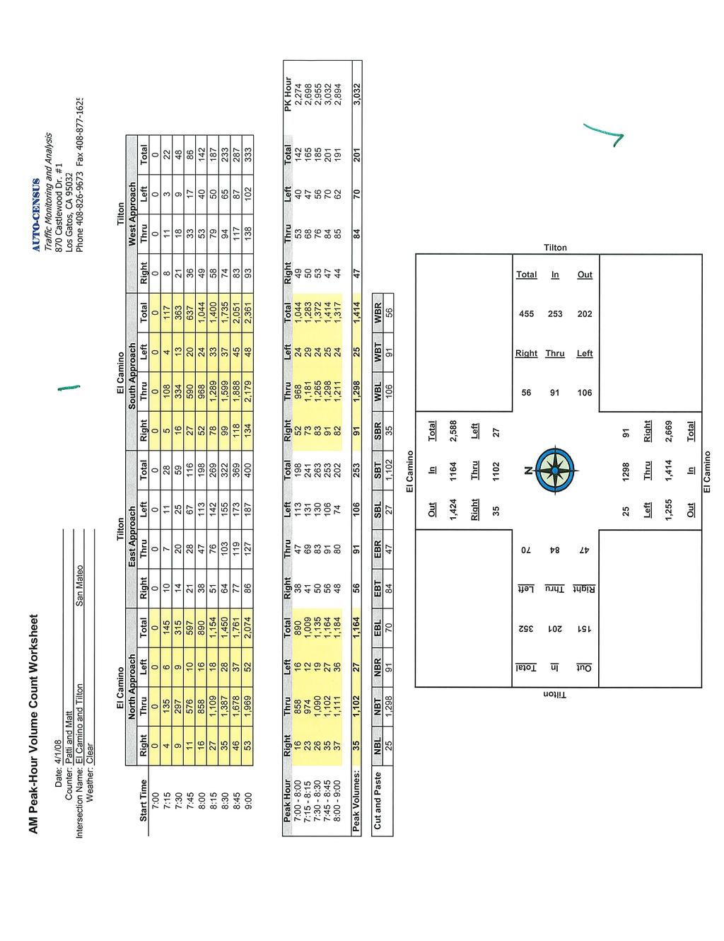
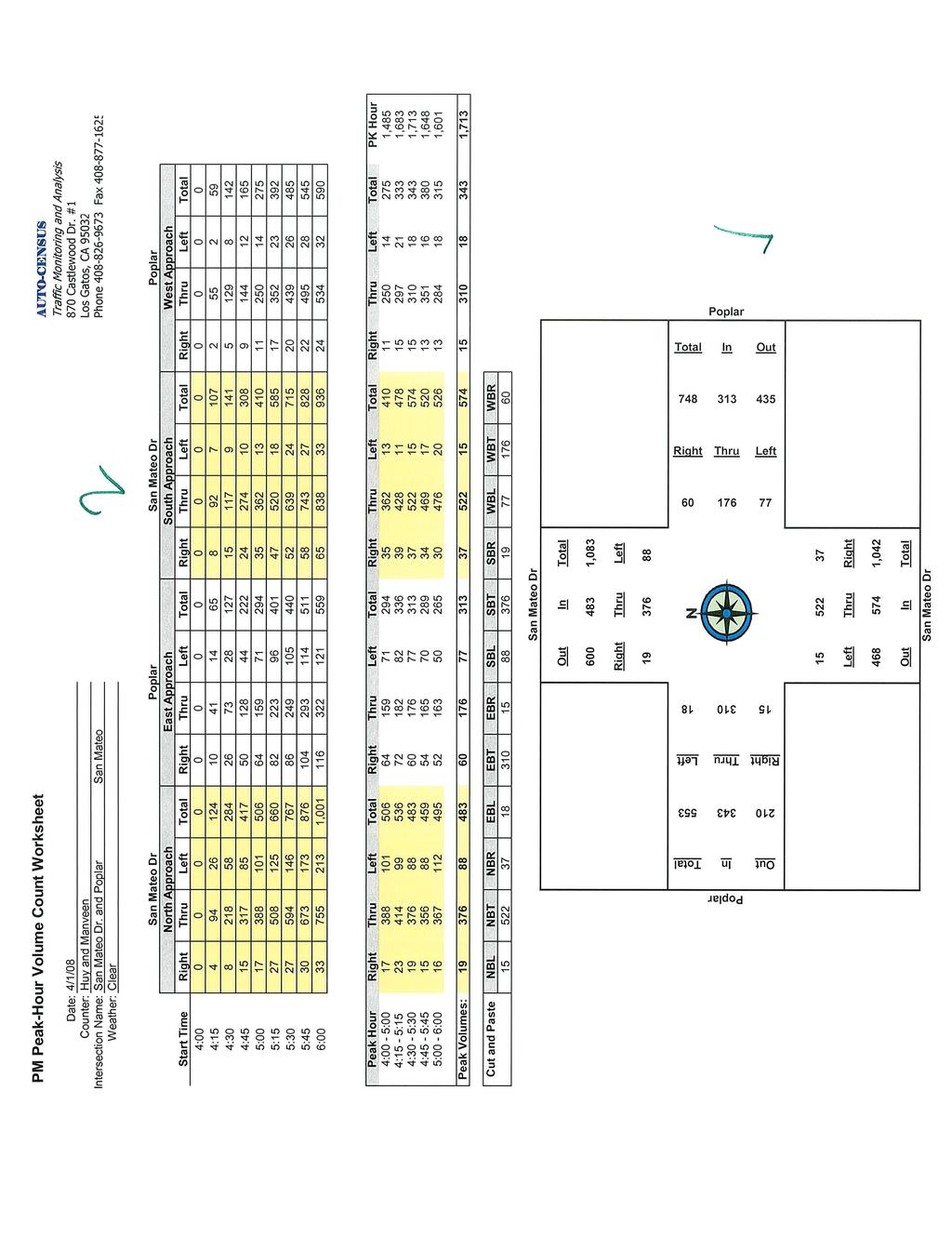
9 The following streets in the project area have bicycle lanes: Third Avenue, Fourth Avenue, Delaware Street, San Mateo Drive, El Camino Real, and Tilton Avenue (west of North San Mateo Drive) Pedestrian facilities near the site consist of sidewalks along all streets in the area including the site frontage on Tilton Avenue. Existing Transit Service Existing transit service to the study area is provided by the San Mateo County Transit District (SamTrans) and Caltrain. These are described below. SamTrans Bus Service There are two bus lines that operate near the project site. The 250 line provides service between the San Mateo Caltrain Station and the College of San Mateo via Fourth Avenue, San Mateo Drive, and Delaware Street with approximately 30-minute headways during the weekday AM and PM commute hours. The 55 line provides service between San Mateo Park and Borel Square via El Camino Real and Poplar Avenue. This route operates with only one trip during the AM peak commute hours and two midday trips. There are no trips on this line during the PM peak commute hours. Caltrain Service Commuter rail service between San Francisco and Gilroy is provided by Caltrain. The project is located approximately 0.4 miles northwest of the San Mateo Caltrain station. The San Mateo Caltrain station is located near the intersection of B Street and Baldwin Avenue. Caltrain provides service with approximately 20- to 30-minute headways during the weekday AM and PM commute hours. Existing Traffic Volumes The existing peak-hour intersection volumes were obtained from traffic counts conducted in The existing traffic volumes are shown on Figure 2. The new traffic counts conducted for this study are included in Appendix A. Existing Levels of Service The results of the level of service analysis under existing conditions are summarized in Table 3. The results show that all of the signalized study intersections currently operate within the adopted level of service standard. The unsignalized intersection of Tilton Avenue and Delaware Street currently operates at LOS B during both peak hours. The level of service calculation sheets are included in Appendix B. Magnolia Place Final Traffic Analysis Report January 4, Hexagon Transportation Consultants, Inc.
10
11 Table 3 Intersection Levels of Service Under Existing Conditions Peak Count Avg. Intersection Hour Date Delay a LOS b E. Poplar Avenue and N. San Mateo Drive AM 04/01/ B PM 04/01/ B Tilton Avenue and El Camino Real AM 04/01/ B PM 04/01/ B Tilton Avenue and N. San Mateo Drive AM 04/01/ A PM 04/01/ A Tilton Avenue and Delaware Street* AM 04/02/ B PM 04/02/ B * Denotes unsignalized intersection (4-way stop). a Average control delay (seconds per vehicle) including all movements for intersections controlled by a signal or four-way stop. b Level of service (based on average delay). Magnolia Place Final Traffic Analysis Report January 4, Hexagon Transportation Consultants, Inc.
12 3. Approved Conditions Hexagon completed a trip generation study for proposed condominium projects located at 117 and 121 North San Mateo Drive, 201 North San Mateo Drive, and Monte Diablo Avenue in San Mateo, California. These sites are located in reasonably close proximity to each other. The proposed projects are located on sites with existing uses that would be removed. Therefore, the trips generated by the existing uses were subtracted from the trips that would be generated by the proposed new homes. The trip generation study showed that the proposed projects would generate an estimated 14 net new trips in the AM peak hour and an estimated net reduction of 10 trips during the PM peak hour. Due to the small amount of new vehicle trips generated by these proposed developments and the parking supply in the project vicinity, the approved projects will not have a significant impact on the on-street parking. Magnolia Place Final Traffic Analysis Report January 4, Hexagon Transportation Consultants, Inc.
13 4. Project Conditions Project conditions are represented by Existing Conditions (since there are no approved developments) with the addition of traffic generated by the project and include any project-related transportation improvements. The proposed project is located at , and 120 Tilton Avenue in San Mateo, California. The proposed project would replace 22 residential apartments with 52 residential apartments, including 27 one-bedroom units, 11 two-bedroom units (under 1,400 s.f.),12 two-bedroom units (over 1,400 s.f.), and 2 three-bedroom units. Automobile access to the site will be provided to a three-level underground parking structure via a single driveway on Tilton Avenue. The project applicant is providing 115 parking spaces in the structure. The garage would provide 57 standard parking spaces, 43 compact spaces, 4 handicapped spaces, and 11 guest parking spaces (includes 1 van accessible handicapped space). Project Trip Generation The trips generated by the existing land uses were surveyed on Wednesday, April 2, 2008 from 7:00-9:00 AM and from 4:00-6:00 PM. The trip generation survey consisted of a count of the number of vehicles entering and exiting the site driveways. The peak hours within these periods were identified and the hourly trip generation rates were derived. The survey data are provided in Appendix C. Existing Use The existing apartments generated approximately 7 vehicle trips during the AM peak hour and 2 vehicle trips during the PM peak hour. The daily traffic generated by the existing apartments was extrapolated from the observed peak-hour trips. A comparison of apartment trip rates published in the ITE Trip Generation manual shows that daily trips on a weekday typically equal approximately 10 times the number of PM peak-hour trips on a weekday. The existing use is therefore estimated to generate 20 vehicle trips on an average weekday. Magnolia Place Final Traffic Analysis Report January 4, Hexagon Transportation Consultants, Inc.
14 Proposed Use The magnitude of traffic added to the roadway system by the project was estimated by multiplying the applicable trip generation rates to the size of the development. Trip generation for the proposed project was estimated using the rates published in ITE s Trip Generation, Seventh Edition, This manual is the industry standard for trip generation analysis in the United States. The published rates are based on data collected from hundreds of studies conducted to date for projects with land uses similar to the uses proposed for this project. These rates are generally recommended for use in a study of this type. The proposed residential apartments are estimated to generate 349 daily vehicle trips including 26 vehicle trips in the AM peak hour and 32 vehicle trips in the PM peak hour. After applying existing trip credits, the proposed project is estimated to generate a net increase of 19 AM peak-hour trips and 30 PM peakhour trips. The daily and peak-hour vehicle trips generated by the existing land use and the proposed residential apartments are shown in Table 4. Table 4 Project Trip Estimates AM Peak Hour PM Peak Hour Daily Daily Peak-Hour Peak-Hour Site / Land Use Size 1 Rate Trips Rate In Out Total Rate In Out Total Magnolia Place Proposed Project Apartments 2 52 units Existing Uses Apartments 3 (22) units 0.91 (20) 0.32 (0) (7) (7) 0.09 (2) (0) (2) Net New Trips Generated Size expressed in dwelling units. 2 Trip rates (per dwelling unit) based on Institute of Transportation Engineers, Trip Generation, Seventh Edition, Apartment (220) 3 Trip rate per dwelling unit. Source: Magnolia Place Trip Generation Survey, Wednesday, 4/2/ AM and 4-6 PM. Daily trips estimated based on peak-hour volumes. Project Trip Distribution and Assignment The trip distribution pattern for the proposed development was estimated based on existing travel patterns on the surrounding roadway system, the locations of complementary land uses, and previous traffic studies for similar developments in the study area. The trip distribution pattern for the proposed project is shown on Figure 3. The peak-hour trips generated by the proposed project were assigned to the roadway system using the TRAFFIX software and in accordance with the appropriate trip distribution patterns. The net project trip assignment (proposed less existing trips) is shown on Figure 4. Magnolia Place Final Traffic Analysis Report January 4, Hexagon Transportation Consultants, Inc.
15
16
17 Project Traffic Volumes and Level of Service The project trips, estimated as described above, were added to Existing traffic volumes to obtain Project traffic volumes. The project traffic volumes are shown on Figure 5. Traffic conditions at the study intersections were evaluated using level of service. The intersection levels of service for Project Conditions are summarized in Table 5. The results show that all of the signalized study intersections would operate within the adopted level of service standard. The unsignalized intersection of Tilton Avenue and Delaware Street would continue to operate at LOS B during both peak hours Table 5 Intersection Levels of Service Under Project Conditions Existing Project Conditions Peak Avg. Avg. Incr. In Intersection Hour Delay a LOS b Delay a LOS b Avg. Delay E. Poplar Avenue and N. San Mateo Drive AM 10.1 B 10.1 B 0.0 PM 10.1 B 10.1 B 0.0 Tilton Avenue and El Camino Real AM 14.8 B 15.2 B 0.4 PM 13.7 B 13.9 B 0.2 Tilton Avenue and N. San Mateo Drive AM 9.6 A 9.6 A 0.0 PM 9.2 A 9.3 A 0.1 Tilton Avenue and Delaware Street* AM 12.3 B 12.3 B 0.0 PM 13.3 B 13.4 B 0.1 * Denotes unsignalized intersection (4-way stop). a Average control delay (seconds per vehicle) including all movements for intersections controlled by a signal or four-way stop. b Level of service (based on average delay). Project Impacts on Bicycle and Pedestrian Facilities It is reasonable to assume that bicycle trips will comprise no more than two percent of the travel mode share to the site. Based on the gross trips generated by the proposed residential apartment development, the project is estimated to generate at most one bicycle trip during either the AM or PM peak hour. As a result, no new bicycle facilities would be required. It is reasonable to assume that pedestrian trips will comprise no more than ten percent of the travel mode share (including the share that walk to transit) to the site. Thus, the proposed residential apartment development is estimated to generate 2 pedestrian trips during the AM peak-hours and 3 pedestrian trips during the PM peak-hours. These volumes of pedestrian trips are not expected to exceed the carrying capacity of sidewalks along the site frontage or of sidewalks on streets surrounding the site. Thus, the project-generated pedestrian trips are not expected to require new sidewalks. The existing sidewalks should be adequate to accommodate all pedestrian traffic on and around the project site. Magnolia Place Final Traffic Analysis Report January 4, Hexagon Transportation Consultants, Inc.
18
19 Project Impacts on Transit Service Although no deduction for transit usage was applied to the estimated vehicular trip generation for the project, there is likely to be some transit and Caltrain use by residents. Assuming a transit mode share of 5 percent, the new development would generate one transit rider during the AM peak hour and two transit riders during the PM peak hour. Given that two bus routes and Caltrain serve the site, these riders could be accommodated by the existing service. Transportation Management Association The City of San Mateo is working on establishing a transportation management association (TMA) for the downtown San Mateo area. Once formed, the TMA will look at transportation demand management (TDM) measures for the downtown area. Since the TMA has not been formed yet, the project cannot immediately implement any TDM measures. However, once the TMA has been established, the proposed project should participate in the TMA. Recommendation 1: established by the City. The owner/applicant shall participate in the downtown TMA once it has been Congestion Management Program The project would add traffic to SR 82 (El Camino Real) a CMP roadway. CMP guidelines specify that a project must implement travel demand management (TDM) measures if the project produces 100 or more new peak-hour trips on CMP roadways. Since the project would produce fewer than 100 trips on CMP roadways in either peak hour, it would not have a CMP impact. Parking Based on the City of San Mateo s Zoning Ordinance, the proposed project would be required to provide parking at the following rates: One-Bedroom = 1.8 spaces per unit (1.6 spaces for residents and 0.2 spaces for visitors) Two-Bedroom (under 1,400 s.f.) = 2.0 spaces per unit (1.8 spaces for residents and 0.2 spaces for visitors) Two-Bedroom (over 1,400 s.f.) = 2.2 spaces per unit (2.0 spaces for residents and 0.2 spaces for visitors) The proposed project contains 27 one-bedroom units, 11 two-bedroom units (under 1400 s.f.), 12 twobedroom units (over 1400 s.f.), and 2 three-bedroom units. Based on these rates, the proposed project would require 102 parking spaces, 91 for residents and 11 for visitors. On-Site Parking The project applicant is providing 115 parking spaces in a three-level underground parking structure. The garage would provide 57 standard parking spaces, 43 compact spaces, 4 handicapped spaces, and 11 guest parking spaces (includes 1 van accessible handicapped space).the applicant is also providing bicycle parking on the upper level of the parking structure and bicycle storage on the lower level. Magnolia Place Final Traffic Analysis Report January 4, Hexagon Transportation Consultants, Inc.
20 On-Street Parking As part of the traffic impact analysis for this project, Hexagon conducted a parking occupancy survey on the residential streets surrounding the project site. The survey was done on Tuesday, May at 11:00 PM to capture the highest residential parking demand. Based on widely accepted traffic engineering knowledge, the peak parking demand is late in the night on weeknights. The parking survey was conducted at this time in order to assess the worst-case parking scenario to be conservative for this study. The survey included streets generally bounded by El Camino Real, Monte Diablo Avenue, the railroad and St. Matthews Avenue/Baldwin Avenue. See Table 6 for the parking occupancy results. Table 6 On-Street Parking Occupancy Survey Results Street Total Spaces Vehicles Parked Percent Occupied El Camino Real % Ellsworth Avenue % Baldwin Avenue % N. San Mateo Drive % Monte Diablo % Tilton Avenue % Catalpa Street % Elm Street % B Street % Total: Average: 54% The survey area, which is within approximately one-third of a mile walking distance from the project site, has a total of 590 on-street parking spaces. The survey found an average occupancy rate of 54 percent. Thus, a total of 289 on-street spaces are currently unoccupied at night when the project would have its peak parking demand. The project would result in the removal of 6 existing on-street parking spaces on Tilton Avenue along the site frontage. This area will be restriped with a combination of red and yellow curb for a fire lane and a loading zone. The removal of 6 on-street parking spaces would not create an issue based on the current curb space utilization and the proposed 13 surplus parking spaces as part of the project. It is therefore concluded that ample on-street parking would be available to accommodate any parking overflow in excess of the City s parking requirements. Parking Impacts It is concluded that adequate parking would be provided by the project applicant. Thus, the project s impact on parking would be considered less than significant. Magnolia Place Final Traffic Analysis Report January 4, Hexagon Transportation Consultants, Inc.
21 Construction Impacts Haul Routes During construction it will be necessary to haul construction materials to the site. It is desirable to limit the amount of hauling in residential areas. It is Public Works policy for trucks to use the City of San Mateo Municipal Code (SMMC) designated haul routes whenever possible and to use other arterials and collectors when necessary between the designated haul roads and the project site, with the intent of causing the least amount of impact to residential streets and areas. Recommendation 2: Haul routes shall be limited to U.S. 101, El Camino Real, and Highway 92 per the San Mateo Municipal Code. Construction Worker Parking Initially, construction workers will park on the project site. During early construction phases, there will be approximately five personnel vehicles that will utilize 160 feet of street property frontage as necessary. At the peak of construction, the maximum number of personnel vehicles anticipated is 20. The site s parking needs and storage needs during the later phases of construction will be accommodated in the below-grade parking garage. Hexagon recommends that a construction worker parking plan be provided prior to issuance of permits to reduce impacts to street parking for residents in the neighborhood. Recommendation 3: Prior to any issuance of permits, the applicant shall submit a construction worker parking plan to reduce impacts to street parking for residents in the neighborhood. Magnolia Place Final Traffic Analysis Report January 4, Hexagon Transportation Consultants, Inc.
22 5. Year 2020 Conditions Year 2020 traffic conditions were evaluated for the AM and PM peak hours. The 2020 peak-hour traffic volumes at two of the signalized study intersections (El Camino Real at Tilton Avenue and San Mateo Drive and Poplar Avenue) were obtained from the City of San Mateo Travel Model Data. The 2020 volumes at these two intersections were compared with the existing volumes and growth factors were derived for the AM and PM peak hours. The growth factors were then applied to the other two study intersections. The 2020 forecast volumes obtained from these sources were used to represent 2020 cumulative conditions with the project since this project is represented in the 2020 General Plan (GP) land use data set. The project trips, determined as described in the previous chapter, were subtracted from the model-forecast volumes to represent 2020 cumulative conditions without the project. The 2020 AM and PM peak-hour volumes with the project are shown on Figure Levels of Service The intersection levels of service under 2020 Cumulative Conditions are summarized in Table 7. The results show that one of the signalized study intersections (El Camino Real and Tilton Avenue) and the unsignalized study intersection (Tilton Avenue and Delaware Street) would drop to LOS F under 2020 Cumulative Conditions both without and with the project in both peak hours. The City of San Mateo is collecting traffic mitigation fees toward an improvement at the El Camino Real/Tilton Avenue intersection that would maintain acceptable levels of service through the Year According to the City of San Mateo s significance criteria, the project will have a significant impact on the cumulative levels of service at the signalized study intersections. The mitigation fees also will fund up to 20 new traffic signals as warranted. While the 2020 traffic forecasts at the Tilton/Delaware intersection warrant signalization, the City will continue to assess for the need for signalization at each intersection as time passes based on actual development intensities, locations and future travel patterns. The level of service calculation sheets are included in Appendix B. Impact: Mitigation: The project will contribute to the growth in cumulative traffic demand. The project will be required to pay Traffic Impact Fees based on the cumulative traffic increase. Magnolia Place Final Traffic Analysis Report January 4, Hexagon Transportation Consultants, Inc.
23
24 Table 7 Intersection Level of Service Under 2020 Cumulative Conditions Without Project With Project Peak Avg. Avg. Incr.In Intersection Hour Delay a LOS b Delay a LOS b Avg. Delay E. Poplar Avenue and N. San Mateo Drive AM 11.2 B 11.2 B 0.0 PM 11.1 B 11.2 B 0.1 Tilton Avenue and N. El Camino Real AM F F 5.3 PM F F 3.2 Tilton Avenue and N. San Mateo Drive AM 12.2 B 12.4 B 0.2 PM 15.6 B 15.9 B 0.3 Tilton Avenue and Delaware Street* AM 70.7 F 70.9 F 0.2 PM F F 0.7 * Denotes unsignalized intersection (4-way stop). a Average control delay (seconds per vehicle) including all movements for intersections controlled by a signal or four-way stop. b Level of service (based on average delay). Magnolia Place Final Traffic Analysis Report January 4, Hexagon Transportation Consultants, Inc.
25 6. Conclusion The project would cause no significant impacts at the signalized intersections evaluated in this study. The project trips will not substantially change the delay at the unsignalized study intersection. However, the project would, as a result of its contribution to cumulative increases in traffic, be required to pay its fair share to the City of San Mateo Traffic Impact Fee. Off-Site Impacts and Mitigation Impact: Mitigation: The project will contribute to the growth in cumulative traffic demand. The project will be required to pay Traffic Impact Fees based on the cumulative traffic increase. The intersection levels of service for all study scenarios are shown in Table 8. Off-Site Recommendations Recommendation 1: established by the City. The owner/applicant shall participate in the downtown TMA once it has been Recommendation 2: Haul routes shall be limited to U.S. 101, El Camino Real, and Highway 92 per the San Mateo Municipal Code. Recommendation 3: Prior to any issuance of permits, the applicant shall submit a construction worker parking plan to reduce impacts to street parking for residents in the neighborhood Magnolia Place Final Traffic Analysis Report January 4, Hexagon Transportation Consultants, Inc.
26 Table 8 Intersection Levels of Service Summary 2020 Cumulative Conditions Existing Project Conditions Without Project With Project Peak Count Avg. Avg. Incr. In Avg. Avg. Incr.In Hour Date Delay a LOS b Delay a LOS b Avg. Delay Delay LOS b Delay a LOS b Avg. Delay E. Poplar Avenue and N. San Mateo Drive AM 4/1/ B 10.1 B B 11.2 B 0.0 PM 4/1/ B 10.1 B B 11.2 B 0.1 Tilton Avenue and N. El Camino Real AM 4/1/ B 15.2 B F F 5.3 PM 4/1/ B 13.9 B F F 3.2 Tilton Avenue and N. San Mateo Drive AM 4/1/ A 9.6 A B 12.4 B 0.2 PM 4/1/ A 9.3 A B 15.9 B 0.3 Tilton Avenue and Delaware Street* AM 4/2/ B 12.3 B F 70.9 F 0.2 PM 4/2/ B 13.4 B F F 0.7 * Denotes unsignalized intersection (4-way stop). a b Average control delay (seconds per vehicle) including all movements for intersections controlled by a signal or four-way stop. Level of service (based on average delay). Magnolia Place Hexagon Transportation Consultants, Inc. Draft Traffic Analysis Report January 4,
27 Magnolia Place Traffic Analysis Report Technical Appendices January 4, 2010 Magnolia Place Final Traffic Analysis Report January 4, Hexagon Transportation Consultants, Inc.
28 Appendix A Traffic Counts Magnolia Place Final Traffic Analysis Report January 4, Hexagon Transportation Consultants, Inc.
29
30
31
32
33
34
35
36
37 Appendix B Level of Service Calculations Magnolia Place Final Traffic Analysis Report January 4, Hexagon Transportation Consultants, Inc.
38
39
40
41
42
43
44
45
46
47
48
49
50
51
52
53
54
55
56
57
58
59
60
61
62
63
64
65
66
67
68
69
70
71
72
73
74
75
76
77
78 Appendix C Trip Generation Survey Data Magnolia Place Final Traffic Analysis Report January 4, Hexagon Transportation Consultants, Inc.
79
80
Mission Street Medical Office Development
 reet Medical Office Development Traffic Impact Analysis Prepared for: Palo Alto Medical Foundation February 23, 2012 Hexagon Office: 7888 Wren Avenue, Suite B121 Gilroy, CA 95020 Hexagon Job Number: 11RD11
D.13 Transportation and Traffic
 This section addresses transportation and traffic issues and impacts related to the Proposed Project. Section D.13.1 provides a description of the affected environment for the Proposed Project. Applicable
HENDERSON DEVELOPMENT 213, 217, 221, 221 ½, 223 HENDERSON AVENUE and 65 TEMPLETON STREET OTTAWA, ONTARIO TRANSPORTATION OVERVIEW.
 HENDERSON DEVELOPMENT 213, 217, 221, 221 ½, 223 HENDERSON AVENUE and 65 TEMPLETON STREET OTTAWA, ONTARIO TRANSPORTATION OVERVIEW Prepared for: 2294170 Ontario Inc. February 2, 2017 117-652 Report_1.doc
TABLE OF CONTENTS TABLE OF CONTENTS... I APPENDICES... III LIST OF EXHIBITS... V LIST OF TABLES... VII LIST OF ABBREVIATED TERMS...
 TABLE OF CONTENTS TABLE OF CONTENTS... I APPENDICES... III LIST OF EXHIBITS... V LIST OF TABLES... VII LIST OF ABBREVIATED TERMS... IX 1 INTRODUCTION... 1 1.1 Project Overview... 1 1.2 Analysis Scenarios...
B. TRANSPORTATION, CIRCULATION AND PARKING
 FEBRUARY 0 89 EL CAMINO REAL PROJECT EIR This section describes the existing traffic, circulation, parking, and transit conditions in the vicinity of the project site and provides an analysis of the project
4.3 TRAFFIC. Introduction. Approach and Methodology
 4.3 TRAFFIC Introduction This section summarizes a transportation study conducted for the proposed Corridor Plan and the Bay Meadows project prepared by Hexagon Transportation Consultants, Inc. 1 Copies
TRAFFIC ACTION PLAN. North Central Neighborhood CITY OF SAN MATEO
 TRAFFIC ACTION PLAN North Central Neighborhood CITY OF SAN MATEO Draft February 2017 Table of Contents Introduction... 1 The Traffic Forum Process... 4 Neighborhood Traffic Issues... 6 Neighborhood Recommendations
III. Circulation A. INTRODUCTION
 III. Circulation A. INTRODUCTION The City is striving toward making it convenient for many residents to travel to work, obtain services, shop, recreate, and travel to school without always using single
Transportation Impact Study for Abington Terrace
 Transportation Impact Study for Abington Terrace Abington Township, Montgomery County, PA Sandy A. Koza, P.E., PTOE PA PE License Number PE059911 Prepared by McMahon Associates, Inc. 425 Commerce Drive,
3.9 - Transportation and Traffic
 Transportation and Traffic 3.9 - Transportation and Traffic This section describes the potential transportation and traffic effects of project implementation on the project site and its surrounding area.
EAST AND SOUTH STREET CITY OF ANAHEIM, CALIFORNIA
 T R A F F I C I M P A C T A N A LY S I S EAST AND SOUTH STREET CITY OF ANAHEIM, CALIFORNIA April 217 T R A F F I C I M P A C T A N A LY S I S EAST AND SOUTH STREET CITY OF ANAHEIM, CALIFORNIA Submitted
4.0 TRAFFIC IMPACT STUDIES
 SECTION 4 4.0 TRAFFIC IMPACT STUDIES 4.1 TRAFFIC IMPACT STUDY REQUIREMENTS The City has established Traffic Impact Study (TIS) requirements for the purpose of ensuring that both the quantitative and qualitative
5858 N COLLEGE, LLC N College Avenue Traffic Impact Study
 5858 N COLLEGE, LLC nue Traffic Impact Study August 22, 2016 Contents Traffic Impact Study Page Preparer Qualifications... 1 Introduction... 2 Existing Roadway Conditions... 5 Existing Traffic Conditions...
4.13 TRANSPORTATION AND TRAFFIC
 4.13 This chapter describes the regulatory framework and existing conditions in the vicinity of the Project site related to transportation and traffic, and the potential impacts of the proposed Project
TABLE TRAFFIC ANALYSIS SCENARIOS
 4.11 TRANSPORTATION The potential traffic impacts of the proposed project are evaluated in the Buena Park Beach/Orangethorpe Mixed Use Project Traffic Analysis (Traffic Analysis) by Austin-Foust Associates
Traffic Circulation Study for Neighborhood Southwest of Mockingbird Lane and Airline Road, Highland Park, Texas
 ARIZONA TEXAS NEW MEXICO OKLAHOMA February 13, 2015 Mr. Meran Dadgostar P.E., R.S. Town of Highland Park 4700 Drexel Dr. Highland Park, Texas 75205 Re: Traffic Circulation Study for Neighborhood Southwest
SETTINGS AND OPPORTUNITIES MOBILITY & ACCESS
 7 mobility & access how do people use el camino what is it like to drive on el camino/to park along el camino what is the pedestrian experience like what is the role of transit along the corridor what
4. ENVIRONMENTAL IMPACT ANALYSIS 9. TRANSPORTATION AND TRAFFIC
 4. ENVIRONMENTAL IMPACT ANALYSIS 9. TRANSPORTATION AND TRAFFIC 4.9.1 INTRODUCTION The following section addresses the Proposed Project s impact on transportation and traffic based on the Traffic Study
CHAPTER 3. Transportation and Circulation
 CHAPTER 3 Transportation and Circulation 3.0 TRANSPORTATION AND CIRCULATION This chapter evaluates traffic circulation, transit, parking, pedestrian, bicycle, and rail operational conditions in the Project
5.3 TRAFFIC, CIRCULATION AND PARKING
 5.3 TRAFFIC, CIRCULATION AND PARKING This section is based upon the Downtown Lancaster Specific Plan Traffic Impact Analysis (April 2, 2008) and the Downtown Lancaster Specific Plan Parking Analysis (May
Figure 1: East West Connector Alignment Alternatives Concept Drawing
 Page 2 of 9 Figure 1: East West Connector Alignment Alternatives Concept Drawing The Montebello Drive extension will run north south and connect Wilsonville Road to the Boones Ferry Road to Brown Road
APPENDIX H TRAFFIC REPORT
 APPENDIX H TRAFFIC REPORT Keith Higgins Traffic En ginee r WEST END SAND CITY TRAFFIC IMPACT ANALYSIS DRAFT REPORT SAND CITY, CALIFORNIA Prepared for DBO Development No. 3 Monterey, CA Prepared by Keith
Planning Committee STAFF REPORT March 7, 2018 Page 2 of 4 The following MTSOs are being used across the five subregions: Intersection Level of Service
 Planning Committee STAFF REPORT Meeting Date: March 7, 2018 Subject Summary of Issues Recommendations Financial Implications Options Attachments Changes from Committee Review Draft 2017 Multimodal Transportation
INDUSTRIAL BUILDING 3009 HAWTHORNE ROAD CITY OF OTTAWA TRANSPORTATION OVERVIEW REVISED. Prepared for: Canada Inc.
 INDUSTRIAL BUILDING 3009 HAWTHORNE ROAD CITY OF OTTAWA TRANSPORTATION OVERVIEW REVISED Prepared for: 7849648 Canada Inc. Octiober 1, 2015 114-598 Overview_2.doc D. J. Halpenny & Associates Ltd. Consulting
Lincoln Avenue Road Diet Trial
 Lincoln Avenue Road Diet Trial Data Collection Report June 1, 2015 Department of Transportation Table of Contents I. Introduction...... 3 II. Data Collection Methodology & Results...... 5 A. Traffic Volume
OFFICE/RETAIL DEVELOPMENT 1625 BANK STREET OTTAWA, ONTARIO TRANSPORTATION BRIEF. Prepared for: Canada Inc.
 OFFICE/RETAIL DEVELOPMENT 1625 BANK STREET OTTAWA, ONTARIO TRANSPORTATION BRIEF Prepared for: 9402209 Canada Inc. December 15, 2015 115-625 Report_2.doc D. J. Halpenny & Associates Ltd. Consulting Transportation
CHAPTER 4 TRANSPORTATION IMPACT STUDY TABLE OF CONTENTS
 CHAPTER 4 TRANSPORTATION IMPACT STUDY TABLE OF CONTENTS Section Title Page 4.1 Introduction... 4-1 4.1.1 General... 4-1 4.1.2 Applicant Responsibility... 4-1 4.1.3 Capacity and Safety Issues... 4-1 A.
9 Leeming Drive Redevelopment Ottawa, ON Transportation Brief. Prepared By: Stantec Consulting Ltd.
 9 Leeming Drive Redevelopment Ottawa, ON Transportation Brief Prepared By: Stantec Consulting Ltd. TIA GUIDELINES CHECKLIST Report Context Municipal Address Comment: Section 1.1 Location relative to major
Gateway Transportation Study
 Gateway Transportation Study Amherst, Massachusetts SUBMITTED TO University of Massachusetts Amherst Town of Amherst SUBMITTED BY Vanasse Hangen Brustlin, Inc. Watertown, Massachusetts March 213 Back of
6.14 Traffic and Circulation
 6.14 Traffic and Circulation 6.14.1 Introduction The analysis in this section summarizes the findings and recommendations presented in the "Marywood Development Traffic Impact Study, City of Orange, California"
NEPA and CEQA Transportation Operation Analysis
 3.1 Introduction Chapter 3 Transportation Operation Analysis This chapter includes a transportation analysis of the operational impacts of the following: The National Environmental Policy Act (NEPA) Alternatives
TRAFFIC IMPACT STUDY CRITERIA
 Chapter 6 - TRAFFIC IMPACT STUDY CRITERIA 6.1 GENERAL PROVISIONS 6.1.1. Purpose: The purpose of this document is to outline a standard format for preparing a traffic impact study in the City of Steamboat
Michael A. Werthmann, PE, PTOE Principal
 9575 West Higgins Road, Suite 400 Rosemont, Illinois 60018 p: 847-518-9990 f: 847-518-9987 MEMORANDUM TO: FROM: Brian Lorenc GHB-630, LLC Michael A. Werthmann, E, TOE rincipal Luay R. Aboona, E rincipal
Clackamas County Comprehensive Plan
 ROADWAYS The County s road system permits the movement of goods and people between communities and regions, using any of a variety of modes of travel. Roads provide access to virtually all property. They
MEDICAL/OFFICE BUILDING 1637 BANK STREET OTTAWA, ONTARIO TRANSPORTATION OVERVIEW. Prepared for:
 MEDICAL/OFFICE BUILDING 1637 BANK STREET OTTAWA, ONTARIO TRANSPORTATION OVERVIEW Prepared for: 2434984 Ontario Inc. 13-5510 Canotek Road Ottawa, Ontario K1J 9J5 June 4, 2015 115-613 Report_2.doc D. J.
TRAFFIC IMPACT ANALYSIS OF PROPOSED CHESTNUT HILL COLLEGE MASTER PLAN DEVELOPMENT
 TRAFFIC IMPACT ANALYSIS OF PROPOSED CHESTNUT HILL COLLEGE MASTER PLAN DEVELOPMENT Prepared by Orth-Rodgers & Associates, Inc. December 14, 2009 Updated November 9, 2010 230 South Broad Street Philadelphia
TRAFFIC STUDY GUIDELINES Clarksville Street Department
 TRAFFIC STUDY GUIDELINES Clarksville Street Department 9/1/2009 Introduction Traffic studies are used to help the city determine potential impacts to the operation of the surrounding roadway network. Two
SELECTED ROADWAY CAPACITY ANALYSIS
 CHAPTERFOUR SELECTED ROADWAY CAPACITY ANALYSIS 4.1 SELECTED ROADWAY CAPACITY ANALYSIS Introduction Capacity analysis was performed on six selected roadways within the Dearborn County study area using the
OTTAWA TRAIN YARDS PHASE 3 DEVELOPMENT CITY OF OTTAWA TRANSPORTATION IMPACT STUDY. Prepared for:
 OTTAWA TRAIN YARDS PHASE 3 DEVELOPMENT CITY OF OTTAWA TRANSPORTATION IMPACT STUDY Prepared for: The Ottawa Train Yards Inc. 223 Colonnade Road South, Suite 212 Nepean, Ontario K2E 7K3 January 17, 2012
Los Coyotes Country Club Development Plan Traffic Impact Analysis
 Los Coyotes Country Club Development Plan Traffic Impact Analysis Prepared For: Phil Martin Associates 2073007450 Los Coyotes Country Club Development Plan Traffic Impact Analysis June 19, 2014 Prepared
NEW YORK CENTRAL PARK SUBDIVISION BLAIS STREET/ST-PIERRE STREET EMBRUN, ONTARIO TRAFFIC IMPACT STUDY. Prepared for:
 NEW YORK CENTRAL PARK SUBDIVISION BLAIS STREET/ST-PIERRE STREET EMBRUN, ONTARIO TRAFFIC IMPACT STUDY Prepared for: Solidex Holdings Limited & Investissement Maurice Lemieux Investments Attn: Mr. Anthony
Abrams Associates. Transportation Impact Analysis. City of Rocklin. Prepared for: David Mohlenbrok City of Rocklin 4081 Alvis Court Rocklin, CA 95677
 Transportation Impact Analysis Sierra College Boulevard Commercial Project City of Rocklin Prepared for: David Mohlenbrok City of Rocklin 081 Alvis Court Rocklin, CA 95677 Prepared by: 1875 Olympic Boulevard,
Project Report. South Kirkwood Road Traffic Study. Meadows Place, TX October 9, 2015
 Meadows Place, TX October 9, 2015 Contents 1 Introduction... 1 2 Data Collection... 1 3 Existing Roadway Network... 2 4 Traffic Volume Development... 2 5 Warrant Analysis... 3 6 Traffic Control Alternative
Purpose and Need. Chapter Introduction. 2.2 Project Purpose and Need Project Purpose Project Need
 Chapter 2 Purpose and Need 2.1 Introduction The El Camino Real Bus Rapid Transit (BRT) Project (Project) would make transit and other transportation improvements along a 17.6-mile segment of the El Camino
 TRAFFIC IMPACT STUDY CANYON HILLS PROJECT LOS ANGELES, CALIFORNIA INTRODUCTION This traffic analysis has been conducted to identify and evaluate the potential traffic impacts of the proposed Canyon Hills
4.12 TRANSPORTATION Executive Summary. Setting
 4.12 TRANSPORTATION 4.12.1 Executive Summary This section is based on the Multimodal Transportation Impact Study (TIS; 2016) prepared by Omni-Means, Ltd. to evaluate projected transportation impact conditions
Traffic Impact Study. Westlake Elementary School Westlake, Ohio. TMS Engineers, Inc. June 5, 2017
 TMS Engineers, Inc. Traffic Impact Study Westlake Elementary School Westlake, Ohio June 5, 2017 Prepared for: Westlake City Schools - Board of Education 27200 Hilliard Boulevard Westlake, OH 44145 TRAFFIC
TRAFFIC ASSESSMENT River Edge Colorado
 TRAFFIC ASSESSMENT River Edge Colorado Submitted by: Fehr & Peers 621 17th Street, Ste. 231 Denver, CO 8293 (33) 296-43 December, 21 App. M-2 Traffic Assessment River Edge Colorado December 21 TABLE OF
TRAFFIC IMPACT STUDY And A TRAFFIC SIGNAL WARRANT ANALYSIS FOR A SENIOR LIVING AND APARTMENT DEVELOPMENT
 TRAFFIC IMPACT STUDY And A TRAFFIC SIGNAL WARRANT ANALYSIS FOR A SENIOR LIVING AND APARTMENT DEVELOPMENT DEERFIELD TOWNSHIP, WARREN COUNTY, OHIO Nantucket Circle and Montgomery Road () Prepared for: ODLE
Appendix C. NORTH METRO STATION AREA TRAFFIC IMPACT STATEMENT 88th Avenue Station
 Appendix C NORTH METRO STATION AREA TRAFFIC IMPACT STATEMENT 88th Avenue Station Prepared for: Regional Transportation Department and URS Corporation as part of the North Metro EIS David Evans and Associates,
South Albion-Bolton Community Plan North Hill Supermarket Transportation Study Part B: Evaluation of Alternatives
 Community Plan North Hill Supermarket Transportation Study Part B: Evaluation of Alternatives Prepared for: The Town of Caledon August 9 Transportation Solutions Ltd. 43 Forest Road Cambridge, ON N1S 3B4
Henderson Avenue Mixed-Use Development
 Zoning Case: Z145-3 Traffic Impact Analysis Henderson Avenue Mixed-Use Development Dallas, TX October 26 th, 216 Kimley-Horn and Associates, Inc. Dallas, Texas Project #644827 Registered Firm F-928 Traffic
TRAFFIC IMPACT ANALYSIS
 TRAFFIC IMPACT ANALYSIS FOR THE CHAMPAIGN UNIT#4 SCHOOL DISTRICT PROPOSED HIGH SCHOOL (SPALDING PARK SITE) IN THE CITY OF CHAMPAIGN Final Report Champaign Urbana Urbanized Area Transportation Study 6/24/2014
APARTMENT BUILDING DEVELOPMENT 1161 HERON ROAD OTTAWA, ONTARIO TRANSPORTATION IMPACT STUDY. Prepared for:
 APARTMENT BUILDING DEVELOPMENT 1161 HERON ROAD OTTAWA, ONTARIO TRANSPORTATION IMPACT STUDY Prepared for: 1649362 Ontario Inc. c/o Manor Park Management 231 Brittany Drive, Suite D Ottawa ON K1K 0R8 July
List of Exhibits...ii
 One Brickell Traffic Study TABLE OF CONTENTS List of Exhibits...ii EXECUTIVE SUMMARY...1 1. INTRODUCTION...2 1.1 Study Area...2 1.2 Study Objective...5 2. EXISTING TRAFFIC CONDITIONS...6 2.1 Data Collection...6
SECTION 1 - TRAFFIC PLANNING
 SECTION 1 - TRAFFIC PLANNING 1.1 TRAFFIC OPERATIONS 1.1.1 Roadway Functional Classification The Multnomah County Comprehensive Framework Plan s Policy 34: Trafficways and the Functional Classification
1609 E. FRANKLIN STREET HOTEL TRAFFIC IMPACT STUDY EXECUTIVE SUMMARY
 1609 E. FRANKLIN STREET HOTEL TRAFFIC IMPACT STUDY EXECUTIVE SUMMARY Prepared for: The Town of Chapel Hill Public Works Department Traffic Engineering Division Prepared by: HNTB North Carolina, PC 343
Figure shows the existing roadway network in Daly City.
 The following section presents a description of various transportation system components within Daly City. Interstate 280 (I-280), State oute (S-), Skyline Boulevard (S-) and Mission Street (S-82) all
SANTA CLARA COUNTYWIDE BICYCLE PLAN August 2008
 SANTA CLARA COUNTYWIDE BICYCLE PLAN August 2008 To assist VTA and Member Agencies in the planning, development and programming of bicycle improvements in Santa Clara County. Vision Statement To establish,
Lyons Avenue/Dockweiler Road Extension Project Draft Environmental Impact Report. Appendix I Traffic Impact Study
 Lyons Avenue/Dockweiler Road Extension Project Draft Environmental Impact Report Appendix I Traffic Impact Study Street 0 80-1947 500.4501 RITA ld Court 0 91355-1096 400.7401 LA n Avenue 0 590-3745 300-9301
Highway 111 Corridor Study
 Highway 111 Corridor Study June, 2009 LINCOLN CO. HWY 111 CORRIDOR STUDY Draft Study Tea, South Dakota Prepared for City of Tea Sioux Falls Metropolitan Planning Organization Prepared by HDR Engineering,
VIVA RETIREMENT COMMUNITIES OAKVILLE TRAFFIC IMPACT STUDY
 VIVA RETIREMENT COMMUNITIES OAKVILLE TRAFFIC IMPACT STUDY VIVA RETIREMENT COMMUNITIES OAKVILLE TRAFFIC IMPACT STUDY DECEMBER 2012 READ, VOORHEES & ASSOCIATES TORONTO, ONTARIO Read, Voorhees & Associates
MEETING FACILITY 2901 GIBFORD DRIVE CITY OF OTTAWA TRANSPORTATION BRIEF. Prepared for: Holiday Inn Express 2881 Gibford Drive Ottawa, ON K1V 2L9
 MEETING FACILITY 2901 GIBFORD DRIVE CITY OF OTTAWA TRANSPORTATION BRIEF Prepared for: Holiday Inn Express 2881 Gibford Drive Ottawa, ON K1V 2L9 December 18, 2012 112-566 Brief_1.doc D. J. Halpenny & Associates
THIS PAGE LEFT BLANK INTENTIONALLY
 GA SR 25 Spur at Canal Road Transportation Impact Analysis PREPARED FOR GLYNN COUNTY, GEORGIA 1725 Reynolds Street, Suite 300 Brunswick, Georgia 31520 PREPARED BY 217 Arrowhead Boulevard Suite 26 Jonesboro,
CITY OF OAKLAND. 27th Street Bikeway Feasibility and Design. Final Report (v3) March 23, Kimley-Horn and Associates, Inc.
 March 23, Kimley-Horn and Associates, Inc.") CITY OF OAKLAND 27th Street Bikeway Feasibility and Design Final Report (v3) March 23, 2007 PREPARED BY: Kimley-Horn and Associates, Inc. Table of Contents 1. Introduction 3 2. 27 th Street/Bay Place Corridor
CITY OF OAKLAND 27th Street Bikeway Feasibility and Design Final Report (v3) March 23, 2007 PREPARED BY: Kimley-Horn and Associates, Inc. Table of Contents 1. Introduction 3 2. 27 th Street/Bay Place Corridor
Millbrae Serra Station Development Millbrae, California
 Millbrae Serra Station Development Millbrae, California Transportation Demand Management Plan Prepared for: Mr. Vincent A. Muzzi, Millbrae Serra Station, LLC June 15, 2016 Hexagon Transportation Consultants,
QUICKIE C STORE AND GAS BAR 1780 HERON ROAD OTTAWA, ONTARIO TRANSPORTATION BRIEF. Prepared for:
 QUICKIE C STORE AND GAS BAR 1780 HERON ROAD OTTAWA, ONTARIO TRANSPORTATION BRIEF Prepared for: Quickie Convenience Stores Larny Holdings Ltd. c/o PBC Group April 15, 2015 115-615 Report_1.doc D. J. Halpenny
List of Attachments. Location Map... Site Plan... City of Lake Elsinore Circulation Element... City of Lake Elsinore Roadway Cross-Sections...
 List of Attachments Exhibits Location Map... Site Plan... City of Lake Elsinore Circulation Element... City of Lake Elsinore Roadway Cross-Sections... Existing Lane Geometry and Traffic Controls... Existing
HOLIDAY INN HOTEL 235 KING EDWARD AVENUE CITY OF OTTAWA TRANSPORTATION BRIEF. Prepared for:
 HOLIDAY INN HOTEL 235 KING EDWARD AVENUE CITY OF OTTAWA TRANSPORTATION BRIEF Prepared for: Momentum Planning & Communications 1165 Greenlawn Crescent Ottawa, ON K1L 6C2 June 29, 2015 115-618 Brief_1.doc
EXECUTIVE SUMMARY... vii 1 STUDY OVERVIEW Study Scope Study Area Study Objectives
 Contents EXECUTIVE SUMMARY... vii 1 STUDY OVERVIEW... 1-1 1.1 Study Scope... 1-1 1.2 Study Area... 1-1 1.3 Study Objectives... 1-3 2 EXISTING CONDITIONS... 2-1 2.1 Existing Freeway Conditions... 2-4 2.1.1
Prescott Plaza TRAFFIC IMPACT ANALYSIS TOWN OF YUCCA VALLEY
 Prescott Plaza TRAFFIC IMPACT ANALYSIS TOWN OF YUCCA VALLEY PREPARED BY: Aric Evatt, PTP aevatt@urbanxroads.com (949) 660-1994 x204 Charlene So, PE cso@urbanxroads.com (949) 660-1994 x222 OCTOBER 18, 2018
4.11 TRANSPORTATION 4.11 TRANSPORTATION Environmental Setting Intersection, Roadway, and Freeway Evaluation Methodology
 4.11 TRANSPORTATION This section describes the road transportation system in the vicinity of the proposed Project and the potential impacts to this system from the proposed Project. The analysis in this
San Ramon City Center - City of San Ramon Draft Subsequent EIR Transportation Table (Cont.): Existing Intersection Levels of Service No. Inters
: Existing Intersection Levels of Service No. Inters") San Ramon City Center - City of San Ramon Draft Subsequent EIR Table 4.12-3 (Cont.): Existing Intersection Levels of Service No. Intersection AM Peak Hour PM Peak Hour V/C Ratio LOS V/C Ratio LOS 29 Bollinger
San Ramon City Center - City of San Ramon Draft Subsequent EIR Table 4.12-3 (Cont.): Existing Intersection Levels of Service No. Intersection AM Peak Hour PM Peak Hour V/C Ratio LOS V/C Ratio LOS 29 Bollinger
CarMax Auto Superstore/ Reconditioning Center #6002 Murrieta, California
 CarMax Auto Superstore/ Reconditioning Center #6002 Murrieta, California TUSTIN 17782 17th Street Suite 200 Tustin, CA 92780-1947 714.665.4500 Fax: 714.665.4501 LOS ANGELES 145 S. Spring Street Suite 120
TRAFFIC IMPACT ANALYSIS. Photo here CAL MET ROYAL MRF EXPANSION. City of Paramount, CA. arch beach C O N S U L T I N G.
 TRAFFIC IMPACT ANALYSIS z Photo here CAL MET ROYAL MRF EXPANSION City of Paramount, CA arch beach C O N S U L T I N G June 23, 214 TRAFFIC IMPACT ANALYSIS CAL MET ROYAL MATERIALS RECOVERY FACILITY (MRF)
ALLEY 24 TRAFFIC STUDY
 ALLEY 24 TRAFFIC STUDY in City of Frostburg, Maryland January 2013 3566 Teays Valley Road Hurricane, WV Office: (304) 397-5508 www.denniscorporation.com Alley 24 Traffic Study January 2013 Frostburg, Maryland
Guidelines for Providing Access to Public Transportation Stations APPENDIX C TRANSIT STATION ACCESS PLANNING TOOL INSTRUCTIONS
 APPENDIX C TRANSIT STATION ACCESS PLANNING TOOL INSTRUCTIONS Transit Station Access Planning Tool Instructions Page C-1 Revised Final Report September 2011 TRANSIT STATION ACCESS PLANNING TOOL INSTRUCTIONS
This document may be reprinted or extracted without permission, provided credit to the City of Pasadena Department of Transportation
 TRANSPORTATION IMPACT ANALYSIS CURRENT PRACTICE & GUIDELINES Prepared by: Transportation Complete Streets Division Department of Transportation 20150925 This document may be reprinted or extracted without
4.10 TRAFFIC AND CIRCULATION
 4.10 TRAFFIC AND CIRCULATION The following section is based on a traffic and circulation study prepared by Fehr & Peers, Inc. (November 2003; refer to Appendix F for technical calculations). The effects
Traffic Impact Analysis
 Traffic Impact Analysis TRAFFIC IMPACT ANALYSIS FOR A PROPOSED NEIGHBORHOOD SHOPPING CENTER Civic Center Way and Cross Creek Road City of Malibu Prepared for: Goldman Firth Rossi Architects Prepared by:
REVIEW OF LOCAL TRAFFIC FLOW / LONG RANGE PLANNING SOLUTIONS STUDY
 ITEM Town of Atherton TRANSPORTATION COMMITTEE STAFF REPORT TO: FROM: MEMBERS OF THE COMMITTEE ROBERT OVADIA, PUBLIC WORKS DIRECTOR DATE: FEBRUARY 12, 2019 SUBJECT: REVIEW OF LOCAL TRAFFIC FLOW / LONG
TRAFFIC IMPACT ANALYSIS. For CHABAD LA JOLLA. Prepared for. Rabbi Baruch Ezagui. and. Edwin L. Laser, AIA. May 1, 2008
 TRAFFIC IMPACT ANALYSIS For CHABAD LA JOLLA Prepared for Rabbi Baruch Ezagui and Edwin L. Laser, AIA May 1, 2008 Note: This Traffic Impact Analysis (TIA) was prepared under the Direction of Andrew P. Schlaefli
FAIRFIELD INN & SUITES HOTEL 135 THAD JOHNSON PRIVATE OTTAWA TRANSPORTATION BRIEF. Prepared for:
 FAIRFIELD INN & SUITES HOTEL 135 THAD JOHNSON PRIVATE OTTAWA TRANSPORTATION BRIEF Prepared for: Bona Building & Management Co. Ltd. Place Vanier, 333 North River Road Vanier, Ontario K1L 8B9 August 12,
COMMERCIAL DEVELOPMENT 2015 ROBERTSON ROAD OTTAWA, ONTARIO TRANSPORTATION BRIEF. Prepared for:
 COMMERCIAL DEVELOPMENT 2015 ROBERTSON ROAD OTTAWA, ONTARIO TRANSPORTATION BRIEF Prepared for: First Bay Properties Inc. 311 Richmond Road, Suite 203 Ottawa, ON K1Z 6X3 August 8, 2017 117-663 Brief_1.doc
Bridge Street Corridor Study Report
 Bridge Street Corridor Study Report Prepared for: Prepared by: BRIDGE STREET CORRIDOR STUDY REPORT PREPARED FOR: CITY OF ARROYO GRANDE COMMUNITY DEVELOPMENT DEPARTMENT 300 EAST BRANCH STREET ARROYO GRANDE,
Appendix B. Environmental Resource Technical Memorandum. Assessment on Travel Pattern and Access Impacts
 Appendix B Environmental Resource Technical Memorandum Assessment on Travel Pattern and Access Impacts TECHNICAL MEMORANDUM ENVIRONMENTAL RE-EVALUATION FOR UNION STATION TO OAK CLIFF DALLAS STREETCAR To:
TRAFFIC IMPACT STUDY COMPREHENSIVE UPDATE TOWN OF THOMPSON S STATION, TENNESSEE PREPARED FOR: THE TOWN OF THOMPSON S STATION
 TRAFFIC IMPACT STUDY COMPREHENSIVE UPDATE TOWN OF THOMPSON S STATION, TENNESSEE PREPARED FOR: THE TOWN OF THOMPSON S STATION Transportation Consultants, LLC 1101 17 TH AVENUE SOUTH NASHVILLE, TN 37212
4.0 TRANSPORTATION SYSTEMS
 Transportation Systems 4.0 TRANSPORTATION SYSTEMS This chapter examines the impacts of the Central Corridor Extension on existing roadways and traffic operations and discusses the transit service, operations,
CITY OF ALPHARETTA DOWNTOWN MASTER PLAN TRAFFIC EVALUATION
 CITY OF ALPHARETTA DOWNTOWN MASTER PLAN TRAFFIC EVALUATION June 2015 CITY OF ALPHARETTA DOWNTOWN MASTER PLAN TRAFFIC EVALUATION Introduction The Alpharetta Downtown Master Plan was developed in the fall
Traffic Impact Study for Rolling Ridge Redevelopment
 Traffic Impact Study for Rolling Ridge Redevelopment Webster Groves, Missouri October 19, 2018 Prepared For: Gershman Commercial Real Estate 150 North Meramec Avenue Suite 500 St. Louis, Missouri 63105
Focused Traffic Analysis for the 200 Nellen Avenue Project
 March 13, 2017 Mr. Phil Boyle Town of Corte Madera 300 Tamalpais Drive Corte Madera, CA 94976-0159 Focused Traffic Analysis for the 200 Nellen Avenue Project Dear Mr. Boyle; W-Trans has completed a focused
Waterford Lakes Small Area Study
 Waterford Lakes Small Area Study Existing Traffic Conditions PREPARED FOR: ORANGE COUNTY PUBLIC WORKS DEPARTMENT TRAFFIC ENGINEERING DIVISION ORLANDO, FLORIDA PREPARED WITH: INWOOD CONSULTING ENGINEERS
Complete Street Analysis of a Road Diet: Orange Grove Boulevard, Pasadena, CA
 Complete Street Analysis of a Road Diet: Orange Grove Boulevard, Pasadena, CA Aaron Elias, Bill Cisco Abstract As part of evaluating the feasibility of a road diet on Orange Grove Boulevard in Pasadena,
AMEC Earth and Environmental. Bovaird Drive Environmental Assessment. Traffic Study Final Report. August Excellence in Transportation Planning
 AMEC Earth and Environmental Bovaird Drive Environmental Assessment Traffic Study Final Report August Excellence in Transportation Planning AMEC Earth and Environmental Bovaird Drive Class EA Traffic
Chapter 6 Transportation Plan
 Chapter 6 Transportation Plan Transportation Plan Introduction Chapter 6 Transportation Plan Transportation Plan Introduction This chapter describes the components of Arvada s transportation system, comprised
1.0 INTRODUCTION 1.1 PURPOSE OF THIS REPORT
 1.0 INTRODUCTION This chapter provides an overview of the purpose, authorization and focus of this Recirculated Draft Environmental Impact Report (EIR), an identification of the Lead Agency, an outline
Transportation 6. A. Transit Center Circulation and Access. 1. Transit Center Circulation
 Transportation 6 This chapter describes the transportation system in and around the Hillsdale Station Area, with a focus on the Transit Center at the relocated Hillsdale Caltrain Station. The transportation
TRANSPORTATION TRAINING TOPICS. April 6, 2010
 TRANSPORTATION TRAINING TOPICS April 6, 2010 Roles of Transportation Providers Context and Policy Makers Division of Transportation and Traffic Other City Operations Other Transportation Operators CMA
June 3, Attention: David Hogan City of San Mateo 330 W. 2oth Avenue San Mateo, CA 94403
 June 3, 2015 Attention: David Hogan City of San Mateo 330 W. 2oth Avenue San Mateo, CA 94403 Regarding: PA # 15-030, Bridgepointe Shopping Center 2202 Bridgepointe Parkway, APN 035-466-10 Dear David: Enclosed
INDUSTRIAL BUILDING 1660 COMSTOCK ROAD CITY OF OTTAWA TRANSPORTATION OVERVIEW. Prepared for:
 INDUSTRIAL BUILDING 1660 COMSTOCK ROAD CITY OF OTTAWA TRANSPORTATION OVERVIEW Prepared for: Simluc Contractors Limited 2550 Blackwell Street, Ottawa K1B 5R1 October 18, 2013 113-584 Overview_1.doc D. J.