How to get there. Respect - Protect - Enjoy
|
|
|
- Phoebe Simmons
- 5 years ago
- Views:
Transcription

1


2 How to get there Driving: Postcode is RG9 3DG and there is a carpark just across from the pub. Nearest station: Henley-on-Thames station is 5.6 miles away. We re delighted to present three circular walks all starting and ending at the Flower Pot. The Brakspear Pub Trails are a series of circular walks. We thought the idea of a variety of circular country walks all starting and ending at our pubs was a guaranteed winner. We have fantastic pubs nestled in the countryside, and we hope our maps are a great way for you to get out and enjoy some fresh air and a gentle walk, with a guaranteed drink at the end perfect! Our pubs have always welcomed walkers (and almost all of them welcome dogs too), so we re making it even easier with plenty of free maps. You can pick up copies in the pubs taking part or go to brakspearaletrails.co.uk to download them. We re planning to add new pubs onto them, so the best place to check for the latest maps available is always our website. We absolutely recommend you book a table so that when you finish your walk you can enjoy a much needed bite to eat too. At the weekend, please book in advance, as this is often a busier time, especially our smaller pubs. And finally, do send us your photos of you out and about on your walk. We really do love getting Local bus services: The M1 service from Whites Coaches goes to Highmoor Cross on Tuesday, Wednesday and Thursday. Brakspear would like to thank the Trust for Oxfordshire s Environment and the volunteers who helped make these walks possible. As a result of these walks, Brakspear has invested in TOE2 to help maintain and improve Oxfordshire s footpaths. Reg. charity no Respect - Protect - Enjoy Respect other people: Consider the local community and other people enjoying the outdoors Leave gates and property as you find them and follow paths unless wider access is available Protect the natural environment: Leave no trace of your visit and take your litter home Keep dogs under effective control Enjoy the outdoors: Plan ahead and be prepared Follow advice and local signs For more info visit: publications/the-countryside-code

 Time: 1hr 25 mins Remenham Hill The Flower Pot Ferry Lane Aston, Henley-on-Thames Oxfordshire RG9 3DG Tel: 01491 574721 Route 2: Aston")
3 Brakspear recommends that all walkers bring a copy of the Chilterns Hills West Ordnance Survey map. You can borrow one from the pub for a refundable 10 deposit. Hambleden Route 3 Rowe Wood Route 1 Mill End A4155 Aston River Thames Remenham Henleyon-Thames Route 2 Route 1: Aston Rememham Church Hambleden Lock Aston Distance: 5km (3.1 miles) Time: 1hr 25 mins Remenham Hill The Flower Pot Ferry Lane Aston, Henley-on-Thames Oxfordshire RG9 3DG Tel: Route 2: Aston Henley-on-Thames Hambleden Lock Aston Distance: 8.8km (5.5 miles) Time: 2 hours Route 3: Aston Rememham Hambleden Aston Distance: 9.4km (5.8 miles) Time: 2 hours
 Time: 1hr 25mins 01 Turn right outside the front of the pub and walk up Remenham Lane in a westerly direction for about 200 yards.")


4 Route 1 Directions Apart from a short climb at the start, it s easy walking for the rest of the route. Distance: 5km (3.1 miles) Time: 1hr 25mins 01 Turn right outside the front of the pub and walk up Remenham Lane in a westerly direction for about 200 yards. 02 Then just before the Kill your Speed sign, take the footpath to the left either going over the stile or manoeuvring round the end of the field gate. 03 Walk up the hill, following the path and keeping to the left of the field, through a narrow strip of woodland to the top. 04 At a T junction of paths, turn right onto the other footpath and follow this path across the top of the hill for just over half a mile with fine views looking over the Thames and Hambleden valley. You will eventually arrive at Remenham Church Lane. 05 If the field gate is closed and locked you will have to use the stile, turn right here and walk along the lane until it joins Remenham Church Lane merging from the right. 06 Continue to follow the lane downhill until you reach a junction. Turn right here, passing the entrance to the Church of St Nicholas Remenham. There has been a church on this site since time immemorial. The first Rector is mentioned in a Westminster Abbey Charter in 1076; the church is mentioned in the Domesday Book of 1086; and the first rector, John de Baldake, was recorded in Originally, the church was a chapelry of Hurley and served by the monks of Hurley Priory. The church was substantially restored in 1838 and again in 1870 when the south transept was added. Des Blenkinsopp Temple Island 07 This lane is a cul-de-sac. Walk down to the end then pass the entrance to Rememham Manor to pick up a footpath that connects with the Thames Path. 08 Turn right and continue walking along the Thames Path to Temple Island then pass Hambleden Lock. Continue following the river until you reach Aston Ferry Lane. Temple Island was constructed and designed as a fishing lodge for Fawley Court by Architect James Watt in The Island is now owned by Henley Royal Regatta and is the starting point of the 1.25 mile Regatta course. 09 Turn right and walk up the lane to arrive back at the Flower Pot pub. Parish Church of St Nicholas, Rotherfield Greys Hambleden Weir
 Time: 2 hours 01 Turn right outside the front of the pub and walk up Remenham Lane in a westerly direction for just under 200m.")
5 Route 2 Directions Apart from a short climb at the start, it s easy walking for the rest of the route. Distance: 8.8km (5.5 miles) Time: 2 hours 01 Turn right outside the front of the pub and walk up Remenham Lane in a westerly direction for just under 200m. 02 Then just before the Kill your Speed sign, take the footpath to the left either going over the stile or manoeuvring round the end of the field gate. 03 Walk up the hill following the path and keeping to the left of the field, through a narrow strip of woodland to the top. 04 At a T junction of paths turn right onto the other footpath and follow this path across the top of the hill for just over half a mile with fine views looking over the Thames and Hambleden valley. You will eventually arrive at Remenham Church Lane. 05 If the field gate is closed and locked you will have to use the stile, turn left here and walk along the lane for about 250m until a footpath is reached going off to the right, signed Chiltern Way Berkshire Loop. 06 Take this path and proceed in a diagonally left direction across the field to woodland. 07 Continue straight ahead walking through the wood, then go over a stile at the end. Walk across a sloped meadow towards the fence line and woodland, following the path that leads straight ahead and slightly to the right. (NB There may be a temporary gate here.) 08 Continue straight ahead through the woodland until another stile is reached, go over and that take care as there is a sharp drop to the right. You have entered Wilminster Park, notice the small dog s grave on the right. 09 Walk diagonally across the meadow to cross another stile before reaching a gate to Remenham Lane. 10 Cross the lane to a gap in the hedge to the path leading to the rear of the Leander Club. The world famous Leander Club, founded in 1818, is one of the oldest rowing clubs in the world, and the oldest non-academic club. It has many famous Olympians amongst its membership. 11 Walk pass the building and when you reach the main road, turn right and walk across the bridge towards the Red Lion Hotel. 12 At the traffic lights cross the road and continue straight ahead pass the hotel and walk along Hart Street pass St Mary the Virgin Church and, on the opposite side of the road, Speaker s House into the centre of Henley. Andrew Smith Hambleden Valley with North Cot Wood in the distance St. Mary s is basically a 13th century building, but was enlarged and remodelled in the 15th century and again in the 19th century, so the building history is hard to decipher. The 13th century church consisted of a sanctuary (chancel), nave, aisles and probably transepts. Externally there is no remnant of this church, and the Early English style of the west doorway is, in fact, Victorian. The Speaker s House in Hart Street is said to the birthplace of William Lenthall. He was the Speaker of the House of Commons during (the Long Parliament) and openly defied the King but was later pardoned. 13 To return to the Flower Pot retrace your steps over the bridge keeping to the left hand side of the road. 14 Once you have crossed the bridge, turn left into the Leander Club entrance and almost immediately bear left into a short alley way* which leads to the Thames path in front of the Leander Club. (*NB During the Henley Regatta the Thames Path in front of the Leander Club is closed and there is a signposted diversion route around the rear of the Regatta site.) 15 Follow this section of the Thames Path for 4.5km passing Remenham, Temple Island and Hambleden Lock until you reach Aston Ferry Lane. 16 Turn right and walk up the lane to arrive back at the Flower Pot pub.
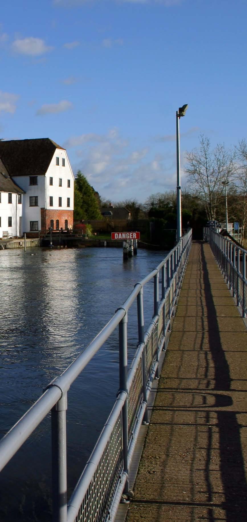
6 Route 3 Directions Relatively easy walking with two uphill sections. Distance: 9.4km (5.8 miles) Time: 2 hours 01 Turn right outside the front of the pub and walk up Remenham Lane in a westerly direction for about just under 200m. 02 Then just before the Kill your Speed sign take the footpath to the left either going over the stile or manoeuvring round the end of the field gate. Walk up the hill following the path keeping to the left of the field and through a narrow strip of woodland to the top. 03 At a T junction of paths turn right onto the other footpath and follow this path across the top of the hill for just over half a mile with fine views looking over the Thames and Hambleden valley eventually arriving at a lane (Remenham Church Lane). 04 If the field gate is closed and locked you will have to use the stile, turn right here and walk along the lane until it joins another lane (Rememham Lane) merging from the right. 05 Continue to follow the lane downhill until you reach a junction, turn right here passing the entrance to the Church of St Nicholas. There has been a church on this site in Rememham since time immemorial. The first Rector is mentioned in a Westminster Abbey Charter in 1076; the church is mentioned in the Domesday Book of 1086; and the first rector, John de Baldake, was recorded in Originally, the church was a chapelry of Hurley and served by the monks of Hurley Priory. The church was substantially restored in 1838 and again in 1870 when the south transept was added. 06 This lane is a cul-de-sac, walk down to the end and then pass the entrance to Rememham Manor to pick up a footpath that connects with the Thames Path. Temple Island was constructed and designed as a fishing lodge for Fawley Court by Architect James Watt in The Island is now owned by Henley Royal Regatta and is the starting point of the 1.25 mile Regatta course. 07 Turn right and continue walking along the Thames Path to Temple Island and then on to Hambleden Lock. 08 Leave the path and walk across the lock gates and use the walkway to cross the weir, passing Hambleden Mill on the far bank. Once you reach the other side of the Thames follow the access road of the Hambleden Marina and then the signed path into a short alley leading to the main Henley to Marlow road (A4155). Hambleden Mill is an historic watermill, it was mentioned in the Domesday Book when it had a rent of 1/year. Before 1235 the mill was granted to Keynsham Abbey. It was converted into apartments in Turn right and then cross the road on to the pavement opposite following the waymarker as the pavement follows the road to Hambleden. 10 Cross over to the right hand of the road where the pavement starts and carry on for a further 300m until you reach a turning on the right signposted to Rotten Row. 11 Cross over the side road and go through a metal kissing gate into a field and continue ahead, along the field with the hedge on the left. 12 Go through a kissing gate, cross a track and pass through another kissing gate. 13 Stay on the footpath, running parallel with the road until the footpath ends with another kissing gate by the side of the chalk stream. 14 Go through the gate and turn right and follow the road into the centre of Hambleden, passing the church on the left. 15 Where the road goes left continue ahead along a cul de sac passing the local inn, the Stag and Huntsmen, and continue to walk straight up a tarmac track for about 100m before turning right on to a signed footpath which is an unmade track. 16 Stay on this track for about 0.5km until you reach the intersection with another track bear right and continue until you reach two kissing gates either side of the track. 17 Go through the left gate into the field and after about 80m exit the field by the same kissing gate you entered it on your outward trip. 18 Retrace your steps along the road until you reach the A4155, cross the road, turn right and follow the signed footpath through the small alley. 19 Return over the weir and the lock and then turning left to rejoin the Thames Path. 20 Follow the path until you reach Aston Ferry Lane then turn right and walk up the lane to arrive back at the Flowerpot again.
7 The Flower Pot Opening Hours: Mon Fri: 11am 3.30pm & 6pm 11pm Sat: 11am-12pm Sun: 12pm-11pm Kitchen Open: Mon-Sat: 12noon-2.30pm & 6pm-9pm Sun: 12noon-2.30pm Disabled Access Dog Friendly Family Friendly Garden/Patio Hold a Party Park the Car WiFi Access The Flower Pot Ferry Lane Aston, Henley-on-Thames Oxfordshire RG9 3DG Tel: Brakspear, The Bull Courtyard, Bell Street Henley-on-Thames, Oxfordshire RG9 2BA info@brakspear.co.uk This info was correct at the time of going to print. Printed April 2017 v1
How to get there. Respect - Protect - Enjoy
 How to get there Driving: Postcode is OX10 6AD with a car park for customers. Nearest station: Goring & Streatley station is 5.6 miles away. We re delighted to present three circular walks all starting
How to get there. Respect - Protect - Enjoy
 How to get there Driving: Postcode is RG9 5PF and there is a car park just across from the pub. Nearest station: Henley-on-Thames station is 5.6 miles away. We re delighted to present three circular walks
How to get there. Respect - Protect - Enjoy
 How to get there Driving: Postcode is RG9 6QU and there is a car park for customers. Nearest station: Marlow train station is 7.8 miles away. We re delighted to present three circular walks all starting
How to get there. Respect - Protect - Enjoy
 How to get there Driving: Postcode is OX49 5HL with a car park for customers Nearest station: Henley on Thames station is 9.5 miles away. We re delighted to present three circular walks all starting and
Aston Village: The Flowerpot (pub walk)
") point your feet on a new path Aston Village: The Flowerpot (pub walk) Distance: 10 km=6¼ miles or 8 km=5 miles (omitting the weir) Region: Berkshire, Chilterns Author: MacMeadow Refreshments: Henley, Aston
point your feet on a new path Aston Village: The Flowerpot (pub walk) Distance: 10 km=6¼ miles or 8 km=5 miles (omitting the weir) Region: Berkshire, Chilterns Author: MacMeadow Refreshments: Henley, Aston
Husthwaite to Byland Abbey
 Husthwaite to Byland Abbey This walk begins with a loop round the village of Husthwaite and continues towards Coxwold along a disused railway line, which is now a right of way. It passes through Coxwold
Danbury Words and pictures by Laurie Page of the Public Rights of Way team at Essex County Council.
 Danbury Words and pictures by Laurie Page of the Public Rights of Way team at Essex County Council. An undulating walk from Danbury village to the bluebells at the National Trust property of Blakes Wood.
Walk 7: Watchet to washford
 Walk 7: Watchet to washford Length: Moderate - 7.5 miles / 12 km Good For: Theme: History Duration: 2-3 hours depending on speed of walking Notes: This is a moderate to difficult walk in places, with steps,
The Mendip Way. Route Directions and Maps Wells to Frome
 The Mendip Way Route Directions and Maps Wells to Frome Website: www.mendiphillsaonb.org.uk Email: mendip@mendiphillsaonb.org.uk Facebook & Twitter: @MendipHillsAONB Phone: 01761462338 1 Wells to Shepton
Approximate distance: 10 miles For this walk we ve included OS grid references should you wish to use them. Start. End
 Approximate distance: 10 miles For this walk we ve included OS grid references should you wish to use them. 2 3 Start End 1 N W E S Reproduced by permission of Ordnance Survey on behalf of HMSO. Crown
LOCAL CIRCUIT EM1: EAST MALLING & BARMING HEATH. N 2m ROADS: Significant roads PATHS: Starting direction Barming Longsole Mission Church
 Ditton Church Scott Close LOCAL CIRCUIT EM1: EAST MALLING & BARMING HEATH 6 Community Centre F Open fields (see 'Introductory Notes') 1m 88 Direction label (as in the walk notes) East Malling Church -
Henley via Hambleden Circular
 Main walk last checked Option b) last checked 26 January 2018 30 July 2016 Document last updated: 8 October 2018 This document and information herein are copyrighted to Saturday Walkers Club. If you are
The Hundred Parishes
 The Hundred Parishes Walks from railway stations number 9 6.4 miles (10kms) from Bishop s Stortford to Stansted Mountfitchet Start: Bishop s Stortford station (Grid Reference TL492209) (ample parking and
Bonnie Prince Charlie Walk
 Bonnie Prince Charlie Walk A waymarked route from Ashbourne to Derby to celebrate the 60th anniversary (1995) of the formation of the Ramblers' Association. This route follows the general direction of
Harlington - Sharpenhoe - Pulloxhill
 Harlington - Sharpenhoe - Pulloxhill ID: 3676, Distance: 8 miles, Height gain: 140 Metres, Map: Explorer 193 Luton & Stevenage, Contributor: Dennis Jeanes Duration: 3 Hours 27 Mins Features Church,Great
Slindon Folly - South Downs, West Sussex
 Slindon Folly - South Downs, West Sussex Starts at Park road-side near entrance to Slindon College 2 hours 15 minutes 4.5miles 7.2km Easy ID: 0.1598 Developed by: Chris Mumford Checked by: Rockpit www.ramblersroutes.org
Walk Description. Directions
 Title: Saffron Trail: Battlesbridge to Chelmsford Distance: 14¾ miles Time taken: 6 hours Start Point: Outside the Barge Inn, Battlesbridge OS Explorer Map: 175 & 183 Grid Ref.: TQ 780 947 Transport: Rail:-
Follow the Lantern Way clockwise from Dursley Town Hall through Cam & Coaley to Uley and back to Dursley (about 14 miles)
") According to the Rev Kilvert's diary of 1873, couples on their way to evening services in winter followed a practical though unusual local tradition: "My Mother says that at Dursley, when ladies and gentlemen
According to the Rev Kilvert's diary of 1873, couples on their way to evening services in winter followed a practical though unusual local tradition: "My Mother says that at Dursley, when ladies and gentlemen
9.5 km Circular 3 hours
 MEDIEVAL WAVERLEY Challenging Terrain A 6 mile (9.5km) undulating circular walk from Tilford village passing close to The Sands village and the historic ruins of Waverley Abbey. From the top of Crooksbury
BALCOMBE AND ARDINGLY RESERVOIR, WEST SUSSEX
 BALCOMBE AND ARDINGLY RESERVOIR, WEST SUSSEX 7 miles Circular 4 hours 080816 Challenging Terrain Hi, I'm Luke and this is my West Sussex Weekends walk It's a 7 mile loop from Balcombe rail station, taking
9.5 km Circular 3 hours
 RANMORE CIRCULAR A 6 mile (9.5km) circular walk from Boxhill and Westhumble Station in the village of Westhumble, passing through part of the Polesden Lacey Estate, Ranmore Common and Denbies Vineyard.
RILLINGTON TO MALTON by Tania Dickinson
 RILLINGTON TO MALTON by Tania Dickinson This walk takes you from the Vale of Pickering up on to the Wold scarp, before dropping down again through the pretty village of Settrington and joining the Centenary
LDWA SOUTH DOWNS MARATHON
 AHD ahead SDW South Downs Way BL/BR bear left/bear right TL/TR turn left/turn right SP signpost/fingerpost X cross LEG 1 - EAST DEAN to WP1 NORTON GR 470019. Open 1030 to 1300. 9.6 miles. 1.1 From village
Redesdale Arms. A Trio of Walks
 Redesdale Arms A Trio of Walks Welcome to The Redesdale Arms Hotel The award winning 34 bedroom Redesdale Arms Hotel sits at the gateway to the Cotswolds in the High Street of the historic town of Moreton-in-Marsh.
SUMMER WALK 10. The Chairmakers, Worlds End
 SUMMER WALK 10 The Chairmakers, Worlds End Tuesday 10 th June 7.30pm This is a very short walk made so due to the majority of the footpaths in the area around the Chairmakers being overrun with high nettles
Lincolnshire Walks. Ancaster. Three cir cular walks of2 3/4,4or 6km (11/3, 21/2 or 33/4 miles)
") Lincolnshire Walks Ancaster Three cir cular walks of2 3/4,4or 6km (11/3, 21/2 or 33/4 miles) Introduction These walks are set in the attractive countryside around the historic town of Ancaster. The town
Lincolnshire Walks Ancaster Three cir cular walks of2 3/4,4or 6km (11/3, 21/2 or 33/4 miles) Introduction These walks are set in the attractive countryside around the historic town of Ancaster. The town
The North Pennines from near Langwathby
 3.6 Langwathby to Armathwaite Map panel?? Distance 12.7 miles (20.5 km) Terrain farm, woodland and riverside paths; some potentially muddy tracks; a few short sections of road Grade gently undulating Food
NETTLESTEAD & YALDING
 NETTLESTEAD & YALDING ULL CIRCUIT - Sheet 1 (first and last sections) Open fields (see 'Introductory Notes') 88 Direction label (as in the walk notes) ROADS: 81 10m Significant roads Redhill arm North
Bakewell Club Site - Robin Hood's Stride
 Bakewell Club Site - Robin Hood's Stride Camping and Caravanning Route Summary A circular walk with fabulous views winding it's way through the beautiful White Peak scenery. Points of interest include
LDWA SOUTH DOWNS MARATHON 13 th MAY 2018
 AHD ahead SDW South Downs Way BL/BR bear left/bear right TL/TR turn left/turn right X cross LEG 1 - EAST DEAN to WP1 NORTON GR 470019. Open 1030 to 1300. 9.7 miles. 1.1 From village hall TL and walk to
Thornton le Dale Walks
 Thornton le Dale Walks A collection of circular walks in, and around, the village www.visitthorntonledale.co.uk Thornton-le-Dale Traders Forum and Thornton le Dale Parish Council 1 Thornton le Dale Circular
Tideswell to Castleton
 Tideswell to Castleton 1 Walk summary Length: 14 km, 8.5 miles Maps: OS Explorer OL1 The Peak District - Dark Peak Area, OS Explorer OL24 The Peak District - White Peak Area, OS Landranger 110 Sheffield
NEWLANDS CORNER AND ST MARTHAS
 NEWLANDS CORNER AND ST MARTHAS 10k CIRCULAR ROUTE 2½-3HRS GU4 8SE From Newlands Corner on the North Downs just outside Guildford, you can enjoy one of the most beautiful panoramas of quintessential English
8 Miles Circular 4 hours
 VISIT RYEDALE HELMSLEY AND RICCAL DALE 8 Miles Circular 4 hours 090616 Challenging Terrain An 8 mile (13km) circular walk from the market town of Helmsley in Ryedale. The route heads out across sheep pastures
A circular walk of or km (2 1 4 or miles)
") Grantham A circular walk of 3 3 4 or 5 3 4 km (2 1 4 or 3 1 2 miles) Introduction This relatively short circular walk, which starts in the middle of Grantham, offers plenty of variety. The route takes
Grantham A circular walk of 3 3 4 or 5 3 4 km (2 1 4 or 3 1 2 miles) Introduction This relatively short circular walk, which starts in the middle of Grantham, offers plenty of variety. The route takes
Stokenchurch. Bluebell Woods, Bomber Memorial, Red Kites, Getty s Cricket Ground, Nature Reserve
 Stokenchurch Bluebell Woods, Bomber Memorial, Red Kites, Getty s Cricket Ground, Nature Reserve Bomber Memorial The best time to visit Cowleaze Wood is in the spring when there is a memorable display of
A Walk around Holmes Chapel starting & finishing at Holmes Chapel Railway Station. by Tony & Lindsay Wright (2016)
") A Walk around Holmes Chapel starting & finishing at Holmes Chapel Railway Station. by Tony & Lindsay Wright (2016) Introduction Holmes Chapel Railway Station is on the Crewe to Manchester line. The station
A Walk around Holmes Chapel starting & finishing at Holmes Chapel Railway Station. by Tony & Lindsay Wright (2016) Introduction Holmes Chapel Railway Station is on the Crewe to Manchester line. The station
Clyde Walkway Community Links: Rosebank Circular via Ashgill and Dalserf
 Clyde Walkway Community Links: Rosebank Circular via Ashgill and Dalserf Rosebank Circular via Ashgill and Dalserf Digital Trail Difficulty (out of 3) 1 Distance 7 km / 4.35 miles. Time 2 hours Terrain
Hambleden, the Weir, Medmenham Pheasants and Thames Pasture
 point your feet on a new path Hambleden, the Weir, Medmenham Pheasants and Thames Pasture Distance: 19 km=12 miles or 16 km=10 miles Region: Chilterns Author: Phegophilos easy walking Date written: 29-aug-2010
For Your Own Safety. Please make a note below of the contact number that should be used in the event that you get lost or require other assistance
 Respect Protect Enjoy Respect other people Consider the local community and other people enjoying the outdoors Leave gates and property as you find them and follow paths unless wider access is available
Walk 2: Beamsley Beacon and Bolton Abbey
 Walk 2: Beamsley Beacon and Bolton Abbey Start and Finish: The Memorial Hall, Main Street, Addingham, LS29 0LZ, SE 079 497 The shortest walk is about 5½ miles (8.8km) The medium Walk is about 8¼ miles
THAMES MARATHON INFORMATION PACK
 THAMES MARATHON INFORMATION PACK THE THAMES MARATHON is a 14 km river Thames swimming event, from Henley to Marlow. It is not a race, but a distance challenge event, aimed at open water swimmers who would
Views! village, woodland, hills, high trails, fine houses, hidden church
 point your feet on a new path Heath Distance: 9½ km=6 miles Region: Chilterns Author: Phegophilos Refreshments: easy walking Date written: 13-oct-2017 Map: Explorer 171 (Chiltern Hills West) but this guide
Dyrham and Hinton Parish Walks
 Dyrham and Hinton Parish Walks A series of five walks in the parish, exploring most of the public footpaths. By John Miller Each walk is described in detail, with a complete map, to provide a handy guide
INFORMATION PACK. Saturday 22nd July 2017
 INFORMATION PACK The Club to Pub swim is a 1.5km summer evening swim taking place in the heart of Henley. Starting from Henley Rowing Club, and finishing at the historic Angel on the Bridge (dating back
Walks Around Bishopstone & Hinton Parva
 The Walks: From ½ mile ambles to 8 mile scenic loops Hinton Parva Walks H1 H2 H3 Bishopstone Walks B1 B2 B3 B4 B5 Walk B1: Bishopstone Village, The Dingle (stream) & Pond A short circular village amble
Beautiful Walks from the Blue Ball Inn
 Walk No. 7 COAST AND VALLEY WALK Countisbury, Glenthorne, County Gate, Brendon, Rockford and Wilsham 10 MILES APPROX. Walking time 5 hours approx. (not including breaks)> OS Sheet 64/74 Lynton and Lynmouth.
Route: Skewsby Foulrice Stearsby
 Route: Skewsby Foulrice Stearsby Distance: 7 miles Map: Explorer: 300 Howardian Hills & Malton Start (OS ref): SE625710 Park in the village of Skewsby. Walk east out of the village to the T-Junction and
Green Man Ultra Route Directions 2018
 Green Man Ultra Route Directions 2018 Start-CP1 (9 miles) Community Forest Path (CFP) Frome Valley Way (FVW) From the starting line cross the playing fields diagonally to the metal gates in the hedge lined
There are toilets at Manningtree Station, Flatford (close to the hump back bridge) and in Dedham.
 and in Dedham.") Arriving by Train Main Features of the Walk Outline Route Employs particularly attractive paths, many of which offer impressive views across Dedham Vale. Includes a section along the tidal section of the
Arriving by Train Main Features of the Walk Outline Route Employs particularly attractive paths, many of which offer impressive views across Dedham Vale. Includes a section along the tidal section of the
THE WELLDIGGERS ARMS, HESWORTH AND FITTLEWORTH TRAIL
 THE WELLDIGGERS ARMS, HESWORTH AND FITTLEWORTH TRAIL 5.5 miles Circular 3 hours 041017 Challenging Terrain A 300-year-old pub turned country-inn on the edge of the South Downs National Park, The Welldiggers
Dorridge & District Residents Association A Walk Along The Green Belt From Dorridge to Catherine-de-Barnes
 Dorridge & District Residents Association A Walk Along The Green Belt From Dorridge to Carine-de-Barnes The starting section of this walk through open fields would be destroyed by building of motorway
Although the majority of these walks are around country lanes you should still follow the Country Code:-
 With the update of the Parish Plan was a request for details of any Walks around Pillaton The following pages give several walks that I and my wife have done for many years. Please be aware that NONE OF
Bix and the Assendons
 point your feet on a new path Bix and the Assendons Distance: 8½ km=5½ miles Region: Chilterns Author: Phegophilos Refreshments: Lower and Middle Assendon Map: Explorer 171 (Chiltern Hills West) hopefully
Hammer Vale and Linchmere Common
 point your feet on a new path Hammer Vale and Linchmere Common Distance: 9 km=5½ miles or 6 km=3¾ miles easy walking with one steep section Region: Hampshire, West Sussex Author: Botafuego Refreshments:
Welsh Newton and Woodland
 Welsh Newton and Woodland This is a 8.2km miles (approx) walk which will take about 2.5 hours at a relaxed and leisurely pace. There are a few hills but no steep inclines. Start at Llangrove bus stop and
THE DOG AND DUCK HAREWOODS ESTATE TRAIL. 6 Miles Circular 3 hours. Getting there. Walk Sections
 THE DOG AND DUCK HAREWOODS ESTATE TRAIL Moderate Terrain A 6 mile circular pub walk from the Dog and Duck in Outwood, Surrey. The Dog and Duck is a delightful pub where everyone is made welcome. From walkers
10 km Circular 3 hours
 FRIMLEY AND FRIMLEY GREEN 10 km Circular 3 hours Easy Terrain 250716 A 10km (6 mile) circular walk exploring the canal towpath, riverside path, woodland, heath and small settlements around Frimley in Surrey.
Approximate distance: 5.5 miles For this walk we ve included OS grid references should you wish to use them. Start. End
 Approximate distance: 5.5 miles For this walk we ve included OS grid references should you wish to use them. End 4 1 Start 3 2 N W E S Reproduced by permission of Ordnance Survey on behalf of HMSO. Crown
Discover Shropshire. Walks and Strolls around Bridgnorth
 Discover Shropshire Walks and Strolls around Bridgnorth An Introduction to Bridgnorth Bridgnorth is made up of two towns; the High Town and the Low Town. The Low Town was once a thriving port along the
For more information and to buy this book click here ISBN: CICERONE. Guides for walkers, trekkers, mountaineers, climbers and cyclists
 For more information and to buy this book click here ISBN: 9781852845377 CICERONE Guides for walkers, trekkers, mountaineers, climbers and cyclists www.cicerone.co.uk WALK 5 Ouston and Urpeth Distance
Hexham Abbey to the Racecourse Road
 Hexham Abbey to the Racecourse Road The Yarridge Road, or Racecourse Road as it is often known, runs along the ridge line to the south of Hexham and provides wonderful views of the river valley and fells
Lincolnshire Walks. Grainthorpe. Three circular walks of 2 ¾, 9 and 9 ½ km (1 ¾, 5 ½ and 6 miles)
") Lincolnshire Walks Grainthorpe Three circular walks of ¾, 9 and 9 ½ km (1 ¾, ½ and 6 miles) Introduction Explore the coastal marshes, arable hinterland, Louth Navigation canal and the village of Grainthorpe
Lincolnshire Walks Grainthorpe Three circular walks of ¾, 9 and 9 ½ km (1 ¾, ½ and 6 miles) Introduction Explore the coastal marshes, arable hinterland, Louth Navigation canal and the village of Grainthorpe
This walk description is from happyhiker.co.uk
 This walk description is from happyhiker.co.uk Pendle Hill Walk From Barley Starting point and OS Grid reference Ordnance Survey map Distance Traffic light rating Barley village honesty box car park OS
Weatherman Walking. Approximate distance: 5.5 miles For this walk we ve included OS grid references should you wish to use them. Start.
 Approximate distance: 5.5 miles For this walk we ve included OS grid references should you wish to use them. 4 1 Start End 3 2 N W E S Reproduced by permission of Ordnance Survey on behalf of HMSO. Crown
Distance: 14 km=8½ miles or 7 km=4½ miles easy-to-moderate walking
 point your feet on a new path Normandy Distance: 14 km=8½ miles or 7 km=4½ miles easy-to-moderate walking Region: Surrey Author: Botafuego Refreshments: Pirbright, Ash date written: 20-feb-2012 date revised:
Outwood: oaks, buttercups and windmill
 point your feet on a new path Outwood: oaks, buttercups and windmill Distance: 9 km=5½ miles Region: Surrey Author: Schwebefuss Refreshments: Outwood easy walking Date written: 23-may-2014 Last update:
Brightwalton, Chaddleworth, Leckhampstead, Peasemore: Four Downland Villages
 point your feet on a new path Brightwalton, Chaddleworth, Leckhampstead, Peasemore: Four Downland Villages Distance: 13 km=8 miles Region: Berkshire Author: MacMeadow Refreshments: Peasemore, Leckhampstead
6.5 km Circular 2 hours
 REIGATE MILLS AND PILLBOXES A 4 mile (6.5km) enjoyable circular walk from Reigate Heath, passing Reigate Heath windmill, Wonham Mill and pillboxes built during the Second World War. 6.5 km Circular 2 hours
Masson Hill. Walk. Approximately 4 km. Moderate Walk Begins from Matlock Railway Station
 Masson Hill Walk Approximately 4 km Moderate Walk Begins from Matlock Railway Station TOWN WALKS Masson Hill walk is approx. 4 km. It can be walked in a couple of hours or so. Enjoy your walk and the beautiful
Thornton le Dale Walks
 Thornton le Dale Walks A collection of walks in and around the village Thornton le Dale Traders Forum www.visitthorntonledale.co.uk Thornton le Dale Walks Walk 1: Beck Isle Cottage and All Saints Church
Chipstead to Kingswood walk
 Saturday Walkers Club www.walkingclub.org.uk Chipstead to Kingswood walk Ancient woodland, open downs and farmland in London's Green Belt Length OS Map Toughness Features Main Walk: 15½ km (9.6 miles).
Key Information. Self-Guided Walk Exploring Sedbergh
 Self-Guided Walk Exploring Sedbergh A great short walk - ideal for an early evening in summer. This is a lovely circuit of Sedbergh visiting some of the historic buildings as well as ambling by the river
5 Miles Circular 2.5 hours
 VISIT RYEDALE KIRKBYMOORSIDE AND ST GREGORY S MINSTER Challenging Terrain A 5 mile (8 km) circular walk from the market town of Kirkbymoorside in Ryedale. The route heads west through open fields and pastures,
No. 1 By River Ribble & Brungerley Park 3¼ Miles,
 RVRNEWS 102 No. 1 By River Ribble & Brungerley Park 3¼ Miles, Approx 2 Hours This walk starts at the gate on platform 2 of Clitheroe station. Leaving the station turn left making towards Kirkmoor Rd and
Walks in Lenham. Three delightful walks in and around Lenham from 30 minutes to 90 minutes with map and photographic guides. l l l ABOUT LENHAM
 Walks in Lenham Three delightful walks in and around Lenham from 0 minutes to 90 minutes with map and photographic guides l l l ABOUT LENHAM The medieval village of Lenham, in the Borough of Maidstone,
Hascombe and Winkworth Arboretum Downs Link Path, Smithbrook Kilns
 point your feet on a new path Hascombe and Winkworth Arboretum Downs Link Path, Smithbrook Kilns Distance: 18 km=11 miles Region: Surrey Author: RDC easy walking Date written: 7-may-2016 Last update: 30-aug-2018
Walk 2: doniford to east quantoxhead
 Walk 2: doniford to east quantoxhead Length: 9 ¼ miles / 15km Good For: Difficulty: Moderate Theme: Nature Notes: This walk is tidal - please check tide times before setting off. Dogs are welcome but need
GENERAL INFORMATION PLEASE FOLLOW THE COUNTRYSIDE CODE:
 KNIGHTON CIRCULAR WALKS The East Radnor Group of the Ramblers Association invites you to enjoy these walks around Knighton. Knighton is an excellent centre for walks in the lovely unspoilt mid-wales countryside
The main feature of this tranquil walk is a visit to the source of the Thames (the Thames head) which is in a field just 3 km from Kemble station
 which is in a field just 3 km from Kemble station") SWC Walk DRAFT Kemble circular: the source of the River Thames. The main feature of this tranquil walk is a visit to the source of the Thames (the Thames head) which is in a field just 3 km from Kemble
SWC Walk DRAFT Kemble circular: the source of the River Thames. The main feature of this tranquil walk is a visit to the source of the Thames (the Thames head) which is in a field just 3 km from Kemble
Walk Description. Directions
 Title: East Hanningfield Distance: 8 miles / 9 miles Time taken: 3-3½ hours Location: 5 miles south east of Chelmsford Parking: Free car park off The Tye, East Hanningfield, next to the primary school
Fingest, Christmas Common, Pishill, Turville Red Kites and Red Deer
 point your feet on a new path Fingest, Christmas Common, Pishill, Turville Red Kites and Red Deer Distance: 23 km=14 miles Region: Chilterns Author: Bryntafion Refreshments: every village! Map: Explorer
10 Miles Circular 5 hours
 VISIT RYEDALE PICKERING AND CAWTHORN CAMPS 10 Miles Circular 5 hours Moderate Terrain 120616 A 10 mile (16km) there and back walk from the market town of Pickering in Ryedale. The route heads north through
HARDMOORS 26.2 WHITE HORSE HALF ROUTE DESCRIPTION - 018
 HARDMOORS 26.2 WHITE HORSE HALF ROUTE DESCRIPTION - 018 Follow Cleveland Way, keeping to the left hand path (right path is a bike trail) Ignoring any turnings to the left or right At path junction (after
ST. AGNES. you cannot put a time limit on beauty.
 ST. AGNES CIRCULAR WALKS AROUND There are many enjoyable and picturesque walks around St. Agnes most are signposted and are featured on the St. Agnes Mini-guide map. Because most of our footpaths are in
Lincolnshire Limewoods Walks. Woodhall Spa. A circular walk of 13km (8 miles)
") Lincolnshire Limewoods Walks Woodhall Spa A circular walk of 13km (8 miles) Introduction The Lincolnshire Limewoods is an area between Wragby, Bardney and Woodhall Spa. It is a fantastic place to explore
Lincolnshire Limewoods Walks Woodhall Spa A circular walk of 13km (8 miles) Introduction The Lincolnshire Limewoods is an area between Wragby, Bardney and Woodhall Spa. It is a fantastic place to explore
Cilgerran Wildlife Park Circular Walk
 Walking embrokeshire Cilgerran Wildlife ark Circular Walk It s good to walk, so why not step out and sample some of the walks your neighbourhood has to offer. This pleasant and interesting walk which starts
Walking Pembrokeshire.
 Walking Pembrokeshire Canaston Woods Walk It s good to walk, so why not step out and sample some of the walks your neighbourhood has to offer. This pleasant and interesting walk which starts and finishes
Walk: NOC 08 Location: Cym Glyn near Brecon
 33 Walk: NOC 08 Location: Cym Glyn near Brecon Directions: Not easy to find at all. Go to Libanus, then head towards Brecon on the A470. Take minor C road single track lane first right as you come out
Pull the gate towards you and ride through. The third gate takes you onto Hound House Road. Watch out for traffic. 4
 PEASLAKE TO FARLEY HEATH AND WINTERFOLD 12k CIRCULAR ROUTE 2HRS GU5 9QW This interesting trail takes you across a variety of terrain, from the sandstone of Pitch Hill, across open farmland with fabulous
Fertile farms in the heart of Kent
 55 55 Fertile farms in the heart of Kent A bright sunny day is perfect for enjoying the rich and fertile Kent countryside and outstanding views across the valley of the Great Stour to the North Downs.
TOCKENHAM. Walks for Healthy Living. The Countryside Code (October 2016) Respect other people:
 Respect other people:") The Countryside Code (October 2016) TOCKENHAM Respect other people: consider the local community and other people enjoying the outdoors leave gates and property as you find them and follow paths unless
The Countryside Code (October 2016) TOCKENHAM Respect other people: consider the local community and other people enjoying the outdoors leave gates and property as you find them and follow paths unless
Distance: 9½ km=5¾ miles moderate walking or two walks of 4¼ km=2¾ miles and 6½ km=4 miles
 point your feet on a new path White Hill, Headley Distance: 9½ km=5¾ miles moderate walking or two walks of 4¼ km=2¾ miles and 6½ km=4 miles Region: Surrey Author: Fusszweig Refreshments: Headley Date
Footpaths and walks in the Leckhampton Fields
 APPENDIX 5 Footpaths and walks in the Leckhampton Fields Because of its network of footpaths, the Leckhampton Fields have many different walks. The rich diversity of landscape, hedgerows, trees, streams,
Bledlow Beechwoods and Bledda s Rest
 point your feet on a new path Beechwoods and Bledda s Rest Distance: 16 km=10 miles Region: Chilterns Author: Phegophilos Refreshments:, Bennett End moderate walking Date written: 2-sep-2010 Last update:
Angel Drove carpark 3/day
 GETTING TO ELY ( A on the map below marks the city centre; for a larger scale see the map at the end of the directions, where there are also details of car parking and pedestrian access to the venue) Angel
Oldbury & Littleton, South Gloucestershire
 Oldbury & Littleton, South Gloucestershire Starts at Church Lane, Oldbury. BS35 1QF 2 hours 0 minutes 5.2miles 8.4km Easy ID: 0.2468 Developed by: GEOFF MULLETT Checked by: Marion Stone www.ramblersroutes.org
Uif!Cmbdl!Kvh!bne! Wbsnibn!Qbsl-!Ipstibn-! Wftu!Tvttfy
 Uif!Cmbdl!Kvh!bne! Wbsnibn!Qbsl-!Ipstibn-! Wftu!Tvttfy 7/6!njmft! Djsdvmbs!!!! 3/6!up!4! ipvst 200114 Moderate Terrain Uif!Cmbdl!Kvh!jt!b!hsfbu!upxn!qvc!dfnusfe! bspvne!b!mbshf!cbs!xjui!xppefn!qbnfmmjnh-!
Thirsk Castle. To begin the walk go to the west of
 Past and Present is a walk around Thirsk and Sowerby to enjoy the town and countryside, but also to learn about local history. It takes in sites of historical and environmental approximately three miles
YHA RAVENSTOR Ideas for walks in the local area
 YHA RAVENSTOR Ideas for walks in the local area How to use this book This book contains some suggestions for enjoyable walks in the countryside immediately surrounding YHA Ravenstor. We hope that our guests