Teralba to Charlestown Park track head
|
|
|
- Chester Tyler
- 5 years ago
- Views:
Transcription


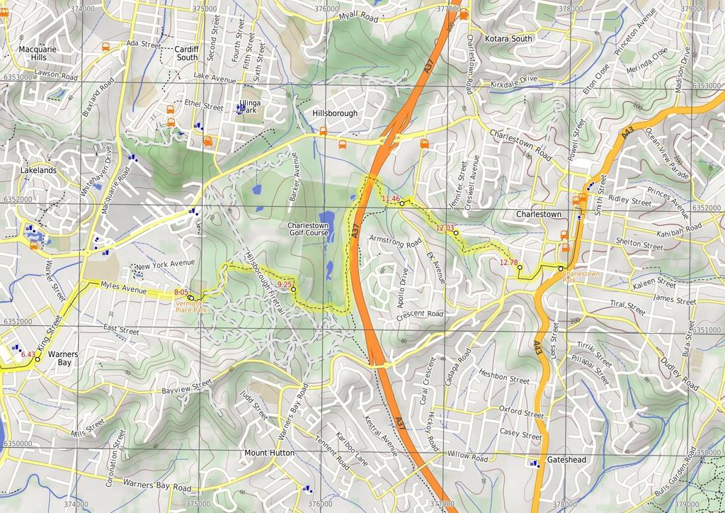
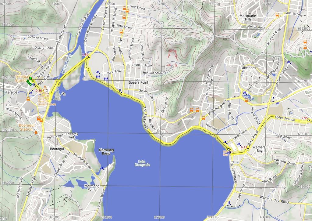
1 Teralba to Charlestown Park track head 4 hrs 30 mins 13.3 km One way Moderate track 3 220m This section of the Great North Walk starts from the Teralba train station and winds down and around the edge of Lake Macquarie. The walk passes through the Cockle reserve, and continues to Warners bay and up along the roads, before cutting through the bush to Charlestown, where it winds around the golf course and finishes at the Charlestown Park track head. 103m 0m Lake Macquarie LGA Maps, text & images are copyright wildwalks.com Thanks to OSM, NASA and others for data used to generate some map layers.
2 Teralba Lakeside Caravan Park on Anzac Parade Teralba Lakeside Caravan Park at 21 Anzac Parade, Teralba has unpowered tent sites ($20/night), standard cabins ($90 for 5 people) and deluxe cabins ($125 for 7 people). The manager is available from 8am till 8.30pm. For more information, phone (02) You can grab a meal or beverage from the 'Great Northern Hotel' or grab a snack from the local servo, just up the road. Warners Bay Warners Bay is a large, open bay on Lake Macquarie, with a public park and small shopping centre nearby. There are cafes and restaurants with alfresco dining, the 'Centro' shopping centre, specialty shops, boutiques and a post office. The public park on the lakeshore has a shared bike/walking path, picnic tables, barbeques, toilets and water. A-must-stop ice cream shop on the Esplanade is Dippin Dots, they have a unique ice cream that has been made using super-cold freezing methods to make little beads of ice cream. Vermont Place Park Vermont Place Park, at the end of Vermont Place in Warners Bay, is an open grassed park surrounded by native forest. The park has a children's playground, picnic table, a shelter and water fountain (water may not be available). Charlestown Park 'Charlestown Park', by the Pacific Highway in Charlestown, offers a picnic table, shelter, barbeque and war memorial. Charlestown Park is also known and signposted as 'Anniversary Grove'. Before You walk Bushwalking is fun and a wonderful way to enjoy our natural places. Sometimes things go bad, with a bit of planning you can increase your chance of having an ejoyable and safer walk. Before setting off on your walk check 1) Weather Forecast (BOM Hunter District) 2) Fire Dangers (Greater Hunter) 3) Park Alerts () 4) Research the walk to check your party has the skills, fitness and equipment required 5) Agree to stay as a group and not leave anyone to walk solo Think before you TREK The 'Think before you TREK' program developed by NSW Police & NPWS promotes the benefits of planning ahead for your bushwalking trip by using an easy to remember acronym: adequate supplies of food, water, navigation and first T Take aid equipment. your planned route and tell friends and family when R Register you expect to return. beacon (PLB's) should be carried on walks with E Emergency significant gaps in mobile coverage (check terrain profile). to your planned route and follow the map and walking K Keep trails. Topo Maps The maps provided on wildwalks are helpful, but there are times where you may need maps covering a broader area. Maps that cover this walk include; 1: Map Series:92323S WALLSEND 1: Map Series:9232 NEWCASTLE Grade This walk has been graded using the AS The overall grade of the walk is dertermined by the highest classification along the whole track. 3 Grade 3/6 Moderate track Length 13.3 km One way Time 4 hrs 30 mins Quality of track Formed track, with some branches and other obstacles (3/6) Signs Directional signs along the way (3/6) Experience Required Some bushwalking experience recommended (3/6) Weather Weather generally has little impact on safety (1/6) Infrastructure Limited facilities, not all cliffs are fenced (3/6)
3 Are you ready to have fun? Please ensure you and your group are well prepared and equipped for all possible hazards and delays. Check park closures, weather information and Fire Danger Rating before setting out. Optional side trips and alternate routes noted are not included in this walks overall grade, length or time estimate. Please allow extra time for resting and exploring areas of interest. The authors, staff and owners of wildwalks take care in preparing this information but will not accept responsibility for any inconvenience, loss or injury you may experience. Please take care, have fun - Happy Walking. Getting there You can get to Teralba Train Station (gps: , ) by car, train or bus. Car: There is free parking available. You can get back from Charelstown Park (gps: , ) by car or bus. Car: There is free parking available. Find up to date and more information inlcuding; travel directions, weather, park closures and walker feedback at 0 Teralba Train Station (360 m 6 mins) From Teralba station (at the top of the overpass steps), this walk follows the railway bridge steps south, initially keeping the station building on your right. This walk follows the steps down and heads along the footpath for about 30m, to find a 'Great North Walk' sign. This walk then follows the 'Newcastle' arrow across William St, coming to a GNW arrow post on the intersection of William St and Anzac Parade, opposite the 'The Great Northern Hotel'. Continue straight: From the intersection, this walk follows the footpath alongside Anzac Parade gently downhill, past 'Teralba Fire Station' (on your left). The walk follows the footpath for about 80m to pass 'Anzac Park' (and toilets opposite the road on your right), then continues straight ahead for about 200m crossing York and Margaret St, to come beside 'Teralba Lakeside Caravan Park' (on your left) Teralba Lakeside Caravan Park on Anzac Parade Teralba Lakeside Caravan Park at 21 Anzac Parade, Teralba has unpowered tent sites ($20/night), standard cabins ($90 for 5 people) and deluxe cabins ($125 for 7 people). The manager is available from 8am till 8.30pm. For more information, phone (02) You can grab a meal or beverage from the 'Great Northern Hotel' or grab a snack from the local servo, just up the road Teralba Lakeside Caravan Park on Anzac Parade (1.5 km 24 mins) Continue straight: From the 'Teralba Lakeside Caravan Park', this walk follows Anzac Parade gently downhill, initially keeping the caravan park on your left. After 160m this walk then turns left (following the GNW arrow post) into 'Lake Crescent' (just before the larger Five Islands Road). This walk follows 'Lake Crescent' for 130m, until coming to the end of the road and a shared footpath/cycleway. Continue straight: From the end of Lake Crescent, this walk follows the footpath, keeping the large Five Islands Rd up to your right. The walk follows the footpath for about 250m, until coming to a T-intersection with another footpath (beside the 'Raymond Smith' concrete monument). Turn right: From the intersection, this walk follows the GNW arrow post along the footpath and through the underpass. Just after the underpass, this walk heads gently up the ramp to come beside Five Islands Rd. Here, the walk turns right to follow a footpath for about 900m, crossing over a two bridges and an island (two arms of Cockle Creek). On the far side the second bridge (Watkins Bridge), this walk comes to the intersection with another footpath, marked by a GNW arrow post Int of Five Islands Rd & Speers Point footpaths (4 km 1 hr 6 mins) Turn right: From the intersection, this walk follows the GNW arrow post gently downhill along the footpath towards the water, while keeping the playing fields on the left. The walk continues on the footpath (beside the bridge), to then bend left and lead along side a small road and Cockle Creek (on your right), until coming to a road crossing with Creek Reserve Rd, on the far side of 'Macquarie Field'. Continue straight: From the intersection, this walk follow the GNW arrow post across Creek Reserve Rd and follows the footpath through Speers Point Park passing the 'Walk Safe' sign (on your right). The walk continues through Speers Point Park for about 500m, past picnic shelters, a stage, a wharf to then cross the road beside 'Speers Point Swimming Pool'. The walk continues on the footpath, with the water on the right for about 300m to pass the War Memorial. Here the walk continues along the waters edge for 2.5km to pass a car park then cross 'North Creek' on the road bridge. Continue for another 100m, through the park, then just past the toilet block the footpath leads to a large 'Great North Walk - Warners Bay Trackhead' sign, beside the traffic lights Warners Bay Warners Bay is a large, open bay on Lake Macquarie, with a public park and small shopping centre nearby. There are cafes and restaurants with alfresco dining, the 'Centro' shopping centre, specialty shops, boutiques and a post office. The public park on the lakeshore has a shared bike/walking path, picnic tables, barbeques, toilets and water. A-must-stop ice cream shop on the Esplanade is Dippin Dots, they have a unique ice cream that has been made using super-cold freezing methods to make little beads of ice cream Int of Warners Bay footpath AND The Esplanade foot (500 m 10 mins) Turn left : From the intersection, near the toilet block this walk follows the 'Charlestown Park' sign across The Esplanade using the pedestrian crossing. On the other side this walk turns right and follows the footpath for about 160m (past 'Dippin Dots' ice cream shop) until coming to the intersection of The Esplanade and King Street(at the large roundabout). Turn left: From the intersection, this walk follows the footpath gently uphill alongside 'King St', heading directly away from the water. The walk follows King St (passing traffic lights and a roundabout) and heads towards Cardiff for about 300m, to find a set of traffic lights, at the Caltex Servo. Here the walk crosses King St (using the pedestrian lights) and follows the footpath through the nature strip to find Queen St and a GNW arrow post (Queen St is a minor street running parallel to King St) Queen St (near King Street Crossing) (1.5 km 25 mins) Turn left: From the intersection, (near the King Street crossing), this walk follows the footpath beside Queen Street, past the fruit store, keeping King St to your left. The walk continues along Queen St for about 500m, crossing 'Pring St' to the grassy area at the end of road. From here the walk follows GNW arrow post along the footpath, along the grassy verge to come to the northern section of 'Queen St'. The walk follows 'Queen St' for another 170m, to turn right and follow 'Myles Ave' for about 80m, until coming to a three-way intersection with Yorston St (on the right). Continue straight: From the intersection, this walk follows the grassy verge beside Myles Rd gently uphill, initially keeping Yorston St on your right. This walk continues to follow Myles Rd and GNW arrow posts for about 700m, first crossing 'Bonarius St', then crossing a few few more side streets until coming to an intersection, with 'Vermont Place' (on the right) Int of Myles Avenue AND Vermont Place (110 m 2 mins) Turn right: From the intersection, this walk the footpath down a small dip then gently uphill alongside 'Vermont Place' for about 100m, until coming to the end of the street on the edge of of a grassy park Vermont Place Park Vermont Place Park, at the end of Vermont Place in Warners Bay, is an open grassed park surrounded by native forest. The park has a children's playground, picnic table, a shelter and water fountain (water may not be available) End of Vermont place (1.2 km 23 mins) Continue straight: From the end of Vermont Place, this walk follows the GNW arrow post, along the footpath through the gate and into the park. The footpath leads around the edge of the park, past a playground then continues around the back of the oval for another 80m, to an intersection with a management trail, marked with a gate and a 'Great North Walk' sign. Turn right: From the edge of the park, this walk follows the 'The Great North Walk' sign through the locked gate heading moderately steeply uphill along the management trail, through forest. The walk follows GNW arrow markers (ignoring side tracks) for about 350m, to an intersection, with a track on the right. Turn right: From the intersection, this walk follows the GNW arrow post east gently uphill along the eroded track. The walk continues for about 220m, to find an open area with overhead power lines. This walk then crosses underneath the power lines (following the GNW arrow markers) and leads gently downhill for about 500m, until coming to an intersection, with a track on the left (about 10m after a deeply eroded section of track) Int of GNW & Charlestown Golf Course Tracks (2.2 km 38 mins) Continue straight: From the intersection, this walk follows the GNW arrow post south, gently downhill along the narrow track. This walk continues to follow the track for about 250m, passing views of the golf course (on the left), to cross a timber footbridge. Here the walk continues alongside the golf course for about 1.3km, to then lead down through the West Charlestown Bypass underpass. On the other side of this road the walk continues gently uphill for about 500m, to an intersection, with E K Ave Int of Charlestown golf course track AND E K Avenu (570 m 9 mins) Turn left: From the intersection, this walk follows the GNW arrow post gently downhill along the concrete footpath, beside E K Avenue. After about 70m this walk comes to GNW arrow post at the signposted bus stop). Turn right: From the bus stop, this walk follows the GNW arrow post, across E K Ave to then follow the indistinct track alongside a new development (on your left). The walk follows the forested creek (on your right) and the edge of the development for about 160m, to veer right at an intersection marked with a GNW arrow post. The walk follows this track gently downhill for about 120m, to cross a timber footbridge, then continues alongside the creek for almost 200m, to find the end of Park St. Continue straight: From the end of Park St, this walk follows the footpath gently uphill for about 70m, past three houses to come to an intersection with a track (between the houses), on your right, marked with a GNW arrow post Int of Park Street & GNW Arrow Marker (750 m 17 mins) Turn right: From no. 72 Park St, this walk follows the GNW arrow post between the house following the grassy track gently downhill. The track leads down timber steps through dense forest for about 130m, to cross an flat concrete footbridge. The track then leads up the moderately steep hill (with the creek on your left) for about 150m, then leads more gently uphill for a further 250m, to cross the creek at an flat timber footbridge. The walk continues (with the creek now on the right) for about 170m, to come to grass clearing behind some houses. Here the walk turn right, following the GNW arrow post gently uphill for about 80m, until coming to a T-intersection, with Anjon St.

4 12.78 Int of Anjon St & GNW Arrow Post (550 m 10 mins) Turn right: From the dip in Anjon St, this walk follows the GNW arrow post south along the grassy verge beside the street, initially keeping the bush reserve to your right. At the top of the hill, this walk crosses 'Patricia Ave' and turns left to follow the footpath for about 250m, to turn then right at a roundabout into 'Lincoln St'. This walk continues uphill along side 'Lincoln St' for about 170m, over a rise and crosses 'Carl Cl' to head gently downhill for about 50m, until coming to an intersection, with traffic lights at 'Pacific Highway', beside 'Charlestown Park' Charlestown Park 'Charlestown Park', by the Pacific Highway in Charlestown, offers a picnic table, shelter, barbeque and war memorial. Charlestown Park is also known and signposted as 'Anniversary Grove'.
5
6
7 Summary navigation sheet for the Teralba to Charlestown Park track head km From 0.00 Teralba Train Station , (GR Wallsend, ) Teralba Lakeside Caravan Park on Anzac Parade , (GR Wallsend, ) Int of Five Islands Rd & Speers Point footpaths , (GR Wallsend, ) Int of Warners Bay footpath AND The Esplanade footpath , (GR Wallsend, ) m 6 mins 1.5 km 24 mins 4 km 1 hr 6 mins 500 m 10 mins 6.43 Queen St (near King Street Crossing) , (GR Wallsend, ) 7.95 Int of Myles Avenue AND Vermont Place , (GR Wallsend, ) 8.05 End of Vermont place , (GR Wallsend, ) 9.25 Int of GNW & Charlestown Golf Course Tracks , (GR Wallsend, ) Int of Charlestown golf course track AND E K Avenue , (GR Wallsend, ) km 25 mins 110 m 2 mins 1.2 km 23 mins 2.2 km 38 mins 570 m 9 mins Turn left: From the intersection, (near the King Street crossing), this walk follows the footpath beside Queen Street, past the fruit store, keeping King St to your left. Turn right: From the intersection, this walk the footpath down a small dip then gently uphill alongside 'Vermont Place' for about 100m, until coming to the end of the street on the edge of of a grassy park. Continue straight: From the end of Vermont Place, this walk follows the GNW arrow post, along the footpath through the gate and into the park. Continue straight: From the intersection, this walk follows the GNW arrow post south, gently downhill along the narrow track. Turn left: From the intersection, this walk follows the GNW arrow post gently downhill along the concrete footpath, beside E K Avenue Int of Park Street & GNW Arrow Marker , (GR Wallsend, ) Int of Anjon St & GNW Arrow Post , (GR Wallsend, ) m 17 mins 550 m 10 mins Turn right: From no Powered by TCPDF ( Up/Dwn Length Initial directions (Use full tracknotes and maps for more detail) From Teralba station (at the top of the overpass steps), this walk follows the railway bridge steps south, initially keeping the station building on your right. Continue straight: From the 'Teralba Lakeside Caravan Park', this walk follows Anzac Parade gently downhill, initially keeping the caravan park on your left. Turn right: From the intersection, this walk follows the GNW arrow post gently downhill along the footpath towards the water, while keeping the playing fields on the left. Turn left : From the intersection, near the toilet block this walk follows the 'Charlestown Park' sign across The Esplanade using the pedestrian crossing. Turn right: From the dip in Anjon St, this walk follows the GNW arrow post south along the grassy verge beside the street, initially keeping the bush reserve to your right.
Morgans Creek to Padstow
 Morgans Creek to Padstow 2 hrs 45 mins 8 km One way Moderate track 3 144m This pleasant walk starts from the Morgans Creek park, at Henry Lawsons Drive, and follows the Georges River past the Boomerang
Hunters Hill to Epping Road
 Hunters Hill to Epping Road 2 hrs 30 mins 5.5 km One way Moderate track 154m An enjoyable walk through lower sections of the Lane Cove National Park, this walk features plenty of mangroves next to the
The Foreshore Walk. 24m. 1m Lake Macquarie LGA. 1 hr 15 mins 2.9 km One way. Hard track 81m
 The Foreshore Walk 1 hr 15 mins 2.9 km One way Hard track 81m This walk traverses the coastline of the Green Point reserve. By following a variety of tracks and occasionally traveling inland through eucalyptus
Epping to Pennant Hills Station (via Lane Cove River)
") Epping to Pennant Hills Station (via Lane Cove River) 3 hrs 5 mins 8.4 km One way Hard track 249m This walk, from Epping to Pennant Hills Station, is a great way to see the upper Lane Cove River Valley.
Epping to Pennant Hills Station (via Lane Cove River) 3 hrs 5 mins 8.4 km One way Hard track 249m This walk, from Epping to Pennant Hills Station, is a great way to see the upper Lane Cove River Valley.
Currie Rd to Davidson Park
 Currie Rd to Davidson Park 3 hrs 7.2 km One way Moderate track 28m Starting at Currie Rd in Forestville, this walk follows Middle Harbour to Davidson Park, under Roseville Bridge. There are two optional
Wallarah Coastal Walk
 Wallarah Coastal Walk 3 hrs 8.3 km Return Hard track 247m This walk starts at Caves Beach and travels south along the coastline, until reaching the Pinney s Headland Lookout. There are many opportunities
Waterfall to Heathcote
 Waterfall to Heathcote 5 hrs Hard track 10.8 km One way 4 467m This walk explores the heart of Heathcote National Park, and is easily accessed with a train station at either end. Although relatively close
Rail to River Walk. 3 hrs. Hard track 7.5 km Circuit. 222m
 Rail to River Walk 3 hrs Hard track 7.5 km Circuit 4 222m This walk is a great one from Chatswood Station to the Lane Cove River National Park. The walk descends through the vegetated bushland which fills
Hornsby Blue Gum Walk
 Hornsby Blue Gum Walk 3 hrs Hard track 6.7 km Circuit 4 374m This delightful loop is one of the prettiest and most popular walks in the Hornsby area. Going from an environment of ferns and clear bushland
Govetts Leap Loop. 1065m. 909m Blue Mountains National Park. 4 hrs 30 mins 8.7 km Circuit. Hard track 380m
 Govetts Leap Loop 4 hrs 30 mins 8.7 km Circuit Hard track 380m This walk, from Blackheath Train Station, is a fantastic way to see some of the iconic areas of the Blue Mountains in the Blackheath area.
Sid Pulsford Walk. 175m. 33m. 1 hr 45 mins 4.1 km One way. Hard track 118m. Gosford LGA
 Sid Pulsford Walk 1 hr 5 mins.1 km One way Hard track 118m Sid Pulsford Walk explores the ridge top of Kincumber Mountain, from Honeman's Rock to Green Point. The walk mostly follows wide management trails.
Echo Point to Leura Forest via Three Sisters and Giant Stairs loop
 Echo Point to Leura Forest via Three Sisters and Giant Stairs loop 3 hrs 3.8 km Circuit Hard track 512m This walk starts from the popular Echo Point, in Katoomba, and winds down to the base of the Three
Popes Glen, Pulpit Rock, Govetts Leap and Braeside Walk
 Popes Glen, Pulpit Rock, Govetts Leap and Braeside Walk 8 hrs Hard track 13.6 km Circuit 4 1068m This large circuit walk, from Popes Glen to Pulpit Rock, Govetts leap and along the Braeside Track, passes
Heathcote to Engadine via Audley
 Heathcote to Engadine via Audley 6 hrs 3 mins 5 km One way Hard track 4 635m Covering a large section of central Royal National Park, this walk goes through the heath and scrub along a well managed and
Wattamolla to Big Marley Beach
 Wattamolla to Big Marley Beach 4 hrs 10.4 km Circuit Moderate track 4m This walk is an excellent loop which takes in both the coast and the heathy inland of Royal National Park. Nearly the whole walk has
Wentworth Falls Conservation Hut Loop
 Wentworth Falls Conservation Hut Loop 3 hrs Hard track 6.7 km Circuit 4 341m This scenic walk from Wentworth Falls Station, winds along the Nature Trail to Conservation Hut, then drops into the magnificent
Woolwich Wharf to Boronia Park
 Woolwich Wharf to Boronia Park 2 hrs 5.8 km One way Moderate track 175m Going through the streets of Hunters Hill, this walk is on the first segment of the Great North Walk. The majority of the walk is
Campbell Drive to Snapper Point
 Campbell Drive to Snapper Point 1 hr 45 mins 4.2 km One way Experienced only 135m This walk follows the Coast Track to Frazer Beach, along the Geebung and (overgrown) Grass Tree Tracks. From the northern
Little Digger Track. 68m. 1 Hr 2.2 km One way. Moderate track 93m. Moores Creek Reserve
 Little Digger Track Hr 2.2 km One way Moderate track 93m This walk follows Moores Creek through several reserves in east Roseville and East Lindfield. The track is named after Australia's 7th Prime Minster,
Katoomba Falls Circuit
 Katoomba Falls Circuit hr 5 mins.5 km Circuit Hard track 59m For those looking for a walk involving more than simple boardwalk, this trail winding through the temperate rain forest could be just the thing.
Rail to River and Stringybark Creek Reserve Walk
 Rail to River and Stringybark Creek Reserve Walk 4 hrs Hard track 11.2 km Circuit 4 302m This walk begins in the busy city of Chatswood and soon enters the nearby bushland around the Lane Cove River. The
Epping to Eastwood Station (via Lane Cove River)
") Epping to Eastwood Station (via Lane Cove River) hrs 45 mins 10.2 km One way Moderate track 189m Epping to Eastwood, via Lane Cove River, is the longer route through the bush between the stations. This
Epping to Eastwood Station (via Lane Cove River) hrs 45 mins 10.2 km One way Moderate track 189m Epping to Eastwood, via Lane Cove River, is the longer route through the bush between the stations. This
De Burgs Bridge to Thornleigh station
 De Burgs Bridge to Thornleigh station 3 hrs 45 mins 9.7 km One way Hard track 4 363m This walk follows a section of the Great North Walk, starting from De Burghs bridge. The walk winds north west, through
Green Point Circuit Walk
 Green Point Circuit Walk 3 hrs 7.7 km Circuit Hard track 269m This walk visits all of the popular locations in Green Point Reserve, as well as some of the lesser-visited areas inland. Taking in Sea Eagle
Carrington Park to Leura Forest and pass loop
 Carrington Park to Leura Forest and pass loop 3 hrs Hard track 4.8 km Circuit 4 674m This walk is a fantastic way to see Leura Forest. The walk descends from Carrington Park, visiting Leura Forest and
Callicoma Loop. 174m. 98m. 2 hrs. Hard track 5.1 km Circuit. 153m
 Callicoma Loop 2 hrs Hard track 5.1 km Circuit 153m This great circuit walk passes through some really nice forest around the fringe of Cherrybrook. Highlights of the walk include some beautiful rock overhangs
Dead Horse Gap Loop track
 Dead Horse Gap Loop track 4 hrs 30 mins Hard track 9.8 km Circuit 144m 4 This walk starts with a ride up the Kosciuszko Express Chairlift. There is an opportunity to eat at Australia's highest restaurant,
Little Digger Track to Davidson Reserve and Lyrebird Circuit
 Little Digger Track to Davidson Reserve and Lyrebird Circuit 4 hrs 3 mins 11.5 km One way Hard track 4 47m Exploring both the eastern and western sides of Middle Harbour Creek, this walk follows the Little
Scenic World to Echo Point
 Scenic World to Echo Point 1 hr 15 mins 2.1 km One way Moderate track 192m This is one of the most popular tourist walks in the Katoomba area. The walk follows the cliffs along a well maintained and signposted
Balmoral Beach to The Spit
 Balmoral Beach to The Spit 2 hrs 30 mins.3 km One way Hard track 85m This walks follows the coast from Balmoral to the Spit and across Spit Bridge. There are some alternate tracks to consider at high-tides,
The Basin Track and Mackerel Track
 The Basin Track and Mackerel Track 3 hrs 5.9 km Circuit Hard track 226m This walk is a great way to see some popular areas in Ku-ring-gai Chase National Park. The walk from West Head Rd travels to The
Charlestown Park trackhead to Newcastle station
 Charlestown Park trackhead to Newcastle station 5 hrs 30 mins 12.1 km One way Hard track 4 287m This section of the Great North Walk starts from the Charleston Park track head and winds through the streets
Berowra to Mt Kuring-gai
 Berowra to Mt Kuring-gai 4 hrs 30 mins 9.4 km One way Hard track 4 551m From the ridges above Cowan Creek, this walk takes in some great lookouts (especially around Mt Kuringgai) as well as enjoying an
Sphinx, Warrimoo and Bobbin Head tracks
 Sphinx, Warrimoo and Bobbin Head tracks 4 hrs 9.6 km Circuit Moderate track 499m This great walk starts at the Sphinx Memorial and loops around via Cowan Creek, exploring diverse environments as it changes
Middle Harbour Creek Loop
 Middle Harbour Creek Loop 5 hrs 45 mins 15.1 km Circuit Experienced only 5 570m This walk explores the upper reaches of Middle Harbour Creek, starting and ending at the great parklands at Davidson Park,
Upper Rumbalara circuit
 Upper Rumbalara circuit 1 hr 30 mins 3.3 km Circuit Hard track 176m A great circuit walk, covering most of the walking tracks and sights in the upper section of the Rumbalara Reserve. There is some really
Roseville to Macquarie Park
 Roseville to Macquarie Park 3 hrs 3 mins 8.8 km One way Hard track 4 29m This walk starts at Roseville station and explores the streets and alleyways of Roseville before joining the main spine of the Great
Patonga to Woy Woy. 5 hrs 45 mins 15.5 km One way. Hard track. 497m
 Patonga to Woy Woy 5 hrs 45 mins 15.5 km One way Hard track 4 497m This walk explores a variety of environments from the shore line and coastal cliffs near Patonga, to the dry, rocky and open ridge line.
Mackerel Beach, West Head Loop
 Mackerel Beach, West Head Loop 5 hrs 8.6 km Circuit Hard track 422m The Mackerel Beach, West Head Loop is a walk which explores a large part of the West Head. The journey starts and finishes with a ferry
Under and Over Cliff Walk
 Under and Over Cliff Walk 4 hrs 9.4 km Circuit Moderate track 576m This walk from Wentworth Falls Station is a fantastic way to see a large majority of the Wentworth Falls cliffline. The track winds under
Taronga Wharf to Chowder Bay
 Taronga Wharf to Chowder Bay 2 hrs 4.4 km One way Moderate track 246m Starting at Taronga Wharf, this walk passes many icons of Sydney, including Taronga Zoo, HMAS Sydney Mast, Chowder Bay. The walk also
Bouddi Coastal Walk. 5 hrs. Hard track 8.1 km One way. 364m
 Bouddi Coastal Walk 5 hrs Hard track 8.1 km One way 4 364m This is one of the longer walks in the Bouddi National Park and it is rich in scenery. The walk follows the coastline with many side trips to
Epping to Gordon Station
 Epping to Gordon Station 4 hrs 15 mins 11.7 km One way Hard track 4 365m This walk, from Epping Station to Gordon Station, passes below the homes which sit on the hills high above the Lane Cove River.
Blackheath Station to Junction Rock Loop (via Grand Canyon and Popes
 Blackheath Station to Junction Rock Loop (via Grand Canyon and Popes 8 hrs 30 mins 18.2 km Circuit Hard track 4 1254m This circuit starts in Blackheath and heads down into the Grand Canyon and Rodriguez
De Burghs Bridge to Fullers Bridge
 De Burghs Bridge to Fullers Bridge 2 hrs 3 mins Hard track 6 km One way 2m 4 Following the Lane Cove River, this walk mostly follows a section of the Great North Walk and is well maintained and signposted.
Spit Bridge to Middle Head Forts
 Spit Bridge to Middle Head Forts 2 hrs 30 mins 6.3 km One way Hard track 4 181m This scenic walk takes you from the Spit Bridge, along the coast to explore the Middle Head Forts. There are a few alternate
Mackerel Beach and Resolute Loop
 Mackerel Beach and Resolute Loop 3 hrs 5.4 km Circuit Hard track 384m This walk is another great walk in Ku-ring-gai Chase National Park, accessed by ferry. From the Mackerel Beach wharf, this walk uses
National Pass from Wentworth Falls to Conservation Hut
 National Pass from Wentworth Falls to Conservation Hut 3 hrs Hard track 3.6 km One way 739m Starting at Wentworth Falls picnic area, this scenic and historic walk explores many waterfalls, lookouts and
Gordon to Chatswood Station
 Gordon to Chatswood Station 4 hrs 30 mins 12.2 km One way Hard track 4 381m This walk is a great way to get into the bush without being far from civilisation. The walk wanders through untouched valleys
Wentworth Falls Station Loop (Undercliff Walk)
") Wentworth Falls Station Loop (Undercliff Walk) 4 hrs 3 mins Hard track 8.9 km Circuit 658m 4 This walk passes some stunning waterfalls and views into the Jamison Valley, following the cliff edges around
Wentworth Falls Station Loop (Undercliff Walk) 4 hrs 3 mins Hard track 8.9 km Circuit 658m 4 This walk passes some stunning waterfalls and views into the Jamison Valley, following the cliff edges around
North Ryde Fairyland circuit
 North Ryde Fairyland circuit 2 hrs 30 mins Hard track 6.9 km Circuit 193m 4 Starting at North Ryde train station this walk explores a stretch of the Lane Cove River, visiting the historic Fairlylands Pleasure
Thornleigh to Hornsby
 Thornleigh to Hornsby 4 hrs Hard track 10.2 km One way 4 526m Starting at Thornleigh station you walk through suburban streets for a short while before diving into the bush at the southern end of Berowra
Dubbo Gully and Ten Mile Hollow Circuit (via Clares Bridge)
") Dubbo Gully and Ten Mile Hollow Circuit (via Clares Bridge) 2 Days Hard track 24.3 km Circuit 4 1117m This two day (or ten hour) walk follows several historic roads, now closed to traffic. Starting with
Dubbo Gully and Ten Mile Hollow Circuit (via Clares Bridge) 2 Days Hard track 24.3 km Circuit 4 1117m This two day (or ten hour) walk follows several historic roads, now closed to traffic. Starting with
Lane Cove Tourist Park River Circuit
 Lane Cove Tourist Park River Circuit 5 hrs 12 km Circuit Hard track 383m This walk follows a large section of Lane Cove River. The walk follows the Riverside Walking track up the Lane Cove River to De
Narrabeen Lagoon Trail (from Middle Creek)
") Narrabeen Lagoon Trail (from Middle Creek) 2 hrs 30 mins 8.6 km Circuit Very easy 1 105m The Narrabeen Lagoon Trail is a wonderful and accessible walk on the Northern Beaches of Sydney. The trail is used
Narrabeen Lagoon Trail (from Middle Creek) 2 hrs 30 mins 8.6 km Circuit Very easy 1 105m The Narrabeen Lagoon Trail is a wonderful and accessible walk on the Northern Beaches of Sydney. The trail is used
Sphinx to Mt Kuring-gai
 Sphinx to Mt Kuring-gai 4 hrs 45 mins 1.7 km One way Hard track 673m This walk starts at the Sphinx War Memorial and follows some well maintained and popular walking tracks down to Cowan Creek. Enjoy the
Glenbrook and Euroka Circuit
 Glenbrook and Euroka Circuit 2 Days 16.6 km Circuit Experienced only 790m This two day circuit, returning to Glenbrook Station, is a scenic walk which passes many of the tourist attractions within the
Rumbalara Explorer. 158m. 5m Rumbalara Reserve. 2 hrs 45 mins 6.1 km Circuit. Hard track 326m
 Rumbalara Explorer 2 hrs 5 mins 6.1 km Circuit Hard track 326m Pretty well the grand tour of the Rumbalara Reserve, this walk takes in much of the great scenery the reserve has to offer. The walk covers
Wentworth Falls Loop. 893m. 665m. 6 hrs 10.2 km Circuit. Hard track 1093m. Blue Mountains National Park
 Wentworth Falls Loop 6 hrs 1.2 km Circuit Hard track 193m This is a great walk, both in size and spectacular views. The walk makes its way from Wentworth Falls train station and drops off the plateau,
Hermitage Foreshore Track
 Hermitage Foreshore Track 1 Hr 2.2 km One way Moderate track 123m The Hermitage Foreshore Walk is a wonderful way to explore Sydney Harbour from the perspective of South Head. This walk starts from Nielsen
Federal Pass Walking Track
 Federal Pass Walking Track 5 hrs Hard track 8 km One way 4 989m This classic trail follows along the base of the cliffs from Leura to the Golden Stairs, passing many of the more popular sights of the Katoomba
Wentworth Falls Station Loop
 Wentworth Falls Station Loop 5 hrs 3 mins 9.5 km Circuit Hard track 4 13m The Wentworth Falls Station Loop takes in most of the upper tracks around Wentworth Falls. There are many scenic views near the
Bobbin Head Loop. 166m. 0m Ku-ring-gai Chase National Park. 5 hrs 12.9 km Circuit. Hard track 619m
 Bobbin Head Loop 5 hrs 12.9 km Circuit Hard track 619m This great circuit walk enjoys a variety of landscapes in Ku-ring-gai Chase National Park. The walk starts at the historic Sphinx war memorial and
Gosford to Lisarow. 202m
 Gosford to Lisarow 4 hrs 3 mins Hard track 11.3 km One way 4 479m This walk is a great way to explore the ridge-top bushland between Gosford and Lisarow. Passing through Rumbalara and Katandra Reserves,
Echo Point to Leura Forest Circuit
 Echo Point to Leura Forest Circuit 3 hrs 4.8 km Circuit Hard track 588m Forming a circuit around the cliffs and then the valley floor, this is a walk more then capable of convincing a walker of the beauty
Spit Bridge to Manly (Manly Scenic Walkway)
") Spit Bridge to Manly (Manly Scenic Walkway) 3 hrs 45 mins 9.1 km One way Moderate track 349m The Spit to Manly walk is a classic bushwalk on Sydney's Northern Beaches. The walk follows a well-maintained
Spit Bridge to Manly (Manly Scenic Walkway) 3 hrs 45 mins 9.1 km One way Moderate track 349m The Spit to Manly walk is a classic bushwalk on Sydney's Northern Beaches. The walk follows a well-maintained
The Coast Track. 2 Days. Hard track 27.4 km One way. 1351m
 The Coast Track 2 Days Hard track 27.4 km One way 4 1351m Heading south, this walk covers the coastline of the Royal National Park and can truly only be described as amazing. With breathtaking coastal
Cape Banks Circuit. 50m. 2m Botany Bay National Park. 3 hrs 7.3 km Circuit. Hard track 190m
 Cape Banks Circuit 3 hrs 7.3 km Circuit Hard track 19m This Cape Banks Circuit has a lot to offer and is thoroughly recommended. The walking travels over beaches, through coastal forest and across exposed
Faulconbridge to Blaxland
 Faulconbridge to Blaxland 2 Days Experienced only 15.2 km One way 5 693m This two-day walk, or very solid one-day walk, takes you from station to station, through lush, scenic forest in the lower Blue
Manly to Seaforth Oval
 Manly to Seaforth Oval 5 hrs 45 mins 13.7 km One way Moderate track 3 624m This walk follows the Manly to Spit Scenic Walkway, then continues past The Spit Bridge to Seaforth Oval. The walk provides magnificent
Scenic world to Three Sisters Loop via Furber Steps
 Scenic world to Three Sisters Loop via Furber Steps 5 hrs 5.8 km Circuit Hard track 722m This walk starts from the popular Scenic World, in Katoomba, and winds down the Furber steps into the Jamison Valley,
Chatswood to Epping Station
 Chatswood to Epping Station 6 hrs Hard track 16.3 km One way 4 533m This walk, from Chatswood to Epping, is a long but enjoyable walk along the Lane Cove valley. The walk mostly follows the Lane Cove River
Bouddi Ridge and Coastal Walk
 Bouddi Ridge and Coastal Walk 2 Days Hard track 27 km Circuit 4 126m This overnight walk takes in the majority of the magnificent Bouddi National Park. The walk starts from the pleasant Putty Beach camping
Sydney to Thornleigh via Lane Cove Tourist Park
 Sydney to Thornleigh via Lane Cove Tourist Park 2 Days 33 km One way Hard track 4 1114m This overnight walk starts from the Obelisk in Macquarie Park, Sydney, at the official start of the Great North Walk.
Taronga Zoo to Spit Bridge
 Taronga Zoo to Spit Bridge 5 hrs Hard track 1.4 km One way 4 41m This is a scenic and culturally rich walk with views over Sydney Harbour and many interesting heritage buildings along the way. The start
Six Foot Track. 1212m
 Six Foot Track 3 Days 44.8 km One way Hard track 4 2066m This classic walk takes you from Katoomba to Jenolan Caves via a historic horse route. The walk travels mainly along well-maintained service tracks
MAPS & WALK NOTES. DAY 2: Greenwich Wharf to Woolwich Wharf
 MAPS & WALK NOTES DAY 2: Greenwich Wharf to Woolwich Wharf Total Distance: 15.5km Time: Approximately 5 hours 30 mins five Sections Walk Notes in Section Name Length Time 2:1 Greenwich Wharf to Northwood
Start / Finish. Version 2
 Start / Finish Version 2 Gosford (Start) to Woy Woy Head South down Etna Street, crossing Henry Parry Drive, then Mann St, Gosford, where Etna St becomes Racecourse Road. Follow this road all the way
The Year Of Mercy Pilgrimage Sts Peter and Paul s Church, Bulimba To The Cathedral of St Stephen
 The Year Of Mercy Pilgrimage Sts Peter and Paul s Church, Bulimba To The Cathedral of St Stephen Dist Route Photos Photos 0.0km St Peter and Paul s Church, 235 Riding Rd & Cnr Main Ave, Balmoral. http://www.bulimbacatholic.com/
RILLINGTON TO MALTON by Tania Dickinson
 RILLINGTON TO MALTON by Tania Dickinson This walk takes you from the Vale of Pickering up on to the Wold scarp, before dropping down again through the pretty village of Settrington and joining the Centenary
Light to Light Walk 2 days
 Light to Light Walk 2 days 2 Days Hard track 3.9 km One way 4 794m Over two days, this classic walk explores the coast from Boyd Tower to the Green Cape Lighthouse in the south. Hegartys Bay Camp is over
ULTRA-TRAIL AUSTRALIA May 2018 COURSE DESCRIPTION AND COURSE NOTES
 ULTRA-TRAIL AUSTRALIA 100 19-20 May 2018 COURSE DESCRIPTION AND COURSE NOTES LEG 1 Scenic World (Start) to Narrow Neck (Checkpoint 1) Course Description: From the start, at the front entrance of Scenic
Walk 7: Watchet to washford
 Walk 7: Watchet to washford Length: Moderate - 7.5 miles / 12 km Good For: Theme: History Duration: 2-3 hours depending on speed of walking Notes: This is a moderate to difficult walk in places, with steps,
London to Oxford Trek map
 London to Oxford Trek map Route stats: 103.6 km (64.4 miles) with 800 metres of climbing Start time: 08:00-09:00 Checkpoints: Start - Spelthorne Leisure Centre TW18 1AJ Distance: 0km (0m) Leave here by:
Times. S E S/Rd(E) Wakefield Road) Wakefield Rural Fire Brigade
 Wakefield Road) Wakefield Rural Fire Brigade") START On York Street, Teralba adjacent to Tulkaba Park Sports Pavilion (on leaving travel west on York Street) [EEP-1A] Position* Altitude Distance (km)* Trail S32 57.593 E151 36.520 21 0.5 0.5 S/Rd(E)
START On York Street, Teralba adjacent to Tulkaba Park Sports Pavilion (on leaving travel west on York Street) [EEP-1A] Position* Altitude Distance (km)* Trail S32 57.593 E151 36.520 21 0.5 0.5 S/Rd(E)
A Walk from Our Lady of Victories Church, Bowen Hills to The Cathedral of Saint Stephen
 A Walk from Our Lady of Victories Church, Bowen Hills to The Cathedral of Saint Stephen 1 0.0km 30m 185m 270m From the Start to Breakfast Creek Rd is 8 minutes This pilgrimage walk should take the average
Harbour Bridge to Taronga Zoo
 Harbour Bridge to Taronga Zoo 4 hrs 9.8 km One way Moderate track 389m On this walk, you will explore much of the foreshore linking Milsons Point Station to Taronga Zoo Ferry wharf. The walk is mostly
LDWA SOUTH DOWNS MARATHON 13 th MAY 2018
 AHD ahead SDW South Downs Way BL/BR bear left/bear right TL/TR turn left/turn right X cross LEG 1 - EAST DEAN to WP1 NORTON GR 470019. Open 1030 to 1300. 9.7 miles. 1.1 From village hall TL and walk to
The Mendip Way. Route Directions and Maps Wells to Frome
 The Mendip Way Route Directions and Maps Wells to Frome Website: www.mendiphillsaonb.org.uk Email: mendip@mendiphillsaonb.org.uk Facebook & Twitter: @MendipHillsAONB Phone: 01761462338 1 Wells to Shepton
MELBOURNE MIDDAY MILERS MARCH MADNESS BARWON HEADS 5MS RELAY
 MELBOURNE MIDDAY MILERS MARCH MADNESS BARWON HEADS 5MS RELAY 2013 Pre-race admin 1. We will meet at 8.15am on Sunday 17 March in the car park opposite the Barwon Heads Hotel & fronting the beach on Ewing
THE BECK STONE Backstone Beck on Ilkley Moor
 THE BECK STONE Backstone Beck on Ilkley Moor 1 Three different routes which take in the best of the lower slopes of Ilkley Moor, with bracken, heather, a tarn (a small mountain lake) and rushing streams.
Tideswell to Castleton
 Tideswell to Castleton 1 Walk summary Length: 14 km, 8.5 miles Maps: OS Explorer OL1 The Peak District - Dark Peak Area, OS Explorer OL24 The Peak District - White Peak Area, OS Landranger 110 Sheffield
The Hundred Parishes
 The Hundred Parishes Walks from railway stations number 9 6.4 miles (10kms) from Bishop s Stortford to Stansted Mountfitchet Start: Bishop s Stortford station (Grid Reference TL492209) (ample parking and
This walk description is from happyhiker.co.uk
 This walk description is from happyhiker.co.uk Pendle Hill Walk From Barley Starting point and OS Grid reference Ordnance Survey map Distance Traffic light rating Barley village honesty box car park OS
SELF GUIDED TOURING ROUTE
 SELF GUIDED TOURING ROUTE Things to see and places to go on the loop from Orbost to Marlo, Cape Conran, Cabbage Tree and back to Orbost (or onwards to Cann River) V6 April 2017 This guide should be read
HARDMOORS 26.2 WHITE HORSE HALF ROUTE DESCRIPTION - 018
 HARDMOORS 26.2 WHITE HORSE HALF ROUTE DESCRIPTION - 018 Follow Cleveland Way, keeping to the left hand path (right path is a bike trail) Ignoring any turnings to the left or right At path junction (after
THE FIRST MOUNTAIN BIKE TRAIL CENTRE IN THE GCC & MIDDLE EAST
 THE FIRST MOUNTAIN BIKE TRAIL CENTRE IN THE GCC & MIDDLE EAST INTRODUCTION WELCOME TO HATTA TRAIL CENTRE WEBSITE Hatta Trail Centre is a first MTB Centre in the Middle East, and is a home to multiple cross
8 Miles Circular 4 hours
 VISIT RYEDALE HELMSLEY AND RICCAL DALE 8 Miles Circular 4 hours 090616 Challenging Terrain An 8 mile (13km) circular walk from the market town of Helmsley in Ryedale. The route heads out across sheep pastures
LDWA SOUTH DOWNS MARATHON
 AHD ahead SDW South Downs Way BL/BR bear left/bear right TL/TR turn left/turn right SP signpost/fingerpost X cross LEG 1 - EAST DEAN to WP1 NORTON GR 470019. Open 1030 to 1300. 9.6 miles. 1.1 From village
For more information and to buy this book click here ISBN: CICERONE. Guides for walkers, trekkers, mountaineers, climbers and cyclists
 For more information and to buy this book click here ISBN: 9781852845377 CICERONE Guides for walkers, trekkers, mountaineers, climbers and cyclists www.cicerone.co.uk WALK 5 Ouston and Urpeth Distance