North Ryde Fairyland circuit
|
|
|
- Jody Summers
- 5 years ago
- Views:
Transcription


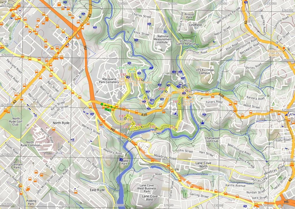
1 North Ryde Fairyland circuit 2 hrs 30 mins Hard track 6.9 km Circuit 193m 4 Starting at North Ryde train station this walk explores a stretch of the Lane Cove River, visiting the historic Fairlylands Pleasure Grounds along the way. The walk starts by wandering through the Riverside Corporate Park and soon comes alongside the Lane Cove River to join the Great North Walk. Here we follows the GNW though Fairylands before exploring a few streets in Chatswood West. After the weir, this walk leaves the main spine of the Great North Walk to explore the lovely River Side Track, through many picnic areas and up to the Lane Cove Tourist Park. Here the you wander along the roads back to the train station. Repeated keys in data Lane Maps, text & images are copyright wildwalks.com Thanks to OSM, NASA and others for data used to generate some map layers. Cove National Park

2 The Village Before You walk This pleasant shopping village is found at the intersection of Newbigin Cl and Julius Ave within the Riverside Corporate Park. The shopping complex is home to a couple of cafes, a chiropractor, copy centre and a few other shops. As this is in a corporate area, the shops are only open weekdays. Trebbiano Cafe PH: (02) Bushwalking is fun and a wonderful way to enjoy our natural places. Sometimes things go bad, with a bit of planning you can increase your chance of having an ejoyable and safer walk. Before setting off on your walk check Fairyland Once formally known as 'Fairyland Pleasure Grounds', and casually as 'The Rest', this site was similar to several others in Sydney. The land was purchased by Robert Swan in 1896 and encompassed about 17 acres in total. Part of the land was cleared for a market garden, growing strawberries and melons. By the early 1900s, the market garden had closed and the area had become a popular picnic and play ground, for people arriving mostly by boat. This was a very popular spot to visit for a special day out. Today, the buildings have (mostly) gone and the cleared area has grown back, but it still can offer a relaxing picnic and lunch spot by the river. Riverside Cafe Bar & Grill The Riverside Cafe is found at the end of service road on the southwest corner of Fullers Bridge. The nicely renovated building looks over the Lane Cove River and is open 7 days, serving breakfast, lunch and dinner. The food is cafe-style and meals are priced upwards from $13. Ph: (02) ) Weather Forecast (BOM Metropolitan District) 2) Fire Dangers (Greater Sydney Region) 3) Park Alerts (Lane Cove National Park) 4) Research the walk to check your party has the skills, fitness and equipment required 5) Agree to stay as a group and not leave anyone to walk solo Think before you TREK The 'Think before you TREK' program developed by NSW Police & NPWS promotes the benefits of planning ahead for your bushwalking trip by using an easy to remember acronym: adequate supplies of food, water, navigation and first T Take aid equipment. your planned route and tell friends and family when R Register you expect to return. beacon (PLB's) should be carried on walks with E Emergency significant gaps in mobile coverage (check terrain profile). to your planned route and follow the map and walking K Keep trails. Koonjeree Picnic Area Topo Maps Koonjeree Picnic Area is at the southern end of Lane Cove National Park, just near Fullers Bridge. The picnic area boasts free gas barbecues, flushing toilets, town tap water, picnic tables and shelters, a large open area and car parking. On the bank of the Lane Cove River, this is a pleasant spot to enjoy the park. The maps provided on wildwalks are helpful, but there are times where you may need maps covering a broader area. Maps that cover this walk include; 1: Map Series:91303N PARRAMATTA RIVER 1: Map Series:9130 SYDNEY Lane Cove Weir The Lane Cove River Weir was built in 1938 during the depression. The motivation for building the lake was to make the area more apealing for visitors' picnics. The weir created environmental issues such as silting and a decline in native fish populations. In much more recent years, a 'fish ladder' has been construcuted to allow fish to undertake their natural migration route for breeding. The weir proved an easy way for walkers to cross the Lane Cove River whilst enjoying the views up and downstream. Grade This walk has been graded using the AS The overall grade of the walk is dertermined by the highest classification along the whole track. 4 Grade 4/6 Hard track Length 6.9 km Circuit Time 2 hrs 30 mins Quality of track Rough track, where fallen trees and other obstacles are likely (4/6) Signs Directional signs along the way (3/6) Experience Required Some bushwalking experience recommended (3/6) Weather Weather generally has little impact on safety (1/6) Infrastructure Generally useful facilities (such as fenced cliffs and seats) (1/6)
3 Are you ready to have fun? Please ensure you and your group are well prepared and equipped for all possible hazards and delays. Check park closures, weather information and Fire Danger Rating before setting out. Optional side trips and alternate routes noted are not included in this walks overall grade, length or time estimate. Please allow extra time for resting and exploring areas of interest. The authors, staff and owners of wildwalks take care in preparing this information but will not accept responsibility for any inconvenience, loss or injury you may experience. Please take care, have fun - Happy Walking. Getting there You can get to North Ryde Train Station (gps: , ) by car, train or bus. Car: Parking fees apply in the area. This is a circuit, so you will finish back at the start. Find up to date and more information inlcuding; travel directions, weather, park closures and walker feedback at 0 North Ryde Train Station (870 m 15 mins) From the top of 'North Ryde' train station, this walk follows the footpath downhill beside Delhi Rd, past the bus stop. The footpath soon leads across a driveway with traffic lights then, about 200m from the train station, passes 'Delhi Convenience Store' (open 7am-7pm M-F & 10am-4pm weekends Ph: ). Soon after this shop, the walk crosses Julius Ave (at the traffic lights) to come to the intersection in front of the 'Riverside Corporate Park West Entrance'. Turn right: From the intersection, this walk follow the footpath beside 'Julius Ave' heading into the signposted 'Riverside Corporate Park West Entrance'. After about 150m, this walk veers left at the roundabout to continue along Julius Ave for another 400m, passing a few CSIRO and commercial buildings to come to the entrance of 'The Village' shopping complex (on your left) The Village This pleasant shopping village is found at the intersection of Newbigin Cl and Julius Ave within the Riverside Corporate Park. The shopping complex is home to a couple of cafes, a chiropractor, copy centre and a few other shops. As this is in a corporate area, the shops are only open weekdays. Trebbiano Cafe PH: (02) The Village (470 m 9 mins) Veer right: From the entrance of 'The Village' shopping complex, this walk follows Julius Ave north, initially keeping the 'The Village' on your left to almost immediately cross Newbigin Cl. About 65m further along the footpath beside Julius Ave, this walk come to an intersection, opposite 'Richardson Place'. Turn right: From the intersection, this walk crosses Julius Ave and follows the footpath beside Richardson Pl downhill. After about 70m, this walk turns right down the sealed driveway following the 'The Binary Centre' sign further downhill. After another 150m (just before the footpath ends), this walk crosses the road to come to an intersection with a faint track (in the bush on your left), just past the back corner of the 'Honeywell' building (partway around the right-hand bend, marked with a driveway dip in the gutter). Continue straight: From the intersection, this walk follows the footpath downhill beside the road for about 35m to pass the steps in front of the 'Binary Centre', where the walk continues a little further down the road (or steps) to come to the main car park entrance of the Binary Centre, just near the end of the road. Continue straight: From the intersection in at the start of the Binary/Goodman car park, this walk heads down through the middle of the turning circle at the end of the main road to follow the gravel/dirt trail, keeping the building to your left. About 80m from the end of the road, along this trail, this walk passes one track then comes to an intersection with a signposted track on (on your left) marked with a 'Scenic Trail' arrow post Wetland intersection (280 m 6 mins) Turn left : From the intersection, this walk heads along the narrower track, following the arrow post while keeping the buildings to your left. The track passes the 'How Does This Detention Basin Work?' information sign. The track then follows the black fence along the edge of the detention basin, passing the '0.6km Scenic trail' sign, then about 70m after this sign (after crossing flat timber bridge, this walk comes to an intersection behind the Binary Building where there are some concrete steps (on your left). Continue straight: From the intersection, this walk follows the track behind the Binary Building, keeping the building up to your left. After about 100m (just past the end of the building), this walk comes to an intersection at the bottom of some timber stairs (on your left), marked with a 'What can you See?' information sign. Continue straight: From the intersection, this walk follows the track gently downhill directly away from the Binary Building. The track soon leads under the high-tension power lines to merge with another track and come to an intersection marked with a GNW arrow post and a NPWS 'No dogs permitted' sign Int. Corporate Park Scenic Trail and GNW (420 m 10 mins) Continue straight: From the intersection, this walk heads away from the buildings and the high tension power line tower, following the GNW arrow post downhill and almost immediately crosses a small flat timber bridge. The rocky track leads up a short hill then the track starts to leads down for about 70m, where the track bends sharply right. Then the walk leads down a series of timber steps into the lusher forest and a 'Site of Fairyland Pleasure Grounds' information sign. Here the walk heads along the timber boardwalk, then follows the track past the 'Take Yourself Back to Fairyland' photo sign, and then onto an intersection beside a large palm tree. There is a 'Fairyland Pleasure Grounds' sign and short track on the right that leads to a seat beside Lane Cove River Fairyland Once formally known as 'Fairyland Pleasure Grounds', and casually as 'The Rest', this site was similar to several others in Sydney. The land was purchased by Robert Swan in 1896 and encompassed about 17 acres in total. Part of the land was cleared for a market garden, growing strawberries and melons. By the early 1900s, the market garden had closed and the area had become a popular picnic and play ground, for people arriving mostly by boat. This was a very popular spot to visit for a special day out. Today, the buildings have (mostly) gone and the cleared area has grown back, but it still can offer a relaxing picnic and lunch spot by the river Fairyland (490 m 10 mins) Continue straight: From the intersection at the centre of Fairylands, this walk follows the clear track whilst keeping the Lane Cove River through the trees to your right, past the 'Fairyland Pleasure Grounds' sign. The mostly flat track winds gently through the ferns to pass the 'Site of Fairyland Pleasure Grounds' information sign, then continues along the short timber boardwalk and up a series of timber steps. The now mostly-flat track leads along the side of the hill for about 150m, coming to a short track which takes this walk to an unfenced rock platform with river views (on your right). Continue straight: From the view point, this walk heads along the flat track whilst keeping the river below to your right. After about 100m, the track crosses a short section of timber boardwalk then leads past a series of National Park signs to come to a T-intersection with Quebec Rd (opposite number 101) Int. of Quebec Rd and Fairyland Track (550 m 12 mins) Turn left: From the intersection, this walk heads uphill following the GNW arrow post along Quebec Rd. At the top of the hill, the road bends right and comes to a signposted intersection, where this walk turn left to follow the GNW arrow post up what looks like a long sealed driveway. The walk follows Quebec Ave for about 300m past a couple of driveways (on your right) then below the fenced Northern Suburbs Memorial Gardens (on your left), coming to a turning circle and a locked gate at the end of the road End of Quebec Ave (400 m 8 mins) Continue straight: From the end of Quebec Ave, this walk follows the GNW arrow post around the locked gate and along the fairly flat, rocky track. After about 170m, this track leads to the edge of a large rock platform. From here, the walk tends right, going down through a gap in the rock then leading along the base of a short rock wall. The track then starts to lead more steeply downhill when, just after passing a small bench seat, the track leads down a steep stone staircase and then comes to a signposted Tintersection with River Rd (near Delhi Rd). Here, a 'Sydney Cove' sign points back up the hill. Continue straight: From the intersection, follows the GNW arrow post across River Ave, down along the minor road (keeping the busy Delhi Rd to your left). At the end of this minor rd this walk finds a footpath in front of 'Riverside Cafe Bar & Grill' Riverside Cafe Bar & Grill The Riverside Cafe is found at the end of service road on the south-west corner of Fullers Bridge. The nicely renovated building looks over the Lane Cove River and is open 7 days, serving breakfast, lunch and dinner. The food is cafe-style and meals are priced upwards from $13. Ph: (02) Riverside Cafe (120 m 1 mins) Turn left: From in front of 'Riverside Cafe Bar AND Grill', this walk follows the GNW arrow post and footpath under Fullers Bridge to an intersection with a set of steps just on the other side. Continue straight: From the intersection, this walk heads along the concrete footpath, away from the bridge, whilst keeping the river to your right. The path leads along the edge of 'Koonjeree picnic area' until just past the 'Crossing the Lane Cove River' information sign, where this walk comes to an intersection with another footpath (leading through the middle of the picnic area) Koonjeree Picnic Area Koonjeree Picnic Area is at the southern end of Lane Cove National Park, just near Fullers Bridge. The picnic area boasts free gas barbecues, flushing toilets, town tap water, picnic tables and shelters, a large open area and car parking. On the bank of the Lane Cove River, this is a pleasant spot to enjoy the park Koonjeree Middle Trk (100 m 2 mins) Continue straight: From the intersection, this walk follows the GNW arrow post along the concrete footpath, keeping the river just to your right. The path leads around the edge of the clearing and comes to a Tintersection with a road, just beside the weir (on your right) Lane Cove Weir The Lane Cove River Weir was built in 1938 during the depression. The motivation for building the lake was to make the area more apealing for visitors' picnics. The weir created environmental issues such as silting and a decline in native fish populations. In much more recent years, a 'fish ladder' has been construcuted to allow fish to undertake their natural migration route for breeding. The weir proved an easy way for walkers to cross the Lane Cove River whilst enjoying the views up and downstream Lane Cove Weir South
 and great views over the Lane Cove River.")
4 (520 m 9 mins) Turn left : From the southern end of the weir, this walk follows the sealed road up (away from the weir) for about 10m to turn right following the 'Riverside walking track' sign along the fenced timber boardwalk. After about 50m, this boardwalk leads past the fish ladder to come to a lookout (with stepped seats) and great views over the Lane Cove River. From the lookout, this walk continues along the boardwalk for about 80m (enjoying more river views) to then follow another 'Riverside walking track' sign along the edge of '3 Spoonbill' picnic area for about 130m, and come to '4 Illoura' picnic area (with toilets and water). This walk continues along the track beside the river for another 120m to pass below a large picnic shelter, then just over 100m later, this walk comes to the shop-front side of the sandstone boatshed building. 4.2 Lane Cove Boatshed Lane Cove Boatshed, in Lane Cove National Park, is situated on the bank of the (you guessed it) Lane Cove River. You can hire rowboats, kayaks, pedal boats, bikes and canoes, for different ways to enjoy the river. The shop also sells ice-creams, chips and drinks. The shed is open on weekend from 10am 5pm. During summer school holidays, the shop is also open from 12-5pm. For more info, call Greg on Boat Shed (690 m 13 mins) Continue straight: From the shop-front side of the boatshed, this walk follows the riverside track upstream, keeping the river just to your right. The track soon narrows and after about 80m, comes to a large clearing, the '7 Moola' picnic area (with toilets and water). The track leads over a small flat timber bridge in the middle of the picnic area to then find a NPWS arrow post on the far side. Here this walk follows the arrow along the track for about 70m to then climb up the metal staircase, where the track continues for another 180m, first up and over a rocky outcrop then along a flat track to find another large clearing. On the far side of this picnic area, just past the '8 Ironbarks' sign, this walk comes to a three-way intersection (with a concrete path on your left). Continue straight: From the intersection, this walk follows the NPWS arrow post along the narrow management trail, keeping the river to your right. After about 60m, this walk heads around a locked gate, then heads up over the grass to find a picnic area. Here the walk heads over the timber bridge, past the '9 Carters Creek' sign and into the picnic area. The walk veers left across the picnic area to come back to the car park, just below the toilet block on the far side of the picnic area Carters Creek Carters Creek Picnic Area is the ninth formal picnic space along this stretch of the Lane Cove River. This picnic area is home to a couple of sheltered picnic tables, a gas BBQ a large open grassy area, garbage bins, toilets and a car park. There is some limited access to the river view. A pleasant spot among the tall gums Carters Creek (360 m 6 mins) Continue straight: From the picnic area, this walk follows the NPWS arrow post across a small creek and up the footpath, away from the picnic area. From the the top of the small hill, the track now leads (keeping the river on your right) for almost 300m, passing through a re-vegetating tall gum forest then a pleasant she-oak stand, to come to a large gravel car park just before Cottonwood Glen picnic area Cottonwood Glen Cottonwood Glen picnic area is a large open grassy spot on the bank of the Lane Cove River. There is a grove of trees along the edge of the river, but you can still get clear views across the water from the car park area. There are several picnic tables and a small toilet block just up the hill Cottonwood Glen (380 m 8 mins) Turn left: From car park beside '13 Cottonwood Glen' picnic area, this walk follows the 'Lane Cove Tourist Park' arrow post up the road. This walk soon veers left to head up beside the '12 Blackbutt' picnic area, then up some steps to come to a signposted intersection with Riverside Drive. Continue straight: From the intersection, this walk follows the 'Tourist Park' sign gently up the track (away from the road) for about 30m to pass a 'Native Fauna' information sign and cross a small metal bridge beside the tall fern trees. Here the walk continues gently up through the forest for another 30m to pass the 'Bush Regeneration' information sign, then the track continues to wind gently uphill for almost 180m, passing the 'Native Flora' information sign and coming to a three-way intersection beside a large gum, where a sign points back down to 'Lane Cove River Weir' sign Int. Weir and Scribbly Gums picnic area trks (290 m 6 mins) Turn left: From the intersection, the walk heads uphill directly away from the face of the 'Scribbly Gums picnic area' sign and past the large scribbly gum. The track leads under a banksia tree and after about 40m starts to climb a series of stone steps. After climbing these steps for about 60m, this walk heads through a gap in a fence to come to the edge of the Lane Cove Tourist Park. From here, this walk head directly away from the face of the 'Lane Cove National Park' sign and straight up the internal road. This road soon bends left then leads though the campsite for about 100m before bending right just past the laundry. Here the walk heads up this road for about 50m, past the boom gates, to come to the front of the the 'Lane Cove Tourist Park' office Lane Cove River tourist park This is a well-established caravan park on the edge of Lane Cove National Park, offering a variety of camp sites from tent to powered sites for caravans and even en suite cabins. The campsite is a great point to access many wonderful walks in Lane Cove Valley. There are many facilities including a laundry, toilets, showers (including facilities for people with disabilities and with infants), recreation room, Internet kiosk (with free access to Wildwalks.com), wireless Internet, BBQ's and a pool. There is bike hire available and the reception has basic supplies for sale (bread, milk, snacks, newspapers) Lane Cove Tourist Park Office (1 km 18 mins) Turn left: From in front of the the Tourist Park office, this walk crosses the driveway then follows the 'Telephones' sign along the brick footpath (keeping the pool yard to your left). About 20m past the sign, this walk veers right at the Y-intersection and continues for another 40m to come to the phone box on Plassey Rd, where a 'Reception 25m' sign points back along the path. Veer left: From the phone box, this walk follows Plassey Rd south, heading directly away from the face of the 'Reception 25m' sign. After about 250m, this walk passes a 'Welcome to Lane Cove River Tourist Park' sign (on your left), then leads under the high-tension power lines. From here, the walk continues for another 220m then passes the entrance of 'Macquarie Park Cemetery and Crematorium'. Soon after passing this entrance, this walk follows the footpath on the left-hand side of the road for about 130m to then cross 'Delhi Rd' at the traffic lights and come to 'Riverside West Entrance' on 'Julius Ave'. Turn right: From the intersection, this walk crosses Julius Ave and follows the footpath alongside Delhi Rd (on the other side of the road from Macquarie Park Cemetery). After about 60m, this footpath leads past 'Delhi Convenience Store' (open 7am-7pm M-F & 10am-4pm weekends Ph: ) and continues (crossing a driveway with traffic lights) for about 200m to come to the entrance of 'North Ryde' train station.
5
6 Summary navigation sheet for the North Ryde Fairyland circuit km Up/Dwn Length Initial directions (Use full tracknotes and maps for more detail) Start North Ryde Train Station , (GR Parramatta River, ) 0.87 The Village , (GR Parramatta River, ) 1.33 Wetland intersection , (GR Parramatta River, ) 1.61 Int. Corporate Park Scenic Trail and Great North Walk , (GR Parramatta River, ) m 15 mins 470 m 9 mins 280 m 6 mins 420 m 10 mins From the top of 'North Ryde' train station, this walk follows the footpath downhill beside Delhi Rd, past the bus stop. Veer right: From the entrance of 'The Village' shopping complex, this walk follows Julius Ave north, initially keeping the 'The Village' on your left to almost immediately cross Newbigin Cl. Turn left : From the intersection, this walk heads along the narrower track, following the arrow post while keeping the buildings to your left. Continue straight: From the intersection, this walk heads away from the buildings and the high tension power line tower, following the GNW arrow post downhill and almost immediately crosses a small flat timber bridge m 10 mins 550 m 12 mins 400 m 8 mins 120 m 1 mins 100 m 2 mins 520 m 9 mins 690 m 13 mins 360 m 6 mins 380 m 8 mins 290 m 6 mins 1 km 18 mins Continue straight: From the intersection at the centre of Fairylands, this walk follows the clear track whilst keeping the Lane Cove River through the trees to your right, past the 'Fairyland Pleasure Grounds' sign. Turn left: From the intersection, this walk heads uphill following the GNW arrow post along Quebec Rd Powered by TCPDF ( From Fairyland , (GR Parramatta River, ) Int. of Quebec Rd and Fairyland Track , (GR Parramatta River, ) End of Quebec Ave , (GR Parramatta River, ) Riverside Cafe , (GR Parramatta River, ) Koonjeree Middle Trk , (GR Parramatta River, ) Lane Cove Weir South , (GR Parramatta River, ) Boat Shed , (GR Parramatta River, ) 9 Carters Creek , (GR Parramatta River, ) 13 Cottonwood Glen , (GR Parramatta River, ) Int. Weir and Scribbly Gums picnic area trks , (GR Parramatta River, ) Lane Cove Tourist Park Office , (GR Parramatta River, ) Continue straight: From the end of Quebec Ave, this walk follows the GNW arrow post around the locked gate and along the fairly flat, rocky track. Turn left: From in front of 'Riverside Cafe Bar AND Grill', this walk follows the GNW arrow post and footpath under Fullers Bridge to an intersection with a set of steps just on the other side. Continue straight: From the intersection, this walk follows the GNW arrow post along the concrete footpath, keeping the river just to your right. Turn left : From the southern end of the weir, this walk follows the sealed road up (away from the weir) for about 10m to turn right following the 'Riverside walking track' sign along the fenced timber boardwalk. Continue straight: From the shop-front side of the boatshed, this walk follows the riverside track upstream, keeping the river just to your right. Continue straight: From the picnic area, this walk follows the NPWS arrow post across a small creek and up the footpath, away from the picnic area. Turn left: From car park beside '13 Cottonwood Glen' picnic area, this walk follows the 'Lane Cove Tourist Park' arrow post up the road. Turn left: From the intersection, the walk heads uphill directly away from the face of the 'Scribbly Gums picnic area' sign and past the large scribbly gum. Turn left: From in front of the the Tourist Park office, this walk crosses the driveway then follows the 'Telephones' sign along the brick footpath (keeping the pool yard to your left).
Lane Cove Tourist Park River Circuit
 Lane Cove Tourist Park River Circuit 5 hrs 12 km Circuit Hard track 383m This walk follows a large section of Lane Cove River. The walk follows the Riverside Walking track up the Lane Cove River to De
Hunters Hill to Epping Road
 Hunters Hill to Epping Road 2 hrs 30 mins 5.5 km One way Moderate track 154m An enjoyable walk through lower sections of the Lane Cove National Park, this walk features plenty of mangroves next to the
De Burghs Bridge to Fullers Bridge
 De Burghs Bridge to Fullers Bridge 2 hrs 3 mins Hard track 6 km One way 2m 4 Following the Lane Cove River, this walk mostly follows a section of the Great North Walk and is well maintained and signposted.
Rail to River Walk. 3 hrs. Hard track 7.5 km Circuit. 222m
 Rail to River Walk 3 hrs Hard track 7.5 km Circuit 4 222m This walk is a great one from Chatswood Station to the Lane Cove River National Park. The walk descends through the vegetated bushland which fills
Morgans Creek to Padstow
 Morgans Creek to Padstow 2 hrs 45 mins 8 km One way Moderate track 3 144m This pleasant walk starts from the Morgans Creek park, at Henry Lawsons Drive, and follows the Georges River past the Boomerang
Sid Pulsford Walk. 175m. 33m. 1 hr 45 mins 4.1 km One way. Hard track 118m. Gosford LGA
 Sid Pulsford Walk 1 hr 5 mins.1 km One way Hard track 118m Sid Pulsford Walk explores the ridge top of Kincumber Mountain, from Honeman's Rock to Green Point. The walk mostly follows wide management trails.
Currie Rd to Davidson Park
 Currie Rd to Davidson Park 3 hrs 7.2 km One way Moderate track 28m Starting at Currie Rd in Forestville, this walk follows Middle Harbour to Davidson Park, under Roseville Bridge. There are two optional
Roseville to Macquarie Park
 Roseville to Macquarie Park 3 hrs 3 mins 8.8 km One way Hard track 4 29m This walk starts at Roseville station and explores the streets and alleyways of Roseville before joining the main spine of the Great
Epping to Pennant Hills Station (via Lane Cove River)
") Epping to Pennant Hills Station (via Lane Cove River) 3 hrs 5 mins 8.4 km One way Hard track 249m This walk, from Epping to Pennant Hills Station, is a great way to see the upper Lane Cove River Valley.
Epping to Pennant Hills Station (via Lane Cove River) 3 hrs 5 mins 8.4 km One way Hard track 249m This walk, from Epping to Pennant Hills Station, is a great way to see the upper Lane Cove River Valley.
Echo Point to Leura Forest via Three Sisters and Giant Stairs loop
 Echo Point to Leura Forest via Three Sisters and Giant Stairs loop 3 hrs 3.8 km Circuit Hard track 512m This walk starts from the popular Echo Point, in Katoomba, and winds down to the base of the Three
Wentworth Falls Conservation Hut Loop
 Wentworth Falls Conservation Hut Loop 3 hrs Hard track 6.7 km Circuit 4 341m This scenic walk from Wentworth Falls Station, winds along the Nature Trail to Conservation Hut, then drops into the magnificent
Little Digger Track to Davidson Reserve and Lyrebird Circuit
 Little Digger Track to Davidson Reserve and Lyrebird Circuit 4 hrs 3 mins 11.5 km One way Hard track 4 47m Exploring both the eastern and western sides of Middle Harbour Creek, this walk follows the Little
Gordon to Chatswood Station
 Gordon to Chatswood Station 4 hrs 30 mins 12.2 km One way Hard track 4 381m This walk is a great way to get into the bush without being far from civilisation. The walk wanders through untouched valleys
Popes Glen, Pulpit Rock, Govetts Leap and Braeside Walk
 Popes Glen, Pulpit Rock, Govetts Leap and Braeside Walk 8 hrs Hard track 13.6 km Circuit 4 1068m This large circuit walk, from Popes Glen to Pulpit Rock, Govetts leap and along the Braeside Track, passes
Govetts Leap Loop. 1065m. 909m Blue Mountains National Park. 4 hrs 30 mins 8.7 km Circuit. Hard track 380m
 Govetts Leap Loop 4 hrs 30 mins 8.7 km Circuit Hard track 380m This walk, from Blackheath Train Station, is a fantastic way to see some of the iconic areas of the Blue Mountains in the Blackheath area.
Teralba to Charlestown Park track head
 Teralba to Charlestown Park track head 4 hrs 30 mins 13.3 km One way Moderate track 3 220m This section of the Great North Walk starts from the Teralba train station and winds down and around the edge
Rail to River and Stringybark Creek Reserve Walk
 Rail to River and Stringybark Creek Reserve Walk 4 hrs Hard track 11.2 km Circuit 4 302m This walk begins in the busy city of Chatswood and soon enters the nearby bushland around the Lane Cove River. The
De Burgs Bridge to Thornleigh station
 De Burgs Bridge to Thornleigh station 3 hrs 45 mins 9.7 km One way Hard track 4 363m This walk follows a section of the Great North Walk, starting from De Burghs bridge. The walk winds north west, through
Epping to Eastwood Station (via Lane Cove River)
") Epping to Eastwood Station (via Lane Cove River) hrs 45 mins 10.2 km One way Moderate track 189m Epping to Eastwood, via Lane Cove River, is the longer route through the bush between the stations. This
Epping to Eastwood Station (via Lane Cove River) hrs 45 mins 10.2 km One way Moderate track 189m Epping to Eastwood, via Lane Cove River, is the longer route through the bush between the stations. This
The Basin Track and Mackerel Track
 The Basin Track and Mackerel Track 3 hrs 5.9 km Circuit Hard track 226m This walk is a great way to see some popular areas in Ku-ring-gai Chase National Park. The walk from West Head Rd travels to The
Waterfall to Heathcote
 Waterfall to Heathcote 5 hrs Hard track 10.8 km One way 4 467m This walk explores the heart of Heathcote National Park, and is easily accessed with a train station at either end. Although relatively close
The Foreshore Walk. 24m. 1m Lake Macquarie LGA. 1 hr 15 mins 2.9 km One way. Hard track 81m
 The Foreshore Walk 1 hr 15 mins 2.9 km One way Hard track 81m This walk traverses the coastline of the Green Point reserve. By following a variety of tracks and occasionally traveling inland through eucalyptus
Hornsby Blue Gum Walk
 Hornsby Blue Gum Walk 3 hrs Hard track 6.7 km Circuit 4 374m This delightful loop is one of the prettiest and most popular walks in the Hornsby area. Going from an environment of ferns and clear bushland
Little Digger Track. 68m. 1 Hr 2.2 km One way. Moderate track 93m. Moores Creek Reserve
 Little Digger Track Hr 2.2 km One way Moderate track 93m This walk follows Moores Creek through several reserves in east Roseville and East Lindfield. The track is named after Australia's 7th Prime Minster,
Carrington Park to Leura Forest and pass loop
 Carrington Park to Leura Forest and pass loop 3 hrs Hard track 4.8 km Circuit 4 674m This walk is a fantastic way to see Leura Forest. The walk descends from Carrington Park, visiting Leura Forest and
Heathcote to Engadine via Audley
 Heathcote to Engadine via Audley 6 hrs 3 mins 5 km One way Hard track 4 635m Covering a large section of central Royal National Park, this walk goes through the heath and scrub along a well managed and
Dead Horse Gap Loop track
 Dead Horse Gap Loop track 4 hrs 30 mins Hard track 9.8 km Circuit 144m 4 This walk starts with a ride up the Kosciuszko Express Chairlift. There is an opportunity to eat at Australia's highest restaurant,
Balmoral Beach to The Spit
 Balmoral Beach to The Spit 2 hrs 30 mins.3 km One way Hard track 85m This walks follows the coast from Balmoral to the Spit and across Spit Bridge. There are some alternate tracks to consider at high-tides,
Katoomba Falls Circuit
 Katoomba Falls Circuit hr 5 mins.5 km Circuit Hard track 59m For those looking for a walk involving more than simple boardwalk, this trail winding through the temperate rain forest could be just the thing.
Callicoma Loop. 174m. 98m. 2 hrs. Hard track 5.1 km Circuit. 153m
 Callicoma Loop 2 hrs Hard track 5.1 km Circuit 153m This great circuit walk passes through some really nice forest around the fringe of Cherrybrook. Highlights of the walk include some beautiful rock overhangs
Wattamolla to Big Marley Beach
 Wattamolla to Big Marley Beach 4 hrs 10.4 km Circuit Moderate track 4m This walk is an excellent loop which takes in both the coast and the heathy inland of Royal National Park. Nearly the whole walk has
Mackerel Beach, West Head Loop
 Mackerel Beach, West Head Loop 5 hrs 8.6 km Circuit Hard track 422m The Mackerel Beach, West Head Loop is a walk which explores a large part of the West Head. The journey starts and finishes with a ferry
Campbell Drive to Snapper Point
 Campbell Drive to Snapper Point 1 hr 45 mins 4.2 km One way Experienced only 135m This walk follows the Coast Track to Frazer Beach, along the Geebung and (overgrown) Grass Tree Tracks. From the northern
Woolwich Wharf to Boronia Park
 Woolwich Wharf to Boronia Park 2 hrs 5.8 km One way Moderate track 175m Going through the streets of Hunters Hill, this walk is on the first segment of the Great North Walk. The majority of the walk is
Wallarah Coastal Walk
 Wallarah Coastal Walk 3 hrs 8.3 km Return Hard track 247m This walk starts at Caves Beach and travels south along the coastline, until reaching the Pinney s Headland Lookout. There are many opportunities
Sphinx, Warrimoo and Bobbin Head tracks
 Sphinx, Warrimoo and Bobbin Head tracks 4 hrs 9.6 km Circuit Moderate track 499m This great walk starts at the Sphinx Memorial and loops around via Cowan Creek, exploring diverse environments as it changes
Epping to Gordon Station
 Epping to Gordon Station 4 hrs 15 mins 11.7 km One way Hard track 4 365m This walk, from Epping Station to Gordon Station, passes below the homes which sit on the hills high above the Lane Cove River.
Green Point Circuit Walk
 Green Point Circuit Walk 3 hrs 7.7 km Circuit Hard track 269m This walk visits all of the popular locations in Green Point Reserve, as well as some of the lesser-visited areas inland. Taking in Sea Eagle
Berowra to Mt Kuring-gai
 Berowra to Mt Kuring-gai 4 hrs 30 mins 9.4 km One way Hard track 4 551m From the ridges above Cowan Creek, this walk takes in some great lookouts (especially around Mt Kuringgai) as well as enjoying an
Middle Harbour Creek Loop
 Middle Harbour Creek Loop 5 hrs 45 mins 15.1 km Circuit Experienced only 5 570m This walk explores the upper reaches of Middle Harbour Creek, starting and ending at the great parklands at Davidson Park,
Mackerel Beach and Resolute Loop
 Mackerel Beach and Resolute Loop 3 hrs 5.4 km Circuit Hard track 384m This walk is another great walk in Ku-ring-gai Chase National Park, accessed by ferry. From the Mackerel Beach wharf, this walk uses
Scenic World to Echo Point
 Scenic World to Echo Point 1 hr 15 mins 2.1 km One way Moderate track 192m This is one of the most popular tourist walks in the Katoomba area. The walk follows the cliffs along a well maintained and signposted
Under and Over Cliff Walk
 Under and Over Cliff Walk 4 hrs 9.4 km Circuit Moderate track 576m This walk from Wentworth Falls Station is a fantastic way to see a large majority of the Wentworth Falls cliffline. The track winds under
Bouddi Coastal Walk. 5 hrs. Hard track 8.1 km One way. 364m
 Bouddi Coastal Walk 5 hrs Hard track 8.1 km One way 4 364m This is one of the longer walks in the Bouddi National Park and it is rich in scenery. The walk follows the coastline with many side trips to
Glenbrook and Euroka Circuit
 Glenbrook and Euroka Circuit 2 Days 16.6 km Circuit Experienced only 790m This two day circuit, returning to Glenbrook Station, is a scenic walk which passes many of the tourist attractions within the
Spit Bridge to Middle Head Forts
 Spit Bridge to Middle Head Forts 2 hrs 30 mins 6.3 km One way Hard track 4 181m This scenic walk takes you from the Spit Bridge, along the coast to explore the Middle Head Forts. There are a few alternate
Upper Rumbalara circuit
 Upper Rumbalara circuit 1 hr 30 mins 3.3 km Circuit Hard track 176m A great circuit walk, covering most of the walking tracks and sights in the upper section of the Rumbalara Reserve. There is some really
Patonga to Woy Woy. 5 hrs 45 mins 15.5 km One way. Hard track. 497m
 Patonga to Woy Woy 5 hrs 45 mins 15.5 km One way Hard track 4 497m This walk explores a variety of environments from the shore line and coastal cliffs near Patonga, to the dry, rocky and open ridge line.
National Pass from Wentworth Falls to Conservation Hut
 National Pass from Wentworth Falls to Conservation Hut 3 hrs Hard track 3.6 km One way 739m Starting at Wentworth Falls picnic area, this scenic and historic walk explores many waterfalls, lookouts and
Taronga Wharf to Chowder Bay
 Taronga Wharf to Chowder Bay 2 hrs 4.4 km One way Moderate track 246m Starting at Taronga Wharf, this walk passes many icons of Sydney, including Taronga Zoo, HMAS Sydney Mast, Chowder Bay. The walk also
Wentworth Falls Station Loop (Undercliff Walk)
") Wentworth Falls Station Loop (Undercliff Walk) 4 hrs 3 mins Hard track 8.9 km Circuit 658m 4 This walk passes some stunning waterfalls and views into the Jamison Valley, following the cliff edges around
Wentworth Falls Station Loop (Undercliff Walk) 4 hrs 3 mins Hard track 8.9 km Circuit 658m 4 This walk passes some stunning waterfalls and views into the Jamison Valley, following the cliff edges around
Blackheath Station to Junction Rock Loop (via Grand Canyon and Popes
 Blackheath Station to Junction Rock Loop (via Grand Canyon and Popes 8 hrs 30 mins 18.2 km Circuit Hard track 4 1254m This circuit starts in Blackheath and heads down into the Grand Canyon and Rodriguez
Sydney to Thornleigh via Lane Cove Tourist Park
 Sydney to Thornleigh via Lane Cove Tourist Park 2 Days 33 km One way Hard track 4 1114m This overnight walk starts from the Obelisk in Macquarie Park, Sydney, at the official start of the Great North Walk.
Dubbo Gully and Ten Mile Hollow Circuit (via Clares Bridge)
") Dubbo Gully and Ten Mile Hollow Circuit (via Clares Bridge) 2 Days Hard track 24.3 km Circuit 4 1117m This two day (or ten hour) walk follows several historic roads, now closed to traffic. Starting with
Dubbo Gully and Ten Mile Hollow Circuit (via Clares Bridge) 2 Days Hard track 24.3 km Circuit 4 1117m This two day (or ten hour) walk follows several historic roads, now closed to traffic. Starting with
Hermitage Foreshore Track
 Hermitage Foreshore Track 1 Hr 2.2 km One way Moderate track 123m The Hermitage Foreshore Walk is a wonderful way to explore Sydney Harbour from the perspective of South Head. This walk starts from Nielsen
Chatswood to Epping Station
 Chatswood to Epping Station 6 hrs Hard track 16.3 km One way 4 533m This walk, from Chatswood to Epping, is a long but enjoyable walk along the Lane Cove valley. The walk mostly follows the Lane Cove River
Charlestown Park trackhead to Newcastle station
 Charlestown Park trackhead to Newcastle station 5 hrs 30 mins 12.1 km One way Hard track 4 287m This section of the Great North Walk starts from the Charleston Park track head and winds through the streets
Federal Pass Walking Track
 Federal Pass Walking Track 5 hrs Hard track 8 km One way 4 989m This classic trail follows along the base of the cliffs from Leura to the Golden Stairs, passing many of the more popular sights of the Katoomba
Thornleigh to Hornsby
 Thornleigh to Hornsby 4 hrs Hard track 10.2 km One way 4 526m Starting at Thornleigh station you walk through suburban streets for a short while before diving into the bush at the southern end of Berowra
Echo Point to Leura Forest Circuit
 Echo Point to Leura Forest Circuit 3 hrs 4.8 km Circuit Hard track 588m Forming a circuit around the cliffs and then the valley floor, this is a walk more then capable of convincing a walker of the beauty
Sphinx to Mt Kuring-gai
 Sphinx to Mt Kuring-gai 4 hrs 45 mins 1.7 km One way Hard track 673m This walk starts at the Sphinx War Memorial and follows some well maintained and popular walking tracks down to Cowan Creek. Enjoy the
Wentworth Falls Station Loop
 Wentworth Falls Station Loop 5 hrs 3 mins 9.5 km Circuit Hard track 4 13m The Wentworth Falls Station Loop takes in most of the upper tracks around Wentworth Falls. There are many scenic views near the
Wentworth Falls Loop. 893m. 665m. 6 hrs 10.2 km Circuit. Hard track 1093m. Blue Mountains National Park
 Wentworth Falls Loop 6 hrs 1.2 km Circuit Hard track 193m This is a great walk, both in size and spectacular views. The walk makes its way from Wentworth Falls train station and drops off the plateau,
Rumbalara Explorer. 158m. 5m Rumbalara Reserve. 2 hrs 45 mins 6.1 km Circuit. Hard track 326m
 Rumbalara Explorer 2 hrs 5 mins 6.1 km Circuit Hard track 326m Pretty well the grand tour of the Rumbalara Reserve, this walk takes in much of the great scenery the reserve has to offer. The walk covers
Spit Bridge to Manly (Manly Scenic Walkway)
") Spit Bridge to Manly (Manly Scenic Walkway) 3 hrs 45 mins 9.1 km One way Moderate track 349m The Spit to Manly walk is a classic bushwalk on Sydney's Northern Beaches. The walk follows a well-maintained
Spit Bridge to Manly (Manly Scenic Walkway) 3 hrs 45 mins 9.1 km One way Moderate track 349m The Spit to Manly walk is a classic bushwalk on Sydney's Northern Beaches. The walk follows a well-maintained
Bobbin Head Loop. 166m. 0m Ku-ring-gai Chase National Park. 5 hrs 12.9 km Circuit. Hard track 619m
 Bobbin Head Loop 5 hrs 12.9 km Circuit Hard track 619m This great circuit walk enjoys a variety of landscapes in Ku-ring-gai Chase National Park. The walk starts at the historic Sphinx war memorial and
Narrabeen Lagoon Trail (from Middle Creek)
") Narrabeen Lagoon Trail (from Middle Creek) 2 hrs 30 mins 8.6 km Circuit Very easy 1 105m The Narrabeen Lagoon Trail is a wonderful and accessible walk on the Northern Beaches of Sydney. The trail is used
Narrabeen Lagoon Trail (from Middle Creek) 2 hrs 30 mins 8.6 km Circuit Very easy 1 105m The Narrabeen Lagoon Trail is a wonderful and accessible walk on the Northern Beaches of Sydney. The trail is used
Gosford to Lisarow. 202m
 Gosford to Lisarow 4 hrs 3 mins Hard track 11.3 km One way 4 479m This walk is a great way to explore the ridge-top bushland between Gosford and Lisarow. Passing through Rumbalara and Katandra Reserves,
Faulconbridge to Blaxland
 Faulconbridge to Blaxland 2 Days Experienced only 15.2 km One way 5 693m This two-day walk, or very solid one-day walk, takes you from station to station, through lush, scenic forest in the lower Blue
Cape Banks Circuit. 50m. 2m Botany Bay National Park. 3 hrs 7.3 km Circuit. Hard track 190m
 Cape Banks Circuit 3 hrs 7.3 km Circuit Hard track 19m This Cape Banks Circuit has a lot to offer and is thoroughly recommended. The walking travels over beaches, through coastal forest and across exposed
The Coast Track. 2 Days. Hard track 27.4 km One way. 1351m
 The Coast Track 2 Days Hard track 27.4 km One way 4 1351m Heading south, this walk covers the coastline of the Royal National Park and can truly only be described as amazing. With breathtaking coastal
Scenic world to Three Sisters Loop via Furber Steps
 Scenic world to Three Sisters Loop via Furber Steps 5 hrs 5.8 km Circuit Hard track 722m This walk starts from the popular Scenic World, in Katoomba, and winds down the Furber steps into the Jamison Valley,
Bouddi Ridge and Coastal Walk
 Bouddi Ridge and Coastal Walk 2 Days Hard track 27 km Circuit 4 126m This overnight walk takes in the majority of the magnificent Bouddi National Park. The walk starts from the pleasant Putty Beach camping
Taronga Zoo to Spit Bridge
 Taronga Zoo to Spit Bridge 5 hrs Hard track 1.4 km One way 4 41m This is a scenic and culturally rich walk with views over Sydney Harbour and many interesting heritage buildings along the way. The start
Manly to Seaforth Oval
 Manly to Seaforth Oval 5 hrs 45 mins 13.7 km One way Moderate track 3 624m This walk follows the Manly to Spit Scenic Walkway, then continues past The Spit Bridge to Seaforth Oval. The walk provides magnificent
Six Foot Track. 1212m
 Six Foot Track 3 Days 44.8 km One way Hard track 4 2066m This classic walk takes you from Katoomba to Jenolan Caves via a historic horse route. The walk travels mainly along well-maintained service tracks
Light to Light Walk 2 days
 Light to Light Walk 2 days 2 Days Hard track 3.9 km One way 4 794m Over two days, this classic walk explores the coast from Boyd Tower to the Green Cape Lighthouse in the south. Hegartys Bay Camp is over
Harbour Bridge to Taronga Zoo
 Harbour Bridge to Taronga Zoo 4 hrs 9.8 km One way Moderate track 389m On this walk, you will explore much of the foreshore linking Milsons Point Station to Taronga Zoo Ferry wharf. The walk is mostly
SELF GUIDED TOURING ROUTE
 SELF GUIDED TOURING ROUTE Things to see and places to go on the loop from Orbost to Marlo, Cape Conran, Cabbage Tree and back to Orbost (or onwards to Cann River) V6 April 2017 This guide should be read
Beautiful Walks from the Blue Ball Inn
 Walk No. 7 COAST AND VALLEY WALK Countisbury, Glenthorne, County Gate, Brendon, Rockford and Wilsham 10 MILES APPROX. Walking time 5 hours approx. (not including breaks)> OS Sheet 64/74 Lynton and Lynmouth.
NEWLANDS CORNER AND ST MARTHAS
 NEWLANDS CORNER AND ST MARTHAS 10k CIRCULAR ROUTE 2½-3HRS GU4 8SE From Newlands Corner on the North Downs just outside Guildford, you can enjoy one of the most beautiful panoramas of quintessential English
Hammer Vale and Linchmere Common
 point your feet on a new path Hammer Vale and Linchmere Common Distance: 9 km=5½ miles or 6 km=3¾ miles easy walking with one steep section Region: Hampshire, West Sussex Author: Botafuego Refreshments:
Access Statement for Loch of Strathbeg
 This access statement does not contain personal opinions as to our suitability for those with access needs, but aims to accurately describe the facilities and services that we offer all our guests/visitors.
ULTRA-TRAIL AUSTRALIA May 2018 COURSE DESCRIPTION AND COURSE NOTES
 ULTRA-TRAIL AUSTRALIA 100 19-20 May 2018 COURSE DESCRIPTION AND COURSE NOTES LEG 1 Scenic World (Start) to Narrow Neck (Checkpoint 1) Course Description: From the start, at the front entrance of Scenic
Loch Ness Shores Club Site
 Loch Ness Shores Club Site Camping and Caravanning Falls of Foyers Route Summary A strenuous walk from Loch Ness Shores Club Site. The route climbs through forest to The Upper Foyers Waterfall and then
A Walk from Our Lady of Victories Church, Bowen Hills to The Cathedral of Saint Stephen
 A Walk from Our Lady of Victories Church, Bowen Hills to The Cathedral of Saint Stephen 1 0.0km 30m 185m 270m From the Start to Breakfast Creek Rd is 8 minutes This pilgrimage walk should take the average
Directions for Day 1: Colwood To Metchosin
 Colwood-Metchosin Page 1 of 8 Directions for Day 1: Colwood To Metchosin Start: Royal Roads University, Birds of a Feather B&B, or at Esquimalt Lagoon Finish: Your accommodation in Metchosin Time: 4-5
Walk: NOC 08 Location: Cym Glyn near Brecon
 33 Walk: NOC 08 Location: Cym Glyn near Brecon Directions: Not easy to find at all. Go to Libanus, then head towards Brecon on the A470. Take minor C road single track lane first right as you come out
THE WELLDIGGERS ARMS, HESWORTH AND FITTLEWORTH TRAIL
 THE WELLDIGGERS ARMS, HESWORTH AND FITTLEWORTH TRAIL 5.5 miles Circular 3 hours 041017 Challenging Terrain A 300-year-old pub turned country-inn on the edge of the South Downs National Park, The Welldiggers
The Hundred Parishes
 The Hundred Parishes Walks from railway stations number 9 6.4 miles (10kms) from Bishop s Stortford to Stansted Mountfitchet Start: Bishop s Stortford station (Grid Reference TL492209) (ample parking and
RILLINGTON TO MALTON by Tania Dickinson
 RILLINGTON TO MALTON by Tania Dickinson This walk takes you from the Vale of Pickering up on to the Wold scarp, before dropping down again through the pretty village of Settrington and joining the Centenary
8 Miles Circular 4 hours
 VISIT RYEDALE HELMSLEY AND RICCAL DALE 8 Miles Circular 4 hours 090616 Challenging Terrain An 8 mile (13km) circular walk from the market town of Helmsley in Ryedale. The route heads out across sheep pastures
The Mendip Way. Route Directions and Maps Wells to Frome
 The Mendip Way Route Directions and Maps Wells to Frome Website: www.mendiphillsaonb.org.uk Email: mendip@mendiphillsaonb.org.uk Facebook & Twitter: @MendipHillsAONB Phone: 01761462338 1 Wells to Shepton
Leg #1 (GUNLOCK AND LOADED) Miles
 Miles") Leg #1 (GUNLOCK AND LOADED)- 6.07 Miles Difficulty: Easy to Moderate This is a nice leg for those who like running downhill. It s a beautiful run down the Santa Clara River canyon to the point where the
Leg #1 (GUNLOCK AND LOADED)- 6.07 Miles Difficulty: Easy to Moderate This is a nice leg for those who like running downhill. It s a beautiful run down the Santa Clara River canyon to the point where the
ST. AGNES. you cannot put a time limit on beauty.
 ST. AGNES CIRCULAR WALKS AROUND There are many enjoyable and picturesque walks around St. Agnes most are signposted and are featured on the St. Agnes Mini-guide map. Because most of our footpaths are in
Start / Finish. Version 2
 Start / Finish Version 2 Gosford (Start) to Woy Woy Head South down Etna Street, crossing Henry Parry Drive, then Mann St, Gosford, where Etna St becomes Racecourse Road. Follow this road all the way
Approximate distance: 5.5 miles For this walk we ve included OS grid references should you wish to use them. Start. End
 Approximate distance: 5.5 miles For this walk we ve included OS grid references should you wish to use them. End 4 1 Start 3 2 N W E S Reproduced by permission of Ordnance Survey on behalf of HMSO. Crown
Tideswell to Castleton
 Tideswell to Castleton 1 Walk summary Length: 14 km, 8.5 miles Maps: OS Explorer OL1 The Peak District - Dark Peak Area, OS Explorer OL24 The Peak District - White Peak Area, OS Landranger 110 Sheffield
MAPS & WALK NOTES. DAY 2: Greenwich Wharf to Woolwich Wharf
 MAPS & WALK NOTES DAY 2: Greenwich Wharf to Woolwich Wharf Total Distance: 15.5km Time: Approximately 5 hours 30 mins five Sections Walk Notes in Section Name Length Time 2:1 Greenwich Wharf to Northwood
The Year Of Mercy Pilgrimage Sts Peter and Paul s Church, Bulimba To The Cathedral of St Stephen
 The Year Of Mercy Pilgrimage Sts Peter and Paul s Church, Bulimba To The Cathedral of St Stephen Dist Route Photos Photos 0.0km St Peter and Paul s Church, 235 Riding Rd & Cnr Main Ave, Balmoral. http://www.bulimbacatholic.com/