WARDIE PRIMARY SCHOOL TRAVEL PLAN
|
|
|
- Gerald Gray
- 5 years ago
- Views:
Transcription

1 WARDIE PRIMARY SCHOOL TRAVEL PLAN WARDIE PARENT COUNCIL
2 Contents Page Executive Summary 3 Section 1 - Introduction 4 Section 2 - Description of the school and surrounding area 4 Section 3 - Results from Pupil Travel Survey (including parents/carers 7 accompanying pupils) 3.1 Distance from home How the surveyed children get to school Reasons for method of travel choice Streets that are difficult to cross Cycling to and from school Problems with traffic around the school gates Other problems mentioned What would encourage change away from car use? Potential solutions within the survey 12 Section 4 - Conclusions and Action points 13 Table 1 15 Appendix
3 3
4 Wardie Primary School Travel Plan Executive Summary This travel plan is a follow up to the previous plan from The plan has been written by the parent council using data collected from a school wide travel survey that was completed in The survey has been analysed to produce graphs an statistics and some of which are in this plan. Of equal importance to this analysis are the views of parents and to reflect this a number of direct (anonymised) quotes have been included. The catchment area at Wardie Primary School is compact with more than 90% of pupils living less than one mile from the school. Therefore it is not surprising that over 80% of pupils walk or scoot to school. Car use was at 10% in the survey and its use was mainly to facilitate onward travel by the parent or carer to work. Of concern were the small number of people cycling to school. Reasons for not cycling relate to traffic volume and speed around the school and in the wider area with particular hotspots that are mentioned in the document. The traffic concerns are echoed by those walking or scooting to school with a number of roads being difficult to cross. With the rising school roll and the new nursery, particular strain has been put on the school gate and alternative measures have been looked at to access the school. Considerable concerns have been expressed about the risks to children caused by vehicle drivers close to the school. The table at the end of this document summarises the action points generated by the report. All of the action points have the aim of allowing our children to travel to and from school by walking, scooting and cycling in a safe and pleasant environment. It is hoped that these actions can be prioritized and resourced over the next few years, led by the parent council and involving the wider community. 4
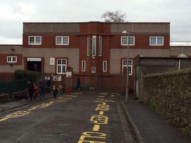
5 Section 1 - Introduction This is Wardie Primary School s first Travel Plan since The school has significantly grown since then. Because of this rise in the school roll, there has been, over the past few years, an increasing concern, apparent in several consultations with parents, about congestion or risks to safety when traveling around the school. These concerns were made explicit in responses to the Travel Plan survey that was carried out during This travel plan aims to summarise the points made and propose actions that can address them. Actions mainly consist of measures and initiatives to reach one or more of these goals: 1) Reduce unnecessary car use 2) Encourage healthy and sustainable travel options 3) Increase safety for children getting to and from school These goals are in accordance with the school ethos as an eco-school. This plan contains analysis of the present situation then proposes measures will include walking initiatives, cycling promotion as well as physical changes that include engineering or aspects of visual improvement. Proposed actions may also include educational programmes aimed at behaviour change. Their implementation may well need to be subject to ongoing collaboration between the school, the parent body, the local authority Children & Families Department and other departments in the local authority such as Travel or Placemaking. It may be that other third sector organisations such as Sustrans could be asked to help achieve some aspects of this plan. Section 2 - Description of the school and surrounding area From August 2016 Wardie Primary School is projected to have 570 pupils organised into 20 classes. The pupils range in age from 4 1/2 12 years old. There has been steady growth for the past 5-8 years with a block built and opened in 2008, another in 2013 and more in As of Summer 2015, the school also encompassed an integrated nursery that has an additional 40 children aged 3 to 5. In comparison, the school roll in 2005 was estimated at around 370 and it did not rise above 400 until around In summary the school has 200 more children compared to when the last travel plan was written in The school buildings are surrounded by a tarmac playing area plus areas of grass and perimeter woodland where the children are able to play. The building is set back from Granton Road, a busy main road used by all vehicle types: private cars, buses, vans and some lorries. 5


6 Approach to the school The pedestrian entrance to the building is by a small cul-de-sac where a gate is generally locked although it is often opened at start/end of school day to ease congestion. The vehicle entrance is shared by Edinburgh Council to access Broughton playing fields to the north of the school perimeter. There is a car park to the side used by school staff. The gate to these car parks is locked at beginning and end of the school day to ensure that no children are dropped off here. This, and the fact that Granton Road is an extremely busy road with double yellow lines along much of its length, means there are limited safe parking places around the school. The road has become busier in recent years likely to be due to more development of the Waterfront area, general densification of the north of the city and a likely increase in average household car ownership. After pressure from the Parent Council the council widened the Granton Road pavement for around 50m+ to the south of the school entrance during the summer of This has improved the route towards the school from this direction, especially reducing the congestion around the bus stop. Despite some concerns, there has been no discernable problem with the flow of any motor traffic by taking away some carriageway space. Further around the school Most streets around the school are narrow residential streets that have speed cushions. These cushions or humps promote appropriate lower-speeds to make it more favourable for children to play out on pavements at least, and sometimes on the street. Although the widespread on-street parking as well as the perceived risk of the occasional inconsiderate speeding driver means that, like many urban 6
7 areas, the parents of children are often not keen on permitting street play. All streets around have many driveways where cars can cross the pavements, and this is perceived as an additional risk to parents when considering whether to let their children walk to school independently or not. In front of the school is a crossing with traffic signals including red-green man system. This is staffed by a school crossing attendant during drop off and pick up times. Other attendants exist at the junction of Granton Road with Afton Terrace, at the junction of Cargil Terrace and South Trinity Road. [check?]. Out of normal hours activity For many years the school has had a very popular After School Club (Monday- Thursday) until 5:30pm. A Breakfast club is also now available as is an alternative after school club in the Wardie Residents Club adjacent to the north of the school. Very many after school clubs and activities run at all times of the year. The out of normal hours activity means that pupils and carers are accessing the school regularly before and after normal school hours. A particular time of increased risk is during winter months when it is dark at 4-5pm and some children will be leaving school grounds, with or without parents/carers and when there are no crossings guides. 7

8 Section 3 - Results from Pupil Travel Survey (including parents/carers accompanying pupils) There were 129 responses to the online survey. The responses were largely from the parents of younger children at the school with responses reducing from parents/carers of pupils in P5-P7. A full list of the survey questions are in appendix 1 (page 17) Distance from home to school (Analysis of Question 2) Observations The school has a tight catchment with the vast majority of children within an easy active travel distance. 93% of pupils live less than 1 mile from the school, with 60% living less than half a mile from the school. Only 6% of pupils live between 1-2 miles and 1% of pupils parents surveyed lived more than 2 miles from the school. Figure 1: Distances children travel to the school 3.2. How the surveyed children get to school (Analysis of Question 3) 61% walked to school, 22% scooted, 10% travelled by car (* but this is contradicted later on Q11 where 26% walk then drive at least sometimes during each week), 3% cycled and 2% used the bus (Figure 2). These data compare favourably to the 2005 survey where 35% of children traveled to school by car and 52% of children walked with the remaining children arriving by bus (5%) or cycling (8%). 8

9 Figure 2: Mode of transport to the school Observations Car use has fallen from 2005 to a low 10% but on occasion this figure will likely be higher largely due to parents dropping children off and then travelling onto work by car. A marked growth in scooter use was observed along with a decrease in cycling confirming the impact of busier roads around the school and the perceived need for pupils to travel on pavements, thus reducing risk while travelling. Scooting can be done safely on pavements whereas cycling is seen as unsafe. There has also been the investment in scooter shed and while the school has a reasonably well-covered bike shed it does not have so much capacity. Finally, in the past decade many more cheap, good quality scooters have become available Reasons for method of travel (mode) choice (Analysis of Question 4) 60% live close and state this as the reason for their choice in question 3 with 25% saying they enjoy walking (or cycling). A consistent 10% state that they take the car as they need to travel onto work. Going on to work was the major reason given for traveling to school by car. 9
10 3.4. Streets that are difficult to cross (Analysis of Question 6) 53% felt roads were difficult to cross and this was a barrier to walking, cycling or scooting. A large number of respondents (nearly half) listed around 70 hotspots that are grouped as follows. If these are deemed hard to cross, pedestrians are clearly not being given priority. The Scottish Government s street design policy states that pedestrians should come first. Therefore there is a policy justification for addressing pedestrian concerns in these areas. The diagram below is arranged around Granton Road with numbers of mentions and the main points for each area. Figure 3: Summary of issues around crossing streets NORTH of G Rd 4 Granton Square / Boswall Road No defined crossings WEST of G Rd (16 total) 9 Boswall Green Cars on pavements / Inconsiderate parking 7 Boswall Parkway/ Wardie Crescent No defined crossings GRANTON ROAD (14 total) Busy traffic See answers to question 8 (section 3,6) SOUTH of Gr Rd 9 Ferry Road/ Inverleith Row/Place Drivers passing through crossings when pedestrians have right of way EAST of G Rd (23 total) 10 Afton Terrace/ Cargil Terrace Rat run with impatient drivers 10 Netherby Road / Stirling Road / South Trinity Road / Darnell Road No traffic lights 3 Clark Road busy, no lights. 10
11 Direct quotes from responses to the question about difficult streets to cross: Afton terrace at the corner of Granton road feels particularly unsafe. It is manned by a crossing lady but regularly she has to step out from between parked cars as people park right along and even up to the corner - think some yellow Zig zags could help? Boswall green is busy with lots of parked cars and traffic coming from all four directions Cars travel too fast, cars parked near street corners making visibility difficult Wardie Crescent - can be quite busy and there are always cars parked on roadside No pedestrian crossing on Wardie Road. Very busy at rush hour. Boswell Green and Granton Road. Poor parking from other parents on pavements. This causes congestion and results in near misses. T-junction of Cargil Terrace with Wardie Road hard to cross (traffic comes from three directions and is busy plus lots of parked cars obstructing views). Crossing Afton terrace o.k. if cross with lollipop lady. Otherwise difficult as busy and lots of parked cars. We live at corner of Granton/Ferry Rd and there is one road that I worry about my children crossing. It is Rosebank Road and is a very busy road for kids to cross Rose bank road, used a lot by commuters and can be blind due to parked cars. Would not let child cross this alone till much older - unfortunate as rest of journey is safe. Ferry road - cars skip through the green man. Clark road, South trinity road, parked cars and v busy Crossing by entrance to school car park. Illegal/ inconsiderate parking blocking sightline. Lower Granton Road - Granton Square. Very busy in the mornings. Difficult roundabout to negotiate on foot. Most drivers do not give way to pedestrians to cross. The crossroads at East Trinity/South Trinity junction. There is no longer a lollipop lady there Concerns about cycling to and from school (Analysis of Question 7) 43% of respondents reported problems with cycling. Cycling encapsulates lots of concerns parents have about travel to school with the roads being too busy to cycle on safely with cars and the pavements too busy with pedestrians and children scooting for bicycles. The roads mentioned as being difficult for cyclists were the same as those mentioned above which were difficult for children walking or cycling to school to cross. Given the short distances most children travel to school safer cycle routes be in discussed in the long-term strategy in this document Problems with traffic around the school gates (Analysis of Question 8) Over 2/3 of the respondents reported problems with the traffic around the school gates. Quotes from the survey are below. A lot of these relate to speed and volume of car traffic on Granton Road along with inconsiderate parking. Direct quotes from responses to the question about problems with traffic around school gates: Cars parking on double yellow lines on Granton Road & school zone. This is not effectively patrolled 11
12 Too many parents drive. As you approach the school on Boswall Green there are cars parking and pulling out everywhere. There are also problems in the rugby club car park next to the school which is an exit for many parents walking to nursery. Cars should be banned in the morning from both of these spots. Not so much by gates but yes by the small car park area to side by residents club this area is a hazard for parents just dump their cars here at inappropriate places. Delivery vans for businesses opposite the school parking at the school entrance on the pavement. Provide a delivery parking bay on the West side of Granton Road for the chemist. Some people drop children in places where they're not supposed to stop and when challenged swear at you Very busy, cars drive too fast down Granton Rd and try to skip traffic lights. Because there are traffic lights at the school I don't see the traffic as being too big an issue. the paths do get very congested however as the kids queue up to cross the street. Think there are too many parents parking close to the school, double parking and driving too quickly along residential roads. Yes. People still park down the school entrance lane. The gate into school is too narrow. A bad bottleneck. Yes too much congestion at peak times going through one gate very often. 3.7 Other problems mentioned (including any other part of your child s journey that worries you / any other significant points raised (Analysis of Questions 9, 14 & 16)) Direct quotes from responses I strongly re opening the gate at Afton terrace would assist with some of the congestion. Making it easier for the footfall coming from that side of trinity and inverleith to be in the school grounds sooner, avoiding busy traffic and parked vehicles. In particular now that there is a school nursery it would also give our smallest pupils a safer route into the school grounds. I think they should open up the other entrance to the school to ease the morning and after school congestion. Why not move the school entrance? There is another safer entrance gate into school that is not open. Very uneven road leading up to school entrance. Many children fall just walking, running or on scooters. Both my children have fallen there on way into school The large bins on the road leading to school increase pedestrian congestion and obscure vision (has been difficult negotiating this area with 3 year old and pram). Would feel more comfortable about cycling if kids got some cycling/road awareness training Cycling should be encouraged more for kids and parents. Speed limit of 20mph should be enforced on all streets around, especially Granton Road. Would like to know children are getting cycle training - why, as parents, are we keen to get our kids cycling from an early age but then don't let them cycle - children need training! Pavement blocked by parked work lorry at garages at cargil. The lollipop lady being removed from crossroads cargil / Stirling / east trinity / south trinity I still find it shocking that people still park up on the pavement where there are double yellow & zig zag lines prior to the traffic lights where the children cross with the Crossing Patrol. It seems completely lawless to me, but just have to accept that this is tolerated. 12
13 Dog fouling, small pavements and fast cars on the main road Dog poo. Total nightmare on the school run! FOOTPATHS ARE TOO NARROW CLOSE TO SCHOOL The pavement along Granton Road heading north is too narrow for the volume of traffic Observations: A number of respondents raised the issue of possible other entrances to the school with the gate at the end of Wardie Road raised in several of the responses above. Parents and carers have quite reasonably highlighted the congestion around the current school gate and wondered why the Wardie road gate is not open to ease congestion. With regards to the current school entrance the quality of the road surface along with the bins has been raised and both are very valid points. Helpful suggestions to improve cycling safely including 20mph speed limits along with cycle training have been raised. With regards to walking, inconsiderate parking has been highlighted as a major issue along with narrow pavements. Finally dog excrement also is making travelling along the pavements around the school more hazardous. 3.8 What would encourage change away from car use (For those who drive to school, and length of onward journey) (Analysis of Questions 11 & 15) For parents driving to school there were a variety of car drop off points, Boswell Green, Afton Terrace, Granton Road.Of the car drop offs 50% travelled on less than 3 miles, 50% travelled more. Observations: The majority of onward car journeys were less than 3 miles. In those driving to school, the most popular ideas that would help prevent car use were: knowing that other children are walking to school, reduced car speed around the school, and knowing that children can walk safely to school were the most popular ideas that would help prevent car use. 3.9 Potential solutions within the survey would you use a walking bus? (Analysis of Question 12) 30% of respondents said that they would use a walking bus and 30% said they might use it. 10% would commit to a walking bus slot and 50% might support. These are positive results and are captured in our action points. 13
14 Section 4- Conclusions and Action points The positive findings of this report are that the vast majority of pupils are walking or scooting to school. The environment that they do this in, however, could be significantly improved. Concerns have been raised repeatedly through this document about the volume and speed of traffic parents/carers and children are encountering on their way to and from school. These factors make crossing roads difficult where manned crossings or traffic lights are not available. In addition to this, inconsiderate driving and parking makes for further problems and increase risk of accidents. With all these concerns it is not surprising that the number of children cycling to school is low. The streets and crossing points where concerns have been raised are spread throughout the catchment area. Attempts to address these problems will need to be done taking into consideration traffic flows across the whole of North Edinburgh. Park and Stride is not a practical solution given the lack of parking on nearby streets and if at all possible parents should be encouraged to walk home and pick up the car if they require to drive. Once at the approach to the school there is marked congestion which is worsening as the school roll increases (photos on next page). The road surface here is poor resulting in accidents and with overflowing bins the entrance to the school is not welcoming. Opening the Afton Terrace gate would allow another access route into the school and this is an avenue we will actively explore. Finally dog excrement on pavements is an ongoing issue that is deeply unpleasant and we will look to address in making travel to school safer, greener, more pleasant and more convenient. Table 1(page 15) summarises the action points we have drawn together from our consultation along with a suggested time frame for addressing these. 14


15 School Approach Now (2016) School approach Vision, after investment and care (2020) 15
16 Table 1. Context Objectives ACTIONS Who leads When Resources 1 More pleasant and welcoming Improve the school approach A quick win would deter opportunistic drop-offs on Granton Road by double yellows. Bins -Trial bins at the other end of the tenement. Brighten up the cul-de-sac. Measures to improve Granton Road entrance (see photos - it s not attractive), whether Granton Rd or Afton, Could look at more creative and colourful -interventions such as the Kirkcaldy example Sinclairtown Street Design Project Kirkcaldy, Scotland - nadfly Roads dept environment department Pupils (involve in the design), designers, a competition, sustrans? December 2016 Early Should have been done after pavement widening, so just a completion of this job A new space to be made? A project for someone to lead. 2 Safer, Greener Reduce car travel to/from school Help parents who travel onto work in cars adapt. Possible solutions, in order of preference are: a) walk then public transport; b) try cycling; c) walk/cycle home before getting their car; or d) park Smart - encourage parents who cannot avoid driving to school to park a little further away and walk the remainder of the journey. School PC, pupils, staff A concerted programme that is a follow-up from concerns raised in the travel survey 3 Safer Stop inconsiderate parking Tackle poorly located parking - much of it by parents Trial a no parking on the pavement week on Boswall Green Parent information Roads dept, local residents Volunteers to leaflet, put out cones, observe? 16
17 4 Safer, more convenient (reduce travel time) Second or Alternative entrance 5 Safer, More pleasant Stop dog excrement on streets around 6 Safer, More sociable Try walking buses 7 Greener Promote cycling 8 Safer Promote safer, slower driving in whole catchment Trial opening of the Afton Terrace gate. Consider school street after evaluation of other CEC schools, like Sciennes Re-consider school start/end time congestion Vigilant reporting of dog excrement on the streets around using the local authority dog fouling ouling Set one or two and ask them to report back after a few weeks Trial cycle training/ awareness (combined with Boswall Green and Afton Terrace openings) A campaign to tackle driver behaviour, especially speeding in the wider area using signs, public information, leafleting and where possible some junction re-design to clearly favour pedestrians Consider 20mph limits Targeted design improvements of risky junctions in the area Include pupils and parents, local residents Use list that we have. Sustrans Spokes Parents Links with community councils PLACE team in CEC Spring Design input required. CEC agreement Staff (possibly parents) need to be consulted Early 2017 A monitor Spring 2017 Volunteers Longer term Volunteers long-term pressure - links with other schools long-term Street or urban designers 17
18 Appendix 1 Q2- How far is your child(ren)'s journey to school each day? Q3- How do your children normally travel to and from school? Q4- Can you tell us why you choose to travel this way? - please tick the appropriate box. Q5- In which year(s) is/are your child/ren at school? Q6- Are there roads that are difficult to cross? Q7- Are there problems with cycling to school? Q8- Are there problems with traffic around the school gates? Q9- Are there any other problems you would like to mention? Q10- If you drive to school, where do you normally stop to drop your child(ren)? Please name the street and the area. Q11- If you drop your child on the way to work then how far do you then drive to your workplace? Q12- A walking bus allows parents to take turns to lead groups of pupils to school. Would you use a walking bus if there was one in your area? Q13- Would you be able to take a turn on the rota for the walking bus? If so then please include your contact details Q14- Is there any part of your child's journey to school that worries you? If so then please give details Q15- If you drive, what would encourage you not to use your car? Please tick all that apply Q16- Please feel free to tell us about any other school travel related issues not covered. 18
SANDGATE PRIMARY SCHOOL Updated School Travel Plan January 2017
 SANDGATE PRIMARY SCHOOL Updated School Travel Plan January 2017 (Original Plan completed January 2006) DCSF No. 886/2545 School Travel Planner: Beverley Thompson School Business Manager beverley.thompson@sandgate.kent.sch.uk
St Peter s Catholic Primary School ACTIVE TRAVEL POLICY
 St Peter s Catholic Primary School ACTIVE TRAVEL POLICY Information for Parents/Carers about travelling to and from school We are aware that travel to and from St Peter s can be challenging at times. We
Bristol City Council has produced a draft Bristol Transport Strategy document.
 Bristol Transport Strategy Summary Document Introduction Bristol City Council has produced a draft Bristol Transport Strategy document. The Strategy fills a gap in transport policy for Bristol. We have
The graph and chart below shows a summary of the way children travelled to Stanford Infant School between 2009 and 2015:
 Our School Travel Plan is designed to set out how we will promote safer, active and sustainable travel to school, with the main emphasis being on reducing the number of children being driven to and from
Active Travel Strategy Dumfries and Galloway
 Active Travel Strategy Dumfries and Galloway Our Active Travel Strategy The agreed Interventions for Dumfries and Galloway Council s Local Transport Strategy includes an action to Develop an Active Travel
20mph in Edinburgh. Phil Noble
 20mph in Edinburgh Phil Noble Structure of Presentation Where have we come from? South Edinburgh Pilot results Citywide 20 - strategy, consultation, implementation IMAGE? 2 20mph zones and pilot area (2012)
SHOTLEY BRIDGE VILLAGE TRUST
 SHOTLEY BRIDGE VILLAGE TRUST Traffic & Parking Study - 2009 The Parking Lot, a focus group of the Shotley Bridge Village Trust, has undertaken this study. Evidence was gathered, through surveys during
Nottingham Cycle City Frequently Asked Questions
 Nottingham Cycle City Frequently Asked Questions About the scheme How much money is to be spent on cycling? And where is the money from? We have 6.1 million in Growth Fund which we will be investing directly
Hove Junior School. Travel Plan May 2017
 Hove Junior School Travel Plan May 2017 Objectives- Our School Travel Plan is designed to support all members of the Hove Junior School community in helping to increase the number of children and families
Mundy C of E VC Junior School / 2018 Travel Plan
 Mundy C of E Junior School 2017 / 2018 Travel Plan School Details School name: School address: Lead SLT contact name: Mundy C of E VC Junior School Lockton Avenue, Heanor, DE75 7EQ Mr. K. Gibbs Head teacher
Sherwood Drive Traffic Circle
 Strathcona County Sherwood Drive Traffic Circle Online Survey Results April 7, 215 I. Executive Summary The Sherwood Drive Traffic Circle Survey was administered in March 215. In total, 2,263 residents
EXECUTIVE SUMMARY Callan Park accommodates travel from a wide range of transport modes, including walking, cycling, bus and light rail.
 TRANSPORT AND ACCESS EXECUTIVE SUMMARY Callan Park accommodates travel from a wide range of transport modes, including walking, cycling, bus and light rail. Whilst there are some walking facilities within
2 Hawken Dr, St Lucia QLD 4067
 Ironside State School 2 Hawken Dr, St Lucia QLD 4067 2 Overview About your school Understanding your school's current environment is the first step in identifying issues and developing a traffic management
Kingswood Primary School s Travel Plan
 Kingswood Primary School s Travel Plan Kingswood Primary School Cayser Drive Kingswood Maidstone Kent ME17 3QF 01622 842674 DCSF number 886-2578 Travel Plan Co-ordinator- Darren Waters ( headofschool@kingswood.kent.sch.uk)
RESTRICTED ROADS (20 MPH SPEED LIMIT) (SCOTLAND) BILL. 1. Is reducing the speed limit to 20mph the best way of achieving the aims of the Bill?
 (SCOTLAND) BILL. 1. Is reducing the speed limit to 20mph the best way of achieving the aims of the Bill?") RURAL ECONOMY AND CONNECTIVITY COMMITTEE RESTRICTED ROADS (20 MPH SPEED LIMIT) (SCOTLAND) BILL SUBMISSION FROM CYCLE STIRLING Questions 1. Is reducing the speed limit to 20mph the best way of achieving
RURAL ECONOMY AND CONNECTIVITY COMMITTEE RESTRICTED ROADS (20 MPH SPEED LIMIT) (SCOTLAND) BILL SUBMISSION FROM CYCLE STIRLING Questions 1. Is reducing the speed limit to 20mph the best way of achieving
St Elizabeth s Primary School
 St Elizabeth s Primary School 55 Effingham St, Tarrangindi QLD 4121 2 Table 1: School overview School Name: St Elizabeth s Primary School Address: 55 Effingham St, Tarragindi, QLD 4121 Grades at the school:
MILTON ROAD LLF PROJECT UPDATE
 Greater Cambridge City Deal MILTON ROAD LLF PROJECT UPDATE 9 th May 2017 Project objectives Comprehensive priority for buses in both directions wherever practicable; Additional capacity for sustainable
March Maidstone Integrated Transport Strategy Boxley Parish Council Briefing Note. Context. Author: Parish Clerk 2 March 2016
 Context. Author: Parish Clerk 2 The Draft Integrated Transport Policy (DITS) sets out a vision and objectives, and identifies a detailed programme of interventions to support the Maidstone Borough Local
Easton Safer Streets - Final Project Report BRISTOL
 - Final Project Report BRISTOL A Sustrans Community Street Design Project in partnership with Bristol City Council February 07 About Sustrans Sustrans makes smarter travel choices possible, desirable and
Scottish Parent Teacher Council School Travel Survey Introduction
 Introduction Scottish Parent Teacher Council (SPTC) is a membership organisation and charity whose purpose is to make parental involvement in children's education as good as it possibly can be. Sustrans
SCHOOL ROUTE AUDIT REPORT. St Peter s C of E Primary School, Farnham. 17 th January 2017
 SCHOOL ROUTE AUDIT REPORT St Peter s C of E Primary School, Farnham. 17 th January 2017 CONTENTS Executive summary 3 Living Streets 4 Local Sustainable Transport Fund 4 Introduction 5 School route audit
Baseline Survey of New Zealanders' Attitudes and Behaviours towards Cycling in Urban Settings
 Baseline Survey of New Zealanders' Attitudes and Behaviours towards Cycling in Urban Settings Highlights 67% of urban New Zealanders, 18 years of age or more own or have access to a bicycle that is in
Reflections on our learning: active travel, transport and inequalities
 Reflections on our learning: active travel, transport and inequalities Jill Muirie Glasgow Centre for Population Health Active travel definition Active travel refers to walking, cycling or using some other
Site Traffic Management Plan
 Prescot Primary School Site Traffic Management Plan January 2017 (Next review date January 2018) 1. Introduction 2. Layout / Access 3. Pedestrians 4. Pupils / Students 5. Staff 6. Visitors 7. Servicing
20mph. We want to make Edinburgh a better and safer place to live, work and play.
 20mph CREATING A BETTER SAFER EDINBURGH We want to make Edinburgh a better and safer place to live, work and play. That s why on 13 January 2015 Councillors approved a new speed limit network for Edinburgh
SCHOOL TRAVEL PLAN School name: Stanford In The Vale Primary School
 SCHOOL TRAVEL PLAN School name: Stanford In The Vale Primary School CHECKLIST Is your School Travel Plan ready for approval? Please use the checklist below to ensure that you have completed all parts of
Rural Economy and Connectivity Committee. Restricted Roads (20mph Speed Limit) (Scotland) Bill: Key Themes Arising from the Online Survey
 (Scotland) Bill: Key Themes Arising from the Online Survey") Rural Economy and Connectivity Committee Restricted Roads (20mph Speed Limit) (Scotland) Bill: Key Themes Arising from the Online Survey Introduction On Friday 9 November 2018, the Rural Economy and Connectivity
Rural Economy and Connectivity Committee Restricted Roads (20mph Speed Limit) (Scotland) Bill: Key Themes Arising from the Online Survey Introduction On Friday 9 November 2018, the Rural Economy and Connectivity
Background. Caversham a vision for the future. Joint public meeting arranged by:
 Joint public meeting arranged by: Sharing our Streets Caversham a vision for the future and Caversham Traders Association This presentation followed a presentation by Simon Beasley, Network Manager for
Walking and Cycling Action Plan Summary. A Catalyst for Change The Regional Transport Strategy for the west of Scotland
 Walking and Cycling Action Plan Summary A Catalyst for Change The Regional Transport Strategy for the west of Scotland 2007-2021 Strathclyde Partnership for Transport Contents Purpose...2 Issues, Constraints
sessions. The opinions of local people will help decide which of these two options is taken forward to be built.
 A4018 FAQs Why are no bus lanes proposed north of Crow Lane? Inbound and outbound bus lanes were considered north of the Crow Lane junction, but they took away capacity from other traffic on the approach
Appendix 12 Parking on footways and verges
 Appendix 12 Parking on footways and verges Legal position Parking on footways and verges whether wholly or partly is banned throughout London, unless signs are placed to allow parking. The ban requires
Waterthorpe Nursery Infant School. Travel Policy. January Date: February Next Review Date: Spring 2020
 Waterthorpe Nursery Infant School Travel Policy January 2017 Approved by: Steering Committee Date: February 2017 Next Review Date: Spring 2020 Waterthorpe NI School School Travel Policy We actively encourage
Travel Plan Monitoring Report. Bourton View, Wellingborough - Residential
 Travel Plan Monitoring Report Bourton View, Wellingborough - Residential Prepared by: Developer Eyes Property and Estate Management, Broughton Grange Business Centre, Headlands, Kettering, Northants, NN15
Martlesham Heath: January 23 rd 2014
 Public meetings - Roads & Transport responses Three public meeting were held in which members of the public were invited to give their views. This document contains the comments received. For each meeting
The plan should be reviewed periodically i.e. each term in a school, following incidents or at least annually on other sites.
 Schools and Children s Services Sites Traffic Management Plan Guidance This guidance has been produced to assist headteachers and managers of LCC premises to identify and control the risks associated with
TYPES OF CYCLING. Figure 1: Types of Cycling by Gender (Actual) Figure 2: Types of Cycling by Gender (%) 65% Chi-squared significance test results 65%
 Figure 2: Types of Cycling by Gender (%) 65% Chi-squared significance test results 65%") TYPES OF CYCLING 1,980 responses were received to this question (multiple answers were allowed), 727 female (41%) and 1,242 (71%) from male respondents. The most common responses for both genders were
TYPES OF CYCLING 1,980 responses were received to this question (multiple answers were allowed), 727 female (41%) and 1,242 (71%) from male respondents. The most common responses for both genders were
Westminster s Joint Health and Wellbeing Strategy
 Westminster s Joint Health and Wellbeing Strategy 2013 2016 Response from Sustrans General comments From a strategic perspective, Sustrans welcomes the Health and Wellbeing Strategy s focus on encouraging
TRAVEL PLAN Charlwood Village Infant School Chapel Road Charlwood Horley Surrey RH6 0DA
 TRAVEL PLAN 2015-2016 Charlwood Village Infant School Chapel Road Charlwood Horley Surrey RH6 0DA www.charlwood.surrey.sch.uk Victoria Lanham Head teacher April 2016 Travel planning policy Management of
PERSONALISED TRAVEL PLANNING IN MIDLETON, COUNTY CORK
 PERSONALISED TRAVEL PLANNING IN MIDLETON, COUNTY CORK Elaine Brick Principal Transport Planner AECOM Abstract Smarter Travel funding was awarded to the Chartered Institute of Highways and Transportation
2017 Moor Hall Primary School School Travel Plan
 Moor Hall Primary School School Travel Plan 1. Introduction 2. Travel & Transport Infrastructure 3. Surveys, Modal Shift & s 4. Travel & Transport Issues 5. Actions 6. Sign off Introduction School Details
Corporate. Report COUNCIL DATE: May 25, 1998 NO: R1500 REGULAR COUNCIL. TO: Mayor & Council DATE: April 27, 1998
 R1500 : Traffic Safety at 25 Avenue and 128 Street Intersection Corporate NO: R1500 Report COUNCIL DATE: May 25, 1998 REGULAR COUNCIL TO: Mayor & Council DATE: April 27, 1998 FROM: General Manager, Engineering
Site Traffic Management Plan - January 2018
 Site Traffic Management Plan - January 2018 1 P a g e CONTENTS Section: 1. Introduction 2. Layout/Access 3. Pedestrians 4. Pupils/students 5. Staff 6. Visitors 7. Servicing/Deliveries 8. School Bus Service
SANDGATE PRIMARY SCHOOL Updated School Travel Plan 2011
 SANDGATE PRIMARY SCHOOL Updated School Travel Plan 2011 (Original Plan completed January 2006) DCSF No. 886/2545 School Travel Planner: Beverley Thompson School Business Manager beverley.thompson@sandgate.kent.sch.uk
E4 Cycle Route Exeter University to Redhayes Bridge. - Recommendations from Exeter Cycling Campaign
 E4 Cycle Route Exeter University to Redhayes Bridge - Recommendations from Exeter Cycling Campaign 1.0 Introduction Exeter Cycling Campaign has prepared this report to provide recommendations for Devon
Guide to the Cycle Enfield Public Consultation on Enfield Town. Produced by the Save Our Enfield Town Campaign Group
 Guide to the Cycle Enfield Public Consultation on Enfield Town Produced by the Save Our Enfield Town Campaign Group What s in this guide? Introduction Page 3 What Enfield Council says about Option 1 Page
BRIEFING PAPER 29 FINDINGS SERIES. Children s travel to school are we moving in the right direction?
 BRIEFING PAPER 29 FINDINGS SERIES Children s travel to school are we moving in the right direction? February 2011 FINDINGS SERIES 29 BRIEFING PAPER KEY FINDINGS National surveys show that while the level
Active Travel Towns Funding Scheme Project Proposal. Sligo. Sligo Local Authorities
 Active Travel Towns Funding Scheme 2014-2016 Project Proposal for Sligo by Sligo Local Authorities Introduction Over the last two years, Sligo Local Authorities have implemented years 1 & 2 of their 5
Low Level Cycle Signals used as repeaters of the main traffic signals Appendices
 Low Level Cycle Signals used as repeaters of the main traffic signals Appendices Track trial report This document contains the appendices to accompany the report from the first sub-trial of a larger track
GD 0043/18 ACTIVE TRAVEL STRATEGY
 GD 0043/18 ACTIVE TRAVEL STRATEGY 2018-2021 May 2018 Minister s Introduction There is strong evidence that regular physical activity reduces the risk of a range of health conditions. The best way to increase
Travel Planning WC & NWCD Cycling Group. Thursday 2 nd July Amanda Holden
 Travel Planning WC & NWCD Cycling Group Thursday 2 nd July Amanda Holden 1 Today s workshop What is Travel Planning? University Travel Plan NWCD Travel Plan Targets Cycling Initiatives Other Travel Plan
Understanding school road safety
 Understanding school road safety 1. The purpose of these guidelines The safety of students travelling to and from school is one of the most important issues for school communities. Road environments around
Chelmsford City Growth Package
 Chelmsford City Growth Package Public Consultation Document Volume 2 West Chelmsford July - August 2017 Chelmsford City Growth Package Public Consultation Document - Volume 2 - West Chelmsford Contents
Walking Audit Supporting Information
 Walking Audit Supporting Information Planning to do a walking audit of your streets? Here s some helpful suggestions to help get you started. 1. Preparing for your audit Decide where you want to walk.
LEA BRIDGE ROAD - A STREET FOR EVERYONE Public consultation document
 LEA BRIDGE ROAD - A STREET FOR EVERYONE Public consultation document TELL US Bakers Arms to Leyton Green Road (Section D, E, F) Leyton Green Road to Whipps Cross Roundabout (Section G) YOUR VIEWS www.enjoywalthamforest.co.uk
School Keep Clear. Activity Box. User Guide. School Keep Clear
 Activity Box User Guide 1 FOREWORD Cllr Stacey The riskiest part of a child s day can be dangerous, inconsiderate or illegal parking outside their school gates. It is a problem many schools in Birmingham
TS 109 DURHAM ROAD QTC PHASE 4 PROJECT PROPOSAL. Page 1
 TS 109 DURHAM ROAD QTC PHASE 4 PROJECT PROPOSAL Page 1 Table of Contents 1.0 Introduction... 3 2.0 Project Overview... 3 3.0 Project Proposals... 4 3.1 Enfield Road / Durham Road Junction... 3 5 3.2 Summerfield
Neighbourhood Development Plan: Ashtead INTRODUCTION 2 SUMMARY CONCLUSION CAR USE AND CONGESTION IN ASHTEAD 4
 CONTENTS Page INTRODUCTION 2 SUMMARY CONCLUSION 3 1.0 CAR USE AND CONGESTION IN ASHTEAD 4 1.1 Car Ownership and Methods of Travel to Work 4 1.2 Traffic Congestion in Ashtead 4 2.0 PARKING FACILITIES AND
MARKHOUSE ROAD IMPROVEMENTS
 MARKHOUSE ROAD IMPROVEMENTS www.enjoywalthamforest.co.uk Waltham Forest is changing and we want you to be part of it. Thanks to a funding pot of 27million from Transport for London, we re delivering the
EUROPEAN TRANSPORT CONFERENCE 2006 ROAD SAFETY IN LONDON PAST SUCCESSES AND FUTURE INNOVATIONS
 EUROPEAN TRANSPORT CONFERENCE 26 ROAD SAFETY IN LONDON PAST SUCCESSES AND FUTURE INNOVATIONS Mr Chris Lines Head of the London Road Safety Unit, Transport for London 1. PAST SUCCESSES Road safety is a
Douglas Land Use and Transportation Strategy (DLUTS) Summary. August 2013
 Summary. August 2013") Douglas Land Use and Transportation Strategy (DLUTS) Summary August 2013 Background Douglas is a large and popular residential suburb of approximately 30,000 persons on the periphery of Cork City along
Douglas Land Use and Transportation Strategy (DLUTS) Summary August 2013 Background Douglas is a large and popular residential suburb of approximately 30,000 persons on the periphery of Cork City along
Toolkit for a School Route Review
 PRINTER-FRIENDLY VERSION CYMRU Toolkit for a School Route Review A step by step guide to running a School Route Review Help us create a walking nation We are Living Streets Cymru, part of the UK charity
National Cycle Network Route 81 Wolverhampton Cross City Route August 2005
 Page 12 Buses often stop in Lichfield Street and there is no space to pass. Should an NCN route be following a road which is heavily congested with buses and diesel fumes? 14. Railway Drive The dropped
Update June 2018 OUR 2017 PUBLIC ENGAGEMENT
 Update June 2018 Hi, Let s Get Wellington Moving (LGWM) is developing a Recommended Programme of Investment (RPI) that meets our programme objectives and supports the city s and region s growth. As part
Part 3: Active travel and public transport planning in new housing developments
 1 Linking active travel and public transport to housing growth and planning Part 3: Active travel and public transport planning in new housing developments Active Travel Toolkit Slide Pack July 2017 Linking
Launceston's Transport Futures. Greater travel options for the people of Launceston
 Launceston's Transport Futures Greater travel options for the people of Launceston Final Draft 13 Jan 2014 1 Page Number Executive summary 3 What is Transport Futures? 4 Vision 6 Economy, access and liveability
2. Context. Existing framework. The context. The challenge. Transport Strategy
 Transport Strategy Providing quality connections Contents 1. Introduction 2. Context 3. Long-term direction 4. Three-year priorities 5. Strategy tree Wellington City Council July 2006 1. Introduction Wellington
Response of the Road Haulage Association to Department for Transport. Cycling and Walking Investment Strategy safety review: Call for Evidence
 Response of the Road Haulage Association to Department for Transport Cycling and Walking Investment Strategy safety review: Call for Evidence Summary 23 May 2018 1. The Department for Transport has stated
Stepping up a gear. Our vision for cycling in Cardiff
 Stepping up a gear Our vision for cycling in Cardiff Cardiff is growing fast in fact, over the last 10 years its population has grown quicker than any UK city outside London and this rate of expansion
Winnipeg Walk Bike Projects Downtown Tire Talk - Summary
 Winnipeg Walk Bike Projects Downtown Tire Talk - Summary Downtown Projected Bike Lane System Connecting The Forks to the Exchange District (Fort Street, Garry Street & The Forks to Assiniboine Connection)
Road Safety Partnership
 Cambridgeshire and Peterborough Road Safety Partnership Cambridgeshire and Peterborough Road Safety Partnership Introduction Road accidents can have a devastating impact not only for the people directly
TRAFFIC ADVISORY LEAFLET
 TRAFFIC ADVISORY LEAFLET 2/04 Rural traffic calming: Bird Lane, Essex INTRODUCTION Many rural communities are concerned about traffic growth and high vehicle speeds. Local authorities have to balance the
ENFIELD TOWN THE REVISED DESIGN
 TOWN THE REVISED DESIGN We re turning Enfield into a borough that encourages walking and cycling, a place that s easy for all of us to get around however we choose to travel. A greener place, with safer
FONTAINE AVENUE STUDY Final Report
 FONTAINE AVENUE STUDY Final Report March 28, 2005 FONTAINE AVENUE STUDY City of Charlottesville March 28, 2005 Renaissance Planning Group Kenneth Schwartz, FAIA, AICP Director of Design Leigh Wilkerson,
Strategic Director for Environment. Enclosures Appendix A - Option drawings. Jamie Blake- Strategic Director for Environment
 Chipping Barnet Area Committee 9 July 2018 Title Report of Wards Status Urgent Key Cromer Road Request for 20mph Zone Strategic Director for Environment High Barnet Public No No Enclosures Appendix A -
El Paso County 2040 Major Transportation Corridors Plan
 El Paso County 2040 Major Transportation Corridors Plan Connect-our-County Online Transportation User Survey Preliminary Results June 24, 2010 Years of Residence 2. How many years have you LIVED HERE?
2016 Chesswood Middle School School Travel Plan
 2016 Chesswood Middle School School Travel Plan 1. Introduction 2. Travel & Transport Infrastructure 3. Surveys, Modal Shift & Targets 4. Travel & Transport Issues 5. Actions 6. Sign off Introduction School
POLICY DOCUMENT FOR TRAVEL PLAN
 PORTFIELD SCHOOL & SATELLITE CENTRES POLICY DOCUMENT FOR TRAVEL PLAN Tel: 01437 762701 Fax: 01437 771444 Email: admin.portfield@pembrokeshire.gov.uk Jan 2017 AGREEMENT ON THE TRAVEL PLAN We support Portfield
4.1 Introduction. 4.2 Aspects of walkable communities
 4 Community walkability Community walkability Making communities walkable Urban form Feeling secure 4.1 Introduction Walkability describes the extent to which the built environment is walking-friendly.
Chicane Schemes. Traffic Advisory Leaflet 12/97 December Introduction
 Traffic Advisory Leaflet 12/97 December 1997 Chicane Schemes Introduction Traffic Advisory Leaflet 9/94 "Horizontal Deflections" reported on the results of track trials carried out by the Transport Research
Consultation Report & Results August 2016
 Queen Edith s Way Consultation Report & Results August 216 Summary The consultation on walking and cycling improvements along Queen Edith s Way took place from 2 June to 1 August 216. A total of 64 survey
Pedestrian Survey Report
 Pedestrian Survey Report The City of Albany conducted a Pedestrian Survey in 2007 with the purpose of identifying resident s concerns about barriers to walking and accessibility in the City. The survey
Paper submitted to the Scottish Transport Studies Group (STSG) April 2004
 April 2004") A SURVEY OF TRAVEL BEHAVIOUR IN EDINBURGH Paper submitted to the Scottish Transport Studies Group (STSG) April 2004 Tim Ryley Research Fellow Transport Research Institute Napier University 1. Introduction
A SURVEY OF TRAVEL BEHAVIOUR IN EDINBURGH Paper submitted to the Scottish Transport Studies Group (STSG) April 2004 Tim Ryley Research Fellow Transport Research Institute Napier University 1. Introduction
Traffic calming regulations (Scotland)
") Traffic Advisory Leaflet 11/94 December 1994 Traffic calming regulations (Scotland) Introduction Traffic calming can help drivers to make their speeds appropriate to local conditions, through measures
Traffic Advisory Leaflet 11/94 December 1994 Traffic calming regulations (Scotland) Introduction Traffic calming can help drivers to make their speeds appropriate to local conditions, through measures
WEST HATCH HIGH SCHOOL THE BEST THAT I CAN BE. School Travel Plan
 WEST HATCH HIGH SCHOOL THE BEST THAT I CAN BE School Travel Plan Policy reviewed June 2017 TABLE OF CONTENTS Context... 3 Purpose... 3 Scope... 3 1.0 Introduction... 4 2.0 Existing Conditions... 4 3.0
Bikeway action plan. Bicycle Friendly Community Workshop March 5, 2007 Rochester, MN
 Bikeway action plan Summary The was held on March 5, 2007 at the Rochester Mayo Civic Center. The workshop was hosted by Rochester-Olmsted County Planning Department in collaboration with the League of
Your views are important. Please fill in a form before you leave. Or alternatively
 Drum Property Group is delighted to welcome you to this exhibition which sets out our initial proposals for a mixed-use development at Stead s Place, Edinburgh. We are keen to hear the views of local people
Madras College Site Traffic Management Plan (South Street) August 2015 Reviewed / Updated August 2016, August 2017 (Next review due August 2018)
 August 2015 Reviewed / Updated August 2016, August 2017 (Next review due August 2018)") Madras College Site Traffic Management Plan (South Street) August 2015 Reviewed / Updated August 2016, August 2017 (Next review due August 2018) South Street, St. Andrews, KY16 9EJ Kilrymont Road, St.
Madras College Site Traffic Management Plan (South Street) August 2015 Reviewed / Updated August 2016, August 2017 (Next review due August 2018) South Street, St. Andrews, KY16 9EJ Kilrymont Road, St.
Cabinet Member for Highways & Streetscene. Highway Infrastructure Manager
 LONDON BOROUGH OF RICHMOND UPON THAMES DATE: AUGUST 2015 DECISION MAKER: LEAD OFFICER: SUBJECT: WARDS: Cabinet Member for Highways & Streetscene Highway Infrastructure Manager PROPOSED CYCLING IMPROVEMENTS
Cycle Friendly Primary School
 cycling.scot CYCLING SCOTLAND SCOTTISH CHARITY NO.SCO29760 Cycle Friendly Primary School Champion s Handbook Contents 3 Introduction 4 How to become a school cycle champion 5 Cycle parking 5 Changing facilities
Albany Shaker Road Corridor Study Public Meeting # 2
 Albany Shaker Road Corridor Study Public Meeting # 2 Scope / Meeting Purpose This project is a CDTC Linkage Study. The Linkage Program is designed to implement the adopted planning and investment principles
AUTOMATED AND ZERO EMISSION VEHICLES HOW THEY MIGHT RESHAPE OUR STREETS
 AUTOMATED AND ZERO EMISSION VEHICLES HOW THEY MIGHT RESHAPE OUR STREETS BACKGROUND: This study is a collaboration between Urban Circus (Visualisation) and Ethos Urban (Urban Design) Ideas were workshopped
FELL STREET AND MASONIC AVENUE INTERSECTION SURVEY REPORT
 FELL STREET AND MASONIC AVENUE INTERSECTION SURVEY REPORT City and County of San Francisco Municipal Transportation Agency Bicycle Program October 2005 Background The intersection of Fell Street with Masonic
R O A D S A F E T Y E D U C A T I O N
 R O A D S A F E T Y E D U C A T I O N Pedestrians Just because you use the road doesn t mean you own it One in five road deaths is a pedestrian. 74% of pedestrian deaths are caused by the pedestrian most
IAN WHITE ASSOCIATES. Crawley Station Gateway Public Realm
 IAN WHITE ASSOCIATES Crawley Station Gateway Public Realm contents 1. objectives & client brief 2. site appraisal 3. best practice guidance 4. design concept 1. objectives & client brief Crawley Train
AUTOMATED AND ZERO EMISSION VEHICLES HOW THEY MIGHT RESHAPE OUR STREETS
 AUTOMATED AND ZERO EMISSION VEHICLES HOW THEY MIGHT RESHAPE OUR STREETS STURT ST BALLARAT WATERGARDENS TAYLORS LAKES SIMPSON ST YARRAVILLE CHAPEL ST SOUTH YARRA RINGWOOD STATION MONASH FREEWAY SA NSW VIC
Investment in Active Transport Survey
 Investment in Active Transport Survey KEY FINDINGS 3 METHODOLOGY 7 CYCLING INFRASTRUCTURE 8 Riding a bike 9 Reasons for riding a bike 9 Mainly ride on 10 Comfortable riding on 10 Rating of cycling infrastructure
Chelmsford City Growth Package
 Chelmsford City Growth Package Public Consultation Document Volume 5 South and East Chelmsford July - August 27 Chelmsford City Growth Package Contents Introduction 5 Army and Navy Roundabout Improvements:
ON-STREET PARKING IN THE HIGHCLIFFE HIGH STREET. M Mawbey
 ON-STREET PARKING IN THE HIGHCLIFFE HIGH STREET M Mawbey 1. INTRODUCTION 1.1 The rate of the flow of eastbound traffic into the High Street is controlled to a certain extent by a pedestrian crossing. Westbound
get across road safety AN ESSENTIAL GUIDE FOR PARENTS WITH CHILDREN IN THE AGE ZONE:
 get across road safety AN ESSENTIAL GUIDE FOR PARENTS WITH CHILDREN IN THE AGE ZONE: 0 1 2 3 4 5 6 7 8 9 10 11 12 13 14 15 did you know The best way to teach road safety is to practice in real life situations.
EXECUTIVE SUMMARY. Vision
 Vision Walking and bicycling in Salt Lake City will be safe, convenient, comfortable, and viable transportation options that connect people to places, foster recreational and economic development opportunities,