Middle Harbour Creek Loop
|
|
|
- Anastasia Elliott
- 5 years ago
- Views:
Transcription


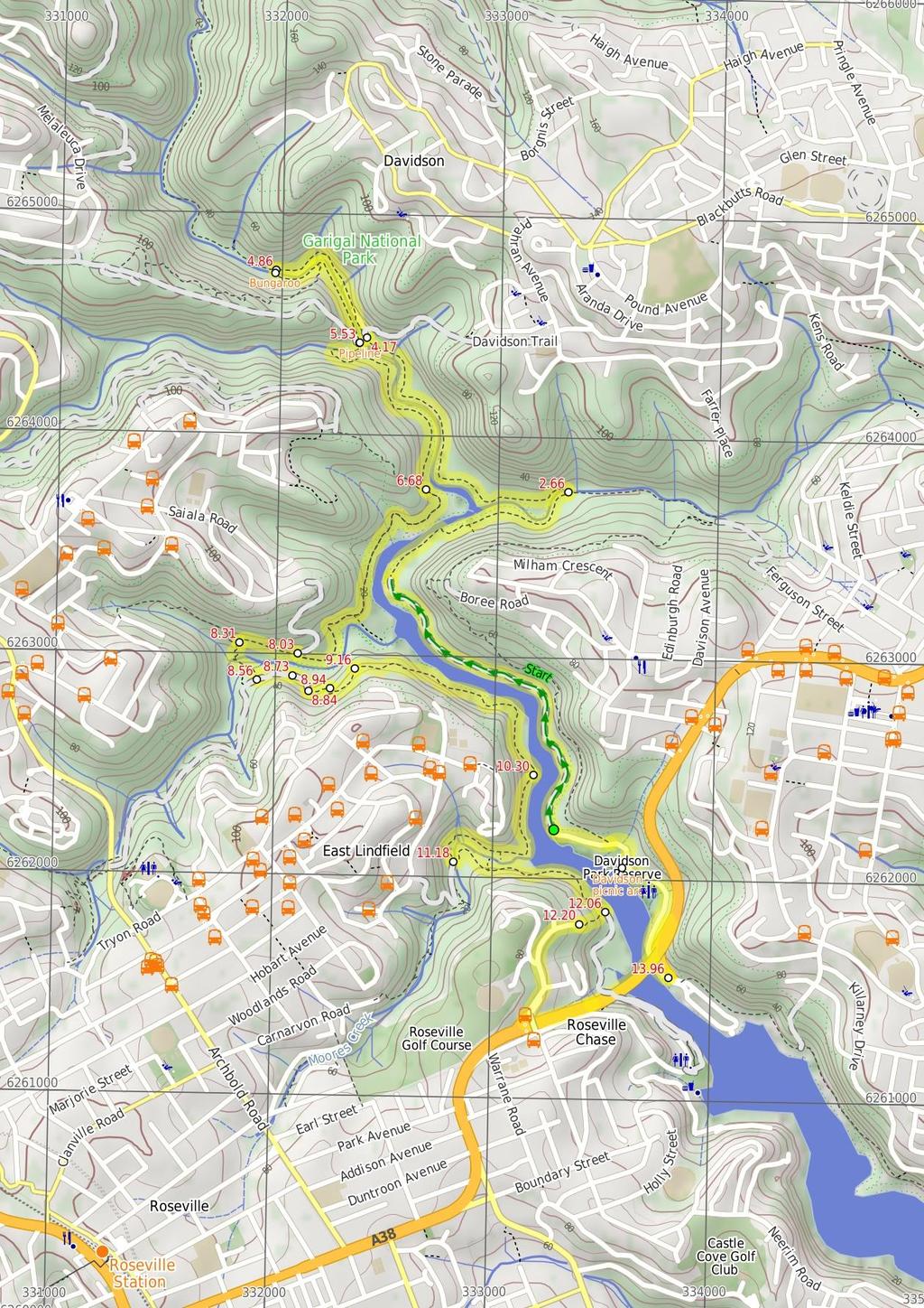
1 Middle Harbour Creek Loop 5 hrs 45 mins 15.1 km Circuit Experienced only 5 570m This walk explores the upper reaches of Middle Harbour Creek, starting and ending at the great parklands at Davidson Park, in Garigal National Park. There are plenty of nice spots along the way to rest and enjoy the views. There are several sandstone overhangs, plenty of water views and most of the walk enjoys shade from the surrounding bushland. This walk is graded so high because of a tricky creek crossing (Rocky Creek) and the faint section of track afterwards. 67m 0m Garigal National Park Maps, text & images are copyright wildwalks.com Thanks to OSM, NASA and others for data used to generate some map layers.
2 Davidson picnic area Before You walk Davidson Picnic Area is in Garigal National Park, under Roseville Bridge (access via Warringah Road, south bound lanes, or via many walking tracks in the area). The picnic area has a boat ramp, wheelchair-accessible toilets, large open grassy areas, picnic tables, free electric BBQ's, and a large rotunda. There are plenty of shady spots provided by the trees. The northern section of the picnic area has a small beach swimming area, and the southern section boasts a boat ramp. The park is open 6am to 8pm (6:30pm outside daylight savings time). Ticket machines are provided to pay the car access fee. Bushwalking is fun and a wonderful way to enjoy our natural places. Sometimes things go bad, with a bit of planning you can increase your chance of having an ejoyable and safer walk. Before setting off on your walk check 1) Weather Forecast (BOM Metropolitan District) 2) Fire Dangers (Greater Sydney Region) 3) Park Alerts (Garigal National Park) 4) Research the walk to check your party has the skills, fitness and equipment required 5) Agree to stay as a group and not leave anyone to walk solo Pipeline This pipeline is unearthed at Hunter Street, St Ives, and travels through Garigal National Park, across Middle Harbour Creek to John Oxley Drive, Sorlie. The pipe carries water under pressure From Ryde to Pymble to the reservoir at Beacon Hill. The old smallercapacity pipe can still be seen running parallel to the larger pipe. Bungaroo Governor Arthur Phillip (first governor of NSW) described this section of the river as where "the flowing of the tide ceased". Phillip and his party of nine camped here in 1788 whilst looking for land suitable for farming. John White (Surgeon General) described the the area as "the most desert, wild and solitary seclusion that the imagination can form any idea of". Over the past 200 years the river has changed, but somewhere not far upstream of the stepping stone is Bungaroo. More info. Think before you TREK The 'Think before you TREK' program developed by NSW Police & NPWS promotes the benefits of planning ahead for your bushwalking trip by using an easy to remember acronym: adequate supplies of food, water, navigation and first T Take aid equipment. your planned route and tell friends and family when R Register you expect to return. beacon (PLB's) should be carried on walks with E Emergency significant gaps in mobile coverage (check terrain profile). to your planned route and follow the map and walking K Keep trails. Topo Maps The maps provided on wildwalks are helpful, but there are times where you may need maps covering a broader area. Maps that cover this walk include; 1: Map Series:91304S HORNSBY, 91303N PARRAMATTA RIVER 1: Map Series:9130 SYDNEY Grade This walk has been graded using the AS The overall grade of the walk is dertermined by the highest classification along the whole track. 5 Grade 5/6 Experienced only Length 15.1 km Circuit Time 5 hrs 45 mins Quality of track Rough unclear track (5/6) Signs Directional signs along the way (3/6) Experience Required Some bushwalking experience recommended (3/6) Weather Weather generally has little impact on safety (1/6) Infrastructure Limited facilities, not all cliffs are fenced (3/6) * This walk passes through very remote areas and sections have no visible track. At least one person in your group should have training and experience in off track walking and navigation. Even with these notes and a GPS these extra skills and equipment are required.
3 Are you ready to have fun? Please ensure you and your group are well prepared and equipped for all possible hazards and delays. Check park closures, weather information and Fire Danger Rating before setting out. Optional side trips and alternate routes noted are not included in this walks overall grade, length or time estimate. Please allow extra time for resting and exploring areas of interest. The authors, staff and owners of wildwalks take care in preparing this information but will not accept responsibility for any inconvenience, loss or injury you may experience. Please take care, have fun - Happy Walking. Experainced walkers only: This walk passes through very remote areas and sections have no visible track. At least one person in your group should have training and experience in off track walking and navigation. Even with these notes and a GPS these extra skills and equipment are required. Getting there You can get to Int of the Lyrebird Track and end of Davidson Park driveway (gps: , ) by car or bus. Car: A park entry fee is required for driving into the park. This is a circuit, so you will finish back at the start. Find up to date and more information inlcuding; travel directions, weather, park closures and walker feedback at 0 Davidson picnic area Davidson Picnic Area is in Garigal National Park, under Roseville Bridge (access via Warringah Road, south bound lanes, or via many walking tracks in the area). The picnic area has a boat ramp, wheelchair-accessible toilets, large open grassy areas, picnic tables, free electric BBQ's, and a large rotunda. There are plenty of shady spots provided by the trees. The northern section of the picnic area has a small beach swimming area, and the southern section boasts a boat ramp. The park is open 6am to 8pm (6:30pm outside daylight savings time). Ticket machines are provided to pay the car access fee. 0 Int of the Lyrebird Track and end of Davidson Park (2.7 km 48 mins) From the gate at the north-western corner of Davidson Park, this walk follows the 'Lyrebird Track' sign through the metal gate and along the service trail, heading through the bush and following Middle Harbour Creek for a while before the track narrows to a bush track at a long grassy clearing. Continue straight: From the clearing at the end of the management trail, this walk continues along the bush track, keeping Middle Harbour Creek on the left as it meanders along the water's edge for a while. The track climbs up the side of the hill, then flattens out and continues through the bush, steadily winding down to the edge of Carroll Creek, which it follows for a while before the track comes down to the signposted intersection of the 'Carroll Creek Track' at the stepping stones Int of Lyrebird and Carroll Creek tracks (1.5 km 28 mins) Veer left: From the intersection, this walk crosses Carroll Creek at the stepping stones and continues along the bush track, passing the "Governor Phillip Walk" sign as the track bends to the left. This walk winds through the bush alongside Carrol Creek before steadily climbing up the rocky hill to the right for a little while. The track then drops back down to the edge of Middle Harbour Creek, which it follows as the walk undulates along the rocky bush track for a while, before crossing under a large pipe bridge to the end of an asphalt service trail Pipeline This pipeline is unearthed at Hunter Street, St Ives, and travels through Garigal National Park, across Middle Harbour Creek to John Oxley Drive, Sorlie. The pipe carries water under pressure From Ryde to Pymble to the reservoir at Beacon Hill. The old smaller-capacity pipe can still be seen running parallel to the larger pipe Int of Davidson and Governor Phillip tracks (700 m 1) Veer left: From the intersection, this walk follows the 'Bungaroo Track (450m)' sign, keeping Middle Harbour Creek to the left. The bush track makes its way upstream following the main creek, but crossing a few small gullies along the way. The track then comes an intersection with a signpost 'Bungaroo Track' and stepping stones across the creek, clearly visable on the left Bungaroo Governor Arthur Phillip (first governor of NSW) described this section of the river as where "the flowing of the tide ceased". Phillip and his party of nine camped here in 1788 whilst looking for land suitable for farming. John White (Surgeon General) described the the area as "the most desert, wild and solitary seclusion that the imagination can form any idea of". Over the past 200 years the river has changed, but somewhere not far upstream of the stepping stone is Bungaroo. More info Int of Gov. Phillip and Bungaroo tracks (660 m 12 mins) Turn left: From the intersection, the walk follows the 'Bungaroo Track' sign down the hill and across the creek at the large steppingstones (not safe to cross if steppingstones covered in water). This walk continues along the bush track on the other side, as it bends around to the left and continues through the thick bush and around some boulders, keeping Middle Harbour Creek a short distance through the bush to the left, until it comes to the intersection with a bush track heading up some wooden steps on the right. Continue straight: From the intersection, this walk follows the bush track, with the ground sloping up to the right, through the bush to a grassy clearing at the waters edge. From here, it continues along the track, winding back through the thick bush, keeping the creek on the left as it winds along to the intersection of the Pipeline Track, at the end of the pipe bridge Int of Pipeline and Middle Harbour Creek tracks (1.2 km 25 mins) Continue straight: From the end of the management trail, this walk heads down towards the creek and turns right, continuing under the large pipeline bridge. The track heads up and around the end of the smaller pipeline, coming to a less distinct track. The walk follows a very faint track, winding around for a little while until coming down to the edge of Rocky Creek, where there is a wire spanning the water. This walk crosses Rocky Creek and continues up through the bush, climbing steeply for a short distance before flattening out. Soon, the junction of Rocky Creek with Middle Harbour Creek comes into view, and the track bends to the right to follow Middle Harbour Creek. The rocky track undulates along the side of the hill for a long while, until coming to the intersection with a bush track (up the steep rocky hill on the right) Koola and Gordon Creek tracks Intersection (1.4 km 29 mins) Continue straight: From the intersection, this walk follows the rocky bush track, keeping Middle Harbour Creek on the left. The track undulates along the side of the hill for a while, then drops down to the wide creek. The walk passes through a mangrove clearing and crosses a smaller creek, continuing along the other side. The track then climbs steeply up a rock outcrop and continues along the side of the hill for a while, before heading over the hill and along the narrow bush track, with ground sloping up to the right and running parallel with Gordon Creek (on the left). The track heads through the dense forest, then climbs a set of wooden steps, coming to the end of a management trail at a pipe bridge Gordon Creek Pipe Bridge (bottom of Barrie Street (280 m ) Turn left: From the intersection, this walk follows the bush track, with the pipe bridge and valley on the left. The track heads through the bush for a short while before climbing steadily up the hill, then flattening out again for a while, coming to the signposted intersection with the 'Gordon Creek Track' Int of Gordon Creek Crossing and Barrie Street tra (250 m ) Turn left: From the intersection, this walk follows the 'Two Creeks Track' arrow down the wooden steps. The walk continues along the bush track as it winds down the hill, dropping down behind a rock platform and continuing down the steps. At the bottom, the track crosses Gordon Creek at the large stepping stones and continues up the short set of steps to a bush track, which it follows for a short distance before climbing a long set of wooden steps to the signposted intersection with the 'Two Creeks Track' Int of Gordon Creek Crossing track and servicetrai (170 m 4 mins) Turn left: From the intersection, this walk follows the service trail (with the ground sloping up to the right), heading through the bush to the large water pipeline that crosses Gordon Creek a short while later Gordon Creek Pipebridge (110 m 3 mins) Continue straight: From the pipe bridge, this walk follows the service trail (with the ground sloping up to the right) as it heads through the bush for a short while before it comes to a clearing at the end of the trail, at some rock steps End of Gordon Creek service trail (100 m 2 mins) Veer left: From the end of the service trail, this walk follows the bush track, climbing up the rock steps to the top where it flattens out a little. The track continues up the long gentle hill for a little while, with the valley down to the left, until coming to the intersection with the defined bush track on the right Western end of Two Creeks detour (220 m ) Turn sharp right: From the intersection, this walk follows the bush track, climbing up the steep rock steps until the track flattens out and turns left. The walk continues along the side of the hill for a short while, before dropping down some steps cut into a rock outcrop. The track then continues through the bush for a while before coming down to the intersection of the Two Creeks bush track Eastern end of Two Creeks detour (1.1 km 25 mins) Turn right: From the intersection, this walk follows the bush track (with the ground sloping up to the right) as it heads through the trees and along the side of the hill. The track passes a 'Garigal National Park' sign while bending around to follow the Middle Harbour Creek. The walk continues through the bush for a while until it crosses a long wooden walkway to the intersection of the 'to Wellington Road' bush track, at the wooden steps on the right Int of Two Creeks and Wellington Road tracks (880 m 18 mins) Continue straight: From the intersection, this walk follows the bush track (keeping Middle Harbour Creek on the left) as it heads through the ferns and around some mangroves (down to the left). After a little while,the track bends to the right and following Moores Creek, heading along the side of the hill and under a shallow rock overhang and passing an old stone chair. The walk crosses a short wooden bridge and follows the wide bush track as it continues along the side of the hill, until it comes to the signposted intersection with the 'Carlyle Road' bush track at the next wooden bridge, near another stone chair Int of Two Creeks and Carlyle Road tracks (880 m 20 mins) Turn left: From the intersection, this walk heads across the

4 wooden bridge and follows the track through the bush and along the side of the hill. After a while, the track bends around to the right and follows the wide Middle Harbour Creek, with Davidson Park across on the other side. The track continues along the side of the hill above Middle Harbour Creek for a while, before coming to the signposted intersection of the 'Ormonde Road 200m' track, uphill on the right Int of Two Creeks and Ormonde Road tracks (150 m ) Turn sharp right: From the intersection, the walk follows the 'Ormonde Road 200m' arrow up the steep rocky hill. The walk flattens out and continues to the end of Ormonde Rd End of Ormonde Road Track (1.8 km 39 mins) Veer left: From the intersection, the walk follows Ormonde Rd up the hill (passing Chase Ave, Cardigan Rd and The Kingsway), passing the off-ramp from Warringah Rd, then turning right at the Warringah Rd onramp (just before the bridge over Warringah Rd). The walk follows the grassy strip at the left hand edge of the on-ramp, as it loops around under the bridge. The walk continues down the hill following the very narrow verge on the left-hand side of Warringah Rd until reaching an intersection with a concrete footpath (which goes down the hill to the left, closed at the time of writing), just before the Roseville Bridge. Continue straight: From the intersection, this walk follows the footpath on the left-hand side of Warringah Rd and crosses the long Roseville Bridge. The walk continues up the hill before turning sharply to the left and following the off-ramp road down the hill. After crossing under the Roseville Bridge the walk arrives at the intersection with the Davidson Park driveway Int of Davidson Park Driveway and Warringah Road o (1.1 km 20 mins) Turn right: From the intersection, this walk follows the Davidson Park driveway, crossing under Roseville Bridge with Middle Harbour Creek on the left. The walk passes a small car park and bends to the right, winding around the large picnic areas (on the left), passing a building with some toilets (also on the left), and continuing along for a little while before coming to the signposted intersection of the Rotary Rotunda footpath. Continue straight: From the intersection, this walk follows the road, keeping the park and Middle Harbour on the left. After a little while, this walk comes to the signposted intersection at the bottom of the 'Casuarina Stairway', uphill on the right. Continue straight: From the intersection at the bottom of the 'Casuarina Stairway', this walk follows the driveway, keeping the park and Middle Harbour Creek on the left. The walk heads along for little while before coming to the end of the driveway, at the signposted start of the 'Lyre Bird Track 4km'.
5
6 Summary navigation sheet for the Middle Harbour Creek Loop km From Up/Dwn Length Initial directions (Use full tracknotes and maps for more detail) Start Int of the Lyrebird Track and end of Davidson Park driveway , (GR Parramatta River, ) km 48 mins From the gate at the north-western corner of Davidson Park, this walk follows the 'Lyrebird Track' sign through the metal gate and along the service trail, heading through the bush and following Middle Harbour Creek Int of Lyrebird and Carroll Creek tracks , (GR Parramatta River, ) Int of Davidson and Governor Phillip tracks , (GR Hornsby, ) Int of Gov. Phillip and Bungaroo tracks , (GR Hornsby, ) Int of Pipeline and Middle Harbour Creek tracks , (GR Hornsby, ) Koola and Gordon Creek tracks Intersection , (GR Parramatta River, ) Gordon Creek Pipe Bridge (bottom of Barrie Street Track) , (GR Parramatta River, ) km 28 mins 700 m m 12 mins 1.2 km 25 mins 1.4 km 29 mins 280 m Veer left: From the intersection, this walk crosses Carroll Creek at the stepping stones and continues along the bush track, passing the "Governor Phillip Walk" sign as the track bends to the left. Veer left: From the intersection, this walk follows the 'Bungaroo Track (450m)' sign, keeping Middle Harbour Creek to the left. Turn left: From the intersection, the walk follows the 'Bungaroo Track' sign down the hill and across the creek at the large steppingstones (not safe to cross if steppingstones covered in water). Continue straight: From the end of the management trail, this walk heads down towards the creek and turns right, continuing under the large pipeline bridge. Continue straight: From the intersection, this walk follows the rocky bush track, keeping Middle Harbour Creek on the left. Turn left: From the intersection, this walk follows the bush track, with the pipe bridge and valley on the left Int of Gordon Creek Crossing and Barrie Street tracks , (GR Parramatta River, ) m Turn left: From the intersection, this walk follows the 'Two Creeks Track' arrow down the wooden steps Int of Gordon Creek Crossing track and servicetrail , (GR Parramatta River, ) Gordon Creek Pipebridge , (GR Parramatta River, ) End of Gordon Creek service trail , (GR Parramatta River, ) Western end of Two Creeks detour , (GR Parramatta River, ) Eastern end of Two Creeks detour , (GR Parramatta River, ) Int of Two Creeks and Wellington Road tracks , (GR Parramatta River, ) Int of Two Creeks and Carlyle Road tracks , (GR Parramatta River, ) Int of Two Creeks and Ormonde Road tracks , (GR Parramatta River, ) End of Ormonde Road Track , (GR Parramatta River, ) m 4 mins 110 m 3 mins 100 m 2 mins 220 m 1.1 km 25 mins 880 m 18 mins 880 m 20 mins 150 m 1.8 km 39 mins Turn left: From the intersection, this walk follows the service trail (with the ground sloping up to the right), heading through the bush to the large water pipeline that crosses Gordon Creek a short while later. Continue straight: From the pipe bridge, this walk follows the service trail (with the ground sloping up to the right) as it heads through the bush for a short while before it comes to a clearing at the end of the t... Veer left: From the end of the service trail, this walk follows the bush track, climbing up the rock steps to the top where it flattens out a little. Turn sharp right: From the intersection, this walk follows the bush track, climbing up the steep rock steps until the track flattens out and turns left. Turn right: From the intersection, this walk follows the bush track (with the ground sloping up to the right) as it heads through the trees and along the side of the hill. Continue straight: From the intersection, this walk follows the bush track (keeping Middle Harbour Creek on the left) as it heads through the ferns and around some mangroves (down to the left). Turn left: From the intersection, this walk heads across the wooden bridge and follows the track through the bush and along the side of the hill. Turn sharp right: From the intersection, the walk follows the 'Ormonde Road 200m' arrow up the steep rocky hill. Veer left: From the intersection, the walk follows Ormonde Rd up the hill (passing Chase Ave, Cardigan Rd and The Kingsway), passing the off-ramp from Warringah Rd, then turning right at the Warringah Rd on-ramp (ju
7 Summary navigation sheet for the Middle Harbour Creek Loop km From Int of Davidson Park Driveway and Warringah Road on-ramp , (GR Parramatta River, ) Powered by TCPDF ( Up/Dwn Length Initial directions (Use full tracknotes and maps for more detail) km 20 mins Turn right: From the intersection, this walk follows the Davidson Park driveway, crossing under Roseville Bridge with Middle Harbour Creek on the left.
Little Digger Track to Davidson Reserve and Lyrebird Circuit
 Little Digger Track to Davidson Reserve and Lyrebird Circuit 4 hrs 3 mins 11.5 km One way Hard track 4 47m Exploring both the eastern and western sides of Middle Harbour Creek, this walk follows the Little
Currie Rd to Davidson Park
 Currie Rd to Davidson Park 3 hrs 7.2 km One way Moderate track 28m Starting at Currie Rd in Forestville, this walk follows Middle Harbour to Davidson Park, under Roseville Bridge. There are two optional
Little Digger Track. 68m. 1 Hr 2.2 km One way. Moderate track 93m. Moores Creek Reserve
 Little Digger Track Hr 2.2 km One way Moderate track 93m This walk follows Moores Creek through several reserves in east Roseville and East Lindfield. The track is named after Australia's 7th Prime Minster,
Waterfall to Heathcote
 Waterfall to Heathcote 5 hrs Hard track 10.8 km One way 4 467m This walk explores the heart of Heathcote National Park, and is easily accessed with a train station at either end. Although relatively close
Hunters Hill to Epping Road
 Hunters Hill to Epping Road 2 hrs 30 mins 5.5 km One way Moderate track 154m An enjoyable walk through lower sections of the Lane Cove National Park, this walk features plenty of mangroves next to the
Morgans Creek to Padstow
 Morgans Creek to Padstow 2 hrs 45 mins 8 km One way Moderate track 3 144m This pleasant walk starts from the Morgans Creek park, at Henry Lawsons Drive, and follows the Georges River past the Boomerang
Echo Point to Leura Forest via Three Sisters and Giant Stairs loop
 Echo Point to Leura Forest via Three Sisters and Giant Stairs loop 3 hrs 3.8 km Circuit Hard track 512m This walk starts from the popular Echo Point, in Katoomba, and winds down to the base of the Three
Wentworth Falls Conservation Hut Loop
 Wentworth Falls Conservation Hut Loop 3 hrs Hard track 6.7 km Circuit 4 341m This scenic walk from Wentworth Falls Station, winds along the Nature Trail to Conservation Hut, then drops into the magnificent
Epping to Pennant Hills Station (via Lane Cove River)
") Epping to Pennant Hills Station (via Lane Cove River) 3 hrs 5 mins 8.4 km One way Hard track 249m This walk, from Epping to Pennant Hills Station, is a great way to see the upper Lane Cove River Valley.
Epping to Pennant Hills Station (via Lane Cove River) 3 hrs 5 mins 8.4 km One way Hard track 249m This walk, from Epping to Pennant Hills Station, is a great way to see the upper Lane Cove River Valley.
Popes Glen, Pulpit Rock, Govetts Leap and Braeside Walk
 Popes Glen, Pulpit Rock, Govetts Leap and Braeside Walk 8 hrs Hard track 13.6 km Circuit 4 1068m This large circuit walk, from Popes Glen to Pulpit Rock, Govetts leap and along the Braeside Track, passes
Carrington Park to Leura Forest and pass loop
 Carrington Park to Leura Forest and pass loop 3 hrs Hard track 4.8 km Circuit 4 674m This walk is a fantastic way to see Leura Forest. The walk descends from Carrington Park, visiting Leura Forest and
Rail to River Walk. 3 hrs. Hard track 7.5 km Circuit. 222m
 Rail to River Walk 3 hrs Hard track 7.5 km Circuit 4 222m This walk is a great one from Chatswood Station to the Lane Cove River National Park. The walk descends through the vegetated bushland which fills
Govetts Leap Loop. 1065m. 909m Blue Mountains National Park. 4 hrs 30 mins 8.7 km Circuit. Hard track 380m
 Govetts Leap Loop 4 hrs 30 mins 8.7 km Circuit Hard track 380m This walk, from Blackheath Train Station, is a fantastic way to see some of the iconic areas of the Blue Mountains in the Blackheath area.
Hornsby Blue Gum Walk
 Hornsby Blue Gum Walk 3 hrs Hard track 6.7 km Circuit 4 374m This delightful loop is one of the prettiest and most popular walks in the Hornsby area. Going from an environment of ferns and clear bushland
Heathcote to Engadine via Audley
 Heathcote to Engadine via Audley 6 hrs 3 mins 5 km One way Hard track 4 635m Covering a large section of central Royal National Park, this walk goes through the heath and scrub along a well managed and
Epping to Eastwood Station (via Lane Cove River)
") Epping to Eastwood Station (via Lane Cove River) hrs 45 mins 10.2 km One way Moderate track 189m Epping to Eastwood, via Lane Cove River, is the longer route through the bush between the stations. This
Epping to Eastwood Station (via Lane Cove River) hrs 45 mins 10.2 km One way Moderate track 189m Epping to Eastwood, via Lane Cove River, is the longer route through the bush between the stations. This
Sphinx, Warrimoo and Bobbin Head tracks
 Sphinx, Warrimoo and Bobbin Head tracks 4 hrs 9.6 km Circuit Moderate track 499m This great walk starts at the Sphinx Memorial and loops around via Cowan Creek, exploring diverse environments as it changes
Sid Pulsford Walk. 175m. 33m. 1 hr 45 mins 4.1 km One way. Hard track 118m. Gosford LGA
 Sid Pulsford Walk 1 hr 5 mins.1 km One way Hard track 118m Sid Pulsford Walk explores the ridge top of Kincumber Mountain, from Honeman's Rock to Green Point. The walk mostly follows wide management trails.
Wattamolla to Big Marley Beach
 Wattamolla to Big Marley Beach 4 hrs 10.4 km Circuit Moderate track 4m This walk is an excellent loop which takes in both the coast and the heathy inland of Royal National Park. Nearly the whole walk has
Campbell Drive to Snapper Point
 Campbell Drive to Snapper Point 1 hr 45 mins 4.2 km One way Experienced only 135m This walk follows the Coast Track to Frazer Beach, along the Geebung and (overgrown) Grass Tree Tracks. From the northern
Katoomba Falls Circuit
 Katoomba Falls Circuit hr 5 mins.5 km Circuit Hard track 59m For those looking for a walk involving more than simple boardwalk, this trail winding through the temperate rain forest could be just the thing.
Callicoma Loop. 174m. 98m. 2 hrs. Hard track 5.1 km Circuit. 153m
 Callicoma Loop 2 hrs Hard track 5.1 km Circuit 153m This great circuit walk passes through some really nice forest around the fringe of Cherrybrook. Highlights of the walk include some beautiful rock overhangs
Rail to River and Stringybark Creek Reserve Walk
 Rail to River and Stringybark Creek Reserve Walk 4 hrs Hard track 11.2 km Circuit 4 302m This walk begins in the busy city of Chatswood and soon enters the nearby bushland around the Lane Cove River. The
De Burgs Bridge to Thornleigh station
 De Burgs Bridge to Thornleigh station 3 hrs 45 mins 9.7 km One way Hard track 4 363m This walk follows a section of the Great North Walk, starting from De Burghs bridge. The walk winds north west, through
Mackerel Beach, West Head Loop
 Mackerel Beach, West Head Loop 5 hrs 8.6 km Circuit Hard track 422m The Mackerel Beach, West Head Loop is a walk which explores a large part of the West Head. The journey starts and finishes with a ferry
Dead Horse Gap Loop track
 Dead Horse Gap Loop track 4 hrs 30 mins Hard track 9.8 km Circuit 144m 4 This walk starts with a ride up the Kosciuszko Express Chairlift. There is an opportunity to eat at Australia's highest restaurant,
Wallarah Coastal Walk
 Wallarah Coastal Walk 3 hrs 8.3 km Return Hard track 247m This walk starts at Caves Beach and travels south along the coastline, until reaching the Pinney s Headland Lookout. There are many opportunities
The Basin Track and Mackerel Track
 The Basin Track and Mackerel Track 3 hrs 5.9 km Circuit Hard track 226m This walk is a great way to see some popular areas in Ku-ring-gai Chase National Park. The walk from West Head Rd travels to The
The Foreshore Walk. 24m. 1m Lake Macquarie LGA. 1 hr 15 mins 2.9 km One way. Hard track 81m
 The Foreshore Walk 1 hr 15 mins 2.9 km One way Hard track 81m This walk traverses the coastline of the Green Point reserve. By following a variety of tracks and occasionally traveling inland through eucalyptus
Balmoral Beach to The Spit
 Balmoral Beach to The Spit 2 hrs 30 mins.3 km One way Hard track 85m This walks follows the coast from Balmoral to the Spit and across Spit Bridge. There are some alternate tracks to consider at high-tides,
Scenic World to Echo Point
 Scenic World to Echo Point 1 hr 15 mins 2.1 km One way Moderate track 192m This is one of the most popular tourist walks in the Katoomba area. The walk follows the cliffs along a well maintained and signposted
Mackerel Beach and Resolute Loop
 Mackerel Beach and Resolute Loop 3 hrs 5.4 km Circuit Hard track 384m This walk is another great walk in Ku-ring-gai Chase National Park, accessed by ferry. From the Mackerel Beach wharf, this walk uses
Teralba to Charlestown Park track head
 Teralba to Charlestown Park track head 4 hrs 30 mins 13.3 km One way Moderate track 3 220m This section of the Great North Walk starts from the Teralba train station and winds down and around the edge
Berowra to Mt Kuring-gai
 Berowra to Mt Kuring-gai 4 hrs 30 mins 9.4 km One way Hard track 4 551m From the ridges above Cowan Creek, this walk takes in some great lookouts (especially around Mt Kuringgai) as well as enjoying an
Upper Rumbalara circuit
 Upper Rumbalara circuit 1 hr 30 mins 3.3 km Circuit Hard track 176m A great circuit walk, covering most of the walking tracks and sights in the upper section of the Rumbalara Reserve. There is some really
Wentworth Falls Station Loop (Undercliff Walk)
") Wentworth Falls Station Loop (Undercliff Walk) 4 hrs 3 mins Hard track 8.9 km Circuit 658m 4 This walk passes some stunning waterfalls and views into the Jamison Valley, following the cliff edges around
Wentworth Falls Station Loop (Undercliff Walk) 4 hrs 3 mins Hard track 8.9 km Circuit 658m 4 This walk passes some stunning waterfalls and views into the Jamison Valley, following the cliff edges around
Under and Over Cliff Walk
 Under and Over Cliff Walk 4 hrs 9.4 km Circuit Moderate track 576m This walk from Wentworth Falls Station is a fantastic way to see a large majority of the Wentworth Falls cliffline. The track winds under
National Pass from Wentworth Falls to Conservation Hut
 National Pass from Wentworth Falls to Conservation Hut 3 hrs Hard track 3.6 km One way 739m Starting at Wentworth Falls picnic area, this scenic and historic walk explores many waterfalls, lookouts and
Epping to Gordon Station
 Epping to Gordon Station 4 hrs 15 mins 11.7 km One way Hard track 4 365m This walk, from Epping Station to Gordon Station, passes below the homes which sit on the hills high above the Lane Cove River.
Woolwich Wharf to Boronia Park
 Woolwich Wharf to Boronia Park 2 hrs 5.8 km One way Moderate track 175m Going through the streets of Hunters Hill, this walk is on the first segment of the Great North Walk. The majority of the walk is
Spit Bridge to Middle Head Forts
 Spit Bridge to Middle Head Forts 2 hrs 30 mins 6.3 km One way Hard track 4 181m This scenic walk takes you from the Spit Bridge, along the coast to explore the Middle Head Forts. There are a few alternate
Roseville to Macquarie Park
 Roseville to Macquarie Park 3 hrs 3 mins 8.8 km One way Hard track 4 29m This walk starts at Roseville station and explores the streets and alleyways of Roseville before joining the main spine of the Great
Green Point Circuit Walk
 Green Point Circuit Walk 3 hrs 7.7 km Circuit Hard track 269m This walk visits all of the popular locations in Green Point Reserve, as well as some of the lesser-visited areas inland. Taking in Sea Eagle
De Burghs Bridge to Fullers Bridge
 De Burghs Bridge to Fullers Bridge 2 hrs 3 mins Hard track 6 km One way 2m 4 Following the Lane Cove River, this walk mostly follows a section of the Great North Walk and is well maintained and signposted.
Blackheath Station to Junction Rock Loop (via Grand Canyon and Popes
 Blackheath Station to Junction Rock Loop (via Grand Canyon and Popes 8 hrs 30 mins 18.2 km Circuit Hard track 4 1254m This circuit starts in Blackheath and heads down into the Grand Canyon and Rodriguez
Bouddi Coastal Walk. 5 hrs. Hard track 8.1 km One way. 364m
 Bouddi Coastal Walk 5 hrs Hard track 8.1 km One way 4 364m This is one of the longer walks in the Bouddi National Park and it is rich in scenery. The walk follows the coastline with many side trips to
Echo Point to Leura Forest Circuit
 Echo Point to Leura Forest Circuit 3 hrs 4.8 km Circuit Hard track 588m Forming a circuit around the cliffs and then the valley floor, this is a walk more then capable of convincing a walker of the beauty
Patonga to Woy Woy. 5 hrs 45 mins 15.5 km One way. Hard track. 497m
 Patonga to Woy Woy 5 hrs 45 mins 15.5 km One way Hard track 4 497m This walk explores a variety of environments from the shore line and coastal cliffs near Patonga, to the dry, rocky and open ridge line.
Dubbo Gully and Ten Mile Hollow Circuit (via Clares Bridge)
") Dubbo Gully and Ten Mile Hollow Circuit (via Clares Bridge) 2 Days Hard track 24.3 km Circuit 4 1117m This two day (or ten hour) walk follows several historic roads, now closed to traffic. Starting with
Dubbo Gully and Ten Mile Hollow Circuit (via Clares Bridge) 2 Days Hard track 24.3 km Circuit 4 1117m This two day (or ten hour) walk follows several historic roads, now closed to traffic. Starting with
Federal Pass Walking Track
 Federal Pass Walking Track 5 hrs Hard track 8 km One way 4 989m This classic trail follows along the base of the cliffs from Leura to the Golden Stairs, passing many of the more popular sights of the Katoomba
Thornleigh to Hornsby
 Thornleigh to Hornsby 4 hrs Hard track 10.2 km One way 4 526m Starting at Thornleigh station you walk through suburban streets for a short while before diving into the bush at the southern end of Berowra
Glenbrook and Euroka Circuit
 Glenbrook and Euroka Circuit 2 Days 16.6 km Circuit Experienced only 790m This two day circuit, returning to Glenbrook Station, is a scenic walk which passes many of the tourist attractions within the
Wentworth Falls Station Loop
 Wentworth Falls Station Loop 5 hrs 3 mins 9.5 km Circuit Hard track 4 13m The Wentworth Falls Station Loop takes in most of the upper tracks around Wentworth Falls. There are many scenic views near the
Taronga Wharf to Chowder Bay
 Taronga Wharf to Chowder Bay 2 hrs 4.4 km One way Moderate track 246m Starting at Taronga Wharf, this walk passes many icons of Sydney, including Taronga Zoo, HMAS Sydney Mast, Chowder Bay. The walk also
Sphinx to Mt Kuring-gai
 Sphinx to Mt Kuring-gai 4 hrs 45 mins 1.7 km One way Hard track 673m This walk starts at the Sphinx War Memorial and follows some well maintained and popular walking tracks down to Cowan Creek. Enjoy the
Gordon to Chatswood Station
 Gordon to Chatswood Station 4 hrs 30 mins 12.2 km One way Hard track 4 381m This walk is a great way to get into the bush without being far from civilisation. The walk wanders through untouched valleys
Lane Cove Tourist Park River Circuit
 Lane Cove Tourist Park River Circuit 5 hrs 12 km Circuit Hard track 383m This walk follows a large section of Lane Cove River. The walk follows the Riverside Walking track up the Lane Cove River to De
Wentworth Falls Loop. 893m. 665m. 6 hrs 10.2 km Circuit. Hard track 1093m. Blue Mountains National Park
 Wentworth Falls Loop 6 hrs 1.2 km Circuit Hard track 193m This is a great walk, both in size and spectacular views. The walk makes its way from Wentworth Falls train station and drops off the plateau,
Hermitage Foreshore Track
 Hermitage Foreshore Track 1 Hr 2.2 km One way Moderate track 123m The Hermitage Foreshore Walk is a wonderful way to explore Sydney Harbour from the perspective of South Head. This walk starts from Nielsen
Rumbalara Explorer. 158m. 5m Rumbalara Reserve. 2 hrs 45 mins 6.1 km Circuit. Hard track 326m
 Rumbalara Explorer 2 hrs 5 mins 6.1 km Circuit Hard track 326m Pretty well the grand tour of the Rumbalara Reserve, this walk takes in much of the great scenery the reserve has to offer. The walk covers
Bobbin Head Loop. 166m. 0m Ku-ring-gai Chase National Park. 5 hrs 12.9 km Circuit. Hard track 619m
 Bobbin Head Loop 5 hrs 12.9 km Circuit Hard track 619m This great circuit walk enjoys a variety of landscapes in Ku-ring-gai Chase National Park. The walk starts at the historic Sphinx war memorial and
Faulconbridge to Blaxland
 Faulconbridge to Blaxland 2 Days Experienced only 15.2 km One way 5 693m This two-day walk, or very solid one-day walk, takes you from station to station, through lush, scenic forest in the lower Blue
North Ryde Fairyland circuit
 North Ryde Fairyland circuit 2 hrs 30 mins Hard track 6.9 km Circuit 193m 4 Starting at North Ryde train station this walk explores a stretch of the Lane Cove River, visiting the historic Fairlylands Pleasure
Spit Bridge to Manly (Manly Scenic Walkway)
") Spit Bridge to Manly (Manly Scenic Walkway) 3 hrs 45 mins 9.1 km One way Moderate track 349m The Spit to Manly walk is a classic bushwalk on Sydney's Northern Beaches. The walk follows a well-maintained
Spit Bridge to Manly (Manly Scenic Walkway) 3 hrs 45 mins 9.1 km One way Moderate track 349m The Spit to Manly walk is a classic bushwalk on Sydney's Northern Beaches. The walk follows a well-maintained
Gosford to Lisarow. 202m
 Gosford to Lisarow 4 hrs 3 mins Hard track 11.3 km One way 4 479m This walk is a great way to explore the ridge-top bushland between Gosford and Lisarow. Passing through Rumbalara and Katandra Reserves,
Scenic world to Three Sisters Loop via Furber Steps
 Scenic world to Three Sisters Loop via Furber Steps 5 hrs 5.8 km Circuit Hard track 722m This walk starts from the popular Scenic World, in Katoomba, and winds down the Furber steps into the Jamison Valley,
Charlestown Park trackhead to Newcastle station
 Charlestown Park trackhead to Newcastle station 5 hrs 30 mins 12.1 km One way Hard track 4 287m This section of the Great North Walk starts from the Charleston Park track head and winds through the streets
The Coast Track. 2 Days. Hard track 27.4 km One way. 1351m
 The Coast Track 2 Days Hard track 27.4 km One way 4 1351m Heading south, this walk covers the coastline of the Royal National Park and can truly only be described as amazing. With breathtaking coastal
Chatswood to Epping Station
 Chatswood to Epping Station 6 hrs Hard track 16.3 km One way 4 533m This walk, from Chatswood to Epping, is a long but enjoyable walk along the Lane Cove valley. The walk mostly follows the Lane Cove River
Manly to Seaforth Oval
 Manly to Seaforth Oval 5 hrs 45 mins 13.7 km One way Moderate track 3 624m This walk follows the Manly to Spit Scenic Walkway, then continues past The Spit Bridge to Seaforth Oval. The walk provides magnificent
Cape Banks Circuit. 50m. 2m Botany Bay National Park. 3 hrs 7.3 km Circuit. Hard track 190m
 Cape Banks Circuit 3 hrs 7.3 km Circuit Hard track 19m This Cape Banks Circuit has a lot to offer and is thoroughly recommended. The walking travels over beaches, through coastal forest and across exposed
Bouddi Ridge and Coastal Walk
 Bouddi Ridge and Coastal Walk 2 Days Hard track 27 km Circuit 4 126m This overnight walk takes in the majority of the magnificent Bouddi National Park. The walk starts from the pleasant Putty Beach camping
Narrabeen Lagoon Trail (from Middle Creek)
") Narrabeen Lagoon Trail (from Middle Creek) 2 hrs 30 mins 8.6 km Circuit Very easy 1 105m The Narrabeen Lagoon Trail is a wonderful and accessible walk on the Northern Beaches of Sydney. The trail is used
Narrabeen Lagoon Trail (from Middle Creek) 2 hrs 30 mins 8.6 km Circuit Very easy 1 105m The Narrabeen Lagoon Trail is a wonderful and accessible walk on the Northern Beaches of Sydney. The trail is used
Taronga Zoo to Spit Bridge
 Taronga Zoo to Spit Bridge 5 hrs Hard track 1.4 km One way 4 41m This is a scenic and culturally rich walk with views over Sydney Harbour and many interesting heritage buildings along the way. The start
Sydney to Thornleigh via Lane Cove Tourist Park
 Sydney to Thornleigh via Lane Cove Tourist Park 2 Days 33 km One way Hard track 4 1114m This overnight walk starts from the Obelisk in Macquarie Park, Sydney, at the official start of the Great North Walk.
Light to Light Walk 2 days
 Light to Light Walk 2 days 2 Days Hard track 3.9 km One way 4 794m Over two days, this classic walk explores the coast from Boyd Tower to the Green Cape Lighthouse in the south. Hegartys Bay Camp is over
Six Foot Track. 1212m
 Six Foot Track 3 Days 44.8 km One way Hard track 4 2066m This classic walk takes you from Katoomba to Jenolan Caves via a historic horse route. The walk travels mainly along well-maintained service tracks
ULTRA-TRAIL AUSTRALIA May 2018 COURSE DESCRIPTION AND COURSE NOTES
 ULTRA-TRAIL AUSTRALIA 100 19-20 May 2018 COURSE DESCRIPTION AND COURSE NOTES LEG 1 Scenic World (Start) to Narrow Neck (Checkpoint 1) Course Description: From the start, at the front entrance of Scenic
NEWLANDS CORNER AND ST MARTHAS
 NEWLANDS CORNER AND ST MARTHAS 10k CIRCULAR ROUTE 2½-3HRS GU4 8SE From Newlands Corner on the North Downs just outside Guildford, you can enjoy one of the most beautiful panoramas of quintessential English
Detailed maps, and portaging and camping information follow.
 Overview of Bain route. The launch site is at Davidson Lake, just before the Manitoba/Ontario border. You can do a loop if you leave a vehicle at Tulabi Lake (at the canoe route parking lot). The road
Tideswell to Castleton
 Tideswell to Castleton 1 Walk summary Length: 14 km, 8.5 miles Maps: OS Explorer OL1 The Peak District - Dark Peak Area, OS Explorer OL24 The Peak District - White Peak Area, OS Landranger 110 Sheffield
Hammer Vale and Linchmere Common
 point your feet on a new path Hammer Vale and Linchmere Common Distance: 9 km=5½ miles or 6 km=3¾ miles easy walking with one steep section Region: Hampshire, West Sussex Author: Botafuego Refreshments:
THE BECK STONE Backstone Beck on Ilkley Moor
 THE BECK STONE Backstone Beck on Ilkley Moor 1 Three different routes which take in the best of the lower slopes of Ilkley Moor, with bracken, heather, a tarn (a small mountain lake) and rushing streams.
MAPS & WALK NOTES. DAY 2: Greenwich Wharf to Woolwich Wharf
 MAPS & WALK NOTES DAY 2: Greenwich Wharf to Woolwich Wharf Total Distance: 15.5km Time: Approximately 5 hours 30 mins five Sections Walk Notes in Section Name Length Time 2:1 Greenwich Wharf to Northwood
Start / Finish. Version 2
 Start / Finish Version 2 Gosford (Start) to Woy Woy Head South down Etna Street, crossing Henry Parry Drive, then Mann St, Gosford, where Etna St becomes Racecourse Road. Follow this road all the way
Beautiful Walks from the Blue Ball Inn
 Walk No. 7 COAST AND VALLEY WALK Countisbury, Glenthorne, County Gate, Brendon, Rockford and Wilsham 10 MILES APPROX. Walking time 5 hours approx. (not including breaks)> OS Sheet 64/74 Lynton and Lynmouth.
9.5 km Circular 3 hours
 MEDIEVAL WAVERLEY Challenging Terrain A 6 mile (9.5km) undulating circular walk from Tilford village passing close to The Sands village and the historic ruins of Waverley Abbey. From the top of Crooksbury
8 Miles Circular 4 hours
 VISIT RYEDALE HELMSLEY AND RICCAL DALE 8 Miles Circular 4 hours 090616 Challenging Terrain An 8 mile (13km) circular walk from the market town of Helmsley in Ryedale. The route heads out across sheep pastures
Walk: NOC 08 Location: Cym Glyn near Brecon
 33 Walk: NOC 08 Location: Cym Glyn near Brecon Directions: Not easy to find at all. Go to Libanus, then head towards Brecon on the A470. Take minor C road single track lane first right as you come out
10 Miles Circular 5 hours
 VISIT RYEDALE PICKERING AND CAWTHORN CAMPS 10 Miles Circular 5 hours Moderate Terrain 120616 A 10 mile (16km) there and back walk from the market town of Pickering in Ryedale. The route heads north through
THE WELLDIGGERS ARMS, HESWORTH AND FITTLEWORTH TRAIL
 THE WELLDIGGERS ARMS, HESWORTH AND FITTLEWORTH TRAIL 5.5 miles Circular 3 hours 041017 Challenging Terrain A 300-year-old pub turned country-inn on the edge of the South Downs National Park, The Welldiggers
The North Pennines from near Langwathby
 3.6 Langwathby to Armathwaite Map panel?? Distance 12.7 miles (20.5 km) Terrain farm, woodland and riverside paths; some potentially muddy tracks; a few short sections of road Grade gently undulating Food
Detailed Descriptions and Maps of Woodside s Nature Trails
 Detailed Descriptions and Maps of Woodside s Nature Trails Access Mill Road Trail Park along Anderson Mill road. Signs on West Pleasant Colony and Anderson Mill road clearly point to the beginning of the
LDWA SOUTH DOWNS MARATHON 13 th MAY 2018
 AHD ahead SDW South Downs Way BL/BR bear left/bear right TL/TR turn left/turn right X cross LEG 1 - EAST DEAN to WP1 NORTON GR 470019. Open 1030 to 1300. 9.7 miles. 1.1 From village hall TL and walk to
Harbour Bridge to Taronga Zoo
 Harbour Bridge to Taronga Zoo 4 hrs 9.8 km One way Moderate track 389m On this walk, you will explore much of the foreshore linking Milsons Point Station to Taronga Zoo Ferry wharf. The walk is mostly
Danbury Words and pictures by Laurie Page of the Public Rights of Way team at Essex County Council.
 Danbury Words and pictures by Laurie Page of the Public Rights of Way team at Essex County Council. An undulating walk from Danbury village to the bluebells at the National Trust property of Blakes Wood.
HARDMOORS 26.2 WHITE HORSE HALF ROUTE DESCRIPTION - 018
 HARDMOORS 26.2 WHITE HORSE HALF ROUTE DESCRIPTION - 018 Follow Cleveland Way, keeping to the left hand path (right path is a bike trail) Ignoring any turnings to the left or right At path junction (after
Bakewell Club Site - Robin Hood's Stride
 Bakewell Club Site - Robin Hood's Stride Camping and Caravanning Route Summary A circular walk with fabulous views winding it's way through the beautiful White Peak scenery. Points of interest include
Rhossili - Tears Point - Mewslade Bay - Talgarth's Well - Rhossili - ID: 148. Walk description:
 Walk description: A glorious walk combining thrilling cliffs with beautiful wild beaches and a bird's-eye view of the Gower peninsula from Rhossili Down. The adventurous can walk out to the Worm's Head
Distance: 14 km=8½ miles or 7 km=4½ miles easy-to-moderate walking
 point your feet on a new path Normandy Distance: 14 km=8½ miles or 7 km=4½ miles easy-to-moderate walking Region: Surrey Author: Botafuego Refreshments: Pirbright, Ash date written: 20-feb-2012 date revised: