Six Foot Track. 1212m
|
|
|
- Gertrude Woods
- 5 years ago
- Views:
Transcription


1 Six Foot Track 3 Days 44.8 km One way Hard track m This classic walk takes you from Katoomba to Jenolan Caves via a historic horse route. The walk travels mainly along well-maintained service tracks and explores Nellie's Glen, Megalong Valley, Cox's River, Black Range, and Jenolan. There are well established and popular campsites along the way. 1212m 273m Jenolan Karst Conservation Reserve Maps, text & images are copyright wildwalks.com Thanks to OSM, NASA and others for data used to generate some map layers.

2 Six Foot Track Before You walk Individuals and family groups do not need to book for the walk, however large groups such as school groups should be registered via Please provide contact details, basic itinerary, dates, number of students or people and teachers or leaders. NSW Department of Primary Industries Lands within the Department of Industry is the state government agency, which manages and maintains the Six Foot Track (as well as others including the Great North Walk and the Hume & Hovell Walking Track). They sell a detailed map kit for the Six Foot Track scaled at 1:50,000 with 100m contour intervals, containing track notes, walking times & distances, points of interest, history, flora & fauna, as well as safety tips. The kit is available for $10 (plus $2 postage & handling), with proceeds from all of their map kit sales supporting ongoing maintenance of the tracks. To order their Six Foot Track Map Kit, or for Lands tracks & trails, see their order form (PDF 80kb). More info. Bushwalking is fun and a wonderful way to enjoy our natural places. Sometimes things go bad, with a bit of planning you can increase your chance of having an ejoyable and safer walk. Before setting off on your walk check Free Beacon Hire A Personal Locating Beacon (PLB) is a hand-held device that, when triggered, sends a message to the emergency services with your location. The emergency services staff can then look at your trip intention forms and decide how best to help you. In the Blue Mountains, you can borrow these for no charge, just complete this Trip intention form, and a borrowing form. The device can be picked up from: NPWS Office - Govetts Leap Rd Blackheath - 9am to 4pm 7 days Ph: Katoomba Police Station Katoomba St Katoomba - Anytime Ph: Springwood Police Station - 4 Jerseywold Avenue Springwood - Anytime Ph: More info. Explorers Tree (Katoomba) In 1813, the explorers Gregory Blaxland, William Wentworth and William Lawson, on their historic crossing of the Blue Mountains, engraved their names not only into the history books, but also reportedly into this tree on the side of Pulpit Hill. The tree now long dead was caged in 1884 in an attempt to preserve the engravings. The engravings are no longer visible and there is even debate over the last 100+ years as to the authenticity of the engravings. 1) Weather Forecast (BOM Central Tablelands District) 2) Fire Dangers (Central Ranges, Greater Sydney Region) 3) Park Alerts (Jenolan Karst Conservation Reserve, Kanangra-Boyd National Park, Blue Mountains National Park) 4) Research the walk to check your party has the skills, fitness and equipment required 5) Agree to stay as a group and not leave anyone to walk solo Think before you TREK The 'Think before you TREK' program developed by NSW Police & NPWS promotes the benefits of planning ahead for your bushwalking trip by using an easy to remember acronym: adequate supplies of food, water, navigation and first T Take aid equipment. your planned route and tell friends and family when R Register you expect to return. beacon (PLB's) should be carried on walks with E Emergency significant gaps in mobile coverage (check terrain profile). to your planned route and follow the map and walking K Keep trails. Topo Maps The maps provided on wildwalks are helpful, but there are times where you may need maps covering a broader area. Maps that cover this walk include; 1: Map Series:Six Foot Track 1: Map Series:89304S HAMPTON, 89303N JENOLAN, 89301S KATOOMBA 1: Map Series:8930 KATOOMBA Grade This walk has been graded using the AS The overall grade of the walk is dertermined by the highest classification along the whole track. 4 Grade 4/6 Hard track Length 44.8 km One way Time 3 Days Quality of track Rough track, where fallen trees and other obstacles are likely (4/6) Signs Directional signs along the way (3/6) Experience Required Some bushwalking experience recommended (3/6) Weather Storms may impact on navigation and safety (3/6) Infrastructure Limited facilities (such as cliffs not fenced, significant creeks not bridged) (4/6)
3 Are you ready to have fun? Please ensure you and your group are well prepared and equipped for all possible hazards and delays. Check park closures, weather information and Fire Danger Rating before setting out. Optional side trips and alternate routes noted are not included in this walks overall grade, length or time estimate. Please allow extra time for resting and exploring areas of interest. The authors, staff and owners of wildwalks take care in preparing this information but will not accept responsibility for any inconvenience, loss or injury you may experience. Please take care, have fun - Happy Walking. Getting there You can get to Explorers Tree (gps: , ) by car or bus. Car: There is free parking available. You can get back from Caves House (gps: , ) by car or bus. Bus: There is no public transport from Jenolan caves. There are a lot of tourist buses, most will not give you a lift.trolley Tours has a special deal for bushwalkers and offers a $40 ($35 concession) one way deal from Jenolan to Katoomba. The bus leaves the caves at 3pm daily and takes about 1.5 hrs to get to Katoomba town center (about 1 min walk to the train station). Tickets must be pre booked and paid for by phoning , or through their website. Car: There is free parking available. Find up to date and more information inlcuding; travel directions, weather, park closures and walker feedback at 0 Six Foot Track Individuals and family groups do not need to book for the walk, however large groups such as school groups should be registered via recreation@lands.nsw.gov.au Please provide contact details, basic itinerary, dates, number of students or people and teachers or leaders. NSW Department of Primary Industries Lands within the Department of Industry is the state government agency, which manages and maintains the Six Foot Track (as well as others including the Great North Walk and the Hume & Hovell Walking Track). They sell a detailed map kit for the Six Foot Track scaled at 1:50,000 with 100m contour intervals, containing track notes, walking times & distances, points of interest, history, flora & fauna, as well as safety tips. The kit is available for $10 (plus $2 postage & handling), with proceeds from all of their map kit sales supporting ongoing maintenance of the tracks. To order their Six Foot Track Map Kit, or for Lands tracks & trails, see their order form (PDF 80kb). More info. 0 Free Beacon Hire A Personal Locating Beacon (PLB) is a hand-held device that, when triggered, sends a message to the emergency services with your location. The emergency services staff can then look at your trip intention forms and decide how best to help you. In the Blue Mountains, you can borrow these for no charge, just complete this Trip intention form, and a borrowing form. The device can be picked up from: NPWS Office - Govetts Leap Rd Blackheath 9am to 4pm 7 days Ph: Katoomba Police Station Katoomba St Katoomba - Anytime Ph: Springwood Police Station - 4 Jerseywold Avenue Springwood - Anytime Ph: More info. 0 Explorers Tree (Katoomba) In 1813, the explorers Gregory Blaxland, William Wentworth and William Lawson, on their historic crossing of the Blue Mountains, engraved their names not only into the history books, but also reportedly into this tree on the side of Pulpit Hill. The tree now long dead was caged in 1884 in an attempt to preserve the engravings. The engravings are no longer visible and there is even debate over the last 100+ years as to the authenticity of the engravings. 0 Explorers Tree (260 m 5 mins) From the 'Explorers Tree' (at the intersection of Nellies Glen Rd and the Great Western Hwy), this walk follows the 'Six Foot Track - 200m' sign up along the sealed Nellies Glen Rd for just over 200m before turning left at another 'Six Foot Track' sign. Here the walk comes to a dirt car park and shelter with a large 'Six Foot Track' information sign Six Foot Track Info Shelter (550 m 12 mins) Continue straight: From the shelter and car park (on Nellies Glen Rd), this walk follows the 'Six Foot Track' sign around the lower locked metal gate to follow the management trail gently downhill. The walk continues down this trail, which becomes fairly steep in places, for about 500m. Here the trail flattens out and comes to an intersection marked with a couple of 'Six Foot Track' signs and a 'Nellies Glen Bushland Restoration' sign Optional sidetrip to Norths Lookout (210 m 6 mins) Continue straight: From the intersection, this walk heads through the gap in the large metal gate, over a small rise. The fairly narrow track soon leads down a series of timber steps, past some nice views for just shy of 150m to come to a faint intersection with a track (on your left), marked with a 'Bonnie Doon Fauna Study' sign. Continue straight: From the intersection, this walk follows the track downhill towards the open views. After about 50m the track comes to the fenced and signposted 'Norths Lookout' with great views over Nellie's Glen and into the valley. At the end of this side trip, retrace your steps back to the main walk then Veer left Int of Six Foot Track and Norths Lookout Trail (1.6 km 44 mins) Turn right: From the intersection, this walk follows the 'Six Foot Track' sign, fairly steeply down the management trail past the 'Nellies Glen' metal plaque and, about 10m later, past the timber 'Nellies Glen' sign. After another 80m, the trail narrows and this walk turns left to head through the green timber chicane with the 'Caution - Steep Decent' and 'Pedestrian Access only' signs. As the sign suggests, this walk now leads steeply down the Nellies Glen canyon steps for about 300m, passing alongside the tall rock walls and crossing the usually small creek a few times before bending distinctly left to cross below a small set of falls (below the main Bonnie Doon Falls). Here the track mostly flattens out and leads along the side of the gully for another 400m to pass a 'Blue Mountains National Park' sign, then just over 100m later, passes another sign marking the lower end of 'Nellies Glen'. About 600m after this sign, the track bends to cross a narrow gully then leads up to a small clearing at the northern end of the wide Nellies Glen trail Int at Lower Nellies Glen (2 km 36 mins) Veer left: From the clearing, this walk follows the wide trail gently downhill while keeping the valley to your right. The trail leads generally downhill through the scribbly gum forest for about 1.4km to then cross the culverted Devils Hole Creek - just past the creek is an unused concrete pipe with wild bee hives inside. This walk continues along the trail for another 500m to an intersection with the Devils Hole Trail (on your left), marked a 'Six Foot Track' and a 'Ladders have been removed' sign Int of Nellies Glen Rd Trail and Devils Hole Trail (90 m 1 mins) Continue straight: From the intersection, this walk walk follows the 'Six Foot Track' sign along the Nellies Glen trail, to cross the culverted Diamond Creek to then come pass alongside the old Megalong 'Village site' and horse paddock (which is on your left). 4.5 Megalong Village (Historic) In 1870, kerosene shale was discovered in the area surrounding the upper end of Megalong and Diamond Creeks so in 1885, Mr J. B. North started to mine the resource. The mine continued for nearly 10 years. During the life of the mine, the Megalong Village grew to to a small town with a hotel, butchery, bakery, public hall and around about 40 families. When the mines were closed in 1904, the best buildings were demolished and rebuilt in Katoomba. In the December of 1904, a huge bushfire ripped up through the valley destroying what buildings were left. Now the area is private land with a horse paddock with a view of the escarpment behind. A small bronze sign marks the site. 4.5 Megalong Village site (1.1 km 18 mins) Continue straight: From the beside the historic Megalong 'Village site', this walk heads along the wide trail, initially keeping the horse paddock and view to the escaprment to your left after just shy of 250m this walk heads through a usually closed gate and continues gently undulating along the trail through the tall scribbly gum forest for 500m, crossing a usually small creek to then pass a 6FT '40km' arrow post. About 400m further along this trail, soon after crossing the usually small Corral Creek, this walk comes to a T-intersection, where a 'Six Foot Track', sign points back along the trail, and where there are some power lines to your right. 5.6 Intersection of Medlow Gap Management Trail and 6 (1.5 km 26 mins) Veer right: From the intersection, this walk heads west along the Nellies Glen Road trail, initially keeping the power lines to your right. After about 170m this walk veers right at the locked 'Wari-Wari' gate to climb the fence using a stile. The walk continue along the (now public) dirt Nellies Glen Road, for 900m passing a series of driveways, to rejoin then power lines for 120m passing just below a nearby house. Here the road leads downhill for 200m to pass a large 'Road subject to flooding...' sign then just 100m later this walk comes to an intersection with 'Six Foot Track' sign and stile (just before the road bends right to cross Megalong Creek) Megalong Ford (1.1 km 22 mins) Continue straight: From the intersection, this walk follows the 'Six Foot Track' sign over the fence using the stile. A sign reminds walkers to stay on the track as this section is on private property. The walk leads through mostly open farmland for 130m passing a 'Private Land No Camping' sign to then cross Mitchells Creek, this creek may become impassable after heavy or prolonged rain. Over the next 300m the trail leads over a rise through the farmland to then cross a fence using a stile on the right. The track now leads through a denser forest for another 300m to cross 'McLennan Bridge', named after Mr Michael (Mick) McLellan who has been in charge of the maintenance of the 6FT for many years. Just shy of 150m after the bridge this walk continues straight at a four-way intersection for another 200m to cross a fence using a stile. Here the walk crosses the sealed Megalong Rd, to find a car park beside a clearing and several 'Six Foot Track' signposts (about 400m south of Megalong Creek) Old Ford Reserve Old Ford Reserve campsite is a few meters north of the Megalong Rd bridge over Megalong Creek. The campsite is accessible by car, has a (wheelchair accessible) toilet, and plenty of flat space to pitch a tent. Some nice groupings of trees and access to the creek makes this an OK place to stay. Been on the side of the road this campsite does attract some load campers at times. The campsite is about 500m north of the Six Foot Track crossing point at Megalong Rd Int of 6 Foot Track and Megalong Rd (100 m 2 mins) Continue straight: From the car park on Megalong Road (about 400m south of Megalong Creek), this walk follows the 'Six Foot Track' sign over the cattle grate or stile and goes beside the large sheltered 'Six Foot Track' information sign. Here the walk heads gently downhill along the dirt road for about 80m to come beside a stone memorial, marking
4 'Megalong Cemetery' (on your left) Megalong Cemetery (historical) The Megalong Cemetery became the final resting place for at least 14 people who died between 1894 and Many of the grave sites are in poor repair or can no longer be easily found - please take care in the area to avoid any further damage. A tall stone monument marks the edge of the cemetery on the Six Foot Track, about 100m west of Megalong Road. This cemetery is currently under the management of the Blue Mountains City Council, and is recognised by the National Trust Megalong Cemetery (770 m 15 mins) Continue straight: From beside 'Megalong Cemetery', this walk heads gently downhill along the dirt road for about 80m to pass through gate with a 'No Through Road' sign. Just shy of 300m later, this walk passes a few driveways, beside the farmland to cross another cattle grate. Then about 150m later, the road leads close to Megalong Creek, where a sign reminds visitors this is private land. About 30m further on, the main dirt road veers right at a Y-intersection then crosses a cattle grate. Here the walk heads uphill along the dirt road for just over 200m (with views of the escarpment behind) to cross another grate and come to an intersection marked with a 'Six Foot Track' sign pointing right into the valley Int Near Guyver Bridge (1.9 km 41 mins) Turn right: From the intersection, this walk follows the 'Six Foot Track' sign downhill along the narrow track into the valley. The walk now crosses a small creek on the timber 'Guyver Bridge', named in honour of Jon Guyver who worked hard to redevelop the 6FT as the track coordinator/administrator until Here the walk heads up the timber steps and over a rise. The track now follows a wire fence down through the farmland and across a valley (above a dam) for almost 100m to metal stile just before a dirt trail. Here the walk turns right and crosses the fence using the stile, then follows a 'Six Foot Track' sign along the track as it undulates over a series of hills for about 300m before crossing another fence using another metal stile beside a large tree. The track now leads uphill for 200m to pass a 'Private Land - No Camping before Coxs River Reserve' sign, then winds along the side of the hill for a further 150m before heading into a wooded forest and down some timber steps. The walk then crosses a steep gully and winds along the side of the hill for just over 100m to pass a '35km' 6FT arrow post, then 150m later, crosses another fence using a metal stile. Here the walk continues for another 600m through a mix of farmland and open forest, crossing a few more steep gullies with timber steps to head through a closed gate, marked with a few 'Private Property' signs Private Gate (3.4 km 1 hr 25 mins) Continue straight: From the gate, this walk heads downhill along the narrowing track, keeping the valley to your right. After about 120m, this walk crosses a timber fence on a metal stile, then continues down the track over a few large rocks for just over 200m, to an intersection with a wide trail. Here the walk turns right then immediately left, to continue along the track as it narrows again. The track then leads down along the side of the valley for about 600m and passes through another usually closed gate, then about 250m later, the track passes a few granite boulders and heads down a few timber steps. About 400m after this, this walk heads down a 100m-long series of timber steps to cross a gully and find a series of large granite boulders - one of the small overhangs is home to a wild bee hive. The track leads out of the valley and gently down along the side of the hill for about 1km, where the valley opens up with wider views down to the Coxs River, then heads down some more timber steps. About 250m later, the track leads down another set of timber steps to then head through a pleasant lush gully with views close to the river. The track then heads along the hillside for another 150m to an intersection (just above the swing bridge, to your right), marked with a 'Six Foot Track' and 'Alternative Bridge' signs Bowtells Swing Bridge This suspension footbridge spans the Coxs River and provides an alternate route for the Six Foot Track when the river is in flood. Regardless of weather, this route is now becoming more popular with many walkers, wanting to avoid the river crossing. The bridge was built and opened in 1992 by the Royal Australian Engineers. The bridge is named after a fellow soldier of the builders, Corporal Bob Bowtell, who suffocated and died in foul air whilst attempting to clear a tunnel of the VC during the Vietnam war. Bowtell grew up in Katoomba and is now buried in West Malaysia Alternate Route Bowtells Swing Bridge to Coxs Rive (1.1 km 25 mins) Continue straight: From the intersection just above above Bowtells Swing Bridge, this walk follows the 'Six Foot Track' sign along the clear track keeping the main valley to your right. After about 30m the track passes an intersection with another track (to the bridge) then continues along the side of the hill for about 800m crosses several gullies to come an intersection with a trail beside a short timber fence. The walk continues beside this fence for about 70m to then turn right to follow the 'Six Foot Track' sign moderately steeply down the embankment. Here the walk leads down across the open floodplain to the bank of the Cox's River. Continue straight: From the clearing and floodplain, this walk crosses the river that may flow in two or three sections across smooth and slippery rocks. This river becomes impassable when in flood, the river is normally only shin deep, if deeper consider using the swing bridge upstream. Once on the sandy beach on the far side, this walk follows the wide trail uphill for about 40m to the intersection marked with a 'Six Foot Track' sign, where the Coxs River Campsite is just up to the right. Now Veer right to rejoin the main walk Bowtells Swing Bridge (130 m 4 mins) Turn right: From the intersection, this walk follows the 'Alternative Bridge When River High' sign down the timber steps to the southern end of the 'Bowtells Bridge'. Here the walk climbs the ramp and crosses the Cox's River on the suspension bridge, observing the 'Only one Person at a time' safety sign. This crossing can take some time with a large group - the bridge does swing a fair bit and people concerned by heights may find this challenging. The bridge spans 100m, giving great views of the river below. On the far side, this walk steps off the bridge onto the large rock platform Bowtells Bridge West (790 m 20 mins) Continue straight: From the north side of the bridge, this walk heads up the timber steps through the dense forest to soon pass the 'Bowtells Bridge' sign. At the top of these steps, the track bends left then leads along the side of the hill for 500m, crossing a few gullies and undulating up and down a series of timber steps to then pass between a couple of fences posts. Here the walk continues down a series of timber steps to a clearing and intersection marked with a 'Private Land - No Camping' sign. Turn sharp right: From the intersection and clearing, this walk follows the 'Camping Ground-500mtrs' sign north up the timber steps. The track soon bends left and follows the side of the hill for about 130m to then head through a gate with a 'Welcome' sign. The walk continues along the clear track for another 70m to the intersection with the timber path just below the 'Six Foot Track Lodge' Six Foot Track Lodge The Six Foot Track Lodge is situated above the flats of the Coxs River along the Six Foot Track alternate route, not far north of Coxs River Campsite. The lodge consists of two cabins, each with the capacity to sleep twelve people in bunks. The cabins are equipped with linen, warm blankets, log fire, pizza oven, tank water and has its own outhouse toilet. At $35 per person per night, this is a very pleasant way to spend an evening. Authentic meals can also be organised for a fee. For more information, visit or call Pavel on Walk-ins are welcome, however to ensure beds are available, booking in advance is recommended Six Foot Track Lodge (410 m 8 mins) Continue straight: From the intersection below the 'Six Foot Track Lodge', this walk follows the clear track west initially keeping the lodge up to your right. After about 30m this walk crosses a gully then climbs over a fence using stile. Here the walk turns right and follows the track for almost 50m to a T-intersection with a wide trail, beside a private property gate and marked with several 'Six Foot Track' signs. Veer left: From the intersection, this walk follows the 'Camping Ground-200m' sign gently down along wide trail. After about 230m the trail flattens out and passes below the main camping area marked with a 'Coxs River Reserve' sign. About 30m past here, this walk comes to a clear intersection with a dirt road marked with a 'Six Foot Track' sign Coxs River Campsite Coxs River Campsite, on the Six Foot Track, is found on the western bank of the Coxs River. It provides a sheltered picnic table, water (rain tank or creek treat before drinking either), toilet and a flat grassed camping area with excellent access to the river. The campsite is used by people walking the Six Foot Track, but is also visited at times people people camping in 4WD. A nice place to camp. Despite the several fire scares, this is a fuel stove only area no fires allowed Coxs River The Coxs River starts west of Katoomba, running south-east as the main tributary for the Warragamba Dam. The Six Foot Track crosses the river using on the slippery rounded stones or, when in flood, the large metal Bowtells Bridge. The campsite is located a short distance up the west bank from where the 6FT crosses. The water must be treated before drinking. The river provides some potentially nice swimming spots, with pools and interesting granite rock formations, be very careful if deciding to swim as it can also be a very dangerous End of day 1 This is the planned overnight stay for the end of day 1, happy camping.
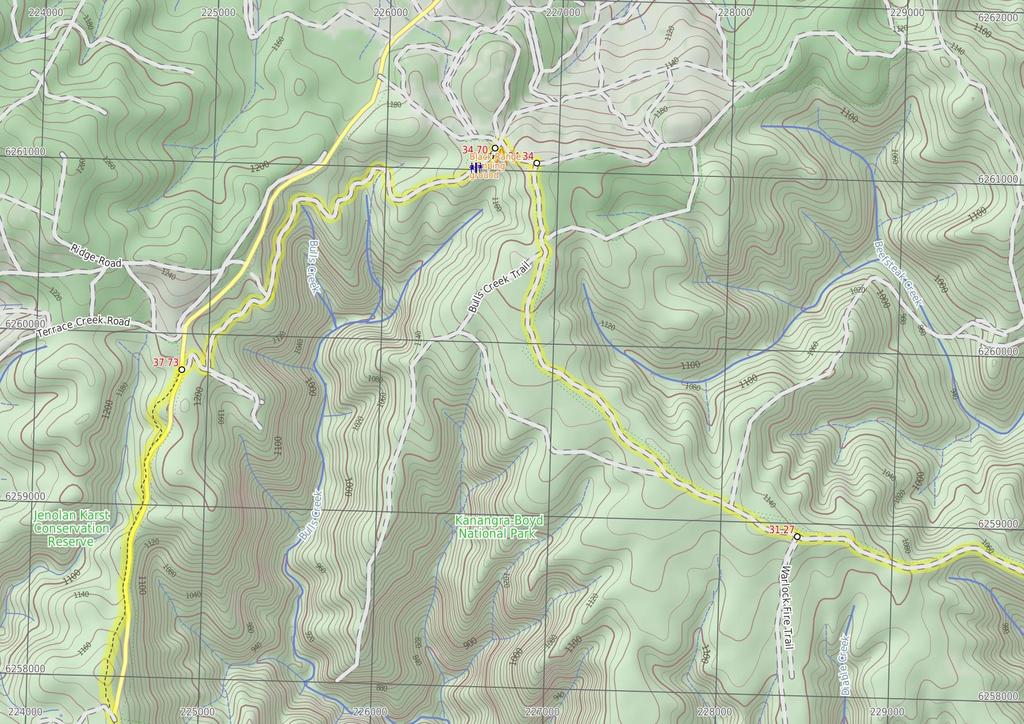
5 15.71 Coxs River Campsite (3.1 km 1 hr 10 mins) Turn right: From the intersection, this walk follows the 'Six Foot Track' sign uphill along the dirt road passing alongside the Coxs River Campsite (which is on your right). After about 150m this walk crosses the usually shallow Gibraltar Creek that leads uphill for another 150m to pass close to a high tension power line tower (up the hill to your left). The walk continues up along the dirt road for 200m to cross a usually small creek then heads under the high tension power lines to cross the usually usually shallow Gibraltar Creek again. These creeks may become impassable after heavy or prolonged rain, they also often dry up. From here the dirt road winds moderately steeply uphill for about 2.1km where it then passes around a left hand hairpin bend to pass another 'Drive With Caution Walkers On Road' sign (where there is also some views to your left). The road leads more gently uphill where it then bends right to lead gently past the top of the Kiangatha Yards to cross a cattle grate on the dirt road Kiangatha Yards (3.1 km 1 hr 14 mins) Continue straight: From beside Kiangatha cattle Yards this walk heads north west along the dirt road to cross a small dip and head straight through an intersection and continue for 250m to pass a 'Grid' sign (facing away). About 140m later this walk pass another 'Grid' sign then 100m after crosses another cattle grid. The walk continues (moderately steeply in places) up the dirt road for 700m where it flattens out mostly at a grassy clearing with view of the distant escarpment (behind). Here the dirt road leads more consistently and steeply uphill for 300m until suddenly flattening out on at the top of Mini Mini Saddle, beside a large clearing (on your left). Continue straight: From beside the Mini Mini Saddle clearing, this walk follows the dirt road gently uphill along the side of the hill. The road leads past a open section of forest and starts to head downhill to pass a 6FT '20km' arrow post about 250m after leaving the clearing. Here the track leads downhill, moderately steeply in places for 900m where the road bends left around the edge of a grassy clearing. About 40m further down the road, this walk passes an intersection with the regenerating trail (on your right) and continues steeply downhill for just shy of 300m to turn left at the intersection at the other end of the regenerating trail. This walk continues more gently downhill along the dirt road for just over 350m until coming to the signposted (and gated) 'Alum Creek Reserve' (on your right) Alum Creek Camping ground Signposted as 'Alum Creek Reserve', this fairly flat grassy area, off the side of the dirt Glen Chee Road, part of the six foot track). The campsite is the least used and least developed of the three official campsites on the Six Foot Track, and makes a good place to stay if attempting the walk in two days. There are no facilities provided but the flat campsite is in a well-protected valley with the small Alum Creek beside the campsite and the fairly reliable Little River down the road (treat water before use) Alum Creek Reserve (4.2 km 1 hr 32 mins) Continue straight: From 'Alum Creek Reserve', this walk follows the dirt road downhill for just shy of 100m to cross Alum Creek. Here the walk heads up between the two timber posts and heads through old farmland for about 300m to pass a 'Drive with Caution Walkers on road' sign (facing away). Over next 300m this walk continues through the old farmland, then leads beside Little River before crossing the usually shallow Little River. Just over 100m later this dirt road leads across the river again, then again after another 110m. These creeks may become impassable after heavy or prolonged rain, and may become dry. The dirt road now starts to head uphill for about 300m where it then bends right around a hand hairpin bend then a short distance further up to the 'Kiangatha' gate. Continue straight: From here, this walk heads up through the Kiangatha Gate and continues walking fairly steeply uphill along the dirt road. After about 500m the road leads around a left hand hairpin bend then 150m later the road briefly flattens out beside a large flat clearing (on your left). The walk continues steeply uphill for 800m to walk past a 'Drive with Caution Walkers On Road' sign (facing away) to come to a Y-intersection with the signposted 'Waterfall Creek Fire Trail' (on your right). Turn left: From the intersection, this walk follows the arrow on the metal post quiet steeply uphill along the dirt road. After about 400m this walk passes a '20km' 6FT arrow post then about 150m later the road flattens out briefly to pass a clearing on the top of the ridge (on your left). The dirt road continues to wind fairly steeply uphill for another 700m with some distance views of the escarpment behind before passing around a sharp left hand hair pin bend. Just shy of 150m later this walk comes to a clearing at the top if Black Range, marked with a few 6FT signs and the intersection with the signposted 'Cronje Mountain Fire Trail' Int. Black Range Rd and Cronje Mtn Fire Trail (2.1 km 38 mins) Veer right: From the intersection, this walk follows the '6`t' arrow on metal pole generally west along main dirt road that follows the top of the ridge line. The dirt road undulates along the ridge line for 2.1km, moderately steeply in a few places through a wooded forest and past a few large ant mounds until leading up to the signposted intersection with 'Moorara Boss Fire Trail' (on your left) Int. Black Range Rd and Moorara Boss Fire Trail (3.2 km 57 mins) Continue straight: From the intersection, this walk follows the '6`t' arrow on metal pole west and uphill along the main dirt road that follows the ridge line. After about 100m this walk heads past a small dam on the side of the road then continues along the dirt road as it gently undulates through the pleasant open forest for 2.3km before heading up a short steep section. About 900m from the top of this steep section the road leads fairly gently up to and intersection with the signposted 'Warlock Fire Trail' (on your left) Int. Black Range Rd and Warlock Fire Trail (3.1 km 51 mins) Continue straight: From the intersection, this walk follows the arrow on the metal '6`T' post west along the main dirt road. After just shy of 100m this road splits in two for a short distance then almost 400m later this walk comes to an intersection with the signposted 'Beefsteak Creek Fire Trail' (on your right). Continue straight: From the intersection, this walk follows the '6`t' arrow on a metal post north west, uphill along the main dirt road. Soon the road leads up a short steep rise then leads more gently as it undulates along the ridge for 400m to pass straight ahead at an intersection marked with a metal 'Kanangra Boyd National Park' sign. This walk continues along the main dirt road for another 1.2km to pass a short trail (on your right, that leads into a clearing that has been used as a campsite). Here the dirt road continues gently uphill for 500m to find an intersection with a faint trail (on the left), just before the clearing and pine forest. Continue straight: From the intersection, this walk heads north and gently uphill along the main trail, towards the clearing. After about 80m the dirt road leads past a 'Black Range Fire Trail' sign then about 25m later comes to the edge of the clearing and intersection with another trail. Here the walk continues straight and gently up along the main dirt road for 400m as the road bends right to a T-intersection on the edge of the pine forest, marked with a '6`t' metal arrow post Black Range Rd (360 m 8 mins) Turn left: From the intersection, this walk follows the '6`t' metal arrow post downhill along the dirt road keeping the main pine forest to your right. After about 250m this walk comes to a clear four way intersection marked with several 'Six Foot Track' signs, and some power lines on your left. Turn left: From the intersection, this walk follows the 'Six Foot Track - Black Range Camping Ground' sign gently downhill and some under power lines along the dirt road. After about 50m this walk heads past a 'Drive With Caution Walkers On Road' sign then another 50m later comes to an information sign in front of the 'Black Range Camping Ground' (on your right) Black Range camping ground Black Range camping ground is found along the Six Foot Track, and is also accessible by car. The well maintained and signposted campsite has a couple of sheltered picnic tables, toilets, rainwater tank and and information board with map. The campsite is in a large fenced grassy area. The tank water is quiet reliable but the tank can become empty during long dry spells or through vandalism, please treat before use. A sign reminds campers that this is a Fuel Stove Only area - no camp fires 34.7 End of day 2 This is the planned overnight stay for the end of day 2, happy camping.
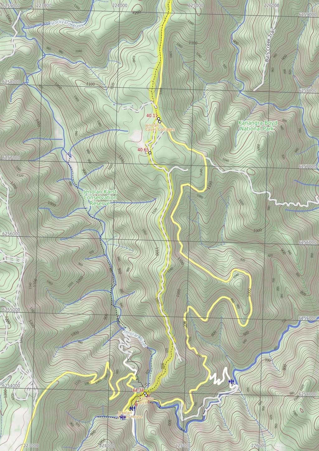
6 34.7 Black Range Campsite (3 km 1 hr 5 mins) Continue straight: From the information sign in front of 'Black Range Camping Ground', this walk follows the dirt road gently downhill initially keeping the campsite to your right. After about 100m this walk leaves the edge of the campsite and comes to an intersection with a management trail (on your left), marked with a 6FT arrow post. Continue straight: From the intersection, this walk follows the 6FT arrow post gently downhill (south west) along the management trail through the tall wooded forest. After almost 200m this walk passes a '10km' 6FT arrow post then about 400m later the trail bends right and heads more steeply downhill for about 200m where the trail bends left to cross a ferny gully (the upper reaches if Bulls Creek). The walk continues along the trail heading uphill past a few more 6FT arrow posts for about 500m to a clearing at the top of the ridge. Here the trail bends and leads downhill through tall eucalypt forest with some pine trees for 250m to veer left at an intersection with a faint trail (on your right). The walk now continues up the moderately steep hill keeping the valley on the left for just shy of 300m to then head up a notably steeper section of trail with a few Telsta posts for about 250m. About 40m from the top of this climb the walk comes to a clear intersection with a trail (on your right), marked with 6FT arrow post. Continue straight: From the intersection, this walk follow 6FT arrow post south west gently downhill along the clear trail. After about 50m the trail bends right then leads fairly steeply downhill for 250m to a pleasant gully. The trail then gently undulates along the side of the hill for 300m to find a Tintersection, marked with a 6FT arrow post (pointing right). Veer right: From the intersection, this walk follows the 6FT arrow post gently uphill along the trail heading north west. After about 120m this trail bends left (at a large grassy clearing) then just over 100m later the trail passes a 'Road Ahead' sign and comes to a larger clearing and gravel stock pile beside the sealed Jenolan Caves Rd, Int of 6 ft track and Jenolan Caves Rd (2.4 km 49 mins) Continue straight: From the clearing and gravel pit, this walk crosses Jenolan Caves Road (take care with traffic) veering a little left to follow a 6FT arrow post along the narrow track. Here the track leads past a 'Road Ahead' sign (facing away) and winds gently along the side of the hill for about 300m before turning right, following a 6FT arrow post, down some timber steps. After another 40m this walk crosses a ferny gully and small creek on a small flat timber plank bridge. Here the walk heads along the side of the gully and up timber steps for about 100m before flattening out and heading around the side of the hill for another 200m. Here the walk comes beside the road and heads just behind the safety barrier for about 30m before heading around the side of another small hill for 120m. Here the walk turns right and follows another 6FT arrow post down some timber steps for about 80m to cross another gully on another small flat timber plank bridge. The walk now heads up more timber steps for about 40m where the track flattens out near the road again. Turning right the walk now heads around the side a small hill for 40m before once again turning right and following the 6ft arrow post down timber steps across a gully then head up the hill for 130m to the large blue 'Jenolan Caves Welcome' sign. The track now widens (into an old trail) and follows fairly close to road and power lines for 400m before bending right to lead up over a hill for about 600m (passing a '5km' 6FT arrow) to then come down and walk along side of a vegetating clearing and come back to the road. From here this walk follows the track keeping the road a short distance to your left for 150m to an intersection with driveway near a large blue 'Jenloan Caves Cottages' sign Jenolan Caves Cottages Administration (540 m 11 mins) Veer right: From the intersection, this walk follows the 'Cottages' sign along the driveway past the '20' km/h speed limit sign, initially keeping the office/house to your left. The driveway leads over a small rise then heads downhill for about 300m to pass a toilet block. Here the walk stays on the driveway as it bends left and continues beside the clearing to come beside the cottages Jenolan Caves Cottages Located 9km from Jenolan Caves by road, Jenolan Caves Cottages offers eight well presented self contained timber cottages for guests to stay in. Each is fully insulated and furnished, with lounge, kitchen, two bedrooms and linen. The is a large flat grassy area in front with often with kangaroos grazing and with a children's playground. For more information call the Jenolan Caves on The cottages have a two night minimum stay and prices are from around $130 per night per cabin Jenolan Caves Cottages (3.7 km 1 hr 22 mins) Continue straight: From beside Jenolan Caves Cottages, this walk heads gently uphill along driveway (initially keeping the cottages to your right) for about 60m to walk around the metal gate beside 'Six Foot Track' sign. This walk continues along this mostly flat trail for 350m through tall wooded forest to a T-intersection marked with a 'Kia-ora Hill Fire Trail' sign. This walk turns right and follows 'Six Foot Track' sign gently down along the trail for about 300m to find a fairly large flat clearing. The walk continues along the trail which generally leads downhill along the ridge line for 1.5km to where the trail moves to the side of the steep valley (on your right). The trail begins to become steeper then after 400m the trail leads particularly steeply down along the rocky trail for about 600m. Here the trial flattens out on a saddle with a Y-intersection marked with a 'Six Foot Track' sign (pointing right) and a 'Mt George' sign (pointing ahead). Veer right: From the intersection, this walk follows the 'Six Foot Track' sign downhill along the narrowing track, keeping the steep wide valley to your right. After about 25m the track leads between two timber posts and continues fairly steeply down the side of the valley with glimpses to the cave buildings for 500m where the track flattens out a bit and heads under a solid gum tree leaning over the track. The track continues leading downhill for another 300m to cross a narrow saddle and along a very narrow ridge where there are good views down to Blue Lake (on your left). The track now leads down some timber steps for about 50m to a T-intersection with a gravel path where a 'Six Foot Track' sign points back uphill. Turn left: From the intersection, this walk follows the 'Caves House' sign gently downhill along the gravel path a short distance to an intersection and fenced lookout near 'Carlotta Arch' (on your left) Carlotta Arch Carlotta Arch is a large and spectacular cave remnant overlooking Blue Lake. It is believed that the arch was named in honour of a daughter of a surveyor General P.F. Adams. Adams is credited with having taken some of the earliest photos at Jenolan Carlotta Arch Lookout (410 m 12 mins) Continue straight: From the fenced lookout near 'Carlotta Arch', this walk follows the 'Caves House' sign gently uphill along the stone path with handrail. The path leads over a small rise to a view into another valley. Here the path begins to zig zag fairly steeply downhill for 150m beside the limestone cliffs passing views down to Caves House, past a bench seat to a 'Caves House' information sign. The path continues more gently downhill for another 100m past the 'Grand Arch' information sign (and view of the Arch) then just over 30m later to the 'Southside Show Caves' information sign. The path continues down the side of the valley for another 80m to head down some concrete steps to the side of Jenolan Caves Road, opposite Caves House, where a 'Six Foot Track' sign points up the steps. The official end of the Six Foot Track Jenolan Caves House Jenolan Caves House, built in 1898, is a heritage-listed building which houses dining, a variety of accommodation options, and other services for visitors to the caves. Jenolan has two licensed restaurants: Trails Bistro is open from breakfast onwards and closes early evening. Trails serves a range of light meals including sandwiches, salads and hot food. Chisholm's Restaurant is open each morning for breakfast and each evening for dinner from 6.00pm. Essential items and beautiful souvenirs may be purchased from Things Jenolan, located on the ground floor of Caves House. Don't forget to explore one of the many caves to explore in the area. For more information, call Jenolan Caves on
7
8
9
10
11
12
13 Summary navigation sheet for the Six Foot Track km From Start Explorers Tree , (GR Katoomba, ) Up/Dwn Length Initial directions (Use full tracknotes and maps for more detail) m 5 mins From the 'Explorers Tree' (at the intersection of Nellies Glen Rd and the Great Western Hwy), this walk follows the 'Six Foot Track - 200m' sign up along the sealed Nellies Glen Rd for just over 200m before turning m 12 mins 210 m 6 mins 1.6 km 44 mins 2 km 36 mins 90 m 1 mins 1.1 km 18 mins 1.5 km 26 mins Continue straight: From the shelter and car park (on Nellies Glen Rd), this walk follows the 'Six Foot Track' sign around the lower locked metal gate to follow the management trail gently downhill. Optional sidetrip to Norths Lookout. Continue straight: From the intersection, this walk heads through the gap in the large metal gate, over a small rise. Turn right: From the intersection, this walk follows the 'Six Foot Track' sign, fairly steeply down the management trail past the 'Nellies Glen' metal plaque and, about 10m later, past the timber 'Nellies Glen' sign. Veer left: From the clearing, this walk follows the wide trail gently downhill while keeping the valley to your right. Continue straight: From the intersection, this walk walk follows the 'Six Foot Track' sign along the Nellies Glen trail, to cross the culverted Diamond Creek to then come pass alongside the old Megalong 'Village sit... Continue straight: From the beside the historic Megalong 'Village site', this walk heads along the wide trail, initially keeping the horse paddock and view to the escaprment to your left after just shy of 250m this... Veer right: From the intersection, this walk heads west along the Nellies Glen Road trail, initially keeping the power lines to your right. Megalong Ford , (GR Hampton, ) 8.23 Int of 6 Foot Track and Megalong Rd , (GR Hampton, ) 8.32 Megalong Cemetery , (GR Hampton, ) 9.09 Int Near Guyver Bridge , (GR Hampton, ) Private Gate , (GR Hampton, ) Bowtells Swing Bridge , (GR Hampton, ) km 22 mins 100 m 2 mins 770 m 15 mins 1.9 km 41 mins 3.4 km 1 hr 25 mins 1.1 km 25 mins Continue straight: From the intersection, this walk follows the 'Six Foot Track' sign over the fence using the stile. Continue straight: From the car park on Megalong Road (about 400m south of Megalong Creek), this walk follows the 'Six Foot Track' sign over the cattle grate or stile and goes beside the large sheltered 'Six Foot Tr... Continue straight: From beside 'Megalong Cemetery', this walk heads gently downhill along the dirt road for about 80m to pass through gate with a 'No Through Road' sign. Turn right: From the intersection, this walk follows the 'Six Foot Track' sign downhill along the narrow track into the valley. Continue straight: From the gate, this walk heads downhill along the narrowing track, keeping the valley to your right. Alternate Route Bowtells Swing Bridge. Continue straight: From the intersection just above above Bowtells Swing Bridge, this walk follows the 'Six Foot Track' sign along the clear track keeping the main valley to your right Bowtells Swing Bridge , (GR Hampton, ) Bowtells Bridge West , (GR Hampton, ) Six Foot Track Lodge , (GR Hampton, ) End of day , (GR Hampton, ) m 4 mins 790 m 20 mins 410 m 8 mins 0m Six Foot Track Info Shelter , (GR Katoomba, ) Int of 6 Foot Track and Norths Lookout Trail , (GR Katoomba, ) Int of Six Foot Track and Norths Lookout Trail , (GR Katoomba, ) Int at Lower Nellies Glen , (GR Katoomba, ) Int of Nellies Glen Rd Trail and Devils Hole Trail , (GR Katoomba, ) Megalong Village site , (GR Katoomba, ) Intersection of Medlow Gap Management Trail and 6 Foot Track , (GR Katoomba, ) 7.09 Turn right: From the intersection, this walk follows the 'Alternative Bridge When River High' sign down the timber steps to the southern end of the 'Bowtells Bridge'. Continue straight: From the north side of the bridge, this walk heads up the timber steps through the dense forest to soon pass the 'Bowtells Bridge' sign. Continue straight: From the intersection below the 'Six Foot Track Lodge', this walk follows the clear track west initially keeping the lodge up to your right. This is the planned overnight stay for the end of day 1, happy camping.
14 Summary navigation sheet for the Six Foot Track km From Coxs River Campsite , (GR Hampton, ) Kiangatha Yards , (GR Hampton, ) Alum Creek Reserve , (GR Jenolan, ) Int. Black Range Rd and Cronje Mtn Fire Trail , (GR Jenolan, ) Int. Black Range Rd and Moorara Boss Fire Trail , (GR Jenolan, ) Int. Black Range Rd and Warlock Fire Trail , (GR Jenolan, ) Black Range Rd , (GR Jenolan, ) End of day , (GR Jenolan, ) Black Range Campsite , (GR Jenolan, ) Int of 6 ft track and Jenolan Caves Rd , (GR Jenolan, ) Jenolan Caves Cottages Administration , (GR Jenolan, ) Jenolan Caves Cottages , (GR Jenolan, ) Carlotta Arch Lookout , (GR Jenolan, ) Powered by TCPDF ( Up/Dwn Length Initial directions (Use full tracknotes and maps for more detail) km 1 hr 10 mins 3.1 km 1 hr 14 mins 4.2 km 1 hr 32 mins 2.1 km 38 mins 3.2 km 57 mins 3.1 km 51 mins 360 m 8 mins 0m Turn right: From the intersection, this walk follows the 'Six Foot Track' sign uphill along the dirt road passing alongside the Coxs River Campsite (which is on your right). Continue straight: From beside Kiangatha cattle Yards this walk heads north west along the dirt road to cross a small dip and head straight through an intersection and continue for 250m to pass a 'Grid' sign (facing... Continue straight: From 'Alum Creek Reserve', this walk follows the dirt road downhill for just shy of 100m to cross Alum Creek. Veer right: From the intersection, this walk follows the '6`t' arrow on metal pole generally west along main dirt road that follows the top of the ridge line. Continue straight: From the intersection, this walk follows the '6`t' arrow on metal pole west and uphill along the main dirt road that follows the ridge line. Continue straight: From the intersection, this walk follows the arrow on the metal '6`T' post west along the main dirt road. Turn left: From the intersection, this walk follows the '6`t' metal arrow post downhill along the dirt road keeping the main pine forest to your right. This is the planned overnight stay for the end of day 2, happy camping. 3 km 1 hr 5 mins 2.4 km 49 mins 540 m 11 mins 3.7 km 1 hr 22 mins 410 m 12 mins Continue straight: From the information sign in front of 'Black Range Camping Ground', this walk follows the dirt road gently downhill initially keeping the campsite to your right. Continue straight: From the clearing and gravel pit, this walk crosses Jenolan Caves Road (take care with traffic) veering a little left to follow a 6FT arrow post along the narrow track. Veer right: From the intersection, this walk follows the 'Cottages' sign along the driveway past the '20' km/h speed limit sign, initially keeping the office/house to your left. Continue straight: From beside Jenolan Caves Cottages, this walk heads gently uphill along driveway (initially keeping the cottages to your right) for about 60m to walk around the metal gate beside 'Six Foot Track' sign. Continue straight: From the fenced lookout near 'Carlotta Arch', this walk follows the 'Caves House' sign gently uphill along the stone path with handrail.
Popes Glen, Pulpit Rock, Govetts Leap and Braeside Walk
 Popes Glen, Pulpit Rock, Govetts Leap and Braeside Walk 8 hrs Hard track 13.6 km Circuit 4 1068m This large circuit walk, from Popes Glen to Pulpit Rock, Govetts leap and along the Braeside Track, passes
Hunters Hill to Epping Road
 Hunters Hill to Epping Road 2 hrs 30 mins 5.5 km One way Moderate track 154m An enjoyable walk through lower sections of the Lane Cove National Park, this walk features plenty of mangroves next to the
Govetts Leap Loop. 1065m. 909m Blue Mountains National Park. 4 hrs 30 mins 8.7 km Circuit. Hard track 380m
 Govetts Leap Loop 4 hrs 30 mins 8.7 km Circuit Hard track 380m This walk, from Blackheath Train Station, is a fantastic way to see some of the iconic areas of the Blue Mountains in the Blackheath area.
Sid Pulsford Walk. 175m. 33m. 1 hr 45 mins 4.1 km One way. Hard track 118m. Gosford LGA
 Sid Pulsford Walk 1 hr 5 mins.1 km One way Hard track 118m Sid Pulsford Walk explores the ridge top of Kincumber Mountain, from Honeman's Rock to Green Point. The walk mostly follows wide management trails.
Wentworth Falls Conservation Hut Loop
 Wentworth Falls Conservation Hut Loop 3 hrs Hard track 6.7 km Circuit 4 341m This scenic walk from Wentworth Falls Station, winds along the Nature Trail to Conservation Hut, then drops into the magnificent
Currie Rd to Davidson Park
 Currie Rd to Davidson Park 3 hrs 7.2 km One way Moderate track 28m Starting at Currie Rd in Forestville, this walk follows Middle Harbour to Davidson Park, under Roseville Bridge. There are two optional
Echo Point to Leura Forest via Three Sisters and Giant Stairs loop
 Echo Point to Leura Forest via Three Sisters and Giant Stairs loop 3 hrs 3.8 km Circuit Hard track 512m This walk starts from the popular Echo Point, in Katoomba, and winds down to the base of the Three
Carrington Park to Leura Forest and pass loop
 Carrington Park to Leura Forest and pass loop 3 hrs Hard track 4.8 km Circuit 4 674m This walk is a fantastic way to see Leura Forest. The walk descends from Carrington Park, visiting Leura Forest and
Sphinx, Warrimoo and Bobbin Head tracks
 Sphinx, Warrimoo and Bobbin Head tracks 4 hrs 9.6 km Circuit Moderate track 499m This great walk starts at the Sphinx Memorial and loops around via Cowan Creek, exploring diverse environments as it changes
Little Digger Track. 68m. 1 Hr 2.2 km One way. Moderate track 93m. Moores Creek Reserve
 Little Digger Track Hr 2.2 km One way Moderate track 93m This walk follows Moores Creek through several reserves in east Roseville and East Lindfield. The track is named after Australia's 7th Prime Minster,
Waterfall to Heathcote
 Waterfall to Heathcote 5 hrs Hard track 10.8 km One way 4 467m This walk explores the heart of Heathcote National Park, and is easily accessed with a train station at either end. Although relatively close
Little Digger Track to Davidson Reserve and Lyrebird Circuit
 Little Digger Track to Davidson Reserve and Lyrebird Circuit 4 hrs 3 mins 11.5 km One way Hard track 4 47m Exploring both the eastern and western sides of Middle Harbour Creek, this walk follows the Little
Wattamolla to Big Marley Beach
 Wattamolla to Big Marley Beach 4 hrs 10.4 km Circuit Moderate track 4m This walk is an excellent loop which takes in both the coast and the heathy inland of Royal National Park. Nearly the whole walk has
Morgans Creek to Padstow
 Morgans Creek to Padstow 2 hrs 45 mins 8 km One way Moderate track 3 144m This pleasant walk starts from the Morgans Creek park, at Henry Lawsons Drive, and follows the Georges River past the Boomerang
Campbell Drive to Snapper Point
 Campbell Drive to Snapper Point 1 hr 45 mins 4.2 km One way Experienced only 135m This walk follows the Coast Track to Frazer Beach, along the Geebung and (overgrown) Grass Tree Tracks. From the northern
Epping to Pennant Hills Station (via Lane Cove River)
") Epping to Pennant Hills Station (via Lane Cove River) 3 hrs 5 mins 8.4 km One way Hard track 249m This walk, from Epping to Pennant Hills Station, is a great way to see the upper Lane Cove River Valley.
Epping to Pennant Hills Station (via Lane Cove River) 3 hrs 5 mins 8.4 km One way Hard track 249m This walk, from Epping to Pennant Hills Station, is a great way to see the upper Lane Cove River Valley.
Epping to Eastwood Station (via Lane Cove River)
") Epping to Eastwood Station (via Lane Cove River) hrs 45 mins 10.2 km One way Moderate track 189m Epping to Eastwood, via Lane Cove River, is the longer route through the bush between the stations. This
Epping to Eastwood Station (via Lane Cove River) hrs 45 mins 10.2 km One way Moderate track 189m Epping to Eastwood, via Lane Cove River, is the longer route through the bush between the stations. This
Hornsby Blue Gum Walk
 Hornsby Blue Gum Walk 3 hrs Hard track 6.7 km Circuit 4 374m This delightful loop is one of the prettiest and most popular walks in the Hornsby area. Going from an environment of ferns and clear bushland
The Basin Track and Mackerel Track
 The Basin Track and Mackerel Track 3 hrs 5.9 km Circuit Hard track 226m This walk is a great way to see some popular areas in Ku-ring-gai Chase National Park. The walk from West Head Rd travels to The
De Burgs Bridge to Thornleigh station
 De Burgs Bridge to Thornleigh station 3 hrs 45 mins 9.7 km One way Hard track 4 363m This walk follows a section of the Great North Walk, starting from De Burghs bridge. The walk winds north west, through
Katoomba Falls Circuit
 Katoomba Falls Circuit hr 5 mins.5 km Circuit Hard track 59m For those looking for a walk involving more than simple boardwalk, this trail winding through the temperate rain forest could be just the thing.
Wallarah Coastal Walk
 Wallarah Coastal Walk 3 hrs 8.3 km Return Hard track 247m This walk starts at Caves Beach and travels south along the coastline, until reaching the Pinney s Headland Lookout. There are many opportunities
Dead Horse Gap Loop track
 Dead Horse Gap Loop track 4 hrs 30 mins Hard track 9.8 km Circuit 144m 4 This walk starts with a ride up the Kosciuszko Express Chairlift. There is an opportunity to eat at Australia's highest restaurant,
The Foreshore Walk. 24m. 1m Lake Macquarie LGA. 1 hr 15 mins 2.9 km One way. Hard track 81m
 The Foreshore Walk 1 hr 15 mins 2.9 km One way Hard track 81m This walk traverses the coastline of the Green Point reserve. By following a variety of tracks and occasionally traveling inland through eucalyptus
Heathcote to Engadine via Audley
 Heathcote to Engadine via Audley 6 hrs 3 mins 5 km One way Hard track 4 635m Covering a large section of central Royal National Park, this walk goes through the heath and scrub along a well managed and
Berowra to Mt Kuring-gai
 Berowra to Mt Kuring-gai 4 hrs 30 mins 9.4 km One way Hard track 4 551m From the ridges above Cowan Creek, this walk takes in some great lookouts (especially around Mt Kuringgai) as well as enjoying an
Teralba to Charlestown Park track head
 Teralba to Charlestown Park track head 4 hrs 30 mins 13.3 km One way Moderate track 3 220m This section of the Great North Walk starts from the Teralba train station and winds down and around the edge
Under and Over Cliff Walk
 Under and Over Cliff Walk 4 hrs 9.4 km Circuit Moderate track 576m This walk from Wentworth Falls Station is a fantastic way to see a large majority of the Wentworth Falls cliffline. The track winds under
Mackerel Beach, West Head Loop
 Mackerel Beach, West Head Loop 5 hrs 8.6 km Circuit Hard track 422m The Mackerel Beach, West Head Loop is a walk which explores a large part of the West Head. The journey starts and finishes with a ferry
Scenic World to Echo Point
 Scenic World to Echo Point 1 hr 15 mins 2.1 km One way Moderate track 192m This is one of the most popular tourist walks in the Katoomba area. The walk follows the cliffs along a well maintained and signposted
National Pass from Wentworth Falls to Conservation Hut
 National Pass from Wentworth Falls to Conservation Hut 3 hrs Hard track 3.6 km One way 739m Starting at Wentworth Falls picnic area, this scenic and historic walk explores many waterfalls, lookouts and
Blackheath Station to Junction Rock Loop (via Grand Canyon and Popes
 Blackheath Station to Junction Rock Loop (via Grand Canyon and Popes 8 hrs 30 mins 18.2 km Circuit Hard track 4 1254m This circuit starts in Blackheath and heads down into the Grand Canyon and Rodriguez
Dubbo Gully and Ten Mile Hollow Circuit (via Clares Bridge)
") Dubbo Gully and Ten Mile Hollow Circuit (via Clares Bridge) 2 Days Hard track 24.3 km Circuit 4 1117m This two day (or ten hour) walk follows several historic roads, now closed to traffic. Starting with
Dubbo Gully and Ten Mile Hollow Circuit (via Clares Bridge) 2 Days Hard track 24.3 km Circuit 4 1117m This two day (or ten hour) walk follows several historic roads, now closed to traffic. Starting with
Rail to River Walk. 3 hrs. Hard track 7.5 km Circuit. 222m
 Rail to River Walk 3 hrs Hard track 7.5 km Circuit 4 222m This walk is a great one from Chatswood Station to the Lane Cove River National Park. The walk descends through the vegetated bushland which fills
Green Point Circuit Walk
 Green Point Circuit Walk 3 hrs 7.7 km Circuit Hard track 269m This walk visits all of the popular locations in Green Point Reserve, as well as some of the lesser-visited areas inland. Taking in Sea Eagle
Patonga to Woy Woy. 5 hrs 45 mins 15.5 km One way. Hard track. 497m
 Patonga to Woy Woy 5 hrs 45 mins 15.5 km One way Hard track 4 497m This walk explores a variety of environments from the shore line and coastal cliffs near Patonga, to the dry, rocky and open ridge line.
Balmoral Beach to The Spit
 Balmoral Beach to The Spit 2 hrs 30 mins.3 km One way Hard track 85m This walks follows the coast from Balmoral to the Spit and across Spit Bridge. There are some alternate tracks to consider at high-tides,
De Burghs Bridge to Fullers Bridge
 De Burghs Bridge to Fullers Bridge 2 hrs 3 mins Hard track 6 km One way 2m 4 Following the Lane Cove River, this walk mostly follows a section of the Great North Walk and is well maintained and signposted.
Federal Pass Walking Track
 Federal Pass Walking Track 5 hrs Hard track 8 km One way 4 989m This classic trail follows along the base of the cliffs from Leura to the Golden Stairs, passing many of the more popular sights of the Katoomba
Epping to Gordon Station
 Epping to Gordon Station 4 hrs 15 mins 11.7 km One way Hard track 4 365m This walk, from Epping Station to Gordon Station, passes below the homes which sit on the hills high above the Lane Cove River.
Callicoma Loop. 174m. 98m. 2 hrs. Hard track 5.1 km Circuit. 153m
 Callicoma Loop 2 hrs Hard track 5.1 km Circuit 153m This great circuit walk passes through some really nice forest around the fringe of Cherrybrook. Highlights of the walk include some beautiful rock overhangs
Wentworth Falls Station Loop (Undercliff Walk)
") Wentworth Falls Station Loop (Undercliff Walk) 4 hrs 3 mins Hard track 8.9 km Circuit 658m 4 This walk passes some stunning waterfalls and views into the Jamison Valley, following the cliff edges around
Wentworth Falls Station Loop (Undercliff Walk) 4 hrs 3 mins Hard track 8.9 km Circuit 658m 4 This walk passes some stunning waterfalls and views into the Jamison Valley, following the cliff edges around
Mackerel Beach and Resolute Loop
 Mackerel Beach and Resolute Loop 3 hrs 5.4 km Circuit Hard track 384m This walk is another great walk in Ku-ring-gai Chase National Park, accessed by ferry. From the Mackerel Beach wharf, this walk uses
Middle Harbour Creek Loop
 Middle Harbour Creek Loop 5 hrs 45 mins 15.1 km Circuit Experienced only 5 570m This walk explores the upper reaches of Middle Harbour Creek, starting and ending at the great parklands at Davidson Park,
Rail to River and Stringybark Creek Reserve Walk
 Rail to River and Stringybark Creek Reserve Walk 4 hrs Hard track 11.2 km Circuit 4 302m This walk begins in the busy city of Chatswood and soon enters the nearby bushland around the Lane Cove River. The
Glenbrook and Euroka Circuit
 Glenbrook and Euroka Circuit 2 Days 16.6 km Circuit Experienced only 790m This two day circuit, returning to Glenbrook Station, is a scenic walk which passes many of the tourist attractions within the
Thornleigh to Hornsby
 Thornleigh to Hornsby 4 hrs Hard track 10.2 km One way 4 526m Starting at Thornleigh station you walk through suburban streets for a short while before diving into the bush at the southern end of Berowra
Upper Rumbalara circuit
 Upper Rumbalara circuit 1 hr 30 mins 3.3 km Circuit Hard track 176m A great circuit walk, covering most of the walking tracks and sights in the upper section of the Rumbalara Reserve. There is some really
Woolwich Wharf to Boronia Park
 Woolwich Wharf to Boronia Park 2 hrs 5.8 km One way Moderate track 175m Going through the streets of Hunters Hill, this walk is on the first segment of the Great North Walk. The majority of the walk is
Roseville to Macquarie Park
 Roseville to Macquarie Park 3 hrs 3 mins 8.8 km One way Hard track 4 29m This walk starts at Roseville station and explores the streets and alleyways of Roseville before joining the main spine of the Great
Taronga Wharf to Chowder Bay
 Taronga Wharf to Chowder Bay 2 hrs 4.4 km One way Moderate track 246m Starting at Taronga Wharf, this walk passes many icons of Sydney, including Taronga Zoo, HMAS Sydney Mast, Chowder Bay. The walk also
Wentworth Falls Loop. 893m. 665m. 6 hrs 10.2 km Circuit. Hard track 1093m. Blue Mountains National Park
 Wentworth Falls Loop 6 hrs 1.2 km Circuit Hard track 193m This is a great walk, both in size and spectacular views. The walk makes its way from Wentworth Falls train station and drops off the plateau,
Bouddi Coastal Walk. 5 hrs. Hard track 8.1 km One way. 364m
 Bouddi Coastal Walk 5 hrs Hard track 8.1 km One way 4 364m This is one of the longer walks in the Bouddi National Park and it is rich in scenery. The walk follows the coastline with many side trips to
Echo Point to Leura Forest Circuit
 Echo Point to Leura Forest Circuit 3 hrs 4.8 km Circuit Hard track 588m Forming a circuit around the cliffs and then the valley floor, this is a walk more then capable of convincing a walker of the beauty
Spit Bridge to Middle Head Forts
 Spit Bridge to Middle Head Forts 2 hrs 30 mins 6.3 km One way Hard track 4 181m This scenic walk takes you from the Spit Bridge, along the coast to explore the Middle Head Forts. There are a few alternate
Hermitage Foreshore Track
 Hermitage Foreshore Track 1 Hr 2.2 km One way Moderate track 123m The Hermitage Foreshore Walk is a wonderful way to explore Sydney Harbour from the perspective of South Head. This walk starts from Nielsen
Sphinx to Mt Kuring-gai
 Sphinx to Mt Kuring-gai 4 hrs 45 mins 1.7 km One way Hard track 673m This walk starts at the Sphinx War Memorial and follows some well maintained and popular walking tracks down to Cowan Creek. Enjoy the
Lane Cove Tourist Park River Circuit
 Lane Cove Tourist Park River Circuit 5 hrs 12 km Circuit Hard track 383m This walk follows a large section of Lane Cove River. The walk follows the Riverside Walking track up the Lane Cove River to De
Wentworth Falls Station Loop
 Wentworth Falls Station Loop 5 hrs 3 mins 9.5 km Circuit Hard track 4 13m The Wentworth Falls Station Loop takes in most of the upper tracks around Wentworth Falls. There are many scenic views near the
Charlestown Park trackhead to Newcastle station
 Charlestown Park trackhead to Newcastle station 5 hrs 30 mins 12.1 km One way Hard track 4 287m This section of the Great North Walk starts from the Charleston Park track head and winds through the streets
Faulconbridge to Blaxland
 Faulconbridge to Blaxland 2 Days Experienced only 15.2 km One way 5 693m This two-day walk, or very solid one-day walk, takes you from station to station, through lush, scenic forest in the lower Blue
North Ryde Fairyland circuit
 North Ryde Fairyland circuit 2 hrs 30 mins Hard track 6.9 km Circuit 193m 4 Starting at North Ryde train station this walk explores a stretch of the Lane Cove River, visiting the historic Fairlylands Pleasure
Gordon to Chatswood Station
 Gordon to Chatswood Station 4 hrs 30 mins 12.2 km One way Hard track 4 381m This walk is a great way to get into the bush without being far from civilisation. The walk wanders through untouched valleys
Bobbin Head Loop. 166m. 0m Ku-ring-gai Chase National Park. 5 hrs 12.9 km Circuit. Hard track 619m
 Bobbin Head Loop 5 hrs 12.9 km Circuit Hard track 619m This great circuit walk enjoys a variety of landscapes in Ku-ring-gai Chase National Park. The walk starts at the historic Sphinx war memorial and
The Coast Track. 2 Days. Hard track 27.4 km One way. 1351m
 The Coast Track 2 Days Hard track 27.4 km One way 4 1351m Heading south, this walk covers the coastline of the Royal National Park and can truly only be described as amazing. With breathtaking coastal
Scenic world to Three Sisters Loop via Furber Steps
 Scenic world to Three Sisters Loop via Furber Steps 5 hrs 5.8 km Circuit Hard track 722m This walk starts from the popular Scenic World, in Katoomba, and winds down the Furber steps into the Jamison Valley,
Narrabeen Lagoon Trail (from Middle Creek)
") Narrabeen Lagoon Trail (from Middle Creek) 2 hrs 30 mins 8.6 km Circuit Very easy 1 105m The Narrabeen Lagoon Trail is a wonderful and accessible walk on the Northern Beaches of Sydney. The trail is used
Narrabeen Lagoon Trail (from Middle Creek) 2 hrs 30 mins 8.6 km Circuit Very easy 1 105m The Narrabeen Lagoon Trail is a wonderful and accessible walk on the Northern Beaches of Sydney. The trail is used
Gosford to Lisarow. 202m
 Gosford to Lisarow 4 hrs 3 mins Hard track 11.3 km One way 4 479m This walk is a great way to explore the ridge-top bushland between Gosford and Lisarow. Passing through Rumbalara and Katandra Reserves,
Chatswood to Epping Station
 Chatswood to Epping Station 6 hrs Hard track 16.3 km One way 4 533m This walk, from Chatswood to Epping, is a long but enjoyable walk along the Lane Cove valley. The walk mostly follows the Lane Cove River
Rumbalara Explorer. 158m. 5m Rumbalara Reserve. 2 hrs 45 mins 6.1 km Circuit. Hard track 326m
 Rumbalara Explorer 2 hrs 5 mins 6.1 km Circuit Hard track 326m Pretty well the grand tour of the Rumbalara Reserve, this walk takes in much of the great scenery the reserve has to offer. The walk covers
Spit Bridge to Manly (Manly Scenic Walkway)
") Spit Bridge to Manly (Manly Scenic Walkway) 3 hrs 45 mins 9.1 km One way Moderate track 349m The Spit to Manly walk is a classic bushwalk on Sydney's Northern Beaches. The walk follows a well-maintained
Spit Bridge to Manly (Manly Scenic Walkway) 3 hrs 45 mins 9.1 km One way Moderate track 349m The Spit to Manly walk is a classic bushwalk on Sydney's Northern Beaches. The walk follows a well-maintained
Cape Banks Circuit. 50m. 2m Botany Bay National Park. 3 hrs 7.3 km Circuit. Hard track 190m
 Cape Banks Circuit 3 hrs 7.3 km Circuit Hard track 19m This Cape Banks Circuit has a lot to offer and is thoroughly recommended. The walking travels over beaches, through coastal forest and across exposed
Bouddi Ridge and Coastal Walk
 Bouddi Ridge and Coastal Walk 2 Days Hard track 27 km Circuit 4 126m This overnight walk takes in the majority of the magnificent Bouddi National Park. The walk starts from the pleasant Putty Beach camping
Manly to Seaforth Oval
 Manly to Seaforth Oval 5 hrs 45 mins 13.7 km One way Moderate track 3 624m This walk follows the Manly to Spit Scenic Walkway, then continues past The Spit Bridge to Seaforth Oval. The walk provides magnificent
Light to Light Walk 2 days
 Light to Light Walk 2 days 2 Days Hard track 3.9 km One way 4 794m Over two days, this classic walk explores the coast from Boyd Tower to the Green Cape Lighthouse in the south. Hegartys Bay Camp is over
Taronga Zoo to Spit Bridge
 Taronga Zoo to Spit Bridge 5 hrs Hard track 1.4 km One way 4 41m This is a scenic and culturally rich walk with views over Sydney Harbour and many interesting heritage buildings along the way. The start
Sydney to Thornleigh via Lane Cove Tourist Park
 Sydney to Thornleigh via Lane Cove Tourist Park 2 Days 33 km One way Hard track 4 1114m This overnight walk starts from the Obelisk in Macquarie Park, Sydney, at the official start of the Great North Walk.
ULTRA-TRAIL AUSTRALIA May 2018 COURSE DESCRIPTION AND COURSE NOTES
 ULTRA-TRAIL AUSTRALIA 100 19-20 May 2018 COURSE DESCRIPTION AND COURSE NOTES LEG 1 Scenic World (Start) to Narrow Neck (Checkpoint 1) Course Description: From the start, at the front entrance of Scenic
Hammer Vale and Linchmere Common
 point your feet on a new path Hammer Vale and Linchmere Common Distance: 9 km=5½ miles or 6 km=3¾ miles easy walking with one steep section Region: Hampshire, West Sussex Author: Botafuego Refreshments:
6 FOOT TRACK NOTES
 6 FOOT TRACK NOTES - 2008 1. Approaching the 6 foot Event in SECTIONS Race has 4 sections on page 2 onwards below [in blue font] are notes to accompany Sean s race description. Also included: 6 Foot Course
Beautiful Walks from the Blue Ball Inn
 Walk No. 7 COAST AND VALLEY WALK Countisbury, Glenthorne, County Gate, Brendon, Rockford and Wilsham 10 MILES APPROX. Walking time 5 hours approx. (not including breaks)> OS Sheet 64/74 Lynton and Lynmouth.
ST. AGNES. you cannot put a time limit on beauty.
 ST. AGNES CIRCULAR WALKS AROUND There are many enjoyable and picturesque walks around St. Agnes most are signposted and are featured on the St. Agnes Mini-guide map. Because most of our footpaths are in
Calaveras Big Trees State Park--South Grove Loop
 Copyright 1999 by Jeff Robinson. You are free to use and reproduce this description for personal, not-for-profit, and not-forbusiness use. Any reproduction other than for personal use, including businesses,
Detailed maps, and portaging and camping information follow.
 Overview of Bain route. The launch site is at Davidson Lake, just before the Manitoba/Ontario border. You can do a loop if you leave a vehicle at Tulabi Lake (at the canoe route parking lot). The road
LDWA SOUTH DOWNS MARATHON 13 th MAY 2018
 AHD ahead SDW South Downs Way BL/BR bear left/bear right TL/TR turn left/turn right X cross LEG 1 - EAST DEAN to WP1 NORTON GR 470019. Open 1030 to 1300. 9.7 miles. 1.1 From village hall TL and walk to
Winterfold Wood. point your feet on a new path. In Brief
 point your feet on a new path Winterfold Wood Distance: 8½ km=5¼ miles Region: Surrey Author: Schwebefuss Refreshments: Windmill Inn, Peaslake after the walk moderate walking with many gradients Date written:
Tideswell to Castleton
 Tideswell to Castleton 1 Walk summary Length: 14 km, 8.5 miles Maps: OS Explorer OL1 The Peak District - Dark Peak Area, OS Explorer OL24 The Peak District - White Peak Area, OS Landranger 110 Sheffield
The North Pennines from near Langwathby
 3.6 Langwathby to Armathwaite Map panel?? Distance 12.7 miles (20.5 km) Terrain farm, woodland and riverside paths; some potentially muddy tracks; a few short sections of road Grade gently undulating Food
A mainly flat walk along the Peak Forest Canal to Castle Hill and returning along the River Tame via Hulmes Wood and Haughton Dale.
 Walk 9 Haughton Green, Peak Forest Canal, Castle Hill, Hulmes Wood, River Tame, Haughton Dale Circular Miles: 3.9 Time: 1 Hour 30 Minutes Grade: Easy To Moderate Starting Point: Junction Of Gibraltar Lane/Newport
Rhossili - Tears Point - Mewslade Bay - Talgarth's Well - Rhossili - ID: 148. Walk description:
 Walk description: A glorious walk combining thrilling cliffs with beautiful wild beaches and a bird's-eye view of the Gower peninsula from Rhossili Down. The adventurous can walk out to the Worm's Head
PRE-APPROVED WALKS. RED HANDS CAVE CIRCUIT Grade: Easy Description: A circuit walk from either the causeway or the Red Hands Cave parking area. 8km.
 Bushwalking Club Inc. PO Box 126 NSW 2777 www.springwoodbushwalker.org.au PRE-APPROVED WALKS The purpose of this list of pre-approved walks is to enable leaders to put on walks at very short notice (up
Falls Lake Trail (A part of the NC Mountains-to-Sea Trail) East to West
 East to West") Falls Lake Trail (A part of the NC Mountains-to-Sea Trail) East to West Section 1 (Falls of the Neuse Rd to Raven Ridge Rd) 0.0 mi Parking area of the Tailrace Fishing Area, just below the dam, off Falls
Falls Lake Trail (A part of the NC Mountains-to-Sea Trail) East to West Section 1 (Falls of the Neuse Rd to Raven Ridge Rd) 0.0 mi Parking area of the Tailrace Fishing Area, just below the dam, off Falls
RILLINGTON TO MALTON by Tania Dickinson
 RILLINGTON TO MALTON by Tania Dickinson This walk takes you from the Vale of Pickering up on to the Wold scarp, before dropping down again through the pretty village of Settrington and joining the Centenary
Times. S E S/Rd(E) Wakefield Road) Wakefield Rural Fire Brigade
 Wakefield Road) Wakefield Rural Fire Brigade") START On York Street, Teralba adjacent to Tulkaba Park Sports Pavilion (on leaving travel west on York Street) [EEP-1A] Position* Altitude Distance (km)* Trail S32 57.593 E151 36.520 21 0.5 0.5 S/Rd(E)
START On York Street, Teralba adjacent to Tulkaba Park Sports Pavilion (on leaving travel west on York Street) [EEP-1A] Position* Altitude Distance (km)* Trail S32 57.593 E151 36.520 21 0.5 0.5 S/Rd(E)
Distance: 9½ km=5¾ miles moderate walking or two walks of 4¼ km=2¾ miles and 6½ km=4 miles
 point your feet on a new path White Hill, Headley Distance: 9½ km=5¾ miles moderate walking or two walks of 4¼ km=2¾ miles and 6½ km=4 miles Region: Surrey Author: Fusszweig Refreshments: Headley Date
Trail Notes Local Mountain Bike Areas
 Trail Notes Local Mountain Bike Areas Campus Recreation 875 Perimeter Drive MS 1230 Moscow. Idaho 83844-1230 Ph: 208.885.6810 Rentals: 208.885.6170 Fax: 208.885.6879 uidaho.edu/outdoorprogram 1 Table of
Welsh Newton and Woodland
 Welsh Newton and Woodland This is a 8.2km miles (approx) walk which will take about 2.5 hours at a relaxed and leisurely pace. There are a few hills but no steep inclines. Start at Llangrove bus stop and
Coyote Buttes/The Waves
 Coyote Buttes/The Waves Ron Ross December 22, 2007 Coyote Buttes is located in the Paria Canyon-Vermilion Cliffs Wilderness just south of US 89 about halfway between Kanab, Utah and Page, Arizona. The
Detailed Descriptions and Maps of Woodside s Nature Trails
 Detailed Descriptions and Maps of Woodside s Nature Trails Access Mill Road Trail Park along Anderson Mill road. Signs on West Pleasant Colony and Anderson Mill road clearly point to the beginning of the
LDWA SOUTH DOWNS MARATHON
 AHD ahead SDW South Downs Way BL/BR bear left/bear right TL/TR turn left/turn right SP signpost/fingerpost X cross LEG 1 - EAST DEAN to WP1 NORTON GR 470019. Open 1030 to 1300. 9.6 miles. 1.1 From village