Albany Shaker Road Corridor Study Public Meeting # 2
|
|
|
- Berniece Gray
- 5 years ago
- Views:
Transcription


1 Albany Shaker Road Corridor Study Public Meeting # 2
2 Scope / Meeting Purpose This project is a CDTC Linkage Study. The Linkage Program is designed to implement the adopted planning and investment principles in CDTC s regional transportation plan, New Visions Initiation and Data Gathering Existing Conditions Public Meeting # 1 Recap Build 2030 Analysis Draft Transportation Mitigation Measures Evaluation of Alternatives Public Meeting # 2 Report Integrate with Comprehensive Plan


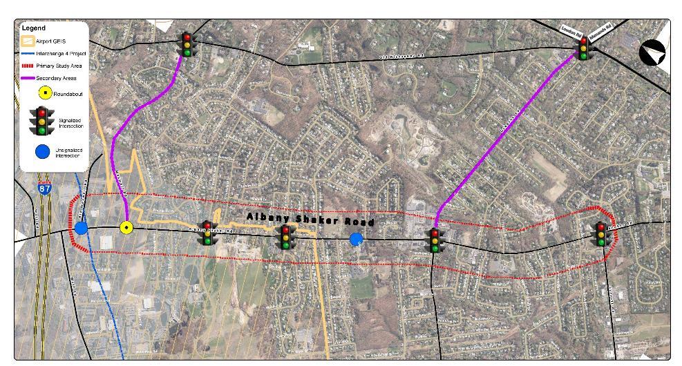
3 Study Area

4 Study Purpose Identify transportation and land-use recommendations that Mitigate the traffic concerns Enhance the character of the corridor Address safety and quality of life concerns Integrate with Town s Comprehensive Plan update Public outreach approach that develops a mutual understanding of issues and builds consensus


5 Livable Streets Provides transportation choices Safer streets for all modes Value communities and neighborhoods Promotes Community Interaction Enhance economic growth Quality of life Complete Streets are streets for everyone, no matter who they are or how they travel.
6 Existing Conditions Public Meeting # 1 Recap

7 Vacant Parcels in the Corridor

8 Land-use/Zoning Known development projects under construction or in planning Vacant parcels with probable development density based on zoning or discussions with property owners Exception: one parcel for density greater than underlying zoning based on landowner discussions and site s unique location Was conservative in that not all parcels would be expected to be developed within planning period


9 Public Meeting # 1 Recap Existing Public Build 2030 Mitigation Public
10 Concerns / Issues raised Traffic Congestion Safety: Speed Side street traffic The Crossings Town Park Pedestrian/Bicycle friendly Safety : Critical Locations Access to side streets/driveways


11 Consistent with Comprehensive Plan Issues that impact quality of life in the Town of Colonie Quality of Life Safety and security Traffic Congestion Strongly support following programs/initiatives Pedestrian accommodations Slower speeds Improvements in Town Parks
12 Concerns / Issues raised Traffic Congestion Safety: Speed Side street traffic The Crossings Town Park Pedestrian/Bicycle friendly Safety : Critical Locations Access to side streets/driveways

13 Traffic from New Development Traffic volumes in the corridor would increase by average of 5% based on Build-out conditions Similar growth pattern: from Albany Shaker Road to Old Niskayuna Road via Maxwell Road/Osborne Road Exit 4 connector, west of Wolf Road and increased capacity on I-87, will not increase traffic on Maxwell Road and the corridor east of Maxwell Road
14 Corridor Traffic Mostly limited to Osborne Road intersection Along the entire Corridor
15 Traffic from New Development Likely increase in traffic due to development will progress slowly over time and will not have immediate impact Based on the CDTC STEP Model 40% of the traffic is cutthrough
16 Hourly Traffic Variations Practical Capacity Threshold Albany Shaker Road Osborne Rd to Wolf Rd (Typical Weekday) Vehicles per Hour (VPH) Legend Traffic Existing 2016 WB EB :00 AM 1:00 AM 2:00 AM 3:00 AM 4:00 AM 5:00 AM 6:00 AM 7:00 AM 8:00 AM 9:00 AM 10:00 AM 11:00 AM 12:00 PM 1:00 PM 2:00 PM 3:00 PM 4:00 PM 5:00 PM 6:00 PM 7:00 PM 8:00 PM 9:00 PM 10:00 PM 11:00 PM

17 Impact from New Development Traffic will increase but will not have significant impact on traffic conditions Traffic will not alter the recommendations in the study
18 Concerns / Issues raised Traffic Congestion Safety: Speed Side street traffic The Crossings Town Park Pedestrian/Bicycle friendly Safety : Critical Locations Access to side streets/driveways
 High residential use-traffic conflict index (CDTC) leading to noise level, driveway movement, unsafe")
19 Safety: Speed Posted speed limit is 40 mph Average speed is 35 mph 85 th percentile speed is 45 mph Peak hour speeds: Near Shaker El 36/34 mph (AM/PM) Near Twilight Terrace 40/30 mph (AM/PM) High residential use-traffic conflict index (CDTC) leading to noise level, driveway movement, unsafe environment


20 Safety: Speed Mitigation Reduce speed limit to 30 or 35 mph Increased speed enforcement Driver feedback signs


21 Safety: Speed 30 MPH 40 MPH Higher the speed, reduction in cone of visibility Risk of serious injury increases dramatically above 30 mph Recommend speed reduction to mph NACTO Street Design Guidance


22 Safety: Speed Data shows that driver feedback signs are effective In Shelburne, Vermont, radar speed feedback signs showed a reduction in speed by 6 to 8 mph On US Route 9 in the Town of Malta, CDTC found that the driver feedback signs resulted in a 5 mph reduction in average speed Recommend installation of driver feedback signs
23 Concerns / Issues raised Traffic Congestion Safety: Speed Side street traffic The Crossings Town Park Pedestrian/Bicycle friendly Safety : Critical Locations Access to side streets/driveways

24 Side Street Traffic Consider traffic calming measures on alternate routes to discourage regional traffic from using local/neighborhood streets Street design Education Enforcement Locations to Consider: Campagna Drive/Marie Parkway Emerick Ln/Briarwood Road Danielwood Drive Loudon Parkway


25 Side Street Traffic Tighten street geometry to reduce travel speed, making is less desirable Increased enforcement on side streets like Marie Parkway Feasibility of additional traffic control signs/devices
26 Concerns / Issues raised Traffic Congestion Safety: Speed Side street traffic The Crossings Town Park Pedestrian/Bicycle friendly Safety : Critical Locations Access to side streets/driveways

27 The Crossings Access to The Crossings park Single access point Busier in good weather Exclusive pedestrian phase during peak hours add to delays Limited parking in the park


28 The Crossings Metro Park Rd Mitigation Access via Metro Park Road Improve and attract by better wayfinding Encourage and advertise this access Increase parking Secondary access and increased parking recommended Albany Shaker Rd
29 The Crossings Intersection Add leading left turn phase to signal only* Add crosswalk and pedestrian facilities to EB approach Add left turn lane Consider mini roundabout The Crossings Emerick Ln
30 The Crossings Signal Timing Changes August 2017 Lead left-turn for WB approach EB delay increases by 3 seconds Reduced queues westbound Observed increased queues eastbound Exclusive pedestrian phase Emerick Ln The Crossings * Based on average of 5 pedestrian calls per hour
31 The Crossings Mini Roundabout Pros Traffic calming Improved traffic flow Pedestrian facilities Cons Mini Roundabout not a viable option Roundabout will reduce vehicle gaps for those to turn left on side streets in the corridor ROW impacts Costs $ 500,000 1 million The Crossings Emerick Ln

32 The Crossings Left Turn Lanes Pros Improved traffic flow Cons If done within existing ROW, lose shoulders If widening, ROW impacts Pedestrian safety Costs $ 500,000 The Crossings Emerick Ln Widening for turn lanes to be considered in the future based on traffic conditions
33 Concerns / Issues raised Traffic Congestion Safety: Speed Side street traffic The Crossings Town Park Pedestrian/Bicycle friendly Safety : Critical Locations Access to side streets/driveways

34 Pedestrian/Bicycle Provide sidewalks on both sides of the road between The Crossings and Everett Road intersections Existing Pedestrian & Crosswalk Facility Recommended option Pros Improved pedestrian connections Pedestrian safety Character of the street Cons Tight ROW Acquire ROW at some locations Cost $1-2 million
35 Pedestrian/Bicycle Provide a dedicated path on one side of Albany Shaker that could accommodate bicycles Dedicated bike path not a viable option Pros Dedicated bike lane/path Bicycle safety Character of the street Complete streets Cons Acquire ROW on adjacent properties Cost implications ($ 3-5 million)

36 Pedestrian/Bicycle Provide/improve intersection crossing improvements at these locations: The Crossings/Emerick Lane Marie Parkway Shaker El Everett Road Osborne Road Provide Share the Road signs in locations with narrow shoulders Recommended option
37 Marie Parkway Add pedestrian accommodations Tighten radii and remove median

38 Marie Parkway Pros Improved pedestrian connection Reduced walking distance Improved circulation for emergency vehicles Cons Current signal does not support Upgrade signal to provide pedestrian pedestrian accommodations. accommodations is recommended Cost $ 500,000

39 Shaker El Add crosswalk to side street Improve pedestrian accommodations like Yield to Pedestrian sign Consider roundabout or signalization Shaker El Danielwood

40 Shaker El Mini Roundabout Heavy east-west traffic Low volumes on sidestreet Side street access will get difficult Limited Right-of-way School bus turning Cost $ 500,000 1 million Shaker El Danielwood Mini Roundabout not a viable option
41 Shaker El Pros Improved pedestrian connection Easier to turn left out of Shaker El Signalization will also slow down traffic more other modes friendly Cons Another signalized intersection will slow traffic in peak hour Cost $ 300,000 Signalization is recommended Shaker El Danielwood
42 Concerns / Issues raised Traffic Congestion Safety: Speed Side street traffic The Crossings Town Park Pedestrian/Bicycle friendly Safety : Critical Locations Access to side streets/driveways

43 Safety: Critical Locations Based on concentration of crashes and types the following priorities should be considered: Everett Road Intersection Osborne Road Intersection, particularly the westbound approach between Osborne and Tipton Maxwell Road Roundabout

44 Everett Road Road Diet Option Eliminate second WB thru lane Add EB left lane Pedestrian accommodations


45 Everett Road

46 Everett Road Pros Reduce crashes due to the merge Easier turning into driveways/side streets Pedestrian accommodations Cons Cost $ 200,000 Intersection Improvements recommended option ROW impacts
47 Osborne Road Signal timing changes Consider a roundabout Other geometric improvements to improve peak hour flow Consider reduction of turn radii to improve walkability Osborne Rd Osborne Rd
 C (27.7) Albany Shaker Rd WB L D (35.1) D (37.1) C (24.7) T F (211.6) F (254.7) E (72.9) R (TR) B (10.9) B (10.7) D (47.9) Osborne Rd NB L D (42.2) D (54.9) D (59.7) TR D (41.8) D (48.7) D (50.")
48 Osborne Road Signal Timing And WB through lane Intersection Existing LOS Osborne Rd Build LOS Osborne Rd WB thru turn lane LOS Albany Shaker Rd EB L D (40.8) D (40.7) C (35.5) TR C (27.9) C (33.2) C (27.7) Albany Shaker Rd WB L D (35.1) D (37.1) C (24.7) T F (211.6) F (254.7) E (72.9) R (TR) B (10.9) B (10.7) D (47.9) Osborne Rd NB L D (42.2) D (54.9) D (59.7) TR D (41.8) D (48.7) D (50.0) Osborne Rd SB L C (31.5) C (33.5) C (35.2) TR E (70.9) F (96.0) E (79.3) Overall F (87.8) F (106.5) D (51.8)
49 Osborne Road Signal Timing And SB right turn lane Intersection Existing LOS Osborne Rd Osborne Rd Build LOS Right turn lane LOS Albany Shaker Rd EB L D (40.8) D (40.7) C (32.0) TR C (27.9) C (33.2) C (26.5) Albany Shaker Rd WB L D (35.1) D (37.1) C (29.6) T F (211.6) F (254.7) F (181.6) R B (10.9) B (10.7) A (9.4) Osborne Rd NB L D (42.2) D (54.9) D (58.9) TR D (41.8) D (48.7) D (51.3) Osborne Rd SB L C (31.5) C (33.5) C (32.2) TR(T) E (70.9) F (96.0) D (52.8) (R) C (24.9) Overall F (87.8) F (106.5) E (76.1)
50 Osborne Road Signal Timing And WB or SB lane improvements Pros Reduce vehicle crashes Pedestrian accommodations Reduce in delays Osborne Rd Cons Additional lanes- not a feasible option ROW acquisition Pedestrian safety Improves traffic flow Cost $ 500,000 Osborne Rd
 Albany Shaker Rd WB L,TR D (44.5) Osborne Rd NB LTR C (24.")
51 Osborne Road Roundabout Pros Improved traffic flow Vehicle crash reduction Speed reduction Pedestrian safety Cons Bottleneck effect Private property acquisition Cost $2.5 million approximately Intersection Roundabout possibly a long term option Osborne Rd Osborne Rd LOS Albany Shaker Rd EB LTR B (12.8) Albany Shaker Rd WB L,TR D (44.5) Osborne Rd NB LTR C (24.4) Osborne Rd SB L,TR B (12.2) Overall C (26.1)

52 Access Management Better access management between Maxwell Rd and Wolf Rd, including consideration of a raised median in conjunction with roundabout improvements

53 Access Management Raised median recommended Example of raised median island
54 Maxwell Rd Roundabout Improved signage Evaluate EB thru lane capacity to eliminate merge Lane assignments Reevaluate design with current and emerging criteria Confirm potential impacts associated with Aviation Rd extension

55 Maxwell Rd Roundabout Pros Improved traffic flow Reduce crashes with proper signage Cons Cost Impact due to future development

56 Maxwell Rd Roundabout Conceptual Conceptual
57 Concerns / Issues raised Traffic Congestion Safety: Speed Side street traffic The Crossings Town Park Pedestrian/Bicycle friendly Safety : Critical Locations Access to side streets/driveways

58 Access to Side Streets/Driveways Center turn lane throughout the corridor (except the signalized intersections)
59 Access to Side Streets/Driveways Using shoulders for center-turn-lane WB Lane Center Turn Lane EB Lane PROS Facilitate access Reduce turn conflicts Decrease delays Existing condition with shoulders on either sidecons No shoulders Eliminates space for bicycles Increased speed and traffic No buffer between vehicles Shoulder WB Lane EB Lane and pedestrian Shoulder Cost $$$


60 Access to Side Streets/Driveways CONS No shoulders Eliminates space for goals bicycles Not Complete Street Less pleasant and safe to walk Not consistent with Study Center turn lane is not recommended at this time
61 Concerns / Issues raised Traffic Congestion Safety: Speed Side street traffic The Crossings Town Park Pedestrian/Bicycle friendly Safety : Critical Locations Access to side streets/driveways

62 Coordination with other Studies The Town is in the middle of update to the Comprehensive Plan and an update to the Airport Area GEIS Expected to be completed before completion of the Comprehensive Plan and the Airport Area GEIS It is expected that the Comprehensive Plan will either keep projected development densities at current levels or lower them through the Comp plan and future land use law changes. These changes should not influence the results of the ASR Study.

63 Schedule Summer: Develop and evaluate recommendations Fall: Confirm recommendations with Team November: Public Meeting # 2 January: Draft Report
64 Next Steps Consensus on transportation mitigation measures Compile public input and summarize information Present final recommendations to the Town and County Draft report- January 2018
 to 22333 3.")
65 Poll Everywhere: Live Audience Participation 1. Polling screen 2. Text ALBANYSHAKERRD to join; then text your answer(s) to Real time results!
66 Poll Everywhere Questions
67 THANK YOU for your feedback!

68 Questions
69 Your Opinion Let us know what your like or concerns are : albanyshakercolonie@cmellp.com OR Fill out a comment form

70 Thank You
Public Involvement Meeting Tuesday, June 13, Albany Shaker Road Corridor Study
 Public Involvement Meeting Tuesday, June 13, 2017 Albany Shaker Road Corridor Study Agenda / Meeting Outline 1. Introduce the project 2. Complete Streets 3. Share/confirm our findings 4. Your Opinion 5.
VT15 / Allen Martin Drive Intersection Scoping Study
 VT15 / Allen Martin Drive Intersection Scoping Study ALTERNATIVES PRESENTATION MEETING DECEMBER 19, 2016 Agenda Study Area Project Background Existing Conditions Identified Issues Proposed Alternatives
Public Information Centre
 WELCOME Public Information Centre Father Tobin Road Lougheed Middle School - Library Wednesday November 7, 2012 7:00 p.m.to 9:00 p.m. Please sign in Neighbourhood Traffic Calming Guide Background The City
BETHEL ROAD AND SEDGWICK ROAD CORRIDOR STUDY
 DRAFT PLAN City Council Meeting August 14, 2017 STUDY AREA Sedgwick Corridor State Route 160, principal arterial with Class 3 access management designation, commuter and freight route, connection to SR
Summary: Mercer County Princeton Avenue & Spruce Street Study January 2009
 Summary: Several recent studies have assessed potential development and redevelopment opportunities in the Mercer Crossing area of Trenton, Ewing, and Lawrence. This Princeton Avenue and Spruce Street
Town of Bethlehem. Planning Assessment. Bethlehem Town Board
 Town of Bethlehem US 9W Corridor Transportation Planning Assessment Presented e to: Bethlehem Town Board June 2009 Overview Study Background Route 9W Corridor Conditions and Improvements Selkirk Bypass
Public Information Meeting. Warren County Pathway Corridor Project September 27, 2018
 Public Information Meeting Warren County Pathway Corridor Project September 27, 2018 Why are we here? Introduce Study Hear concerns and Ideas Obtain input on preliminary Alternatives Previous Study (2008)
Arlington Public Schools New Elementary School at Thomas Jefferson Site Off-Site Transportation. Thomas Jefferson BLPC / PFRC Meeting July 27, 2016
 Arlington Public Schools New Elementary School at Thomas Jefferson Site Off-Site Transportation Thomas Jefferson BLPC / PFRC Meeting July 27, 2016 1.Review of Analysis 2.Key Transportation Issues 3.Recommendations
WELCOME Public Information Centre
 WELCOME Public Information Centre Fernforest Drive Brampton Soccer Centre Community Room #2 Tuesday January 19, 2016 6:30 p.m.to 9:00 p.m. Please sign in Neighbourhood Traffic Calming Guide Background
Edenbrook Hill Drive Traffic Calming Study
 WELCOME Public Information Centre Edenbrook Hill Drive Traffic Calming Study Fletchers Meadow Secondary School Wednesday January 20, 2016 6:30 p.m.to 9:00 p.m. Please sign in Neighbourhood Traffic Calming
TRANSPORTATION FACILITY PLANNING Waugh Chapel Road Maytime Drive to New Market Lane
 July 24, 2018 TRANSPORTATION FACILITY PLANNING Waugh Chapel Road Maytime Drive to New Market Lane DPWandYOU.com Making a difference, together Meeting Agenda Purpose of the project Overview of work conducted
Borough of Danville, PA Traffic Calming Program Guidelines
 Borough of Danville, PA Traffic Calming Program Guidelines Adopted by Borough Council on 1 INTRODUCTION Speeding Traffic is a major concern in the Borough of Danville because of its detrimental impacts
Colchester/Riverside/Barrett/ Mill Intersection Study. PAC Meeting #3 September 22, 2016
 Colchester/Riverside/Barrett/ Mill Intersection Study PAC Meeting #3 September 22, 2016 Tonight s Agenda Review Project Purpose and Need Describe short term and long improvements and changes since public
Simulation Analysis of Intersection Treatments for Cycle Tracks
 Abstract Simulation Analysis of Intersection Treatments for Cycle Tracks The increased use of cycle tracks also known as protected bike lanes has led to investigations of how to accommodate them at intersections.
Los Altos Hills Town Council - June 18, 2015 Palo Alto City Council June 22, AGENDA ITEM #2.B Presentation
 Los Altos Hills Town Council - June 18, 2015 Palo Alto City Council June 22, 2015 AGENDA ITEM #2.B Presentation Previous Presentations Los Altos Hills Town Council in May 2014 and February 2015 Palo Alto
El Camino Real Specific Plan. TAC/CAC Meeting #2 Aug 1, 2018
 El Camino Real Specific Plan TAC/CAC Meeting #2 Aug 1, 2018 Land Use Alternatives Goals and Tradeoffs Parks & open space Housing Retail & services Civic spaces Parking Community gathering spaces 3 Alternatives
North Avenue Corridor Study
 North Avenue Corridor Study Advisory Committee Meeting #6 July 1, 2014 Agenda Concept Revisions based on Advisory Committee feedback Review of New Concept Scoring & Costs Concept Discussion/Questions Voting:
CITY OF WEST LAKE HILLS. Forest View Neighborhood Traffic Calming Study
 CITY OF WEST LAKE HILLS 901 South Mopac Expressway Building V, Suite 220 Austin, Texas 78746 Texas P.E. Firm Registration No. F-929 Klotz Associates Final Report Submittal: March 20, 2015 Revised Final
Off-road Trails. Guidance
 Off-road Trails Off-road trails are shared use paths located on an independent alignment that provide two-way travel for people walking, bicycling, and other non-motorized users. Trails specifically along
Transportation Planning Division
 Transportation Planning Division Presentation Outline Study Tasks Recap of Previous Meeting Stakeholder Interviews Data Collection Design Principles Tool Box Recommendations Schedule Moving Forward North
MEMORANDUM. Charlotte Fleetwood, Transportation Planner
 MEMORANDUM Date: Updated August 22, 2017 To: Organization: Charlotte Fleetwood, Transportation Planner Boston Transportation Department From: Jason DeGray, P.E., PTOE, Regional Director of Engineering
5.0 Roadway System Plan
 Southwest Boise Transportation Study Page 16 5.0 Roadway System Plan The Roadway System Plan outlines roadway improvements in the Initial Study Area. It forecasts future deficiencies on the arterial system,
Balancing Operation & Safety for Motorized and Non-Motorized Traffic
 Balancing Operation & Safety for Motorized and Non-Motorized Traffic Brian Willham, PE, PTOE Iowa Director - MOVITE June 30, 2014 Learning Objectives: When & Why should we measure the performance of complete
J Street and Folsom Boulevard Lane Conversion Project (T ) Before and After Traffic Evaluation
 Before and After Traffic Evaluation") J Street and Folsom Boulevard Lane Conversion Project (T15125400) Before and After Traffic Evaluation Prepared by Transportation Division June 2014 Executive Summary On February 12, 2013, the City of Sacramento
J Street and Folsom Boulevard Lane Conversion Project (T15125400) Before and After Traffic Evaluation Prepared by Transportation Division June 2014 Executive Summary On February 12, 2013, the City of Sacramento
Boston Post Road Design Feasibility Study
 Boston Post Road Design Feasibility Study Prepared for the City of Rye Final Report July 18, 2007 Prepared by: Buckhurst Fish & Jacquemart (BFJ) 115 Fifth Avenue New York, NY 10003 www.bfjplanning.com
Princeton Avenue and Spruce Street Transportation and Site Access Enhancements Project
 Princeton Avenue and Spruce Street Transportation and Site Access Enhancements Project Mercer County Planning Division AECOM Transportation (formerly DMJM Harris) January 29, 2009 Agenda Project Status
Route 28 (South Orleans Road)/Route 39 (Harwich Road)/Quanset Road Intersection
/Route 39 (Harwich Road)/Quanset Road Intersection") TRAFFIC FEASIBILITY STUDY Route 28 (South Orleans Road)/Route 39 (Harwich Road)/Quanset Road Intersection Orleans, Massachusetts Prepared for: Town of Orleans Prepared by: Fay, Spofford & Thorndike, LLC
TRAFFIC FEASIBILITY STUDY Route 28 (South Orleans Road)/Route 39 (Harwich Road)/Quanset Road Intersection Orleans, Massachusetts Prepared for: Town of Orleans Prepared by: Fay, Spofford & Thorndike, LLC
INDUSTRIAL BUILDING 3009 HAWTHORNE ROAD CITY OF OTTAWA TRANSPORTATION OVERVIEW REVISED. Prepared for: Canada Inc.
 INDUSTRIAL BUILDING 3009 HAWTHORNE ROAD CITY OF OTTAWA TRANSPORTATION OVERVIEW REVISED Prepared for: 7849648 Canada Inc. Octiober 1, 2015 114-598 Overview_2.doc D. J. Halpenny & Associates Ltd. Consulting
TRAFFIC IMPACT STUDY And A TRAFFIC SIGNAL WARRANT ANALYSIS FOR A SENIOR LIVING AND APARTMENT DEVELOPMENT
 TRAFFIC IMPACT STUDY And A TRAFFIC SIGNAL WARRANT ANALYSIS FOR A SENIOR LIVING AND APARTMENT DEVELOPMENT DEERFIELD TOWNSHIP, WARREN COUNTY, OHIO Nantucket Circle and Montgomery Road () Prepared for: ODLE
Reference number /VP. Lafayette Downtown Congestion Study - Additional Traffic Analysis
 To James Hinkamp and Tony Coe, City of Lafayette Date January 19, 2017 Copies Reference number 243381/VP From Michael Iswalt and Vanessa Peers File reference 4-05 Subject Lafayette Downtown Congestion
Chapter 2: Standards for Access, Non-Motorized, and Transit
 Standards for Access, Non-Motorized, and Transit Chapter 2: Standards for Access, Non-Motorized, and Transit The Washtenaw County Access Management Plan was developed based on the analysis of existing
TRANSPORTATION ANALYSIS REPORT US Route 6 Huron, Erie County, Ohio
 TRANSPORTATION ANALYSIS REPORT US Route 6 Huron, Erie County, Ohio December 12, 2012 Prepared for: The City of Huron 417 Main Huron, OH 44839 Providing Practical Experience Technical Excellence and Client
REGIONAL BICYCLE AND PEDESTRIAN DESIGN GUIDELINES
 REGIONAL BICYCLE AND PEDESTRIAN DESIGN GUIDELINES November 16, 2011 Deb Humphreys North Central Texas Council of Governments Bicycle and Pedestrian Advisory Committee Snapshot of the Guide 1. Introduction
WISCONSIN AVENUE EXTENSION SECOND PUBLIC INFORMATION MEETING. March 28, 2017
 WISCONSIN AVENUE EXTENSION SECOND PUBLIC INFORMATION MEETING March 28, 2017 STUDY AREA N MEETING AGENDA Introductions Study Background Alternatives Studied Recommended Alternative Discussion STUDY BACKGROUND
C C C
 C-012-001 Thank you for your support for the creation of new public space and nonmotorized access between downtown and the waterfront through the Overlook Walk, the East-West Connections, and the Promenade.
Bridgewater Complete Streets Prioritization Plan and Pedestrian Safety Assessment
 Bridgewater Complete Streets Prioritization Plan and Pedestrian Safety Assessment Presented by Luciano Rabito Manager of Complete Streets Presented to Bridgewater, MA Wednesday, April 26, 2017 6:30 P.M.
CITY OF LOS ANGELES INTER-DEPARTMENTAL MEMORANDUM
 CITY OF LOS ANGELES INTER-DEPARTMENTAL MEMORANDUM Date: April 1, 219 To: Honorable City Council c/o City Clerk, Room 395, City Hall Attention: Honorable Mike Bonin, Chair, Transportation Committee From:
Welcome! San Jose Avenue Open House August 25, 2015
 Welcome! San Jose Avenue Open House August 25, 2015 Vision Zero The City and County of San Francisco adopted Vision Zero San Francisco Vision Zero High Injury Network as a policy in 2014, committing an
EXECUTIVE SUMMARY. Vision
 Vision Walking and bicycling in Salt Lake City will be safe, convenient, comfortable, and viable transportation options that connect people to places, foster recreational and economic development opportunities,
Omaha s Complete Streets Policy
 Omaha s Complete Streets Policy (Adopted August 2015) VISION To create great places and enhance our quality of life, the City of Omaha will provide safe, accessible streets for all users. Complete Streets
Complete Street Analysis of a Road Diet: Orange Grove Boulevard, Pasadena, CA
 Complete Street Analysis of a Road Diet: Orange Grove Boulevard, Pasadena, CA Aaron Elias, Bill Cisco Abstract As part of evaluating the feasibility of a road diet on Orange Grove Boulevard in Pasadena,
MEMORANDUM. DATE March 1, 2012 TO Town of Milton Mark Abbott, Seth Asante, and Efi Pagitsas Boston Region MPO Staff
 MEMORANDUM DATE March 1, 212 TO Town of Milton FROM RE Mark Abbott, Seth Asante, and Efi Pagitsas Boston Region MPO Staff FFY 211 Safety and Operations Analyses at Selected Boston Region MPO Intersections:
Southview Blvd & 3 rd Avenue Improvement Project. Public Open House December 4, to 7pm
 Southview Blvd & 3 rd Avenue Improvement Project Public Open House December 4, 2014 5 to 7pm Southview Blvd & 3 rd Avenue Public Information Meeting Agenda Presentation 5:30 to 6:15 pm Purpose of Project
Why Zone In on Speed Reduction?
 Learn it. Do it. Live it! SPEED REDUCTION IN THE ZONE Why Zone In on Speed Reduction? Speeding is a serious issue that plays a major role in the risk of serious injury and pedestrian fatality in a crash.
STILLWATER AVENUE CORRIDOR STUDY Old Town, Maine
 Draft Study STILLWATER AVENUE CORRIDOR STUDY Old Town, Maine SUBMITTED TO: BANGOR AREA COMPREHENSIVE TRANSPORTATION SYSTEM SUBMITTED BY: I MAY 23, 2017 DRAFT STILLWATER AVENUE STUDY FINAL REPORT Table
How to Develop a Pedestrian Safety Action Plan
 How to Develop a Pedestrian Safety Action Plan Course Introduction Presented by: Peter Eun FHWA RC Safety Engineer Ryan Snyder President, Ryan Snyder Associates, LLC Paul Zykofsky Director, Land Use and
City of Vallejo Traffic Calming Toolbox
 City of Vallejo Traffic Calming Toolbox June 1, 2013 Final Table of Contents Introduction... 1 Non-Physical Devices... 3 High-Visibility Crosswalk... 3 In Pavement Lighted Crosswalk... 4 Rapid Flashing
WELCOME. Stakeholder Involvement Group Meeting #2 Round Lake Public Works October 24, 2018
 WELCOME Stakeholder Involvement Group Meeting #2 Round Lake Public Works October 24, 2018 MEETING AGENDA 1. Welcome and Introductions 2. Study Progress Update 3. Problem Statement 4. Technical Analysis
Designing for Pedestrian Safety
 Designing for Pedestrian Safety Introduction to Pedestrian Safety Design and Planning Principles Presented by: Craig Allred FHWA Resource Center Technical Specialist and Michael Ronkin Owner, Designing
Public Works Committee Meeting Richard E. Mastrangelo Council Chamber November 20, 2017
 Public Works Committee Meeting Richard E. Mastrangelo Council Chamber November 20, 2017 Purpose of Meeting Why are we here? Project Recap/Updates Project Limits/Segments Road Diet Concept Lessons Learned
CHAPTER 3: Vision Statement and Goals
 Davidson Walks & Rolls: Active Transportation Master Plan CHAPTER 3 Contents: Overview Vision Statement Measurable Goals Public Outreach CHAPTER 3: Vision Statement and Goals Overview The vision statement
Proposed. City of Grand Junction Complete Streets Policy. Exhibit 10
 Proposed City of Grand Junction Complete Streets Policy Exhibit 10 1 City of Grand Junction Complete Streets Policy Vision: The Complete Streets Vision is to develop a safe, efficient, and reliable travel
Feasibility Study of Pedestrian Crossings Along Route 7, East of Cascades Parkway and West of Dranesville Road. October 3, 2017
 Feasibility Study of Pedestrian Crossings Along Route 7, East of Cascades Parkway and West of Dranesville Road October 3, 2017 Study Area (area within a ¼-mile radius of the study intersections) Route
North Avenue Corridor Study
 North Avenue Corridor Study Transportation, Energy and Utilities Committee September 10, 2014 Presentation Outline Project Initiation: Why North Avenue? Existing Conditions + Issues Vision + Goals Improvement
Bay to Bay Boulevard Complete Streets Project
 Bay to Bay Boulevard Complete Streets Project Dale Mabry Highway to Bayshore Boulevard February 08, 2018 Photo Source: Tampa Bay Times Alessandra Da Pra Meeting Format Introduction Resurfacing Information
6.4 RECOMMENDED IMPROVEMENTS
 6.4 RECOMMENDED IMPROVEMENTS 6.4.1 Williston Road Recommendations While all alternatives would be an improvement over existing conditions, Alternative 3B is recommended over the others because it provides
Highway 49, Highway 351 and Highway 91 Improvements Feasibility Study Craighead County
 Highway 49, Highway 351 and Highway 91 Improvements Feasibility Study Craighead County Executive Summary March 2015 Highway 49, Highway 351 and Highway 91 Improvements Feasibility Study Craighead County
2014/2015 BIKE ROUTE PLAN 83 AVENUE PROTECTED BIKE LANE
 About the Project 2014/2015 BIKE ROUTE PLAN The City of Edmonton is planning a major bike route on the south side of Edmonton. This bike route is one part of a plan to provide citizens with transportation
US 41 COMPLETE STREETS CORRIDOR PLANNING STUDY from University Parkway to Whitfield Avenue
 41 US 41 COMPLETE STREETS CORRIDOR PLANNING STUDY from University Parkway to Whitfield Avenue EXECUTIVE SUMMARY DRAFT FEBRUARY 2019 Project Overview The US 41 Complete Streets Corridor Planning Study,
4. ENVIRONMENTAL IMPACT ANALYSIS 9. TRANSPORTATION AND TRAFFIC
 4. ENVIRONMENTAL IMPACT ANALYSIS 9. TRANSPORTATION AND TRAFFIC 4.9.1 INTRODUCTION The following section addresses the Proposed Project s impact on transportation and traffic based on the Traffic Study
FAIRFIELD INN & SUITES HOTEL 135 THAD JOHNSON PRIVATE OTTAWA TRANSPORTATION BRIEF. Prepared for:
 FAIRFIELD INN & SUITES HOTEL 135 THAD JOHNSON PRIVATE OTTAWA TRANSPORTATION BRIEF Prepared for: Bona Building & Management Co. Ltd. Place Vanier, 333 North River Road Vanier, Ontario K1L 8B9 August 12,
Chapter 4 Traffic Analysis
 Chapter 4 Traffic Analysis PURPOSE The traffic analysis component of the K-68 Corridor Management Plan incorporates information on the existing transportation network, such as traffic volumes and intersection
Draft North Industrial Area-Wide Traffic Plan
 Summary of North Industrial and Hudson Bay Industrial Recommended Improvements Table 1. Summary of s Item Location 1 2 3 4 5 6 7 8 9 10 11 12 Millar Ave north of 51st St Super 8 Motel back lane 400 Block
North Avenue Corridor Study
 North Avenue Corridor Study City Council October 6, 2014 Presentation Outline Project Initiation & Process Corridor Conditions & Issues Vision & Goals Concept Development - Development/Evaluation Implementation
Southbend to Prima Vista. October 30, Floresta Corridor Master Plan
 Application of a Complete Street initiative and how it might function operationally 8 8 Southbend to Prima Vista October 30, 2017 Presentation Agenda 2 Perspective and History Traffic projections, Levels
Tonight is for you. Learn everything you can. Share all your ideas.
 Strathcona Neighbourhood Renewal Draft Concept Design Tonight is for you. Learn everything you can. Share all your ideas. What is Neighbourhood Renewal? Creating a design with you for your neighbourhood.
Executive Summary Route 30 Corridor Master Plan
 Route Corridor Master Plan Project Overview The Route Corridor Master Plan is a coordinated multimodal transportation and land use plan for the entire stretch of Route through East Whiteland Township,
INDUSTRIAL BUILDING 1660 COMSTOCK ROAD CITY OF OTTAWA TRANSPORTATION OVERVIEW. Prepared for:
 INDUSTRIAL BUILDING 1660 COMSTOCK ROAD CITY OF OTTAWA TRANSPORTATION OVERVIEW Prepared for: Simluc Contractors Limited 2550 Blackwell Street, Ottawa K1B 5R1 October 18, 2013 113-584 Overview_1.doc D. J.
Chapter V Transportation Concept Alternatives
 Chapter V Transportation Concept Alternatives Three (3) fundamentally different approaches to meeting vehicular travel needs in the corridor were considered. One approach is to leave the road as it is
Traffic Impact Study WestBranch Residential Development Davidson, NC March 2016
 Traffic Impact Study WestBranch Residential Development Davidson, NC March 216 TRAFFIC IMPACT STUDY FOR THE WestBranch Residential Development LOCATED IN DAVIDSON, NC Prepared For: Lennar Carolinas, LLC
Broad Street Bicycle Boulevard Design Guidelines
 Broad Street Bicycle Boulevard Design Guidelines Building from the strategies introduced in the 2013 Bicycle Transportation Plan and community input received thus far, City Transportation Staff have identified
Henderson Avenue Mixed-Use Development
 Zoning Case: Z145-3 Traffic Impact Analysis Henderson Avenue Mixed-Use Development Dallas, TX October 26 th, 216 Kimley-Horn and Associates, Inc. Dallas, Texas Project #644827 Registered Firm F-928 Traffic
BD RESOLUTION NO RESOLUTION ADOPTING THE VISION ZERO RAMP INTERSECTION STUDY PHASE 1
 BD00 RESOLUTION NO. - RESOLUTION ADOPTING THE VISION ZERO RAMP INTERSECTION STUDY PHASE [NTIP PLANNING] FINAL REPORT WHEREAS, The Vision Zero Ramp Intersection Study Phase was recommended by Commissioner
Giles Run Connector Road
 Giles Run Connector Road Laurel Hill Adaptive Reuse Area to Laurel Crest Drive South County Federation Meeting June 14, 2016 History Connector road included in the Laurel Hill Comprehensive Plan amendment
Meeting Summary Public Information Meeting #1 Warren County Pathway Corridor Project September 27, 2018
 Meeting Summary Public Information Meeting #1 Warren County Pathway Corridor Project September 27, 2018 The first public information meeting for the Warren County Pathway Corridor Project was held on Thursday,
City of Moorhead Committee of the Whole Meeting
 City of Moorhead Committee of the Whole Meeting Corridor Study Limits Center Avenue (Red River to 8th Street) TH 10 (Red River to TH 336) TH 75 (20th Ave S to Main Avenue) 2 Study Need: Project Overview
City of Wilsonville 5 th Street to Kinsman Road Extension Project
 City of Wilsonville 5 th Street to Kinsman Road Walking Tour & Neighborhood Workshop Summary Report Public Outreach Overview On July 18 th, 2017, the City of Wilsonville hosted a neighborhood walking tour
54 th Avenue North Complete Streets Concept Plan
 54 th Avenue North Complete Streets Concept Plan June 2018 TABLE OF CONTENTS Introduction and Purpose...1 Existing Conditions...5 Stakeholder and Public Outreach...15 Preferred Options West Segment...19
City of Seattle Edward B. Murray, Mayor
 City of Seattle Edward B. Murray, Mayor Department of Transportation Scott Kubly, Director Eastlake Community Council 117 E Louisa St. #1 Seattle, WA 98102-3278 January 28, 2016 RE: Roosevelt to Downtown
to the Public Information Centre for the Downtown Traffic Study
 to the Public Information Centre for the Downtown Traffic Study City of Sault Ste. Marie July 25, 2018 Purpose of Study Determine if changes to one-way corridors can enhance downtown s character and spaces
Mineral Avenue Corridor Assessment. ITE 2017 Western District Annual Meeting San Diego, CA June 21 st
 Mineral Avenue Corridor Assessment ITE 2017 Western District Annual Meeting San Diego, CA June 21 st Biography - Aaron Heumann, PE, PTOE Currently City of Littleton Transportation Engineering Manager 24
Ottawa Beach Road Study
 Ottawa Beach Road Study Prepared For: Park Township September 30, 2014 Project No. G140303 OTTAWA BEACH ROAD STUDY PREPARED FOR: PARK TOWNSHIP SEPTEMBER 30, 2014 PROJECT NO. G140303 TABLE OF CONTENTS 1.0
Street / Bob Billings Parkway Lawrence, Kansas CFS Project No
 Drive Improvements 6 th Street to 15 th Street / Bob Billings Parkway Lawrence, Kansas 6644 CFS Project No. 15-56 Traffic Impact Study July 15, 15 Prepared for: City of Lawrence Public Works Department
Vision: Traditional hamlet with an attractive business/pedestrian friendly main street connected to adjacent walkable neighborhoods
 N D. Focus Area II Vision: Traditional hamlet with an attractive business/pedestrian friendly main street connected to adjacent walkable neighborhoods Transit Road Focus Area II is located in the Hamlet
Prince George s County plans, policies, and projects
 Prince George s County plans, policies, and projects Over 250 projects for trails, bikeways, designated bike lanes and sidewalk construction Trail projects that improve access to Metro Sidewalk and trail
Community Task Force July 25, 2017
 Community Task Force July 25, 2017 Welcome and Introductions Project Partners Regional Transportation District (RTD) Colorado Department of Transportation (CDOT) Denver Regional Council of Governments
Traffic Impact Analysis Chatham County Grocery Chatham County, NC
 Chatham County Grocery Chatham County, NC TABLE OF CONTENTS 1. INTRODUCTION... 1 1.1. Location and Study Area... 1 1.2. Proposed Land Use and Access... 2 1.3. Adjacent Land Uses... 2 1.4. Existing ways...
Modern Roundabouts. BY : Mark T. Johnson, P.E. An Informational Presentation Prepared For:
 Modern Roundabouts An Informational Presentation Prepared For: Transportation Research Board Roundabout Conference Vail, CO May 2005 Roundabout implementation in constrained urban environment - achieving
CONTENTS EXECUTIVE SUMMARY 1
 CONTENTS CHAPTER PAGE EXECUTIVE SUMMARY 1 1 ISSUES AND PURPOSE OF THE ANALYSIS 2 1.1 Background 2 1.2 Analysis Area 2 1.3 Issues and Observations 3 1.4 Project and Public Meetings 3 2 LIST OF PREFERRED
Northbound San Jose Avenue & I-280 Off-Ramp Road Diet Pilot Project
 Project Overview Fed by a two-lane Interstate-280 (I-280) off-ramp, high vehicular volumes and speeds are longstanding issues along San Jose Avenue. Residents in the surrounding neighborhoods have expressed
Blair/Williamson Intersection Expressed Needs
 Blair/Williamson Intersection Expressed Needs NORTH Blair Street is a barrier for pedestrians and bicycles Relocate Capitol City Trail crossing from Blair Street and John Nolen Drive intersection to Williamson
Caltrans Sloat Boulevard Pedestrian Safety Project Response to Community Questions, Comments & Concerns
 Caltrans Sloat Boulevard Pedestrian Safety Project Response to Community Questions, Comments & Concerns Revised: May 10, 2016 The California Department of Transportation (Caltrans) is planning various
ORANGE COUNTY PUBLIC WORKS TRAFFIC INVESTIGATIONS
 ORANGE COUNTY PUBLIC WORKS TRAFFIC INVESTIGATIONS STAFF REPORT OF: January 6, 2019 SUPERVISORIAL DISTRICT: 5 SUBJECT: LOCATION: INVESTIGATOR: O Neill Drive at Roanoke Drive; Ladera Ranch; TB 922-E6 Clever
Project Goals and Objectives
 Project Goals and Objectives Goal 1: Goal 2: Goal 3: Transform Coast Highway into a Complete Street that accommodates all roadway users (pedestrians, bicyclists, and autos) Objectives: Improve the pedestrian
AGENDA REPORT. Issue: Discussion of potential improvements on Barnwell Road at Niblick Drive
 AGENDA REPORT To: From: By: Honorable Mayor and City Council Members Warren Hutmacher, City Manager Tom Black, Public Works Director Date: March 23, 2016 Agenda: March 28, 2016 WORK SESSION AGENDA: Barnwell
Traffic Impact Analysis Walton Acres at Riverwood Athletic Club Clayton, NC
 Traffic Impact Analysis Walton Acres at Riverwood Athletic Club Clayton, NC 1. TABLE OF CONTENTS INTRODUCTION...1 1.1. Site Location and Study Area...1 1.2. Proposed Land Use and Site Access...2 1.3.
Roundabouts are good for business
 Roundabouts are good for business What is a roundabout Rules 0f Roundabouts 1. Slow down when approaching a roundabout 2. Yield to vehicles in the roundabout 3. When clear, proceed right into the roundabout
Safe Streets. City of Lake Forest Park. March 21, 2017
 Safe Streets City of Lake Forest Park March 21, 2017 1 01 WELCOME 2 Agenda WELCOME WHAT IS THIS PROJECT? CONTEXT DRAFT CITYWIDE PROJECTS EXERCISE INTRODUCTION 3 02 WHAT IS THIS PROJECT? 4 WHAT IS THIS
Truck Climbing Lane Traffic Justification Report
 ROUTE 7 (HARRY BYRD HIGHWAY) WESTBOUND FROM WEST MARKET STREET TO ROUTE 9 (CHARLES TOWN PIKE) Truck Climbing Lane Traffic Justification Report Project No. 6007-053-133, P 101 Ι UPC No. 58599 Prepared by:
Central Avenue Bikeway Traffic and Safety Impact Assessment
 FEBRUARY 2018 Lead Agency: San Diego Association of Governments (SANDAG) 401 B Street, Suite 800 San Diego, CA 92101 Contact: Chris Carterette, AICP, Project Manager 619.699.7319 chris.carterette@sandag.org