Bicycle/Pedestrian Subcommittee. Tuesday, January 10, :00 pm 6:00 pm Large Conference Room, City Hall Dover, DE AGENDA
|
|
|
- Ella Lloyd
- 5 years ago
- Views:
Transcription

1 Bicycle/Pedestrian Subcommittee Tuesday, January 10, :00 pm 6:00 pm Large Conference Room, City Hall Dover, DE AGENDA Welcome Approval of Agenda Approval of Meeting Minutes College / University Partnerships DelDOT s Bicycle Policy Plan Old Business Items: o Capital School District Update o Restoring Central Dover Bike Rack Grant Update o Senator Bikeway o Bike Friendly Community o Walk Friendly Community Announcements Adjournment


2 Statewide Bicycle Policy Plan Blueprint for a bicycle friendly Delaware
 DEDO/Department of Tourism Department of Public Health Office")


3 Stakeholders Delaware Department of Transportation (Planning, Traffic, Project Development, Subdivisions) DEDO/Department of Tourism Department of Public Health Office of Highway Safety Dover/Kent County MPO & WILMAPCO City of Wilmington New Castle, Kent and Sussex County Planning Delaware State Police DNREC Department of Health and Social Services Delaware Bicycle Council Bicycle Groups (White Clay Bike Club & Sussex Cyclists) Greenway and Trails Delaware Greenways DART Department of Motor Vehicles Council on Transportation Public
4 Key Points Revise previous bike plan from Safety continues to be a factor of active transportation investment. Update of Project Development process; Department policies, procedures and manuals would be updated, resulting in constructing high quality bicycle facilities. Coordination of current efforts. This is the development of a policy plan and not a project identification plan. Project requests to DelDOT should come from the MPO s, municipalities or other formal sponsors.
5 Goals Develop a policy oriented master plan that will improve Delaware s bicycle friendliness by: Integrating broad goals into a unified strategic plan. Identifying and promoting the many efforts already underway. Ensuring that progress toward a more bicycle friendly state is maintained. Ensuring that all of the Department s efforts make bicycling safer, more comfortable, and more convenient.
6 Goals Stakeholders clearly understand how to get a project from idea to reality. Clear, effective processes for project identification, prioritization, implementation. Revised design manual. Strengthened cross department relationships and processes within DelDOT. Coordinated, complementary efforts among all stakeholders (inside and outside DelDOT).
7 Work Plan December 7, 2016 Introduced working group members, presented the goals and timeline. January 18, 2017 First working group meeting (Future working group meetings will occur on odd numbered months). Full project introduction; establish Vision/Goals. Outreach and promote bicycle policy plan for upcoming four (4) public meetings. February 2017 Provide update to the Delaware Bicycle Council. Preparation for public meetings. March 2017 Review public input; discuss and refine Vision/Goals. April 2017 Provide update to the Delaware Bicycle Council; finalize Vision/Goals. May 2017 Review existing conditions; review/categorize items. Beyond and through 2017 Public awareness (web, social media, traditional media, partners); develop recommendations/get feedback; develop implementation plan; develop/present Final Plan.
8 Public Workshops February 22, 2017 Sussex County; tentatively scheduled at the Georgetown Public Library, 4:00 p.m. 7:00 p.m. February 27, 2017 New Castle County; tentatively scheduled at the Middletown High School, 4:00 p.m. 7:00 p.m. February 28, 2017 Kent County; tentatively scheduled at the Dover Public Library, 4:00 p.m. 7:00 p.m. March 1, 2017 New Castle County; tentatively scheduled at the Wilmington Public Library, 4:00 p.m. 7:00 p.m.
9 Page 1 of 38 Last updated Print This Page Community Profile This section is intended to provide applicants with a chance to describe their communities. Having an understanding of the geographic, demographic, and economic make up of the community can help explain the challenges and opportunities that the community faces when planning for walking. Contact Information Name of Community: Mayor or Top Official: Mayor's Phone: Community Contact Name: Position/Employer: Contact Address: City of Dover Mayor Robin Christiansen James Hutchison Bicycle/Pedestrian Subcommi PO Box 475 Address (line 2): City: State: Dover Delaware Zip code: Phone/Fax: Web site: hutchisonj@studiojaed.com Pedestrian Coordinator & Government Staff List your official pedestrian coordinator or pedestrian issues contact person on government staff, and identify his/her department.
10 Page 2 of 38 Contact Person: Contact Person Dept: Carolyn Courtney Parks & Recreation How many hours are spent per year in this capacity? 500 Is this person also the bicycle coordinator? No List all other government staff or contractors whose primary duties are devoted to walkability and pedestrian safety issues: Ann Marie Townshend, Director Planning, Community Services, and Parks & Recreation Eddie Diaz, Planning, City of Dover Bill Cook, Planning, City of Dover Sarah Coakley, State of Delaware Do you have a Pedestrian Advisory Committee, Ped/Bike Council or other venue for citizen input? No If yes, please provide the name of the Chair and their contact information: Bicycle and Pedestrian Subcommittee of the Safety Transportation and Advisory Committee (SA&T). SA&T Chair: James Hosfelt - hosdover@msn.com B/P Subcomm Chair: James Hutchison - hutchisonj@studiojaed.com Do you have an independent pedestrian advocacy organization? No If yes, please provide the name and contact information: Has your mayor signed the International Charter for Walking or a similar pledge to improve the conditions for walking in your community? No If yes, please provide details: Although the Mayor and Dover City Council have not yet signed off on the Charter, in November 2016 the Bicycle and Pedestrian Subcommittee reviewed the document and recommended its adoption. Council is now set to review and approve the Charter in January Community Profile
11 Page 3 of 38 Population: Area of municipality: Population Density: Park Land: Age Distribution: [?] under 20: age 20 64: age 65 84: 0ver 85: Last updated Status of Walking This assessment tool seeks to learn how much people are walking and how safe they are when they are doing so. Therefore, the outcomes that are most significant for the purposes of this tool are the numbers of walkers and the number of pedestrian crashes. Walk Friendly Communities is looking for communities that have created environments in which many people walk and pedestrian crash rates are low, or those communities that are making significant progress towards those ends. These two questions focus on these specific outcomes, while other questions in this survey address what measures are used by communities to facilitate walking and improve safety. Question 1 According to the 2000 Census, what percentage of residents used the following modes for their commute to work? Walking: Bicycling: Public transit: Single-occupant vehicles:
12 Page 4 of 38 Carpool: 13 Please also provide the latest walking percentage of commuting to work from the 3-year estimates of the American Community Survey: Walking : Walking : Public transit : Public transit : If your community conducts its own travel counts, please include a link, attachment or description of those count results: Web Link: Current travel count file: Comprehensive Plan count tables.pdf File Upload: Browse... Count Results Description: Local travel counts are conducted by the Delaware Department of Transportation, the Dover/Kent County Metropolitan Planning Organization, and the Delaware Transit Corporation. They generally cover both the City of Dover and surrounding Kent County. The latest data available was updated for the Dover 2008 Comprehensive Plan, and spans the years 1999 to Some significant results from the travel counts: Total annual vehicle miles traveled in Kent County increased from about 3,750 million in 1999 to about 4,600 million in 2006, an increase of 23%. Annual average daily traffic counts at the Dover Downs counting station in Dover showed a 15.42% increase in traffic between 2004 and 2006 on that portion of US Route 13, the city s busiest arterial road. Meanwhile, the Delaware Transit Corporation saw a 22% increase in passenger trips in its South District between 2002 and 2007, a rise from 308,716 trips to 376,223 trips. Question 2 How many pedestrian/motor vehicle crashes were reported in each of the last five years; and how many of these crashes resulted in injuries and fatalities? Number of Pedestrian Motor Vehicle Crashes 2014: Number of Pedestrian Motor Vehicle Crashes 2013: Number of Pedestrian Motor Vehicle Crashes 2012: Number of Pedestrian Motor Vehicle Crashes 2011:
13 Page 5 of 38 Number of Pedestrian Motor Vehicle Crashes 2010: Number of Pedestrian Injuries 2014: Number of Pedestrian Injuries 2013: Number of Pedestrian Injuries 2012: Number of Pedestrian Injuries 2011: Number of Pedestrian Injuries 2010: Number of Pedestrian Fatalities 2014: Number of Pedestrian Fatalities 2013: Number of Pedestrian Fatalities 2012: Number of Pedestrian Fatalities 2011: Number of Pedestrian Fatalities 2010: Question 3 What long-term trends in walking volumes and pedestrian/motor vehicle crashes has your community observed? The number of people in Dover who walk to work has fluctuated by less than 350 people between 2006 and The number peaked between 2010 and 2012, when about 722 people, or 5.2% of the city s commuters, walked to work. This number of walking commuters had not been seen since 2000, when 724 people, or 4.9% of the city s population at the time, walked to work. The most recent figures indicate that about 4.1%, or 640 people, walk to work today. These figures are not as good as the peak years, but better than the city's lowest point in 2008 when 449 people, about 2.7% of the population, walked to work. Motor vehicle crashes involving pedestrians have increased steadily between 2010 and The increase might be due to a population increase brought on by residential development between 2010 and Trends established between 2002 and 2006 might have continued while pedestrian commutes did not. Last updated Planning Pedestrian issues are addressed at many different levels of planning, ranging from neighborhood plans to city, county, state, and federal policies and plans. A comprehensive pedestrian plan should address all five Es (education, encouragement, enforcement, engineering and evaluation) along with public involvement. With
14 Page 6 of 38 thorough planning, a community can become proactive rather than reactive in addressing issues of pedestrian accessibility, safety, and aesthetics. Planning involves soliciting public input, collecting information about current and future conditions, and considering what policies, plans, programs and resources a municipality will require to meet your community's needs. Question 1 Has your community adopted a pedestrian plan or pedestrian safety action plan? Please provide a link or attachment of the plan. Link to action plan: Current action plan on file: Dover Pedestrian Plan.pdf Action plan file upload: Browse... What year was the plan adopted: 2015 How does this plan interact with or relate to your other planning documents? The City's updated Pedestrian Plan, as well as its updated Bicycle Plan, is a reference and guide for planning in Dover. City officials already are fulfilling some of the plan's goals and recommendations. What performance indicators or other techniques does your community use to monitor completion? The Bicycle and Pedestrian Subcommittee keeps track of specific capital improvements proposed by the Pedestrian Plan as they are completed. Currently, there are no performance indicators being tracked to measure progress toward overall plan goals. Does your community's pedestrian plan or other adopted plan or policy establish a target mode share for walking? No If so, what is the target walking share? Does the plan have a safety goal (such as the reduction in pedestrian crashes)? No If yes, what is the target crash reduction? Does the plan include any other benchmarks or performance indicators? If so, please describe:
15 Page 7 of 38 Safety is an implied goal throughout the Pedestrian Plan. What elements of the plan are complete? (Indicate what percent of the plan is complete, if possible.) The updated plan is too new for most of the proposed facilities to have finished construction, but there has been some progress. Some sidewalk gaps have been filled on U.S. Route 13 between Martin Luther King Jr. Boulevard and White Oak Road, between Townsend Boulevard and Leipsic Road, and between the Dover Mall and Denney's Road. A sidewalk along West Street between North Street and the Dover Transit Center, which runs between the heart of downtown Dover and its outskirts, is in design. Last summer, the city built a multiuse path in Mallard Pond Park. The path connects the park with Fox Hall West (Greenway Neighborhood) to Route 8. A trail extension is in design for Schutte Park. Staff is reviewing funding options to illuminate the pathway with bollard lighting. How are pedestrian issues captured in other plans (e.g. the comprehensive plan, Transportation Improvement Program, etc.)? Pedestrian neeeds are addressed in Dover's Comprehensive Plan, as well as the Dover/Kent County MPO's Metropolitan Transportation Plan. The MPO's plan recommends different levels of investment in different geographic areas under the MPO's purview according to state-level strategies for investment that designate growth areas throughout Delaware; the greatest improvement in pedestrian facilities is called for in the highest level growth areas. Question 2 Has your community adopted an ADA Transition Plan for the public right of way? If so, please provide a link or attachment of the plan. Link to action plan: Current action plan file: Dover ADA Transition Plan 2004.pdf Action plan file upload: Browse... If yes, what year was it adopted? 2004 Has the ADA Transition Plan been updated? No If yes, what year? Does the ADA Transition Plan address curb ramps and sidewalks? No Explain:
16 Page 8 of 38 The ADA Transition Plan specifies that the introduction of curb cuts for wheelchair accessibility is to be achieved through the City's annual street improvement program. The plan also identifies 55 locations where utility poles reduced sidewalk width to less than 36 inches, obstructing the way for wheelchair users. The Electric Department implemented a program to relocate these poles. Does the ADA Transition Plan address street crossings and signals? No Explain: The ADA Transition Plan makes no mention of efforts to be taken to improve street crossings, i.e. audible crossing signals. Who is responsible for the implementation of the ADA Transition Plan? The City Manager, serving as the ADA C Is your transition plan being implemented? No Explain: The 2004 ADA Transition Plan has been fully implemented. The plan contained appropriations for ADA projects through fiscal year 2009, and those projects were funded and completed. Since its implementation, additional projects could doubtlessly be identified, but the transition plan will need to be updated or replaced in order to set an agenda for these projects. How is the ADA Transition Plan work funded? The ADA transition work was funded mostly by the city s General Fund and Community Development Block Grant funding. Additional funding came from the city s Electric Fund and the city s Parks and Recreation Department when projects impacted operations in those areas. Two examples are the construction of sidewalks and curb cuts in a park, or when a sidewalk needed to have an electric pole relocated in order meet width requirements for walkability. There are state roads in most communities. Has your state DOT adopted an ADA Transition Plan? Is the state DOT transition plan being implemented? No Explain: DelDOT adopted their first ADA Transition Plan in May However, in July 2015 DelDOT was informed by the FHWA that all new ADA Transition Plans provided by Departments of Transportation nationwide would require approval by the FHWA in order to meet full compliance with Title VI of the Civil Rights Act of 1964 and be eligible for federal funding. The 2014 Plan could not be approved because it did not provide an adequate schedule of remediation for the noncompliant features identified in the plan.
17 Page 9 of 38 Starting in early 2016, DelDOT worked to write an updated ADA Transition Plan that re-evaluated the inventory of features to be remediated and devised a detailed schedule for remediation. The updated plan is soon to be adopted. Implementation work has continued unabated during the update process. Since 2012, over 2,400 curb ramps have been constructed or reconstructed to meet ADA compliance within the state. 156 bus stops have similarly been reconstructed. DelDOT has created a Pedestrian Access Route program funded at $3 million annually to fill in gaps in its pedestrian system and ensure the fills are ADA compliant. Finally, designated ADA Civil Rights staff at the department has increased from one individual in 2012 to four in Question 3 Has your community adopted a Complete Streets policy or ordinance? Question 4 Please briefly describe how public input is used in the municipality's planning process. Mention the role that citizen participation, advisory board review, and/or the municipality's pedestrian/bicycle advisory council play in the process. How do you assure that individuals with disabilities are included in the public input process? Public input is embedded in the process for municipal projects. Public workshops often are offered for larger projects. If a project needs Dover City Council approval, or is discussed at a council meeting, committee meeting, or Dover Planning Commission meeting, these events are open to the public and advertised. Dover s primary planning documents (the 2008 Comprehensive Plan, Restoring Central Dover, the Bicycle Plan and Pedestrian Plan, etc.) all had a series of public workshops at which the public could participate in map exercises, surveys, and facilitated discussion. In addition, a steering committee comprised of local residents, community leaders, elected officials, and representatives from local institutions oversaw the Restoring Central Dover plan. The Bicycle and Pedestrian Subcommittee directly oversaw the updated Bicycle Plan and Pedestrian Plan. Public workshops are held for specific projects that the plans recommend to collect feedback before they are implemented. For instance, DelDOT and the City of Dover who are jointly working on a project called the Senator Bikeway have hosted a series of workshops showcasing the design recommended in the Bicycle Plan. More workshops are to come as phases of the project are ready to advertise. Provide any relevant links or attachments that indicate the formal and informal public participation and advocacy efforts in your community (i.e., a link to the pedestrian and bicycle advisory board website, if it exists, or documented guidelines for public participation in the planning process). Website link: Current participation file: Planning Commission public notice instructions.pdf Please briefly describe the role that citizen participation, advisory board review, and/or the municipality's pedestrian/bicycle advisory council play in the process of reviewing ongoing projects and development. Development projects in the city have a specific process to notify the public of the project, and allow people to come to Planning Commission meetings to comment on them. Public Notice is distributed by postal mail to neighboring property owners, posted in one of three local newspapers, and posted as a physical sign on the property being developed. The
18 Page 10 of 38 planning commissioners are typically very responsive to citizen concerns about development, including pedestrian concerns. For instance, one recent development project proposing a new grocery store within walking distance of several neighborhoods was denied a request to waive code-mandated sidewalk by the Commission due to neighbor concerns about safety on the routes to the store. The Bicycle and Pedestrian Subcommittee does not comment directly on development projects. However, city planning staff supporting the Subcommittee also supports the Planning Commission, and ensures the Subcommittee s priorities are represented when reviewing development projects. Please briefly describe how you assure that specific populations (like individuals with disabilities or low incomes) are included in the public input process. A community partnership lead by NCALL, Inc. formed and developed the Restoring Central Dover Plan. The Plan represents our community s vision for restoring the vitality of Central Dover and lists recommendations for implementation. Resident input and priorities have been derived from a community survey, meetings, events, activities, and community outreach. The Plan offers a multitude of strategies for a Strong Community, Positive Development, and an Integrated Public Realm and Infrastructure. Targeting those living in areas of high crime, lower income areas and found to be disadvantaged, the plan is intended to assist our citizens in these areas reach an improved quality of life. Central Dover is composed of a number of distinct residential areas clustered around the historic Loockerman Street commercial corridor. The Plan Area is made up of 75 blocks which is roughly 393 acres in size. Some challenges include crime and the perception of safety, the socioeconomic conditions of residents, and major vacancies among land parcels and buildings. Nevertheless, the area possesses many assets upon which we can center our revitalization work. Please briefly describe how your community works with coalitions, advocates, and other departments and agencies to ensure that pedestrians are considered in all projects and documents. Major pedestrian planning efforts are typically inter-agency and inter-departmental. For instance, the Pedestrian Plan was a joint effort between the City of Dover, the Dover-Kent County MPO, and DelDOT. Sidewalk projects not developed privately, such as park trails, are identified in joint planning efforts and engineered by either DelDOT or the city Public Works Department. Many of the individuals advocating for a better pedestrian environment in the city have become members of the Bicycle and Pedestrian Subcommittee or participated in public meetings. Participation file upload: Browse... Question 5 Does the city have a policy requiring sidewalks on both sides of arterial streets? No On both sides of collector streets? No Sidewalk policy link:
19 Page 11 of 38 Sidewalk funding and installation: (if applicable, please provide a link or attachment of the relevant ordinance or policy) Sidewalk funds link: Current funds file: FY16_FINAL_BUDGET 136.pdf Sidewalk funds file upload: Browse... Does the city require sidewalks to be constructed or upgraded with all (or the vast majority of) new private development? No Explain: This requirement is stated by the City s Zoning Ordinance, in Article 5, Section It states that standard City of Dover sidewalk, as per chapter 98, article IV of the Dover Code of Ordinances, shall be required to be installed along the public street frontage of a property by the property owner or developer whenever such property involves a development proposal which is subject to planning commission review and approval. Question 6 Has your community established a connectivity policy, pedestrian-friendly block length standards and connectivity standards for new developments, or convenient pedestrian access requirements? Question 7 Do you have a trails plan? No How many miles of trails (paved/hard surface/natural) currently exist in your community? 13.6 How many miles of trails are included in your current planning documents? 4.1 Please describe destinations (schools, shopping, offices, etc.) that are accessible by trail in your community: Destinations accessible by the city s trail network include parks and natural areas, including Schutte Park, Silver Lake Park, and the St. Jones River; the city s downtown and historic district; institutions like the Delaware Technical Community College and DelDOT campus; and major employment centers like the businesses and factories on Route 15 and Route 8. Please provide a link or attachment of relevant plan, if available.
20 Page 12 of 38 Link to document: Trail plan document upload: Browse... Is it routine policy to build trails and paths with all new and major re-developments? No Is it required through zoning regulations? No Are incentives provided to encourage trail construction? No If so please provide a link or attachment of the policy or ordinance. Link to trail incentive: Incentive file upload: Browse... Question 8 Is your community served by public transportation? If yes, please list the agencies and whether they are city, regional, or both. Delaware Authority Regional Transit (DART) a regional service AKA: DART First State Please provide the following performance indicators and details to indicate how well your community is served by public transportation. Percent of population living within a quarter mile of a bus stop or 1/2 mile of a rail station: 95% Hours of operation for transit service: Weekday: Saturday: 6 am - 9 pm 9 am - 9 pm Sunday:
21 Page 13 of 38 No Service Average off-peak headway on bus routes: Average peak period bus headway Average off-peak headway on train routes: 45 Minutes 30 Minutes No Train Servic Average peak period headway on train No Train Servic routes: Percent of bus stops that are wheelchair accessible: 35% What route planning and trip information is provided for transit passengers (e.g. real-time arrival information, online trip planning, etc.)? Online trip planning through the DART Website, but more popularly, all DART bus stop and scheduling information is available on Google Maps via the Transit Icon and directions. A real time phone app is soo to be launched through DART/DelDOT. Please describe your transit stop improvement process including information on bus stop location guidance and the use of safety and accessibility audits, crash data, and boarding/alighting data. Transit stop improvement is an ongoing process where DART improves stops as funding is available. Some funding is available through State of Good Repair (SOGR) grants. The SOGR grant has allowered DART to fix bus stops along entire corridors of selected bus routes. Question 9 Which of the following approaches does your community use when planning for parking? Please provide a link or attachment of relevant ordinance or policy and describe when and where these strategies are used. (check all that apply) Maximum parking standards or absence of minimum parking standard Link to standard: File upload: Browse... Description of standards (including when and where these are used): Maximum parking for any use is set at 125% of the minimum parking by Article 6, Section 3.11 of the Zoning Ordinance. Parking location requirements (i.e., parking below, beside, or behind a building; allowing on-street parking to meet minimum parking requirements)
22 Page 14 of 38 Link to location requirements: File upload: Browse... Description of requirements (including when and where these are used): Properties in the Corridor Overlay Zone (described in Article 3, Section 27 of the Zoning Ordinance) have extra requirements for parking lots. One is that in most circumstances parking lots cannot be located in the front yard. Surface lot size and design requirements, including pedestrian and vehicle separation, locating lots to the side or behind businesses, alternative use of parking lot, landscaping, etc. Link to size/design requirements: File upload: Browse... Description of requirements (including when and where these are used): Parking lots in the corridor overlay zone also have landscaping requirements. A minimum of 5% of their area must be dedicated to landscaping, including parking islands and medians. Islands are required at least every 20 spaces and medians are required at least every six rows. Shared parking allowances Definition: Shared parking lots can reduce the total number of parking spaces needed in a particular area by coordinating peak parking demand times between different buildings and different uses. For instance, an office building might be able to share a parking lot with a restaurant that operates only in the evenings, as the former would use the lot during the day and the latter would use it at night. Link to allowances: File upload: Browse... Description of allowances (including when and where these are used): Article 6, Section 3.8 allows the Planning Commission to reduce the total number of parking spaces required for a use on a specific lot if it can be conclusively demonstrated that the use will be generating a demand for parking primarily when another other use on the same lot is not in operation. Priced public parking Link to prices:
23 Page 15 of 38 File upload: Browse... Description of priced parking (including when and where these are used): Dover sells annual renewable parking permits for individual on-street parking spaces in its downtown area, for continuous use by nearby residents and business owners. The city also owns a couple of parking lots just off the Loockerman Street corridor where visitors and shoppers can pay for parking on an hourly basis. Parking cashout incentives Definition: Parking cashout is a financial incentive in which employees who do not drive and park at work receive a subsidy that approximates the cost employers bear to provide free parking to employees. Remote parking and/or park and ride Link to remote parking: File upload: Browse... Description of remote parking (including when and where these are used): There is one park-and-ride station on the grounds of Delaware Technical Community College s Terry Campus. It serves DART bus routes 112, 120, and 301. Other (please describe) Link to other approach: File upload: Browse... Description of other approach (including when and where these are used): Dover is currently in the process of a comprehensive parking study for the downtown area to see if the public parking available is adequate to meet current needs, or conversely to see if there is too much parking and some of it can be given over to new development. Question 10 Approximately what percentage of development in the last five years has been infill? 48
24 Page 16 of 38 How many LEED-ND projects have been developed (or are pre-qualified) in your community (just LEED for Neighborhood Development not all LEED designations)? None What measures does your community use to encourage dense, mixed-use development? (check all that apply) Secondary or accessory dwelling units are permitted Definition: These units are self-contained apartments on an owner occupied single-family lots. Retail/commercial uses are required on the ground floor of residential buildings in mixed use corridors or districts Link to measure: File upload: Browse... Description of measure (including where it is permitted): Residential uses are not permitted on the first floor of buildings along the city's main mixed use corridor, Loockerman Street. Density bonuses to developers are provided for providing amenities that enhance walkability and livability Definition: Density bonuses are used by local governments to allow a developer to build at a higher density than zoning permits in exchange for providing affordable residences or walk-friendly amenities. Link to measure: File upload: Browse... Description of measure (including where it is permitted): Additional density is allowed in PND developments if they meet certain livability requirements, though those requirements do not have a lot to do with walkability. Form-based or design-based codes are used Definition: These codes are an alternative to conventional zoning that can be used to ensure a walk friendly environment by regulating the form, scale and massing of buildings rather than the use. They are typically presented with both diagrams and words. Link to measure:
25 Page 17 of 38 File upload: Browse... Description of measure (including where it is permitted): Form-based requirements are present in the Corridor and Historic District overlay zones, and the TND zoning district (See Zoning Ordinance Article 3 section 28.7). Neighborhood school siting policies What other incentives are provided for infill developments? (please describe): Dover provides incentives for infill development primarily through its Downtown Dover Development Incentives, made possible through the state Downtown Development District program. New construction or renovation projects within the city s downtown Target Area and over $15,000 in value are eligible for permit fee waivers, impact fee waivers, 10-year property tax abatements, and construction cost rebates up to 20%. Projects within the city s High Priority Target Area are additionally eligible for business license fee waivers and real estate transfer tax rebates. The city also provides incentives for downtown homeownership. Anyone who buys residential property within the downtown High Priority Target Area with the intention of occupying the property as their principal place of residence is entitled to real estate tax relief for their first four years of residency. This incentive encourages the construction of individual houses on vacant lots downtown. Please describe the planning efforts in your community to preserve and strengthen your urban structure. Examples could include revitalization efforts of your downtown and other historic ares or infill and intensification efforts in centers, nodes, districts, and along corridors. There are a few different planning measures Dover has taken to strengthen its urban structure. The city has a Historic District Overlay Zone, in which all proposed construction projects are subject to architectural review to ensure the proposal is in harmony with the character of the city s historic downtown. Projects that do not receive an architectural review certificate through the review process are not granted building permits. To balance this more stringent review, underlying zones in the historic district and in the downtown at large contain various provisions to relax other city standards; for instance, new structures on small lots downtown frequently have their bulk and parking requirements waived administratively. Outside downtown, the city s major corridors on the west side of Dover are managed through the Corridor Overlay Zone. This zone has several purposes, including maintaining the visual quality of the streetscape along these corridors, and, particularly important for pedestrians, limiting the number of curb cuts used to provide vehicular access to the corridor. The zone has proven effective in preventing the so-zoned corridors from taking on a highway-like character. Question 11 In the following fields, please select and briefly describe any urban design features or pedestrian amenities that your community uses or requires to create a comfortable and attractive walking environment. Lighting: Street and sidewalk lighting is important to the City of Dover. Generally, our lighting projects are/were developed to enhance safety, promote a welcoming feel for citizens, and used effectively to encourage pedestrian traffic to our local businesses in our downtown district. Dover uses a variety of street lighting posts
26 Page 18 of 38 and styles for our varying neighborhoods, in the downtown commercial area and along roadways. Additionally, municipal code cites that is is unlawful and a nuisance for any person to obstruct or obscure the light from any streetlight erected by the authority of the city. Thus, this measure keeps our lights shinning where needed for our pedestrians. Trees and plantings: As addressed in our municipal code, the regulation of tree plantings, maintenance, and removal of shade and ornamental trees in the city are protected to advance the general welfare of the city. The Zoning Ordinance, for instance, requires new tree plantings with all new development. We believe trees and plantings offer visual character to our streetscapes while providing social and economic value to both private and public properties. We strive to preserve and enhance the pictorial and natural beauty of Dover. Street furniture: In our Zoning Ordinance, the city offers a "Superior Urban Design" designation to planning proposals that contribute and enhance the pedestrian environment, and which include such features as pedestrian plazas and pocket-parks, pedestrian-way connections with existing sidewalk systems and community facilities, park benches and other street furniture, mass transit connections and shelters, and landscaping and shade tree plantings. Projects that earn the designation can have certain other design standards relaxed. Community identifiers (e.g. gateways, banners, public art): There are banners attached to street lights on the Loockerman Street corridor to welcome visitors to downtown. Destination Downtown Dover, a private business association, will also soon be implementing a uniform open sign program; the purpose of this program is to encourage people to keep walking past vacant buildings to populated parts of the corridor when they would otherwise stop, because the familiar signs will signal that there is commercial activity further down the street. There is public art at several locations downtown, including in Constitution Park, outside the Biggs Museum, and in the Legislative Mall areas. Other features and amenities (e.g. facade design requirements, public restrooms, pavemaent design): Buildings in the city s Historic District must follow specific design guidelines, especially for their facades. During winter months the city puts up holiday lights on the Loockerman Street corridor. Please provide a link or attachment of the ordinance or policy that addresses these features. Link: Current document on file: Dover Zoning Ordinance sections related to urban design features1.pdf File Upload:
27 Page 19 of 38 Browse... Question 12 Please briefly describe any other planning policies related to promoting or enhancing walking in your community. The Bicycle/Pedestrian Subcommittee is a branch of the Safety Advisory & Transportation Committee for the City of Dover's City Council. While we currently have no "policy" this committee was formed with the intention of determining gaps in the pedestrian/bicycle network and improving the atmosphere for pedestrians and cyclists alike. These local community members and their constituents are out walking/biking in the Dover area frequently. Their feedback has been instrumental in identifying gaps. The city has taken their findings, worked with our partners and developed plans for improvement. In many cases issues have already been remediated. We believe these efforts will lead to encouragement of our citizens to walk more. Knowing the sidewalks and pathways are safe, easily accessible and convenient for their needs, people are more likely to use them. Last updated Education & Encouragement Education and encouragement are primary components in creating a successful walk friendly community. This section seeks information about the programs, policies and strategies your community uses to inform, inspire, motivate or reward walkers and other users of the public right of way. It also asks the question "Do your efforts result in a safe walking environment?" Effective pedestrian safety education begins at an early age, is age-specific, and continues through the years across all modes (i.e., motorists educated about pedestrian safety contribute to a safer, more pleasant walking environment for pedestrians; this environment enables and encourages more people to walk). Encouragement programs can be fun and inclusive in seeking to establish good habits or change unhealthy or unsafe habits. The education and encouragement strategies listed below are common to many walkable communities. If your community uses other strategies to educate the public and encourage walking, please describe them as well. Question 1 Please describe any Safe Routes to School (SRTS) programming being implemented in your community in the space provided below. Check any of the following activities that are part of your SRTS programs and include information about the nature, scope, and results of these activities (as well as any others not listed below) in your description. Walk to School Day/Week Definition: Walk to School Day is an international event that takes place annually in October. Schools from all over the country plan special activities to encourage students to walk to school. This special event can be a great way to start a Safe Routes to School program. Description: Booker T Washington Elementary, Central Middle, Fairview Elementary, Towne Point Elementary, William Henry Middle, and W. Reily Brown Elementary schools have each held Walk To School day events as part of the SRTS efforts.
28 Page 20 of 38 Walking Wednesdays or other walking events Definition: Some schools and communities promote walking to school by having regular Walking Wednesday events in which parents, teachers, and students may meet up near the school campus and walk to school together. Walkability audits or SRTS maps Definition: By auditing and assessing walking routes and creating maps indicating the safest routes to school, communities can help educate students and families about the best routes to take. Walking School Bus Definition: From saferoutesinfo.org : A group of children that walk or bicycle to school together accompanied by one or more adults. Student safety patrol Definition: From saferoutesinfo.org: Student safety patrols enhance enforcement of drop-off and pick-up procedures at school by increasing safety for students and traffic flow efficiency for parents. Such efforts allow students to participate in promoting traffic safety where they learn skills they can use in their everyday lives. Tracking system to count the number of children walking to school Other (please describe) Description: Towne Point Elementary offers a bike safely program in the spring. DelDOT SRTS supports with materials suchs as bike safely coloring books, and reflectors. W. Reily Brown Elementary includes bike & pedestrian safety information in their Parent Resource Center. Physical Education teachers at Wm. Henry Middle School have received SRTS training on walkable audits and bike rodeos to include in the classroom. Please estimate the number of schools in your communities that participate in the following: Ongoing SRTS program: 3 Special walk to school events only: No walk to school or SRTS activities: Total number of elementary and middle schools in your community: Please provide the following information for the Safe Routes to School contact person in your community: Contact Person and Title: Sarah Coakley, AICP Pedestrian Coordinator and Safe Routes to School Coordinator Project Planner, sarah.coakley@state.de.us Contact Person Department: Planning Division voice: fax:
29 Page 21 of 38 How many hours are spent per year in this capacity? 32 hours min fo Please describe your most recent Safe Routes to School grants: $200,000 in federal SRTS funds and $62,000 in state legislative funding for a project on Webbs Lane at W.Reily Brown Elementary School. Construction completed in Fall Included curb extentions/bulbouts, traffic signals, pedestrian push buttons, and upgrading ADA compliant curb ramps/crosswalks. Also included MUTCH compliant school zone signage and pavement markings. Question 2 Please describe any education and training programs related to pedestrian education, safety, or design for staff in your municipality. Please include in this description the nature, frequency, scope, number of attendees, and results of these programs. Engineering: Two members of city engineering staff have gotten training in ADA compliance. The training sessions are held biannually. The city has seen results from this program by being able to have city engineering staff design and install ADAcompliant ramps. Engineering staff is also able to evaluate designs submitted for site plan review by developers. Planning: None Law enforcement: Cadets and Officers are periodically sent for training. School staff: Capital School District had two teachers from William Henry Middle School attend the SRTS train-the-trainer course last May. It was a one-day course and the morning part included training on SRTS and how to conduct walkability audits. Public officials: None Other: None Question 3 Please check and briefly describe any education or encouragement campaigns that are implemented in your community regarding the following topics. Include information about the target audience, techniques used (e.g., posters, workshops, etc.), frequency, scope, and results of the programs. Please mention what measures your community has taken to make sure that education and encouragement campaigns are inclusive of all populations.
30 Page 22 of 38 Also mention your community partnerships (such as Public Health & Planning partnerships) that collaborate on these efforts. Provide any relevant links and attachments to help illustrate these descriptions, if available. Public service announcements to encourage safe walking and driving Link to relevant material: Description: Public Service Announcements typically take the form of online announcements about recent accomplishments. For instance, during the planning phases of the Capital City Trail, the Dover/Kent County MPO hosted videos on its website about the trail in order to keep the public up to date on its progress. The MPO's Facebook page still hosts videos about new trails across the state. These announcements are intended for general audiences and have no set frequency. Public health campaigns related to walking Link to relevant material: Description: The Dover Walks Program is organized through Parks & Recreation. This program actively promotes walking as a healthy lifestyles choice for our residents, including mature adults, moms with strollers, and walkers of all ages. Our goal is to promote walking to increase physical activity, remove barriers of weather & cost, promote walking as a family activity, and build community pride. This is free program for City residents and those 60 & over. Walk to work events Other (please describe): Link to relevant material: Description: The Walkable Bikeable Delaware Summit has been held on Legislative Mall in May the last few years. It has been largely focused on bicycling, but this year was focused on pedestrian safety. Question 4 Please check and briefly describe any walking tours, guides, or maps that are available (on-line or printed) in your community. If available, please provide a link, attachment, or pictures of wayfinding devices and/or plans, maps, or brochures for these walking tours. Walking maps (e.g., neighborhood maps, school route maps, city-wide maps, trails and greenways, etc.) Link to relevant material:
31 Page 23 of 38 Description: Dover is home to First State Heritage Park, which provides a map of historic sites downtown. Delaware Trails & Pathways also provides an interactive online map of trails within Delaware, including those within the City of Dover. Wayfinding and route signs for pedestrians Link to relevant material: Description: Kiosks are located on the Capital Complex for touring the Legislative Mall area and next to the Johnson Victrola Museum. These informational kiosks offer pedestrians and cyclists a guide for navigating in the local area. There is also an informational kiosk at the Bradford Street parking lot for visitors to the downtown area. Question 5 Please briefly describe any ciclovia/sunday Parkways/open streets or similar events in your community. Include information about the target audience, nature, frequency, scope, and results of these events. Provide any relevant links and attachments, if available. While the City does not have any formal open streets programs, there are a number of festivals throughout the year where streets are closed to accommodate the pedestrian atmosphere. These include Dover Days in May, July 4th, OktDoverfest, Market Fair in November, and History, Heritage and Hops in May. The Police Department also issues permits upon request for street closures to accommodate block parties and other community events. Question 6 Please briefly describe any other education or encouragement programs affecting walking in your community. Delaware s annual Walkable-Bikeable Delaware Summit is held in Dover each May. This widely publicized summit provides many different educational sessions for walkers and bikers of all ages. The 2016 summit focused on pedestrian safety. Last updated Engineering Designing, engineering, operating, and maintaining quality roadways and pedestrian facilities is a critical element in producing a Walk Friendly Community. Designers and engineers have a diverse array of design elements and ever-developing technologies at their disposal that provide a safer, inviting, and more accessible street for pedestrians. These benefits aren't limited to pedestrians. By accommodating pedestrians in all roadway designs, roads become safer for all users. Therefore, it should be essential that pedestrian engineering and design tools are
32 Page 24 of 38 used throughout your community, including sidewalk accommodations and standards, crossings and intersections, traffic calming, trail design, and newer, innovative treatments. Question 1 Which of the following standards, if any, are included in your municipality's sidewalk design specifications? Please provide a link or attachment of the municipality's sidewalk design standard specifications. Sidewalks at least 5' wide in residential areas, 10' 30' in commercial zones Required buffer zone between sidewalk and street Level and continuous sidewalks at driveways so that driveways do not look like roadways Sidewalk design link: Sidewalk design file upload: Browse... Question 2 Estimate the percent of arterial and non-arterial streets that have sidewalks on both sides of the road, one side of the road, or have paved shoulders (minimum of 4 ft) in your community. Sidewalks on both sides Arterials: 60 Sidewalks on both sides Non-Arterials: Sidewalks on one side - Arterials: Sidewalks on one side - Non-Arterials: Paved shoulders 4' Arterials: Paved shoulders 4' Non-Arterials: Please enter the following information about your road network: What is the mileage of your total road network? How many miles of sidewalks are in your pedestrian master plan? 10 How many miles of new sidewalk did you construct last year? 0.35 How many miles of new sidewalk did you construct in the last three years? 0.85 How many miles of new sidewalk do you plan to construct in the next three years? as needed
33 Page 25 of 38 Question 3 Describe the following inventories and update processes for your community. Sidewalk inventory: The city is currently conducting its first road and sidewalk inventory. Each road segment will be rated in terms of its condition. The width, material and condition of each segments' adjacent sidewalks will also be assessed, along with what kind of curbing exists between the street and sidewalk, if any. The intersections will be assessed for the absence, presence, or present but non-ada compliant status of their curb ramps, as well as any signage present, including in-road markings such as crosswalks. Data will be collected in the field and subject to quality control by office staff before being entered into a GIS database. Building the database will allow future inventories to be conducted more easily; the city's Public Works Department estimates that the database will be updated with a full new inventory once everyon three years. The database can also be updated upon the completion of individual projects. In addition, the Bicycle / Pedestrian Subcommittee members compiled a listing of damaged, lifted, or sunken sections of sidewalk and areas where vegetation trimming was overdue to open the passage in Many of the items on their list were addressed and remediated. Curb ramp inventory: A curb ramp inventory is being taken together with the sidewalk inventory. Please describe your community's sidewalk retrofit policy to fill gaps, repair sidewalks, and provide new sidewalks as needed. There are two major methods for constructing new sidewalks in Dover. One is the requirement that the developers construct, upgrade, or repair sidewalk along any street frontage adjacent to their development, as specified by the City's Zoning Ordiance in Article 5, Section The other method is a process by which property owners may petition to have sidewalks constructed on their street, which is outlined in Article II, Section 28 of the city's Charter together with the City Council's general powers to lay sidewalk. If a majority of the property owners on a street sign a petition to lay sidwalk, and Council approves it, all the property owners on the street are required to lay sidewalk, or else pay the city to lay it their stead. What is the annual line item for sidewalk maintenance in your community's budget? One Million for both streets and sidewalk Estimate the percent of intersections that have ADA accessible ramps on all four corners. 95 Estimate the percent of sidewalks that need to be repaired or replaced. 15 Does your community have a program to install curb ramps? How many ramps are installed per year? 17 with road impro
34 Page 26 of 38 How many ramp installations are planned for next year? Does your community have a program to repair and replace broken sidewalks? How many locations (or linear feet) were fixed last year? How many repairs are planned for next year? 4265 linear feet undetermined Is there a method for residents to report missing or broken sidewalks and curb ramps? Please explain the report process (e.g., on-line complaint form): Residents can report broken sidewalks by calling the Public Works Department. Reported sidewalks are checked by staff and placed on a replacement list. The online Citzen's Action Center, which allows residents to report online a diverse set of issues, sepcifies that for this issue Public Works should be called directly. Question 4 Please indicate the number of bridges or overpasses in your community and how many of those provide for pedestrians through shoulders, sidewalks, or multiuse paths. Number of Bridges (excluding freeways): 25 Number of Bridges with pedestrian provisions on at least one side: Number of Pedestrian overpasses (or bridges): Number of Pedestrian underpasses: Identify the last three bridges built (or major reconstruction) in your community, and do the bridges provide pedestrian provisions on at least one side? Bridge Number 1 South Governor's Avenue bridge over Puncheon Run.. Bridge Number 2 Dennys Road Bridge over Fork Branch. No. Bridge Number 3 Lebanon Road Bridge over St. Jones River.. Identify bridges currently under design. Do the bridges provide pedestrian provisions on at least one side? Now under construction, the West Dover Connector will cross over the Norfolk Southern Railroad into the City to the south of Webbs Lane. This road, including the bridge over the railroad, will have a 10 multiuse pathway.
35 Page 27 of 38 Question 5 Does your community maintain a pedestrian signalling system? Please briefly describe initiatives your community has taken to ensure or improve pedestrian access, safety and convenience at signalized intersections. Provide a link or attachment of the relevant policy or ordinance, if available. Description: The US RT13 corridor within the City of Dover is being considered as a candidate location for a Pedestrian Safety Audit Study. A few examples of the past Pedestrian Safety Audit Studies in Delaware can be found in the given link. The City is also working on a new ADA Transition Plan to replace the complete 2004 version. Link to policy or ordinance: Upload policy or ordinance: Browse... Do you provide pedestrian recall (pedestrians receiving a walk signal during every phase without using a push button) in high pedestrian corridors? No If yes, when and where? Please describe any passive pedestrian detection (e.g. video, microwave) in your community. None known. Approximately what percentage of intersections have accessible pedestrians signals with audible walk indications? 0 Approximately what percentage of intersections have pushbutton-integrated accessible pedestrians signals with audible and vibrotactile indications?.5 What is the average walk speed used to determine signal timing? 3.5 Do you use right-turn-on-red restrictions? If yes, when and where? There is at least one intersection in the city where cars are not allowed to make right turns on red (Pat Lynn Drive/Walker Road). Intersections where cars can turn right are marked with "Yield to Pedestrian" signs more frequently. Do you use Leading Pedestrian Intervals? If yes, when and where?
36 Page 28 of 38 At the intersection of Forrest Ave (DE8) and Gibbs Road; the LPI was activated at this intersection to assist the crossing guard that works at this intersection during the school season. The same are available at Fairview Elementary and South Dover Elementary Schools and St. Johns Luthern School for use during school hours. What is your maximum cycle length in your downtown? 90 seconds along the Division Street corridor and State Street corridor; and Loockerman Street at Legislative Hall. 75 seconds along the Governors Avenue corridor, North Street corridor and Loockerman Street corridor. What is your maximum cycle length in your community? The City is divided into two zones; zone A (Division St, State St) runs a 90; zone B (Governors Ave, Loockerman St, and North St) runs a 75. What speed is traffic progress for in downtown? DelDOT uses the posted speed limit for developing coordination timing plans, 25 MPH in most areas 35MPH in a few areas. What is the longest pedestrian crossing that you have? N DuPont Highway and Kings Highway/White Oak Road (150 ft) What is the policy on displaying Walk signals (e.g. > 12 seconds or 25% of cycle length)? Pedestrian timing requirements include a WALK interval and a flashing DON'T WALK interval. The WALK interval gives pedestrians adequate time to perceive the WALK indication and depart the curb before the clearance interval (flashing DON'T WALK) begins. The DE MUTCD mandates that a pedestrian clearance interval always be provided and displayed long enough to allow the pedestrian who left the curb or shoulder during the WALK indication to travel from the curb or shoulder to the far curb or to a median of sufficent width for pedestrian to wait. Generally, the flashing DON'T WALK should be termineated and a steady DON'T WALK displayed at the onset of the yellow vehicular change interval. Based on all this the specific length of time that the intervals display depends on the specific circumstances of each signal location. What percentage of intersections have countdown signals? 85 Question 6 Please briefly describe initiatives your community has taken to ensure or improve pedestrian access, safety and convenience at crosswalks. In your description please address the following questions. Provide a link or attachment of the relevant policy or ordinance, if available. Description: Initiatives to address pedestrian access, safety, and convenience at crosswalks are largely the same ones to address these issues at signalized intersections, since the majority of crosswalks in the city are located at signalized intersections. These initiatives include the Pedestrian Safety Audit Study for Route 13 and the new ADA Transition Plan. Link to policy or ordinance:
37 Page 29 of 38 Upload policy or ordinance: Browse... How are marked crosswalk locations selected? On city streets, crosswalk locations are selected largely through public request. Public Works staff evaluate each request to see if it merits a response. On state roads, DelDOT evaluates changes to streets and intersections caused by new development to determine if they will require the developer to build crosswalks. What is your standard crosswalk marking type (e.g., parallel lines, ladder style, high visibility, etc.)? 24 Inches wide by 24 inch on center "pia Please describe your crosswalk inventory and update process: A crosswalk inventory is being taken as part of the sidewalk inventory and will be updated whenver the sidewalk inventory is updated. Are crosswalk markings regularly maintained? No Describe: Crosswalks are re-marked whenver streets are resurfaced. In addition, resident complaints about the condition of crosswalk markings are addressed whenever brought to the Public Works Department's attention. Public Works field staff typically takes note of the poor-condition crosswalks if they are in the area on other projects. Are in-road stop/yield signs used? How are these locations selected? In-road yield signs are placed at mid-block crossings where sight distance issues on the sides of the road (existing or would be caused by a new sign) would prohibit putting a yield sign on the side of the road. Public Works staff estimates about a dozen exist throughout the city. Are advance stop/yield lines placed at multilane uncontrolled marked crosswalks in order to reduce multiple threat crashes? No Describe: Dover's Public Works Department estimates that 80% of the city's non-signalized intersections with crosswalks have advance stop bars with accompanying stop signs. Are there other pedestrian safety practices being used at crosswalks? Curb bulb-outs have been installed along Loockerman Street, the city's main downtown commerical and mixed use corridor. Curbs throughout the city have also been painted yellow to demarcate fire lanes; the paint serves a secondary purpose by making curbs more visable to drivers. Are pedestrian hybrid beacons and rectangular rapid flash beacons used? Please describe when and where (e.g. in close proximity to schools, bus stops, trail crossings, etc.):
38 Page 30 of 38 There is one pedestrian hybrid beacon at Route 8 and Heatherfield Way near Dover High School. This was installed to make a route to school anticipated to be heavily used safer. There is another in design for South State Street between Kent General Hospital and the Holy Cross Catholic Church. This one is needed due to an unusually high number of pedestrian-motor vehicle crashes at this location. Question 7 Does your community design and build its own roadways? Question 8 Please briefly describe your community's traffic calming practices and/or policies and cite any relevant examples. Traffic calming practices may include road diets, lane diets (reduction in lane width) or streets with a pedestrian focus. Provide any relevant links or attachments, if available. Description of practices: Traffic calming practices and devices are generally used in isolated instances around the city. They are implemented in response to specific traffic problems brought to the city's attention by concerned residents. An exception to this rule is those traffic calming devices implemented as part of a SRTS plan. These plans are developed by DelDOT in conjunction with individual schools as part of the SRTS program. Link to calming practices document: Please describe any recent road diets: None Please describe your traffic calming methods including typical treatments and site selection and prioritization: As noted above, sites and methods for traffic calming are selected in response to specific problems or as part of a Safe Routes to School Plan. One example of the former is a small roundabout that was built on Mifflin Road, on the city s west side; this two-lane road lined with houses directly connects between Forrest Avenue and Hazlettville Road, two of the city s busiest east-west corridors. The roundabout serves to reduce speeding on the road. An example of the latter is a SRTS plan for W. Reilly Brown Elementary School; among the infrastructure improvements to be implemented in this plan are curb bulb-outs on adjacent Webbs Lane, which will serve to both reduce traffic speed on this street and allow for shorter crossing times. What is the maximum speed limit at traffic signals in your community? 35 MPH. 25 MPH is more typical. Do you have school zones and reduced speed limits? Please describe:, 20mph when children are present along school property frontage, 200' buffer. What is the posted speed of the majority of the arterial roads in your comunity? 35 MPH
39 Page 31 of 38 Question 9 Please briefly describe any other engineering projects or policies affecting walking in your community. At this time we do not any, however as part of their initiatives the Bicycle and Pedestrian Subcommittee may recommend policy to enhance the safety of our pedestrians. Last updated Enforcement In many communities, enforcement is often neglected as a technique for making communities safer for walking. Communities that have created comfortable walking environments through engineering improvements or urban design features may still have safety concerns if traffic laws are not properly understood or adequately enforced. Enforcement activities work best when implemented in conjunction with education and awareness activities. Therefore, well-implemented enforcement campaigns will include public education campaigns, law enforcement officer training, and strategic law enforcement and ticketing strategies. A successful enforcement program will usually require the involvement of community members, law enforcement officials, city council members, and the media. Question 1 Does your community have a traffic safety division/unit within the Police Department? No Does your community have police patrols on foot or bike? If so, please describe (include the number of officers that are bike patrol certified).. We have our cadets on bicycle and foot patrols. We utilize these patrols for our neighborhoods and special events. Please estimate the number of patrol officers and amount of time that is devoted to responsibilities concerning pedestrian laws and safety: We do campaigns with the Office of Highway Safety. These campaigns are carried out with concentrated efforts to maximize their educational impact. We have multiple officers devoted to these responsibilities throught the campaign periods. Question 2 Does your community use targeted enforcement programs to ensure the safety and security of pedestrians in crosswalks and on city streets, trails, and walkways? Indicate which of these elements, if any, are part of the enforcement program. Indicate which of these elements, if any, are part of the enforcement program. Targeted pedestrian crossing operations (e.g., use of plain-clothed "decoy pedestrian" officers to enforce motorist yielding laws): Definition: From walkinginfo.org: These are well-prepared and coordinated operations designed to warn motorists that the yield-topedestrian laws will be enforced at target locations. Officers prepare a site by establishing the safe stopping distance to a crosswalk, with a 10 mi/h over the speed limit leeway. Cones are set out in that location. An officer in plain clothes steps into the crosswalk just before a vehicle passes the cone. If the motorist doesn't yield, either a warning or a citation is given, based on the severity of the incident.
40 Page 32 of 38 Media campaigns regarding enforcement Please media activities and frequency: In conjunction with Office of Highway Safety we advertise awareness activities and events. Speed feedback signs Please describe the frequency of use (include how sites are selected): We do use speed feedback signs in our neighbhorhood and some main streets for targeting driver awareness. Many times these are requested and put in these specific areas of need. DUI Checkpoint operations Please describe the extent and frequency of operations (include how sites are selected): We offer our own DUI check points and also coordinate with the Office of Highway safety during campaign periods, for example during the holidays or seasonal activities. Targeted speed enforcement Please describe the extent and frequency of operations (include how sites are selected): Our motor patrol unit does targeted speed enforcement. We look at neighborhoods and areas of high foot/bicycle traffic. Progressive ticketing Definition: From walkinginfo.org: Progressive ticketing is a method for introducing ticketing through a three-staged process: educating, warning, and ticketing. Please describe when and why progressive ticketing processes are deployed: During the campaign periods and as new traffic laws have taken place, we do offer a time period of educating the community where public service announcements and warnings are issued. Following a period of ample time, tickets are then issued. Emergency call boxes Other Question 3 Please list the number of citations given for the following infractions: Failure to yield to pedestrians: 18 Parking on sidewalks or too close to intersections or crosswalk: 224
41 Page 33 of 38 Does your community use photo enforcement technology that targets speeding and/or red light running? Question 4 Please briefly describe your community's policies and practices regarding the use of adult crossing guards at elementary and middle schools. Include any information about the criteria for placement of adult crossing guards, training programs, crossing procedures, crossing guard signs and equipment, and law enforcement strategies at crossing guard locations. The Dover Police Department has activity trained crossing guards at the Holy Cross Elementary School. This school sits on a major artery within the city and accross the street from the Kent General Hospital/Bayhealth. Having a trained crossing guard in this location is paramount the student stafety. In addition, the Capital School District offers crossing guards at their elementary schools. Training is done internally within the school to ensure the safety of the students who are pedestrians both before and after school. Crossing guards wear reflective vests, many have access to change the traffic lights, and most carry a large hand held stop sign. For example, at Booker T Washington Elementary school, the crossing guard can alter the traffic light and stop traffic; then he walks into the roadway with his reflective vest and stop sign, then allows the children to begin crossing. The crossing guards work similarly at Fairview Elementary, Reily Brown Elementary and other elementary schools in the district. Provide a link or attachment of any relevant policies, if available. Link: File upload: Browse... Question 5 Do police work regularly with traffic engineers and planners to review sites in need of safety improvement for motorists and pedestrians? Describe: Working with Delaware Department of Transportation (DelDOT) and Office of Highway Safety, Dover Police activity work with sites that are a known safety problem. Analysis is done of traffic accidents involving drivers/cyclists/pedestrians. Does your community use crash and/or fatality data to identify problem areas and potential solutions? No Describe: A pedestrian crash analysis was performed for the city s Pedestrian Plan, in order to find problematic locations in the city that might be targeted for engineering or enforcement solutions. The analysis found that the majority of crashes took place along Route 13, the city s busiest and widest arterial, or along one of the city s other major corridors. A few specific intersections were also identified as crash hotspots. The Pedestrian Plan recommended these intersections for signage, striping, and lighting improvements. Dover Police works with DelDOT/OHS to produce HEAT maps of high incident areas, or higher levels of pedestrian/bicycle stress areas. We look for areas of activity where targeted education and enforcement programs may be needed the most.
42 Page 34 of 38 Does your community use a Data-Driven Approach to Crime and Traffic Safety (DDACTS) to understand the overlap between hi-crime and traffic safety concerns? No If so, describe ay DDACTS training you have undertaken and/or the process you use to prioritize traffic safety in relation to other police interests: Question 6 Please describe any other ways that your community's police department addresses the pedestrian concerns in your community. The Dover Police Department actively responds to pedestrian concerns that are relayed to the department, whether it be from mapped data or citizen complaint. We use education and enforcement campaigns in conjuction with the Office of Highway safety. Our officers do outreach at local school and participate in events such as National Safe Night Out to educate citizens. Last updated Evaluation By incorporating planning, education, encouragement, engineering, and enforcement countermeasures, a community can have a direct impact on pedestrian safety and walkability. Evaluation of the pedestrian environment and behavior plays a crucial role in problem identification and countermeasure selection. In order to truly understand local pedestrian needs and safety issues, a community should utilize effective evaluation strategies. Question 1 Does your community have an ongoing pedestrian counting and/or survey program that allows for long-term trend analysis of walking trips? Question 2 Has your community used any of the following tools to evaluate major pedestrian areas (town centers, major activity areas, routes to school, etc.) in order to identify problem areas and potential solutions? Walkability Checklists (please describe when and where):, used to evaluate & plan SRTS at all participating schools Pedestrian Intersection Safety Index (please describe when and where):
43 Page 35 of 38 Pedestrian Level of Service (LOS) (please describe when and where): Pedestrian Road Safety Audit Guidelines and Prompt Lists (please describe when and where): Health Impact Assessment (please describe when and where): Smart Growth Scorecards (please describe when and where): Web-based or smartphone applications for resident feedback and input( please describe): The City of Dover's website offers the Citizen Action Center. This is a citizen tool to be used to report issues and concerns, request maintenance, and provide feedback. Other Evaluation Tools: Please describe: Question 3 Does your community routinely conduct pre/post evaluations of road projects and traffic calming with respect to pedestrian crashes, volumes and motor vehicle speeds? No If yes, please explain when this is typically done and provide a recent example:
44 Page 36 of 38 Question 4 Using Walk Score, please type in the address for your City Hall and provide the following information: City Hall Walk Score: 80 City Hall Transit Score: 46 Top 10% Walk Score for your communiity: (located at the bottom of the Walk Score web page) 82 Average Walk Score for your community: (located at the bottom of the Walk Score web page) 34 Please provide the Overall Sprawl Score for your community's metropolitan region: Question 5 Please describe any other ways that your community evaluates pedestrian accommodation, walking rates, and pedestrian safety. The Bicycle and Pedestrian Subcommittee is charged with identifying gaps and making recommendations. Committee members actively seek areas of concern and make recommendations for safety improvements, as demonstrated in their 2013 sidewalk inventory project. Last updated Additional Questions Question 1 What are the three primary reasons your city deserves to be designated as a Walk Friendly Community? First, Dover wants to be a walkable community. That desire has stimulated the city's many accomplishments for better pedestrian access in the past few years. In ways big and small, Dover has evolved into a walk-friendly community and is working to maintain that infrastructure to further its potential. Second, Dover, as a municipality and a community, recognizes the vital importance of a walkable community and the benefits it can provide environmental, economic, medical and otherwise. Third, a walk-friendly designation can help the city secure budgetary funds needed for infrastructure because city officials and residents would be motivated to invest in and maintain its identity. Dover recognizes that walk friendly communities tend to have a lighter, friendlier tone. Residents can sit on their porches
45 Page 37 of 38 and wave to neighbors walking by. Shoppers can greet one another on the sidewalk as the patronize local businesses. Areas with pathways that are wide enough to accommodate outdoor dining and shopping are appealing, and make for a community to which visitors want to return and residents can feel proud to call their own. In turn, these factors attract businesses and employees, which add to the city's economy. Walkable communities additionally increase property values and tend to be safer than places void of pedestrians and public activity. An easy walk to a bus stop gets people to work who can t afford cars, or can't drive. Bicyclist and pedestrians can enjoy common pathways for transportation and recreation. The ability to walk in one's community can help people stay physically fit, as well as maintain a feeling of connectedness with their neighbors. Walking short distances means less gasoline use, and less air pollution. The combination of physical, mental and environmental health contribute to less burden on the healthcare system for breathing-and-weightrelated maladies. A walk friendly community is a people friendly community, a business friendly community, and an environmentally friendly community. The City of Dover works diligently and continuously to be all three, and is proud of what it has accomplished. Question 2 What are the three aspects of your community most in need of improvement in order to accommodate pedestrians? We would refocus this question to ask, What is the network of improvements needed to accommodate pedestrians? Multiple issues affect a pedestrian friendly community. These issues need simultaneous attention. Sidewalks need to be continuous, even, well lighted, and well maintained. Community policing efforts need to be supported so walkers feel safe. Recreation, places of employment and commerce need to thrive to provide the public with walking destinations. Streets, highways, and public transportation need to work in concert with walkways and bikeways to create a web of transportation that supports all community needs. Residents need to be informed and engaged in all these conversations so that there is grass roots support to finance and sustain this network of actions. Question 3 How can your community leverage its designation as a Walk Friendly Community to increase the number of people walking and make walking safer? This is an auspicious time for the City of Dover. Many interrelated efforts are planned or in process that will support its walk friendly initiatives. The City s first application for a Bicycle Friendly Communities designation received an honorable mention, and a second application addressing suggestions for improvement is in the works. The City has comprehensive Pedestrian and Bicycle Plans in place that were adopted in 2015 and are undergoing continuous monitoring and updating. The Dover/Kent County Metropolitan Planning Organization, the federally mandated agency responsible for coordinating transportation planning and investment, is working with the City of Dover to prioritize and fund a variety of pedestrian projects. The City of Dover is the recipient of a major grant from the State of Delaware to foster downtown development businesses and residences that will be enhanced by walk friendly initiatives. And a major goal of a new non-profit community development entity, Restoring Central Dover, is to improve transportation and enhance open and green spaces in downtown neighborhoods a goal that will have a direct and positive impact on the City s pedestrian infrastructure. We have a network of challenges, but we also have a network of people, organizations, and funding with which to meet them. We are connecting the dots of federal, state, county, city, and neighborhood initiatives to weave a comprehensive fabric of support for the City of Dover a city that aspires to be friendly, healthy, and prosperous for all.
46 Page 38 of 38 Walk Friendly Communities is sponsored by FedEx and the U.S. Department of Transportation Federal Highway Administration. The program is maintained by the UNC Highway Safety Research Center's Pedestrian and Bicycle Information Center, with support from a variety of national partners. Pedestrian and Bicycle Information Center Contact Information
47 Bicycle Pedestrian Sub Committee Dover City Hall Large Conference Room Dover, DE November 1, 2016 ** DRAFT MINUTES ** Members Present: Chris Asay, Vice Chair Jayce Lesniewski Dave Moses Gerry Pennington Fran Riddle Andy Siegel Others Present: Andrea Kreiner Bill Cook Carolyn Courtney Eddie Diaz John Fiori Ann Marie Townshend Rich Vetter CALLED TO ORDER: Meeting opened at 5:00 P.M. The meeting was called to order. AGENDA The vice chair opened the floor for agenda review. With no changes to the presented agenda, it was accepted without objection. APPROVAL MEETING MINUTES Mr. Asay opened the floor for review of the October meeting minutes. Without objection the minutes were accepted without objection. REGIONAL BIKE PLAN Mr. Vetter thanked the group for the opportunity tonight and handout out the bike plan draft. There purview is all of Kent County. They are updating their current plan of He gave a brief background of how they are gathering information and who is participating. The document is also online, please check it out on the MPO website. He then reviewed the working group information and workshops that garnered good feedback. We are looking to gather information tonight on the list of projects that are important to Dover, including off road projects (trail & multiuse trail projects) bike lanes, as well as intersection areas are of high concerns and sharrows that could be addressed. The committee developed criteria to evaluate and select projects. After we rank the projects, we will look at ordinances and alignments to RT1 and new maps and what do we do with the concept of employment centers. So far, we have not identified any employment center projects, so this may be a good time to approach. It will be revisited by the committee. Are there any glaring omissions on this list? We are looking to wrap this up next summer. Mr. Asay noted who should we give feedback? The answer was Ms. Courtney who will collect information and send to the MPO. The projects lists really range from tourism trails to safe routes to school. Mr. Asay emphasized the committee putting this together is temporary and will come up with a prioritization list for DelDOT. They have stakeholder representatives from DelDOT, MPO and each community that wanted to send someone, including DAFB, DNREC, Bike Delaware. Anyone with an interest was invited. I am the only one as a member of the public who has attended all of the meetings. I really think a bicycle level of stress mapping would help this process.
48 RT13 COMMERCIAL DISTRICT PATHWAY Mr. Asay noted this is the idea that creates a bicycle path that creates a bicycle path on RT13 on the east side up near Dover Downs. I asked Mr. Lesniewski to take a look at the city zoning code and if changes in the zoning code could help us have a plan to implement this bike route as commercial properties are developed/redevelop and make the city offer incentives for giving up land/parking. Mr. Lesniewski noted he had looked at the code and found general areas where potential changes could be made and then looked into examples of where this has been done before and hit a road block. I could not find any other similar projects and at this point came up with nothing. With nothing to compare to, and the Boulder Colorado wasn t quite the same idea. Mr. Seigel noted the plan presented was a somewhat aggressive scale, maybe if we could get thru some of the barriers to safety transition from one property to another without having to get on/off your bikes. As improvements are completed, then we could discuss with the property owner to work on this. Mrs. Townshend noted we do require this. For example, when Kohls was done a cross access link was created. We ve only be able to do this during redevelopment. We really don t have any leverage to mandate this. Mr. Asay will check with Mr. McCleary to see if he knows of any communities that have done this. Mrs. Townshend noted typically where you see this is where the public sector is behind it. OLD BUSINESS ITEMS Bike Rack Contest Update Mr. Asay reported we did not get the Delaware Bicycle Council grant for the bike rack project. There is still a potential from the grant application to Restoring Central Dover (transportation workgroup). Mrs. Riddle noted also, that DSU is interested in getting bike racks on their campus as well. Brief discussion on DSU and their safe bike routes, top on their lists is walking safety. Capital School District Update Mr. Moses noted he reached out to Mr. Shelton on where we stand with the courses we recommended. Some communications fell through, however, he is going to get Mr. Moses points of contact to pass onto DelDOT for requesting bicycle rodeos and take the curriculum and the bike rodeo would be at the end of the curriculum piece. I believe we will start K 5 first, and I am hoping to hear back from him soon to initiate the bike rodeo dates for down the road (8 12 weeks out). If weather is a problem, we may have move into an indoor venue. Possibly use the Pitts Rec. Center if we can t use a school gym. The school would have to provide transportation. Mrs. Townshend noted if it s during the school day, we should be able to assist. University Partnership Mrs. Riddle reported she spoke with Victor Santos of DSU and JD Bartlett. They are more than happy to attend a meeting and discuss shared concerns such as pedestrian safety and bicycling, too. They are very interested in a general conversation. Wesley is also interested, however, some of them know about the Senator Bikeway and some didn t. Mrs. Townshend noted she was under the impression they actually had some resistance to allow outsiders on the campus. It s better to have the conversation now with Wesley. Brief discussion on DTCC and Wilm. U. Senator Bikeway Mr. Moses noted a few of our members and city staff attended the workshop recently held at Dover High School. About half of the citizens we targeted showed. Some seemed happier after they left then when they arrived. I know some were concerned about pathway maintenance especially during snow and with discussion some of their concerns were elevated. Additional concerns, were trash being thrown in their yards. DelDOT is hoping the school would take over maintenance, but we are only hoping we have no commitment from them. DelDOT has a program for snow removal on paths, currently this area is not in the program but we may
49 be able to investigate this path to be included in this program. Mrs. Townshend noted the north side of RT8, the citizens are responsible and they did not clear their sidewalks and we did issue fines for those who did not. Biggest thing was snow removal and maintenance. Most of these properties are not in the city limits. Bike Friendly Community It was noted, due to the intensity of the Walk Friendly Community application, this item will be brought back to agenda in Walk Friendly Community A draft of the application was shared with the members. Please take time to review it and submit edits/ suggestions, etc. to Ms. Courtney. Reviewed the International Charter for Walking, it was noted to recommend to the SA&T Committee to approve and have the Mayor and Council sign the charter. Without objection this motion passed. Mrs. Townshend noted she would get the information onto the agenda for review and support. ANNOUNCEMENTS No additional announcements were made. ADJOURNMENT With no further business the meeting adjourned at 6:00 PM without objection.

50
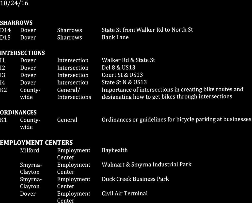
51

52

53
Bicycle/Pedestrian Subcommittee. Tuesday, February 7, :00 pm 6:00 pm Large Conference Room, City Hall Dover, DE AGENDA
 Bicycle/Pedestrian Subcommittee Tuesday, February 7, 2017 5:00 pm 6:00 pm Large Conference Room, City Hall Dover, DE AGENDA Welcome Approval of Agenda Approval of Meeting Minutes Old Business Items: o
Proposed. City of Grand Junction Complete Streets Policy. Exhibit 10
 Proposed City of Grand Junction Complete Streets Policy Exhibit 10 1 City of Grand Junction Complete Streets Policy Vision: The Complete Streets Vision is to develop a safe, efficient, and reliable travel
Chapter 2. Bellingham Bicycle Master Plan Chapter 2: Policies and Actions
 Chapter 2 Bellingham Bicycle Master Plan Chapter 2: Policies and Actions Chapter 2: Policies and Actions The Bicycle Master Plan provides a road map for making bicycling in Bellingham a viable transportation
Perryville TOD and Greenway Plan
 Perryville TOD and Greenway Plan Greenway Glossary Pathway: A bicycle and pedestrian path separated from motorized vehicular traffic by an open space, barrier or curb. Multi-use paths may be within the
ACTIVE TRANSPORTATION
 ACTIVE TRANSPORTATION Mobility 2040 Supported Goals Improve the availability of transportation options for people and goods. Support travel efficiency measures and system enhancements targeted at congestion
5. Pedestrian System. Accomplishments Over the Past Five Years
 5. Pedestrian System Accomplishments Over the Past Five Years The Alamo Area Metropolitan Planning Organization (MPO) and its partner agencies recognize the importance of improving pedestrian mobility.
Corpus Christi Metropolitan Transportation Plan Fiscal Year Introduction:
 Introduction: The Safe, Accountable, Flexible, Efficient Transportation Equity Act: A Legacy for Users (SAFETEA-LU) has continued the efforts started through the Intermodal Surface Transportation Efficiency
City of Novi Non-Motorized Master Plan 2011 Executive Summary
 City of Novi Non-Motorized Master Plan 2011 Executive Summary Prepared by: February 28, 2011 Why Plan? Encouraging healthy, active lifestyles through pathway and sidewalk connectivity has been a focus
RESOLUTION NO ?? A RESOLUTION OF THE CITY OF NEPTUNE BEACH ADOPTING A COMPLETE STREETS POLICY
 RESOLUTION NO. 2018-?? A RESOLUTION OF THE CITY OF NEPTUNE BEACH ADOPTING A COMPLETE STREETS POLICY WHEREAS, safe, convenient, and accessible transportation for all users is a priority of the City of Neptune
PEDESTRIAN ACTION PLAN
 ATTACHMENT 2 CITY OF SANTA MONICA PEDESTRIAN ACTION PLAN CITY OF SANTA MONICA PEDESTRIAN ACTION PLAN This page intentionally left blank EXECUTIVE SUMMARY CHAPTER 1 EXECUTIVE SUMMARY Setting the Stage
BIKE PLAN CONTENTS GATEWAY
 CONTENTS Acknowledgments...vii Great Rivers Greenway District Board of Directors... vii Great Rivers Greenway District Staff... vii Project Consultants... vii Committees... viii Citizens Advisory Committee
TOWN OF PORTLAND, CONNECTICUT COMPLETE STREETS POLICY
 TOWN OF PORTLAND, CONNECTICUT COMPLETE STREETS POLICY I. VISION, GOALS & PRINCIPLES VISION To improve the streets of Portland making them safer and more accessible for all users including pedestrians,
Bicycle Master Plan Goals, Strategies, and Policies
 Bicycle Master Plan Goals, Strategies, and Policies Mobilizing 5 This chapter outlines the overarching goals, action statements, and action items Long Beach will take in order to achieve its vision of
CITY OF COCOA BEACH 2025 COMPREHENSIVE PLAN. Section VIII Mobility Element Goals, Objectives, and Policies
 CITY OF COCOA BEACH 2025 COMPREHENSIVE PLAN Section VIII Mobility Element Goals, Objectives, and Policies Adopted August 6, 2015 by Ordinance No. 1591 VIII MOBILITY ELEMENT Table of Contents Page Number
CHAPTER 3: Vision Statement and Goals
 Davidson Walks & Rolls: Active Transportation Master Plan CHAPTER 3 Contents: Overview Vision Statement Measurable Goals Public Outreach CHAPTER 3: Vision Statement and Goals Overview The vision statement
The Florida Bicycle and Pedestrian Partnership Council
 The Florida Bicycle and Pedestrian Partnership Council Input to the Update of the Florida Transportation Plan March 2015 This document presents input from the Florida Bicycle and Pedestrian Advisory Council
CITY OF BLOOMINGTON COMPLETE STREETS POLICY
 CITY OF BLOOMINGTON COMPLETE STREETS POLICY POLICY OBJECTIVE: The City of Bloomington will enhance safety, mobility, accessibility and convenience for transportation network users of all ages and abilities,
Living Streets Policy
 Living Streets Policy Introduction Living streets balance the needs of motorists, bicyclists, pedestrians and transit riders in ways that promote safety and convenience, enhance community identity, create
Bicycle-Pedestrian Master Plan Update
 Bicycle-Pedestrian Master Plan Update Planning & Zoning Commission November 29, 2017 Overview Project Purpose & Scope Project History Plan Vision & Goals Chapter 5: Making Connections-Beyond the Path Next
Introduction.
 2307-1.0. Introduction. Delaware s Safe Routes to School (SRTS) Program was established September 10, 2002 when Governor Ruth Ann Minner signed Senate Bill 353 of the 141st General Assembly of Delaware
NM-POLICY 1: Improve service levels, participation, and options for non-motorized transportation modes throughout the County.
 Transportation PRINCE WILLIAM COUNTY 2008 COMPREHENSIVE PLAN NON-MOTORIZED PLAN CONTENTS Goals, Policies, and Action Strategies Table 4 (Bike Facility Classifications and Descriptions) Table 5 (Bike Facility
Exhibit 1 PLANNING COMMISSION AGENDA ITEM
 Exhibit 1 PLANNING COMMISSION AGENDA ITEM Project Name: Grand Junction Circulation Plan Grand Junction Complete Streets Policy Applicant: City of Grand Junction Representative: David Thornton Address:
University of Victoria Campus Cycling Plan Terms of Reference. 1.0 Project Description
 University of Victoria Campus Cycling Plan Terms of Reference 1.0 Project Description The Campus Cycling Plan, a first for the University, will provide a comprehensive and coordinated approach to support
DRAFT MOVING FORWARD RHODE ISLAND BICYCLE MOBILITY PLAN 2018 PREPARED FOR PREPARED BY IN ASSOCIATION WITH
 RHODE ISLAND MOVING FORWARD BICYCLE MOBILITY PLAN 2018 PREPARED FOR PREPARED BY IN ASSOCIATION WITH T AF CHAPTER 1 D R INTRODUCTION CHAPTER 3 ARTICULATES VISION Bicycling is safe, fun and practical in
Ann Arbor Downtown Street Plan
 1 Ann Arbor Downtown Street Plan Public Workshop #1 We know that. 2 Public right-of-way (streets, sidewalks, and alleys) make up 30% of the total District area of downtown. Streets need to provide mobility
Madison Urban Area and Dane County. Bicycle Transportation Plan Summary. September Introduction. Bicycle Plan Scope and Planning Process
 Bicycle Transportation Plan Summary Madison Urban Area and Dane County Introduction September 2000 Bicycling is an important mode of transportation in the Madison urban area and countywide that is available
Section 9. Implementation
 Section 9. Implementation The transportation system is just one of many aspects that must be carefully planned to maintain and enhance the quality of living in Cecil County. The Cecil County Bicycle Plan
CITY MANUALS AND STANDARDS REVIEW
 GEORGETOWN SIDEWALK MASTER PLAN CITY MANUALS AND STANDARDS REVIEW RESOURCES AND STANDARDS As part of the Master Plan process, a review and evaluation of current City documents and policies relevant to
Bicycle and Pedestrian Connectivity Study Phase 2
 Connectivity Study Phase 2 Process PROCESS OUTCOMES Phase Prepared By STEP I Public Participation and Outreach 1. RTP Outreach activities, and development of the Bike and Ped Task Force Phase 1 2011 OCPC
Environment and Public Works Committee Presentation
 Mixed Use Centers Complete Streets Guidelines Project Environment and Public Works Committee Presentation December 10, 2008 Project Objectives: Conduct an inter-departmental and agency process to study
Non-Motorized Transportation 7-1
 Non-Motorized Transportation 7-1 Transportation facilities no longer mean just accommodating a vehicle powered by a combustion engine. Pedestrian and non-motorized facilities are important modes of travel
Appendix C 3. Bicycle / Pedestrian Planning
 Appendix C 3. Bicycle / Pedestrian Planning BICYCLE/PEDESTRIAN PLANNING 2005 Master Plan GOAL: Provide for safe and convenient bicycle and pedestrian circulation throughout the City. Develop a city-wide
Executive Summary Route 30 Corridor Master Plan
 Route Corridor Master Plan Project Overview The Route Corridor Master Plan is a coordinated multimodal transportation and land use plan for the entire stretch of Route through East Whiteland Township,
Michael Parmer, Management Aide, City Manager's Office
 P139 STAFF REPORT f CITY NL- NAGER' S OFFICE RANCHO Date: C;UCAMONGA To: From: Subject: Mayor and Members of the City Council John R. Gillison, City Manager Michael Parmer, Management Aide, City Manager's
7 Complete Streets & Roadway Aesthetics
 7 Complete Streets & Roadway Aesthetics 7.1 OVERVIEW Our streets lay the foundation for how we interface with travel needs, physical exercise, social exchanges and access to goods and services. They are
APPENDIX A: Complete Streets Checklist DRAFT NOVEMBER 2016
 APPENDIX A: Complete Streets Checklist DRAFT NOVEMBER 2016 Complete Streets Checklist MetroPlan Orlando s Complete Streets Checklist is an internal planning tool for staff to further implementation of
CONNECTING PEOPLE TO PLACES
 CONNECTING PEOPLE TO PLACES 82 EAST BENCH MASTER PLAN 07 Introduction The East Bench transportation system is a collection of slow moving, treelined residential streets and major arteries that are the
GRAHAM PEDESTRIAN TRANSPORTATION PLAN
 GRAHAM PEDESTRIAN TRANSPORTATION PLAN Chapter 1 I 1.1 Scope and Purpose n March of 2005, the City of Graham contracted with Greenways Incorporated (GWI) to create a Pedestrian Transportation Plan. The
Chapter 5. Complete Streets and Walkable Communities.
 Chapter 5. Complete Streets and Walkable Communities. 5.1 Description of Complete Streets. Cities throughout the world, and specifically the United States, are coming to embrace a new transportation and
4 Goals, Objectives & Actions
 Chapter4 4 This chapter presents goals, objectives, and recommended actions to support the vision of making Overland Park a safer and easier place to ride a bicycle. 35 4.1 Recommendations Structure The
DRAFT. Table of Contents. Background
 Douglas County Table of Contents Existing Infrastructure 86 Funding 89 Policy and Program Recommendations 90 Infrastructure Recommendations 92 Conclusion 95 Background Home to 4,500 residents and Baker
City of Waterloo Complete Streets Policy
 City of Waterloo Complete Streets Policy Chris Hodgson P. Eng City of Waterloo Complete Streets Forum 2011 April 28-29 Toronto Waterloo context: Current population Major employers Universities and student
Chapter 14 PARLIER RELATIONSHIP TO CITY PLANS AND POLICIES. Recommendations to Improve Pedestrian Safety in the City of Parlier (2014)
") Chapter 14 PARLIER This chapter describes the current status and future plans for biking and walking in the City of Parlier. RELATIONSHIP TO CITY PLANS AND POLICIES The Parlier General Plan is the primary
Chapter 14 PARLIER This chapter describes the current status and future plans for biking and walking in the City of Parlier. RELATIONSHIP TO CITY PLANS AND POLICIES The Parlier General Plan is the primary
Stakeholder Communication and Public Involvement Plan
 Stakeholder Communication and Public Involvement Plan Arkansas Statewide Bicycle and Pedestrian Transportation Plan Plan purpose: The Arkansas State Bicycle and Pedestrian Plan will establish a framework
MEETING OF THE CITY OF CONCORD BICYCLE, PEDESTRIAN AND SAFE ROUTES TO TRANSIT PLAN ADVISORY COMMITTEE AGENDA
 MEETING OF THE CITY OF CONCORD BICYCLE, PEDESTRIAN AND SAFE ROUTES TO TRANSIT PLAN ADVISORY COMMITTEE Monday, June 22, 2015 5:30 p.m., Regular Meeting PERMIT CENTER CONFERENCE ROOM 1950 Parkside Drive,
FINAL PLAN APPENDIX D CITY OF BERKELEY BIKE PLAN D-1
 CITY OF BERKELEY BIKE PLAN D-1 . Proposed Programs D.1. EDUCATION This appendix presents the recommended bicycle-related programs for the City of Berkeley. The recommendations are organized in four E s:
WALKNBIKE DRAFT PLAN NASHVILLE, TENNESSEE EXECUTIVE SUMMARY NASHVILLE, TENNESSEE
 NASHVILLE, TENNESSEE EXECUTIVE SUMMARY Executive Summary A world-class multi-modal transportation system is essential to a vibrant city and better quality of life. -Mayor Barry The WalknBike plan aims
EXECUTIVE SUMMARY. Vision
 Vision Walking and bicycling in Salt Lake City will be safe, convenient, comfortable, and viable transportation options that connect people to places, foster recreational and economic development opportunities,
A CHANGING CITY. of Edmonton, it is essential that it reflects the long-term vision of the City.
 A CHANGING CITY By the year 2040, Edmonton will be home to more than 1 million people. To accommodate growth and support a healthy and compact city, we need a new approach to development/redevelopment
ACTIVE TRANSPORTATION/NONMOTORIZED TRANSPORTATION
 ACTIVE TRANSPORTATION/NONMOTORIZED TRANSPORTATION BACKGROUND Active transportation, also known as nonmotorized transportation, is increasingly recognized as an important consideration when planning and
Solana Beach Comprehensive Active Transportation Strategy (CATS)
") Solana Beach Comprehensive Active Transportation Strategy (CATS) 3.0 Goals & Policies The Solana Beach CATS goals and objectives outlined below were largely drawn from the Solana Beach Circulation Element
Solana Beach Comprehensive Active Transportation Strategy (CATS) 3.0 Goals & Policies The Solana Beach CATS goals and objectives outlined below were largely drawn from the Solana Beach Circulation Element
REGIONAL BICYCLE AND PEDESTRIAN DESIGN GUIDELINES
 REGIONAL BICYCLE AND PEDESTRIAN DESIGN GUIDELINES November 16, 2011 Deb Humphreys North Central Texas Council of Governments Bicycle and Pedestrian Advisory Committee Snapshot of the Guide 1. Introduction
Chapter 7. Transportation. Transportation Road Network Plan Transit Cyclists Pedestrians Multi-Use and Equestrian Trails
 Chapter 7 Transportation Transportation Road Network Plan Transit Cyclists Pedestrians Multi-Use and Equestrian Trails 7.1 TRANSPORTATION BACKGROUND The District of Maple Ridge faces a number of unique
Chapter VISION, MISSION, AND GOALS AND OBJECTIVES. Vision. Mission. Goals and Objectives CONNECTING COMMUNITIES ACROSS THE ST.
 VISION, MISSION, AND GOALS AND OBJECTIVES Chapter 3 The Plan s vision, mission, and goals and objectives were developed through a series of interactive exercises with the Citizens Advisory Committee (CAC)
Chapter PERFORMANCE MEASURES AND ACCOUNTABILITY. Introduction
 PERFORMANCE MEASURES AND ACCOUNTABILITY Introduction Performance measures are helpful in evaluating the progress being made toward achieving the goals and objectives of the Gateway Bicycle Plan. The Plan
Agenda. Overview PRINCE GEORGE S PLAZA METRO AREA PEDESTRIAN PLAN
 PRINCE GEORGE S PLAZA METRO AREA PEDESTRIAN PLAN May 28, 2008 Agenda Welcome and introductions Project overview and issue identification Planning context and strengths Design challenges and initial recommendations
NOTES FROM JUNIOR COUNCIL ORIENTATION SESSION HELD ON MONDAY, JANUARY 22, 2018, AT 3:30 PM IN COUNCIL CHAMBERS, CITY HALL
 CITY OF KAMLOOPS Junior Council Meeting Agenda March 12, 2018, at 3:30 pm in Council Chambers, 7 Victoria Street West, Kamloops, BC Page 1. APPROVAL OF THE AGENDA 2. MINUTES Attachment Recommendation:
CITY OF GRAND JUNCTION URBAN TRAILS COMMITTEE 2017 ANNUAL REPORT
 CITY OF GRAND JUNCTION URBAN TRAILS COMMITTEE 2017 ANNUAL REPORT INTRODUCTION INTRODUCTION Resolution No. 48 94 created the Grand Junction Trails Board in 1994 as a subcommittee of the Riverfront Commission
Eastern PA Trail Summit October 1, 2018
 Eastern PA Trail Summit October 1, 2018 WHO WE ARE + WHY + WE RE * HERE * * * * * * Session Goals: Discuss how to coordinate planning and design in small, urbanized towns Consider how to develop alternative
Omaha s Complete Streets Policy
 Omaha s Complete Streets Policy (Adopted August 2015) VISION To create great places and enhance our quality of life, the City of Omaha will provide safe, accessible streets for all users. Complete Streets
Plant City Walk-Bike Plan
 Plant City Walk-Bike Plan Plant City Commute Mode Share 2.2% 1.4% 2.9% Drove alone 10.2% Carpooled Public transportation (0.1%) Walked Used a Bike (0.4%) 82.9% Taxicab, motorcycle, or other means Worked
Berkeley Strategic Transportation Plan A-76
 Berkeley Strategic Transportation Plan A-76 Appendices 1. A Team Effort 2. Where We ve Been A-11 Berkeley Strategic Transportation Plan Alameda County Transportation Plan Alameda County will be served
MASTER BICYCLE AND PEDESTRIAN PLAN
 VILLAGE OF NORTHBROOK MASTER BICYCLE AND PEDESTRIAN PLAN DRAFT PLAN OPEN HOUSE May 2, 2018 AGENDA 1. Community Engagement 2. Vision and Goals 3. General Structure of Plan 4. Recommendations Overview 5.
COMMUNITY PARTICIPATION CHAPTER 8
 COMMUNITY PARTICIPATION CHAPTER 8 8.1 ROLE OF THE CITY S BICYCLE ADVISORY COMMISION 8.2 BICYCLE TRANSPORTATION PLAN STAKEHOLDERS 8.2.1 Stakeholders 8.2.2 Stakeholders Letters of Recommendations 8.3 CITY
Rochester Downtown Bicycle Study 2009
 Rochester Downtown Bicycle Study 2009 Relationship of ROCOG Long Range Transportation Plan to Rochester Comprehensive Plan Regional Long Range Transportation Plan (LRTP) is prepared under the auspices
Strategy for Walking & Cycling Action Plan
 Strategy for Walking & Cycling Action Plan To achieve higher levels of walking and cycling activity, the destinations which people access have to be available within suitable distances and designed to
INDOT Complete Streets Guideline & Policy
 INDOT Complete Streets Guideline & Policy INTRODUCTION The Complete Streets guidelines build upon multiple efforts and promote a multimodal transportation system that is integrated and sustains land use
Hennepin County Bicycle and Pedestrian Planning
 Hennepin County Bicycle and Pedestrian Planning 1 Value of bicycle and sidewalk systems Safety Livability Mobility Health Personal Finances Economic Sustainability Clean Air Recreation Parking and congestion
TRAVEL PLAN: CENTRAL EUROPEAN UNIVERSITY CAMPUS REDEVELOPMENT PROJECT TRAVEL PLAN. Central European University Campus Redevelopment Project.
 TRAVEL PLAN Central European University Campus Redevelopment Project Page 1 Table of Contents Introduction... 3 Background... 7 Building Users... 7 Transportation in Community Consultation... 7 Summary
Roadway Classification Design Standards and Policies. Pueblo, Colorado November, 2004
 Roadway Classification Design Standards and Policies Pueblo, Colorado November, 2004 Table of Contents Page Chapter 1. General Provisions 1.1 Jurisdiction 3 1.2 Purpose and Intent 3 1.3 Modification 3
City of Jacksonville Mobility Fee Update
 City of Jacksonville Mobility Fee Update 2017 Preliminary Analysis May 3, 2017 Carnival Cruise lines photo credit Presentation Overview Public Outreach Process Pedestrian and Bicycle Master Plan Study
Bicycle and Pedestrian Advisory Committee (BPAC) November 21, 2013
 November 21, 2013") Bicycle and Pedestrian Advisory Committee (BPAC) November 21, 2013 OVERALL LAND USE CONCEPT Overall Broadway Valdez District: 95.5 acres (35.1 acres right-of ways + 60.4 acres developable land) Plan Subareas:
Bicycle and Pedestrian Advisory Committee (BPAC) November 21, 2013 OVERALL LAND USE CONCEPT Overall Broadway Valdez District: 95.5 acres (35.1 acres right-of ways + 60.4 acres developable land) Plan Subareas:
COUNCIL POLICY NAME: COUNCIL REFERENCE: 06/119 06/377 09/1C 10llC 12/1C INDEX REFERENCE: POLICY BACKGROUND
 COUNCIL POLICY NAME: COUNCIL ADVISORY COMMITTEES - TERMS OF REFERENCE ISSUED: APRIL 3, 2006 AMENDED: NOVEMBER 27, 2006 NOVEMBER 23, 2009 JANUARY 11, 2010 DECEMBER 17, 2012 POLICY COUNCIL REFERENCE: 06/119
Gordon Proctor Director Policy on Accommodating Bicycle and Pedestrian Travel on ODOT Owned or Maintained Facilities
 Approved: Policy: 20-004(P) Responsible Office: Planning Gordon Proctor Director Policy on Accommodating Bicycle and Pedestrian Travel on ODOT Owned or Maintained Facilities I. POLICY STATEMENT: This policy
PRINCE GEORGE S PLAZA METRO AREA PEDESTRIAN PLAN
 PRINCE GEORGE S PLAZA METRO AREA PEDESTRIAN PLAN May 28, 2008 Agenda Welcome and introductions Project overview and issue identification Planning context and strengths Design challenges and initial recommendations
MnDOT Implementation of Complete Streets Policy. January 2014
 MnDOT Implementation of Complete Streets Policy January 2014 1 Prepared by Minnesota Department of Transportation 395 John Ireland Boulevard Saint Paul, Minnesota 55155-1899 Phone: 651-296-3000 Toll-Free:
Getting Your SRTS Project Funded. Ryan Snyder
 Getting Your SRTS Project Funded Ryan Snyder Steps in Submitting a Successful Application 1. Stakeholder outreach: create a SRTS coalition 2. Develop a comprehensive plan and program with all 5 Es 3. Conceive
STONY PLAIN ROAD STREETSCAPE
 Jasper Place Revitalization Strategy: Vision The people involved in the Jasper Place Revitalization Strategy envision: Goal 1: Feeling safe in our community Create a community where feeling safe is common--where
 MEMORANDUM - CITY OF PASADENA Department Of Transportation DATE: OCTOBER 21, 2008 TO: ENVIRONMENTAL ADVISORY COMMISSION FROM: ~ FRED C. DOCK, DIRECTOR OF TRANSPORTATION SUBJECT: UPDATE ON DEPT. OF TRANSPORTATION
COMPLETE STREETS POLICY Exhibit A to Ordinance
 CITY OF WENATCHEE COMPLETE STREETS POLICY Exhibit A to Ordinance 2016-24 Prepared and Reviewed By: City of Wenatchee Community & Economic Development Department City of Wenatchee Public Works Department
Section 8. Partnerships and Funding
 This section discusses the potential partnership and funding options that the Town should consider in order to assist with the implementation of the recommendations provided in the Plan. Section 8. Partnerships
Safe Routes to School Action Plan Aberdeen, Idaho
 Background Aberdeen, Idaho is a largely agricultural community of nearly 2,000 people and is located in the southeast portion of the state on the western edge of American Falls Reservoir. The community
o n - m o t o r i z e d transportation is an overlooked element that can greatly enhance the overall quality of life for the community s residents.
 N o n - m o t o r i z e d transportation is an overlooked element that can greatly enhance the overall quality of life for the community s residents. 84 Transportation CHAPTER 11 INTRODUCTION Transportation
EXECUTIVE SUMMARY: TRANSIT-ORIENTED DEVELOPMENT IN SMITHS FALLS, ONTARIO; A COMPARISON BETWEEN TWO SITES
 EECUTIVE SUMMARY: TRANSIT-ORIENTED DEVELOPMENT IN SMITHS FALLS, ONTARIO; A COMPARISON BETWEEN TWO SITES Topic and Purpose In 2007, the Mayor of Ottawa s Task Force on Transportation suggested adding a
Transportation Master Plan Advisory Task Force
 Transportation Master Plan Advisory Task Force Network Alternatives & Phasing Strategy February 2016 BACKGROUND Table of Contents BACKGROUND Purpose & Introduction 2 Linking the TMP to Key Council Approved
ATTACHMENT 4 - TDM Checklist. TDM Checklist Overview
 ATTACHMENT 4 - TDM Checklist TDM Checklist Overview The proposed checklist rates developments on the degree to which they are TDM and transit supportive. Points are assigned based on the level of transit
CHAPTER 7.0 IMPLEMENTATION
 CHAPTER 7.0 IMPLEMENTATION Achieving the vision of the Better Streets Plan will rely on the ability to effectively fund, build and maintain improvements, and to sustain improvements over time. CHAPTER
Table of Contents Introduction. 2 Purpose of the Plan...2 The Benefits of Walking and Bicycling...3 Vision and Goals of the Plan...
 BICYCLE AND This plan was created through a grant from the Healthy Communities Program with the cooperation of the City of Cynthiana, Cynthiana Main Street, Cynthiana-Harrison County-Berry Joint Planning
NON-MOTORIZED TRANSPORTATION
 NON-MOTORIZED TRANSPORTATION This chapter discusses bicycle and pedestrian initiatives, non-motorized goals and objectives, safety, education, and regional enforcement efforts, key area infrastructure,
Speed Limits Study and Proposal. Public Input Session: 8/14/13
 Speed Limits Study and Proposal Public Input Session: 8/14/13 Why is Decatur a unique place for this project? First Community Transportation Plan in the nation with a Health Impact Assessment. Strong sense
1. Engineering: An Inviting Network of Bicycling Facilities for Cyclists of All Ages and Abilities and Destinations that Support Bicycling
 This Plan lays out a framework for creating and expanding programs and improvements to increase bicycling in Greenville. The Vision, Goals, and Objectives of the City of Greenville Bicycle Master Plan
EXECUTIVE DIRECTIVE NO. 20. Issue Date: July 1, 2011
 ANTONIO R. VILLARAIGOSA MAYOR EXECUTIVE DIRECTIVE NO. 20 Issue Date: July 1, 2011 SUBJECT: Implementation of the 2010 Bicycle Plan It is no secret that the quality of life in Los Angeles is directly influenced
Thank you for this opportunity to discuss with you how we can work together to make our streets more complete.
 Thank you for this opportunity to discuss with you how we can work together to make our streets more complete. 1 2 3 Thank you for this opportunity to discuss with you how we can work together to make
Promoting Active Communities Award Application
 Promoting Active Communities Award Application Michigan s Promoting Active Communities (PAC) assessment and award application is available for online completion and submission at www.mihealthtools.org/communities.
5 CIRCULATION AND STREET DESIGN
 5 CIRCULATION AND STREET DESIGN This chapter describes circulation and streetscape improvements proposed for the Northwest Chico Specific Plan Area. It includes detailed design specifications for existing
SUPPORTING DOCUMENTATION PROPOSED TRAILS DEVELOPMENT AND IMPLEMENTATION PLAN
 SUPPORTING DOCUMENTATION PROPOSED TRAILS DEVELOPMENT AND IMPLEMENTATION PLAN Prepared For: Prepared By: Town of Rocky Mountain House Recreation, Parks and Community Services 1 INTRODUCTION 1.1 Purpose
Strategies to Promote the Availability of Affordable Healthy Food and Beverages
 Strategies to Promote the Availability of Affordable Healthy Food and Beverages CDC Recommended Strategies and Measurements Strategy #1: Communities Should Increase Availability of Healthier Food and Beverage
MEETING Agenda. Introductions. Project Overview. Key Study Components. Alternative Station Concepts. Preferred Station Concept. Next Steps.
 City GARLAND Council ROADVISION Briefing STUDY VISION STUDY Dallas, TX April 8, 2010 1 1 MEETING Agenda Introductions Project Overview Key Study Components Alternative Station Concepts Preferred Station
Goal 3: Foster an environment of partnerships and collaboration to connect our communities and regions to one another.
 Non-Motorized Transportation Plan (NMTP) Draft Vision, Goal and,, Tri-County Regional Planning Commission (TCRPC) Purpose The purpose of the Tri-County Regional Planning Commission (TCRPC) Non-Motorized
May 12, 2016 Metro Potential Ballot Measure Issue Brief: Local Return
 Summary: Local return is an important revenue source for cities to maintain their local transportation infrastructure. Most cities use their local return to operate small bus systems and repave streets,