Mackerel Beach and Resolute Loop
|
|
|
- Felicia Wilcox
- 5 years ago
- Views:
Transcription


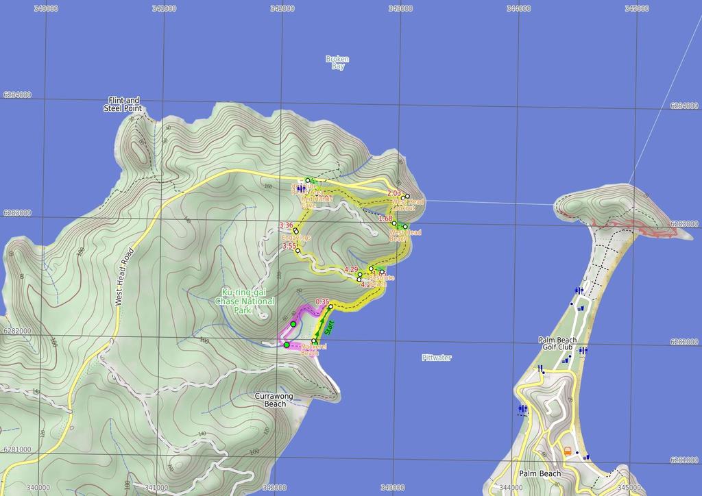
1 Mackerel Beach and Resolute Loop 3 hrs 5.4 km Circuit Hard track 384m This walk is another great walk in Ku-ring-gai Chase National Park, accessed by ferry. From the Mackerel Beach wharf, this walk uses the Resolute Loop track to round the headland, enjoying a few secluded beaches and excellent, historic Aboriginal sites. This walk features Mackerel Beach and community, with an alternative route through the town which is well worth the walk m Maps, text & images are copyright wildwalks.com Thanks to OSM, NASA and others for data used to generate some map layers. 1m Ku-ring-gai Chase National Park

2 Mackerel Beach Mackerel Beach, also known as Great Mackerel Beach, is a 6m stretch of sand facing east over Pittwater. The beach is backed by a lagoon and a small community of houses. Mackerel Beach has a wharf with public ferry access. Mackerel Beach and its southern neighbour, Little Mackerel or Currawong Beach, were originally purchased for farming in 1823 by John Clarke. The land was then subdivided and more than a hundred houses were built, many of which still stand today. Resolute Beach Resolute Beach, Ku-ring-gai Chase National Park, is a small stretch of sand sitting on the West Head Peninsula between steep headlands. The easterly aspect of the beach overlooks Barrenjoey Headland across the Pittwater. West Head Beach West Head Beach, Ku-ring-gai Chase National Park, is a small stretch of sand sitting on the West Head Peninsula. The beach has an easterly aspect, facing out of steep hills over Pittwater to the Barrenjoey Headland. West Head Lookout West Head Lookout, Ku-ring-gai Chase National Park is a large sandstone viewing area with many interpretive signs. The view spans across the Hawkesbury River to Lion Island, Patonga Sport and Recreation, Box Headland and over to the Barrenjoey Headland. The lookout has a number of bench seats and a low stone fence. Resolute Picnic Area Resolute picnic area, Ku-ring-gai Chase National Park, is a large grassed area with benches, shelter, interpretive signs, electric BBQ's and an environmentally-friendly toilet block. The picnic area does not have drinking water, but does have a pay phone and wheelchairaccessible bathroom with baby-changing area. Resolute picnic area is a great place for lunch, with Red Hands Cave, West Head and Resolute Beach and West Head Lookout tracks starting from the picnic area. The picnic area has adequate parking and a bus turnaround area. Before You walk Bushwalking is fun and a wonderful way to enjoy our natural places. Sometimes things go bad, with a bit of planning you can increase your chance of having an ejoyable and safer walk. Before setting off on your walk check 1) Weather Forecast (BOM Metropolitan District) 2) Fire Dangers (Greater Sydney Region) 3) Park Alerts (Ku-ring-gai Chase National Park) 4) Research the walk to check your party has the skills, fitness and equipment required 5) Agree to stay as a group and not leave anyone to walk solo Think before you TREK The 'Think before you TREK' program developed by NSW Police & NPWS promotes the benefits of planning ahead for your bushwalking trip by using an easy to remember acronym: T R E K Take adequate supplies of food, water, navigation and first aid equipment. Register your planned route and tell friends and family when you expect to return. Emergency beacon (PLB's) should be carried on walks with significant gaps in mobile coverage (check terrain profile). Keep to your planned route and follow the map and walking trails. Topo Maps The maps provided on wildwalks are helpful, but there are times where you may need maps covering a broader area. Maps that cover this walk include; 1:25 Map Series:9131N BROKEN BAY 1:4 Map Series:CMA Ku-ring-gai Chase National Park Tourist Map 1:1 Map Series:913 SYDNEY Grade This walk has been graded using the AS The overall grade of the walk is dertermined by the highest classification along the whole track. 4 Length Time Quality of track Grade 4/6 Hard track 5.4 km Circuit 3 hrs Rough track, where fallen trees and other obstacles are likely (4/6) Signs Minimal directional signs (4/6) Experience Required Weather Infrastructure Some bushwalking experience recommended (3/6) Weather generally has little impact on safety (1/6) Limited facilities (such as cliffs not fenced, significant creeks not bridged) (4/6)
3 Are you ready to have fun? Please ensure you and your group are well prepared and equipped for all possible hazards and delays. Check park closures, weather information and Fire Danger Rating before setting out. Optional side trips and alternate routes noted are not included in this walks overall grade, length or time estimate. Please allow extra time for resting and exploring areas of interest. The authors, staff and owners of wildwalks take care in preparing this information but will not accept responsibility for any inconvenience, loss or injury you may experience. Please take care, have fun - Happy Walking. Getting there Traveling by ferry is the only practical way to get to Mackerel Beach Wharf (gps: , ). Ferry: Palm Beach Ferry service operates hourly from 9am to about 8pm - check their timetable for more info. The ferry starts at Palm Beach and goes via Bennett's, Bonnie Doon, The Basin, Currawong then Mackerel. Ph: This is a circuit, so you will finish back at the start. Find up to date and more information inlcuding; travel directions, weather, park closures and walker feedback at Alternate Route Mackerel Beach Wharf to Palm Trees (1 km 21 mins) From the wharf, this walk follows the tarmac pavement to the the corner beneath a large, yellow 'Submarine Cable' sign. The track then turns right, heading along a grassy pathway of Monash Ave. The walk continues along this for approximately 3m to a bridge. Continue straight: From the bridge, this walk crosses the bridge and leads along the grassy path of Diggers Crescent. The walk turns right after approximately 1m, then continues another 1m to a large shed, the 'Mackerel Beach Bush Fire Brigade' shed. Continue straight: ****Warning: This section of track has been reported as overgrown and no longer passable**** From the shed, this walk passes along the left side of the shed, to a small grassy clearing near a lagoon. The walk travels alongside the lagoon for approximately 3m, tending right with the lagoon to open onto a sandy creek bed behind the beach. This walk then continues to the right side of the creek, to continue to the two palm trees on this end of Mackerel Beach. A boulder below the two trees is painted with a black arrow. Now Turn right to rejoin the main walk. Mackerel Beach Wharf (35 m 6 mins) Turn sharp left: From the wharf, the walk heads along the beach (keeping the water to your right) for approximately 3m, to the only palm trees on this end of the beach. Below the palm trees is a boulder with a black arrow painted on it..35 Mackerel Beach Mackerel Beach, also known as Great Mackerel Beach, is a 6m stretch of sand facing east over Pittwater. The beach is backed by a lagoon and a small community of houses. Mackerel Beach has a wharf with public ferry access. Mackerel Beach and its southern neighbour, Little Mackerel or Currawong Beach, were originally purchased for farming in 1823 by John Clarke. The land was then subdivided and more than a hundred houses were built, many of which still stand today..35 Palm Trees North end of Mackerel Beach (7 m 2 mins) Continue straight: From the palm trees and boulder painted with a black arrow, this walk heads up the hill into the bush, away from the beach. The track climbs to pass a 'Ku-ring-gai Chase National Park' sign before meandering along the hillside in an easterly direction, up the hill for approximately 4m. The track then rounds the headland to lead beneath a rocky headland for some time to a signposted intersection. Continue straight: From the intersection, this walk follows the 'Resolute' Beach arrow along the hillside to an un-signposted intersection. 1.5 Optional sidetrip to Resolute Beach (1 m 3 mins) Turn right: From the intersection, this walk heads down the hill towards the water, following the creek line to the beach. The track winds down the hill for approximately 3m to a small creek waterfall. The track is hidden in parts by grasses for approximately 2m before it heads down a few flights of stairs to where the track reaches the beach. At the end of this side trip, retrace your steps back to the main walk then Turn right. 1.5 Resolute Beach Resolute Beach, Ku-ring-gai Chase National Park, is a small stretch of sand sitting on the West Head Peninsula between steep headlands. The easterly aspect of the beach overlooks Barrenjoey Headland across the Pittwater. 1.5 Int. Resolute Bch Trk and Mackerel Bch Trk (63 m 2 mins) Veer left: From the intersection, this walk keeps the water on the right of the track as it follows the hillside around through a creek. The track then turns right, following the coast. The track rises up the hill closer to the cliffline as it heads around a spur. When passing this spur, a gun emplacement is passed (below to the right of the track). The track continues for approximately 2m, undulating around the hillside to the intersection with some steps on the right (which go down to West Head Beach) Optional sidetrip to West Head Beach (1 m 3 mins) Turn right: From the intersection, this walk heads down the staircases to the beach, approximately 1m below. At the end of this side trip, retrace your steps back to the main walk then Veer right West Head Beach West Head Beach, Ku-ring-gai Chase National Park, is a small stretch of sand sitting on the West Head Peninsula. The beach has an easterly aspect, facing out of steep hills over Pittwater to the Barrenjoey Headland Int. West Head Beach and West Head Lookout (35 m 13 mins) Veer left: From the intersection, this walk heads up the hill, keeping the water to the right of the track. The walk then turns up two flights of stairs. These staircases pass a small creek waterfall on the right, and a prominent overhang on the left. The track then continues to climb up the ridge, with many sections of cut rock steps. In time, the walk flattens out and continues past an informal, unfenced lookout on a rock landing approximately 1m before this walk reaches the stone-fenced West Head Lookout. 2.3 West Head Lookout West Head Lookout, Ku-ring-gai Chase National Park is a large sandstone viewing area with many interpretive signs. The view spans across the Hawkesbury River to Lion Island, Patonga Sport and Recreation, Box Headland and over to the Barrenjoey Headland. The lookout has a number of bench seats and a low stone fence. 2.3 West Head Lookout (82 m 2 mins) Turn left: From West Head Lookout, this walk follows the sign to 'Resolute Picnic Area' along a bush track, which keeps the hill above on the right. The track continues along the hillside to pass a sign pointing to 'Resolute Picnic Area' before the track climbs up steps. The track passes a creek on the left and rock formations on the right as the steps lead to the signposted 'Red Hands Cave' intersection Optional sidetrip to Resolute Picnic Area (13 m 3 mins) Turn right: From the intersection, the walk heads along the rocky outcrop keeping it on the left as it heads up the stairs for approximately 3m into Resolute Picnic Area. At the end of this side trip, retrace your steps back to the main walk then Continue straight Resolute Picnic Area Resolute picnic area, Ku-ring-gai Chase National Park, is a large grassed area with benches, shelter, interpretive signs, electric BBQ's and an environmentally-friendly toilet block. The picnic area does not have drinking water, but does have a pay phone and wheelchair-accessible bathroom with baby-changing area. Resolute picnic area is a great place for lunch, with Red Hands Cave, West Head and Resolute Beach and West Head Lookout tracks starting from the picnic area. The picnic area has adequate parking and a bus turn-around area Int. West Head Lookout Trk and Red Hands Cave Trk (2 m ) Turn left: From the intersection, the walk heads down the hill, following the rocky outcrop to the right of the track. The walk follows this for approximately 3m to the interpretation signs for Red Hands Cave Red Hands Cave Red Hands Cave, Ku-ring-gai Chase National Park, is a small rock overhang just near Resolute Picnic Area. The red hands are made by ochre, clay, being blown over an outspread hand. This Aboriginal rock art has been given an estimation of approximately 2 years in age Red Hands Cave (13 m 2 mins) Continue straight: From Red Hands Cave, this walk heads along the bottom of the rocky outcrop, keeping it to the right of the track. The walk then ascends some stairs, passing up and around the rock shelf. After this, the track turns left as it continues, climbing slightly to the signposted intersection with the service trail. 3 Int. West Head Trk and Red Hands Cave Trk (36 m 6 mins) Turn left: From the intersection, this walk heads down the hill for a short time, to the information sign on the left of the track Engavings The engravings on West Head were made by the indigenous Guringai people. The engravings depict a man, shark/whale and two eels Engravings (19 m 4 mins) Turn left : From the engraving of the man, this walk heads off the rock shelf near a vegetation-covered sign indicating the 'Headland Track'. The track winds through dense scrub for about 2m to the intersection with the management trail, the Headland Track Int. Headland Track and Engravings Bushtrack (68 m 14 mins) Veer left: From the intersection, this walk heads down the hill towards the water for some time. After a few turns in the service trail, the track winds down a steep slope for approximately 3m to the intersection, where there is a sign indicating the way to 'Resolute Beach' Int. Headland Track and Resolute Beach Trk (6 m 2 mins) Veer left: From the intersection, this walk heads down a flight of stairs following the sign to 'Resolute Beach'. The walk then turns left down more steps to head below a small cliffline, and comes to a sign at an intersection with a track on the left (which heads down to a cave) Optional sidetrip to Cave (2 m 1 mins) Veer left: From the intersection, this walk heads towards the rock formations, following the hillside. The track then enters an overhang of a cave. At the end of this side trip, retrace your steps back to the main walk then Veer left.

4 4.29 Int. Cave Trk and Resolute Beach Trk (1.1 km 29 mins) Turn right: From the intersection, this walk heads down the hill for approximately 5m towards the sea. The track then heads down a flight of stairs and continues down another staircase to the intersection, marked 'Mackerel' and 'Resolute' beaches. Turn right: From the intersection, this walk follows the signpost to 'Mackerel' heading along the hillside beneath a rocky outcrop on the headland. The track then meanders along the hillside, undulating slightly for approximately 4m to pass a 'Ku-ring-gai Chase National Park' sign. From the sign, the walk then heads down to two palm trees and a boulder painted with a black arrow on the beach. Continue straight: From the arrow painted boulder, the walk heads along the beach, keeping the water to the left. After approximately 3m, the walk comes to the wharf in the middle of the beach.
5
6 Powered by TCPDF ( Summary navigation sheet for the Mackerel Beach and Resolute Loop km From Up/Dwn Length Initial directions (Use full tracknotes and maps for more detail). Mackerel Beach Wharf , (GR Broken Bay, 42382). Mackerel Beach Wharf , (GR Broken Bay, 42382).35 Palm Trees North end of Mackerel Beach , (GR Broken Bay, ) 1.5 Int. Resolute AND West Head Beach Tracks , (GR Broken Bay, ) 1.5 Int. Resolute Bch Trk and Mackerel Bch Trk , (GR Broken Bay, ) 1.68 Int. West Head Beach and West Head Lookout , (GR Broken Bay, 4383) 1.68 Int. West Head Beach and West Head Lookout , (GR Broken Bay, 4383) 2.3 West Head Lookout , (GR Broken Bay, 43832) 2.84 Int. West Head Lookout Trk and Red Hands Cave Trk , (GR Broken Bay, ) 2.84 Int. West Head Lookout Trk and Red Hands Cave Trk , (GR Broken Bay, ) 2.87 Red Hands Cave , (GR Broken Bay, ) 3. Int. West Head Trk and Red Hands Cave Trk ,151.3 (GR Broken Bay, ) 3.36 Engravings , (GR Broken Bay, ) 3.55 Int. Headland Track and Engravings Bushtrack , (GR Broken Bay, ) 4.23 Int. Headland Track and Resolute Beach Trk , (GR Broken Bay, ) 4.29 Int. Cave Trk and Resolute Beach Trk , (GR Broken Bay, ) 4.29 Int. Cave Trk and Resolute Beach Trk , (GR Broken Bay, ) km 21 mins 35 m 6 mins 7 m 2 mins 1 m 3 mins 63 m 2 mins 1 m 3 mins 35 m 13 mins 82 m 2 mins 13 m 3 mins Alternate Route Mackerel Beach Wharf. From the wharf, this walk follows the tarmac pavement to the the corner beneath a large, yellow 'Submarine Cable' sign. Turn sharp left: From the wharf, the walk heads along the beach (keeping the water to your right) for approximately 3m, to the only palm trees on this end of the beach. Continue straight: From the palm trees and boulder painted with a black arrow, this walk heads up the hill into the bush, away from the beach. Optional sidetrip to Resolute Beach. Turn right: From the intersection, this walk heads down the hill towards the water, following the creek line to the beach. Veer left: From the intersection, this walk keeps the water on the right of the track as it follows the hillside around through a creek. Optional sidetrip to West Head Beach. Turn right: From the intersection, this walk heads down the staircases to the beach, approximately 1m below. Veer left: From the intersection, this walk heads up the hill, keeping the water to the right of the track. Turn left: From West Head Lookout, this walk follows the sign to 'Resolute Picnic Area' along a bush track, which keeps the hill above on the right. Optional sidetrip to Resolute Picnic Area. Turn right: From the intersection, the walk heads along the rocky outcrop keeping it on the left as it heads up the stairs for approximately 3m into Resolute Picnic Area. 2 m Turn left: From the intersection, the walk heads down the hill, following the rocky outcrop to the right of the track. 13 m 2 mins 36 m 6 mins 19 m 4 mins 68 m 14 mins 6 m 2 mins 2 m 1 mins 1.1 km 29 mins Continue straight: From Red Hands Cave, this walk heads along the bottom of the rocky outcrop, keeping it to the right of the track. Turn left: From the intersection, this walk heads down the hill for a short time, to the information sign on the left of the track. Turn left : From the engraving of the man, this walk heads off the rock shelf near a vegetation-covered sign indicating the 'Headland Track'. Veer left: From the intersection, this walk heads down the hill towards the water for some time. Veer left: From the intersection, this walk heads down a flight of stairs following the sign to 'Resolute Beach'. Optional sidetrip to Cave. Veer left: From the intersection, this walk heads towards the rock formations, following the hillside. Turn right: From the intersection, this walk heads down the hill for approximately 5m towards the sea.
Mackerel Beach, West Head Loop
 Mackerel Beach, West Head Loop 5 hrs 8.6 km Circuit Hard track 422m The Mackerel Beach, West Head Loop is a walk which explores a large part of the West Head. The journey starts and finishes with a ferry
The Basin Track and Mackerel Track
 The Basin Track and Mackerel Track 3 hrs 5.9 km Circuit Hard track 226m This walk is a great way to see some popular areas in Ku-ring-gai Chase National Park. The walk from West Head Rd travels to The
Govetts Leap Loop. 1065m. 909m Blue Mountains National Park. 4 hrs 30 mins 8.7 km Circuit. Hard track 380m
 Govetts Leap Loop 4 hrs 30 mins 8.7 km Circuit Hard track 380m This walk, from Blackheath Train Station, is a fantastic way to see some of the iconic areas of the Blue Mountains in the Blackheath area.
Popes Glen, Pulpit Rock, Govetts Leap and Braeside Walk
 Popes Glen, Pulpit Rock, Govetts Leap and Braeside Walk 8 hrs Hard track 13.6 km Circuit 4 1068m This large circuit walk, from Popes Glen to Pulpit Rock, Govetts leap and along the Braeside Track, passes
Little Digger Track to Davidson Reserve and Lyrebird Circuit
 Little Digger Track to Davidson Reserve and Lyrebird Circuit 4 hrs 3 mins 11.5 km One way Hard track 4 47m Exploring both the eastern and western sides of Middle Harbour Creek, this walk follows the Little
Wattamolla to Big Marley Beach
 Wattamolla to Big Marley Beach 4 hrs 10.4 km Circuit Moderate track 4m This walk is an excellent loop which takes in both the coast and the heathy inland of Royal National Park. Nearly the whole walk has
Heathcote to Engadine via Audley
 Heathcote to Engadine via Audley 6 hrs 3 mins 5 km One way Hard track 4 635m Covering a large section of central Royal National Park, this walk goes through the heath and scrub along a well managed and
Echo Point to Leura Forest via Three Sisters and Giant Stairs loop
 Echo Point to Leura Forest via Three Sisters and Giant Stairs loop 3 hrs 3.8 km Circuit Hard track 512m This walk starts from the popular Echo Point, in Katoomba, and winds down to the base of the Three
Currie Rd to Davidson Park
 Currie Rd to Davidson Park 3 hrs 7.2 km One way Moderate track 28m Starting at Currie Rd in Forestville, this walk follows Middle Harbour to Davidson Park, under Roseville Bridge. There are two optional
Little Digger Track. 68m. 1 Hr 2.2 km One way. Moderate track 93m. Moores Creek Reserve
 Little Digger Track Hr 2.2 km One way Moderate track 93m This walk follows Moores Creek through several reserves in east Roseville and East Lindfield. The track is named after Australia's 7th Prime Minster,
Bouddi Coastal Walk. 5 hrs. Hard track 8.1 km One way. 364m
 Bouddi Coastal Walk 5 hrs Hard track 8.1 km One way 4 364m This is one of the longer walks in the Bouddi National Park and it is rich in scenery. The walk follows the coastline with many side trips to
Hunters Hill to Epping Road
 Hunters Hill to Epping Road 2 hrs 30 mins 5.5 km One way Moderate track 154m An enjoyable walk through lower sections of the Lane Cove National Park, this walk features plenty of mangroves next to the
Wentworth Falls Conservation Hut Loop
 Wentworth Falls Conservation Hut Loop 3 hrs Hard track 6.7 km Circuit 4 341m This scenic walk from Wentworth Falls Station, winds along the Nature Trail to Conservation Hut, then drops into the magnificent
Morgans Creek to Padstow
 Morgans Creek to Padstow 2 hrs 45 mins 8 km One way Moderate track 3 144m This pleasant walk starts from the Morgans Creek park, at Henry Lawsons Drive, and follows the Georges River past the Boomerang
Campbell Drive to Snapper Point
 Campbell Drive to Snapper Point 1 hr 45 mins 4.2 km One way Experienced only 135m This walk follows the Coast Track to Frazer Beach, along the Geebung and (overgrown) Grass Tree Tracks. From the northern
Rail to River Walk. 3 hrs. Hard track 7.5 km Circuit. 222m
 Rail to River Walk 3 hrs Hard track 7.5 km Circuit 4 222m This walk is a great one from Chatswood Station to the Lane Cove River National Park. The walk descends through the vegetated bushland which fills
The Foreshore Walk. 24m. 1m Lake Macquarie LGA. 1 hr 15 mins 2.9 km One way. Hard track 81m
 The Foreshore Walk 1 hr 15 mins 2.9 km One way Hard track 81m This walk traverses the coastline of the Green Point reserve. By following a variety of tracks and occasionally traveling inland through eucalyptus
Carrington Park to Leura Forest and pass loop
 Carrington Park to Leura Forest and pass loop 3 hrs Hard track 4.8 km Circuit 4 674m This walk is a fantastic way to see Leura Forest. The walk descends from Carrington Park, visiting Leura Forest and
Waterfall to Heathcote
 Waterfall to Heathcote 5 hrs Hard track 10.8 km One way 4 467m This walk explores the heart of Heathcote National Park, and is easily accessed with a train station at either end. Although relatively close
Wallarah Coastal Walk
 Wallarah Coastal Walk 3 hrs 8.3 km Return Hard track 247m This walk starts at Caves Beach and travels south along the coastline, until reaching the Pinney s Headland Lookout. There are many opportunities
Sid Pulsford Walk. 175m. 33m. 1 hr 45 mins 4.1 km One way. Hard track 118m. Gosford LGA
 Sid Pulsford Walk 1 hr 5 mins.1 km One way Hard track 118m Sid Pulsford Walk explores the ridge top of Kincumber Mountain, from Honeman's Rock to Green Point. The walk mostly follows wide management trails.
Balmoral Beach to The Spit
 Balmoral Beach to The Spit 2 hrs 30 mins.3 km One way Hard track 85m This walks follows the coast from Balmoral to the Spit and across Spit Bridge. There are some alternate tracks to consider at high-tides,
Katoomba Falls Circuit
 Katoomba Falls Circuit hr 5 mins.5 km Circuit Hard track 59m For those looking for a walk involving more than simple boardwalk, this trail winding through the temperate rain forest could be just the thing.
Hornsby Blue Gum Walk
 Hornsby Blue Gum Walk 3 hrs Hard track 6.7 km Circuit 4 374m This delightful loop is one of the prettiest and most popular walks in the Hornsby area. Going from an environment of ferns and clear bushland
Callicoma Loop. 174m. 98m. 2 hrs. Hard track 5.1 km Circuit. 153m
 Callicoma Loop 2 hrs Hard track 5.1 km Circuit 153m This great circuit walk passes through some really nice forest around the fringe of Cherrybrook. Highlights of the walk include some beautiful rock overhangs
Epping to Pennant Hills Station (via Lane Cove River)
") Epping to Pennant Hills Station (via Lane Cove River) 3 hrs 5 mins 8.4 km One way Hard track 249m This walk, from Epping to Pennant Hills Station, is a great way to see the upper Lane Cove River Valley.
Epping to Pennant Hills Station (via Lane Cove River) 3 hrs 5 mins 8.4 km One way Hard track 249m This walk, from Epping to Pennant Hills Station, is a great way to see the upper Lane Cove River Valley.
Rail to River and Stringybark Creek Reserve Walk
 Rail to River and Stringybark Creek Reserve Walk 4 hrs Hard track 11.2 km Circuit 4 302m This walk begins in the busy city of Chatswood and soon enters the nearby bushland around the Lane Cove River. The
Blackheath Station to Junction Rock Loop (via Grand Canyon and Popes
 Blackheath Station to Junction Rock Loop (via Grand Canyon and Popes 8 hrs 30 mins 18.2 km Circuit Hard track 4 1254m This circuit starts in Blackheath and heads down into the Grand Canyon and Rodriguez
Spit Bridge to Middle Head Forts
 Spit Bridge to Middle Head Forts 2 hrs 30 mins 6.3 km One way Hard track 4 181m This scenic walk takes you from the Spit Bridge, along the coast to explore the Middle Head Forts. There are a few alternate
Epping to Eastwood Station (via Lane Cove River)
") Epping to Eastwood Station (via Lane Cove River) hrs 45 mins 10.2 km One way Moderate track 189m Epping to Eastwood, via Lane Cove River, is the longer route through the bush between the stations. This
Epping to Eastwood Station (via Lane Cove River) hrs 45 mins 10.2 km One way Moderate track 189m Epping to Eastwood, via Lane Cove River, is the longer route through the bush between the stations. This
Patonga to Woy Woy. 5 hrs 45 mins 15.5 km One way. Hard track. 497m
 Patonga to Woy Woy 5 hrs 45 mins 15.5 km One way Hard track 4 497m This walk explores a variety of environments from the shore line and coastal cliffs near Patonga, to the dry, rocky and open ridge line.
Berowra to Mt Kuring-gai
 Berowra to Mt Kuring-gai 4 hrs 30 mins 9.4 km One way Hard track 4 551m From the ridges above Cowan Creek, this walk takes in some great lookouts (especially around Mt Kuringgai) as well as enjoying an
Middle Harbour Creek Loop
 Middle Harbour Creek Loop 5 hrs 45 mins 15.1 km Circuit Experienced only 5 570m This walk explores the upper reaches of Middle Harbour Creek, starting and ending at the great parklands at Davidson Park,
Dead Horse Gap Loop track
 Dead Horse Gap Loop track 4 hrs 30 mins Hard track 9.8 km Circuit 144m 4 This walk starts with a ride up the Kosciuszko Express Chairlift. There is an opportunity to eat at Australia's highest restaurant,
Green Point Circuit Walk
 Green Point Circuit Walk 3 hrs 7.7 km Circuit Hard track 269m This walk visits all of the popular locations in Green Point Reserve, as well as some of the lesser-visited areas inland. Taking in Sea Eagle
Sphinx, Warrimoo and Bobbin Head tracks
 Sphinx, Warrimoo and Bobbin Head tracks 4 hrs 9.6 km Circuit Moderate track 499m This great walk starts at the Sphinx Memorial and loops around via Cowan Creek, exploring diverse environments as it changes
Taronga Wharf to Chowder Bay
 Taronga Wharf to Chowder Bay 2 hrs 4.4 km One way Moderate track 246m Starting at Taronga Wharf, this walk passes many icons of Sydney, including Taronga Zoo, HMAS Sydney Mast, Chowder Bay. The walk also
National Pass from Wentworth Falls to Conservation Hut
 National Pass from Wentworth Falls to Conservation Hut 3 hrs Hard track 3.6 km One way 739m Starting at Wentworth Falls picnic area, this scenic and historic walk explores many waterfalls, lookouts and
Scenic World to Echo Point
 Scenic World to Echo Point 1 hr 15 mins 2.1 km One way Moderate track 192m This is one of the most popular tourist walks in the Katoomba area. The walk follows the cliffs along a well maintained and signposted
Glenbrook and Euroka Circuit
 Glenbrook and Euroka Circuit 2 Days 16.6 km Circuit Experienced only 790m This two day circuit, returning to Glenbrook Station, is a scenic walk which passes many of the tourist attractions within the
Upper Rumbalara circuit
 Upper Rumbalara circuit 1 hr 30 mins 3.3 km Circuit Hard track 176m A great circuit walk, covering most of the walking tracks and sights in the upper section of the Rumbalara Reserve. There is some really
Under and Over Cliff Walk
 Under and Over Cliff Walk 4 hrs 9.4 km Circuit Moderate track 576m This walk from Wentworth Falls Station is a fantastic way to see a large majority of the Wentworth Falls cliffline. The track winds under
De Burghs Bridge to Fullers Bridge
 De Burghs Bridge to Fullers Bridge 2 hrs 3 mins Hard track 6 km One way 2m 4 Following the Lane Cove River, this walk mostly follows a section of the Great North Walk and is well maintained and signposted.
Woolwich Wharf to Boronia Park
 Woolwich Wharf to Boronia Park 2 hrs 5.8 km One way Moderate track 175m Going through the streets of Hunters Hill, this walk is on the first segment of the Great North Walk. The majority of the walk is
Teralba to Charlestown Park track head
 Teralba to Charlestown Park track head 4 hrs 30 mins 13.3 km One way Moderate track 3 220m This section of the Great North Walk starts from the Teralba train station and winds down and around the edge
Dubbo Gully and Ten Mile Hollow Circuit (via Clares Bridge)
") Dubbo Gully and Ten Mile Hollow Circuit (via Clares Bridge) 2 Days Hard track 24.3 km Circuit 4 1117m This two day (or ten hour) walk follows several historic roads, now closed to traffic. Starting with
Dubbo Gully and Ten Mile Hollow Circuit (via Clares Bridge) 2 Days Hard track 24.3 km Circuit 4 1117m This two day (or ten hour) walk follows several historic roads, now closed to traffic. Starting with
Wentworth Falls Station Loop (Undercliff Walk)
") Wentworth Falls Station Loop (Undercliff Walk) 4 hrs 3 mins Hard track 8.9 km Circuit 658m 4 This walk passes some stunning waterfalls and views into the Jamison Valley, following the cliff edges around
Wentworth Falls Station Loop (Undercliff Walk) 4 hrs 3 mins Hard track 8.9 km Circuit 658m 4 This walk passes some stunning waterfalls and views into the Jamison Valley, following the cliff edges around
Epping to Gordon Station
 Epping to Gordon Station 4 hrs 15 mins 11.7 km One way Hard track 4 365m This walk, from Epping Station to Gordon Station, passes below the homes which sit on the hills high above the Lane Cove River.
Bouddi Ridge and Coastal Walk
 Bouddi Ridge and Coastal Walk 2 Days Hard track 27 km Circuit 4 126m This overnight walk takes in the majority of the magnificent Bouddi National Park. The walk starts from the pleasant Putty Beach camping
Hermitage Foreshore Track
 Hermitage Foreshore Track 1 Hr 2.2 km One way Moderate track 123m The Hermitage Foreshore Walk is a wonderful way to explore Sydney Harbour from the perspective of South Head. This walk starts from Nielsen
De Burgs Bridge to Thornleigh station
 De Burgs Bridge to Thornleigh station 3 hrs 45 mins 9.7 km One way Hard track 4 363m This walk follows a section of the Great North Walk, starting from De Burghs bridge. The walk winds north west, through
Federal Pass Walking Track
 Federal Pass Walking Track 5 hrs Hard track 8 km One way 4 989m This classic trail follows along the base of the cliffs from Leura to the Golden Stairs, passing many of the more popular sights of the Katoomba
Wentworth Falls Station Loop
 Wentworth Falls Station Loop 5 hrs 3 mins 9.5 km Circuit Hard track 4 13m The Wentworth Falls Station Loop takes in most of the upper tracks around Wentworth Falls. There are many scenic views near the
Spit Bridge to Manly (Manly Scenic Walkway)
") Spit Bridge to Manly (Manly Scenic Walkway) 3 hrs 45 mins 9.1 km One way Moderate track 349m The Spit to Manly walk is a classic bushwalk on Sydney's Northern Beaches. The walk follows a well-maintained
Spit Bridge to Manly (Manly Scenic Walkway) 3 hrs 45 mins 9.1 km One way Moderate track 349m The Spit to Manly walk is a classic bushwalk on Sydney's Northern Beaches. The walk follows a well-maintained
Roseville to Macquarie Park
 Roseville to Macquarie Park 3 hrs 3 mins 8.8 km One way Hard track 4 29m This walk starts at Roseville station and explores the streets and alleyways of Roseville before joining the main spine of the Great
Lane Cove Tourist Park River Circuit
 Lane Cove Tourist Park River Circuit 5 hrs 12 km Circuit Hard track 383m This walk follows a large section of Lane Cove River. The walk follows the Riverside Walking track up the Lane Cove River to De
Echo Point to Leura Forest Circuit
 Echo Point to Leura Forest Circuit 3 hrs 4.8 km Circuit Hard track 588m Forming a circuit around the cliffs and then the valley floor, this is a walk more then capable of convincing a walker of the beauty
Wentworth Falls Loop. 893m. 665m. 6 hrs 10.2 km Circuit. Hard track 1093m. Blue Mountains National Park
 Wentworth Falls Loop 6 hrs 1.2 km Circuit Hard track 193m This is a great walk, both in size and spectacular views. The walk makes its way from Wentworth Falls train station and drops off the plateau,
The Coast Track. 2 Days. Hard track 27.4 km One way. 1351m
 The Coast Track 2 Days Hard track 27.4 km One way 4 1351m Heading south, this walk covers the coastline of the Royal National Park and can truly only be described as amazing. With breathtaking coastal
Gordon to Chatswood Station
 Gordon to Chatswood Station 4 hrs 30 mins 12.2 km One way Hard track 4 381m This walk is a great way to get into the bush without being far from civilisation. The walk wanders through untouched valleys
Sphinx to Mt Kuring-gai
 Sphinx to Mt Kuring-gai 4 hrs 45 mins 1.7 km One way Hard track 673m This walk starts at the Sphinx War Memorial and follows some well maintained and popular walking tracks down to Cowan Creek. Enjoy the
Thornleigh to Hornsby
 Thornleigh to Hornsby 4 hrs Hard track 10.2 km One way 4 526m Starting at Thornleigh station you walk through suburban streets for a short while before diving into the bush at the southern end of Berowra
Gosford to Lisarow. 202m
 Gosford to Lisarow 4 hrs 3 mins Hard track 11.3 km One way 4 479m This walk is a great way to explore the ridge-top bushland between Gosford and Lisarow. Passing through Rumbalara and Katandra Reserves,
Manly to Seaforth Oval
 Manly to Seaforth Oval 5 hrs 45 mins 13.7 km One way Moderate track 3 624m This walk follows the Manly to Spit Scenic Walkway, then continues past The Spit Bridge to Seaforth Oval. The walk provides magnificent
Faulconbridge to Blaxland
 Faulconbridge to Blaxland 2 Days Experienced only 15.2 km One way 5 693m This two-day walk, or very solid one-day walk, takes you from station to station, through lush, scenic forest in the lower Blue
Bobbin Head Loop. 166m. 0m Ku-ring-gai Chase National Park. 5 hrs 12.9 km Circuit. Hard track 619m
 Bobbin Head Loop 5 hrs 12.9 km Circuit Hard track 619m This great circuit walk enjoys a variety of landscapes in Ku-ring-gai Chase National Park. The walk starts at the historic Sphinx war memorial and
Taronga Zoo to Spit Bridge
 Taronga Zoo to Spit Bridge 5 hrs Hard track 1.4 km One way 4 41m This is a scenic and culturally rich walk with views over Sydney Harbour and many interesting heritage buildings along the way. The start
North Ryde Fairyland circuit
 North Ryde Fairyland circuit 2 hrs 30 mins Hard track 6.9 km Circuit 193m 4 Starting at North Ryde train station this walk explores a stretch of the Lane Cove River, visiting the historic Fairlylands Pleasure
Rumbalara Explorer. 158m. 5m Rumbalara Reserve. 2 hrs 45 mins 6.1 km Circuit. Hard track 326m
 Rumbalara Explorer 2 hrs 5 mins 6.1 km Circuit Hard track 326m Pretty well the grand tour of the Rumbalara Reserve, this walk takes in much of the great scenery the reserve has to offer. The walk covers
Charlestown Park trackhead to Newcastle station
 Charlestown Park trackhead to Newcastle station 5 hrs 30 mins 12.1 km One way Hard track 4 287m This section of the Great North Walk starts from the Charleston Park track head and winds through the streets
Cape Banks Circuit. 50m. 2m Botany Bay National Park. 3 hrs 7.3 km Circuit. Hard track 190m
 Cape Banks Circuit 3 hrs 7.3 km Circuit Hard track 19m This Cape Banks Circuit has a lot to offer and is thoroughly recommended. The walking travels over beaches, through coastal forest and across exposed
Light to Light Walk 2 days
 Light to Light Walk 2 days 2 Days Hard track 3.9 km One way 4 794m Over two days, this classic walk explores the coast from Boyd Tower to the Green Cape Lighthouse in the south. Hegartys Bay Camp is over
Scenic world to Three Sisters Loop via Furber Steps
 Scenic world to Three Sisters Loop via Furber Steps 5 hrs 5.8 km Circuit Hard track 722m This walk starts from the popular Scenic World, in Katoomba, and winds down the Furber steps into the Jamison Valley,
Chatswood to Epping Station
 Chatswood to Epping Station 6 hrs Hard track 16.3 km One way 4 533m This walk, from Chatswood to Epping, is a long but enjoyable walk along the Lane Cove valley. The walk mostly follows the Lane Cove River
Narrabeen Lagoon Trail (from Middle Creek)
") Narrabeen Lagoon Trail (from Middle Creek) 2 hrs 30 mins 8.6 km Circuit Very easy 1 105m The Narrabeen Lagoon Trail is a wonderful and accessible walk on the Northern Beaches of Sydney. The trail is used
Narrabeen Lagoon Trail (from Middle Creek) 2 hrs 30 mins 8.6 km Circuit Very easy 1 105m The Narrabeen Lagoon Trail is a wonderful and accessible walk on the Northern Beaches of Sydney. The trail is used
Six Foot Track. 1212m
 Six Foot Track 3 Days 44.8 km One way Hard track 4 2066m This classic walk takes you from Katoomba to Jenolan Caves via a historic horse route. The walk travels mainly along well-maintained service tracks
Sydney to Thornleigh via Lane Cove Tourist Park
 Sydney to Thornleigh via Lane Cove Tourist Park 2 Days 33 km One way Hard track 4 1114m This overnight walk starts from the Obelisk in Macquarie Park, Sydney, at the official start of the Great North Walk.
Harbour Bridge to Taronga Zoo
 Harbour Bridge to Taronga Zoo 4 hrs 9.8 km One way Moderate track 389m On this walk, you will explore much of the foreshore linking Milsons Point Station to Taronga Zoo Ferry wharf. The walk is mostly
THE WELLDIGGERS ARMS, HESWORTH AND FITTLEWORTH TRAIL
 THE WELLDIGGERS ARMS, HESWORTH AND FITTLEWORTH TRAIL 5.5 miles Circular 3 hours 041017 Challenging Terrain A 300-year-old pub turned country-inn on the edge of the South Downs National Park, The Welldiggers
Directions for Day 1: Colwood To Metchosin
 Colwood-Metchosin Page 1 of 8 Directions for Day 1: Colwood To Metchosin Start: Royal Roads University, Birds of a Feather B&B, or at Esquimalt Lagoon Finish: Your accommodation in Metchosin Time: 4-5
Beautiful Walks from the Blue Ball Inn
 Walk No. 7 COAST AND VALLEY WALK Countisbury, Glenthorne, County Gate, Brendon, Rockford and Wilsham 10 MILES APPROX. Walking time 5 hours approx. (not including breaks)> OS Sheet 64/74 Lynton and Lynmouth.
NEWLANDS CORNER AND ST MARTHAS
 NEWLANDS CORNER AND ST MARTHAS 10k CIRCULAR ROUTE 2½-3HRS GU4 8SE From Newlands Corner on the North Downs just outside Guildford, you can enjoy one of the most beautiful panoramas of quintessential English
COPE PARK MASTER PLAN
 COPE PARK MASTER PLAN CBJ Parks & Recreation Department is in the process of creating a Master Plan for the Cope Park Area. New restrooms are designated to be constructed in the park in the next year.
8 Miles Circular 4 hours
 VISIT RYEDALE HELMSLEY AND RICCAL DALE 8 Miles Circular 4 hours 090616 Challenging Terrain An 8 mile (13km) circular walk from the market town of Helmsley in Ryedale. The route heads out across sheep pastures
La Madre Wilderness Area
 La Madre Wilderness Area Rock Climbing Inventory Statistics: Area: Walls La Madre North 3 24 136 22 Kraft Mt./Gateway Canyon White Rock Springs Willow Springs East The Promised Land 18 4 3 3 12 23 11 24
Rhossili - Tears Point - Mewslade Bay - Talgarth's Well - Rhossili - ID: 148. Walk description:
 Walk description: A glorious walk combining thrilling cliffs with beautiful wild beaches and a bird's-eye view of the Gower peninsula from Rhossili Down. The adventurous can walk out to the Worm's Head
MAPS & WALK NOTES. DAY 2: Greenwich Wharf to Woolwich Wharf
 MAPS & WALK NOTES DAY 2: Greenwich Wharf to Woolwich Wharf Total Distance: 15.5km Time: Approximately 5 hours 30 mins five Sections Walk Notes in Section Name Length Time 2:1 Greenwich Wharf to Northwood
Wild Coast Adventure Trail, South Africa
 Wild Coast Adventure Trail, South Africa Itinerary Discover the rugged and unspoilt natural beauty of the Wild Coast. Explore rocky headlands, rolling hills and vast tracks of superb golden beaches. This
VERN S CAMP from Minginui
 VERN S CAMP from Minginui Map: Kuratau, 1:50,000 V18 Refer Figures 1, 3, 4 and 5 GPS: Geodetic Datum 1949 Refer Figure 10a (Geographic) and 10b (NZ Grid) How to get to START: From the police station on
Walking Pembrokeshire.
 Walking Pembrokeshire Canaston Woods Walk It s good to walk, so why not step out and sample some of the walks your neighbourhood has to offer. This pleasant and interesting walk which starts and finishes
Hexham Abbey to the Racecourse Road
 Hexham Abbey to the Racecourse Road The Yarridge Road, or Racecourse Road as it is often known, runs along the ridge line to the south of Hexham and provides wonderful views of the river valley and fells
9.5 km Circular 3 hours
 MEDIEVAL WAVERLEY Challenging Terrain A 6 mile (9.5km) undulating circular walk from Tilford village passing close to The Sands village and the historic ruins of Waverley Abbey. From the top of Crooksbury
Start / Finish. Version 2
 Start / Finish Version 2 Gosford (Start) to Woy Woy Head South down Etna Street, crossing Henry Parry Drive, then Mann St, Gosford, where Etna St becomes Racecourse Road. Follow this road all the way
THE BECK STONE Backstone Beck on Ilkley Moor
 THE BECK STONE Backstone Beck on Ilkley Moor 1 Three different routes which take in the best of the lower slopes of Ilkley Moor, with bracken, heather, a tarn (a small mountain lake) and rushing streams.
Tideswell to Castleton
 Tideswell to Castleton 1 Walk summary Length: 14 km, 8.5 miles Maps: OS Explorer OL1 The Peak District - Dark Peak Area, OS Explorer OL24 The Peak District - White Peak Area, OS Landranger 110 Sheffield
Navigating Briones: getting around an advanced orienteering course. Brown Course, October 2011.
 Navigating Briones: getting around an advanced orienteering course. Brown Course, October 2011. The trek to the start this year wasn t short and boy was it steep. But this should be treated as an opportunity
VELINDRE VALLEYS WALK FOR STEFFAN
 VELINDRE VALLEYS WALK FOR STEFFAN IMPORTANT INFORMATION FOR WALKERS AND MARSHALS 1 Table of Contents Key Contact Numbers:... 3 Timetable and locations... 4 T-shirts... 4 Important Advice for Walkers...
ST. AGNES. you cannot put a time limit on beauty.
 ST. AGNES CIRCULAR WALKS AROUND There are many enjoyable and picturesque walks around St. Agnes most are signposted and are featured on the St. Agnes Mini-guide map. Because most of our footpaths are in
Times. S E S/Rd(E) Wakefield Road) Wakefield Rural Fire Brigade
 Wakefield Road) Wakefield Rural Fire Brigade") START On York Street, Teralba adjacent to Tulkaba Park Sports Pavilion (on leaving travel west on York Street) [EEP-1A] Position* Altitude Distance (km)* Trail S32 57.593 E151 36.520 21 0.5 0.5 S/Rd(E)
START On York Street, Teralba adjacent to Tulkaba Park Sports Pavilion (on leaving travel west on York Street) [EEP-1A] Position* Altitude Distance (km)* Trail S32 57.593 E151 36.520 21 0.5 0.5 S/Rd(E)
Detailed maps, and portaging and camping information follow.
 Overview of Bain route. The launch site is at Davidson Lake, just before the Manitoba/Ontario border. You can do a loop if you leave a vehicle at Tulabi Lake (at the canoe route parking lot). The road