AND GUIDING PRINCIPLES. Boise, Idaho 1997
|
|
|
- Stewart Watkins
- 5 years ago
- Views:
Transcription


1 USTICK CONCEPT MASTER PLAN AN AND GUIDING PRINCIPLES Boise City Comprehensiv ehensive e Plan Boise, Idaho 1997

2 GOALS, OBJECTIVES AND POLICIES BOISE CITY ~ NEIGHBORHOOD MASTER PLANS USTICK CONCEPT MASTER PLAN PAGE -1
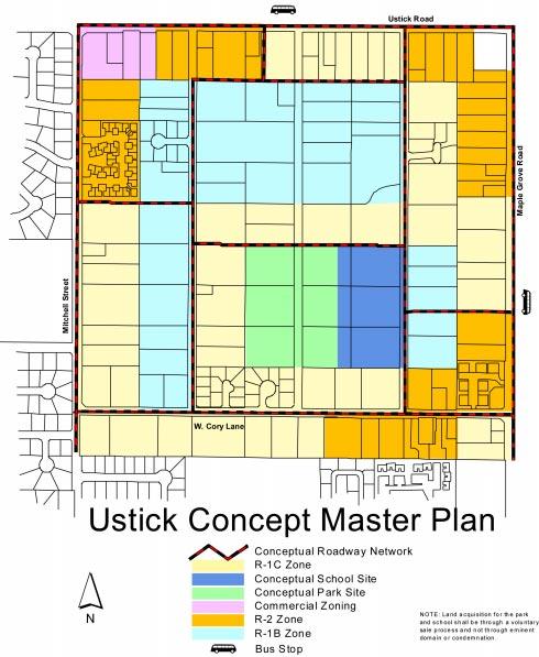
3 BOISE CITY ~ NEIGHBORHOOD MASTER PLANS GOALS, OBJECTIVES AND POLICIES GUIDING PRINCIPLES BOISE CITY COMPREHENSIVE PLAN GOALS, OBJECTIVES AND POLICIES HISTORY This neighborhood contains 130 acres of mostly two-acre lots surrounded by Ustick Road, Maple Grove Road, Cory Lane and North Mitchell Street. The area dates from 1908, when the Interurban Streetcar Company built a line along Ustick Road, connecting it with Boise and the surrounding towns. The Ustick area originally contained a number of irrigated orchards and country homes. Today, as the city grows, the area is under pressure to expand. NEIGHBORHOOD DENSITIES Neighborhood uses include residential, open space, public uses and small commercial areas within a walkable environment. The neighborhood should contain a mix of housing types, including singlefamily, duplexes, town homes and apartments. A variety of costs and ownership opportunities should be provided. Neighborhood infill would include low density zoning (R-1C) with five to seven units per acre; and high density zoning (R-2) with up to 14 units per acre. See the concept Master Plan for the general layout of zoning densities. PAGE -2 USTICK CONCEPT MASTER PLAN

4 GOALS, OBJECTIVES AND POLICIES BOISE CITY ~ NEIGHBORHOOD MASTER PLANS USTICK CONCEPT MASTER PLAN PAGE -3

5 BOISE CITY ~ NEIGHBORHOOD MASTER PLANS GOALS, OBJECTIVES AND POLICIES PARK A centrally located seven to ten acre neighborhood park would provide a public focus for the neighborhood. An additional five acres would be set aside for a future elementary school site. The park should be located next to public streets and designed for active and passive uses. This park will be constructed and designed following the policies and development criteria outlined in the City of Boise s Comprehensive Park and Recreation System Plan. Note: Land acquisition for the park and school shall be thorugh a voluntary sale process not through eminent domain or condemnation. PAGE -4 USTICK CONCEPT MASTER PLAN

6 GOALS, OBJECTIVES AND POLICIES BOISE CITY ~ NEIGHBORHOOD MASTER PLANS SCHOOL A five acre elementary school site could be located adjacent to the neighborhood park. The school and park would be connected to the neighborhood through a system of sidewalks, paths, streets, and bikeways. TRANSIT STOPS Neighborhood transit stops are located on Ustick and Maple Grove Roads connecting a citywide bus service. These bus stops are within walking distance to the neighborhood and are connected by a system of sidewalks and paths. The transit stops on Ustick and Maple Grove would have convenient pedestrian crossings, providing on-demand pedestrian activated signals. The bus stop could be enhanced by interpretive information and designs taken from the former Ustick Interurban stop. BUILDING FACADES Building facades should be varied, with building entries and windows facing the street. The use of front porches, bays and balconies is encouraged. In no case shall a facade of a building consist of an unarticulated blank wall or an unbroken series of garage doors. Primary ground floor residential entries must be oriented to streets, not to interior blocks or parking lots. Residential garages should USTICK CONCEPT MASTER PLAN PAGE -5

7 BOISE CITY ~ NEIGHBORHOOD MASTER PLANS GOALS, OBJECTIVES AND POLICIES be positioned to reduce their visual impact on the streets. Residential setback should be a minimum of 15 feet from the property line at the sidewalk. STREETS A network of collector and local streets would provide auto safety and on-street parking. Arterials (Ustick Road and Maple Grove Road) are located on the periphery of the neighborhood. Access to the arterials would be limited, with residential development utilizing interior streets to alleviate safety problems when trying to leave or enter traffic on Ustick Road or Maple Grove Road. Collector streets are designed to minimize through-trips and encourage use of periphery arterial streets. An inter-connected street system of collector and local streets serves the neighborhood. Culde-sacs are discouraged because they result in poor fire fighting equipment access, discourage pedestrian traffic and diminish neighborhood social interaction. Intersections should be designed to slow traffic and reduce pedestrian crossing distances. This can be done by constricting or minimizing the intersection dimensions or by creating a center median to constrict traffic flow at an intersection. PAGE -6 USTICK CONCEPT MASTER PLAN

8 GOALS, OBJECTIVES AND POLICIES BOISE CITY ~ NEIGHBORHOOD MASTER PLANS ALLEYS Where possible, alleys should be used to serve residential development. Alleys provide an opportunity to put the garage to the rear allowing the street to be more pedestrian friendly. Streets lined with porches, entries and living space are safer because of the visual surveillance this provides. SIDEWALKS Sidewalks, at least five feet wide, are required on all streets. Street corridors must be pedestrian friendly which will include sidewalks, street trees, street front building entries and parallel parking shelters and other enhancements of that evironment. This is a walkable neighborhood, providing access for children, the elderly, and those adults who choose to walk or bike to any location. Cory Lane would include a bike lane taking the place of on-street parking. TREES Shade trees are required along all streets. They should be located between the curb and sidewalk. Street trees enhance the quality of the neighborhood and provide relief from summer heat. USTICK CONCEPT MASTER PLAN PAGE -7
9
This chapter describes the proposed circulation system and transportation alternatives associated with
 5.0 Circulation 5.1 OVERVIEW This chapter describes the proposed circulation system and transportation alternatives associated with West Landing, and summarize the information contained in the Existing
7/23/2017 VIA . Michael Hanebutt City of Sacramento Community Development Department 300 Richards Boulevard, 3 rd Floor Sacramento, CA 95811
 7/23/2017 VIA EMAIL Michael Hanebutt City of Sacramento Community Development Department 300 Richards Boulevard, 3 rd Floor Sacramento, CA 95811 RE: 65 th Street Apartments (DR17-220) Dear Mr. Hanebutt:
5 CIRCULATION AND STREET DESIGN
 5 CIRCULATION AND STREET DESIGN This chapter describes circulation and streetscape improvements proposed for the Northwest Chico Specific Plan Area. It includes detailed design specifications for existing
Illustrated Principles of Good Planning
 Illustrated Principles of Good Planning The Miami 21 Zoning Code incorporates time-tested planning principles into the zoning regulations of our City. These are principles that make for better neighborhoods,
Report. Typical Sections. City of Middleton, WI
 Report Typical Sections City of Middleton, WI December 2006 Report for City of Middleton, Wisconsin Typical Sections repared by: Traffic Associates LLC and STRAND ASSOCIATES, INC. 910 West Wingra Drive
Arlington s Master Transportation Plan
 Arlington s Master Transportation Plan The Master Transportation Plan (MTP) Adopted in eight parts Goals & Policies element and MTP Map adopted in 2007 Bicycle, Pedestrian and Demand and Systems Management
In station areas, new pedestrian links can increase network connectivity and provide direct access to stations.
 The Last Mile Planning for Pedestrians Planning around stations will put pedestrians first. Making walking to stations safe and easy is important; walking will be a part of every rapid transit Accessible
Health and the Built Environment Presentation to the Childhood Obesity Conference
 Presentation to the Childhood Obesity Conference By Cole Runge, Principal Planner Brown County Planning Commission September 29, 2011 The built environment strongly influences physical and mental health.
Classification Criteria
 SCHEDULE D TO RECOMMENDED OFFICIAL PLAN AMENDMENT NO. 40 SCHEDULE C-4 Road Criteria Criteria Traffic Service Objective Land Service/Access Typical Daily Traffic Volume Flow characteristics Travel Speed
complete streets design and construction standards public primer City of Edmonton
 complete streets design and construction standards public primer City of Edmonton introduction Complete Streets are streets for everyone: people who walk, wheel, bike, take transit, or drive. They are
Approaches. Livable Neighborhood Design. Examples. Traditional neighborhood development. CE 594 University of Wisconsin- Milwaukee
 Approaches Livable Neighborhood Design CE 594 University of Wisconsin- Milwaukee Traditional neighborhood design (TND), new urbanism, transit friendly design, transit oriented development and walkable
How to Develop a Pedestrian Safety Action Plan
 How to Develop a Pedestrian Safety Action Plan Course Introduction Presented by: Peter Eun FHWA RC Safety Engineer Ryan Snyder President, Ryan Snyder Associates, LLC Paul Zykofsky Director, Land Use and
Solana Beach Comprehensive Active Transportation Strategy (CATS)
") Solana Beach Comprehensive Active Transportation Strategy (CATS) 3.0 Goals & Policies The Solana Beach CATS goals and objectives outlined below were largely drawn from the Solana Beach Circulation Element
Solana Beach Comprehensive Active Transportation Strategy (CATS) 3.0 Goals & Policies The Solana Beach CATS goals and objectives outlined below were largely drawn from the Solana Beach Circulation Element
Table #6 VISION CHARACTERISTICS
 Table #6 VISION White Flint is a place to live, work, play, shop, and walk with sufficient density to encourage quality redevelopment. Vibrant streets and consistent streetscapes are important. CHARACTERISTICS
Brian D. Hare, P.E. Bureau of Design PennDOT PA APA Annual Conference Investing in a Sustainable Future October 5, 2009
 Brian D. Hare, P.E. Bureau of Design PennDOT 2009 PA APA Annual Conference Investing in a Sustainable Future October 5, 2009 1 What is Smart Transportation? Photographer: heyjude. Used through license
David Hung, Associate Planner City of Sacramento Community Development Department 300 Richards Boulevard, 3 rd Floor Sacramento, CA
 June 13, 2016 VIA EMAIL David Hung, Associate Planner City of Sacramento Community Development Department 300 Richards Boulevard, 3 rd Floor Sacramento, CA 959811 RE: Fire Station 14 (DR16-128) Dear Mr.
Creating walkable, bikeable and transit-supportive communities in Halton
 Creating walkable, bikeable and transit-supportive communities in Halton By presenting current research and best practices, the information in this paper is meant to support and broaden discussion on how
GOAL 2A: ESTABLISH AND MAINTAIN A SAFE, CONVENIENT, AND EFFICIENT MULTI-MODAL TRANSPORTATION SYSTEM TO MOVE PEOPLE AND GOODS THROUGHOUT THE CITY.
 2. TRANSPORTATION ELEMENT The purpose of this element is to assist in establishing an adequate transportation system within the City and to plan for future motorized and non-motorized traffic circulation
Chapter 2: Standards for Access, Non-Motorized, and Transit
 Standards for Access, Non-Motorized, and Transit Chapter 2: Standards for Access, Non-Motorized, and Transit The Washtenaw County Access Management Plan was developed based on the analysis of existing
The Leadville Bikeway Design Recommendations DRAFT January 2018
 The Leadville Bikeway Design Recommendations DRAFT January 2018 Overview The Leadville Bikeway project aims to create a bikeway that is compatible with and adds value to the neighborhood and surrounding
Planning Regionally With Transit
 Planning Regionally With Transit Nathan Coats Director of Operations CTAA Expo 2015 Tampa Began 1992. Serves eastern Cache County to Preston, ID. Population- 115,000 34 bus fleet, 26 fixed route buses;
Vision: Traditional hamlet with an attractive business/pedestrian friendly main street connected to adjacent walkable neighborhoods
 N D. Focus Area II Vision: Traditional hamlet with an attractive business/pedestrian friendly main street connected to adjacent walkable neighborhoods Transit Road Focus Area II is located in the Hamlet
CONNECTING PEOPLE TO PLACES
 CONNECTING PEOPLE TO PLACES 82 EAST BENCH MASTER PLAN 07 Introduction The East Bench transportation system is a collection of slow moving, treelined residential streets and major arteries that are the
Chapter 5. Principles Appropriating Process
 Chapter 5 Principles Appropriating Process New, post and other urbanism [ ] However these urbanism are perceived, they do represent different values and sensibilities. They need to be situated in time
Incentive Zoning. Zoning Ordinance Advisory Committee June 21, Pam Thompson, Senior Planner, Sustainable Development and Construction
 Incentive Zoning Zoning Ordinance Advisory Committee June 21, 2018 Pam Thompson, Senior Planner, Sustainable Development and Construction Presentation Overview Stakeholder questions Updated charts Design
6/14/2013 VIA . Evan Compton, Associate Planner Community Development Department City of Sacramento 300 Richards Blvd Sacramento, CA 95814
 6/14/2013 VIA EMAIL Evan Compton, Associate Planner Community Development Department City of Sacramento 300 Richards Blvd RE: Sacramento Natural Foods Co-Op (P13-025) Dear Mr. Compton: WALKSacramento appreciates
o n - m o t o r i z e d transportation is an overlooked element that can greatly enhance the overall quality of life for the community s residents.
 N o n - m o t o r i z e d transportation is an overlooked element that can greatly enhance the overall quality of life for the community s residents. 84 Transportation CHAPTER 11 INTRODUCTION Transportation
Roadway Classification Design Standards and Policies. Pueblo, Colorado November, 2004
 Roadway Classification Design Standards and Policies Pueblo, Colorado November, 2004 Table of Contents Page Chapter 1. General Provisions 1.1 Jurisdiction 3 1.2 Purpose and Intent 3 1.3 Modification 3
Sixth Line Development - Transit Facilities Plan
 Memorandum Date: November 13, 2012 To: From: c.c. Subject: Rob Freeman (Freeman Planning) Kevin Phillips Sixth Line Development - Transit Facilities Plan 33016631 This memo was prepared to review the transit
5/31/2016 VIA . Arwen Wacht City of Sacramento Community Development Department 300 Richards Blvd., 3 rd Floor Sacramento, CA 95811
 5/31/2016 VIA EMAIL Arwen Wacht City of Sacramento Community Development Department 300 Richards Blvd., 3 rd Floor Sacramento, CA 95811 RE: El Pollo Loco (P16-028) Dear Ms. Wacht: WALKSacramento has reviewed
West Dimond Blvd Upgrade Jodhpur Street to Sand Lake Road
 West Dimond Blvd Jodhpur St to Sand Lake CSS Transportation Project Summary Municipality of Anchorage Project # 05 005 Project Manager: John Smith, P.E. (MOA PM&E) Project Administrator: Julie Makela,
MASTER BICYCLE AND PEDESTRIAN PLAN
 VILLAGE OF NORTHBROOK MASTER BICYCLE AND PEDESTRIAN PLAN DRAFT PLAN OPEN HOUSE May 2, 2018 AGENDA 1. Community Engagement 2. Vision and Goals 3. General Structure of Plan 4. Recommendations Overview 5.
Designing for Pedestrian Safety
 Designing for Pedestrian Safety Introduction to Pedestrian Safety Design and Planning Principles Presented by: Craig Allred FHWA Resource Center Technical Specialist and Michael Ronkin Owner, Designing
Implementing Complete Streets: The Road Diet. Ed McKinney, AICP Senior Associate, Glatting Jackson
 Implementing Complete Streets: The Road Diet Ed McKinney, AICP Senior Associate, Glatting Jackson How do we implement complete streets on our existing roads? Many Roads Could Use a road diet Trying to
STEERING COMMITTEE MEETING June 17, Streetscape Overview Burlington Comprehensive Master Plan
 STEERING COMMITTEE MEETING June 17, 2015 Streetscape Overview Burlington Comprehensive Master Plan 1 Introduction Slide This slide show was presented to the Burlington Steering Committee on June 17, 2015
Safe Streets. City of Lake Forest Park. March 21, 2017
 Safe Streets City of Lake Forest Park March 21, 2017 1 01 WELCOME 2 Agenda WELCOME WHAT IS THIS PROJECT? CONTEXT DRAFT CITYWIDE PROJECTS EXERCISE INTRODUCTION 3 02 WHAT IS THIS PROJECT? 4 WHAT IS THIS
Living Streets Policy
 Living Streets Policy Introduction Living streets balance the needs of motorists, bicyclists, pedestrians and transit riders in ways that promote safety and convenience, enhance community identity, create
Multimodal Through Corridors and Placemaking Corridors
 68 Multimodal Through Corridors and Placemaking Corridors Corridors have different functions in a region. Some corridors are used to get smoothly and rapidly through a region or to get quickly to major
Prince George s County plans, policies, and projects
 Prince George s County plans, policies, and projects Over 250 projects for trails, bikeways, designated bike lanes and sidewalk construction Trail projects that improve access to Metro Sidewalk and trail
Complete Streets Policy DAVID CRONIN, P.E., CITY ENGINEER
 Complete Streets Policy DAVID CRONIN, P.E., CITY ENGINEER Complete Streets City Commission adopted a Complete Streets policy in 2012 Complete Streets are road networks that are designed for all users:
and Rural Multimodal Networks 2017 ALTA PLANNING + DESIGN
 Small Town and Rural Multimodal Networks 2017 ALTA PLANNING + DESIGN SMALL TOWN AND RURAL MULTIMODAL NETWORKS GUIDE Why a Rural and Small Town Focused Guide? ONE SIZE DOES NOT FIT ALL. The new FHWA-endorsed
Chapter 7. Transportation. Transportation Road Network Plan Transit Cyclists Pedestrians Multi-Use and Equestrian Trails
 Chapter 7 Transportation Transportation Road Network Plan Transit Cyclists Pedestrians Multi-Use and Equestrian Trails 7.1 TRANSPORTATION BACKGROUND The District of Maple Ridge faces a number of unique
Omaha s Complete Streets Policy
 Omaha s Complete Streets Policy (Adopted August 2015) VISION To create great places and enhance our quality of life, the City of Omaha will provide safe, accessible streets for all users. Complete Streets
Transportation Planning Division
 Transportation Planning Division Presentation Outline Study Tasks Recap of Previous Meetings Data Collected Focus Areas within Study Limits Design Principles Tool Box Recommended Concepts Schedule Moving
9/22/2014 VIA . RE: Butano Apartments Pre App (PAMP )
") 9/22/2014 VIA EMAIL Surinder Singh, Senior Planner Planning and Environmental Review Division Sacramento County 827 7th Street, Second Floor RE: Butano Apartments Pre App (PAMP2014-00012) Dear Mr. Singh:
9/22/2014 VIA EMAIL Surinder Singh, Senior Planner Planning and Environmental Review Division Sacramento County 827 7th Street, Second Floor RE: Butano Apartments Pre App (PAMP2014-00012) Dear Mr. Singh:
4 MOBILITY PLAN. Mobility Plan Objectives. Mobility Context. 1. Integrate with Local and Regional Transit Improvements
 Harbor Mixed Use CHAPTER Transit Corridor 4: Mobility Plan 4 MOBILITY PLAN Mobility Plan Objectives The Harbor Corridor Plan seeks to expand and improve the ways that people move along and through the
This Chapter sets forth the minimum design, technical criteria and specifications to be used in the preparation of all roadway plans.
 4.1 GENERAL This Chapter sets forth the minimum design, technical criteria and specifications to be used in the preparation of all roadway plans. These Roadway Standards are for new construction and modification
A CHANGING CITY. of Edmonton, it is essential that it reflects the long-term vision of the City.
 A CHANGING CITY By the year 2040, Edmonton will be home to more than 1 million people. To accommodate growth and support a healthy and compact city, we need a new approach to development/redevelopment
Garden City State Street Corridor Existing Conditions October 2012
 Garden City State Street Corridor Existing Conditions October 2012 Prepared by Garden City Development Services Leon Letson, Missy Harris & Jenah Thornborrow 6015 Glenwood Street Garden City, Idaho 83714
2.0 Existing Conditions
 20 2.0 Existing Conditions 2.1 Land Use, Future Growth Patterns, Physical Barriers Geographic Overview Sutter County s land use pattern is characterized by extensive agricultural areas, significant natural
Giles Run Connector Road
 Giles Run Connector Road Laurel Hill Adaptive Reuse Area to Laurel Crest Drive South County Federation Meeting June 14, 2016 History Connector road included in the Laurel Hill Comprehensive Plan amendment
Prepared For: Shieldbay Developments Inc. c/o Matson, McConnell Ltd. 2430A Bloor Street West Toronto, Ontario M6S 1P9.
 Prepared For: Shieldbay Developments Inc. c/o Matson, McConnell Ltd. 2430A Bloor Street West Toronto, Ontario M6S 1P9 Prepared By: URS Canada Inc. 4 th Floor, 30 Leek Crescent Richmond Hill, Ontario L4B
Ocean Park Boulevard Green Street Project Alternatives & Trade Offs
 Planning Commission March 4, 2009 Ocean Park Boulevard Green Street Project Alternatives & Trade Offs Purpose of Tonight s Meeting Review concept plans and options Provide input on alternatives and trade-offs
10/8/2014 VIA . RE: CVS Pharmacy (P13-002) Revised August 2014
 Revised August 2014") 10/8/2014 VIA EMAIL David Hung, Associate Planner Community Development Department, Current Planning Division City of Sacramento 300 Richards Boulevard, 3 rd Floor Sacramento, CA 95811 RE: CVS Pharmacy
10/8/2014 VIA EMAIL David Hung, Associate Planner Community Development Department, Current Planning Division City of Sacramento 300 Richards Boulevard, 3 rd Floor Sacramento, CA 95811 RE: CVS Pharmacy
5 Circulation & Parking
 5 Circulation & Parking Downtown Parking & Circulation Strategy. Downtown Wayne has a somewhat disconnected system of local public streets to connect downtown with the residential neighborhoods, and primary
Planning Guidance in the 2012 AASHTO Bike Guide
 Planning Guidance in the 2012 AASHTO Bike Guide Presentation by: RJ Eldridge Peter Lagerwey August 22, 2012 WEBINAR 2: PLANNING GUIDANCE IN THE 2012 AASHTO BIKE GUIDE Today s Webinar Significant Updates
Aurora Urban Street Standards For Transit Oriented Developments and Urban Centers
 Aurora Urban Street Standards For Transit Oriented Developments and Urban Centers I. Purpose These standards will be applied to create a safe, comfortable, pleasant and pedestrian-friendly multi-modal
RIVERSIDE, Newton MA BH NORMANDY RIVERSIDE LLC. Riverside Station. A green, transit-oriented community
 Riverside Station A green, transit-oriented community October 6, 2011 TONIGHT S AGENDA: 1. Project Update (5 min.) 2. Master Plan Update (10 min.) 3.Traffic Plan Update (10 min.) Questions & Answers MASTER
11/28/2016 VIA
 11/28/2016 VIA EMAIL Ethan Meltzer, Assistant Planner City of Sacramento Community Development Department 300 Richards Blvd., 3 rd Floor Sacramento, Ca 95811 RE: Natomas Corporate Center Commercial Building
COWETA HIGH SCHOOL AND EAST HIGHWAY 51
 COWETA HIGH SCHOOL AND EAST HIGHWAY 51 Lack of sidewalks along Ben Lumpkin Rd. Lack of crosswalks and ramps at intersection. Hwy 51 is wide to cross as a pedestrian. No ADA compliance or connection to
Active Transportation Facility Glossary
 Active Transportation Facility Glossary This document defines different active transportation facilities and suggests appropriate corridor types. Click on a facility type to jump to its definition. Bike
Physical Implications of Complete Streets Policies
 Presentation Overview Physical Implications of Complete Norm Cox, ASLA, LLA Landscape Architect Ann Arbor, Michigan, 10:45 to Noon What Are Complete Streets? What Matters to Bicyclists and Pedestrians
CONTENTS INTRODUCTION... 1 PURPOSE AND SCOPE... 1 MOBILITY ELEMENT TRANSPORTATION REPORT... 2 ROADWAY COMPONENT... 3 OPPORTUNITY AREAS...
 CONTENTS INTRODUCTION... 1 PURPOSE AND SCOPE... 1 TRANSPORTATION REPORT... 2 ROADWAY COMPONENT... 3 OPPORTUNITY AREAS... 7 OTHER TRANSPORTATION MODES... 9 GOALS, POLICIES AND IMPLEMENTING ACTIONS... 13
CONTEXT SENSITIVE STREETS STANDARDS COMMITTEE
 CONTEXT SENSITIVE STREETS STANDARDS COMMITTEE February 23, 2015 Prepared by: Denise Chaplick, AICP City Jacksonville Bicycle and Pedestrian Coordinator Source: NCDOT Complete Streets Planning and Design
Non-Motorized Transportation 7-1
 Non-Motorized Transportation 7-1 Transportation facilities no longer mean just accommodating a vehicle powered by a combustion engine. Pedestrian and non-motorized facilities are important modes of travel
Tonight is for you. Learn everything you can. Share all your ideas.
 Strathcona Neighbourhood Renewal Draft Concept Design Tonight is for you. Learn everything you can. Share all your ideas. What is Neighbourhood Renewal? Creating a design with you for your neighbourhood.
Bicycle and Pedestrian Advisory Committee (BPAC) November 21, 2013
 November 21, 2013") Bicycle and Pedestrian Advisory Committee (BPAC) November 21, 2013 OVERALL LAND USE CONCEPT Overall Broadway Valdez District: 95.5 acres (35.1 acres right-of ways + 60.4 acres developable land) Plan Subareas:
Bicycle and Pedestrian Advisory Committee (BPAC) November 21, 2013 OVERALL LAND USE CONCEPT Overall Broadway Valdez District: 95.5 acres (35.1 acres right-of ways + 60.4 acres developable land) Plan Subareas:
Application of a Complete Street
 Application of a Complete Street Southbend to Prima Vista Update May 14, 2018 Meeting Agenda Perspective and History Public input received Typical sections being considered Presentation of the 2-lane master
Bristol Street Improvements Civic Center Dr. to Washington Ave. Washington Square Artesia Pilar Flower Park. Tuesday, September 27, 2016
 Street Civic Center Dr. to Washington Ave. Special Joint Neighborhoods Meeting Washington Square Artesia Pilar Flower Park Tuesday, September 27, 2016 El Salvador Recreation Center 1 Previous Informational
2. TRANSPORTATION ELEMENT.
 2. TRANSPORTATION ELEMENT. The purpose of this element is to assist in establishing an adequate transportation system within the City and to plan for future motorized and non-motorized traffic circulation
City of Gainesville Transportation/Roadway Needs PROJECT SUMMARY
 A1 Roadway Resurfacing $23,846,000 TYPE: Preservation of existing system Roadway resurfacing A2 Signal Replacement $6,000,000 TYPE: Preservation of existing system Replace traffic signals. B1 W 6th St
122 Avenue: 107 Street to Fort Road
 : 107 Street to Fort Road November 24, 2015 4:30 8:00 p.m. Meeting Purpose Summarize project work completed to date Share results of public input from Phase 1 Share the draft concept plan and proposed
12/4/2016 VIA . RE: Grocery Outlet Del Paso (DR16-328)
") 12/4/2016 VIA EMAIL Ethan Meltzer, Assistant Planner City of Sacramento Community Development Department 300 Richards Blvd, 3 rd Floor Sacramento, CA 95811 RE: Grocery Outlet Del Paso (DR16-328) Dear Mr.
12/4/2016 VIA EMAIL Ethan Meltzer, Assistant Planner City of Sacramento Community Development Department 300 Richards Blvd, 3 rd Floor Sacramento, CA 95811 RE: Grocery Outlet Del Paso (DR16-328) Dear Mr.
GIS Based Data Collection / Network Planning On a City Scale. Healthy Communities Active Transportation Workshop, Cleveland, Ohio May 10, 2011
 The Purpose of GIS Based Network Planning GIS Based Data Collection / Network Planning Healthy Communities Active Transportation Conference Tuesday, May 10, 2011 10:00 AM Norman Cox, LLA, ASLA. Ann Arbor,
Chapter Five: Transportation Plan
 Introduction Transportation and Circulation Street Sections Intersections Traffic Calming Public Transit Trails Public Landscape and Streetscape Circulation Policies September 2008 Page 5-1 Tidewater Crossing
Santa Ana Creating Community Together
 City of Santa Ana Creating Community Together Circulation & Housing Element Update Open House Thursday, May 9, 2013 1 General Plan Circulation Element Update Open House #3 2 What is a Circulation Element?
FOCUS AREA 1 - Alberta Avenue Pocket Park 3 (121 Ave and 92 St)
") FOCUS AREA 1 - Alberta Avenue Pocket Park 3 (121 Ave and 92 St) New benches Plant evergreen trees Widen existing sidewalk from 1.5m to 1.8m Marked crosswalk 1.8m wide sidewalk Add pedestrian oriented lights
FOCUS AREA 1 - Alberta Avenue Pocket Park 3 (121 Ave and 92 St) New benches Plant evergreen trees Widen existing sidewalk from 1.5m to 1.8m Marked crosswalk 1.8m wide sidewalk Add pedestrian oriented lights
FONTAINE AVENUE STUDY Final Report
 FONTAINE AVENUE STUDY Final Report March 28, 2005 FONTAINE AVENUE STUDY City of Charlottesville March 28, 2005 Renaissance Planning Group Kenneth Schwartz, FAIA, AICP Director of Design Leigh Wilkerson,
SECTION 1 - TRAFFIC PLANNING
 SECTION 1 - TRAFFIC PLANNING 1.1 TRAFFIC OPERATIONS 1.1.1 Roadway Functional Classification The Multnomah County Comprehensive Framework Plan s Policy 34: Trafficways and the Functional Classification
1 st and 2 nd Street Couplet FAQ s
 1 st and 2 nd Street Couplet FAQ s Q. Will the proposed roundabout at Flume/2nd/1 st Streets affect access to businesses nearby?... 2 Q. What if the project isn t received well by the community after construction?...
City of Wayzata Comprehensive Plan 2030 Transportation Chapter: Appendix A
 A1. Functional Classification Table A-1 illustrates the Metropolitan Council s detailed criteria established for the functional classification of roadways within the Twin Cities Metropolitan Area. Table
5/7/2013 VIA . RE: University Village Safeway Expansion (P13-019)
") 5/7/2013 VIA EMAIL David Hung, Associate Planner Community Development Department, Current Planning Division City of Sacramento 300 Richards Boulevard, 3 rd Floor Sacramento, CA 95811 RE: University Village
5/7/2013 VIA EMAIL David Hung, Associate Planner Community Development Department, Current Planning Division City of Sacramento 300 Richards Boulevard, 3 rd Floor Sacramento, CA 95811 RE: University Village
Community Open House December 13, A project of the Green Infrastructure Center, supported by Skeo Solutions
 Community Open House December 13, 2011 A project of the Green Infrastructure Center, supported by Skeo Solutions Project Background The Green Infrastructure Center, Inc. (GIC) was formed in 2006 to help
City of Seattle Edward B. Murray, Mayor
 City of Seattle Edward B. Murray, Mayor Department of Transportation Scott Kubly, Director Eastlake Community Council 117 E Louisa St. #1 Seattle, WA 98102-3278 January 28, 2016 RE: Roosevelt to Downtown
Complete Streets. Designing Streets for Everyone. Sarnia
 Complete Streets Designing Streets for Everyone Sarnia Complete Streets ~ Sarnia ~ 2018 Introduction Our City is made up of a network of streets that we use to go for a walk, cycle to work, drive to the
Welcome to the Quebec Alternatives Analysis Public Meeting
 Welcome to the Public Meeting Please sign in. Public Comment Please fill out a comment card and tell us what you think. Check back or comment any time at: www.quebecalternatives.com Project Area Technical
01. VICINITY OF GREENBRAE POC: EXISTING CONDITIONS
 01. VICINITY OF GREENBRAE POC: EXISTING CONDITIONS Existing Bus Stop Existing US101 On-ramp Existing POC Old Redwood Highway Rich Street City ROW Environmental Study Limit Industrial Way NO DESIGNATED
CHAPTER 16 PEDESTRIAN FACILITIES DESIGN AND TECHNICAL CRITERIA TABLE OF CONTENTS
 CHAPTER 16 PEDESTRIAN FACILITIES DESIGN AND TECHNICAL CRITERIA TABLE OF CONTENTS Section Title Page 16.1 General... 16-1 16.1.1 AASHTO Reference... 16-1 16.1.2 ADA Requirements... 16-1 16.2 Sidewalks...
NEWMARKET UPHAM S CORNER
 SOUTH STATION Planning Initiative NEWMARKET UPHAM S CORNER COLUMBIA ROAD (P) FOUR CORNERS/GENEVA Working Advisory Group (WAG) Meeting #5 TALBOT AVENUE MORTON STREET BLUE HILL AVE/CUMMINS HWY (P) RIVER
CITY OF ELKO BICYCLE AND PATHWAY PLAN
 CITY OF ELKO BICYCLE AND PATHWAY PLAN INTRODUCTION: The City of Elko is intended to provide the basic framework for the development of a functional bicycle and pathway system for the community with connections
Planning Study SR 976. Project Advisory Team Meeting May 24, 2017
 ` SR 976 BIRD ROAD/SW 40TH STREET FROM SR 821/HEFT TO SR 5/US-1 Miami-Dade County, Florida FPID No.: 434845-4-22-01 Planning Study Project Advisory Team Meeting May 24, 2017 1 Agenda Introductions Project
Appendix B - Street Sections
 Appendix B - Street Sections 6TH STREET CORRIDOR PLAN STREET SECTIONS The street sections in Appendix B include recommended improvements to streets for North Glenwood. They include existing conditions
TOWN OF CHAPEL HILL POLICY AND PROCEDURES FOR TRAFFIC CALMING MEASURES
 TOWN OF CHAPEL HILL POLICY AND PROCEDURES FOR TRAFFIC CALMING MEASURES (Adopted by the Town Council on June 30, 2004) (Revised December 6, 2010) (Revised February 8, 2016) POLICY AND PROCEDURES FOR TRAFFIC
3. INTERCONNECTED STREETS AND TRANSPORTATION NETWORKS
 Design Approaches 61 3. INTERCONNECTED STREETS AND TRANSPORTATION NETWORKS There are a number of different approaches to interconnect streets in neighborhoods and Development Areas. Interconnections provide
El Camino Real Specific Plan. TAC/CAC Meeting #2 Aug 1, 2018
 El Camino Real Specific Plan TAC/CAC Meeting #2 Aug 1, 2018 Land Use Alternatives Goals and Tradeoffs Parks & open space Housing Retail & services Civic spaces Parking Community gathering spaces 3 Alternatives
Ada County Highway District
 Ada County Highway District LIVABLE STREET DESIGN GUIDE ADOPTED D MAY 27, 2009 0 Committed to Service This page is intentionally left blank. TABLE OF CONTENTS 1.0 Basics of the Livable Street Design Guide
Welcome. If you have any questions or comments on the project, please contact:
 Welcome This drop-in public open house is intended to provide information about the Bay Street bike lanes project. This project proposes a dedicated cycling facility along Bay Street between Aberdeen Avenue
Obey Creek PEDESTRIAN CIRCULATION EAST WEST PARTNERS PEDESTRIAN CIRCULATION CREEK SIDE LANE SLIP STREET SCOTT MURRAY MAIN STREETS EAST/WEST
 THE VILLAGE AT PEDESTRIAN CIRCULATION MAIN STREETS NORTH/SOUTH MAIN STREETS EAST/WEST SLIP STREET CREEK SIDE LANE PEDESTRIAN CIRCULATION DESCRIPTION: Circulation through the downtown of is organized by
Plant City Walk-Bike Plan
 Plant City Walk-Bike Plan Plant City Commute Mode Share 2.2% 1.4% 2.9% Drove alone 10.2% Carpooled Public transportation (0.1%) Walked Used a Bike (0.4%) 82.9% Taxicab, motorcycle, or other means Worked
Stakeholder Meeting Handouts. January 2013
 January 2013 Stakeholder Meeting Handouts The Case FOR Parking Minimum Requirements Reduce street congestion around the development site Avoid parking spillover Create orderly development patterns Anticipate