AGENDA ITEM SUMMARY SPECIAL AGENDA ITEM NO. _1A_
|
|
|
- Beverly Henry
- 5 years ago
- Views:
Transcription

 and")
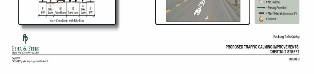
1 AGENDA ITEM SUMMARY AGENCY: City Council MEETING DATE: June 25, 2012 DEPARTMENT: Community Dev PREPARED BY: T Spade DEPT. DIR. APPROVAL: MJ CITY MGR. APPROVAL: LR PRESENTED BY: T Spade TITLE: RECEIVE REPORT AND PROVIDE DIRECTION TO STAFF AND CONSULTANT REGARDING CITY OF FORT BRAGG CHESTNUT STREET CORRIDOR CONCEPTUAL PLAN AND RIGHT OF WAY ACQUISITION FEASIBILITY STUDY ISSUE: Chestnut Street, a very busy major collector roadway leading to Fort Bragg High School, the C.V. Starr Community Center, two elementary schools and a large residential area, was studied by Fehr & Peers as one of the four focal roadways in the 2010 Residential Streets Safety Plan (2010 RSSP) and a conceptual plan for traffic calming and enhanced bike/pedestrian infrastructure was developed (see Figure 1). Because of Chestnut Street s level of use and importance in accessing neighborhoods, recreational facilities and schools, City Council directed staff to further develop the Chestnut Street conceptual plan from the 2010 Residential Streets Safety Plan by obtaining additional community input and investigating the feasibility of conceptual plan implementation. The additional effort was requested in order to obtain community input regarding the level of support for: 1) the potential elimination of on-street parking in order to facilitate enhanced pedestrian/bike infrastructure; and 2) the feasibility of acquiring an additional 8 feet of right of way, to allow for the retention of parking while accomplishing pedestrian and bicycle safety goals. A request for proposals was released in February of 2012 and KASL Engineering was selected as the consultant in April of Green Valley Engineering was subcontracted for the public outreach effort, and Cliff Zimmerman was subcontracted for right of way research and land survey services. The Scope of Work is included as Attachment 1. Engineering Work to Date In May of 2012, the existing legal limits of the right of way were surveyed, and detailed maps were produced, showing the location of sidewalks, telephone poles, fences, driveways and structures etc. near the corridor (Attachment 2). Numerous corridor alternatives were produced (Figure 2), and vetted by Public Works and Community Development staff. Three options were selected to present at the public outreach meeting. The three options are superimposed on the existing corridor maps, and constraints associated with each option are called out (Attachment 3). At staff's request, KASL prepared one additional corridor option for the outreach event and it is included in Attachment 3 as option 2D. SPECIAL AGENDA ITEM NO. _1A_


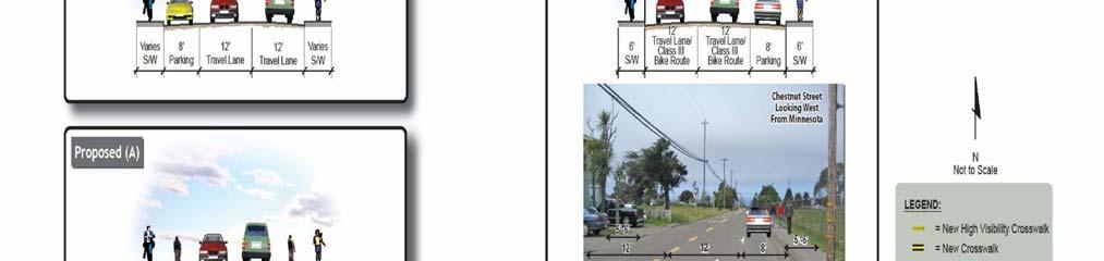
2 Figure 1. Corridor options from the 2010 Residential Street Safety Plan. Page 2
3 Figure 2. Preliminary corridor options. RECOMMENDED ACTION: Provide direction to staff and consultant regarding City Of Fort Bragg Chestnut Street Corridor Conceptual Plan and Right Of Way Acquisition Feasibility Study. ALTERNATIVE ACTION(S): None ANALYSIS: Outreach Summary The public outreach was subcontracted by KASL to Green Valley Engineers. The outreach event on June 8, 2012, 5:30pm, at the John Diederich Center, was advertised in the newspaper, a press release went out two weeks in advance, flyers were sent home with Redwood and Dana Gray students, an was sent to Fort Bragg High School parents, a Facebook page was created, and Green Valley staff sent postcard mailers to residents of the Chestnut Street neighborhood, and went door to door at and around Chestnut Street handing out flyers and asking residents to fill out a survey. Page 3
4 Public Meeting Approximately 50 people attended the public meeting, 27 of whom signed in. Liz Ellis and an associate from Green Valley Consulting, Police Sergeant Brandon Lee, Assistant Planner Teresa Spade and Jack Scroggs from KASL sat on the panel. Liz introduced the event, providing background information, and encouraged the attendants to provide feedback and suggestions. Most participants were project area residents (as noted in the sign-in sheet). A few of the attendees were parents of school age children who regularly use Chestnut Street as part of their home to school commute. Participants indicated that Chestnut Street needs improved pedestrian walkways and traffic calming measures. Participants were in favor of: Wider sidewalks (or other suitable, wider, pedestrian paths); Adding stop signs, enhanced crosswalks and speed tables (raised crosswalks) on Chestnut Street to reduce speed; Adding ADA compliant features such as ramps; and Sgt. Lee recommended additional electronic speed advisory signs. Currently, eastbound Chestnut Street vehicles are advised of speeds in the vicinity of the Redwood and Dana Gray Schools. Some attendants indicated there were no sidewalks in their area of Chestnut Street. There was general agreement that sidewalks must be accessible to everyone. Participants recommended that future Chestnut Street sidewalk improvements be focused on the north side of the street. Along the south side participants encouraged the City to work with PG&E to remove / relocate power poles and guide poles which now block / hinder the pedestrian path of trail. Minimum ADA requirements were reviewed for the existing walkways along the south side of the street. There were several people that requested wider sidewalks. There was support for a multi-use trail on the north side. One person commented that when they bike to school with their kids, they avoid all the streets with bike lanes if the streets have bike lanes they are too wide and cars go too fast. Participants agreed that: A safe route to school currently does not exist on Chestnut Street The do-nothing alternative is not acceptable Participants expressed mixed levels of support for removal of on-street parking, right of way acquisition, and conversion of Chestnut Street to a one-way street. A comment was made early on that if Chestnut Street parking is decreased, safety will increase. Comments later indicated that the 25 foot red zones at intersections need to be extended to increase sight distance. About 50% of the attendants were okay with seeing on-street parking eliminated. Some may have problems related to the removal of parking. For example, one participant indicated that they would have a tough time losing on-street parking as they do not have enough space on their parcel to park two cars. A disabled resident of Chestnut will have accessibility issues because she does not have a driveway, alley or garage, and parks on the street to get to her house. A third resident has no parking on her property for her guests when they visit. Conversion of a portion of Chestnut Street to one-way (Whipple to Lincoln) was also received Page 4
5 with mixed reviews. Many of the Chestnut Street residents were in favor of the one-way street conversion as this measure could reduce Chestnut Street traffic volumes. Staff was asked to evaluate one-way westbound as well as a one-way east bound conversion. Making Chestnut Street one-way eastbound received about 30% support, and one or two thought it would make more sense for a one-way westbound corridor. Residents are reluctant to give up personal property for new right of way but are willing to consider limited (1 to 2 foot) right of way acquisition by the City. Residents wanted to be assured that giving up their personal property would not result in costs to them nor would it place the travel way closer to their homes. Additional right of way to provide for wider walkways may be acceptable, while additional right of way for wider vehicle lanes or for vehicles traveling closer to their homes was not acceptable. There was consensus that people drive too fast, and that it is not safe to walk or bike on this street. The school busses fly by small children walking on the street, people speed through at all hours of the night, and after football games. Suggestions to improve conditions included re-routing school busses, ticketing drivers using cell phones, a stop sign at Corry, teaching kids where to walk, teaching kids to use a different route, and generally adding more stop Figure 3. Online survey. signs. Fifty percent of attendants would like to see high visibility crosswalks, and 50% would like to see speed tables. Only 3% want to see bulb outs, and no one wants beeping crosswalks. Another consideration was to add another lane at the end of Maple, to make that a useable alternative route traffic gets backed up there. Fifty percent agreed that increasing the use of Maple would be good. Another comment was that a 4-way stop is needed at Franklin and Maple. There was some discussion regarding the number of parents bringing kids to school when there are school busses, and if that number could be reduced by providing more bus service or improving safety for kids. After the public forum portion of the meeting, approximately half of the participants remained to discuss preliminary Chestnut Street alternatives one-on-one with City staff and consultants and to evaluate how implementation of Page 5
6 each alternative would impact their property. Survey Responses The City conducted a survey to gain input from people who might not be able to come to the public meeting. A summary of survey results, follows: Staff received 37 surveys in which respondents had an opportunity to rank the following items in terms of importance: bicycle lanes, sidewalks, on-street parking, traffic calming, improve pavement quality, traffic lights, and other (please specify). The survey also asks for additional fill in the blank type information. A copy of the survey is shown as Figure 3. Not everyone ranked the items. The ranking effort indicates that improvement of sidewalks and traffic calming are the most important priorities of the survey participants. Bicycle accommodation also ranked as an important priority. Although a couple participants viewed retention of on-street parking as the most important, significantly more respondents listed retention of on-street parking as less important to the least important. Installation of more traffic lights and pavement improvements were neither very important nor the least important items. Written comments were reviewed and compiled and also indicate a strong desire for wider sidewalks and safe bicycle access, as well as traffic calming. Many comments reflected a desire to widen sidewalks and remove poles and other structures that block access along the sidewalks. A strong interest was also expressed in providing for safe bicycle access, and support was given to the multi-use trail option to achieve this goal. Traffic calming was a common topic, although written comments varied on how to achieve calming. Ideas included more stop signs, traffic lights, bulb outs, no bulb outs, and chicanes rather than bulb outs. Comments indicated a desire to remove parking in order to facilitate safety improvements and improve sight distance, however there was a question about how this would impact disabled persons, and some are against removal of parking. Some interest was expressed in a one way option, with eastward being the popular direction, although some think westward may work better. Some like the one-way option because it would alleviate congestion on Chestnut Street, and others like the option because it would allow for retention of parking. Staff would like to obtain additional input from the Spanish speaking community and is circulating a Spanish version of the online survey. The survey should run through the end of June. Additional outreach efforts include summarization of follow-up comments received via Facebook and any additional online surveys received. Right of Way Acquisition Obtaining additional right of way would be an extensive undertaking because many participants are opposed to the idea, or supportive only if it involves a small one to two foot acquisition. Expanding the roadway beyond the existing 40 foot right of way which constrains more than half the corridor would impact 41 properties, and at least two residential garages would have to be moved. For this reason, Staff and the consultants focused the design efforts on options that require little to no new right of way acquisition. Preferred Design Options Page 6
7 The preferred current designs (Option 3 and Option 4, included as Attachment 4) feature a multiuse path on the north side of the corridor. Option 3 features a one-way street and parking in the constrained portion of the corridor, where the City is limited to 40 feet of right of way (Whipple to Sanderson). Option 4 allows for 2-way vehicular traffic, and eliminates on-street parking for the constrained portion of the corridor. The multi-use path is present in both options, and allows for safer bicycle use by getting cyclists, especially young children, off the street, and doubles as a wide walkway on the side of the street adjacent to schools. The proposed design also includes a narrower roadway and improvements to the sidewalk on the south side to meet ADA standards. Parking would be eliminated within the constrained middle section of the corridor (from Whipple to Sanderson) for the two-way option, but parking could be retained if the one-way option is selected. Consideration of the one-way option would require further engineering studies not covered by the scope of this project. Of concern would be additional traffic which would pass in front of Redwood School, and would be conveyed to other un-studied areas. The preferred design options are responsive to public input, prioritizing sidewalks, safe bicycle facilities, and preserving parking where feasible without additional right of way acquisition. Traffic calming is achieved by narrower roadway widths. The community supported raised speed tables and high visibility crosswalks as the best traffic calming options for the corridor. These options could be incorporated into the roadway design at key locations to further promote traffic calming. Staff is seeking specific direction from City Council on the following items: 1. Please provide direction on preferred design options (see Attachment 4); 2. Please provide feedback on revised direction of design (to a smaller corridor width than considered in the 2010 RSSP); and 3. Please provide direction on any additional items that should be considered by staff and/or the consultant. FISCAL IMPACT: This project is funded with a Mendocino Council of Governments (MCOG) grant and the funding covers both consultant costs and staff time. Project implementation may be covered with a combination of grants, general fund revenues and the street sales tax. IMPLEMENTATION/TIMEFRAMES: A final recommendation and report will be brought forward to City Council within the next two months and will incorporate input from tonight s Council meeting. Funding will need to be acquired for the design, engineering and construction of the project once a conceptual design is approved by City Council. Page 7
8 ATTACHMENTS: 1. Scope of Work 2. Detailed Corridor Map 3. Options Presented at Outreach Meeting 4. Revised Options for a Constrained Corridor NOTIFICATION: 1. KASL, Jack Scroggs 2. Green Valley Engineers, Liz Ellis 3. Workshop attendees (via ) City Clerk s Office Use Only Agency Action Approved Denied Approved as Amended Resolution No.: Ordinance No.: Moved by: Seconded by: Vote: Deferred/Continued to meeting of: Referred to: Page 8
Municipal Class EA To Address Traffic Congestion On The Ontario Street Corridor (Grand Bend) Public Information Meeting June 4, 2018
 Public Information Meeting June 4, 2018") Municipal Class EA To Address Traffic Congestion On The Ontario Street Corridor (Grand Bend) Public Information Meeting June 4, 2018 Background Agenda Traffic Study Update Class EA Alternatives Bridge
Municipal Class EA To Address Traffic Congestion On The Ontario Street Corridor (Grand Bend) Public Information Meeting June 4, 2018 Background Agenda Traffic Study Update Class EA Alternatives Bridge
Public Information Centre
 WELCOME Public Information Centre Father Tobin Road Lougheed Middle School - Library Wednesday November 7, 2012 7:00 p.m.to 9:00 p.m. Please sign in Neighbourhood Traffic Calming Guide Background The City
Monroe Street Reconstruction
 Total participants: 45+ Monroe Street Reconstruction Cross Section Workshop Notes September 29, 2016, Wingra School Workshop Orientation, Technical and Functional Considerations: The workshop began with
Item No. 14 Town of Atherton
 Item No. 14 Town of Atherton CITY COUNCIL STAFF REPORT CONSENT AGENDA TO: THROUGH: FROM: HONORABLE MAYOR AND CITY COUNCIL GEORGE RODERICKS, CITY MANAGER MICHAEL KASHIWAGI, COMMUNITY SERVICES DIRECTOR MARTY
Lee s Summit Road Improvement Study Public Open House June 7, 2007 Summary of Comment Card Responses
 Lee s Summit Road Improvement Study Public Open House June 7, 2007 Summary of Comment Card Responses Introduction At the Lee s Summit Road Improvement Study Public Open House held Thursday, June 7, 2007
2014/2015 BIKE ROUTE PLAN 83 AVENUE PROTECTED BIKE LANE
 About the Project 2014/2015 BIKE ROUTE PLAN The City of Edmonton is planning a major bike route on the south side of Edmonton. This bike route is one part of a plan to provide citizens with transportation
Saskatchewan Drive Roadway Rehabilitation and Shared-Use Path Widening
 Saskatchewan Drive Roadway Rehabilitation and Shared-Use Path Widening We are here today to present the draft plan for the Saskatchewan Drive Roadway Rehabilitation and Shared-Use Path Widening project
City of Davis East Covell Corridor Plan
 Community Open House #2 January 22, 2014 6:00 8:00 p.m. Veterans Memorial Center, Club Room City of Davis Introduction The (ECCP) is a taking a comprehensive look at the existing transportation systems
City of Fort Bragg 2011 RESIDENTIAL STREETS SAFETY PLAN. Prepared by: Chris Carterette, AICP Fort Bragg Community Development Department
 City of Fort Bragg 2011 RESIDENTIAL STREETS SAFETY PLAN Prepared by: Chris Carterette, AICP Fort Bragg Community Development Department Fehr & Peers, Transportation Consultants With funding from: Mendocino
Tonight is for you. Learn everything you can. Share all your ideas.
 Strathcona Neighbourhood Renewal Draft Concept Design Tonight is for you. Learn everything you can. Share all your ideas. What is Neighbourhood Renewal? Creating a design with you for your neighbourhood.
2014/2015 BIKE ROUTE PLAN 83 AVENUE PROTECTED BIKE LANE
 About the Project The City of Edmonton is planning a major bike route on the southside of Edmonton. The Strathcona Bike Route will connect the communities of Strathcona, Garneau and the University area,
WELCOME Public Information Centre
 WELCOME Public Information Centre Fernforest Drive Brampton Soccer Centre Community Room #2 Tuesday January 19, 2016 6:30 p.m.to 9:00 p.m. Please sign in Neighbourhood Traffic Calming Guide Background
Final Sidewalk Feasibility Study
 Garfield Drive From Anastasia Drive to Elizabeth Place City of South Daytona July 23, 2009 Final Sidewalk Feasibility Study Prepared for: Prepared by: Final Sidewalk Feasibility Study Garfield Drive 2
TRAFFIC ACTION PLAN. Laurie Meadows Neighborhood CITY OF SAN MATEO
 TRAFFIC ACTION PLAN Laurie Meadows Neighborhood CITY OF SAN MATEO Draft January 2017 Table of Contents Introduction... 2 The Traffic Forum Process... 5 Neighborhood Traffic Issues... 7 Neighborhood Recommendations
HARRISON STREET/OAKLAND AVENUE COMMUNITY TRANSPORTATION PLAN
 HARRISON STREET/OAKLAND AVENUE Community Workshop #4: Draft Plan Review December 3, 2009 D E S I G N, C O M M U N I T Y & E N V I R O N M E N T INTRODUCTIONS Key Project Staff: Alisa Shen, Project Manager,
BETHEL ROAD AND SEDGWICK ROAD CORRIDOR STUDY
 DRAFT PLAN City Council Meeting August 14, 2017 STUDY AREA Sedgwick Corridor State Route 160, principal arterial with Class 3 access management designation, commuter and freight route, connection to SR
Commercial-Vista Corridor Plan Project Management Team. Judith Johnduff, AICP, Associate Transportation Planner Public Works Department
 MEMO TO: Commercial-Vista Corridor Plan Project Management Team FROM: DATE: June 1, 2015 Judith Johnduff, AICP, Associate Transportation Planner Public Works Department SUBJECT: Public Events #2 - Summary
Third Street Bridge & Corridor Project
 Third Street Bridge & Corridor Project Preparation for the FY2018 budget to commence October 1, 2017, includes funding to address a project that has been considered since 1994. The Third Street bridge
Governance and Priorities Committee Report For the July 2, 2015 Meeting
 CITY OF VICTORIA For the July 2, 2015 Meeting To: Governance and Priorities Committee Date: From: Subject: Brad Dellebuur, A/Assistant Director, Transportation and Parking Services Executive Summary The
About the Studio. Edward J. Bloustein School of Planning and Public Policy - Rutgers University
 About the Studio Edward J. Bloustein School of Planning and Public Policy - Rutgers University Purpose of studio: Help City of Bayonne apply for Safe Routes to School (SRTS) funding by producing a School
122 Avenue: 107 Street to Fort Road
 : 107 Street to Fort Road November 24, 2015 4:30 8:00 p.m. Meeting Purpose Summarize project work completed to date Share results of public input from Phase 1 Share the draft concept plan and proposed
Non-Motorized Transportation 7-1
 Non-Motorized Transportation 7-1 Transportation facilities no longer mean just accommodating a vehicle powered by a combustion engine. Pedestrian and non-motorized facilities are important modes of travel
AGENDA REPORT. Issue: Discussion of potential improvements on Barnwell Road at Niblick Drive
 AGENDA REPORT To: From: By: Honorable Mayor and City Council Members Warren Hutmacher, City Manager Tom Black, Public Works Director Date: March 23, 2016 Agenda: March 28, 2016 WORK SESSION AGENDA: Barnwell
CITY OF LOS ANGELES INTER-DEPARTMENTAL MEMORANDUM
 CITY OF LOS ANGELES INTER-DEPARTMENTAL MEMORANDUM Date: April 1, 219 To: Honorable City Council c/o City Clerk, Room 395, City Hall Attention: Honorable Mike Bonin, Chair, Transportation Committee From:
Pedestrian, Bicycle and Traffic Calming Strategic Implementation Plan. January 18, 2011
 Pedestrian, Bicycle and Traffic Calming Strategic Implementation Plan January 18, 2011 Tonight s Agenda Receive update on project Provide feedback on two policy issues Complete Streets Policy Project Prioritization
PEDESTRIAN ACTION PLAN
 ATTACHMENT 2 CITY OF SANTA MONICA PEDESTRIAN ACTION PLAN CITY OF SANTA MONICA PEDESTRIAN ACTION PLAN This page intentionally left blank EXECUTIVE SUMMARY CHAPTER 1 EXECUTIVE SUMMARY Setting the Stage
SAFE ROUTES TO SCHOOL (SR2S)
") SAFE ROUTES TO SCHOOL (SR2S) In partnership with Burbank Unified School District (BUSD) & City of Burbank George Washington Elementary School Thomas Jefferson Elementary School John Muir Middle School
SAFE ROUTES TO SCHOOL (SR2S) In partnership with Burbank Unified School District (BUSD) & City of Burbank George Washington Elementary School Thomas Jefferson Elementary School John Muir Middle School
10A. DATE: October 5, Pedestrian and Bicycle Advisory Committee. Kevin Colin, Deputy Planning Manager Curt Bates, City Engineer
 10A DATE: October 5, 2016 TO: PREPARED BY: SUBJECT: Pedestrian and Bicycle Advisory Committee Kevin Colin, Deputy Planning Manager Curt Bates, City Engineer Discussion and Provide Comments, Associated
COMMUNITY MEETING AGENDA
 COMMUNITY MEETING AGENDA Welcome and Introductions SAFE Presentation Project Presentation Priorities Feedback Next Steps Q&A Santa Cruz Avenue Corridor Study 1 Santa Cruz Avenue Corridor Study Community
Report Purpose To seek Council s approval of the Wye Road Functional Planning Study (January 2015).
.") COUNCIL MEETING Meeting Date: March 10, 2015 Agenda Item #: 13.1 Wye Road Functional Planning Study (January 2015) Report Purpose To seek Council s approval of the Wye Road Functional Planning Study (January
COUNCIL MEETING Meeting Date: March 10, 2015 Agenda Item #: 13.1 Wye Road Functional Planning Study (January 2015) Report Purpose To seek Council s approval of the Wye Road Functional Planning Study (January
Minutes of the regular meeting of the City of Birmingham Multi-Modal Transportation Board held June 19, 2014.
 CITY OF BIRMINGHAM START-UP MEETING OF THE MULTI-MODAL TRANSPORTATION BOARD THURSDAY, JUNE 19, 2014 City Commission Room 151 Martin Street, Birmingham, Michigan Minutes of the regular meeting of the City
Scarlett Road Bridge & Road Improvements Lambton Park Community School - Gymnasium Tuesday November 28 th, 2017
 Scarlett Road Bridge & Road Improvements Lambton Park Community School - Gymnasium Tuesday November 28 th, 2017 PROJECT LOCATION 2 SCARLETT ROAD BRIDGE Constructed in 1912, the bridge carries 4 active
City of Wilsonville 5 th Street to Kinsman Road Extension Project
 City of Wilsonville 5 th Street to Kinsman Road Walking Tour & Neighborhood Workshop Summary Report Public Outreach Overview On July 18 th, 2017, the City of Wilsonville hosted a neighborhood walking tour
City of Novi Non-Motorized Master Plan 2011 Executive Summary
 City of Novi Non-Motorized Master Plan 2011 Executive Summary Prepared by: February 28, 2011 Why Plan? Encouraging healthy, active lifestyles through pathway and sidewalk connectivity has been a focus
Moving Ahead. (Community Engagement) Chapter Three
 Chapter Three") 3 Community Chapter Three Moving Ahead (Community Engagement) engagement provided an exciting opportunity to engage Redwood City residents, workers, and business owners people who walk, bike, take transit,
3 Community Chapter Three Moving Ahead (Community Engagement) engagement provided an exciting opportunity to engage Redwood City residents, workers, and business owners people who walk, bike, take transit,
Exhibit 1 PLANNING COMMISSION AGENDA ITEM
 Exhibit 1 PLANNING COMMISSION AGENDA ITEM Project Name: Grand Junction Circulation Plan Grand Junction Complete Streets Policy Applicant: City of Grand Junction Representative: David Thornton Address:
Lynchburg District Update
 Lynchburg District Update Virginia Statewide Bicycle and Pedestrian Advisory Committee Spring Meeting May 16 th, 2017 David Cook Transportation Planner, VDOT Lynchburg District Table of Contents Active
CITY OF SAINT JOHN TRAFFIC CALMING POLICY
 CITY OF SAINT JOHN TRAFFIC CALMING POLICY VERSION: 1.0 April 10, 2012 Pedestrians, Cyclists and Motorists Sharing Street Spaces CONTENTS INTRODUCTION... 3 POLICY GOAL... 3 POLICY OBJECTIVES... 3 GUIDING
EXECUTIVE SUMMARY. Vision
 Vision Walking and bicycling in Salt Lake City will be safe, convenient, comfortable, and viable transportation options that connect people to places, foster recreational and economic development opportunities,
Community Transportation Plan
 Community Transportation Plan Appendix A: Traffic Calming CITY OF DECATUR COMMUNITY TRANSPORTATION PLAN Appendix A: City of Decatur City-wide Residential Traffic Calming Program Process & Procedures The
CITY OF OTTAWA ROADWAY MODIFICATION APPROVAL UNDER DELEGATED AUTHORITY
 RMA-2015-ATM-038 CITY OF OTTAWA ROADWAY MODIFICATION APPROVAL UNDER DELEGATED AUTHORITY DATE: April 22, 2015 SUBJECT Approval of Roadway Modifications Recommended through an Area Traffic Management Study
River Road - Proposed Road Safety Enhancement Measures
 City of Richmond Report to Committee To: From: Re: Public Works and Transportation Committee Victor Wei, P. Eng. Director, Transportation Date: June 6, 2017 River Road - Proposed Road Safety Enhancement
CONNECTING PEOPLE TO PLACES
 CONNECTING PEOPLE TO PLACES 82 EAST BENCH MASTER PLAN 07 Introduction The East Bench transportation system is a collection of slow moving, treelined residential streets and major arteries that are the
Bikeway action plan. Bicycle Friendly Community Workshop March 5, 2007 Rochester, MN
 Bikeway action plan Summary The was held on March 5, 2007 at the Rochester Mayo Civic Center. The workshop was hosted by Rochester-Olmsted County Planning Department in collaboration with the League of
Edenbrook Hill Drive Traffic Calming Study
 WELCOME Public Information Centre Edenbrook Hill Drive Traffic Calming Study Fletchers Meadow Secondary School Wednesday January 20, 2016 6:30 p.m.to 9:00 p.m. Please sign in Neighbourhood Traffic Calming
Safe Streets. City of Lake Forest Park. March 21, 2017
 Safe Streets City of Lake Forest Park March 21, 2017 1 01 WELCOME 2 Agenda WELCOME WHAT IS THIS PROJECT? CONTEXT DRAFT CITYWIDE PROJECTS EXERCISE INTRODUCTION 3 02 WHAT IS THIS PROJECT? 4 WHAT IS THIS
Corporate. Report COUNCIL DATE: May 25, 1998 NO: R1500 REGULAR COUNCIL. TO: Mayor & Council DATE: April 27, 1998
 R1500 : Traffic Safety at 25 Avenue and 128 Street Intersection Corporate NO: R1500 Report COUNCIL DATE: May 25, 1998 REGULAR COUNCIL TO: Mayor & Council DATE: April 27, 1998 FROM: General Manager, Engineering
Granger Ave from State to Packard Pilot On Street Parking and Pavement Marking Discussion Summary and Feedback Reponses
 Date: Tuesday, July 25, 2018 Time: 6:00 p.m. to 7:30 p.m. Location: Ann Arbor Senior Center (1320 Baldwin Ave) Attendees: Public present: 13; refer to Appendix B for sign in sheet Council members present:
NEIGHBOURHOOD TRAFFIC COMMITTEE POLICY AND PROCEDURE
 The City of Vaughan 2141 Major Mackenzie Drive Vaughan, Ontario Canada L6A 1T1 Tel (905) 832-2281 NEIGHBOURHOOD TRAFFIC COMMITTEE POLICY AND PROCEDURE REVISED JUNE 2010 APPLICABILITY The Neighbourhood
Improvements Infrastructure Gap Assessment and Improvements Street Striping
 Infrastructure Project Proposal The federal-aid Safe Routes to School program funds infrastructure/engineering projects that fall into two categories: Design (available only to School Development Authority
SAN FRANCISCO MUNICIPAL TRANSPORTATION AGENCY
 THIS PRINT COVERS CALENDAR ITEM NO. : 10.2 DIVISION: Sustainable Streets BRIEF DESCRIPTION: SAN FRANCISCO MUNICIPAL TRANSPORTATION AGENCY Adopting Conceptual Proposal for Streetscape Improvements to Broadway,
Main-McVay Transit Study: Phase 2 Options Definition and High Level Constraints Evaluation
 Main-McVay Transit Study: Phase 2 Options Definition and High Level Constraints Evaluation APRIL 2016 A collaborative study between: For Additional Information or to Comment If you would like additional
Bay to Bay Boulevard Complete Streets Project
 Bay to Bay Boulevard Complete Streets Project Dale Mabry Highway to Bayshore Boulevard February 08, 2018 Photo Source: Tampa Bay Times Alessandra Da Pra Meeting Format Introduction Resurfacing Information
Building Great Neighbourhoods BELLEVUE AND VIRGINIA PARK
 Building Great Neighbourhoods BELLEVUE AND VIRGINIA PARK This is Meeting 2 Unfortunately, some residents in Bellevue and Virginia Park received the wrong information for this public open house (Meeting
2018 Pedestrian and Bicycle and Safe Routes to School Application for Funding Page 1 of 31
 2018 Pedestrian and Bicycle and Safe Routes to School Application for Funding Page 1 of 31 2018 Pedestrian and Bicycle and Safe Routes to School Application for Funding Part 1: General Information Funding
State Street and Pierce Park Lane Intersection Concept Report
 State Street and Pierce Park Lane Intersection Prepared for September 2017 Prepared by CITATION Parametrix. 2017. State Street & Pierce Park Lane Intersection. Prepared by Parametrix, Boise, ID. September
TRAFFIC ACTION PLAN. North Central Neighborhood CITY OF SAN MATEO
 TRAFFIC ACTION PLAN North Central Neighborhood CITY OF SAN MATEO Draft February 2017 Table of Contents Introduction... 1 The Traffic Forum Process... 4 Neighborhood Traffic Issues... 6 Neighborhood Recommendations
Outreach Approach RENEW SF served as the primary liaison with the North Beach community; the Chinatown. Executive Summary
 Executive Summary Executive Summary The Columbus Avenue Neighborhood Transportation Study s objective is to identify changes to transportation infrastructure and policies that could enhance the livability
El Paso County 2040 Major Transportation Corridors Plan
 El Paso County 2040 Major Transportation Corridors Plan Connect-our-County Online Transportation User Survey Preliminary Results June 24, 2010 Years of Residence 2. How many years have you LIVED HERE?
Americans with Disabilities Act Transition Plan for Public Right-of-Way Improvements
 Americans with Disabilities Act Transition Plan for Public Right-of-Way Improvements Prepared by: Public Works Department Engineering Division October 2015 Table of Contents Section I Introduction.. 3
Improving Cyclist Safety at the Dundas Street West and Sterling Road Intersection
 STAFF REPORT ACTION REQUIRED Improving Cyclist Safety at the Dundas Street West and Sterling Road Intersection Date: August 17, 2012 To: From: Wards: Reference Number: Public Works and Infrastructure Committee
Byron Avenue. Public Meeting. Thursday June 16, Traffic Calming Design Sherbourne Road to Island Park Drive
 Byron Avenue Traffic Calming Design Sherbourne Road to Island Park Drive Public Meeting Thursday June 16, 2016 Our Lady of Fatima Parish 153 Woodroffe Avenue 6 9pm 1 Project Summary Area Projects Background
Application of a Complete Street
 Application of a Complete Street Southbend to Prima Vista Update May 14, 2018 Meeting Agenda Perspective and History Public input received Typical sections being considered Presentation of the 2-lane master
Chapter 3: Multi-Modal Circulation and Streetscapes
 CHAPTER 3: MULTI-MODAL CIRCULATION AND STREETSCAPES Chapter 3: Multi-Modal Circulation and Streetscapes Overview Streetscape improvements have already been completed for Depot Street between Main Avenue
June 29, Dear Mr. Walter:
 From: CountyBoard@arlingtonva.us To: chickandsandy@msn.com Subject: County Board Response Regarding the Arlington Ridge Road Improvement Project (Intranet Quorum IMA00252707) Date: Wed, 29 Jun 2011 08:09:53-0400
TRAFFIC CALMING GUIDE FOR TORONTO CITY OF TORONTO TRANSPORTATION SERVICES DIVISION
 TRAFFIC CALMING GUIDE FOR TORONTO CITY OF TORONTO TRANSPORTATION SERVICES DIVISION CITY OF TORONTO TRANSPORTATION SERVICES DIVISION 2016 TRAFFIC CALMING GUIDE FOR TORONTO TABLE OF CONTENTS Introduction
Traffic Calming Policy
 City of Friendswood Traffic Calming Policy May 2012 Community Development Department Table of Contents Title Page Table of contents... 1 Background and History... 2 Purpose and Goals... 2 City Procedure
RESIDENTIAL TRAFFIC CALMING PROGRAM
 RESIDENTIAL TRAFFIC CALMING PROGRAM CITY OF ALEXANDRIA, KENTUCKY Prepared For: Safety & Public Works Departments 1 Table of Contents CITY OF ALEXANDRIA... 3 RESIDENTIAL TRAFFIC CALMING PROGRAM... 3 INTRODUCTION...
ACTIVE TRANSPORTATION
 ACTIVE TRANSPORTATION Mobility 2040 Supported Goals Improve the availability of transportation options for people and goods. Support travel efficiency measures and system enhancements targeted at congestion
DRAFT. A fifth objective, other considerations, has been added to capture considerations not captured by the four primary objectives.
 TECHNICAL MEMORANDUM Albany - Washington Avenue Traffic Calming Evaluation Matrix of Conceptual Alternatives Date: May 17, 2017 Project #: 17356 To: Aleida Andrino-Chavez From: Laurence Lewis, Sara Muse,
Committed to Service
 Committed to Service Paul Woods, President Rebecca W. Arnold, Vice President Sara M. Baker, Commissioner Jim D. Hansen, Commissioner Kent Goldthorpe, Commissioner March 14, 2017 Planning and Programming
Southbend to Prima Vista. October 30, Floresta Corridor Master Plan
 Application of a Complete Street initiative and how it might function operationally 8 8 Southbend to Prima Vista October 30, 2017 Presentation Agenda 2 Perspective and History Traffic projections, Levels
5 CIRCULATION AND STREET DESIGN
 5 CIRCULATION AND STREET DESIGN This chapter describes circulation and streetscape improvements proposed for the Northwest Chico Specific Plan Area. It includes detailed design specifications for existing
Clay Street Bridge Replacement Project
 Clay Street Bridge Replacement Project Frequently Asked Questions (FAQs) The project is located in downtown Placerville on Clay Street between US Highway 50 and Main Street and Cedar Ravine Road. The proposed
Bicycle Master Plan Goals, Strategies, and Policies
 Bicycle Master Plan Goals, Strategies, and Policies Mobilizing 5 This chapter outlines the overarching goals, action statements, and action items Long Beach will take in order to achieve its vision of
VILLAGE OF NILES TRAFFIC CALMING POLICY
 INTRODUCTION There is increasing interest across the country in developing new strategies to reduce the speed and amount of traffic in residential neighborhoods. Measurement of speeds, traffic volumes,
Memorandum. Sunday, July 13, Saturday, July 19, 2014
 Memorandum To: David Lowin, Brooklyn Bridge Park Corporation From: Daniel Schack, AICP, PTP Date: Re: Brooklyn Bridge Park Pier 5/6 Loop Road Traffic Study Project No: 14-01-2407 At the request of Brooklyn
San Jose Transportation Policy
 San Jose Transportation Policy Protected Intersections in LOS Policies to Support Smart Growth Presented by: Manuel Pineda City of San Jose Department of Transportation Bay Area Map San Francisco Oakland
Hale iwa Improvement District Project
 Hale iwa Improvement District Project Hale iwa, North Shore, O ahu October 10, 2017 Public Informational Meeting Environmental Impact Statement Preparation Notice Waialua Elementary School 67-020 Waialua
TOWN OF MORAGA MORAGA WAY AND CAMINO PABLO/CANYON ROAD IMPROVEMENTS Town Council Meeting March 13, 2019
 TOWN OF MORAGA MORAGA WAY AND CAMINO PABLO/CANYON ROAD IMPROVEMENTS Town Council Meeting March 13, 2019 1 Edric Kwan, Public Works Director Josh Peterman, Principal, Fehr and Peers Shawn Knapp, Senior
South End Transportation Study. Public Meeting. January 31, 2019 Welcome. Public Meeting. January 10, 2018 WELCOME
 Public Meeting January 31, 2019 Welcome Public Meeting January 10, 2018 WELCOME What You Will Hear Tonight All ideas presented are options currently under consideration Study Team found no single solution
CONTENTS EXECUTIVE SUMMARY 1
 CONTENTS CHAPTER PAGE EXECUTIVE SUMMARY 1 1 ISSUES AND PURPOSE OF THE ANALYSIS 2 1.1 Background 2 1.2 Analysis Area 2 1.3 Issues and Observations 3 1.4 Project and Public Meetings 3 2 LIST OF PREFERRED
MASTER BICYCLE AND PEDESTRIAN PLAN
 VILLAGE OF NORTHBROOK MASTER BICYCLE AND PEDESTRIAN PLAN DRAFT PLAN OPEN HOUSE May 2, 2018 AGENDA 1. Community Engagement 2. Vision and Goals 3. General Structure of Plan 4. Recommendations Overview 5.
Rochester Downtown Bicycle Study 2009
 Rochester Downtown Bicycle Study 2009 Relationship of ROCOG Long Range Transportation Plan to Rochester Comprehensive Plan Regional Long Range Transportation Plan (LRTP) is prepared under the auspices
Albany Shaker Road Corridor Study Public Meeting # 2
 Albany Shaker Road Corridor Study Public Meeting # 2 Scope / Meeting Purpose This project is a CDTC Linkage Study. The Linkage Program is designed to implement the adopted planning and investment principles
Residential Traffic Calming Handbook
 Residential Traffic Calming Handbook How to calm excessive traffic and speeding in residential areas Public Works Department Traffic Services Division 1 Hillsborough County Residential Traffic Calming
Executive Summary Route 30 Corridor Master Plan
 Route Corridor Master Plan Project Overview The Route Corridor Master Plan is a coordinated multimodal transportation and land use plan for the entire stretch of Route through East Whiteland Township,
TRAFFIC CALMING POLICY & PROCEDURES
 TRAFFIC CALMING POLICY & PROCEDURES AS ADOPTED BY MONTCLAIR TOWNSHIP COUNCIL AUGUST 4, 2009 TABLE OF CONTENTS 1. INTRODUCTION... 2 Purpose... 2 Traffic Calming Definition... 2 Statement Of Township Council
FOCUS AREA 1 - Alberta Avenue Pocket Park 3 (121 Ave and 92 St)
") FOCUS AREA 1 - Alberta Avenue Pocket Park 3 (121 Ave and 92 St) New benches Plant evergreen trees Widen existing sidewalk from 1.5m to 1.8m Marked crosswalk 1.8m wide sidewalk Add pedestrian oriented lights
FOCUS AREA 1 - Alberta Avenue Pocket Park 3 (121 Ave and 92 St) New benches Plant evergreen trees Widen existing sidewalk from 1.5m to 1.8m Marked crosswalk 1.8m wide sidewalk Add pedestrian oriented lights
COMPLETE STREETS PLANNER S PORTFOLIO
 COMPLETE STREETS PLANNER S PORTFOLIO ISSUE 3 APRIL 2016 PLANNER S PORTFOLIO COMPLETE STREETS 1 2 6 10 14 OVERVIEW MATURE NEIGHBORHOODS GROWING SUBURBS CENTRAL PLACES ACTIVITY CORRIDORS Planner s Portfolio
Prepared By: Town of Waxhaw Traffic Calming Policy
 Policy For Resolutions for Town Meetings Prepared By: Town Manager Michael McLaurin Director Greg Mahar CPD Waxhaw N.C. Community Planning &Development Administrative Department Department: Date Approved
CITY OF WEST LAKE HILLS. Forest View Neighborhood Traffic Calming Study
 CITY OF WEST LAKE HILLS 901 South Mopac Expressway Building V, Suite 220 Austin, Texas 78746 Texas P.E. Firm Registration No. F-929 Klotz Associates Final Report Submittal: March 20, 2015 Revised Final
El Camino Real Specific Plan. TAC/CAC Meeting #2 Aug 1, 2018
 El Camino Real Specific Plan TAC/CAC Meeting #2 Aug 1, 2018 Land Use Alternatives Goals and Tradeoffs Parks & open space Housing Retail & services Civic spaces Parking Community gathering spaces 3 Alternatives
MEASURE B AND MEASURE BB Annual Program Compliance Report Reporting Fiscal Year AGENCY CONTACT INFORMATION
 MEASURE B AND MEASURE BB Annual Program Compliance Report Reporting Fiscal Year 2016-2017 AGENCY CONTACT INFORMATION Agency Name: City of Livermore Date: 12/4/2017 Primary Point of Contact Name: Debbie
CITY OF VISTA TRAFFIC CALMING PROGRAM
 CITY OF VISTA TRAFFIC CALMING PROGRAM The purpose of the Vista Traffic Calming Program is to reduce speeds of motorists driving through residential neighborhoods. The program does not apply to nonresidential
ACTIVE TRANSPORTATION/NONMOTORIZED TRANSPORTATION
 ACTIVE TRANSPORTATION/NONMOTORIZED TRANSPORTATION BACKGROUND Active transportation, also known as nonmotorized transportation, is increasingly recognized as an important consideration when planning and
Living Streets Policy
 Living Streets Policy Introduction Living streets balance the needs of motorists, bicyclists, pedestrians and transit riders in ways that promote safety and convenience, enhance community identity, create
Paoli Road Improvement Feasibility Study
 Paoli Road Improvement Feasibility Study & Public Participation Project March 24, 2015 Prepared for: Tredyffrin Township Prepared by: McMahon Associates, Inc. with Town Planning Partnership, LLC Glackin
NM-POLICY 1: Improve service levels, participation, and options for non-motorized transportation modes throughout the County.
 Transportation PRINCE WILLIAM COUNTY 2008 COMPREHENSIVE PLAN NON-MOTORIZED PLAN CONTENTS Goals, Policies, and Action Strategies Table 4 (Bike Facility Classifications and Descriptions) Table 5 (Bike Facility
HIGHBURY AVENUE/HAMILTON ROAD INTERSECTION IMPROVEMENTS PUBLIC INFORMATION CENTRE 1 MAY 14, 2015
 HIGHBURY AVENUE/HAMILTON ROAD INTERSECTION IMPROVEMENTS Municipal Class Environmental Assessment PUBLIC INFORMATION CENTRE 1 MAY 14, 2015 ACCESSIBILITY Under the Accessibility Standards 2015 for Customer