Harbour Bridge to Taronga Zoo
|
|
|
- Myrtle Watkins
- 5 years ago
- Views:
Transcription


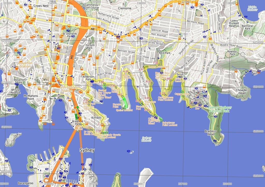
1 Harbour Bridge to Taronga Zoo 4 hrs 9.8 km One way Moderate track 389m On this walk, you will explore much of the foreshore linking Milsons Point Station to Taronga Zoo Ferry wharf. The walk is mostly along footpaths sometimes beside roads and other times through parkland. There are a few places to grab a drink or a bight to eat, and plenty of places to stop and enjoy the majestic views of Sydney Harbour. 3 Maps, text & images are copyright wildwalks.com Thanks to OSM, NASA and others for data used to generate some map layers. m Cremorne Reserve 44m
2 Tunnel vent lookout This informal lookout in Bradfield Park offers one of the best vantage points of Sydney city and a close-up Harbour Bridge. Located above air vents for the Sydney Harbour Tunnel, there is a large grassy clearing beside the car park (and a fairly busy road) and some fancy toilets down below (wheelchair accessible). Don't expect to be alone when there is a special event on the harbour! Dr Mary Booth Lookout Offering a lovely view over Sydney Harbour and city, this lookout and reserve are named for Dr Mary Booth OBE( ). Dr Booth was a physician committed to the welfare of women, children and veterans, and was instrumental in the preservation of this space as public parkland. More info. Admiralty House Admiralty House is the official NSW residence of Australia's Governor-General. Originally part a larger land lease which included Kirribilli House, the oldest part of the stone building was completed in 1846 by Colonial Collector of Customs, Lt. Colonel J.G.N. Gibbes. The building, named 'Wotonga', passed through a number of owners until 1885, when it was bought for the Admiral of the Royal Navy's Australian Squadron. Amongst some controversy, the estate was handed to the Commonwealth government in 1913, and apart from five years during the Great Depression, has since been used for its current purpose. The grounds are usually open to the public once each year, commonly in spring. More info. Kirribilli House Kirribilli House is the official NSW residence of the Prime Minister of Australia. It was purchased from the Admiralty House estate in 1854, and the Gothic style residence was completed the following year by Adolphus Frederic Feez. After several more owners, PM Hughes approved the compulsory acquisition of the property in 192, to prevent the planned subdivision of the land. At first used as additional accommodation for Admiralty House, Kirribilli House was later leased to tenants for six years, before being restored for use by the Prime Minister of the day and international guests of the Commonwealth. Kirribilli House is usually open to the pubic once each year, commonly in spring. More info. Before You walk Bushwalking is fun and a wonderful way to enjoy our natural places. Sometimes things go bad, with a bit of planning you can increase your chance of having an ejoyable and safer walk. Before setting off on your walk check 1) Weather Forecast (BOM Metropolitan District) 2) Fire Dangers (Greater Sydney Region, unknown) 3) Park Alerts () 4) Research the walk to check your party has the skills, fitness and equipment required 5) Agree to stay as a group and not leave anyone to walk solo Think before you TREK The 'Think before you TREK' program developed by NSW Police & NPWS promotes the benefits of planning ahead for your bushwalking trip by using an easy to remember acronym: T R E K Take adequate supplies of food, water, navigation and first aid equipment. Register your planned route and tell friends and family when you expect to return. Emergency beacon (PLB's) should be carried on walks with significant gaps in mobile coverage (check terrain profile). Keep to your planned route and follow the map and walking trails. Topo Maps The maps provided on wildwalks are helpful, but there are times where you may need maps covering a broader area. Maps that cover this walk include; 1:25 Map Series:9133N PARRAMATTA RIVER 1:1 Map Series:913 SYDNEY Grade This walk has been graded using the AS The overall grade of the walk is dertermined by the highest classification along the whole track. 3 Length Time Quality of track Grade 3/6 Moderate track 9.8 km One way 4 hrs Clear and well formed track or trail (2/6) Signs Clearly signposted (1/6) Experience Required Weather Infrastructure No experience required (1/6) Weather generally has little impact on safety (1/6) Limited facilities, not all cliffs are fenced (3/6)
3 Are you ready to have fun? Please ensure you and your group are well prepared and equipped for all possible hazards and delays. Check park closures, weather information and Fire Danger Rating before setting out. Optional side trips and alternate routes noted are not included in this walks overall grade, length or time estimate. Please allow extra time for resting and exploring areas of interest. The authors, staff and owners of wildwalks take care in preparing this information but will not accept responsibility for any inconvenience, loss or injury you may experience. Please take care, have fun - Happy Walking. Getting there You can get to Milsons Point Station (gps: , ) by car, train or bus. Car: Parking fees apply in the area. You can get back from Taronga Zoo Wharf (gps: , ) by car, ferry or bus. Car: There is free parking available. Find up to date and more information inlcuding; travel directions, weather, park closures and walker feedback at Milsons Point Station (4 m 1 mins) From the eastern (Broughton St) entrance to Milsons Point Station, this walk heads downhill whilst keeping the Harbour Bridge to your right. The footpath soon leads past a tunnel (on your right) then past the steps (leading up to the bridge), and soon crosses Fitzroty St (at the traffic lights, with the tunnel to your right). The walk continues down the hill towards the water, with the parkland under the bridge on your right. Near the water, the footpath leads to a great view over the harbour (just as the road bends left to wind steeply down the hill)..4 Tunnel vent lookout This informal lookout in Bradfield Park offers one of the best vantage points of Sydney city and a close-up Harbour Bridge. Located above air vents for the Sydney Harbour Tunnel, there is a large grassy clearing beside the car park (and a fairly busy road) and some fancy toilets down below (wheelchair accessible). Don't expect to be alone when there is a special event on the harbour!.4 Tunnel vent lookout (32 m 6 mins) Turn left: From the tunnel vent lookout, this walk heads away from the Harbour Bridge, heading downhill along Olympic Dr which soon bends right. At the bottom of the hill, this walk turns left and follows the foreshore footpath a short distance to come to the 'Jeffreys St Ferry Wharf'. Continue straight: From Jeffreys St ferry wharf, this walk follows the foreshore footpath whilst keeping the harbour to your right. The walk heads over a bridge then past a large strangler fig tree beside a sandstone wall. This foreshore walkway also passes several seats, steps, historic items and grand harbour views, and passes over a couple of bridges before turning left and heading up a long flight of steps. At the top of these steps, the walk comes to a large grassy reserve and the signposted 'Dr Mary Booth Lookout'..72 Dr Mary Booth Lookout Offering a lovely view over Sydney Harbour and city, this lookout and reserve are named for Dr Mary Booth OBE( ). Dr Booth was a physician committed to the welfare of women, children and veterans, and was instrumental in the preservation of this space as public parkland. More info..72 Dr Mary Booth Lookout (33 m ) Continue straight: From 'Dr Mary Booth Lookout', this walk heads away from the Harbour Bridge view and turns right to find the end of Waruda St. From here, the walk follows the footpath along the side of Waruda St which leads down to the intersection with Beulah St. Continue straight: From the intersection, this walk heads along Waruda St whilst keeping the water glimpses to your right. At the end of a Waruda St, the walk turns left and heads up the steps then follows the path to soon turn right onto Kirribilli Ave. The walk heads past a old white building to find the gate to 'Admiralty House'. 1.5 Admiralty House Admiralty House is the official NSW residence of Australia's Governor- General. Originally part a larger land lease which included Kirribilli House, the oldest part of the stone building was completed in 1846 by Colonial Collector of Customs, Lt. Colonel J.G.N. Gibbes. The building, named 'Wotonga', passed through a number of owners until 1885, when it was bought for the Admiral of the Royal Navy's Australian Squadron. Amongst some controversy, the estate was handed to the Commonwealth government in 1913, and apart from five years during the Great Depression, has since been used for its current purpose. The grounds are usually open to the public once each year, commonly in spring. More info. 1.5 Optional sidetrip to Lady Gowrie Lookout (1 m ) Continue straight: From Admiralty House, this walk follows Kirribilli Ave towards the water view (keeping Admiralty House to your right). Soon the walk comes to another set of gates, Kirribilli House. Continue straight: From Kirribilli House, this walk heads towards the end of Kirribilli Ave, towards the water view. Just beyond the end of Kirribilli Ave, this walk heads down a few steps to come to the good views and signposted 'Lady Gowrie Lookout'. At the end of this side trip, retrace your steps back to the main walk then Turn right. 1.5 Kirribilli House Kirribilli House is the official NSW residence of the Prime Minister of Australia. It was purchased from the Admiralty House estate in 1854, and the Gothic style residence was completed the following year by Adolphus Frederic Feez. After several more owners, PM Hughes approved the compulsory acquisition of the property in 192, to prevent the planned subdivision of the land. At first used as additional accommodation for Admiralty House, Kirribilli House was later leased to tenants for six years, before being restored for use by the Prime Minister of the day and international guests of the Commonwealth. Kirribilli House is usually open to the pubic once each year, commonly in spring. More info. 1.5 Lady Gowrie Lookout Lady Gowrie Lookout is located beside Kirribilli House, and overlooks the Sydney Harbour east of the CBD. Offering a picnic table and a number of bench seats, visitors can wander down the old steps to the water's edge. Ultimately 'The Rt Hon The Dowager Countess of Gowrie', Zara Hore- Ruthven ( ) lobbied for the welfare of children in Australia, and also raised money for war veterans and other causes. Her husband, Alexander Hore-Ruthven, was Governor of South Australia and later NSW, and also Australia's longest serving Governor-General( ). More info. 1.5 Admiralty House (16 m 3 mins) Turn left: From 'Admiralty House', this walk heads directly away from the gates to cross Kirribilli Ave and follow Carabella St. Soon Carabella St leads to a three-way intersection with Holbrook Ave (on your right) Int of Carabella St and Holbrook Ave (71 m 14 mins) Continue straight: From the intersection, this walk heads north along Carabella St, initially keeping Holbrook Ave on your right (and the phone box to your left). Carabella St soon bends left, then a short time later this walk turns right into Peel St, then left into Elamang Ave. The walk soon passes 'Loreto Kirribilli' (school), then at the end of the Elamang Ave, this walk crosses the road to turn down McDougall St. A short distance down McDougall St, this walk comes to the entrance of the Ensemble Theatre Ensemble Theatre The Ensemble Theatre has been producing professional live theatre for longer than any other company in Australia. With two venues, this Kirribilli auditorium is well-known for the high-quality performances and the scenic location. The site also offers Bayly's Restaurant for fine dining, and is next door to Careening Cove Marina and the Sydney Flying Squadron, both of which house restaurants. More info Ensemble Theatre (9 m ) Continue straight: From the entrance 'Ensemble Theatre', this walk heads downhill along the footpath beside McDougall St. The path leads past the 'Sydney Flying Squadron' and turns right onto a gravel driveway leading into Milson Park. The walk heads around the locked gate to the grassy foreshore of Milson Park. 2.2 Milson Park Milson Park is located on Careening Cove, and offers public toilets, open grassy areas and a children's playground (separated from the road and waterways by a fence). A community garden was opened here in November 29. Just adjacent to this park is the small Miss Gladys Carey Reserve, named for a 'wonderful old lady who led a useful life'. More info. 2.2 Milson Park (66 m 14 mins) Continue straight: From Milson Park, this walk heads along the grassy foreshore, keeping the water to your right, and soon crosses a small bridge, finding 'Kirribilli Marina' at the end of 'Bradley Ave'. Here the walk heads up the steps and continues up the hill past 'Miss Gladys Carey Reserve', soon coming to a 'T' intersection with High St. Here the walk turns left and follows High St and at the cross street, turns right to head uphill along Hipwood St. The walk follows Hipwood Street as it bends left then merges with Adderstone Ave, where this walk then turns right onto Clark Rd. A fairly short distance down Clark Rd (just past number one), the walk comes to an intersection with set of steps (on your right, that lead into Anderson Park). Turn right: From the intersection, this walk heads down the steps then across the small timber bridge into Anderson Park. Here the walk follows the footpath along the foreshore and soon finds a semi-circular seating area with several plaques, a water view and a drinking fountain. The walk continues along the foreshore of the park to the far side to find a set of stairs heading up from between the toilets and Neutral Bay Marina Anderson Park Named for John Anderson, local councillor , this is a popular sporting reserve. Offering facilities for cricket in summer and soccer in winter, this park also has a drinking fountain and an amenities block with toilets and showers. A number of plaques commemorate the historical significances of this place Anderson Park (33 m ) Continue straight: From Anderson Park, this walk heads up the steps from between the toilets and 'Neutral Bay Marina'. The steps and footpath soon bend right and lead up behind the marina to find the footpath beside Kurraba Rd. Here, the walk turns right and continues up the hill, soon crossing Ben Boyd Rd, then about 2m further along Kurraba Rd, this walk turns right and takes the steps down to Manns Ave. The walk follows Manns Ave then crosses Hayes St to find the intersection with Wycombe Rd next to 'Ta Ta Thai'.
4 3 Optional sidetrip to Neutral Bay (Hayes Street) Fe (1 m ) Continue straight: From the intersection, this walk heads downhill along Hayes Street, passing the shops to soon find the entrance to Neutral Bay (Hayes Street) Ferry Wharf, down the bottom on the left. At the end of this side trip, retrace your steps back to the main walk then Turn right. 3 Neutral Bay (Hayes Street) Ferry Wharf Neutral Bay (Hayes Street) Ferry Wharf makes the third stop on the Neutral Bay ferry service from Circular Quay. There is a bus stop and picnic table at this scenic wharf and, within a block, you'll find restaurants, take-away food and boutique shops. 3 Int of Wycombe Rd and Hayes St (3 m 5 mins) Turn left: From the intersection, this walk follows 'Wycombe Rd' away from Hayes St. Just as Wycome Road bends left, this walk heads straight (right-ish) into Wallaringa Ave. Wallaringa Ave bends a couple of times and soon finds the signposted 'Nutcote House' on your right. 3.3 Nutcote House Nutcote House was designed for May Gibbs, author and creator of the bush babies, Snugglepot and Cuddlepie. Gibbs is noted to be the first author 'to give Australian children a fantasy world of their own'. Nutcote is open to the public Wednesday through Sunday 11am-3pm, and entry fees are $8 adult, $3 child, with family and concession rates available. For more information, phone (2) More info. 3.3 Nutcote House (24 m 4 mins) Continue straight: From Nutcote House, this walk heads along Wallaringa Ave, keeping the distant water views to your right. Soon the road bends left, and becomes Spains Wharf Rd. At the top of Spains Wharf Rd, this walk turns right and follows Kurraba Rd for a while until just past the phone box, where the footpath leads down some steps to find an intersection at the top of Kurraba ferry steps Top of Kurraba ferry steps (8 m ) Continue straight: From the intersection, this walk heads up the steps, keeping the Kurraba Road up to your left. The footpath soon leads past the 'Kurraba Wharf Store' and a short distance later comes to a three-way intersection with Shellcove Rd Optional sidetrip to Spains Lookout (31 m 5 mins) Veer right: From the intersection, this walk heads south-east along footpath beside Kurraba Rd, past a few apartment blocks to find a path signposted as the way to 'Kurraba Point Reserve'(on the right, just past number 137). Continue straight: From the intersection, this walk heads uphill following the footpath beside Kurraba Rd. Soon the walk takes the left fork in the road and heads down past Hodgson Lookout and just beyond the intersection with Baden Rd, to a small park and 'Spains Lookout' At the end of this side trip, retrace your steps back to the main walk then Turn right Spains Lookout Spains Lookout is in Kurraba Point Reserve, and offers a glorious view of Sydney Harbour, including the distant bridge past Kirribilli. The lookout was named for Captain Stanley Spain in 1937, a well-known local councillor. More info Kurraba Point Kurraba Point Reserve, previously known as Thrupp's Point and Ballast Point, was at one time a sandstone quarry. More recently, it has been regenerated into a grassy parkland, with harbour views that are very popular during special events. There is also a children's playground and many shady trees, and people can often be spotted with a fishing line in the water Int of Kurraba and Shellcove Rds (78 m 16 mins) Veer left: From the intersection, this walk heads along Shellcove Rd, which soon bends left and passes the 'Shellcove Road Jetty' path. The walk continues along the road and turns right into Honda Rd, then continues past 'Honda' house - the 1858 home of architect Grundy. The walk turns right into Bogota Ave which soon bends left and immediately finds a small park, an archway and lookout Bogota Ave Lookout Near the Bogota Ave entrance to Cremorne Reserve, this informal, fenced lookout takes in a partial view over Sydney Harbour. There is a bench seat, and a sign nearby with information about the park. For a more interesting view, visitors can go a short way into the reserve and take the steps down onto the beach/mud flat. Cremorne Reserve is a very popular park, offering a scenic walking track around the edges of Cremorne Point. It houses a ferry wharf, gardens and a pool, as well as a playground, cafe, picnic area and a number of public bathrooms Bogota Ave Lookout (75 m 15 mins) Turn right: From the bend in Bogota Ave opposite number 9, this walk heads under the 'Cremorne Reservation' archway and follows the path past the information signs. The path soon leads down some steps then past a less defined side track to Shell Cove Beach (on your right). The walk continues along the concrete path and after?14m comes to a small clearing with some more information signs and water views. The path continues behind the houses and soon passes the 'Cammeraygal Water View' information sign opposite a sandstone cave (on your left), ignoring the side paths to the houses along the way. After a further?18m, the path leads to a three-way intersection in an open area marked with 'Path to Milson Rd' sign (pointing left). Continue straight: From the intersection, this walk follows the 'Maccallum Pool' sign along the path, keeping the water views to your right. Soon the path leads to a 'Y' intersection in front of an apartment building (the path on the right leads to Maccallum Pool) Optional sidetrip to Maccallum Pool (3 m 1 mins) Veer right: From the intersection, this walk heads downhill towards the water along the concrete path. The path soon passes a 'The Rock Pool that Grew' information sign then goes down the steps. The walk continues down this path and steps and soon comes to the northern entrance of 'Maccallum Pool'. At the end of this side trip, retrace your steps back to the main walk then Turn sharp right Maccallum Pool Maccallum Pool is a harbour-side swimming pool, thought to have been originally constructed by Olympic swimmer Frederick Lane. It was restored in the 192s by local residents, notably Hugh Maccallum. In 193, the council took control of the pool, and bestowed the current name. More info Top of Maccallum Pool path (28 m 5 mins) Continue straight: From the intersection, this walk heads along the main concrete path, keeping the houses to your left and the water views to your right. After â ˆ7m, the path passes a drinking fountain and passes another side path (on your right). The walk continues along the main concrete path for â ˆ2m through the parkland, past a 'Cremorne Reserve' sign and comes to a 'T' intersection with the footpath on Milson Rd Int of Milson Rd and foreshore walk (15 m 3 mins) Veer left: From the intersection, this walk crosses Milson St, turns right and heads along what looks like a driveway (and is a driveway for a short time), keeping the water and Milson Rd to your right. The driveway soon narrows into a footpath, which this walk follows between the houses and palm trees. Just after the last house, the path comes to an intersection (with Sophie's Lookout and plaque on your right at the top of the steps) before the toilet and play area Sophies Lookout This unofficial lookout takes in sweeping views across Sydney Harbour, over top of Cremorne Point Wharf and 'Sophie's Place' cafe. The lookout is dedicated to Sophie Vaillant, long-term proprietor of the cafe below Cremorne Point Ferry Wharf Cremorne Point Ferry Wharf marks the first stop on the Mosman Ferry Service. The wharf is home to Sophie's Place cafe, serving coffee, food and drinks. A public phone, public toilets and a children's playground can all be found within 1m of this wharf. More info Optional sidetrip to Robertsons Point Lookout (2 m 3 mins) Veer right: From the intersection, this walk heads along the footpath directly away from the house, heading towards the toilet block and playground. The path leads past this park area and heads into the bush, then passes a couple of information signs to find a concrete rock cairn, built for the 'Clan of Donnachaidh' in 1988 (each rock has its town of origin carved in it). The walk then continues along the path past a picnic table (with views and some shade) to find the lookout at Robertsons Point. (There is a track with steps and ladder that continues further down to the very tip of the point for the adventurous). At the end of this side trip, retrace your steps back to the main walk then Veer right Robertsons Point Lookout Robertsons Point, also known as Cremorne Point, is home to Cremorne Reserve. At the very tip, visitors can wander down some old steps to the lighthouse, and the more adventurous can continue down a rather precarious ladder to the water's edge. The spectacular harbour views can be enjoyed from a number of bench seats. A memorial plaque reminds visitors to take extra care and respect the inherent dangers of the rocky coast Sophies Lookout (37 m ) Turn left: From the intersection, this walk heads along the footpath, keeping the houses to your left (that is, use the footpath on the far side of the houses from the wharf and road). The footpath leads behind the houses, enjoying the water views (on your right) and after about â ˆ25m, the path leads past a 'The Illustrated Sydney News' information sign. Here the walk continues for a short time further to a clear three-way intersection and a drinking fountain Elephants Ear The Lex and Ruby Graham Garden at Cremorne Point is quite remarkable, worthy of a little extra time on your walk. A chance planting of a tropical 'Elephant's Ear' bulb in 1959, which happened to thrive, led to a lifetime work for Lex Graham and his future wife, Ruby. They worked steadily for decades, clearing weeds and rubbish, improving the soil and building up the gardens with donated plants and cuttings Elephants Ear (4 m 9 mins) Continue straight: From the intersection, this walk heads along the main foreshore track, keeping the house to your left. The path almost immediately passes the northern end of the signposted 'Elephant's Ear' garden and continues past some other exotic gardens behind the houses,
5 whilst keeping the water views to your right. After?2m, the path leads to an information signabout the constructed environment and then to a clearing with a sandstone rotunda. There is a four-way intersection just above the 'Sydney Amateur Sailing Club' (on your right). Continue straight: From the intersection, this walk follows the 'Old Cremorne Wharf' sign sign gently uphill along the path, keeping the water to your right. The path soon comes to another intersection where this walk tends right, following the path for about 12m (passing a few informal side tracks) to find some large sandstone boulders and the entrance to the 'Old Cremorne' Ferry Wharf Old Cremorne Ferry Wharf (32 m ) Turn left: From the Old Cremorne Ferry Wharf entrance, this walk follows the footpath away from the power lines keeping the water to your right. The path leads up the hill and after?18m, the path heads up a set of steps. The path continues to enjoy water views (to your right), passing behind a row of houses. Soon the path bends left to pass a 'Cremorne Point' sign and find a clear three-way intersection and a bench seat Bottom of Hodgson Ave steps (43 m 9 mins) Turn right: From the intersection, this walk follows the 'Bromley Ave' sign along the footpath (not actually a road) between the row of houses to find a four-way intersection at the last house, number five. Continue straight: From 5 Bromley Ave, this walk heads down the steps and follows the path to cross the timber bridge over the valley. The walk bends right and follows the path for?25m, enjoying the water views to your right. The path then passes a 'Harnett Park' sign (and ignores the upper track on your left), then heads down some steps and turns left. The walk heads past the 'Rowers Restaurant' to a car park and the Mosman Bay Marina. 7.1 Rowers Restaurant Located deep in Mosmans Bay, the Rowers Restaurant is part of Mosman Rowers Club (distinct from Mosman Rowing Club at the Spit), between Mosman Marina and Sea Scouts Hall. Open to the public, the club houses a bistro, restaurant and bar, which are open for lunch and dinner daily, as well as breakfast on Sundays. For more information, call More info. 7.1 Mosman Bay Marina (4 m ) Continue straight: From Mosman Bay Marina, this walk follows the waterside footpath, keeping the water to your right. The path soon bends right to round to the apex of Mosmans Bay opposite 'Reid Park' and a children's playground. Here the walk continues around the bay and after?11m, comes to a large rock commemorating 'H.M.S Sirius'. The walk then continues?9m to the bush shelter and the entrance to Mosman Bay Ferry Wharf. 7.5 Mosman Bay Ferry Wharf and Shops Mosman Bay ferry wharf, located on Avenue Rd, is nestled in the deep Mosmans Bay, opposite the marina. The wharf houses Wharfy's cafe. Open weekdays 7am-2pm and weekends 7am-4pm, for more information call (2) Across the road is Mosman Wharf Store, selling groceries and snacks, newspapers, bait and travel tickets. Open weekdays 7am-7pm, Sat 8am-6pm & Sun 8am-2pm, for more information, call (2) Mosman Bay Ferry Wharf (27 m 6 mins) Turn left: From Mosman Bay Ferry Wharf, this walk heads up the steps opposite the wharf, next to the 'Mosman Wharf Store'. This path continues up the hill and up some more steps, and then crosses a minor road and heads up a ramp. Here the walk turns right and follows Mosman St. Mosman St soon bends left (and becomes Trumfield Lane) which continues up the hill to a 'T' intersection with McLeod St. This walk crosses McLeod St to find a driveway (just a bit to the right) and turns left, following the steps and footpath up the hill. This footpath soon leads to an intersection with Musgrave Street Int of Musgrave and McLeod Sts (33 m 8 mins) Turn right: From the intersection, this walk heads downhill along 'Musgrave St' towards the distant water views. At the end of the street, the walk comes to a turning area, bus stop, shelter and the entrance to the 'South Mosman Wharf' South Mosman Wharf (9 m ) Continue straight: From the shelter at the entrance to South Mosman Wharf, this walk heads downhill to soon turn left and heads up the steps next to the 'Exploring Curlew Camp Artists' Walk' sign. Soon the walk turns right at the 'T' intersection partway up the stairs then continues up ignoring the private property side paths to find the end of a short road. Here the walk follows the road to the intersection with Raglan St and the 'Curraghbeena Point Lookout' in front of 'The Castle' Curraghbeena Point Lookout Curraghbeena Point separates Little Sirius Cove from Mosmans Bay (formerly Sirius Cove). This well-kept little park at the point offers some lovely views over Sydney Harbour, with two bench seats and a drinking fountain nestled amongst the buildings Curraghbeena Point (4 m 9 mins) Turn left: From 'Curraghbeena Point Lookout', this walk heads up the hill following Raglan Street soon passing 'Herron Park' (on your left) then just before the sandstone wall (on the right) this walk turn right into the sandstone driveway then follows the 'Public Path' sign up the steps. At the top the path passes beside a house and then follows a short section of Raglan St to turn right into Curraghbeena Rd (near the playground and park). Here the walk heads down Curraghbeena Rd passing a lookout (on your right) and continues down the road to the very end where there is an intersection with a walking track and steps. 8.6 End of Curraghbeena Rd (25 m 8 mins) Turn right: From the end of Curraghbeena Road, the walk follows the 'Curlew Camp Walk' sign down the stairs next to the sandstone wall towards the water. at the bottom of these steps the walk comes to a telegraph pole and great unfenced water view. Here the walk turns left and follows a footpath behind the houses then down a few timber stairs cases. Here the walk follows the track through the bush to soon head up a few of steps onto Curlew Camp Road where there is a sign pointing back to 'Walking track to Curraghbeena Road'. Turn right: From the intersection, this walk heads up the hill along the narrow concrete road, keeping the houses to your left. Soon the road leads to an intersection with Illawarra St and some stairs (on your right) Int. Illawarra St and Curlew Camp Rd (1 m ) Turn right: From the intersection, this walk heads down the series of steps and along the footpath beside the children's playground. The walk then continues across the grassy clearing to the middle of Sirius Cove Reserve Sirius Cove Reserve Sirius Cove Reserve is next to the sandy beach of Little Sirius Cove, Mosman. The reserve is open and grassy, with a few picnic tables, a fenced playground and drinking fountain at the western end, and a toilet block at the eastern end. The beach has no surf and faces south to Cremorne Point. Road access is via Sirius Cove Road Sirius Cove Reserve (48 m 11 mins) Veer right: From the intersection, this walk heads along the park foreshore with the water to your right, then heads up the hill bending right. The walk follows the footpath below some houses and past a small beach with a two-storey scout hall. Just after the last house, the path comes to a three-way intersection at the start of a large wall/fence. There is a 'Curlew Camp' sign pointing back to 'Sirius Cove'. Continue straight: From the intersection, this walk follows the sign pointing to 'Curlew Camp', following the footpath beside the tall barbed wire fence and wall. The track leads over a few sections of boardwalk, and soon comes to an intersection (with a track on the right marked with another 'Curlew Camp' sign, pointing '13 metres' Optional sidetrip to Camp Curlew (12 m ) Turn right: From the intersection, this walk heads down the hill following the 'Welcome to Curlew Camp' sign. The track quickly turns right, over a boardwalk, then turns left down more stairs. The walk then winds down the hill to the corner of a large rock, just above the water. Continue straight: From the intersection, this walk heads down towards the water and onto the wooden platform. At the end of this side trip, retrace your steps back to the main walk then Continue straight Camp Curlew Camp Curlew was created in 189 as an artists' retreat, as was popular at the time. Artists of the day would visit for long periods (although women were not permitted to stay overnight), enjoying the surrounds and painting some of Australia's most prized works. Arthur Streeton is a notable artist who stayed at the camp. The site was less than rustic, with tents to accommodate billiards and dining, and also a hired cook and youth to help with odd jobs. Camp Curlew was abandoned after the siting of Taronga Zoo in the area in Int. Borogegal Walking Trail and Curlew Camp Trk (34 m 9 mins) Turn left: From the intersection, this walk heads along the fenceline, with the water below on the right of the track. The walk heads along large sections of boardwalk with a tall barbed- wire fence above on the left. After approximately 3m, the track turns left above a small beach and then after the beach turns right. The walk continues along the hillside, with the tall fence on the left, then heads up boardwalked steps and passes a building on the left before crossing the cul-de-sac to Taronga Zoo wharf Taronga Zoo Taronga Zoo was founded in 1916, with the vision of imitating the Hamburg Zoo's bar-less exhibits. Since its opening, Taronga Zoo has directed more attention to research, education and conservation efforts to support the animals. Taronga Zoo is open everyday 9am- 5pm. Phone: or groups@zoo.nsw.gov.au. More info.
6
7 Summary navigation sheet for the Harbour Bridge to Taronga Zoo km From Up/Dwn Length Initial directions (Use full tracknotes and maps for more detail) Start Milsons Point Station , (GR Parramatta River, ) m 1 mins From the eastern (Broughton St) entrance to Milsons Point Station, this walk heads downhill whilst keeping the Harbour Bridge to your right..4 Tunnel vent lookout , (GR Parramatta River, ) m 6 mins Turn left: From the tunnel vent lookout, this walk heads away from the Harbour Bridge, heading downhill along Olympic Dr which soon bends right..72 Dr Mary Booth Lookout , (GR Parramatta River, 34953) m Continue straight: From 'Dr Mary Booth Lookout', this walk heads away from the Harbour Bridge view and turns right to find the end of Waruda St. 1.5 Admiralty House , (GR Parramatta River, ) -9 1 m Optional sidetrip to Lady Gowrie Lookout. Continue straight: From Admiralty House, this walk follows Kirribilli Ave towards the water view (keeping Admiralty House to your right). 1.5 Admiralty House , (GR Parramatta River, ) m 3 mins Turn left: From 'Admiralty House', this walk heads directly away from the gates to cross Kirribilli Ave and follow Carabella St Int of Carabella St and Holbrook Ave , (GR Parramatta River, ) m 14 mins Continue straight: From the intersection, this walk heads north along Carabella St, initially keeping Holbrook Ave on your right (and the phone box to your left) Ensemble Theatre , (GR Parramatta River, ) m Continue straight: From the entrance 'Ensemble Theatre', this walk heads downhill along the footpath beside McDougall St. 2.2 Milson Park , (GR Parramatta River, ) m 14 mins Continue straight: From Milson Park, this walk heads along the grassy foreshore, keeping the water to your right, and soon crosses a small bridge, finding 'Kirribilli Marina' at the end of 'Bradley Ave' Anderson Park , (GR Parramatta River, ) m Continue straight: From Anderson Park, this walk heads up the steps from between the toilets and 'Neutral Bay Marina'. 3. Int of Wycombe Rd and Hayes St , (GR Parramatta River, 35254) m Optional sidetrip to Neutral Bay (Hayes Street) Ferry Wharf. Continue straight: From the intersection, this walk heads downhill along Hayes Street, passing the shops to soon find the entrance to Neutral Bay (Hayes Street) Ferry Wharf, down the bottom on the left. 3. Int of Wycombe Rd and Hayes St , (GR Parramatta River, 35254) m 5 mins Turn left: From the intersection, this walk follows 'Wycombe Rd' away from Hayes St. 3.3 Nutcote House , (GR Parramatta River, 35554) m 4 mins Continue straight: From Nutcote House, this walk heads along Wallaringa Ave, keeping the distant water views to your right Top of Kurraba ferry steps , (GR Parramatta River, ) m Continue straight: From the intersection, this walk heads up the steps, keeping the Kurraba Road up to your left Int of Kurraba and Shellcove Rds , (GR Parramatta River, ) m 5 mins Optional sidetrip to Spains Lookout. Veer right: From the intersection, this walk heads south-east along footpath beside Kurraba Rd, past a few apartment blocks to find a path signposted as the way to 'Kurraba Point Reserve'(on the right, just past num Int of Kurraba and Shellcove Rds , (GR Parramatta River, ) m 16 mins Veer left: From the intersection, this walk heads along Shellcove Rd, which soon bends left and passes the 'Shellcove Road Jetty' path Bogota Ave Lookout , (GR Parramatta River, ) m 15 mins Turn right: From the bend in Bogota Ave opposite number 9, this walk heads under the 'Cremorne Reservation' archway and follows the path past the information signs Top of Maccallum Pool path , (GR Parramatta River, 36536) -7 3 m 1 mins Optional sidetrip to Maccallum Pool. Veer right: From the intersection, this walk heads downhill towards the water along the concrete path Top of Maccallum Pool path , (GR Parramatta River, 36536) m 5 mins Continue straight: From the intersection, this walk heads along the main concrete path, keeping the houses to your left and the water views to your right.
8 Powered by TCPDF ( Summary navigation sheet for the Harbour Bridge to Taronga Zoo km From Up/Dwn Length Initial directions (Use full tracknotes and maps for more detail) 5.43 Int of Milson Rd and foreshore walk , (GR Parramatta River, ) m 3 mins Veer left: From the intersection, this walk crosses Milson St, turns right and heads along what looks like a driveway (and is a driveway for a short time), keeping the water and Milson Rd to your right Sophies Lookout , (GR Parramatta River, ) -8 2 m 3 mins Optional sidetrip to Robertsons Point Lookout. Veer right: From the intersection, this walk heads along the footpath directly away from the house, heading towards the toilet block and playground Sophies Lookout , (GR Parramatta River, ) m Turn left: From the intersection, this walk heads along the footpath, keeping the houses to your left (that is, use the footpath on the far side of the houses from the wharf and road) Elephants Ear , (GR Parramatta River, ) m 9 mins Continue straight: From the intersection, this walk heads along the main foreshore track, keeping the house to your left Old Cremorne Ferry Wharf , (GR Parramatta River, ) m Turn left: From the Old Cremorne Ferry Wharf entrance, this walk follows the footpath away from the power lines keeping the water to your right Bottom of Hodgson Ave steps , (GR Parramatta River, ) m 9 mins Turn right: From the intersection, this walk follows the 'Bromley Ave' sign along the footpath (not actually a road) between the row of houses to find a four-way intersection at the last house, number five. 7.1 Mosman Bay Marina , (GR Parramatta River, ) m Continue straight: From Mosman Bay Marina, this walk follows the waterside footpath, keeping the water to your right. 7.5 Mosman Bay Ferry Wharf , (GR Parramatta River, ) m 6 mins Turn left: From Mosman Bay Ferry Wharf, this walk heads up the steps opposite the wharf, next to the 'Mosman Wharf Store' Int of Musgrave and McLeod Sts , (GR Parramatta River, ) m 8 mins Turn right: From the intersection, this walk heads downhill along 'Musgrave St' towards the distant water views South Mosman Wharf , (GR Parramatta River, ) 18 9 m Continue straight: From the shelter at the entrance to South Mosman Wharf, this walk heads downhill to soon turn left and heads up the steps next to the 'Exploring Curlew Camp Artists' Walk' sign Curraghbeena Point , (GR Parramatta River, ) m 9 mins Turn left: From 'Curraghbeena Point Lookout', this walk heads up the hill following Raglan Street soon passing 'Herron Park' (on your left) then just before the sandstone wall (on the right) this walk turn right int End of Curraghbeena Rd , (GR Parramatta River, ) m 8 mins Turn right: From the end of Curraghbeena Road, the walk follows the 'Curlew Camp Walk' sign down the stairs next to the sandstone wall towards the water Int. Illawarra St and Curlew Camp Rd , (GR Parramatta River, ) -8 1 m Turn right: From the intersection, this walk heads down the series of steps and along the footpath beside the children's playground Sirius Cove Reserve , (GR Parramatta River, ) m 11 mins Veer right: From the intersection, this walk heads along the park foreshore with the water to your right, then heads up the hill bending right Int. Borogegal Walking Trail and Curlew Camp Trk , (GR Parramatta River, 37538) m Optional sidetrip to Camp Curlew. Turn right: From the intersection, this walk heads down the hill following the 'Welcome to Curlew Camp' sign Int. Borogegal Walking Trail and Curlew Camp Trk , (GR Parramatta River, 37538) m 9 mins Turn left: From the intersection, this walk heads along the fenceline, with the water below on the right of the track.
Currie Rd to Davidson Park
 Currie Rd to Davidson Park 3 hrs 7.2 km One way Moderate track 28m Starting at Currie Rd in Forestville, this walk follows Middle Harbour to Davidson Park, under Roseville Bridge. There are two optional
Balmoral Beach to The Spit
 Balmoral Beach to The Spit 2 hrs 30 mins.3 km One way Hard track 85m This walks follows the coast from Balmoral to the Spit and across Spit Bridge. There are some alternate tracks to consider at high-tides,
Hunters Hill to Epping Road
 Hunters Hill to Epping Road 2 hrs 30 mins 5.5 km One way Moderate track 154m An enjoyable walk through lower sections of the Lane Cove National Park, this walk features plenty of mangroves next to the
The Foreshore Walk. 24m. 1m Lake Macquarie LGA. 1 hr 15 mins 2.9 km One way. Hard track 81m
 The Foreshore Walk 1 hr 15 mins 2.9 km One way Hard track 81m This walk traverses the coastline of the Green Point reserve. By following a variety of tracks and occasionally traveling inland through eucalyptus
Echo Point to Leura Forest via Three Sisters and Giant Stairs loop
 Echo Point to Leura Forest via Three Sisters and Giant Stairs loop 3 hrs 3.8 km Circuit Hard track 512m This walk starts from the popular Echo Point, in Katoomba, and winds down to the base of the Three
Taronga Wharf to Chowder Bay
 Taronga Wharf to Chowder Bay 2 hrs 4.4 km One way Moderate track 246m Starting at Taronga Wharf, this walk passes many icons of Sydney, including Taronga Zoo, HMAS Sydney Mast, Chowder Bay. The walk also
Rail to River Walk. 3 hrs. Hard track 7.5 km Circuit. 222m
 Rail to River Walk 3 hrs Hard track 7.5 km Circuit 4 222m This walk is a great one from Chatswood Station to the Lane Cove River National Park. The walk descends through the vegetated bushland which fills
Wentworth Falls Conservation Hut Loop
 Wentworth Falls Conservation Hut Loop 3 hrs Hard track 6.7 km Circuit 4 341m This scenic walk from Wentworth Falls Station, winds along the Nature Trail to Conservation Hut, then drops into the magnificent
Morgans Creek to Padstow
 Morgans Creek to Padstow 2 hrs 45 mins 8 km One way Moderate track 3 144m This pleasant walk starts from the Morgans Creek park, at Henry Lawsons Drive, and follows the Georges River past the Boomerang
Govetts Leap Loop. 1065m. 909m Blue Mountains National Park. 4 hrs 30 mins 8.7 km Circuit. Hard track 380m
 Govetts Leap Loop 4 hrs 30 mins 8.7 km Circuit Hard track 380m This walk, from Blackheath Train Station, is a fantastic way to see some of the iconic areas of the Blue Mountains in the Blackheath area.
Little Digger Track to Davidson Reserve and Lyrebird Circuit
 Little Digger Track to Davidson Reserve and Lyrebird Circuit 4 hrs 3 mins 11.5 km One way Hard track 4 47m Exploring both the eastern and western sides of Middle Harbour Creek, this walk follows the Little
Little Digger Track. 68m. 1 Hr 2.2 km One way. Moderate track 93m. Moores Creek Reserve
 Little Digger Track Hr 2.2 km One way Moderate track 93m This walk follows Moores Creek through several reserves in east Roseville and East Lindfield. The track is named after Australia's 7th Prime Minster,
Sid Pulsford Walk. 175m. 33m. 1 hr 45 mins 4.1 km One way. Hard track 118m. Gosford LGA
 Sid Pulsford Walk 1 hr 5 mins.1 km One way Hard track 118m Sid Pulsford Walk explores the ridge top of Kincumber Mountain, from Honeman's Rock to Green Point. The walk mostly follows wide management trails.
Spit Bridge to Middle Head Forts
 Spit Bridge to Middle Head Forts 2 hrs 30 mins 6.3 km One way Hard track 4 181m This scenic walk takes you from the Spit Bridge, along the coast to explore the Middle Head Forts. There are a few alternate
Popes Glen, Pulpit Rock, Govetts Leap and Braeside Walk
 Popes Glen, Pulpit Rock, Govetts Leap and Braeside Walk 8 hrs Hard track 13.6 km Circuit 4 1068m This large circuit walk, from Popes Glen to Pulpit Rock, Govetts leap and along the Braeside Track, passes
Katoomba Falls Circuit
 Katoomba Falls Circuit hr 5 mins.5 km Circuit Hard track 59m For those looking for a walk involving more than simple boardwalk, this trail winding through the temperate rain forest could be just the thing.
Carrington Park to Leura Forest and pass loop
 Carrington Park to Leura Forest and pass loop 3 hrs Hard track 4.8 km Circuit 4 674m This walk is a fantastic way to see Leura Forest. The walk descends from Carrington Park, visiting Leura Forest and
Wallarah Coastal Walk
 Wallarah Coastal Walk 3 hrs 8.3 km Return Hard track 247m This walk starts at Caves Beach and travels south along the coastline, until reaching the Pinney s Headland Lookout. There are many opportunities
The Basin Track and Mackerel Track
 The Basin Track and Mackerel Track 3 hrs 5.9 km Circuit Hard track 226m This walk is a great way to see some popular areas in Ku-ring-gai Chase National Park. The walk from West Head Rd travels to The
Waterfall to Heathcote
 Waterfall to Heathcote 5 hrs Hard track 10.8 km One way 4 467m This walk explores the heart of Heathcote National Park, and is easily accessed with a train station at either end. Although relatively close
Teralba to Charlestown Park track head
 Teralba to Charlestown Park track head 4 hrs 30 mins 13.3 km One way Moderate track 3 220m This section of the Great North Walk starts from the Teralba train station and winds down and around the edge
Woolwich Wharf to Boronia Park
 Woolwich Wharf to Boronia Park 2 hrs 5.8 km One way Moderate track 175m Going through the streets of Hunters Hill, this walk is on the first segment of the Great North Walk. The majority of the walk is
Campbell Drive to Snapper Point
 Campbell Drive to Snapper Point 1 hr 45 mins 4.2 km One way Experienced only 135m This walk follows the Coast Track to Frazer Beach, along the Geebung and (overgrown) Grass Tree Tracks. From the northern
Rail to River and Stringybark Creek Reserve Walk
 Rail to River and Stringybark Creek Reserve Walk 4 hrs Hard track 11.2 km Circuit 4 302m This walk begins in the busy city of Chatswood and soon enters the nearby bushland around the Lane Cove River. The
Scenic World to Echo Point
 Scenic World to Echo Point 1 hr 15 mins 2.1 km One way Moderate track 192m This is one of the most popular tourist walks in the Katoomba area. The walk follows the cliffs along a well maintained and signposted
Epping to Eastwood Station (via Lane Cove River)
") Epping to Eastwood Station (via Lane Cove River) hrs 45 mins 10.2 km One way Moderate track 189m Epping to Eastwood, via Lane Cove River, is the longer route through the bush between the stations. This
Epping to Eastwood Station (via Lane Cove River) hrs 45 mins 10.2 km One way Moderate track 189m Epping to Eastwood, via Lane Cove River, is the longer route through the bush between the stations. This
Green Point Circuit Walk
 Green Point Circuit Walk 3 hrs 7.7 km Circuit Hard track 269m This walk visits all of the popular locations in Green Point Reserve, as well as some of the lesser-visited areas inland. Taking in Sea Eagle
Hornsby Blue Gum Walk
 Hornsby Blue Gum Walk 3 hrs Hard track 6.7 km Circuit 4 374m This delightful loop is one of the prettiest and most popular walks in the Hornsby area. Going from an environment of ferns and clear bushland
De Burghs Bridge to Fullers Bridge
 De Burghs Bridge to Fullers Bridge 2 hrs 3 mins Hard track 6 km One way 2m 4 Following the Lane Cove River, this walk mostly follows a section of the Great North Walk and is well maintained and signposted.
Hermitage Foreshore Track
 Hermitage Foreshore Track 1 Hr 2.2 km One way Moderate track 123m The Hermitage Foreshore Walk is a wonderful way to explore Sydney Harbour from the perspective of South Head. This walk starts from Nielsen
Mackerel Beach, West Head Loop
 Mackerel Beach, West Head Loop 5 hrs 8.6 km Circuit Hard track 422m The Mackerel Beach, West Head Loop is a walk which explores a large part of the West Head. The journey starts and finishes with a ferry
Wattamolla to Big Marley Beach
 Wattamolla to Big Marley Beach 4 hrs 10.4 km Circuit Moderate track 4m This walk is an excellent loop which takes in both the coast and the heathy inland of Royal National Park. Nearly the whole walk has
Epping to Pennant Hills Station (via Lane Cove River)
") Epping to Pennant Hills Station (via Lane Cove River) 3 hrs 5 mins 8.4 km One way Hard track 249m This walk, from Epping to Pennant Hills Station, is a great way to see the upper Lane Cove River Valley.
Epping to Pennant Hills Station (via Lane Cove River) 3 hrs 5 mins 8.4 km One way Hard track 249m This walk, from Epping to Pennant Hills Station, is a great way to see the upper Lane Cove River Valley.
Heathcote to Engadine via Audley
 Heathcote to Engadine via Audley 6 hrs 3 mins 5 km One way Hard track 4 635m Covering a large section of central Royal National Park, this walk goes through the heath and scrub along a well managed and
Middle Harbour Creek Loop
 Middle Harbour Creek Loop 5 hrs 45 mins 15.1 km Circuit Experienced only 5 570m This walk explores the upper reaches of Middle Harbour Creek, starting and ending at the great parklands at Davidson Park,
Dead Horse Gap Loop track
 Dead Horse Gap Loop track 4 hrs 30 mins Hard track 9.8 km Circuit 144m 4 This walk starts with a ride up the Kosciuszko Express Chairlift. There is an opportunity to eat at Australia's highest restaurant,
Mackerel Beach and Resolute Loop
 Mackerel Beach and Resolute Loop 3 hrs 5.4 km Circuit Hard track 384m This walk is another great walk in Ku-ring-gai Chase National Park, accessed by ferry. From the Mackerel Beach wharf, this walk uses
Callicoma Loop. 174m. 98m. 2 hrs. Hard track 5.1 km Circuit. 153m
 Callicoma Loop 2 hrs Hard track 5.1 km Circuit 153m This great circuit walk passes through some really nice forest around the fringe of Cherrybrook. Highlights of the walk include some beautiful rock overhangs
De Burgs Bridge to Thornleigh station
 De Burgs Bridge to Thornleigh station 3 hrs 45 mins 9.7 km One way Hard track 4 363m This walk follows a section of the Great North Walk, starting from De Burghs bridge. The walk winds north west, through
Sphinx, Warrimoo and Bobbin Head tracks
 Sphinx, Warrimoo and Bobbin Head tracks 4 hrs 9.6 km Circuit Moderate track 499m This great walk starts at the Sphinx Memorial and loops around via Cowan Creek, exploring diverse environments as it changes
Roseville to Macquarie Park
 Roseville to Macquarie Park 3 hrs 3 mins 8.8 km One way Hard track 4 29m This walk starts at Roseville station and explores the streets and alleyways of Roseville before joining the main spine of the Great
Dubbo Gully and Ten Mile Hollow Circuit (via Clares Bridge)
") Dubbo Gully and Ten Mile Hollow Circuit (via Clares Bridge) 2 Days Hard track 24.3 km Circuit 4 1117m This two day (or ten hour) walk follows several historic roads, now closed to traffic. Starting with
Dubbo Gully and Ten Mile Hollow Circuit (via Clares Bridge) 2 Days Hard track 24.3 km Circuit 4 1117m This two day (or ten hour) walk follows several historic roads, now closed to traffic. Starting with
Patonga to Woy Woy. 5 hrs 45 mins 15.5 km One way. Hard track. 497m
 Patonga to Woy Woy 5 hrs 45 mins 15.5 km One way Hard track 4 497m This walk explores a variety of environments from the shore line and coastal cliffs near Patonga, to the dry, rocky and open ridge line.
Berowra to Mt Kuring-gai
 Berowra to Mt Kuring-gai 4 hrs 30 mins 9.4 km One way Hard track 4 551m From the ridges above Cowan Creek, this walk takes in some great lookouts (especially around Mt Kuringgai) as well as enjoying an
Under and Over Cliff Walk
 Under and Over Cliff Walk 4 hrs 9.4 km Circuit Moderate track 576m This walk from Wentworth Falls Station is a fantastic way to see a large majority of the Wentworth Falls cliffline. The track winds under
Bouddi Coastal Walk. 5 hrs. Hard track 8.1 km One way. 364m
 Bouddi Coastal Walk 5 hrs Hard track 8.1 km One way 4 364m This is one of the longer walks in the Bouddi National Park and it is rich in scenery. The walk follows the coastline with many side trips to
Spit Bridge to Manly (Manly Scenic Walkway)
") Spit Bridge to Manly (Manly Scenic Walkway) 3 hrs 45 mins 9.1 km One way Moderate track 349m The Spit to Manly walk is a classic bushwalk on Sydney's Northern Beaches. The walk follows a well-maintained
Spit Bridge to Manly (Manly Scenic Walkway) 3 hrs 45 mins 9.1 km One way Moderate track 349m The Spit to Manly walk is a classic bushwalk on Sydney's Northern Beaches. The walk follows a well-maintained
Gordon to Chatswood Station
 Gordon to Chatswood Station 4 hrs 30 mins 12.2 km One way Hard track 4 381m This walk is a great way to get into the bush without being far from civilisation. The walk wanders through untouched valleys
Upper Rumbalara circuit
 Upper Rumbalara circuit 1 hr 30 mins 3.3 km Circuit Hard track 176m A great circuit walk, covering most of the walking tracks and sights in the upper section of the Rumbalara Reserve. There is some really
Epping to Gordon Station
 Epping to Gordon Station 4 hrs 15 mins 11.7 km One way Hard track 4 365m This walk, from Epping Station to Gordon Station, passes below the homes which sit on the hills high above the Lane Cove River.
National Pass from Wentworth Falls to Conservation Hut
 National Pass from Wentworth Falls to Conservation Hut 3 hrs Hard track 3.6 km One way 739m Starting at Wentworth Falls picnic area, this scenic and historic walk explores many waterfalls, lookouts and
Federal Pass Walking Track
 Federal Pass Walking Track 5 hrs Hard track 8 km One way 4 989m This classic trail follows along the base of the cliffs from Leura to the Golden Stairs, passing many of the more popular sights of the Katoomba
Wentworth Falls Station Loop (Undercliff Walk)
") Wentworth Falls Station Loop (Undercliff Walk) 4 hrs 3 mins Hard track 8.9 km Circuit 658m 4 This walk passes some stunning waterfalls and views into the Jamison Valley, following the cliff edges around
Wentworth Falls Station Loop (Undercliff Walk) 4 hrs 3 mins Hard track 8.9 km Circuit 658m 4 This walk passes some stunning waterfalls and views into the Jamison Valley, following the cliff edges around
Blackheath Station to Junction Rock Loop (via Grand Canyon and Popes
 Blackheath Station to Junction Rock Loop (via Grand Canyon and Popes 8 hrs 30 mins 18.2 km Circuit Hard track 4 1254m This circuit starts in Blackheath and heads down into the Grand Canyon and Rodriguez
Lane Cove Tourist Park River Circuit
 Lane Cove Tourist Park River Circuit 5 hrs 12 km Circuit Hard track 383m This walk follows a large section of Lane Cove River. The walk follows the Riverside Walking track up the Lane Cove River to De
North Ryde Fairyland circuit
 North Ryde Fairyland circuit 2 hrs 30 mins Hard track 6.9 km Circuit 193m 4 Starting at North Ryde train station this walk explores a stretch of the Lane Cove River, visiting the historic Fairlylands Pleasure
Sphinx to Mt Kuring-gai
 Sphinx to Mt Kuring-gai 4 hrs 45 mins 1.7 km One way Hard track 673m This walk starts at the Sphinx War Memorial and follows some well maintained and popular walking tracks down to Cowan Creek. Enjoy the
Taronga Zoo to Spit Bridge
 Taronga Zoo to Spit Bridge 5 hrs Hard track 1.4 km One way 4 41m This is a scenic and culturally rich walk with views over Sydney Harbour and many interesting heritage buildings along the way. The start
MAP BOOKLET IMPORTANT CONTACTS SUNDAY 24 MARCH In an emergency please call 000 Medics. Event contacts
 SUNDAY 24 MARCH 2019 Help raise funds for the Cancer Centre for Children at The Children s Hospital at Westmead MAP BOOKLET IMPORTANT CONTACTS In an emergency please call 000 Medics (02) 8005 MEDIC or
Glenbrook and Euroka Circuit
 Glenbrook and Euroka Circuit 2 Days 16.6 km Circuit Experienced only 790m This two day circuit, returning to Glenbrook Station, is a scenic walk which passes many of the tourist attractions within the
Echo Point to Leura Forest Circuit
 Echo Point to Leura Forest Circuit 3 hrs 4.8 km Circuit Hard track 588m Forming a circuit around the cliffs and then the valley floor, this is a walk more then capable of convincing a walker of the beauty
Wentworth Falls Loop. 893m. 665m. 6 hrs 10.2 km Circuit. Hard track 1093m. Blue Mountains National Park
 Wentworth Falls Loop 6 hrs 1.2 km Circuit Hard track 193m This is a great walk, both in size and spectacular views. The walk makes its way from Wentworth Falls train station and drops off the plateau,
Manly to Seaforth Oval
 Manly to Seaforth Oval 5 hrs 45 mins 13.7 km One way Moderate track 3 624m This walk follows the Manly to Spit Scenic Walkway, then continues past The Spit Bridge to Seaforth Oval. The walk provides magnificent
Wentworth Falls Station Loop
 Wentworth Falls Station Loop 5 hrs 3 mins 9.5 km Circuit Hard track 4 13m The Wentworth Falls Station Loop takes in most of the upper tracks around Wentworth Falls. There are many scenic views near the
Scenic world to Three Sisters Loop via Furber Steps
 Scenic world to Three Sisters Loop via Furber Steps 5 hrs 5.8 km Circuit Hard track 722m This walk starts from the popular Scenic World, in Katoomba, and winds down the Furber steps into the Jamison Valley,
Thornleigh to Hornsby
 Thornleigh to Hornsby 4 hrs Hard track 10.2 km One way 4 526m Starting at Thornleigh station you walk through suburban streets for a short while before diving into the bush at the southern end of Berowra
Chatswood to Epping Station
 Chatswood to Epping Station 6 hrs Hard track 16.3 km One way 4 533m This walk, from Chatswood to Epping, is a long but enjoyable walk along the Lane Cove valley. The walk mostly follows the Lane Cove River
Bobbin Head Loop. 166m. 0m Ku-ring-gai Chase National Park. 5 hrs 12.9 km Circuit. Hard track 619m
 Bobbin Head Loop 5 hrs 12.9 km Circuit Hard track 619m This great circuit walk enjoys a variety of landscapes in Ku-ring-gai Chase National Park. The walk starts at the historic Sphinx war memorial and
Bouddi Ridge and Coastal Walk
 Bouddi Ridge and Coastal Walk 2 Days Hard track 27 km Circuit 4 126m This overnight walk takes in the majority of the magnificent Bouddi National Park. The walk starts from the pleasant Putty Beach camping
Charlestown Park trackhead to Newcastle station
 Charlestown Park trackhead to Newcastle station 5 hrs 30 mins 12.1 km One way Hard track 4 287m This section of the Great North Walk starts from the Charleston Park track head and winds through the streets
The Coast Track. 2 Days. Hard track 27.4 km One way. 1351m
 The Coast Track 2 Days Hard track 27.4 km One way 4 1351m Heading south, this walk covers the coastline of the Royal National Park and can truly only be described as amazing. With breathtaking coastal
Cape Banks Circuit. 50m. 2m Botany Bay National Park. 3 hrs 7.3 km Circuit. Hard track 190m
 Cape Banks Circuit 3 hrs 7.3 km Circuit Hard track 19m This Cape Banks Circuit has a lot to offer and is thoroughly recommended. The walking travels over beaches, through coastal forest and across exposed
Faulconbridge to Blaxland
 Faulconbridge to Blaxland 2 Days Experienced only 15.2 km One way 5 693m This two-day walk, or very solid one-day walk, takes you from station to station, through lush, scenic forest in the lower Blue
Rumbalara Explorer. 158m. 5m Rumbalara Reserve. 2 hrs 45 mins 6.1 km Circuit. Hard track 326m
 Rumbalara Explorer 2 hrs 5 mins 6.1 km Circuit Hard track 326m Pretty well the grand tour of the Rumbalara Reserve, this walk takes in much of the great scenery the reserve has to offer. The walk covers
Gosford to Lisarow. 202m
 Gosford to Lisarow 4 hrs 3 mins Hard track 11.3 km One way 4 479m This walk is a great way to explore the ridge-top bushland between Gosford and Lisarow. Passing through Rumbalara and Katandra Reserves,
Narrabeen Lagoon Trail (from Middle Creek)
") Narrabeen Lagoon Trail (from Middle Creek) 2 hrs 30 mins 8.6 km Circuit Very easy 1 105m The Narrabeen Lagoon Trail is a wonderful and accessible walk on the Northern Beaches of Sydney. The trail is used
Narrabeen Lagoon Trail (from Middle Creek) 2 hrs 30 mins 8.6 km Circuit Very easy 1 105m The Narrabeen Lagoon Trail is a wonderful and accessible walk on the Northern Beaches of Sydney. The trail is used
Light to Light Walk 2 days
 Light to Light Walk 2 days 2 Days Hard track 3.9 km One way 4 794m Over two days, this classic walk explores the coast from Boyd Tower to the Green Cape Lighthouse in the south. Hegartys Bay Camp is over
Sydney to Thornleigh via Lane Cove Tourist Park
 Sydney to Thornleigh via Lane Cove Tourist Park 2 Days 33 km One way Hard track 4 1114m This overnight walk starts from the Obelisk in Macquarie Park, Sydney, at the official start of the Great North Walk.
The Year Of Mercy Pilgrimage Sts Peter and Paul s Church, Bulimba To The Cathedral of St Stephen
 The Year Of Mercy Pilgrimage Sts Peter and Paul s Church, Bulimba To The Cathedral of St Stephen Dist Route Photos Photos 0.0km St Peter and Paul s Church, 235 Riding Rd & Cnr Main Ave, Balmoral. http://www.bulimbacatholic.com/
Six Foot Track. 1212m
 Six Foot Track 3 Days 44.8 km One way Hard track 4 2066m This classic walk takes you from Katoomba to Jenolan Caves via a historic horse route. The walk travels mainly along well-maintained service tracks
Directions for Day 1: Colwood To Metchosin
 Colwood-Metchosin Page 1 of 8 Directions for Day 1: Colwood To Metchosin Start: Royal Roads University, Birds of a Feather B&B, or at Esquimalt Lagoon Finish: Your accommodation in Metchosin Time: 4-5
A Walk from Our Lady of Victories Church, Bowen Hills to The Cathedral of Saint Stephen
 A Walk from Our Lady of Victories Church, Bowen Hills to The Cathedral of Saint Stephen 1 0.0km 30m 185m 270m From the Start to Breakfast Creek Rd is 8 minutes This pilgrimage walk should take the average
The Hundred Parishes
 The Hundred Parishes Walks from railway stations number 9 6.4 miles (10kms) from Bishop s Stortford to Stansted Mountfitchet Start: Bishop s Stortford station (Grid Reference TL492209) (ample parking and
EXECUTIVE SUMMARY Callan Park accommodates travel from a wide range of transport modes, including walking, cycling, bus and light rail.
 TRANSPORT AND ACCESS EXECUTIVE SUMMARY Callan Park accommodates travel from a wide range of transport modes, including walking, cycling, bus and light rail. Whilst there are some walking facilities within
Beautiful Walks from the Blue Ball Inn
 Walk No. 7 COAST AND VALLEY WALK Countisbury, Glenthorne, County Gate, Brendon, Rockford and Wilsham 10 MILES APPROX. Walking time 5 hours approx. (not including breaks)> OS Sheet 64/74 Lynton and Lynmouth.
MAPS & WALK NOTES. DAY 2: Greenwich Wharf to Woolwich Wharf
 MAPS & WALK NOTES DAY 2: Greenwich Wharf to Woolwich Wharf Total Distance: 15.5km Time: Approximately 5 hours 30 mins five Sections Walk Notes in Section Name Length Time 2:1 Greenwich Wharf to Northwood
NEWLANDS CORNER AND ST MARTHAS
 NEWLANDS CORNER AND ST MARTHAS 10k CIRCULAR ROUTE 2½-3HRS GU4 8SE From Newlands Corner on the North Downs just outside Guildford, you can enjoy one of the most beautiful panoramas of quintessential English
Walk 7: Watchet to washford
 Walk 7: Watchet to washford Length: Moderate - 7.5 miles / 12 km Good For: Theme: History Duration: 2-3 hours depending on speed of walking Notes: This is a moderate to difficult walk in places, with steps,
SELF GUIDED TOURING ROUTE
 SELF GUIDED TOURING ROUTE Things to see and places to go on the loop from Orbost to Marlo, Cape Conran, Cabbage Tree and back to Orbost (or onwards to Cann River) V6 April 2017 This guide should be read
Rhossili - Tears Point - Mewslade Bay - Talgarth's Well - Rhossili - ID: 148. Walk description:
 Walk description: A glorious walk combining thrilling cliffs with beautiful wild beaches and a bird's-eye view of the Gower peninsula from Rhossili Down. The adventurous can walk out to the Worm's Head
10 Miles Circular 5 hours
 VISIT RYEDALE PICKERING AND CAWTHORN CAMPS 10 Miles Circular 5 hours Moderate Terrain 120616 A 10 mile (16km) there and back walk from the market town of Pickering in Ryedale. The route heads north through
RILLINGTON TO MALTON by Tania Dickinson
 RILLINGTON TO MALTON by Tania Dickinson This walk takes you from the Vale of Pickering up on to the Wold scarp, before dropping down again through the pretty village of Settrington and joining the Centenary
Tideswell to Castleton
 Tideswell to Castleton 1 Walk summary Length: 14 km, 8.5 miles Maps: OS Explorer OL1 The Peak District - Dark Peak Area, OS Explorer OL24 The Peak District - White Peak Area, OS Landranger 110 Sheffield
LDWA SOUTH DOWNS MARATHON
 AHD ahead SDW South Downs Way BL/BR bear left/bear right TL/TR turn left/turn right SP signpost/fingerpost X cross LEG 1 - EAST DEAN to WP1 NORTON GR 470019. Open 1030 to 1300. 9.6 miles. 1.1 From village
LDWA SOUTH DOWNS MARATHON 13 th MAY 2018
 AHD ahead SDW South Downs Way BL/BR bear left/bear right TL/TR turn left/turn right X cross LEG 1 - EAST DEAN to WP1 NORTON GR 470019. Open 1030 to 1300. 9.7 miles. 1.1 From village hall TL and walk to
Access Statement for Loch of Strathbeg
 This access statement does not contain personal opinions as to our suitability for those with access needs, but aims to accurately describe the facilities and services that we offer all our guests/visitors.
The Mendip Way. Route Directions and Maps Wells to Frome
 The Mendip Way Route Directions and Maps Wells to Frome Website: www.mendiphillsaonb.org.uk Email: mendip@mendiphillsaonb.org.uk Facebook & Twitter: @MendipHillsAONB Phone: 01761462338 1 Wells to Shepton
Christchurch to Hengistbury Head
 Last checked 6 June 2018 Document last updated: 13 July 2018 This document and information herein are copyrighted to Saturday Walkers Club. If you are interested in printing or displaying any of this material,
BALCOMBE AND ARDINGLY RESERVOIR, WEST SUSSEX
 BALCOMBE AND ARDINGLY RESERVOIR, WEST SUSSEX 7 miles Circular 4 hours 080816 Challenging Terrain Hi, I'm Luke and this is my West Sussex Weekends walk It's a 7 mile loop from Balcombe rail station, taking
THE WELLDIGGERS ARMS, HESWORTH AND FITTLEWORTH TRAIL
 THE WELLDIGGERS ARMS, HESWORTH AND FITTLEWORTH TRAIL 5.5 miles Circular 3 hours 041017 Challenging Terrain A 300-year-old pub turned country-inn on the edge of the South Downs National Park, The Welldiggers