De Burgs Bridge to Thornleigh station
|
|
|
- Crystal Cook
- 5 years ago
- Views:
Transcription


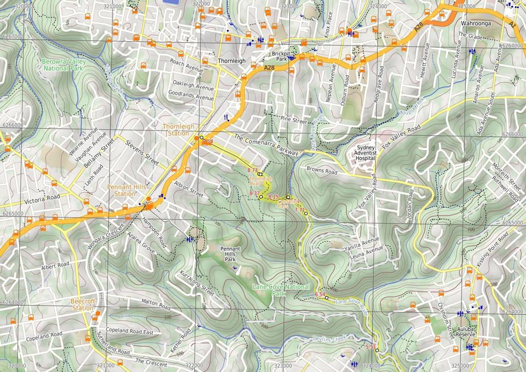
1 De Burgs Bridge to Thornleigh station 3 hrs 45 mins 9.7 km One way Hard track 4 363m This walk follows a section of the Great North Walk, starting from De Burghs bridge. The walk winds north west, through the Lane Cove Valley, passing through Browns Waterhole and continuing alongside Lane Cove river as it zigzags along the valley floor. The walk then climbs up to the Thornleigh playing field and along the streets to Thornleigh train station 170m 12m Lane Cove National Park Maps, text & images are copyright wildwalks.com Thanks to OSM, NASA and others for data used to generate some map layers.

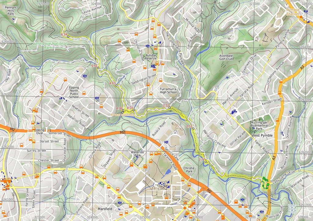
2 Browns Waterhole Before You walk Browns Waterhole is a wide, shallow section of the Lane Cove River, downstream of a concrete weir. There is a concrete shared cycle/footpath crossing over the top of the weir, linking Kissing Point Road, South Turramurra to Vimiera Rd, Macquarie Park. On the western side of the waterhole, there is a picnic table and small clearing with a view over this section of the river. Bushwalking is fun and a wonderful way to enjoy our natural places. Sometimes things go bad, with a bit of planning you can increase your chance of having an ejoyable and safer walk. Before setting off on your walk check Conscript Pass Conscript Pass is a small sandstone pass between the Lane Cove River and Thornleigh, on the Great North Walk. During the 1930s, some stone steps were built through a cleft in the rock as part of a public works program, in response to the depression. The pass has two main engravings. Firstly 'Conscript Pass' is followed with a downwards pointing arrow and a series of initials and numbers. On another wall (that you face when walking up) is engraved 'B Stevens' followed a surprisingly good caricature of the then Premier of NSW, Bertram Stevens. Stevens (later knighted) replaced Jack Lang in 1932 as Premier of NSW, when Lang was dismissed by the Governor (just two months Lang after opening the Sydney Harbour Bridge). Thornleigh Oval Thornleigh Oval is found at the intersection of Handley and Ferguson Avenues, Thornleigh. There is a large playing field, tap water, public toilets and some shelter in the awning of the club house. The oval has a car park, and a number io signs for the Great North walk and other local tracks. 1) Weather Forecast (BOM Metropolitan District) 2) Fire Dangers (Greater Sydney Region) 3) Park Alerts (Lane Cove National Park, Berowra Valley National Park) 4) Research the walk to check your party has the skills, fitness and equipment required 5) Agree to stay as a group and not leave anyone to walk solo Think before you TREK The 'Think before you TREK' program developed by NSW Police & NPWS promotes the benefits of planning ahead for your bushwalking trip by using an easy to remember acronym: adequate supplies of food, water, navigation and first T Take aid equipment. your planned route and tell friends and family when R Register you expect to return. beacon (PLB's) should be carried on walks with E Emergency significant gaps in mobile coverage (check terrain profile). to your planned route and follow the map and walking K Keep trails. Topo Maps The maps provided on wildwalks are helpful, but there are times where you may need maps covering a broader area. Maps that cover this walk include; 1: Map Series:91304S HORNSBY, 91303N PARRAMATTA RIVER 1: Map Series:9130 SYDNEY Grade This walk has been graded using the AS The overall grade of the walk is dertermined by the highest classification along the whole track. 4 Grade 4/6 Hard track Length 9.7 km One way Time 3 hrs 45 mins Quality of track Rough track, where fallen trees and other obstacles are likely (4/6) Signs Directional signs along the way (3/6) Experience Required Some bushwalking experience recommended (3/6) Weather Storms may impact on navigation and safety (3/6) Infrastructure Limited facilities, not all cliffs are fenced (3/6)
3 Are you ready to have fun? Please ensure you and your group are well prepared and equipped for all possible hazards and delays. Check park closures, weather information and Fire Danger Rating before setting out. Optional side trips and alternate routes noted are not included in this walks overall grade, length or time estimate. Please allow extra time for resting and exploring areas of interest. The authors, staff and owners of wildwalks take care in preparing this information but will not accept responsibility for any inconvenience, loss or injury you may experience. Please take care, have fun - Happy Walking. Getting there You can get to Int. Opposite the end of Lady Game Drive (gps: , ) by car or bus. Car: There is free parking available. You can get back from Thornleigh Train Station (gps: , ) by car, train or bus. Car: There is free parking available. Find up to date and more information inlcuding; travel directions, weather, park closures and walker feedback at 0 Int. Opposite the end of Lady Game Drive (1.8 km 37 mins) From the intersection, this walk passes over the timber railing and turns left down the hill. The track winds down the hill for approximately 200m to the signposted intersection. Turn right: From the intersection, this walk follows the 'The Great North Walk' sign north, gently downhill along the management trail. After about 80m, this trail crosses a concrete bridge over Rudder Creek (beside a concrete sewerage pipe). From here, the trail leads uphill for just shy of 200m to come to an intersection with the GNW track (on your left), where a 'Lane Cove Weir' sign points back down along the trail. Turn left: From the intersection, this walk follows the 'Thornleigh Oval' sign west, gently down the track, away from the management trail. The track almost immediately passes the large metal pipe (crossing the Lane Cove River) then winds down the rocky track for about 200m, through open eucalypt forest with some limited views left over the valley, to come to a weedy section of track marked with a concrete sewerage access point. Here the track mostly flattens out and leads along the side of the hill for about 400m to head down a few steps and cross Quarry Creek. The walk then heads up some steps and follows the track for another 30m to come to a Tintersection with the Gloucester Ave fire trail, marked with a GNW and NPWS arrow post. Turn left: From the intersection, the walk follows the GNW arrow post gently uphill along the management trail, away from the gate whilst keeping the power line poles on your left. After about 30m (just past the second power pole), this trail leads to an intersection with a track (on the left), marked with another set of NPWS & GNW arrow posts (just under the high tension power lines). Turn left: From the intersection, this walk follows the GNW arrow post south, downhill along the track and under the high tension power lines. The track winds gently downhill for almost 150m until, just after passing close to the the high tension power line tower, this walk comes to a locked green shed opposite a fenced-off pipe bridge (down in the valley to your left). Continue straight: From the green shed, this walk follows the track along the side of the hill, keeping the valley to your left (running parallel with the high tension power lines, up to your right). After about 150m, this walk comes to an intersection with a faint track on your right (that leads a short distance to a management trail), marked with a GNW arrow post. Continue straight: From the intersection, this walk follows the GNW arrow post along the mostly flat track, through the dense forest, and almost immediately passes a concrete sewerage access point. After about 70m, this walk heads down a few timbers steps to cross a small gully, where the track continues for another 100m (passing close to a few houses), then crosses two flat timber bridges over Congham Creek. Here the walk veers left up onto the rock platform and follows the track gently uphill for another 80m to come to a three-way intersection, marked with a GNW arrow post (and a sign pointing left to 'Marsfield') Int of GNW and Christie Park track (760 m 18 mins) Veer right: From the intersection, the walk follows the GNW arrow post north, uphill for about 30m to come to a faint intersection with a track (on your right) marked with a GNW arrow post. Veer left: From the intersection, this walk follows the GNW arrow post gently uphill along the side of the hill (keeping the valley to your left) for about 100m to come to a small clearing and three way intersection, marked with yet another GNW arrow post and a pile of rocks (on your left). Turn left : From the intersection, this walk follows the GNW arrow post up the short rocky hill and away from the high tension power lines. The track (rocky early on) leads along the side of the hill among some grass trees for about 300m before passing under the power lines again. Here the track continues for another 300m along the side of the valley to come to a clear intersection with intersection with a wide management trail Int of the GNW and the West Pymble service trail l (700 m 17 mins) Continue straight: From the intersection, this walk follows the GNW arrow post downhill along the management trail. The trail leads down for about 70m to cross a small gully then runs closely beside the Lane Cove River (on your left) for another 120m to come to an intersection marked with a GNW arrow post and a 'Lane Cove Valley' aluminum sign and map. Turn left : From the intersection, this walk follows the GNW arrow post, directly away from the face of the 'Lane Cove Valley' aluminum sign and map, down the track and timber steps to a sandy beach on the Lane Cove River. Here the walk turns right to cross the weir and bridge over Avondale Creek, (this may become impassable after heavy or prolonged rain) then climb gently uphill for about 120m to come to a faint intersection with a faint track (on your left - this faint track leads down to another old weir). Continue straight: From the intersection, this walk heads gently uphill following the main track, whilst keeping the valley to your left for about 30m to come to a clear Y-intersection marked with a GNW arrow post. Veer left: From the intersection, this walk follows the GNW arrow post along the track, keeping the Lane Cove River a short distance to your left. After about 80m, the track steps up to and crosses a short section to timber boardwalk/bridge. Here the walk climbs up the rocky hill following a series of concrete access points and timber steps for about 230m to come to a Tintersection with a management trail, marked with a GNW arrow post Int of the GNW and the Turramurra High School serv (870 m 18 mins) Veer left: From the intersection, this walk follows the GNW arrow post gently downhill along the management trail for about 40m to come to an intersection with a short trail (on the right, which leads to the gate at the end of Koombalah Ave). Continue straight: From the intersection just below the Koombalah Ave gate, this walk follows the management trail gently downhill, whilst keeping the valley to your left. The trail initially leads over a rock platform, then about 50m later, leads down a steep hill. The trail then heads gently down for about 400m before a short steep hill leads down to a metal high tension power line tower. Here the trail bends right and leads down and along the side of the hill for another 200m to pass another high tension power line tower and head behind a few houses. Just behind the second house, this walk comes to ephemeral creek on a rock platform. Continue straight: From here, this walk crosses the ephemeral creek (keeping the houses up to your right) and continues along the trail for about 30m to come to a T-intersection with a wide, shared, concrete path, marked with several signposts. 4.1 Int of GNW and Kissing Point Road trail (260 m 5 mins) Turn left: From the intersection, this walk follows the GNW arrow post downhill along the wide, shared, concrete path. After about 50m, this path leads under some high tension power lines then bends right. About 50m after passing under the power lines, this path leads to an intersection with a track (on your left, that leads to an informal unfenced lookout), just before a GNW arrow post. Continue straight: From the intersection, the walk heads fairly steeply downhill along the concrete path. The path passes a few signs over about 100m, then comes to an intersection with a track (on your left), marked with a timber barricade and a GNW arrow post. Veer right: From the intersection, this follows the concrete path downhill for just shy of 50m to come to a intersection with a dirt management trail. This intersection is beside the Lane Cove River crossing (on your left) and is marked with a 'The Great North Walk' sign here Browns Waterhole Browns Waterhole is a wide, shallow section of the Lane Cove River, downstream of a concrete weir. There is a concrete shared cycle/footpath crossing over the top of the weir, linking Kissing Point Road, South Turramurra to Vimiera Rd, Macquarie Park. On the western side of the waterhole, there is a picnic table and small clearing with a view over this section of the river Browns Waterhole int (570 m 12 mins) Veer right: From the intersection, this walk follows the 'The Great North Walk' sign along the dirt management trail, keeping the Lane Cove River to your left. After about 80m, the trail leads under some high tension power lines, where there is a mostly clear view over the river (to your left). The trail then gently leads down through the valley for about 400m to come to an intersection with Cove St trail, marked with a GNW arrow post. Veer left: From the intersection, this walk follows the GNW arrow post downhill along the management trail for about 30m to cross a small culverted creek. The walk then follows the trail up the short hill to come to an intersection with the signposted 'STEP track' (on your right) Int of GNW and the STEP track (east) (580 m 10 mins) Continue straight: From the intersection, this walk follows the GNW arrow post and STEP Track markers along the management trail, whilst keeping the river to your left. The trail undulates through the valley (weedy in places) and tall forest for just shy of 600m, to come to a clear intersection at the bottom of a sealed management trail (on your right). This intersection is marked with another 'STEP Track' map/sign and a 'The Great North Walk' sign Int of GNW and the STEP track (west) (1 km 18 mins) Veer left: From the intersection, the walk follows the 'The Great North Walk' sign gently downhill along the management trail, directly away from the face of the 'STEP Track' map/sign. Keeping the river to your left, the trail leads downhill for about 80m to come to a Y-intersection, where there is a 'Lane Cove Valley' map/sign and a 'Lane Cove River Park' sign pointing back along the trail. Veer right: From the intersection, this walk follows the 'Thornleigh Station' sign past the 'Lane Cove Valley' map, initially keeping the other trail and river to your left. The trail follows the valley floor, keeping the river just to your left, for a bit over 500m, to then cross the Lane Cove River at a rocky ford. This crossing may become impassable after heavy or prolonged rain. On the other side of the river, this walk continues along the trail for about 400m (with the river now close by on your right) to come to an intersection with a faint track (on your left, that leads up towards Pennant Hills Park).
4 6.54 Int of GNW and the Pennant Hills Park track (1.2 km 21 mins) Continue straight: From the intersection, the walk follows the management trail, keeping the river just to your right. After about 60m, the trail bends right and crosses the Lane Cove River at a rocky ford, then continues along the valley floor among the fern trees (and concrete pipe access points) for about 900m to cross the Lane Cove River again at another rocky ford. (These crossings may become impassable after heavy or prolonged rain). The trail then continues along the valley floor (with the river now on your left) for just over 150m to come to an intersection at the bottom of the sealed Morona Ave trail (on your right), marked with a 'Lane Cove Valley' map/sign and a GNW arrow post Int of the GNW and the Morona Ave trail (330 m 8 mins) Veer left: From the intersection, this walk follows the GNW arrow post along the valley floor, away from the two trails, keeping the river just to your left. The track soon narrows, leading past a water depth indicator, and becomes rocky for about 150m before coming to a faint intersection, where GNW arrow post points left. Here, the walk turns left and crosses the Lane Cove River using the concrete stepping stones (this crossing may become impassable after heavy or prolonged rain) to follow the 'Thornleigh Station' sign up the timber steps for about 40m and find a GNW registration box (damaged at time of writing). The track bends sharply right and zigzags up the rocky hill for another 30m, before bending sharply left to find the 'Conscript Pass' and 'B Stevens' engravings (at the third metal hand rail) Conscript Pass Conscript Pass is a small sandstone pass between the Lane Cove River and Thornleigh, on the Great North Walk. During the 1930s, some stone steps were built through a cleft in the rock as part of a public works program, in response to the depression. The pass has two main engravings. Firstly 'Conscript Pass' is followed with a downwards pointing arrow and a series of initials and numbers. On another wall (that you face when walking up) is engraved 'B Stevens' followed a surprisingly good caricature of the then Premier of NSW, Bertram Stevens. Stevens (later knighted) replaced Jack Lang in 1932 as Premier of NSW, when Lang was dismissed by the Governor (just two months Lang after opening the Sydney Harbour Bridge) Conscript Pass (100 m 3 mins) Continue straight: From 'Conscript Pass', this walk heads up the stone steps through the cleft in the rock to follow the track and more stone steps uphill for about 100m, coming to a T-intersection with Lorna Pass track, marked with a GNW arrow post Int of the GNW and Lorna Pass tracks (230 m 7 mins) Veer left: From the intersection, the walk follows the 'Thornleigh' sign uphill along the rocky track, keeping the valley to your left. The track leads up a series of timber steps for about 230m, becoming steeper as they go, to come to a clear T-intersection signposted with a large 'The Great North Walk' sign, and a stone 'Lorna Pass' arrow pointing back down the track Int of GNW and BP scout camp tracks (350 m 7 mins) Veer right: From the intersection, this walk follows the GNW arrow post and 'Thornleigh Station' sign uphill along the wide rocky track. After just over 150m, the track bends left (ignoring a faint track on your right) and heads uphill for another 40m to come to the back (south-east corner) of Thornleigh Oval, marked with a 'Lane Cove National Park' signpost. Turn right: From the intersection, this walk follows the GNW arrow post along the fence line around the oval, keeping the oval to your left. After about 100m, this walk passes in front of the clubhouse (there are toilets and a water tap on your right) to pass a 'Great North Walk' sign and come to the corner of 'Handley' and 'Ferguson' Avenues in front of the 'Thornleigh Oval' sign Thornleigh Oval Thornleigh Oval is found at the intersection of Handley and Ferguson Avenues, Thornleigh. There is a large playing field, tap water, public toilets and some shelter in the awning of the club house. The oval has a car park, and a number io signs for the Great North walk and other local tracks Int of Handley and Ferguson Avenues (810 m 14 mins) Continue straight: From the intersection, this walk follows the 'Thornleigh Station' sign across the road to follow the footpath beside 'Handley Ave'. After about 130m, the walk crosses Clifford Ave then after about 250m, crosses 'Orchard St' to follow 'Station St' almost directly ahead. About 190m along 'Station St', this walk continues straight across 'Wood St' (you can get to Parkway Plaza if you turn right here) and continues for just over 200m to find a footbridge beside Pennant Hills Rd. Here the walk heads up the ramp and crosses over the busy road then down the ramp (or steps) to find the intersection with Railway Parade Int of Railway Parade and Pennant Hills Road overp (110 m 2 mins) Veer left: From the base of the steps, this walk follows the GNW arrow across 'Railway Pde', heading towards the train line. At the fence, this walk veers left and leads along the pedestrian alley for about 60m before turning right and climbing up the railway bridge steps, coming to the 'Thornleigh' Train Station.
5
6
7 Summary navigation sheet for the De Burgs Bridge to Thornleigh station km Up/Dwn Length Initial directions (Use full tracknotes and maps for more detail) Start Int. Opposite the end of Lady Game Drive , (GR Parramatta River, ) 1.77 Int of GNW and Christie Park track , (GR Parramatta River, ) 2.53 Int of the GNW and the West Pymble service trail link track , (GR Parramatta River, ) km 37 mins 760 m 18 mins 700 m 17 mins From the intersection, this walk passes over the timber railing and turns left down the hill Int of the GNW and the Turramurra High School service trail , (GR Parramatta River, ) m 18 mins Veer left: From the intersection, this walk follows the GNW arrow post gently downhill along the management trail for about 40m to come to an intersection with a short trail (on the right, which leads to the gate at Int of GNW and Kissing Point Road trail , (GR Parramatta River, ) Browns Waterhole int , (GR Parramatta River, ) Int of GNW and the STEP track (east) , (GR Parramatta River, ) Int of GNW and the STEP track (west) , (GR Parramatta River, ) Int of GNW and the Pennant Hills Park track , (GR Hornsby, ) Int of the GNW and the Morona Ave trail , (GR Hornsby, ) Conscript Pass , (GR Hornsby, ) Int of the GNW and Lorna Pass tracks , (GR Hornsby, ) Int of GNW and BP scout camp tracks , (GR Hornsby, ) Int of Handley and Ferguson Avenues , (GR Hornsby, ) Int of Railway Parade and Pennant Hills Road overpass steps , (GR Hornsby, ) m 5 mins 570 m 12 mins 580 m 10 mins 1 km 18 mins 1.2 km 21 mins 330 m 8 mins 100 m 3 mins 230 m 7 mins 350 m 7 mins 810 m 14 mins 110 m 2 mins Turn left: From the intersection, this walk follows the GNW arrow post downhill along the wide, shared, concrete path. Veer right: From the intersection, this walk follows the 'The Great North Walk' sign along the dirt management trail, keeping the Lane Cove River to your left. Continue straight: From the intersection, this walk follows the GNW arrow post and STEP Track markers along the management trail, whilst keeping the river to your left. Veer left: From the intersection, the walk follows the 'The Great North Walk' sign gently downhill along the management trail, directly away from the face of the 'STEP Track' map/sign. Continue straight: From the intersection, the walk follows the management trail, keeping the river just to your right. Veer left: From the intersection, this walk follows the GNW arrow post along the valley floor, away from the two trails, keeping the river just to your left. Continue straight: From 'Conscript Pass', this walk heads up the stone steps through the cleft in the rock to follow the track and more stone steps uphill for about 100m, coming to a T-intersection with Lorna Pass t... Veer left: From the intersection, the walk follows the 'Thornleigh' sign uphill along the rocky track, keeping the valley to your left. Veer right: From the intersection, this walk follows the GNW arrow post and 'Thornleigh Station' sign uphill along the wide rocky track. Continue straight: From the intersection, this walk follows the 'Thornleigh Station' sign across the road to follow the footpath beside 'Handley Ave'. Veer left: From the base of the steps, this walk follows the GNW arrow across 'Railway Pde', heading towards the train line Powered by TCPDF ( From Veer right: From the intersection, the walk follows the GNW arrow post north, uphill for about 30m to come to a faint intersection with a track (on your right) marked with a GNW arrow post. Continue straight: From the intersection, this walk follows the GNW arrow post downhill along the management trail.
Epping to Pennant Hills Station (via Lane Cove River)
") Epping to Pennant Hills Station (via Lane Cove River) 3 hrs 5 mins 8.4 km One way Hard track 249m This walk, from Epping to Pennant Hills Station, is a great way to see the upper Lane Cove River Valley.
Epping to Pennant Hills Station (via Lane Cove River) 3 hrs 5 mins 8.4 km One way Hard track 249m This walk, from Epping to Pennant Hills Station, is a great way to see the upper Lane Cove River Valley.
Epping to Gordon Station
 Epping to Gordon Station 4 hrs 15 mins 11.7 km One way Hard track 4 365m This walk, from Epping Station to Gordon Station, passes below the homes which sit on the hills high above the Lane Cove River.
Epping to Eastwood Station (via Lane Cove River)
") Epping to Eastwood Station (via Lane Cove River) hrs 45 mins 10.2 km One way Moderate track 189m Epping to Eastwood, via Lane Cove River, is the longer route through the bush between the stations. This
Epping to Eastwood Station (via Lane Cove River) hrs 45 mins 10.2 km One way Moderate track 189m Epping to Eastwood, via Lane Cove River, is the longer route through the bush between the stations. This
Hunters Hill to Epping Road
 Hunters Hill to Epping Road 2 hrs 30 mins 5.5 km One way Moderate track 154m An enjoyable walk through lower sections of the Lane Cove National Park, this walk features plenty of mangroves next to the
Hornsby Blue Gum Walk
 Hornsby Blue Gum Walk 3 hrs Hard track 6.7 km Circuit 4 374m This delightful loop is one of the prettiest and most popular walks in the Hornsby area. Going from an environment of ferns and clear bushland
Waterfall to Heathcote
 Waterfall to Heathcote 5 hrs Hard track 10.8 km One way 4 467m This walk explores the heart of Heathcote National Park, and is easily accessed with a train station at either end. Although relatively close
Currie Rd to Davidson Park
 Currie Rd to Davidson Park 3 hrs 7.2 km One way Moderate track 28m Starting at Currie Rd in Forestville, this walk follows Middle Harbour to Davidson Park, under Roseville Bridge. There are two optional
Morgans Creek to Padstow
 Morgans Creek to Padstow 2 hrs 45 mins 8 km One way Moderate track 3 144m This pleasant walk starts from the Morgans Creek park, at Henry Lawsons Drive, and follows the Georges River past the Boomerang
Teralba to Charlestown Park track head
 Teralba to Charlestown Park track head 4 hrs 30 mins 13.3 km One way Moderate track 3 220m This section of the Great North Walk starts from the Teralba train station and winds down and around the edge
Sid Pulsford Walk. 175m. 33m. 1 hr 45 mins 4.1 km One way. Hard track 118m. Gosford LGA
 Sid Pulsford Walk 1 hr 5 mins.1 km One way Hard track 118m Sid Pulsford Walk explores the ridge top of Kincumber Mountain, from Honeman's Rock to Green Point. The walk mostly follows wide management trails.
Govetts Leap Loop. 1065m. 909m Blue Mountains National Park. 4 hrs 30 mins 8.7 km Circuit. Hard track 380m
 Govetts Leap Loop 4 hrs 30 mins 8.7 km Circuit Hard track 380m This walk, from Blackheath Train Station, is a fantastic way to see some of the iconic areas of the Blue Mountains in the Blackheath area.
Popes Glen, Pulpit Rock, Govetts Leap and Braeside Walk
 Popes Glen, Pulpit Rock, Govetts Leap and Braeside Walk 8 hrs Hard track 13.6 km Circuit 4 1068m This large circuit walk, from Popes Glen to Pulpit Rock, Govetts leap and along the Braeside Track, passes
Echo Point to Leura Forest via Three Sisters and Giant Stairs loop
 Echo Point to Leura Forest via Three Sisters and Giant Stairs loop 3 hrs 3.8 km Circuit Hard track 512m This walk starts from the popular Echo Point, in Katoomba, and winds down to the base of the Three
Wentworth Falls Conservation Hut Loop
 Wentworth Falls Conservation Hut Loop 3 hrs Hard track 6.7 km Circuit 4 341m This scenic walk from Wentworth Falls Station, winds along the Nature Trail to Conservation Hut, then drops into the magnificent
Berowra to Mt Kuring-gai
 Berowra to Mt Kuring-gai 4 hrs 30 mins 9.4 km One way Hard track 4 551m From the ridges above Cowan Creek, this walk takes in some great lookouts (especially around Mt Kuringgai) as well as enjoying an
Rail to River Walk. 3 hrs. Hard track 7.5 km Circuit. 222m
 Rail to River Walk 3 hrs Hard track 7.5 km Circuit 4 222m This walk is a great one from Chatswood Station to the Lane Cove River National Park. The walk descends through the vegetated bushland which fills
De Burghs Bridge to Fullers Bridge
 De Burghs Bridge to Fullers Bridge 2 hrs 3 mins Hard track 6 km One way 2m 4 Following the Lane Cove River, this walk mostly follows a section of the Great North Walk and is well maintained and signposted.
Little Digger Track. 68m. 1 Hr 2.2 km One way. Moderate track 93m. Moores Creek Reserve
 Little Digger Track Hr 2.2 km One way Moderate track 93m This walk follows Moores Creek through several reserves in east Roseville and East Lindfield. The track is named after Australia's 7th Prime Minster,
Sphinx, Warrimoo and Bobbin Head tracks
 Sphinx, Warrimoo and Bobbin Head tracks 4 hrs 9.6 km Circuit Moderate track 499m This great walk starts at the Sphinx Memorial and loops around via Cowan Creek, exploring diverse environments as it changes
Little Digger Track to Davidson Reserve and Lyrebird Circuit
 Little Digger Track to Davidson Reserve and Lyrebird Circuit 4 hrs 3 mins 11.5 km One way Hard track 4 47m Exploring both the eastern and western sides of Middle Harbour Creek, this walk follows the Little
Heathcote to Engadine via Audley
 Heathcote to Engadine via Audley 6 hrs 3 mins 5 km One way Hard track 4 635m Covering a large section of central Royal National Park, this walk goes through the heath and scrub along a well managed and
The Foreshore Walk. 24m. 1m Lake Macquarie LGA. 1 hr 15 mins 2.9 km One way. Hard track 81m
 The Foreshore Walk 1 hr 15 mins 2.9 km One way Hard track 81m This walk traverses the coastline of the Green Point reserve. By following a variety of tracks and occasionally traveling inland through eucalyptus
Carrington Park to Leura Forest and pass loop
 Carrington Park to Leura Forest and pass loop 3 hrs Hard track 4.8 km Circuit 4 674m This walk is a fantastic way to see Leura Forest. The walk descends from Carrington Park, visiting Leura Forest and
Middle Harbour Creek Loop
 Middle Harbour Creek Loop 5 hrs 45 mins 15.1 km Circuit Experienced only 5 570m This walk explores the upper reaches of Middle Harbour Creek, starting and ending at the great parklands at Davidson Park,
Wallarah Coastal Walk
 Wallarah Coastal Walk 3 hrs 8.3 km Return Hard track 247m This walk starts at Caves Beach and travels south along the coastline, until reaching the Pinney s Headland Lookout. There are many opportunities
Wattamolla to Big Marley Beach
 Wattamolla to Big Marley Beach 4 hrs 10.4 km Circuit Moderate track 4m This walk is an excellent loop which takes in both the coast and the heathy inland of Royal National Park. Nearly the whole walk has
Callicoma Loop. 174m. 98m. 2 hrs. Hard track 5.1 km Circuit. 153m
 Callicoma Loop 2 hrs Hard track 5.1 km Circuit 153m This great circuit walk passes through some really nice forest around the fringe of Cherrybrook. Highlights of the walk include some beautiful rock overhangs
Rail to River and Stringybark Creek Reserve Walk
 Rail to River and Stringybark Creek Reserve Walk 4 hrs Hard track 11.2 km Circuit 4 302m This walk begins in the busy city of Chatswood and soon enters the nearby bushland around the Lane Cove River. The
Roseville to Macquarie Park
 Roseville to Macquarie Park 3 hrs 3 mins 8.8 km One way Hard track 4 29m This walk starts at Roseville station and explores the streets and alleyways of Roseville before joining the main spine of the Great
Campbell Drive to Snapper Point
 Campbell Drive to Snapper Point 1 hr 45 mins 4.2 km One way Experienced only 135m This walk follows the Coast Track to Frazer Beach, along the Geebung and (overgrown) Grass Tree Tracks. From the northern
Chatswood to Epping Station
 Chatswood to Epping Station 6 hrs Hard track 16.3 km One way 4 533m This walk, from Chatswood to Epping, is a long but enjoyable walk along the Lane Cove valley. The walk mostly follows the Lane Cove River
Katoomba Falls Circuit
 Katoomba Falls Circuit hr 5 mins.5 km Circuit Hard track 59m For those looking for a walk involving more than simple boardwalk, this trail winding through the temperate rain forest could be just the thing.
Patonga to Woy Woy. 5 hrs 45 mins 15.5 km One way. Hard track. 497m
 Patonga to Woy Woy 5 hrs 45 mins 15.5 km One way Hard track 4 497m This walk explores a variety of environments from the shore line and coastal cliffs near Patonga, to the dry, rocky and open ridge line.
Thornleigh to Hornsby
 Thornleigh to Hornsby 4 hrs Hard track 10.2 km One way 4 526m Starting at Thornleigh station you walk through suburban streets for a short while before diving into the bush at the southern end of Berowra
Woolwich Wharf to Boronia Park
 Woolwich Wharf to Boronia Park 2 hrs 5.8 km One way Moderate track 175m Going through the streets of Hunters Hill, this walk is on the first segment of the Great North Walk. The majority of the walk is
The Basin Track and Mackerel Track
 The Basin Track and Mackerel Track 3 hrs 5.9 km Circuit Hard track 226m This walk is a great way to see some popular areas in Ku-ring-gai Chase National Park. The walk from West Head Rd travels to The
Dead Horse Gap Loop track
 Dead Horse Gap Loop track 4 hrs 30 mins Hard track 9.8 km Circuit 144m 4 This walk starts with a ride up the Kosciuszko Express Chairlift. There is an opportunity to eat at Australia's highest restaurant,
Green Point Circuit Walk
 Green Point Circuit Walk 3 hrs 7.7 km Circuit Hard track 269m This walk visits all of the popular locations in Green Point Reserve, as well as some of the lesser-visited areas inland. Taking in Sea Eagle
Balmoral Beach to The Spit
 Balmoral Beach to The Spit 2 hrs 30 mins.3 km One way Hard track 85m This walks follows the coast from Balmoral to the Spit and across Spit Bridge. There are some alternate tracks to consider at high-tides,
Gordon to Chatswood Station
 Gordon to Chatswood Station 4 hrs 30 mins 12.2 km One way Hard track 4 381m This walk is a great way to get into the bush without being far from civilisation. The walk wanders through untouched valleys
National Pass from Wentworth Falls to Conservation Hut
 National Pass from Wentworth Falls to Conservation Hut 3 hrs Hard track 3.6 km One way 739m Starting at Wentworth Falls picnic area, this scenic and historic walk explores many waterfalls, lookouts and
Scenic World to Echo Point
 Scenic World to Echo Point 1 hr 15 mins 2.1 km One way Moderate track 192m This is one of the most popular tourist walks in the Katoomba area. The walk follows the cliffs along a well maintained and signposted
Mackerel Beach, West Head Loop
 Mackerel Beach, West Head Loop 5 hrs 8.6 km Circuit Hard track 422m The Mackerel Beach, West Head Loop is a walk which explores a large part of the West Head. The journey starts and finishes with a ferry
Under and Over Cliff Walk
 Under and Over Cliff Walk 4 hrs 9.4 km Circuit Moderate track 576m This walk from Wentworth Falls Station is a fantastic way to see a large majority of the Wentworth Falls cliffline. The track winds under
Lane Cove Tourist Park River Circuit
 Lane Cove Tourist Park River Circuit 5 hrs 12 km Circuit Hard track 383m This walk follows a large section of Lane Cove River. The walk follows the Riverside Walking track up the Lane Cove River to De
North Ryde Fairyland circuit
 North Ryde Fairyland circuit 2 hrs 30 mins Hard track 6.9 km Circuit 193m 4 Starting at North Ryde train station this walk explores a stretch of the Lane Cove River, visiting the historic Fairlylands Pleasure
Wentworth Falls Station Loop (Undercliff Walk)
") Wentworth Falls Station Loop (Undercliff Walk) 4 hrs 3 mins Hard track 8.9 km Circuit 658m 4 This walk passes some stunning waterfalls and views into the Jamison Valley, following the cliff edges around
Wentworth Falls Station Loop (Undercliff Walk) 4 hrs 3 mins Hard track 8.9 km Circuit 658m 4 This walk passes some stunning waterfalls and views into the Jamison Valley, following the cliff edges around
Mackerel Beach and Resolute Loop
 Mackerel Beach and Resolute Loop 3 hrs 5.4 km Circuit Hard track 384m This walk is another great walk in Ku-ring-gai Chase National Park, accessed by ferry. From the Mackerel Beach wharf, this walk uses
Bouddi Coastal Walk. 5 hrs. Hard track 8.1 km One way. 364m
 Bouddi Coastal Walk 5 hrs Hard track 8.1 km One way 4 364m This is one of the longer walks in the Bouddi National Park and it is rich in scenery. The walk follows the coastline with many side trips to
Spit Bridge to Middle Head Forts
 Spit Bridge to Middle Head Forts 2 hrs 30 mins 6.3 km One way Hard track 4 181m This scenic walk takes you from the Spit Bridge, along the coast to explore the Middle Head Forts. There are a few alternate
Sphinx to Mt Kuring-gai
 Sphinx to Mt Kuring-gai 4 hrs 45 mins 1.7 km One way Hard track 673m This walk starts at the Sphinx War Memorial and follows some well maintained and popular walking tracks down to Cowan Creek. Enjoy the
Upper Rumbalara circuit
 Upper Rumbalara circuit 1 hr 30 mins 3.3 km Circuit Hard track 176m A great circuit walk, covering most of the walking tracks and sights in the upper section of the Rumbalara Reserve. There is some really
Blackheath Station to Junction Rock Loop (via Grand Canyon and Popes
 Blackheath Station to Junction Rock Loop (via Grand Canyon and Popes 8 hrs 30 mins 18.2 km Circuit Hard track 4 1254m This circuit starts in Blackheath and heads down into the Grand Canyon and Rodriguez
Charlestown Park trackhead to Newcastle station
 Charlestown Park trackhead to Newcastle station 5 hrs 30 mins 12.1 km One way Hard track 4 287m This section of the Great North Walk starts from the Charleston Park track head and winds through the streets
Dubbo Gully and Ten Mile Hollow Circuit (via Clares Bridge)
") Dubbo Gully and Ten Mile Hollow Circuit (via Clares Bridge) 2 Days Hard track 24.3 km Circuit 4 1117m This two day (or ten hour) walk follows several historic roads, now closed to traffic. Starting with
Dubbo Gully and Ten Mile Hollow Circuit (via Clares Bridge) 2 Days Hard track 24.3 km Circuit 4 1117m This two day (or ten hour) walk follows several historic roads, now closed to traffic. Starting with
Taronga Wharf to Chowder Bay
 Taronga Wharf to Chowder Bay 2 hrs 4.4 km One way Moderate track 246m Starting at Taronga Wharf, this walk passes many icons of Sydney, including Taronga Zoo, HMAS Sydney Mast, Chowder Bay. The walk also
Glenbrook and Euroka Circuit
 Glenbrook and Euroka Circuit 2 Days 16.6 km Circuit Experienced only 790m This two day circuit, returning to Glenbrook Station, is a scenic walk which passes many of the tourist attractions within the
Wentworth Falls Station Loop
 Wentworth Falls Station Loop 5 hrs 3 mins 9.5 km Circuit Hard track 4 13m The Wentworth Falls Station Loop takes in most of the upper tracks around Wentworth Falls. There are many scenic views near the
Federal Pass Walking Track
 Federal Pass Walking Track 5 hrs Hard track 8 km One way 4 989m This classic trail follows along the base of the cliffs from Leura to the Golden Stairs, passing many of the more popular sights of the Katoomba
Bobbin Head Loop. 166m. 0m Ku-ring-gai Chase National Park. 5 hrs 12.9 km Circuit. Hard track 619m
 Bobbin Head Loop 5 hrs 12.9 km Circuit Hard track 619m This great circuit walk enjoys a variety of landscapes in Ku-ring-gai Chase National Park. The walk starts at the historic Sphinx war memorial and
Wentworth Falls Loop. 893m. 665m. 6 hrs 10.2 km Circuit. Hard track 1093m. Blue Mountains National Park
 Wentworth Falls Loop 6 hrs 1.2 km Circuit Hard track 193m This is a great walk, both in size and spectacular views. The walk makes its way from Wentworth Falls train station and drops off the plateau,
Echo Point to Leura Forest Circuit
 Echo Point to Leura Forest Circuit 3 hrs 4.8 km Circuit Hard track 588m Forming a circuit around the cliffs and then the valley floor, this is a walk more then capable of convincing a walker of the beauty
Hermitage Foreshore Track
 Hermitage Foreshore Track 1 Hr 2.2 km One way Moderate track 123m The Hermitage Foreshore Walk is a wonderful way to explore Sydney Harbour from the perspective of South Head. This walk starts from Nielsen
Faulconbridge to Blaxland
 Faulconbridge to Blaxland 2 Days Experienced only 15.2 km One way 5 693m This two-day walk, or very solid one-day walk, takes you from station to station, through lush, scenic forest in the lower Blue
Gosford to Lisarow. 202m
 Gosford to Lisarow 4 hrs 3 mins Hard track 11.3 km One way 4 479m This walk is a great way to explore the ridge-top bushland between Gosford and Lisarow. Passing through Rumbalara and Katandra Reserves,
Rumbalara Explorer. 158m. 5m Rumbalara Reserve. 2 hrs 45 mins 6.1 km Circuit. Hard track 326m
 Rumbalara Explorer 2 hrs 5 mins 6.1 km Circuit Hard track 326m Pretty well the grand tour of the Rumbalara Reserve, this walk takes in much of the great scenery the reserve has to offer. The walk covers
Cape Banks Circuit. 50m. 2m Botany Bay National Park. 3 hrs 7.3 km Circuit. Hard track 190m
 Cape Banks Circuit 3 hrs 7.3 km Circuit Hard track 19m This Cape Banks Circuit has a lot to offer and is thoroughly recommended. The walking travels over beaches, through coastal forest and across exposed
Spit Bridge to Manly (Manly Scenic Walkway)
") Spit Bridge to Manly (Manly Scenic Walkway) 3 hrs 45 mins 9.1 km One way Moderate track 349m The Spit to Manly walk is a classic bushwalk on Sydney's Northern Beaches. The walk follows a well-maintained
Spit Bridge to Manly (Manly Scenic Walkway) 3 hrs 45 mins 9.1 km One way Moderate track 349m The Spit to Manly walk is a classic bushwalk on Sydney's Northern Beaches. The walk follows a well-maintained
The Coast Track. 2 Days. Hard track 27.4 km One way. 1351m
 The Coast Track 2 Days Hard track 27.4 km One way 4 1351m Heading south, this walk covers the coastline of the Royal National Park and can truly only be described as amazing. With breathtaking coastal
Narrabeen Lagoon Trail (from Middle Creek)
") Narrabeen Lagoon Trail (from Middle Creek) 2 hrs 30 mins 8.6 km Circuit Very easy 1 105m The Narrabeen Lagoon Trail is a wonderful and accessible walk on the Northern Beaches of Sydney. The trail is used
Narrabeen Lagoon Trail (from Middle Creek) 2 hrs 30 mins 8.6 km Circuit Very easy 1 105m The Narrabeen Lagoon Trail is a wonderful and accessible walk on the Northern Beaches of Sydney. The trail is used
Manly to Seaforth Oval
 Manly to Seaforth Oval 5 hrs 45 mins 13.7 km One way Moderate track 3 624m This walk follows the Manly to Spit Scenic Walkway, then continues past The Spit Bridge to Seaforth Oval. The walk provides magnificent
Sydney to Thornleigh via Lane Cove Tourist Park
 Sydney to Thornleigh via Lane Cove Tourist Park 2 Days 33 km One way Hard track 4 1114m This overnight walk starts from the Obelisk in Macquarie Park, Sydney, at the official start of the Great North Walk.
Scenic world to Three Sisters Loop via Furber Steps
 Scenic world to Three Sisters Loop via Furber Steps 5 hrs 5.8 km Circuit Hard track 722m This walk starts from the popular Scenic World, in Katoomba, and winds down the Furber steps into the Jamison Valley,
Six Foot Track. 1212m
 Six Foot Track 3 Days 44.8 km One way Hard track 4 2066m This classic walk takes you from Katoomba to Jenolan Caves via a historic horse route. The walk travels mainly along well-maintained service tracks
Bouddi Ridge and Coastal Walk
 Bouddi Ridge and Coastal Walk 2 Days Hard track 27 km Circuit 4 126m This overnight walk takes in the majority of the magnificent Bouddi National Park. The walk starts from the pleasant Putty Beach camping
Taronga Zoo to Spit Bridge
 Taronga Zoo to Spit Bridge 5 hrs Hard track 1.4 km One way 4 41m This is a scenic and culturally rich walk with views over Sydney Harbour and many interesting heritage buildings along the way. The start
Light to Light Walk 2 days
 Light to Light Walk 2 days 2 Days Hard track 3.9 km One way 4 794m Over two days, this classic walk explores the coast from Boyd Tower to the Green Cape Lighthouse in the south. Hegartys Bay Camp is over
Start / Finish. Version 2
 Start / Finish Version 2 Gosford (Start) to Woy Woy Head South down Etna Street, crossing Henry Parry Drive, then Mann St, Gosford, where Etna St becomes Racecourse Road. Follow this road all the way
A mainly flat walk along the Peak Forest Canal to Castle Hill and returning along the River Tame via Hulmes Wood and Haughton Dale.
 Walk 9 Haughton Green, Peak Forest Canal, Castle Hill, Hulmes Wood, River Tame, Haughton Dale Circular Miles: 3.9 Time: 1 Hour 30 Minutes Grade: Easy To Moderate Starting Point: Junction Of Gibraltar Lane/Newport
MAPS & WALK NOTES. DAY 2: Greenwich Wharf to Woolwich Wharf
 MAPS & WALK NOTES DAY 2: Greenwich Wharf to Woolwich Wharf Total Distance: 15.5km Time: Approximately 5 hours 30 mins five Sections Walk Notes in Section Name Length Time 2:1 Greenwich Wharf to Northwood
The Mendip Way. Route Directions and Maps Wells to Frome
 The Mendip Way Route Directions and Maps Wells to Frome Website: www.mendiphillsaonb.org.uk Email: mendip@mendiphillsaonb.org.uk Facebook & Twitter: @MendipHillsAONB Phone: 01761462338 1 Wells to Shepton
Welsh Newton and Woodland
 Welsh Newton and Woodland This is a 8.2km miles (approx) walk which will take about 2.5 hours at a relaxed and leisurely pace. There are a few hills but no steep inclines. Start at Llangrove bus stop and
Beautiful Walks from the Blue Ball Inn
 Walk No. 7 COAST AND VALLEY WALK Countisbury, Glenthorne, County Gate, Brendon, Rockford and Wilsham 10 MILES APPROX. Walking time 5 hours approx. (not including breaks)> OS Sheet 64/74 Lynton and Lynmouth.
Winterfold Wood. point your feet on a new path. In Brief
 point your feet on a new path Winterfold Wood Distance: 8½ km=5¼ miles Region: Surrey Author: Schwebefuss Refreshments: Windmill Inn, Peaslake after the walk moderate walking with many gradients Date written:
ULTRA-TRAIL AUSTRALIA May 2018 COURSE DESCRIPTION AND COURSE NOTES
 ULTRA-TRAIL AUSTRALIA 100 19-20 May 2018 COURSE DESCRIPTION AND COURSE NOTES LEG 1 Scenic World (Start) to Narrow Neck (Checkpoint 1) Course Description: From the start, at the front entrance of Scenic
LDWA SOUTH DOWNS MARATHON 13 th MAY 2018
 AHD ahead SDW South Downs Way BL/BR bear left/bear right TL/TR turn left/turn right X cross LEG 1 - EAST DEAN to WP1 NORTON GR 470019. Open 1030 to 1300. 9.7 miles. 1.1 From village hall TL and walk to
VELINDRE VALLEYS WALK FOR STEFFAN
 VELINDRE VALLEYS WALK FOR STEFFAN IMPORTANT INFORMATION FOR WALKERS AND MARSHALS 1 Table of Contents Key Contact Numbers:... 3 Timetable and locations... 4 T-shirts... 4 Important Advice for Walkers...
The North Pennines from near Langwathby
 3.6 Langwathby to Armathwaite Map panel?? Distance 12.7 miles (20.5 km) Terrain farm, woodland and riverside paths; some potentially muddy tracks; a few short sections of road Grade gently undulating Food
Harbour Bridge to Taronga Zoo
 Harbour Bridge to Taronga Zoo 4 hrs 9.8 km One way Moderate track 389m On this walk, you will explore much of the foreshore linking Milsons Point Station to Taronga Zoo Ferry wharf. The walk is mostly
The Hundred Parishes
 The Hundred Parishes Walks from railway stations number 9 6.4 miles (10kms) from Bishop s Stortford to Stansted Mountfitchet Start: Bishop s Stortford station (Grid Reference TL492209) (ample parking and
HARDMOORS 26.2 WHITE HORSE HALF ROUTE DESCRIPTION - 018
 HARDMOORS 26.2 WHITE HORSE HALF ROUTE DESCRIPTION - 018 Follow Cleveland Way, keeping to the left hand path (right path is a bike trail) Ignoring any turnings to the left or right At path junction (after
8 Miles Circular 4 hours
 VISIT RYEDALE HELMSLEY AND RICCAL DALE 8 Miles Circular 4 hours 090616 Challenging Terrain An 8 mile (13km) circular walk from the market town of Helmsley in Ryedale. The route heads out across sheep pastures
RILLINGTON TO MALTON by Tania Dickinson
 RILLINGTON TO MALTON by Tania Dickinson This walk takes you from the Vale of Pickering up on to the Wold scarp, before dropping down again through the pretty village of Settrington and joining the Centenary
Hammer Vale and Linchmere Common
 point your feet on a new path Hammer Vale and Linchmere Common Distance: 9 km=5½ miles or 6 km=3¾ miles easy walking with one steep section Region: Hampshire, West Sussex Author: Botafuego Refreshments:
Walk 7: Watchet to washford
 Walk 7: Watchet to washford Length: Moderate - 7.5 miles / 12 km Good For: Theme: History Duration: 2-3 hours depending on speed of walking Notes: This is a moderate to difficult walk in places, with steps,
THE WELLDIGGERS ARMS, HESWORTH AND FITTLEWORTH TRAIL
 THE WELLDIGGERS ARMS, HESWORTH AND FITTLEWORTH TRAIL 5.5 miles Circular 3 hours 041017 Challenging Terrain A 300-year-old pub turned country-inn on the edge of the South Downs National Park, The Welldiggers
Route: Skewsby Foulrice Stearsby
 Route: Skewsby Foulrice Stearsby Distance: 7 miles Map: Explorer: 300 Howardian Hills & Malton Start (OS ref): SE625710 Park in the village of Skewsby. Walk east out of the village to the T-Junction and
Green Man Ultra Route Directions 2018
 Green Man Ultra Route Directions 2018 Start-CP1 (9 miles) Community Forest Path (CFP) Frome Valley Way (FVW) From the starting line cross the playing fields diagonally to the metal gates in the hedge lined
Detailed maps, and portaging and camping information follow.
 Overview of Bain route. The launch site is at Davidson Lake, just before the Manitoba/Ontario border. You can do a loop if you leave a vehicle at Tulabi Lake (at the canoe route parking lot). The road
The Year Of Mercy Pilgrimage Sts Peter and Paul s Church, Bulimba To The Cathedral of St Stephen
 The Year Of Mercy Pilgrimage Sts Peter and Paul s Church, Bulimba To The Cathedral of St Stephen Dist Route Photos Photos 0.0km St Peter and Paul s Church, 235 Riding Rd & Cnr Main Ave, Balmoral. http://www.bulimbacatholic.com/