Ward Elementary School
|
|
|
- Christian Barnett
- 5 years ago
- Views:
Transcription


1 Clark County School Walk Audits Prepared For: Audit Date: September 20, 2016 Final Report Date: December 2016 Ward Elementary School Prepared By: Prepared By: &
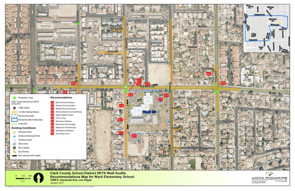
2 Overview This report summarizes existing conditions, observations and recommended improvements and programs for Gene Ward Elementary School (ES) resulting from the Safe Routes to School (SRTS) walk audit conducted on September 20, A summary map illustrates the audit location, area characteristics and locations of infrastructure recommendations. The report includes the following sections: Gene Ward Elementary School Walk Audit Summary... 2 Walk Audit Observations and Recommendations... 4 Education, Encouragement, and Enforcement Overview... 8 Walk Audit Recommendations Map School Walking Route Map This effort supports the Clark County School District (CCSD) SRTS Program, which encourages children to walk and bicycle to and from school safely. CCSD SRTS Program staff work with schools and community partners to identify improvements, programs and policies to help schools achieve their parent engagement, safety and wellness policy goals, and to make walking and bicycling viable and safe transportation options. More information on the CCSD SRTS Program is available online at: The benefits of implementing a SRTS plan are far reaching and include improving safety, encouraging physical activity and reducing traffic congestion and motor vehicle emissions. SRTS programs and projects benefit adjacent neighborhoods as well as students and their families. The 2016 SRTS walk audits were funded by the Regional Transportation Commission of Southern Nevada (RTC), with support from the Clark County School District (CCSD). The preparation of this report has been financed in part through grants from the Federal Highway Administration and Federal Transit Administration, U.S. Department of Transportation, under the Metropolitan Planning Program, Section 104(f) of Title 23, U.S. Code. The contents of this report do not necessarily reflect the official views or policy of the U.S. Department of Transportation. Wood Rodgers Alta Planning + Design
3 2 Clark County Safe Routes to School 2016 Walk Audits Gene Ward Elementary School Walk Audit Summary Date: Tuesday, September 20, 2016 Meet Time: 1:30 P.M.; observing afternoon bell Address: 1555 E Hacienda Avenue, Las Vegas, NV Weather Conditions: Clear Events/Unique Conditions: None School Type: Neighborhood Enrollment: 808 Percent Children Not Bused: ~88% Morning/Afternoon Bells: 8:00 A.M./2:11 P.M. Parental Involvement: High: Identified SRTS Parent Champion who takes an active role in planning activities & events Medium: Parents or parent group regularly participated in SRTS activities and engages around transportation issues Low: Little to no parent involvement in SRTS or transportation/safety issues Local Jurisdiction: Clark County Attendees Sherie K. Moore, CCSD Safe Routes to School Cathy Halka, Regional Transportation Commission of Southern Nevada (RTC) Lori Marker, CCSD Safe Routes to School Lonnie Wilborn, Clark County Public Works Bryan Gant, Wood Rodgers Hannah Day-Kapell, Alta Planning + Design School Layout The school building is angled and fronts both E. Hacienda Avenue and Tamarus Street. Residential land uses surround the school with the exception of a church to the south and a vacant parcel of land to the north. Maryland Parkway to the west is the closest major roadway. The parking lot in front of the school is used for staff parking, with the ingress from Tamarus Street and the egress onto E. Hacienda Avenue. Site Circulation and Access Student dismissal: Dismissal occurs through two building exits, the north building and the west building exits. Students then exit campus through either of two gates to the north or the west gate facing the parking lot. However, bus riders exit through the front building exit, and bicyclists exit through the bike corral gate on the north side. Bicycle and pedestrian circulation: Pedestrian activity is high along Tamarus Street and E. Hacienda Avenue. The majority of pedestrians cross E. Hacienda Avenue at the marked crosswalk at Tamarus Street. Little pedestrian traffic was observed heading south from campus. The apartment complexes to the north of the school are a significant destination. The bike parking area is located on the north edge of the campus, east of the building near the fence gate. Six bikes were observed in the bike corral during the audit. Three crossing guards are assigned to the E. Hacienda Avenue and Tamarus Street intersection. Passenger vehicle circulation: Parent pick-up/drop-off occurs primarily along Tamarus Street and E. Hacienda Avenue. Some pick-up activity occurs on Caliente Street to the east but less than the other locations. RTC of Southern Nevada Clark County School District
4 Gene Ward Elementary School Walk Audit Report 3 School bus circulation: Bus loading occurs in front of the school in a separate drive aisle for special education buses and along the east curb line of Tamarus Street for general buses. Bus usage consists of one general bus and seven special education buses. Bicycle and Pedestrian Crash Review: NDOT crash data review ( ) lists two pedestrian crashes within the ¼ mile walk radius from the school entrance. A review of the crash data reveals neither crash occurred near the morning or afternoon bell times. Existing Roadways Street Name E. Hacienda Avenue Tamarus Street School Use Primary access Primary Access Speed: Posted / School Zone No. of Lanes Parking School Signs 35/15 5 Prohibited Roadside school zone signs (S5-1) 25/15 2 Prohibited Roadside school zone signs (S5-1) Caliente Street N/A 25 2 Allowed N/A Wood Rodgers Alta Planning + Design


5 4 Clark County Safe Routes to School 2016 Walk Audits Walk Audit Observations and Recommendations Afternoon dismissal generally operated well. However, heavy motor vehicle congestion, double-parking, U-turns, and pedestrians walking through moving traffic occurred on Tamarus Street. Pick-up activity on E. Hacienda Avenue was also considerable with motorists making U-turns and pedestrians crossing in unmarked locations. The apartment complexes north of E. Hacienda Avenue generate significant pedestrian activity. There are three crossing guards positioned at the E. Hacienda Avenue and Tamarus Street intersection. Pedestrian activity was also observed west of campus along E. Hacienda Street. School Parking Lot and Grounds The front parking lot is used by parents for pick-up and drop-off, however, the drive aisle closest to the school is dedicated for buses only. Car drivers turning into and out of the front parking lot exacerbate congestion on both Tamarus Street and E. Hacienda Avenue and create vehicular conflicts. Blocking the parking lot entrance from Tamarus Street would eliminate these conflicts and reduce congestion. Recommendation 1.0: Block school parking lot driveway with cones prior to the dismissal bell. Turning vehicles into the school parking lot entrance increase congestion and conflicts Adjacent Streets Tamarus Street: Tamarus Street becomes congested with both vehicular traffic and pedestrians mixing during dismissal, creating numerous conflicts. Drivers park along both sides of the road. A long stretch, approximately 200- feet, of the east curb line is painted to prohibit parking in the general bus loading zone. However, the number of general buses has substantially changed over time and there is only one general bus using the loading zone. Removing the red curb paint could increase parking capacity and/or reduce driver confusion. Recommendation 2.1: Remove approximately 140-feet of red curb paint along east Tamarus Street curb bus loading zone. Unnecessary red curb paint along the east Tamarus Street sidewalk E. Hacienda Avenue: There is significant parking along E. Hacienda Avenue during dismissal, however, not to the same degree that it occurs on Tamarus Street. Drivers typically park along the south curb line both east and west of the school parking lot exit. Parking is not permitted with no parking signs present. E. Hacienda Avenue has an existing bike lane and the parked vehicles block the bike lane during dismissal. The bike lane striping is very faded and difficult for drivers to know a bike lane exists. Recommendation 2.2: Refresh E. Hacienda Avenue bike lane striping. An opportunity in lieu of Recommendation 2.2 the team discussed is to reconfigure this segment of Hacienda Avenue, from Tamarus Street to Caliente Street to provide for on-street parking with a buffered RTC of Southern Nevada Clark County School District

6 Gene Ward Elementary School Walk Audit Report 5 bike lane adjacent to the curb line. This would require a lane reduction to achieve this complete streets cross section. See the figure below for the proposed complete streets configuration. Complete Street Reconfiguration Option Sidewalk Obstructions Where the northwest corner of the school parking lot abuts the E. Hacienda Avenue sidewalk, sediment was present across the sidewalk causing a hazard. It appears the sediment was caused by stormwater runoff from the adjacent landscape area. The majority of the landscape area next to the sidewalk has decorative rock rip rap, however, the area next to the parking lot corner is missing rip rap which would help eliminate sediment runoff. Recommendation 3.1: Remove sediment on the sidewalk and replace landscape rip rap. Directly adjacent to the location of Recommendation 3.1, a section of sidewalk is heaved and creates a tripping hazard for pedestrians. Recommendation 3.2: Repair E. Hacienda Avenue sidewalk heave on the south sidewalk near the northwest corner of the school parking lot. A tree on the north edge of the campus, west of Caliente Street, is overgrown and causing a sidewalk obstruction. Recommendation 3.3: Trim up tree to minimum 8-foot height to remove obstruction. Wood Rodgers Alta Planning + Design

7 6 Clark County Safe Routes to School 2016 Walk Audits Sidewalk Additions/Repair At the southwest corner of the campus between the school and church, the sidewalk along the east side of Tamarus Street has an odd configuration consisting of a partial driveway, curb returns, a valley gutter and overgrown weeds. It is not apparent what the purpose of this configuration is as access to adjacent facilities is not provided. The odd configuration and lack of maintenance creates a tripping hazard and is not supportive of wheelchairs and/or strollers. Recommendation 4.0: Reconstruct the sidewalk to provide a clear, ADA compliant walkway and good drainage. Signing Tamarus Street signage prohibits roadside parking and there are No Parking signs along the roadway. However, parking occurs for pick-up and drop-off activities. This can be confusing and unclear for drivers. Recommendation 5.1: Remove No Parking signs to eliminate confusion. Unsafe sidewalk configuration along the east Tamarus Street sidewalk The existing Do Not Enter sign at the school parking lot exit is extremely faded and difficult to see. Recommendation 5.2: Replace Do Not Enter sign at the school parking lot exit. ADA Ramp Assessment Reviewing the ramps within the quarter-mile walk radius from the front entrance, the following additional ADA improvements have been identified: Recommendation 6.0: o E. Hacienda Avenue at Mancos Court: add tactile strips to both quadrants o E. Hacienda Avenue at Escondido Street: add tactile strips to all quadrants o E. Hacienda Avenue at Spencer Street: add tactile strips to three quadrants o Spencer Street at Mapleton Lane: add tactile strips to both quadrants Bike Parking The Ward ES bike parking area is located on the north side of the school. It seems to provide sufficient racks to accommodate all bicycles, but staff should regularly check on the cage to determine whether additional parking is necessary. When racks are replaced, new racks should comply with the Association for Bicycle and Pedestrian Professional s Bicycle Parking Guidelines. Racks should enable the bicycle frame and at least one wheel to be locked to the rack and support the bicycle in a stable position without damage to wheels, frame or components (such as U-racks on a concrete pad). Each bicycle should have a 2 ft. by 6 ft. space that is easy to access. Furthermore, the bike corral should be covered to prevent theft (Recommendation 7.0). In addition to the longer-term student parking in a cage that is locked during the day, one or two bike racks should be installed near the school s front gate for short-term parking. RTC of Southern Nevada Clark County School District
8 Gene Ward Elementary School Walk Audit Report 7 Vegetation Overgrown vegetation can reduce the effective width of the sidewalk, create a tripping hazard, or impede visibility. Parent volunteers or school staff should regularly walk around the school and review the landscaping maintenance needs, informing the appropriate agency when trimming is necessary. CCSD maintains the school grounds and adjacent sidewalks, while Clark County maintains nearby streets and sidewalks in the public right of way. Contact Clark County Code Enforcement for landscape trimming and Clark County Public Works for sidewalk maintenance. Graffiti removal requests can be submitted via the Southern Nevada Graffiti Hotline. Table 1: Summary of Infrastructure Recommendations Recommendation Description Jurisdiction Cost Estimate Ward 1.0 Block Driveway Entrance Clark County School District N/A Ward 2.1 Remove No Parking Paint Clark County School District $400 Ward 2.2 Refresh Bike Lane Striping Clark County $800 Ward 3.1 Remove Sediment and Add Rip Rap Clark County School District $200 Ward 3.2 Repair Sidewalk Heave Clark County $1,500 Ward 3.3 Trim Up Tree Clark County $200 Ward 4.0 Reconstruct Walkway Clark County $9,000 Ward 5.1 Remove No Parking Signs Clark County $300 Ward 5.2 Replace Do Not Enter Sign Clark County School District $500 Ward 6.0 ADA Ramp Improvements Clark County $2,500 Ward 7.0 Cover Bike Corral Clark County School District $2,500 Wood Rodgers Alta Planning + Design
9 8 Clark County Safe Routes to School 2016 Walk Audits Education, Encouragement, Enforcement, and Evaluation Overview Non-infrastructure activities and events complement infrastructure improvements by empowering students and their families to try walking and bicycling, and by making it safer for them to do so. At the walk audit, participants noted and observed several behavioral issues, which could be addressed through education, encouragement and enforcement activities, including parent drivers not complying with traffic laws and students and families outside of the marked crosswalk. CCSD SRTS has developed an Achievement Level Program to recognize school efforts to improve and promote safe walking and bicycling. The first step, which is recommended in all schools, is to provide bicycle and pedestrian education at each school every year. Schools are also encouraged to draft an Action Plan and identify the top two or three goals to work on. Action Plans help schools focus on the most important activities and evaluate progress on their goals. See the CCSD SRTS School Achievement Level Guide for more information. Existing Activities Ward ES has achieved First Step Status in the school year and currently participates in a variety of programs to promote safe travel around the school. Examples include but are not limited to: Hosted a Safety Assembly that informed students about walking and biking safety. Provided transportation safety announcements to the entire school through ParentLink texts, such as reminders to drive safely in the school area and watch for pedestrians. Posted Thanks for Driving Safely brochure on the school s website. Hosted a Ride for Reading event in which donated books are shared with students via bicycle. Participated in the Fire Up Your Feet. Recommended SRTS Programs As a CCSD SRTS First Step school, Ward ES is already involved in several outreach and encouragement programs. This Walk Audit and the school s Action Plan are key elements of moving to the Bronze Achievement Level. Staff should communicate the school s SRTS Action Plan and programs to parents, staff, and administration and post the action plan on the school s website. Ward ES staff can expand parent education and outreach through parent workshops or educational events. The school can participate in the CCSD SRTS Thank You For Driving Safely (formerly known as the Positive Presence program), which encourages safe driving in the school zone and pedestrians and bicyclists to follow the rules of the road. In addition, SRTS Champions should consider participating in encouragement activities such as AAA School Safety Patrol program and conducting student hand tallies. The activities below are recommended for Ward ES to improve and promote safe walking and bicycling to and from school and in the community. They can be implemented by school administrators, teachers, parents or even school clubs, to promote walking and bicycling safely to and from school. CCSD SRTS offers resources, outreach, and technical assistance and can provide presentations and workshops tailored to the school s needs. Contact program staff at srts@interact.ccsd.net for more information about these resources. RTC of Southern Nevada Clark County School District


10 Gene Ward Elementary School Walk Audit Report 9 Recommended Programs Parent Education and Outreach Parents are the primary decision-makers about how their children get to school. Informing parents about their options for walking and bicycling, as well as communicating the benefits of active transportation, can encourage more families to walk and bike. This can occur through school e-news or announcements, and through informational resources. Suggested route maps can show parents the best walking or biking route to the school, overcoming concerns about barriers. Clark County has an existing route map available here and an updated map is available on Page 14 below. Resources and best practice programs: Parent education communicates the benefits of active transportation and encourages parents to get involved in SRTS activities The CCSD SRTS program offers workshops and presentations to parents that can be tailored to the school community s needs. The National Center for SRTS has several tip sheets for parents on safe walking and bicycling behaviors. The Institute of Transportation Engineers (ITE) has a white paper on School Route Maps. o The City of Henderson provides similar maps that include pedestrian, bicycle, and driver safety tips. o Pico Rivera, CA developed user-friendly Suggested School Route Maps that include walking times and location of bicycle parking. Fire Up Your Feet Fire Up Your Feet is a national campaign aimed at increasing physical activity. The website provides outreach materials and educational resources for the Fire Up Your Feet campaign that occurs over one month in the spring and the fall. The website helps classrooms track the number of times they walk, bike, carpool or take transit to school. Students and classrooms with the highest percentage of students walking, biking or carpooling compete for prizes. Resources and best practice programs: Fire Up Your Feet encourages physical activity through a competitive program Nevada s Fire Up Your Feet program includes promotional resources and an activity tracker, funded through the Southern Nevada Health District and Anthem Blue Cross and Blue Shield Foundation. Schools in the CCSD SRTS program can win cash prizes as well as bike parking racks, and are eligible for national awards. Wood Rodgers Alta Planning + Design


11 10 Clark County Safe Routes to School 2016 Walk Audits Nevada Moves Day, Walk to School Day, and Bike to School Day Nevada Moves Day, Walk to School Day, and Bike to School Day are events that celebrate students walking and bicycling to school. Nevada Moves Day is held in March as part of Nevada Moves Week, while Walk to School Day is usually the first Wednesday in October, and Bike to School day takes place the second week in May. Parents can set up a table on the event day to provide refreshments and small rewards for families who participate, as well as maps, lights, and safety information to encourage more students and families to join in the fun. Nevada Moves Day is a statewide event that celebrates the benefits of walking and bicycling to and from school Resources and best practices: The CCSD Safe Routes to School program and NDOT supports Nevada Moves Day by providing a box of promotional materials to the first 50 schools that sign up to participate. Walk Bike to School suggests event ideas and planning resources for encouraging active transportation at schools. The National Center for SRTS maintains a national database of walk and bike to school day events as well as event ideas and planning resources. School Zone Traffic Safety Campaign A School Zone Traffic Safety Campaign creates awareness of students walking and bicycling to school. A safety campaign is an effective way to reach the general public and encourage drivers to slow down and look for students walking and biking to school. A School Zone Traffic Safety Campaign uses signs and banners located near schools (for example, in windows of businesses, yards of people s homes and print publications) to remind drivers to slow down and use caution in school zones. This campaign can be kicked off at the start of each school year or in conjunction with special events, such as Walk to School Day, Bike to School Day or Nevada Moves Day. Resources and best practice programs: Safety campaigns remind drivers to slow down and watch for people on foot and bike San Jose Street Smarts campaign encourages drivers, cyclists, and pedestrians to get smarter about traffic safety. Bikes Belong has a Review of Bicycle Safety Campaigns with examples from throughout the US. Pasadena, CA launched a Safe School Zones bilingual campaign encouraging drivers to slow down. Volunteers in Arizona conducted a Neighborhood Speed Watch routine detection event which assisted law enforcement efforts, putting serial speeders on notice and bringing down average speeds. RTC of Southern Nevada Clark County School District


12 Gene Ward Elementary School Walk Audit Report 11 AAA School Safety Patrol Elementary and middle school aged volunteers can sign-up to become a certified AAA School Safety Patroller. With support and leadership from school faculty and parents, student patrollers help fellow students develop a better understanding of pedestrian and vehicular traffic hazards. CCSD has partnered with AAA and ten schools across the district have participated. Participating schools can receive up to $250 for materials and incentives to help tailor the program to the school s needs. Resources and best practice programs: AAA has School Safety Patrol membership information and description of student, teacher, and parent roles. McWilliams ES partnered with AAA staff during a Walking School Bus, handed out incentives on Nevada Moves Day, and assisted with McWilliams Family Fitness Night. Rogers ES worked with AAA to build a 5th grade leadership program where the students teach other students about bus, pedestrian and bicycle safety. Student Clubs and Youth Leadership Programs Clubs and leadership programs allow older students to form groups to support the causes they care about most. Student clubs can host Nevada Moves Day, organize a competition, or work with their peers to promote walking and bicycling. Student clubs can offer excellent ideas, provide exceptional energy and drive to get things done. Resources and best practice programs: CCSD schools Lunt ES and Kitty Ward ES have successfully piloted a 5th grade leadership program where the students are trained to conduct a bike rodeo for their school. Lunt ES holds several small bike rodeos for other students to participate by grade level, while Kitty Ward's students run a schoolwide bike rodeo, then holds several Saturday family bike rides throughout the year. Create a Cycling League or club, Leagues can introduce student riders to the sport of mountain biking or road racing, with a focus on skills, fun, fitness, and responsibility. Student Hand Tallies Certified School Safety Patrollers inform students of potential pedestrian and vehicle traffic dangers Teens can support Safe Routes activities through clubs and youth leadership programs Hand tallies are a standard way of tracking school commute mode split for SRTS programs. Students are asked how they got to and from school over a 2-3 day period. Students raise their hand when the mode Wood Rodgers Alta Planning + Design
13 12 Clark County Safe Routes to School 2016 Walk Audits they took is called out, and the teacher or a volunteer records this. Hand tallies are often required of state and federal SRTS grant recipients. Resources and best practice programs: CCSD SRTS encourages all schools to collect hand tallies every other year, offset from the parent survey data collection. The National Center for SRTS provides forms, data collection guidelines, data center, and automatically-generated reports. RTC of Southern Nevada Clark County School District
14 Walk Audit Recommendations Map

15 14 Clark County Safe Routes to School 2016 Walk Audits School Walking Route Map RTC of Southern Nevada Clark County School District
2 Mark Twain Elementary School Report
 2 Mark Twain Elementary School Report Principal: Greg Kaatz Grades: K-2 Enrollment: 323 Address: 425 N. Church Street First bell: 8:10 a.m. Silverton, OR 97381 Last bell: 2:30 p.m. Free & Reduced Lunch:
3 Silverton High School Report
 3 Silverton High School Report Principal: Justin Lieuallen Grades: 9-12 Enrollment: 1,277 Address: 1456 Pine Street First bell: 7:55 a.m. Silverton, OR 97381 Last bell: 3:05 p.m. Free & Reduced Lunch:
July 5, Arthur R. Ware, Jr. Elementary School 2017 Safe Routes to School Walkabout Report
 July 5, 2017 Arthur R. Ware, Jr. Elementary School 2017 Safe Routes to School Walkabout Report 1 Walkabout Report Introduction On April 28, 2017, City, School, and SAWMPO staff met to conduct a Safe Routes
SAFE ROUTES TO SCHOOL
 SAFE ROUTES TO SCHOOL Edgewood Elementary School Existing Conditions and ACTION PLAN > Oak Creek - Franklin Joint School District Table of Contents CONTEXT Enrollment Boundaries Enrollment
Vallecito Elementary School. Travel Plan
 Vallecito Elementary School Travel Plan TABLE OF CONTENTS 1. PURPOSE... 1 1.1. SR2S PLANNING, IMPLEMENTATION AND MONITORING... 1 1.2. MARIN COUNTY MEASURE A... 1 2. VALLECITO ELEMENTARY SCHOOL PROFILE...
SAFE ROUTES TO SCHOOL
 SAFE ROUTES TO SCHOOL Forest Ridge Elementary School Existing Conditions and ACTION PLAN > Oak Creek - Franklin Joint School District Table of Contents CONTEXT Enrollment Boundaries
CITY OF OAK CREEK SAFE ROUTES TO SCHOOL ACTION PLAN. East Middle School
 CITY OF OAK CREEK SAFE ROUTES TO SCHOOL ACTION PLAN East Middle School CITY OF OAK CREEK SAFE ROUTES TO SCHOOL ACTION PLAN East Middle School Why Safe Routes to School? Safe Routes to School ( SRTS ) is
Hedgepeth Williams Middle School and Paul Robeson Elementary School Trenton, NJ. School Travel Plan
 Hedgepeth Williams Middle School and Paul Robeson Elementary School Trenton, NJ School Travel Plan Hedgepeth Williams Middle School Description: Hedgepeth-Williams Middle School is located at 301 Gladstone
Chapter 2. Bellingham Bicycle Master Plan Chapter 2: Policies and Actions
 Chapter 2 Bellingham Bicycle Master Plan Chapter 2: Policies and Actions Chapter 2: Policies and Actions The Bicycle Master Plan provides a road map for making bicycling in Bellingham a viable transportation
Arlington Public Schools Thomas Jefferson Site Evaluation Transportation Networks. Thomas Jefferson Working Group Meeting #6 November 10, 2014
 Arlington Public Schools Thomas Jefferson Site Evaluation Transportation Networks Thomas Jefferson Working Group Meeting #6 November 10, 2014 2 3 INTRODUCTION 4 Goal of our work: Identify and assess multi-modal
C/CAG. Sunnybrae Elementary School Walking and Bicycling Audit. San Mateo-Foster City School District JUNE 2013
 Sunnybrae Elementary School Walking and Bicycling Audit JUNE 2013 San Mateo-Foster City School District C/CAG City/County Association of Governments of San Mateo County SUNNYBRAE ELEMENTARY SCHOOL WALKING
Agenda. Overview PRINCE GEORGE S PLAZA METRO AREA PEDESTRIAN PLAN
 PRINCE GEORGE S PLAZA METRO AREA PEDESTRIAN PLAN May 28, 2008 Agenda Welcome and introductions Project overview and issue identification Planning context and strengths Design challenges and initial recommendations
Active Transportation Facility Glossary
 Active Transportation Facility Glossary This document defines different active transportation facilities and suggests appropriate corridor types. Click on a facility type to jump to its definition. Bike
Orange Center Elementary School
 Drag and drop pic and stretch/crop to the limits of the blue rectangle (delete this text box) Orange Center Elementary School Drag and drop pic and stretch/crop to the limits of the blue rectangle (delete
Bringing together community and health. Physical Activity and Nutrition Unit Office of Statewide Health Improvement Initiatives
 Bringing together community and health. Physical Activity and Nutrition Unit Office of Statewide Health Improvement Initiatives Physical Activity and Nutrition Unit Office of Statewide Health Improvement
Sebastopol Charter School Traffic Management Plan
 Sebastopol Charter School The serves as the working document in support of these essential goals: to ensure the safety and efficiency of student arrival to and departure from school to ensure the safety
PRINCE GEORGE S PLAZA METRO AREA PEDESTRIAN PLAN
 PRINCE GEORGE S PLAZA METRO AREA PEDESTRIAN PLAN May 28, 2008 Agenda Welcome and introductions Project overview and issue identification Planning context and strengths Design challenges and initial recommendations
Rim Rock Elementary School Walking and Biking Audit
 Rim Rock Elementary School Walking and Biking Audit September 29, 2016 Rim Rock Elementary School Audit for Walking and Biking September 29, 2016 Audit Team Members: Sam Atkins, City Engineer, City of
LTAC: Katie Mencarini, Central & Hampton Roads streets and a fifteen minute debrief to discuss the findings. Participants walked along Mill Road
 Walkabout Summary On June 3, 2013, five participants met at Glen Allen Elementary School in Glen Allen, Virginia to take a closer look at the walking and biking network around the school. In addition to
James Williams Middle School 915 Acacia Lane
 James Williams Middle School 915 Acacia Lane Grades Served: 6 th -8 th Student Geography According to an address analysis of students, 36.7% of students attending JWMS live within 2 miles of school (see
5. RUNNINGWAY GUIDELINES
 5. RUNNINGWAY GUIDELINES These guidelines should be considered collectively when making runningway decisions. A runningway is the linear component of the transit system that forms the right-of-way reserved
Corpus Christi Metropolitan Transportation Plan Fiscal Year Introduction:
 Introduction: The Safe, Accountable, Flexible, Efficient Transportation Equity Act: A Legacy for Users (SAFETEA-LU) has continued the efforts started through the Intermodal Surface Transportation Efficiency
Traffic Impact Memorandum. May 22, 2018
 BISHOP PROFESSIONAL DEVELOPMENT BUILDING Proposed Land-use Change & Parking Modification 3601 SW 31st Street Topeka, Kansas 66614 CFS Project No. 185077 Traffic Impact Memorandum May 22, 2018 Prepared
Introduction Additional Safe Routes to School Resources Main Street Elementary School Survey Results Field Audit...
 Contents Introduction... 2 Additional Safe Routes to School Resources... 2... 3 Survey Results... 4 Field Audit... 6 Proposed Safe Routes to School Elements... 9 Typical Safe Routes to School Summary...
Safe Routes to School Action Plan Aberdeen, Idaho
 Background Aberdeen, Idaho is a largely agricultural community of nearly 2,000 people and is located in the southeast portion of the state on the western edge of American Falls Reservoir. The community
Bicycle Best Practices: Goals and Priorities for Education and Promotion Efforts
 Bicycle Best Practices: s and Priorities for Education and Promotion Efforts The following education and promotion goals were identified by Salt Lake County as high priorities for the region. 1: Teach
CURBSIDE ACTIVITY DESIGN
 5 CURBSIDE ACTIVITY DESIGN This chapter provides design guidance for separated bike lanes adjacent to curbside activities including parking, loading and bus stops. Typical configurations are presented
Safe Routes to School Comprehensive Plan
 Safe Routes to School Comprehensive Plan City of Apple Valley Dakota County, MN May 2010 Prepared by: Project Background The Statewide Health Improvement Program (SHIP) aims to help Minnesotans live longer,
Arlington Public Schools New Elementary School at Thomas Jefferson Site Off-Site Transportation. Thomas Jefferson BLPC / PFRC Meeting July 27, 2016
 Arlington Public Schools New Elementary School at Thomas Jefferson Site Off-Site Transportation Thomas Jefferson BLPC / PFRC Meeting July 27, 2016 1.Review of Analysis 2.Key Transportation Issues 3.Recommendations
MAG Town of Cave Creek Bike Study Task 6 Executive Summary and Regional Significance Report
 Page 1 MAG Town of Cave Creek Bike Study Task 6 Executive Summary and Regional Significance Report August 1, 2012 MAG Project #481 Page 2 Task 6 Executive Summary and Regional Significance Report Introduction
EUCLID AVENUE PARKING STUDY CITY OF SYRACUSE, ONONDAGA COUNTY, NEW YORK
 EUCLID AVENUE PARKING STUDY CITY OF SYRACUSE, ONONDAGA COUNTY, NEW YORK CITY OF SYRACUSE DEPARTMENT OF PUBLIC WORKS 1200 CANAL STREET EXTENSION SYRACUSE, NEW YORK 13210 DRAFT REPORT DATE: November 13,
Windy Ridge Elementary School
 Windy Ridge Elementary School SCHOOL ROUTE PLAN For WINDY RIDGE ELEMENTARY SCHOOL LOCATION 54 ORANGE COUNTY Prepared for: ORANGE COUNTY SCHOOL ASSESSMENT PROGRAM ORANGE COUNTY PUBLIC WORKS Traffic Engineering
Implementing the Three Es of School Zone Traffic Calming
 Implementing the Three Es of School Zone Traffic Calming Use this evaluation tool as a guide to analyze the specific safety needs of your school. SCHOOL PROFILE School Name: School District: Address: Phone
TRAFFIC CALMING GUIDE FOR TORONTO CITY OF TORONTO TRANSPORTATION SERVICES DIVISION
 TRAFFIC CALMING GUIDE FOR TORONTO CITY OF TORONTO TRANSPORTATION SERVICES DIVISION CITY OF TORONTO TRANSPORTATION SERVICES DIVISION 2016 TRAFFIC CALMING GUIDE FOR TORONTO TABLE OF CONTENTS Introduction
Improvements Infrastructure Gap Assessment and Improvements Street Striping
 Infrastructure Project Proposal The federal-aid Safe Routes to School program funds infrastructure/engineering projects that fall into two categories: Design (available only to School Development Authority
Monument Elementary School Trenton, NJ School Travel Plan
 Monument Elementary School Trenton, NJ School Travel Plan Prepared by Greater Mercer TMA With Assistance from Alan M. Voorhees Transportation Center; Rutgers, The State University of New Jersey and NJ
Item to be Addressed Checklist Consideration YES NO N/A Required Description Complete Streets Guidelines
 Passaic County Complete Streets Checklist - Concept Development Project Name Item to be Addressed Checklist Consideration YES NO N/A Required Description Complete Streets Guidelines Existing Plans Have
THE OFFICIAL GUIDE TO CYCLING SAFELY IN PHILADELPHIA
 B IKE NICE THE OFFICIAL GUIDE TO CYCLING SAFELY IN PHILADELPHIA A partnership of the City of Philadelphia and the Bicycle Coalition of Greater Philadelphia ABOUT VISION ZERO & BIKE NICE It s a great day
Broad Street Bicycle Boulevard Design Guidelines
 Broad Street Bicycle Boulevard Design Guidelines Building from the strategies introduced in the 2013 Bicycle Transportation Plan and community input received thus far, City Transportation Staff have identified
San Ramon Elementary School. Travel Plan
 San Ramon Elementary School Travel Plan TABLE OF CONTENTS 1. PURPOSE... 1 1.1. SR2S PLANNING, IMPLEMENTATION AND MONITORING... 1 1.2. MARIN COUNTY MEASURE A... 1 2. SAN RAMON ELEMENTARY SCHOOL PROFILE...
APPENDIX A: Complete Streets Checklist DRAFT NOVEMBER 2016
 APPENDIX A: Complete Streets Checklist DRAFT NOVEMBER 2016 Complete Streets Checklist MetroPlan Orlando s Complete Streets Checklist is an internal planning tool for staff to further implementation of
o n - m o t o r i z e d transportation is an overlooked element that can greatly enhance the overall quality of life for the community s residents.
 N o n - m o t o r i z e d transportation is an overlooked element that can greatly enhance the overall quality of life for the community s residents. 84 Transportation CHAPTER 11 INTRODUCTION Transportation
Merrick and Memorial Neighborhood Study 5/14/2014 Public Meeting
 Merrick and Memorial Neighborhood Study 5/14/2014 Public Meeting Study Area April 9 Public Meeting Comments Summary Pedestrian Safety - A Walking Neighborhood Pedestrian traffic is very difficult A need
Summary Report School Walking & Bicycling Audits. Mesa County Regional Transportation Planning Office
 Summary Report School Walking & Bicycling Audits Mesa County Regional Transportation Planning Office This page left blank intentionally WALKING & BICYCLING AUDIT SUMMARY 2 Executive Summary Background:
Appendix T CCMP TRAIL TRAFFIC & TRANSPORTATION DESIGN STANDARD
 Appendix T CCMP 3.3.4 TRAIL TRAFFIC & TRANSPORTATION DESIGN STANDARD 3.3.4 Trail Traffic and Transportation Design Multi-use trails have certain design standards, which vary depending on the agency that
Drag and drop pic and stretch/crop to the limits of the blue rectangle (delete this text box) Maxey Elementary School
 Maxey Elementary School") Drag and drop pic and stretch/crop to the limits of the blue rectangle (delete this text box) Maxey Elementary School SCHOOL ROUTE PLAN For MAXEY ELEMENTARY SCHOOL LOCATION 33 ORANGE COUNTY Prepared for:
Drag and drop pic and stretch/crop to the limits of the blue rectangle (delete this text box) Maxey Elementary School SCHOOL ROUTE PLAN For MAXEY ELEMENTARY SCHOOL LOCATION 33 ORANGE COUNTY Prepared for:
CONNECTING PEOPLE TO PLACES
 CONNECTING PEOPLE TO PLACES 82 EAST BENCH MASTER PLAN 07 Introduction The East Bench transportation system is a collection of slow moving, treelined residential streets and major arteries that are the
Appendix C. TRAFFIC CALMING PROGRAM TOOLBOX
 Appendix C. TRAFFIC CALMING PROGRAM TOOLBOX PHASE I...2 Do Not Enter Sign...3 One-Way Sign...4 Turn Prohibition...5 Pavement Markings...6 Speed Monitoring Trailer...7 Neighborhood Speed Watch...8 Police
Bicycle Master Plan Goals, Strategies, and Policies
 Bicycle Master Plan Goals, Strategies, and Policies Mobilizing 5 This chapter outlines the overarching goals, action statements, and action items Long Beach will take in order to achieve its vision of
Meadow Woods Elementary School
 Drag and drop pic and stretch/crop to the limits of the blue rectangle (delete this text box) Meadow Woods Elementary School Drag and drop pic and stretch/crop to the limits of the blue rectangle (delete
10.0 CURB EXTENSIONS GUIDELINE
 10.0 CURB EXTENSIONS GUIDELINE Road Engineering Design Guidelines Version 1.0 March 2017 City of Toronto, Transportation Services City of Toronto Page 0 Background In early 2014, Transportation Services
9/21/2016 VIA . RE: The Knot (DR16-270)
") 9/21/2016 VIA EMAIL Garrett Norman, Assistant Planner City of Sacramento Community Development Department 300 Richards Boulevard, 3 rd Floor Sacramento, CA 95811 RE: The Knot (DR16-270) Dear Mr. Norman:
9/21/2016 VIA EMAIL Garrett Norman, Assistant Planner City of Sacramento Community Development Department 300 Richards Boulevard, 3 rd Floor Sacramento, CA 95811 RE: The Knot (DR16-270) Dear Mr. Norman:
EXECUTIVE SUMMARY. Vision
 Vision Walking and bicycling in Salt Lake City will be safe, convenient, comfortable, and viable transportation options that connect people to places, foster recreational and economic development opportunities,
Lawrence Safe Routes to School. Community Meeting January 14, 2015
 Lawrence Safe Routes to School Community Meeting January 14, 2015 Safe Routes to School The 6 E s Education Encouragement Enforcement Engineering Evaluation Equity What are the elements of a SRTS plan?
Mission-Geneva Transportation Study Community Workshop 2 July 8, 2006
 Community Workshop 2 July 8, 2006 Small Group Workbook 1 Basic Improvements on Mission Street Streetscape. Pedestrian-scale lighting; landscaping; community art on utility boxes; more (possibly unique)
Double the amount of bicycle ridership while at the same time reducing the number of bicycle crashes by one-third.
 CHAPTER 6 Recommended Policies and Action Items To achieve the goals stated in Chapter 1 and guide implementation of the Bicycle Plan, policies and action items have been identified. They are presented
NM-POLICY 1: Improve service levels, participation, and options for non-motorized transportation modes throughout the County.
 Transportation PRINCE WILLIAM COUNTY 2008 COMPREHENSIVE PLAN NON-MOTORIZED PLAN CONTENTS Goals, Policies, and Action Strategies Table 4 (Bike Facility Classifications and Descriptions) Table 5 (Bike Facility
Walkabout Summary Report
 Walkabout Summary Report Introduction On September 3, 2014, stakeholders at Bessie Weller Elementary School (Bessie Weller ES) in Staunton, Virginia met to examine the walking and bicycling network around
Comments EXECUTIVE SUMMARY
 Comments 1. Under any Alternatives, MCDOT should provide better at-grade pedestrian crossing of Georgia Avenue and Forest Glen Road, including improved crosswalks with wider medians and adequate signal
Why Zone In on Speed Reduction?
 Learn it. Do it. Live it! SPEED REDUCTION IN THE ZONE Why Zone In on Speed Reduction? Speeding is a serious issue that plays a major role in the risk of serious injury and pedestrian fatality in a crash.
MEMORANDUM. Earl Haugen and UND Transportation and Traffic Coordination Committee
 SRF No. 7766 MEMORANDUM TO: FROM: Earl Haugen and UND Transportation and Traffic Coordination Committee Rick Lane, P.E. DATE: November 26, 2013 SUBJECT: UNIVERSITY AVE REVIEW Our review of the University
CHAPTER 3: Vision Statement and Goals
 Davidson Walks & Rolls: Active Transportation Master Plan CHAPTER 3 Contents: Overview Vision Statement Measurable Goals Public Outreach CHAPTER 3: Vision Statement and Goals Overview The vision statement
Bikeway action plan. Bicycle Friendly Community Workshop March 5, 2007 Rochester, MN
 Bikeway action plan Summary The was held on March 5, 2007 at the Rochester Mayo Civic Center. The workshop was hosted by Rochester-Olmsted County Planning Department in collaboration with the League of
About the Studio. Edward J. Bloustein School of Planning and Public Policy - Rutgers University
 About the Studio Edward J. Bloustein School of Planning and Public Policy - Rutgers University Purpose of studio: Help City of Bayonne apply for Safe Routes to School (SRTS) funding by producing a School
Lake Whitney Elementary School
 Lake Whitney Elementary School SCHOOL ROUTE PLAN For LAKE WHITNEY ELEMENTARY SCHOOL LOCATION 18 ORANGE COUNTY Prepared for: ORANGE COUNTY SCHOOL ASSESSMENT PROGRAM ORANGE COUNTY PUBLIC WORKS Traffic Engineering
Chapter 3.5 Osteen Elementary School. Volusia County MPO. November 2008
 Chapter 3.5 Osteen Elementary School Osteen, FL Volusia County MPO November 2008 Volusia County MPO School Bicycle and Pedestrian Review Study, Phase 3B School Summary Osteen Elementary School is located
COWETA HIGH SCHOOL AND EAST HIGHWAY 51
 COWETA HIGH SCHOOL AND EAST HIGHWAY 51 Lack of sidewalks along Ben Lumpkin Rd. Lack of crosswalks and ramps at intersection. Hwy 51 is wide to cross as a pedestrian. No ADA compliance or connection to
Madison Urban Area and Dane County. Bicycle Transportation Plan Summary. September Introduction. Bicycle Plan Scope and Planning Process
 Bicycle Transportation Plan Summary Madison Urban Area and Dane County Introduction September 2000 Bicycling is an important mode of transportation in the Madison urban area and countywide that is available
Goodlettsville Bicycle and Pedestrian Plan Executive Summary
 Goodlettsville Bicycle and Pedestrian Plan July 2010 In Cooperation with the Nashville Area Metropolitan Planning Executive Organization Summary Introduction Progressive and forward thinking communities
Introduction.
 2307-1.0. Introduction. Delaware s Safe Routes to School (SRTS) Program was established September 10, 2002 when Governor Ruth Ann Minner signed Senate Bill 353 of the 141st General Assembly of Delaware
ROUNDABOUTS/TRAFFIC CIRCLES
 GENERAL 1. Description This standard identifies minimum requirements that shall be met for Roundabouts and Neighborhood Traffic Circles in the design and construction of elements for Arlington County Horizontal
7/23/2017 VIA . Michael Hanebutt City of Sacramento Community Development Department 300 Richards Boulevard, 3 rd Floor Sacramento, CA 95811
 7/23/2017 VIA EMAIL Michael Hanebutt City of Sacramento Community Development Department 300 Richards Boulevard, 3 rd Floor Sacramento, CA 95811 RE: 65 th Street Apartments (DR17-220) Dear Mr. Hanebutt:
Existing Transportation System
 < Open for Additional Text Transportation System Existing Transportation System This section describes vehicular transportation associated with Children s. transportation are described in a separate section
AGENDA. 5. Next Steps a. Survey Distribution b. Draft Action Plan/Recommendations c. Review at next meeting in advance of document preparation
 Congdon Elementary Safe Routes to School Plan Update SRTS Team Meeting #2-Walk Audit March 21, 2018, 3:00 p.m. Congdon Elementary School Art Room-Duluth, MN 1. Welcome and Introductions 2. SRTS Review
Proposed. City of Grand Junction Complete Streets Policy. Exhibit 10
 Proposed City of Grand Junction Complete Streets Policy Exhibit 10 1 City of Grand Junction Complete Streets Policy Vision: The Complete Streets Vision is to develop a safe, efficient, and reliable travel
City of Davis East Covell Corridor Plan
 Community Open House #2 January 22, 2014 6:00 8:00 p.m. Veterans Memorial Center, Club Room City of Davis Introduction The (ECCP) is a taking a comprehensive look at the existing transportation systems
SRTS Programs That Increase Walking and Bicycling to School
 Getting Results: SRTS Programs That Increase Walking and Bicycling to School SafeRoutes National Center for Safe Routes to School Communities initiate Safe Routes to School (SRTS) programs for a variety
Grandview Heights Safe Routes to School School Travel Plan Ohio Department of Transportation, District 6 February 23, 2012
 Grandview Heights Safe Routes to School School Travel Plan Ohio Department of Transportation, District 6 February 23, 2012 Grandview Heights School Travel Plan (STP) Safe Routes to School Table of Contents
8/31/2016 VIA . RE: Freeport Arco Fuel Station (P16-039)
") 8/31/2016 VIA EMAIL Garrett Norman, Assistant Planner City of Sacramento Community Development Department 300 Richards Boulevard, 3 rd Floor Sacramento, CA 95811 RE: Freeport Arco Fuel Station (P16-039)
8/31/2016 VIA EMAIL Garrett Norman, Assistant Planner City of Sacramento Community Development Department 300 Richards Boulevard, 3 rd Floor Sacramento, CA 95811 RE: Freeport Arco Fuel Station (P16-039)
5/7/2013 VIA . RE: University Village Safeway Expansion (P13-019)
") 5/7/2013 VIA EMAIL David Hung, Associate Planner Community Development Department, Current Planning Division City of Sacramento 300 Richards Boulevard, 3 rd Floor Sacramento, CA 95811 RE: University Village
5/7/2013 VIA EMAIL David Hung, Associate Planner Community Development Department, Current Planning Division City of Sacramento 300 Richards Boulevard, 3 rd Floor Sacramento, CA 95811 RE: University Village
Safe Routes to School Comprehensive Plan
 Safe Routes to School Comprehensive Plan City of Rosemount Dakota County, MN June 2010 Prepared by: Project Background The Statewide Health Improvement Program (SHIP) aims to help Minnesotans live longer,
Chicago Pedestrian and Bicycle Safety Initiative Final Report
 1 Chicago Pedestrian and Bicycle Safety Initiative Final Report Chicago Department of Transportation www.chicagocompletestreets.org 312.744.8147 Executive Summary Since 2001, the Chicago Department of
Item No. 14 Town of Atherton
 Item No. 14 Town of Atherton CITY COUNCIL STAFF REPORT CONSENT AGENDA TO: THROUGH: FROM: HONORABLE MAYOR AND CITY COUNCIL GEORGE RODERICKS, CITY MANAGER MICHAEL KASHIWAGI, COMMUNITY SERVICES DIRECTOR MARTY
CHAPTER 16 PEDESTRIAN FACILITIES DESIGN AND TECHNICAL CRITERIA TABLE OF CONTENTS
 CHAPTER 16 PEDESTRIAN FACILITIES DESIGN AND TECHNICAL CRITERIA TABLE OF CONTENTS Section Title Page 16.1 General... 16-1 16.1.1 AASHTO Reference... 16-1 16.1.2 ADA Requirements... 16-1 16.2 Sidewalks...
Chapter 4.3 Enterprise Elementary. Volusia County MPO. March Page 7.0
 Chapter 4.3 Enterprise Elementary Enterprise, FL Volusia County MPO March 2008 Page 7.0 Volusia County MPO Bicycle and Pedestrian School Safety Review Study Introduction Enterprise Elementary School is
Grove Hall Business District Parking Analysis
 Grove Hall Business District Parking Analysis February 2014 Prepared for The Roxbury Great Neighborhoods Partnership Nuestra Comunidad Development Corporation Dudley Square Main Streets Greater Grove Hall
PROSPECT ELEMENTARY GIRARD INTERMEDIATE GIRARD JUNIOR HIGH
 PROSPECT ELEMENTARY GIRARD INTERMEDIATE GIRARD JUNIOR HIGH SAFE ROUTES TO SCHOOL SCHOOL TRAVEL PLAN January 8, 2014 2 SECTION 1: OUR SCHOOLS School District School Name School Address Grades served Girard
Sunset Park Center for Accelerated Studies
 Sunset Park Center for Accelerated Studies The following are a simple list of advantages, disadvantages, and recommendations based on a community assessment. It is not intended to be a list of complete
S A F E R O U T E S T O S C H O O L H E R M A N TOW N S C H O O L S A N D P R O C TO R S C H O O L S P L A N A P P R OVA L S
 S A F E R O U T E S T O S C H O O L H E R M A N TOW N S C H O O L S A N D P R O C TO R S C H O O L S P L A N A P P R OVA L S WHAT IS SAFE ROUTES TO SCHOOL? In 1969, nearly 50% of children walked or rode
Chapter 2: Standards for Access, Non-Motorized, and Transit
 Standards for Access, Non-Motorized, and Transit Chapter 2: Standards for Access, Non-Motorized, and Transit The Washtenaw County Access Management Plan was developed based on the analysis of existing
Venetia Valley Elementary School. Travel Plan
 Venetia Valley Elementary School Travel Plan TABLE OF CONTENTS 1. PURPOSE... 1 1.1. SR2S PLANNING, IMPLEMENTATION AND MONITORING... 1 1.2. MARIN COUNTY MEASURE A... 1 2. VENETIA VALLEY ELEMENTARY SCHOOL
Traffic Circulation & Pedestrian Safety Study
 Lyons Township High School North Campus La Grange, Illinois Parking Lot Vaughan Building N Main Building Prepared for: Prepared by: July 23, 2015 Contents List of Figures, iii 1. Introduction...1 2. Existing
Non-Motorized Transportation 7-1
 Non-Motorized Transportation 7-1 Transportation facilities no longer mean just accommodating a vehicle powered by a combustion engine. Pedestrian and non-motorized facilities are important modes of travel
See Figure 38, Existing Nonmotorized Connections.
 Nonmotorized Connections Existing Nonmotorized Connections Pedestrian, vehicle and bike traffic access and movements are confined primarily to Penny Drive on campus. Due to the steep slope along the length
Complete Streets Funding Program Project Prioritization Plan
 Funding Program Project Prioritization Plan Location and Type Needs South Street Crosswalk Installation Stripe a new formalized crosswalk across South Street at the Anne T. Dunphy School pedestrian path
Chapter 3.3 Horizon Elementary School. Volusia County MPO. June 2009
 Chapter 3.3 Horizon Elementary School Port Orange, FL Volusia County MPO June 2009 Volusia County MPO School Bicycle and Pedestrian Review Study, Phase 3C School Summary Horizon Elementary School is located
ACTIVE TRANSPORTATION
 ACTIVE TRANSPORTATION Mobility 2040 Supported Goals Improve the availability of transportation options for people and goods. Support travel efficiency measures and system enhancements targeted at congestion
OCEAN DRIVE ELEMENTARY SCHOOL
 OCEAN DRIVE ELEMENTARY SCHOOL North Myrtle Beach, SC Safe Routes to School Travel Plan JANUARY 2017 SRTS Team Roster SRTS Team members represent key community stakeholders, share work of developing the
New Measure A Expenditure Categories DEFINITIONS OF ELIGIBLE EXPENDITURES Adopted March 8, 2007
 New Measure A Expenditure Categories DEFINITIONS OF ELIGIBLE EXPENDITURES Adopted March 8, 2007 City Street and County Road Maintenance Program The preservation and keeping of public street and road rights-of-way
National Safe Routes to School Program: Initial Results
 National Safe Routes to School Program: Initial Results Lauren Marchetti National Center for Safe Routes to School 9 th Annual New Partners for Smart Growth Thursday, February 4, 2010 Seattle, WA August