Other useful information Nearest Refreshments: In the Victoria Inn or the Lugger Inn, in Chickerell OS Explorer Map: OL15 (Purbeck and South Dorset)
|
|
|
- Pierce Johnston
- 5 years ago
- Views:
Transcription


1

2


3

4

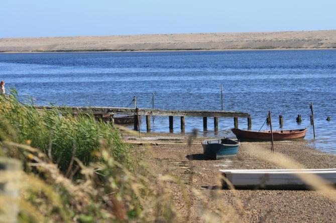
5 they find the diamond, and then to Holland, where they try to sell it, finding themselves in worse trouble than ever as a result. It is ten years before John returns to Moonfleet, fortuitously being shipwrecked on Chesil Beach while on his way to a prison in Java. Elzevir is drowned while saving John's life, but John is reunited with his childhood sweetheart, Grace (who has looked out for him every day from the garden of Moonfleet Manor), inherits the wicked but repentant Dutch diamond merchant's estate, and ends his days as JP of Moonfleet. 9. Retracing your steps to the Coast Path, turn right and continue around the Fleet Lagoon. Please take note of the request along here to stay on the path and keep dogs on a short lead, for your own safety as well as that of others. The sand tracks around the fields here are used for training horses, and half a ton of galloping horse should be treated with the same caution as a moving car. The white building ahead is Moonfleet Manor, formerly the seat of the Mohune family but now a hotel. 10. When you come to the footpath signed Fleet Road, leading to the right just before Moonfleet Manor, turn onto it and follow the waymarkers through the fields to the road beyond. 11. Turn right on the road and follow it up to West Fleet Farm. To find out more about the Jurassic Coast - England s first natural World Heritage site visit or for more walks, Walking The West Jurassic Coast book is available from local book shops. PLEASE REMEMBER THESE ARE PUBLIC PATHS OVER PRIVATE LAND. Please respect the countryside Keep dogs under close control Take your litter home with you Keep to the Paths Other useful information Nearest Refreshments: In the Victoria Inn or the Lugger Inn, in Chickerell OS Explorer Map: OL15 (Purbeck and South Dorset) Produced by the South West Coast Path Team with support from: Moonfleet Walk The rhythmic roar of the sea on the shingle of Chesil Beach and the plaintive cry of the gulls above it lend the perfect atmosphere to this stroll through the pages of the classic tale of 'Moonfleet', a ripping yarn of smugglers, ghosts and diamonds, shipwrecks, brigands and a happy-ever-after. Visit the church where the brandy casks were stored among the coffins in the vault, see the remains of the village which really was decimated in the great storm of 1824, glance into the gardens where John Trenchard's sweetheart watched every day for his return. There is a shortcut for those who want a gentler stroll. Distance: 6¼ miles (10km) Start & Finish: Bagwell Farm Touring Park Start Postcode / Grid ref: DT3 4EA/SY Difficulty level: Moderate Walks on and around the from Sea Barn Farm & West Fleet Holiday Farm Old Flee t Church Photographer Cliv e Dibben Terrain: There is a little very gentle ascent and descent, and the route is on footpaths through farmland and around the coast and can be very wet, so appropriate footwear is needed; but overall this is an easy walk, with an optional shortcut. The European Agricultural Fund for Rural Development: Europe Investing in rural areas This is one of the many walks that can be found at

6 Directions 1. Walkers from Bagwell Farm Touring Park join here. 2. Walkers from West Fleet Farm, turn right and follow the drive around the left-hand bend to the crossroads. 3. Turn left here and walk downhill until you come to the footpath, on your left at the right-hand bend. Walkers from Sea Barn Farm turn left and continue up the drive to Fleet Road. Then turn right. A short detour down the road to your right will take you to the Church of the Holy Trinity, built in after a huge storm sent waves crashing over the shingle barrier of Chesil Beach and the lagoon beyond, to destroy the old church at East Fleet, and several of the cottages nearby. Relics salvaged from the old church were brought across and can still be seen in the new church. If you want to take the shorter walk, carry on down Fleet Road past the church, turning right when you come to the cottages on the left-hand bend, and following the footpath to the old church, where you rejoin the full route at (9). 4. For the longer walk, retrace your steps to the footpath at 4 on the map, crossing the stile into the field on your left. In the field turn right, to walk diagonally to the far lefthand corner. Cross the stream and go over the stile to your right, turning left immediately, to follow the field boundary uphill. Carry on in the same direction, following the Farm West Fleet Farm waymarkers over the hill and then away down the path to the left, until you come to the road at Chickerell. 5. Cross the road to pick up the footpath immediately opposite, and follow it down the right-hand boundaries of several fields, ignoring paths away to your left, until you come to the stile in the right-hand corner of the last field. 6. Crossing the stile, take the righthand path along the bottom of the hill, and walk along the hedge until Fleet Road Fleet Lagoon Holy Trinity you come to the open field beyond. Here bear left when you come to the gorse bank, but keeping it on your left, and continue towards the cottage, where you will come out on a road. 7. Crossing the road, go down the track to join the Coast Path at the far end. 8. Turn right here and walk along the Coast Path until you come to the cluster of cottages and the old church at East Fleet. Once again take a short detour to the right, this time to the old church. The entrance to the churchyard is at the top of this path, immediately before the first house. In J. Meade Faulkner's 'Moonfleet', set in the eighteenth century, 15- year-old orphan John Trenchard is living here with his maiden aunt. He gets caught up in a search for a precious diamond, and in the process stumbles upon the casks and kegs of contraband which smugglers have hidden in the vaults of the old church. Hiding from them, he discovers the coffin of Blackbeard Mohune, and in it a locket containing a parchment with verses from the Bible written on it. John finds himself trapped in the vault, and it is two days before kind-hearted smuggler Elzevir Block from the 'Why Not?' Inn finds him and takes him back to live at the pub when his aunt disowns him. When the local magistrate tries to seize the pub and put a stop to the smuggling, John stops Elzevir from killing him in revenge for the death of his only son, only for the soldiers arriving moments later to do so accidentally themselves. They also injure John, and Elzevir carries him up a steep cliff to a sea cave, where they hide out for three months while Elzevir nurses him back to health. (The cliffs and the caves are over on the Isle of Purbeck, for those who care to go and look). Their adventures then lead them away to Carisbrooke Castle, where
Husthwaite to Byland Abbey
 Husthwaite to Byland Abbey This walk begins with a loop round the village of Husthwaite and continues towards Coxwold along a disused railway line, which is now a right of way. It passes through Coxwold
Bakewell Club Site - Robin Hood's Stride
 Bakewell Club Site - Robin Hood's Stride Camping and Caravanning Route Summary A circular walk with fabulous views winding it's way through the beautiful White Peak scenery. Points of interest include
Danbury Words and pictures by Laurie Page of the Public Rights of Way team at Essex County Council.
 Danbury Words and pictures by Laurie Page of the Public Rights of Way team at Essex County Council. An undulating walk from Danbury village to the bluebells at the National Trust property of Blakes Wood.
9.5 km Circular 3 hours
 MEDIEVAL WAVERLEY Challenging Terrain A 6 mile (9.5km) undulating circular walk from Tilford village passing close to The Sands village and the historic ruins of Waverley Abbey. From the top of Crooksbury
Walk Description. Directions
 Title: Saffron Trail: Battlesbridge to Chelmsford Distance: 14¾ miles Time taken: 6 hours Start Point: Outside the Barge Inn, Battlesbridge OS Explorer Map: 175 & 183 Grid Ref.: TQ 780 947 Transport: Rail:-
Beautiful Walks from the Blue Ball Inn
 Walk No. 7 COAST AND VALLEY WALK Countisbury, Glenthorne, County Gate, Brendon, Rockford and Wilsham 10 MILES APPROX. Walking time 5 hours approx. (not including breaks)> OS Sheet 64/74 Lynton and Lynmouth.
Harlington - Sharpenhoe - Pulloxhill
 Harlington - Sharpenhoe - Pulloxhill ID: 3676, Distance: 8 miles, Height gain: 140 Metres, Map: Explorer 193 Luton & Stevenage, Contributor: Dennis Jeanes Duration: 3 Hours 27 Mins Features Church,Great
Walk 7: Watchet to washford
 Walk 7: Watchet to washford Length: Moderate - 7.5 miles / 12 km Good For: Theme: History Duration: 2-3 hours depending on speed of walking Notes: This is a moderate to difficult walk in places, with steps,
A circular walk of or km (2 1 4 or miles)
") Grantham A circular walk of 3 3 4 or 5 3 4 km (2 1 4 or 3 1 2 miles) Introduction This relatively short circular walk, which starts in the middle of Grantham, offers plenty of variety. The route takes
Grantham A circular walk of 3 3 4 or 5 3 4 km (2 1 4 or 3 1 2 miles) Introduction This relatively short circular walk, which starts in the middle of Grantham, offers plenty of variety. The route takes
10 Miles Circular 5 hours
 VISIT RYEDALE PICKERING AND CAWTHORN CAMPS 10 Miles Circular 5 hours Moderate Terrain 120616 A 10 mile (16km) there and back walk from the market town of Pickering in Ryedale. The route heads north through
Approximate distance: 5.5 miles For this walk we ve included OS grid references should you wish to use them. Start. End
 Approximate distance: 5.5 miles For this walk we ve included OS grid references should you wish to use them. End 4 1 Start 3 2 N W E S Reproduced by permission of Ordnance Survey on behalf of HMSO. Crown
Slindon Folly - South Downs, West Sussex
 Slindon Folly - South Downs, West Sussex Starts at Park road-side near entrance to Slindon College 2 hours 15 minutes 4.5miles 7.2km Easy ID: 0.1598 Developed by: Chris Mumford Checked by: Rockpit www.ramblersroutes.org
This walk description is from happyhiker.co.uk
 This walk description is from happyhiker.co.uk Pendle Hill Walk From Barley Starting point and OS Grid reference Ordnance Survey map Distance Traffic light rating Barley village honesty box car park OS
How to get there. Respect - Protect - Enjoy
 How to get there Driving: Postcode is OX10 6AD with a car park for customers. Nearest station: Goring & Streatley station is 5.6 miles away. We re delighted to present three circular walks all starting
The Mendip Way. Route Directions and Maps Wells to Frome
 The Mendip Way Route Directions and Maps Wells to Frome Website: www.mendiphillsaonb.org.uk Email: mendip@mendiphillsaonb.org.uk Facebook & Twitter: @MendipHillsAONB Phone: 01761462338 1 Wells to Shepton
Lincolnshire Walks. Ancaster. Three cir cular walks of2 3/4,4or 6km (11/3, 21/2 or 33/4 miles)
") Lincolnshire Walks Ancaster Three cir cular walks of2 3/4,4or 6km (11/3, 21/2 or 33/4 miles) Introduction These walks are set in the attractive countryside around the historic town of Ancaster. The town
Lincolnshire Walks Ancaster Three cir cular walks of2 3/4,4or 6km (11/3, 21/2 or 33/4 miles) Introduction These walks are set in the attractive countryside around the historic town of Ancaster. The town
Walks Around Bishopstone & Hinton Parva
 The Walks: From ½ mile ambles to 8 mile scenic loops Hinton Parva Walks H1 H2 H3 Bishopstone Walks B1 B2 B3 B4 B5 Walk B1: Bishopstone Village, The Dingle (stream) & Pond A short circular village amble
Follow the Lantern Way clockwise from Dursley Town Hall through Cam & Coaley to Uley and back to Dursley (about 14 miles)
") According to the Rev Kilvert's diary of 1873, couples on their way to evening services in winter followed a practical though unusual local tradition: "My Mother says that at Dursley, when ladies and gentlemen
According to the Rev Kilvert's diary of 1873, couples on their way to evening services in winter followed a practical though unusual local tradition: "My Mother says that at Dursley, when ladies and gentlemen
Redesdale Arms. A Trio of Walks
 Redesdale Arms A Trio of Walks Welcome to The Redesdale Arms Hotel The award winning 34 bedroom Redesdale Arms Hotel sits at the gateway to the Cotswolds in the High Street of the historic town of Moreton-in-Marsh.
THE WELLDIGGERS ARMS, HESWORTH AND FITTLEWORTH TRAIL
 THE WELLDIGGERS ARMS, HESWORTH AND FITTLEWORTH TRAIL 5.5 miles Circular 3 hours 041017 Challenging Terrain A 300-year-old pub turned country-inn on the edge of the South Downs National Park, The Welldiggers
Welsh Newton and Woodland
 Welsh Newton and Woodland This is a 8.2km miles (approx) walk which will take about 2.5 hours at a relaxed and leisurely pace. There are a few hills but no steep inclines. Start at Llangrove bus stop and
Lincolnshire Limewoods Walks. Woodhall Spa. A circular walk of 13km (8 miles)
") Lincolnshire Limewoods Walks Woodhall Spa A circular walk of 13km (8 miles) Introduction The Lincolnshire Limewoods is an area between Wragby, Bardney and Woodhall Spa. It is a fantastic place to explore
Lincolnshire Limewoods Walks Woodhall Spa A circular walk of 13km (8 miles) Introduction The Lincolnshire Limewoods is an area between Wragby, Bardney and Woodhall Spa. It is a fantastic place to explore
Hammer Vale and Linchmere Common
 point your feet on a new path Hammer Vale and Linchmere Common Distance: 9 km=5½ miles or 6 km=3¾ miles easy walking with one steep section Region: Hampshire, West Sussex Author: Botafuego Refreshments:
LOCAL CIRCUIT EM1: EAST MALLING & BARMING HEATH. N 2m ROADS: Significant roads PATHS: Starting direction Barming Longsole Mission Church
 Ditton Church Scott Close LOCAL CIRCUIT EM1: EAST MALLING & BARMING HEATH 6 Community Centre F Open fields (see 'Introductory Notes') 1m 88 Direction label (as in the walk notes) East Malling Church -
9.5 km Circular 3 hours
 RANMORE CIRCULAR A 6 mile (9.5km) circular walk from Boxhill and Westhumble Station in the village of Westhumble, passing through part of the Polesden Lacey Estate, Ranmore Common and Denbies Vineyard.
NETTLESTEAD & YALDING
 NETTLESTEAD & YALDING ULL CIRCUIT - Sheet 1 (first and last sections) Open fields (see 'Introductory Notes') 88 Direction label (as in the walk notes) ROADS: 81 10m Significant roads Redhill arm North
Walk Description. Directions
 Title: East Hanningfield Distance: 8 miles / 9 miles Time taken: 3-3½ hours Location: 5 miles south east of Chelmsford Parking: Free car park off The Tye, East Hanningfield, next to the primary school
Walk 2: Beamsley Beacon and Bolton Abbey
 Walk 2: Beamsley Beacon and Bolton Abbey Start and Finish: The Memorial Hall, Main Street, Addingham, LS29 0LZ, SE 079 497 The shortest walk is about 5½ miles (8.8km) The medium Walk is about 8¼ miles
RILLINGTON TO MALTON by Tania Dickinson
 RILLINGTON TO MALTON by Tania Dickinson This walk takes you from the Vale of Pickering up on to the Wold scarp, before dropping down again through the pretty village of Settrington and joining the Centenary
Thornton le Dale Walks
 Thornton le Dale Walks A collection of walks in and around the village Thornton le Dale Traders Forum www.visitthorntonledale.co.uk Thornton le Dale Walks Walk 1: Beck Isle Cottage and All Saints Church
GENERAL INFORMATION PLEASE FOLLOW THE COUNTRYSIDE CODE:
 KNIGHTON CIRCULAR WALKS The East Radnor Group of the Ramblers Association invites you to enjoy these walks around Knighton. Knighton is an excellent centre for walks in the lovely unspoilt mid-wales countryside
Discover Shropshire. Walks and Strolls around Bridgnorth
 Discover Shropshire Walks and Strolls around Bridgnorth An Introduction to Bridgnorth Bridgnorth is made up of two towns; the High Town and the Low Town. The Low Town was once a thriving port along the
Waterhead Pier to Orrest Head, Windermere and Bowness
 Waterhead Pier to Orrest Head, Windermere and Bowness A 4 1 2 hour walk through Woodlands and the Troutbeck Valley with spectacular Lake and Mountain views and a lakeshore path. Walk 10 Walk 11 Walk 12
Walk 2: doniford to east quantoxhead
 Walk 2: doniford to east quantoxhead Length: 9 ¼ miles / 15km Good For: Difficulty: Moderate Theme: Nature Notes: This walk is tidal - please check tide times before setting off. Dogs are welcome but need
LDWA SOUTH DOWNS MARATHON
 AHD ahead SDW South Downs Way BL/BR bear left/bear right TL/TR turn left/turn right SP signpost/fingerpost X cross LEG 1 - EAST DEAN to WP1 NORTON GR 470019. Open 1030 to 1300. 9.6 miles. 1.1 From village
Rhossili - Tears Point - Mewslade Bay - Talgarth's Well - Rhossili - ID: 148. Walk description:
 Walk description: A glorious walk combining thrilling cliffs with beautiful wild beaches and a bird's-eye view of the Gower peninsula from Rhossili Down. The adventurous can walk out to the Worm's Head
The Hundred Parishes
 The Hundred Parishes Walks from railway stations number 9 6.4 miles (10kms) from Bishop s Stortford to Stansted Mountfitchet Start: Bishop s Stortford station (Grid Reference TL492209) (ample parking and
Great Barford and The River Great Ouse
 Great Barford and The River Great Ouse A riverside route which follows the River Great Ouse, with historic sites at Barford Bridge, Danish Camp and Willington Dovecote Essential Facts Route distance: Approximate
Thornton le Dale Walks
 Thornton le Dale Walks A collection of circular walks in, and around, the village www.visitthorntonledale.co.uk Thornton-le-Dale Traders Forum and Thornton le Dale Parish Council 1 Thornton le Dale Circular
East Devon Way Circulars
 East Devon Way s A new series of circular walks developed by the East Devon Ramblers to help you explore the wildlife, heritage and places of interest just off the East Devon Way. h. i. l. g. k. b. c.
8 Miles Circular 4 hours
 VISIT RYEDALE HELMSLEY AND RICCAL DALE 8 Miles Circular 4 hours 090616 Challenging Terrain An 8 mile (13km) circular walk from the market town of Helmsley in Ryedale. The route heads out across sheep pastures
There are toilets at Manningtree Station, Flatford (close to the hump back bridge) and in Dedham.
 and in Dedham.") Arriving by Train Main Features of the Walk Outline Route Employs particularly attractive paths, many of which offer impressive views across Dedham Vale. Includes a section along the tidal section of the
Arriving by Train Main Features of the Walk Outline Route Employs particularly attractive paths, many of which offer impressive views across Dedham Vale. Includes a section along the tidal section of the
Bonnie Prince Charlie Walk
 Bonnie Prince Charlie Walk A waymarked route from Ashbourne to Derby to celebrate the 60th anniversary (1995) of the formation of the Ramblers' Association. This route follows the general direction of
6.5 km Circular 2 hours
 REIGATE MILLS AND PILLBOXES A 4 mile (6.5km) enjoyable circular walk from Reigate Heath, passing Reigate Heath windmill, Wonham Mill and pillboxes built during the Second World War. 6.5 km Circular 2 hours
For more information and to buy this book click here ISBN: CICERONE. Guides for walkers, trekkers, mountaineers, climbers and cyclists
 For more information and to buy this book click here ISBN: 9781852845377 CICERONE Guides for walkers, trekkers, mountaineers, climbers and cyclists www.cicerone.co.uk WALK 5 Ouston and Urpeth Distance
9.5 km Circular 3 hours
 SILENT POOL AND ST MARTHA S HILL Challenging Terrain A 9.5km (6 mile) circular walk in the Surrey Hills, visiting a number of popular attractions including Silent Pool, a stretch of the North Downs Way,
Tideswell to Castleton
 Tideswell to Castleton 1 Walk summary Length: 14 km, 8.5 miles Maps: OS Explorer OL1 The Peak District - Dark Peak Area, OS Explorer OL24 The Peak District - White Peak Area, OS Landranger 110 Sheffield
Distance: 9½ km=5¾ miles moderate walking or two walks of 4¼ km=2¾ miles and 6½ km=4 miles
 point your feet on a new path White Hill, Headley Distance: 9½ km=5¾ miles moderate walking or two walks of 4¼ km=2¾ miles and 6½ km=4 miles Region: Surrey Author: Fusszweig Refreshments: Headley Date
Lulworth Cove and Durdle Door
 Lulworth Cove and Durdle Door https://www.hikideas.co.uk/index.php? Acomponent=rando&task=showDownloadPDF&idRandonnee=292926 walk proposed by Walking Britain Lulworth Cover and Durdle Door are two of the
BALCOMBE AND ARDINGLY RESERVOIR, WEST SUSSEX
 BALCOMBE AND ARDINGLY RESERVOIR, WEST SUSSEX 7 miles Circular 4 hours 080816 Challenging Terrain Hi, I'm Luke and this is my West Sussex Weekends walk It's a 7 mile loop from Balcombe rail station, taking
Sandilands to Huttoft Bank
 Coastal Country Park Walks Sandilands to Huttoft Bank A CIRCULAR WALK OF 11KM (7 MILES) INTRODUCTION The Lincolnshire Coastal Country Park lies between Sandilands, Chapel St Leonards and Huttoft on the
The North Pennines from near Langwathby
 3.6 Langwathby to Armathwaite Map panel?? Distance 12.7 miles (20.5 km) Terrain farm, woodland and riverside paths; some potentially muddy tracks; a few short sections of road Grade gently undulating Food
How to get there. Respect - Protect - Enjoy
 How to get there Driving: Postcode is RG9 3DG and there is a carpark just across from the pub. Nearest station: Henley-on-Thames station is 5.6 miles away. We re delighted to present three circular walks
Chapel Point to Anderby Creek
 Coastal Country Park Walks Chapel Point to Anderby Creek A CIRCULAR WALK OF 8.5 OR 6 KM (5.3 OR 3.75 MILES) INTRODUCTION The Lincolnshire Coastal Country Park lies between Sandilands, Chapel St Leonards
t ie s Wal k A circular walk of 7 or 91 2 km (41 2 or 6 miles)
") ford Fou m a t S r Co un t ie s Wal k A circular walk of 7 or 91 2 km (41 2 or 6 miles) Introduction This walk is set in attractive countryside on the edge of Stamford in the south-west corner of Lincolnshire.
ford Fou m a t S r Co un t ie s Wal k A circular walk of 7 or 91 2 km (41 2 or 6 miles) Introduction This walk is set in attractive countryside on the edge of Stamford in the south-west corner of Lincolnshire.
East Lulworth Ride Route 5
 East Lulworth Ride Route 5 Out of ar Experience - ycling in Purbeck ircular route from Wareham to Lulworth - 18 miles + Lulworth ove oombe Keynes River Frome Time needed: 3-4 hours + Grading: Moderate
Fertile farms in the heart of Kent
 55 55 Fertile farms in the heart of Kent A bright sunny day is perfect for enjoying the rich and fertile Kent countryside and outstanding views across the valley of the Great Stour to the North Downs.
LDWA SOUTH DOWNS MARATHON 13 th MAY 2018
 AHD ahead SDW South Downs Way BL/BR bear left/bear right TL/TR turn left/turn right X cross LEG 1 - EAST DEAN to WP1 NORTON GR 470019. Open 1030 to 1300. 9.7 miles. 1.1 From village hall TL and walk to
Distance: 5 km=3 miles or 4½ km=2¾ miles or 3½ km=2 miles
 point your feet on a new path Vann Lake Distance: 5 km=3 miles or 4½ km=2¾ miles or 3½ km=2 miles Region: Surrey Author: Schwebefuss Refreshments: Ockley easy walking Date written: 12-feb-2011 Date revised:
START. Whitecliff Recreation Ground, Whitecliff Road, Parkstone, Poole, BH14 8DB CAR PARK PARTICIPANT HOLDING AREA
 MAP 1 Poole Station Walk time to challenge start 15-20 mins Poole START Parkstone Station Walk time to challenge start 15-20 mins Penn Hill Whitecliff Recreation Ground, Whitecliff Road, Parkstone, Poole,
THE DOG AND DUCK HAREWOODS ESTATE TRAIL. 6 Miles Circular 3 hours. Getting there. Walk Sections
 THE DOG AND DUCK HAREWOODS ESTATE TRAIL Moderate Terrain A 6 mile circular pub walk from the Dog and Duck in Outwood, Surrey. The Dog and Duck is a delightful pub where everyone is made welcome. From walkers
Clyde Walkway Community Links: Nemphlar Moor Road to Braidwood
 Clyde Walkway Community Links: Nemphlar Moor Road to Braidwood Nemphlar Moor Road to Braidwood Digital Trail Difficulty (out of 3) 2 Distance Main route to Braidwood (shortest) 2.5km, 5km return. Detours
Route: Skewsby Foulrice Stearsby
 Route: Skewsby Foulrice Stearsby Distance: 7 miles Map: Explorer: 300 Howardian Hills & Malton Start (OS ref): SE625710 Park in the village of Skewsby. Walk east out of the village to the T-Junction and
ST. AGNES. you cannot put a time limit on beauty.
 ST. AGNES CIRCULAR WALKS AROUND There are many enjoyable and picturesque walks around St. Agnes most are signposted and are featured on the St. Agnes Mini-guide map. Because most of our footpaths are in
Dyrham and Hinton Parish Walks
 Dyrham and Hinton Parish Walks A series of five walks in the parish, exploring most of the public footpaths. By John Miller Each walk is described in detail, with a complete map, to provide a handy guide
Horsted Keynes to Sheffield Park Hop On The Bluebell Line
 point your feet on a new path to Sheffield Park Hop On The Bluebell Line Distance 11½ km=7 miles Region: West Sussex, East Sussex Author: Hautboy easy walking with a steam train ride Refreshments: The
Winterfold Wood. point your feet on a new path. In Brief
 point your feet on a new path Winterfold Wood Distance: 8½ km=5¼ miles Region: Surrey Author: Schwebefuss Refreshments: Windmill Inn, Peaslake after the walk moderate walking with many gradients Date written:
Weatherman Walking. Approximate distance: 5.5 miles For this walk we ve included OS grid references should you wish to use them. Start.
 Approximate distance: 5.5 miles For this walk we ve included OS grid references should you wish to use them. 4 1 Start End 3 2 N W E S Reproduced by permission of Ordnance Survey on behalf of HMSO. Crown
Oldbury & Littleton, South Gloucestershire
 Oldbury & Littleton, South Gloucestershire Starts at Church Lane, Oldbury. BS35 1QF 2 hours 0 minutes 5.2miles 8.4km Easy ID: 0.2468 Developed by: GEOFF MULLETT Checked by: Marion Stone www.ramblersroutes.org
Directions for Day 1: Colwood To Metchosin
 Colwood-Metchosin Page 1 of 8 Directions for Day 1: Colwood To Metchosin Start: Royal Roads University, Birds of a Feather B&B, or at Esquimalt Lagoon Finish: Your accommodation in Metchosin Time: 4-5
Although the majority of these walks are around country lanes you should still follow the Country Code:-
 With the update of the Parish Plan was a request for details of any Walks around Pillaton The following pages give several walks that I and my wife have done for many years. Please be aware that NONE OF
Tinneyhall Wood, Cornwall - About 9 ½ acres, 59,000
 Tinneyhall Wood, Cornwall - About 9 ½ acres, 59,000 Tinney Hall is a hamlet close by the small hilltop village of Lewannick, which is centred around a crossroads. This is unusual for Cornwall, where the
NEWLANDS CORNER AND ST MARTHAS
 NEWLANDS CORNER AND ST MARTHAS 10k CIRCULAR ROUTE 2½-3HRS GU4 8SE From Newlands Corner on the North Downs just outside Guildford, you can enjoy one of the most beautiful panoramas of quintessential English
How to get there. Respect - Protect - Enjoy
 How to get there Driving: Postcode is RG9 5PF and there is a car park just across from the pub. Nearest station: Henley-on-Thames station is 5.6 miles away. We re delighted to present three circular walks
Hascombe and Winkworth Arboretum Downs Link Path, Smithbrook Kilns
 point your feet on a new path Hascombe and Winkworth Arboretum Downs Link Path, Smithbrook Kilns Distance: 18 km=11 miles Region: Surrey Author: RDC easy walking Date written: 7-may-2016 Last update: 30-aug-2018
Stokenchurch. Bluebell Woods, Bomber Memorial, Red Kites, Getty s Cricket Ground, Nature Reserve
 Stokenchurch Bluebell Woods, Bomber Memorial, Red Kites, Getty s Cricket Ground, Nature Reserve Bomber Memorial The best time to visit Cowleaze Wood is in the spring when there is a memorable display of
Banstead: Village and Woods
 point your feet on a new path : Village and s Distance: 10 km=6 miles Region: Surrey Author: Fusszweig Refreshments:, The Ramblers Rest easy walking Date written: 2-apr-2014 Last update: 11-apr-2017 Map:
Countryside Walks. 1) Highclere Park Public Walk.
 Highclere Park Public Walk.") 1) Highclere Park Public Walk. Access: From Highclere Estate Main Entrance at Whitway, please note there is no parking on site or access for vehicles. Open: Throughout the year. Description: This footpath
1) Highclere Park Public Walk. Access: From Highclere Estate Main Entrance at Whitway, please note there is no parking on site or access for vehicles. Open: Throughout the year. Description: This footpath
Masson Hill. Walk. Approximately 4 km. Moderate Walk Begins from Matlock Railway Station
 Masson Hill Walk Approximately 4 km Moderate Walk Begins from Matlock Railway Station TOWN WALKS Masson Hill walk is approx. 4 km. It can be walked in a couple of hours or so. Enjoy your walk and the beautiful
Cleeve Common Self-Guided Walk 1 Family Circular
 Cleeve Common Self-Guided Walk 1 Family Circular Start point: Quarry Car Park Nearest postcode: GL52 3PW please note this is for the golf club. To find the quarry car park drive past the golf club car
Lincolnshire Walks. Grainthorpe. Three circular walks of 2 ¾, 9 and 9 ½ km (1 ¾, 5 ½ and 6 miles)
") Lincolnshire Walks Grainthorpe Three circular walks of ¾, 9 and 9 ½ km (1 ¾, ½ and 6 miles) Introduction Explore the coastal marshes, arable hinterland, Louth Navigation canal and the village of Grainthorpe
Lincolnshire Walks Grainthorpe Three circular walks of ¾, 9 and 9 ½ km (1 ¾, ½ and 6 miles) Introduction Explore the coastal marshes, arable hinterland, Louth Navigation canal and the village of Grainthorpe
July 2018 to June 2019
 July 2018 to June 2019 FREE walks led by trained volunteers www.adur-worthing.gov.uk/sport-and-leisure/ play-a-sport/walking Note: The routes of many walks may vary due to ongoing river defence work. Level
NORTH BOVEY, DARTMOOR WALKS FROM RING OF BELLS NORTH BOVEY. By Debbie Jenkin
 NORTH BOVEY, DARTMOOR WALKS FROM RING OF BELLS NORTH BOVEY By Debbie Jenkin CONTENTS Page Introduction Walk 1 Ring of Bells - 3/4 of a mile 3 & 4 Walk 2 Ring of Bells - 3.5 miles 5 & 6 Walk 3 Ring of Bells
Walk 2 Village Hall - The Shippy - Woodhouse Farm - Village Hall
 Walk 2 Village Hall - The Shippy - Woodhouse Farm - Village Hall The walk is approximately 4km (2.5 miles) across fairly flat countryside with about a quarter on country lanes. It should take about 1 hour
HARDMOORS 26.2 WHITE HORSE HALF ROUTE DESCRIPTION - 018
 HARDMOORS 26.2 WHITE HORSE HALF ROUTE DESCRIPTION - 018 Follow Cleveland Way, keeping to the left hand path (right path is a bike trail) Ignoring any turnings to the left or right At path junction (after
6 Miles Linear 3 hours
 SPIRES AND STEEPLES Part 2: BRANSTON TO METHERINGHAM 6 Miles Linear 3 hours 160818 Moderate Terrain A 6 mile (10km) linear walk from Branston to Metheringham, forming the second part of the Spires and
Eight Hour Coastal Tour
 Eight Hour Coastal Tour To start this coastal tour, you will be picked up at the Sea Terminal and driven north along Douglas Promenade, around Onchan Head and along the coast road to Groudle Glen. Groundle
Chichester Harbour. A Walker s Guide
 A Walker s Guide - Chichester Harbour Chichester Harbour A Walker s Guide Chichester Harbour is an Area of Outstanding Natural Beauty on the south coast of Britain. Virtually flat with far reaching sea
Pluckley Circular. The Low Weald of Kent and The Darling Buds of May. Features. Walk options. Transport
 Main walk last checked Extension last checked 25 April 2017 25 April 2017 Current status Document last updated: 12 May 2017 This document and information herein are copyrighted to Saturday Walkers Club.
DOLTON & DOWLAND WALKS
 DOLTON & DOWLAND WALKS Take the paths less trod Welcome to this selection of walks in and around the neighbouring parishes of Dolton and Dowland, also straying into the adjacent parishes of Beaford, Merton,
Maps The maps provided are a guide and are not to scale. Please use OS Explorer Map 120 (Chichester).
.") A Walker s Guide - Chichester Harbour Useful Information Directions All the walks were tested in 2013. Please note, however, that some footpaths may be diverted and buildings such as pubs may have changed
A Walker s Guide - Chichester Harbour Useful Information Directions All the walks were tested in 2013. Please note, however, that some footpaths may be diverted and buildings such as pubs may have changed
July 2017 to June 2018
 July 2017 June 2018 FREE walks led by trained volunteers www.adur-worthing.gov.uk/sport-and-leisure/ play-a-sport/walking Level 1 (30 minutes 1 hour) gentler walks. A very pleasant walk along the seafront
Sutton Valence or Harrietsham to Pluckley
 Sutton Valence start last checked Harrietsham start last checked Rest of walk last checked 22 April 2018 30 March 2017 3 June 2017 Document last updated: 2 May 2018 This document and information herein
10 km Circular 3 hours
 FRIMLEY AND FRIMLEY GREEN 10 km Circular 3 hours Easy Terrain 250716 A 10km (6 mile) circular walk exploring the canal towpath, riverside path, woodland, heath and small settlements around Frimley in Surrey.
Approximate distance: 10 miles For this walk we ve included OS grid references should you wish to use them. Start. End
 Approximate distance: 10 miles For this walk we ve included OS grid references should you wish to use them. 2 3 Start End 1 N W E S Reproduced by permission of Ordnance Survey on behalf of HMSO. Crown
Christchurch to Hengistbury Head
 Last checked 6 June 2018 Document last updated: 13 July 2018 This document and information herein are copyrighted to Saturday Walkers Club. If you are interested in printing or displaying any of this material,
Uif!Sfe!Mjpn-!Mpnhepn! bne!dbnnpdl!dibtf-! Tubggpsetijsf
 Uif!Sfe!Mjpn-!Mpnhepn! bne!dbnnpdl!dibtf-! Tubggpsetijsf 7/6!njmft! Djsdvmbs!!!!!!! 4!up!4/6! ipvst Strenuous Terrain Uif!Sfe!Mjpn!jt!b!dmbttjd!wjmmbhf!qvc-!b! hsfbu!qmbdf!up!tbujtgz!zpvs!ivnhfs!bgufs!b!
Saltash, Cornwall - Railways, Rivers & Castles
 Saltash, Cornwall - Railways, Rivers & Castles Starts at St Stephen's Church, Saltash, Cornwall 2 hours 45 minutes 5.5miles 8.9km Easy ID: 0.2532 Developed by: Peter Clements Checked by: Kevin Connor www.ramblersroutes.org
THE PONTON PLOD - 27 MILE ROUTE
 THE PONTON PLOD - 27 MILE ROUTE Emergency Phone Number 07771 813514 Abbreviations: BW Bridleway X Cross immd immediately FP Footpath TL Turn left L Left thro through KG Kissing Gate TR Turn right R Right
Footpaths and walks in the Leckhampton Fields
 APPENDIX 5 Footpaths and walks in the Leckhampton Fields Because of its network of footpaths, the Leckhampton Fields have many different walks. The rich diversity of landscape, hedgerows, trees, streams,