LTAC: Katie Mencarini, Central & Hampton Roads streets and a fifteen minute debrief to discuss the findings. Participants walked along Mill Road
|
|
|
- Bennett Moody
- 5 years ago
- Views:
Transcription
1 Walkabout Summary On June 3, 2013, five participants met at Glen Allen Elementary School in Glen Allen, Virginia to take a closer look at the walking and biking network around the school. In addition to the school SRTS champion, participants included representation from the PTA, school staff, Henrico County Schools and the Henrico County engineering department. The group met for one hour which included a 45 minute walk around the school and surrounding Walkabout date: June 3, 2013 Location: Glen Allen Elementary School Richmond Virginia Champion: Kristen Powell LTAC: Katie Mencarini, Central & Hampton Roads streets and a fifteen minute debrief to discuss the findings. Participants walked along Mill Road between Mill Place Rive and Mountain Road and around the school campus. The Virginia SRTS Program LTAC and the school champion also walked along a primary walking route Mill Place Drive to discuss a possible walking school bus route. The list below summarizes the findings. Possible Walking Routes: Road Name Lanes in each Speed limit Road Width direction Mill Road 1 25mph, during school arrival and dismissal hours 22ft 45mph all other times Mountain Road 1 40mph 24ft Mill Place Drive 1 25mph 32ft Existing Conditions Henrico County Public Schools has designated Glen Allen Elementary School as a No Walk Zone which means all students are provided a school bus route. As a result, currently no students walk or bike to school, and the school is reluctant to encourage walking and biking until changes are made. However, the school does participate in International Walk to School Day. Students arrive at school by both school bus and family vehicle. Ten buses arrive at about the same time to use the school bus driveway during arrival and dismissal hours. Several family vehicles drop off and pick up their children in the staff parking lot, which is separate from the school bus driveway. The majority of students who would likely walk to school live in Mill Place West, located directly across the street from the school site. These students are provided busing because they would need to cross Mill Road. Page 1 of 5
. The volume of family vehicles routinely spills out onto Mill Road.")

2 The team observed morning arrival prior to the walkabout and recorded their findings (see attached). Afternoon dismissal is an orderly process that efficiently connects students with the correct vehicle (family vehicle or school bus). The volume of family vehicles routinely spills out onto Mill Road. The engineer from Henrico County made suggestions for improving the family pick up and drop off configuration in the staff parking lot. During the walk audit the team walked along Mill Road, between Mill Place Drive and Mountain Road. There is a 4ft sidewalk on the east side of Mill Road for the portion of the road immediately in front of the school. There are no shoulders on either side of Mill Road between Mountain Road and the bridge over Interstate 295. The streets in the neighborhood across from the school (Mill Place West) do not have sidewalks on either side of the streets. The team noted that while sidewalks are not present along Mill Place West and pedestrians typically walk in the roadway, the sight lines are good, the traffic volumes are low, and drivers are respectful of pedestrians in the roadway. Glen Allen Elementary School abuts General Sheppard Crump Memorial Park to the east. While there is no paved trail connecting the two properties now, there may be opportunities to provide an off road connection between the school and students living east of the school. Issues/Barriers to Walking and Biking to School: NOTE: Where issues and barriers are locationspecific, location id s (Letter), is provided. These correspond with the enclosed map. No sidewalks present on Mill Road (A) The school is sited on Mill Road and every student travels along or across this road as part of their route to school. This is also the main route in and out of the neighborhood and provides direct access to Mountain Road. The walkabout participants noted that during peak morning and afternoon travel times, this road experiences relatively high traffic volumes. There is a segment of Sidewalks are only present on Mill Road in front of the school (looking north) sidewalk directly in front of the school, but it only serves students coming from Mill Place Drive.
 and 45mph during all other times. The participants noted that the speed limit is rarely enforced.")


3 Shoulders are also not present on either side of the road. To walk along this route, students would need to travel off the road on private property. The posted speed limit on this road is 25mph during school hours (indicated with flashers) and 45mph during all other times. The participants noted that the speed limit is rarely enforced. Crossing Mill Road is challenging (B) The single marked crosswalk along the possible walking routes is located on the southern leg of the intersection with Mill Place Drive and Mill Road. The striping pattern is two parallel bars, reducing its visibility to both pedestrians and motorists. There are school crossing signs placed in advance of the marked crosswalk in either direction on Mill Road, but there are no signs located at the crossing to make it more visible to motorists. This crosswalk lines up with the sidewalks on the school property. Neither side of the crossing has curb ramps and therefore do not meet Marked crosswalk across Mill Road at Mill Place Drive (looking east) American with Disabilities Act requirements. Additionally, there is no paved queuing space on the west side of Mill Road for pedestrians waiting to cross. Mill Road experiences relatively high traffic volumes during student travel times, with limited spacing for student pedestrians to cross. Walkabout participants also noted that a crossing guard is not present during student travel time to assist with students attempting to cross Mill Road. Drive behavior does not encourage walking or biking to school The team observed morning arrival prior to the walkabout and recorded their findings (see attached). Arrival is a challenging time for pedestrians because of the relatively high traffic volumes on Mill Road. Mill Road a common commuter route as it connects neighborhoods to Mountain Road and destinations north of Flexible bollards were installed on Mill Road to discourage motorists traveling southbound on Mill Road from passing drivers in a parking lane (looking north)

 drivers darting around cars waiting to make a left turn.")
4 Interstate 295. Because of the volume of commuters and family vehicles trying to drop off their children in the morning, Mill Road becomes congested. Mill Road is one lane wide in each direction, and parents driving southbound, turning left into the parking lot create a long line of cars waiting to get through to Mountain Road. To discourage motorists from making potentially dangerous maneuvers around other motorists waiting to turn left into the parking lot, Henrico County installed flexible bollards on the southwest corner of Mill Road and Mill Place Drive. During the observation the team noticed (and filmed) drivers darting around cars waiting to make a left turn. This is the same location where students would be crossing the street if they were walking from Mill Place Drive. Interstate 295 creates a barrier for walking and biking to school (C) Several students who attend Glen Allen Elementary School live north of Interstate 295, which is approximately 900ft from the school. Mill Road forms an overpass that crossed Interstate 295, but there are no sidewalks along the overpass. The 5ft shoulders located on both sides of the overpass lack either grade separation or a vertical barrier (e.g., a railing). The lack of pedestrian facilities along Mill Road and across Interstate 295 keeps students from being able to walk and bike to school. Mill Road overpass over Interstate 295 (looking north) Bike Racks are not present on campus If students were able to bike to school there are no bike racks on campus for the students to use.


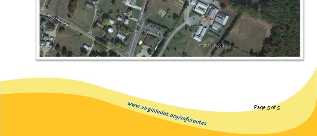
5 Map created with Googe Earth

6 ArrivalandDismissalObservationFieldExerciseGuide,page4 ObservationsontheProcess Date: Time: Location: Whatprocessdidyouobserve? arrival dismissal Brieflydescribetheprocessthatyouobserved: Areallstudentsreleasedatonce? Yes No Ifno,describehowstudentsaredismissed.Whatis theorderandwhatistherationale? Wheredostudentsenter/exittheschool campusandtheschoolbuildingandhowiseach entranceused?(bygrade,bymodeoftravel,etc.) Approximatelyhowmanystudentsdidyou observeusingeachmodeoftravel? Walking Biking Wheredostudentsparktheirbikes? Approximatelyhowmanyvehiclesdidyou observeoncampus? Familyvehicles Howmanybuses? Wheredoparentspickupanddropofftheirchildren?Isthisactivityseparatedfrom walking/bicycling?doesthequeueofcarsbackupintothestreet?
7 Domotoristsyieldtopedestrians? Yes No Notes: Arestudentswalkingwhereitissafe? Yes No Arestudentswalkinginawaythatissafeand alert?i.e.nothorsingaroundorrunningbetween cars? Yes No Notes: Arebicyclistsobservingrulesoftheroad? Arebicyclistswearinghelmets? Yes(count) No(count) Notes: Howarestudentsmatchedwithfamilyvehicles? Oncampusbehavior Domotoristsobserverulesoftheroad? Yes No Dotheyobserveparkingrestrictions? Yes No Notes: Arestudentscrossingwheretheyaresupposed to? Yes No Aretheycrossinginawaythat ssafe? Yes No Notes: Arestudentsbehavingsafelyaroundbuses? Yes No Arebusdriversawareofstudentswalkingon campus? Yes No Notes: Didyouobserveanyunsafebehaviorsamong studentsinfamilyvehicles/parents/drivers? ArrivalandDismissalObservationFieldExerciseGuide,page5
8 ArrivalandDismissalObservationFieldExerciseGuide,page6 SafetyIssuesandConcerns Dostudentsand/orparentsusetheirownarrival ordismissalrulesthatcreateasafetyconcern? Didyouobserveanydesirelinesorgoattrails thatindicatewherepedestrianshavecreated theirownpathways?didyouseeanyoneusing them? Arethereanyvisibleobstructionsthatmakeitdifficultfordriverstoseepedestrians/bicyclistsor viceversa? AdditionalNotes:
July 5, Arthur R. Ware, Jr. Elementary School 2017 Safe Routes to School Walkabout Report
 July 5, 2017 Arthur R. Ware, Jr. Elementary School 2017 Safe Routes to School Walkabout Report 1 Walkabout Report Introduction On April 28, 2017, City, School, and SAWMPO staff met to conduct a Safe Routes
Walkabout Summary Report
 Walkabout Summary Report Introduction On September 3, 2014, stakeholders at Bessie Weller Elementary School (Bessie Weller ES) in Staunton, Virginia met to examine the walking and bicycling network around
SAFE ROUTES TO SCHOOL
 SAFE ROUTES TO SCHOOL Forest Ridge Elementary School Existing Conditions and ACTION PLAN > Oak Creek - Franklin Joint School District Table of Contents CONTEXT Enrollment Boundaries
Arlington Public Schools Thomas Jefferson Site Evaluation Transportation Networks. Thomas Jefferson Working Group Meeting #6 November 10, 2014
 Arlington Public Schools Thomas Jefferson Site Evaluation Transportation Networks Thomas Jefferson Working Group Meeting #6 November 10, 2014 2 3 INTRODUCTION 4 Goal of our work: Identify and assess multi-modal
Sebastopol Charter School Traffic Management Plan
 Sebastopol Charter School The serves as the working document in support of these essential goals: to ensure the safety and efficiency of student arrival to and departure from school to ensure the safety
C/CAG. Sunnybrae Elementary School Walking and Bicycling Audit. San Mateo-Foster City School District JUNE 2013
 Sunnybrae Elementary School Walking and Bicycling Audit JUNE 2013 San Mateo-Foster City School District C/CAG City/County Association of Governments of San Mateo County SUNNYBRAE ELEMENTARY SCHOOL WALKING
Drag and drop pic and stretch/crop to the limits of the blue rectangle (delete this text box) Maxey Elementary School
 Maxey Elementary School") Drag and drop pic and stretch/crop to the limits of the blue rectangle (delete this text box) Maxey Elementary School SCHOOL ROUTE PLAN For MAXEY ELEMENTARY SCHOOL LOCATION 33 ORANGE COUNTY Prepared for:
Drag and drop pic and stretch/crop to the limits of the blue rectangle (delete this text box) Maxey Elementary School SCHOOL ROUTE PLAN For MAXEY ELEMENTARY SCHOOL LOCATION 33 ORANGE COUNTY Prepared for:
Arlington Public Schools New Elementary School at Thomas Jefferson Site Off-Site Transportation. Thomas Jefferson BLPC / PFRC Meeting July 27, 2016
 Arlington Public Schools New Elementary School at Thomas Jefferson Site Off-Site Transportation Thomas Jefferson BLPC / PFRC Meeting July 27, 2016 1.Review of Analysis 2.Key Transportation Issues 3.Recommendations
James Williams Middle School 915 Acacia Lane
 James Williams Middle School 915 Acacia Lane Grades Served: 6 th -8 th Student Geography According to an address analysis of students, 36.7% of students attending JWMS live within 2 miles of school (see
Enhanced Walkabout Summary Report
 Enhanced Walkabout Summary Report Introduction On September 18, 2013, thirteen participants met at Galax Elementary School in Galax, Virginia to examine the walking and bicycling network around the elementary
Agenda. Overview PRINCE GEORGE S PLAZA METRO AREA PEDESTRIAN PLAN
 PRINCE GEORGE S PLAZA METRO AREA PEDESTRIAN PLAN May 28, 2008 Agenda Welcome and introductions Project overview and issue identification Planning context and strengths Design challenges and initial recommendations
Chapter 3.9 Timbercrest Elementary School. Volusia County MPO. November 2008
 Chapter 3.9 Timbercrest Elementary School Deltona, FL Volusia County MPO November 2008 Volusia County MPO School Bicycle and Pedestrian Review Study, Phase 3B School Summary Timbercrest Elementary School
Orange Center Elementary School
 Drag and drop pic and stretch/crop to the limits of the blue rectangle (delete this text box) Orange Center Elementary School Drag and drop pic and stretch/crop to the limits of the blue rectangle (delete
Enhanced Walkabout Summary Report
 Enhanced Walkabout Summary Report Introduction On September 25, 2013, ten participants met at Jackson Via Elementary School in Charlottesville, Virginia to evaluate the walking and bicycling network around
Windy Ridge Elementary School
 Windy Ridge Elementary School SCHOOL ROUTE PLAN For WINDY RIDGE ELEMENTARY SCHOOL LOCATION 54 ORANGE COUNTY Prepared for: ORANGE COUNTY SCHOOL ASSESSMENT PROGRAM ORANGE COUNTY PUBLIC WORKS Traffic Engineering
Hidden Oaks Elementary School
 Hidden Oaks Elementary School SCHOOL ROUTE PLAN For HIDDEN OAKS ELEMENTARY SCHOOL LOCATION 13 ORANGE COUNTY Prepared for: ORANGE COUNTY SCHOOL ASSESSMENT PROGRAM ORANGE COUNTY PUBLIC WORKS Traffic Engineering
MEMORANDUM. Discussion of the planned crosswalk improvement on Mount Vernon Road near Stratham Drive
 MEMORANDUM To: From: Mayor and City Council Michael Smith, Public Works Director Date: August 24, 2015 Subject: Discussion of the Mount Vernon Road Crosswalk Improvement ITEM DESCRIPTION Discussion of
TRAFFIC ACTION PLAN. Laurie Meadows Neighborhood CITY OF SAN MATEO
 TRAFFIC ACTION PLAN Laurie Meadows Neighborhood CITY OF SAN MATEO Draft January 2017 Table of Contents Introduction... 2 The Traffic Forum Process... 5 Neighborhood Traffic Issues... 7 Neighborhood Recommendations
City of Vallejo Traffic Calming Toolbox
 City of Vallejo Traffic Calming Toolbox June 1, 2013 Final Table of Contents Introduction... 1 Non-Physical Devices... 3 High-Visibility Crosswalk... 3 In Pavement Lighted Crosswalk... 4 Rapid Flashing
SAFE ROUTES TO SCHOOL
 SAFE ROUTES TO SCHOOL Edgewood Elementary School Existing Conditions and ACTION PLAN > Oak Creek - Franklin Joint School District Table of Contents CONTEXT Enrollment Boundaries Enrollment
Chapter 3.3 Horizon Elementary School. Volusia County MPO. June 2009
 Chapter 3.3 Horizon Elementary School Port Orange, FL Volusia County MPO June 2009 Volusia County MPO School Bicycle and Pedestrian Review Study, Phase 3C School Summary Horizon Elementary School is located
Lake Whitney Elementary School
 Lake Whitney Elementary School SCHOOL ROUTE PLAN For LAKE WHITNEY ELEMENTARY SCHOOL LOCATION 18 ORANGE COUNTY Prepared for: ORANGE COUNTY SCHOOL ASSESSMENT PROGRAM ORANGE COUNTY PUBLIC WORKS Traffic Engineering
General Design Factors
 Chapter 3: 3-1.0 Introduction General Design Factors Mn/DOT s goals include encouraging and accommodating safe bicycling. From a design perspective, these goals are achieved by first having an understanding
CURBSIDE ACTIVITY DESIGN
 5 CURBSIDE ACTIVITY DESIGN This chapter provides design guidance for separated bike lanes adjacent to curbside activities including parking, loading and bus stops. Typical configurations are presented
Appendix A: Crosswalk Policy
 Appendix A: Crosswalk Policy Appendix A: Crosswalk Policy Introduction This citywide Crosswalk Policy is aimed at improving pedestrian safety and enhancing pedestrian mobility by providing a framework
TRAFFIC ACTION PLAN. North Central Neighborhood CITY OF SAN MATEO
 TRAFFIC ACTION PLAN North Central Neighborhood CITY OF SAN MATEO Draft February 2017 Table of Contents Introduction... 1 The Traffic Forum Process... 4 Neighborhood Traffic Issues... 6 Neighborhood Recommendations
Lawrence Safe Routes to School. Community Meeting January 14, 2015
 Lawrence Safe Routes to School Community Meeting January 14, 2015 Safe Routes to School The 6 E s Education Encouragement Enforcement Engineering Evaluation Equity What are the elements of a SRTS plan?
Meadow Woods Elementary School
 Drag and drop pic and stretch/crop to the limits of the blue rectangle (delete this text box) Meadow Woods Elementary School Drag and drop pic and stretch/crop to the limits of the blue rectangle (delete
Multi-Modal Traffic Analysis. Parisi and Associates
 Mill Valley to Corte Madera Bicycle and Pedestrian Corridor Study Appendix D: Multi-Modal Traffic Analysis Prepared by Parisi and Associates August 2009 Appendix D - Multi-Modal Traffic Analysis Table
Guidance. ATTACHMENT F: Draft Additional Pages for Bicycle Facility Design Toolkit Separated Bike Lanes: Two-Way to One-Way Transitions
 ATTACHMENT F: Draft Additional Pages for Bicycle Facility Design Toolkit Separated Bike Lanes: Two-Way to One-Way Transitions This treatment provides a transition from two-way separated bike lanes to one-way
Pearl Sample Elementary & A.G. Richardson Elementary Walkabout Report
 Pearl Sample Elementary & A.G. Richardson Elementary Walkabout Report Introduction On December 14, 2017, stakeholders at Pearl Sample Elementary School and A.G. Richardson Elementary School in Culpeper,
Route 29 Solutions Projects
 Route 29 Solutions Route 29 Solutions Projects www.route29solutions.org October 10, 2014 Route 29 Widening to Six Lanes Albemarle County This project will widen a 1.8-mile segment of Route 29 from four
2 Mark Twain Elementary School Report
 2 Mark Twain Elementary School Report Principal: Greg Kaatz Grades: K-2 Enrollment: 323 Address: 425 N. Church Street First bell: 8:10 a.m. Silverton, OR 97381 Last bell: 2:30 p.m. Free & Reduced Lunch:
5. RUNNINGWAY GUIDELINES
 5. RUNNINGWAY GUIDELINES These guidelines should be considered collectively when making runningway decisions. A runningway is the linear component of the transit system that forms the right-of-way reserved
Lynchburg District Update
 Lynchburg District Update Virginia Statewide Bicycle and Pedestrian Advisory Committee Spring Meeting May 16 th, 2017 David Cook Transportation Planner, VDOT Lynchburg District Table of Contents Active
PRINCE GEORGE S PLAZA METRO AREA PEDESTRIAN PLAN
 PRINCE GEORGE S PLAZA METRO AREA PEDESTRIAN PLAN May 28, 2008 Agenda Welcome and introductions Project overview and issue identification Planning context and strengths Design challenges and initial recommendations
CHAPTER 1 STANDARD PRACTICES
 CHAPTER 1 STANDARD PRACTICES OBJECTIVES 1) Functions and Limitations 2) Standardization of Application 3) Materials 4) Colors 5) Widths and Patterns of Longitudinal Pavement Marking Lines 6) General Principles
Cycle Track Design Best Practices Cycle Track Sections
 Design Best Practices Sections It is along street segments where the separation and protection methods of cycle tracks offer more comfort than conventional bicycle lanes, and are more attractive to a wide
Traffic Circulation & Pedestrian Safety Study
 Lyons Township High School North Campus La Grange, Illinois Parking Lot Vaughan Building N Main Building Prepared for: Prepared by: July 23, 2015 Contents List of Figures, iii 1. Introduction...1 2. Existing
Improvements Infrastructure Gap Assessment and Improvements Street Striping
 Infrastructure Project Proposal The federal-aid Safe Routes to School program funds infrastructure/engineering projects that fall into two categories: Design (available only to School Development Authority
Completing the Street: Denning Drive
 Completing the Street: Denning Drive Public Workshop and Walking Audit Winter Park Civic Center May 12, 2016 Completing the Street What Makes This a Complete Street? Completing the Street Complete Streets
and older adults and people with disabilities still face barriers when using the pedestrian network and public transportation.
 Background Afterthe1980Olympics,theLakePlacid/NorthElbacommunityadoptedaneconomicstrategy ofdevelopingandmarketingeventstoincreaseareatourism.thisstrategyhasbeenvery successful.overrecentyearsthevolumeofvisitorshasincreased,andthelengthofthe
Chicago Safe Routes to School Safe Routes to High School (SRTS/SRTHS)
") Chicago Safe Routes to School Safe Routes to High School (SRTS/SRTHS) Marshall Community High School and Faraday Elementary School Recommended Improvements Agenda Goals Related Programs Project Location/Area
Chicago Safe Routes to School Safe Routes to High School (SRTS/SRTHS) Marshall Community High School and Faraday Elementary School Recommended Improvements Agenda Goals Related Programs Project Location/Area
Appendix T CCMP TRAIL TRAFFIC & TRANSPORTATION DESIGN STANDARD
 Appendix T CCMP 3.3.4 TRAIL TRAFFIC & TRANSPORTATION DESIGN STANDARD 3.3.4 Trail Traffic and Transportation Design Multi-use trails have certain design standards, which vary depending on the agency that
Durrance Elementary School
 Durrance Elementary School SCHOOL ROUTE PLAN For DURRANCE ELEMENTARY SCHOOL LOCATION 9 ORANGE COUNTY Prepared for: ORANGE COUNTY SCHOOL ASSESSMENT PROGRAM ORANGE COUNTY PUBLIC WORKS Traffic Engineering
NJDOT Complete Streets Checklist
 Background The New Jersey Department of Transportation s Complete Streets Policy promotes a comprehensive, integrated, connected multi-modal network by providing connections to bicycling and walking trip
CHILLICOTHE CITY SCHOOLS. SAFE ROUTES TO SCHOOL TRAVEL PLANS for Allen, Mt. Logan, Tiffin & Worthington Elementary Schools January 2013
 CHILLICOTHE CITY SCHOOLS SAFE ROUTES TO SCHOOL TRAVEL PLANS for Allen, Mt. Logan, Tiffin & Worthington Elementary Schools January 2013 i Ohio s Safe Routes to School Travel Plan Template www.dot.state.oh.us/saferoutes
TRAFFIC MANAGEMENT PLAN
 292 84 140440 TRAFFIC MANAGEMENT PLAN The purpose of the Traffic Management Plan (TMP) is to have established procedures for traffic flow and circulation around the elementary school related to student
PERFORMANCE ACTIVITY 405 LIMB MANAGEMENT
 PERFORMANCE ACTIVITY 405 LIMB MANAGEMENT 405 LIMB MANAGEMENT ACTIVITY DESCRIPTION Cut and/or remove and/or grind tree limbs from the right-of-way. TRAFFIC CONTROL Utilize intermittent mobile operations
Getting Your SRTS Project Funded. Ryan Snyder
 Getting Your SRTS Project Funded Ryan Snyder Steps in Submitting a Successful Application 1. Stakeholder outreach: create a SRTS coalition 2. Develop a comprehensive plan and program with all 5 Es 3. Conceive
Dec 2, Dear Tri Ong, Sam Woods, and Scott Kubly,
 Dec 2, 2014 Dear Tri Ong, Sam Woods, and Scott Kubly, Thank you for providing us with the 2015 Arterial Asphalt and Concrete (AAC) repaving project 60% plan for Roosevelt Way NE. It's exciting to see the
This Chapter sets forth the minimum design, technical criteria and specifications to be used in the preparation of all roadway plans.
 4.1 GENERAL This Chapter sets forth the minimum design, technical criteria and specifications to be used in the preparation of all roadway plans. These Roadway Standards are for new construction and modification
NEIGHBORHOOD TRAFFIC CALMING POLICY
 NEIGHBORHOOD TRAFFIC CALMING POLICY I. PURPOSE The City of Kent continually strives to strengthen and protect its neighborhoods by improving the quality of life in residential areas. Traffic conditions
Off-road Trails. Guidance
 Off-road Trails Off-road trails are shared use paths located on an independent alignment that provide two-way travel for people walking, bicycling, and other non-motorized users. Trails specifically along
Bicycle and Pedestrian Facilities Toolbox (Excerpt from Figure 3.1)
") Appendix B Neighborhood Connections Summaries This Appendix is a supplement to the information presented in Chapter 3 Connect People. The Appendix includes a summary or profile for each of the proposed
Appendix B Neighborhood Connections Summaries This Appendix is a supplement to the information presented in Chapter 3 Connect People. The Appendix includes a summary or profile for each of the proposed
Arlington Public Schools Abingdon Elementary School Site Evaluation Preliminary Transportation Findings
 Arlington Public Schools Abingdon Elementary School Site Evaluation Preliminary Transportation Findings Arlington County Public Facilities Review Committee (PFRC) November 19, 2014 SAN ANTONIO-BEXAR COUNTY
Elkton Elementary School Walkabout Report
 Elkton Elementary School Walkabout Report Introduction On September 12, 2017, stakeholders at Elkton Elementary School in Elkton, Virginia met to examine the walking and bicycling networks around the school
section 4 Existing Conditions, Issues, and Options
 section 4 Existing Conditions, Issues, and Options 4.0 Existing Conditions, Issues, and Options This section analyzes each segment of the corridor on a street to street basis. Each segment is discussed
Safe Routes to School Comprehensive Plan
 Safe Routes to School Comprehensive Plan City of Rosemount Dakota County, MN June 2010 Prepared by: Project Background The Statewide Health Improvement Program (SHIP) aims to help Minnesotans live longer,
Safe Routes to School Comprehensive Plan
 Safe Routes to School Comprehensive Plan City of Apple Valley Dakota County, MN May 2010 Prepared by: Project Background The Statewide Health Improvement Program (SHIP) aims to help Minnesotans live longer,
ALLEY 24 TRAFFIC STUDY
 ALLEY 24 TRAFFIC STUDY in City of Frostburg, Maryland January 2013 3566 Teays Valley Road Hurricane, WV Office: (304) 397-5508 www.denniscorporation.com Alley 24 Traffic Study January 2013 Frostburg, Maryland
Settles Bridge Elementary School Safe Routes to School Travel Plan
 Settles Bridge Elementary School Safe Routes to School Travel Plan 600 James Burgess Road Suwanee, GA 30024 February 2012 PAGE 1 BETHUNE ELEMENTARY SCHOOL TRAVEL PLAN Table of Contents Table of Contents...
Speed Control & Limits
 Speed Control & Limits Exceeding the speed limit is a common contributing factor of fatal and other types of accidents. *25 mph* School zones, business or residential districts *55 mph* Certain state highways
Implementing the Three Es of School Zone Traffic Calming
 Implementing the Three Es of School Zone Traffic Calming Use this evaluation tool as a guide to analyze the specific safety needs of your school. SCHOOL PROFILE School Name: School District: Address: Phone
Copenhagen Cycling Map. Red Lines Cycling facilities
 Copenhagen Cycling Map Red Lines Cycling facilities Copenhagen Cycling Facilities Design Approaches Transportation without Pollution Copenhagen s Strategy Where Cycling is one of the top key activities
Houma-Thibodaux Metropolitan Planning Organization STP<200K Funding Application APPLICATION
 APPLICATION HOUMA-THIBODAUX METROPOLITAN PLANNING ORGANIZATION (HTMPO) FOR SURFACE TRANSPORTATION PROGRAM (STP
Chapter 4 Traffic Analysis
 Chapter 4 Traffic Analysis PURPOSE The traffic analysis component of the K-68 Corridor Management Plan incorporates information on the existing transportation network, such as traffic volumes and intersection
HALFF TRAFFIC MANAGEMENT PLAN. Richardson ISD Northwood Hills Elementary School Dallas, Texas. /? /4O/2o16
 30279 161966 TRAFFIC MANAGEMENT PLAN Richardson ISD Northwood Hills Elementary School August 30 2016 Exhibit 976B Planned Development District No. 976 Z156-311(OTH) Approved City Plan Commission October
AGENDA REPORT. Issue: Discussion of potential improvements on Barnwell Road at Niblick Drive
 AGENDA REPORT To: From: By: Honorable Mayor and City Council Members Warren Hutmacher, City Manager Tom Black, Public Works Director Date: March 23, 2016 Agenda: March 28, 2016 WORK SESSION AGENDA: Barnwell
Vallecito Elementary School. Travel Plan
 Vallecito Elementary School Travel Plan TABLE OF CONTENTS 1. PURPOSE... 1 1.1. SR2S PLANNING, IMPLEMENTATION AND MONITORING... 1 1.2. MARIN COUNTY MEASURE A... 1 2. VALLECITO ELEMENTARY SCHOOL PROFILE...
Item to be Addressed Checklist Consideration YES NO N/A Required Description Complete Streets Guidelines
 Passaic County Complete Streets Checklist - Concept Development Project Name Item to be Addressed Checklist Consideration YES NO N/A Required Description Complete Streets Guidelines Existing Plans Have
North Buckhead Civic Association. Recommendations For Wieuca Road
 North Buckhead Civic Association Recommendations For Wieuca Road October 7, 2009 Blank Page Page 2 of 16 Table of Contents 1. BACKGROUND 4 2. TRAFFIC SIGNALS AND ALL WAY STOPS 5 3. SPEED LIMITS AND SPEED
CITY OF OAK CREEK SAFE ROUTES TO SCHOOL ACTION PLAN. East Middle School
 CITY OF OAK CREEK SAFE ROUTES TO SCHOOL ACTION PLAN East Middle School CITY OF OAK CREEK SAFE ROUTES TO SCHOOL ACTION PLAN East Middle School Why Safe Routes to School? Safe Routes to School ( SRTS ) is
CITY OF WEST LAKE HILLS. Forest View Neighborhood Traffic Calming Study
 CITY OF WEST LAKE HILLS 901 South Mopac Expressway Building V, Suite 220 Austin, Texas 78746 Texas P.E. Firm Registration No. F-929 Klotz Associates Final Report Submittal: March 20, 2015 Revised Final
Chapter 2: Standards for Access, Non-Motorized, and Transit
 Standards for Access, Non-Motorized, and Transit Chapter 2: Standards for Access, Non-Motorized, and Transit The Washtenaw County Access Management Plan was developed based on the analysis of existing
3 Silverton High School Report
 3 Silverton High School Report Principal: Justin Lieuallen Grades: 9-12 Enrollment: 1,277 Address: 1456 Pine Street First bell: 7:55 a.m. Silverton, OR 97381 Last bell: 3:05 p.m. Free & Reduced Lunch:
Basic Rules of Pedestrian Safety (Primary, Elementary)
") Basic Rules of Pedestrian Safety (Primary, Elementary) Grouping Individual Pair Small Group Whole Class Purpose To provide students with the basic knowledge and skill practice necessary to be safe pedestrians
Basic Rules of Pedestrian Safety (Primary, Elementary) Grouping Individual Pair Small Group Whole Class Purpose To provide students with the basic knowledge and skill practice necessary to be safe pedestrians
Lesson #7. Review: Lesson #6 Destination: Eureka. SKILLS A. Protected Left Turns
 SKILLS A. Protected Left Turns Lesson #7 Review: Lesson #6 Destination: Eureka 1. The only time you are protected from oncoming traffic is when you have a green left turn arrow 2. Oncoming traffic has
SCHOOL ROUTE PLAN. For HUNTER S CREEK ELEMENTARY SCHOOL LOCATION 14 ORANGE COUNTY. Prepared for:
 SCHOOL ROUTE PLAN For HUNTER S CREEK ELEMENTARY SCHOOL LOCATION 14 ORANGE COUNTY Prepared for: ORANGE COUNTY SCHOOL ASSESSMENT PROGRAM ORANGE COUNTY PUBLIC WORKS Traffic Engineering Division 42 South John
City of Albert Lea Policy and Procedure Manual 4.10 ALBERT LEA CROSSWALK POLICY
 4.10 ALBERT LEA CROSSWALK POLICY PURPOSE: Pedestrian crosswalks are an integral part of our transportation infrastructure. To be effective and promote safety, marked crosswalks must be installed after
Duwamish Way-finding and CTR Report
 V. North Tukwila When the North Tukwila Manufacturing and Industrial Center was designated in 1992 as part of the region s land use and transportation plan, the plan called for the area to set a light-rail
Safe Routes to School: Valverde Elementary Walk Audit Report. Image: CPLIVE, SkyscraperPage.com
 Safe Routes to School: Valverde Elementary Walk Audit Report Image: CPLIVE, SkyscraperPage.com April 28, 2016 1 OVERVIEW As part of the 2014/2015 Denver Safe Routes to School (SRTS) Program, WalkDenver
Roadway Classification Design Standards and Policies. Pueblo, Colorado November, 2004
 Roadway Classification Design Standards and Policies Pueblo, Colorado November, 2004 Table of Contents Page Chapter 1. General Provisions 1.1 Jurisdiction 3 1.2 Purpose and Intent 3 1.3 Modification 3
Broad Street Bicycle Boulevard Design Guidelines
 Broad Street Bicycle Boulevard Design Guidelines Building from the strategies introduced in the 2013 Bicycle Transportation Plan and community input received thus far, City Transportation Staff have identified
CHAPTER 16 PEDESTRIAN FACILITIES DESIGN AND TECHNICAL CRITERIA TABLE OF CONTENTS
 CHAPTER 16 PEDESTRIAN FACILITIES DESIGN AND TECHNICAL CRITERIA TABLE OF CONTENTS Section Title Page 16.1 General... 16-1 16.1.1 AASHTO Reference... 16-1 16.1.2 ADA Requirements... 16-1 16.2 Sidewalks...
Rim Rock Elementary School Walking and Biking Audit
 Rim Rock Elementary School Walking and Biking Audit September 29, 2016 Rim Rock Elementary School Audit for Walking and Biking September 29, 2016 Audit Team Members: Sam Atkins, City Engineer, City of
MEMORANDUM INTRODUCTION AREA DESCRIPTION. DATE: December 8, 2017
 7719 SOUTH MAIN STREET MIDVALE, UT 84047 P 801.307.3400 MEMORANDUM DATE: December 8, 2017 TO: FROM: SUBJECT: PROJECT NUMBER: 344-7517-003 PROJECT NAME: Keith Ludwig, P.E. Midvale City Lesley Burns, Midvale
Ballston Station Multimodal Study WMATA and Arlington County. Meeting Minutes
 Date of Meeting: June 10, 2010 Location: Ballston Metrorail Station and NRECA Building 4301 Wilson Blvd, Arlington, VA Subject: Ballston Station Multimodal Study Stakeholder Meeting #1 Summary: This first
Table of Contents. I. Introduction 1. II. Elements of the School Crossing Program 1
 Table of Contents Page I. Introduction 1 II. Elements of the School Crossing Program 1 a. Identifying Locations Where School Crossing Guards are Needed 1 b. The Role of the School Crossing Guard 1 c. Hiring
Eliminate on-street parking where it will allow for a dedicated bus only lane %
 Traffic Dashboard Priorities Survey Responses Introduction 1) Are you familiar with bus rapid transit (BRT)? a. No, BRT is new to me. 597 23.5% b. I ve heard of BRT, but I don t know much about it. 1,136
City of Davis East Covell Corridor Plan
 Community Open House #2 January 22, 2014 6:00 8:00 p.m. Veterans Memorial Center, Club Room City of Davis Introduction The (ECCP) is a taking a comprehensive look at the existing transportation systems
COWETA HIGH SCHOOL AND EAST HIGHWAY 51
 COWETA HIGH SCHOOL AND EAST HIGHWAY 51 Lack of sidewalks along Ben Lumpkin Rd. Lack of crosswalks and ramps at intersection. Hwy 51 is wide to cross as a pedestrian. No ADA compliance or connection to
BICYCLE AND PEDESTRIAN SCHOOL SAFETY REVIEW STUDY BUDDY TAYLOR MIDDLE SCHOOL PALM COAST, FLAGLER COUNTY, FL
 BICYCLE AND PEDESTRIAN SCHOOL SAFETY REVIEW STUDY BUDDY TAYLOR MIDDLE SCHOOL PALM COAST, FLAGLER COUNTY, FL Assessment & Implementation Report June 2017 Bicycle and Pedestrian Safety Review This page is
S A F E R O U T E S T O S C H O O L H E R M A N TOW N S C H O O L S A N D P R O C TO R S C H O O L S P L A N A P P R OVA L S
 S A F E R O U T E S T O S C H O O L H E R M A N TOW N S C H O O L S A N D P R O C TO R S C H O O L S P L A N A P P R OVA L S WHAT IS SAFE ROUTES TO SCHOOL? In 1969, nearly 50% of children walked or rode
King Soopers #116 Thornton, Colorado
 Traffic Impact Study King Soopers #116 Thornton, Colorado Prepared for: Galloway & Company, Inc. 1.0 EXECUTIVE SUMMARY King Soopers #116, a grocery marketplace anchored commercial development, is proposed
St. Francis Drive through the City of Santa Fe Corridor Study
 VII. ENGINEERING AND ENVIRONMENTAL EVALUATION TRAIL CONNECTIVITY In the southern portion of the Corridor there is a lack of a sidewalk, trail or bicycle facility within the right-ofway. However, the City
Built Environment Childhood Obesity Forum September 15, 2010
 Built Environment Childhood Obesity Forum September 15, 2010 TITLE Why do we have cities? Boston MA To minimize travel & maximize exchange (bring people closer together) How have we built our urban roadway
TRAFFIC ACTION PLAN. North Shoreview Neighborhood CITY OF SAN MATEO
 TRAFFIC ACTION PLAN North Shoreview Neighborhood CITY OF SAN MATEO Draft February 2017 Table of Contents Introduction... 1 The Traffic Forum Process... 4 Neighborhood Traffic Issues... 6 Neighborhood Recommendations
Chapter 4.3 Enterprise Elementary. Volusia County MPO. March Page 7.0
 Chapter 4.3 Enterprise Elementary Enterprise, FL Volusia County MPO March 2008 Page 7.0 Volusia County MPO Bicycle and Pedestrian School Safety Review Study Introduction Enterprise Elementary School is
MEMORANDUM. Charlotte Fleetwood, Transportation Planner
 MEMORANDUM Date: Updated August 22, 2017 To: Organization: Charlotte Fleetwood, Transportation Planner Boston Transportation Department From: Jason DeGray, P.E., PTOE, Regional Director of Engineering