Thirsk Castle. To begin the walk go to the west of
|
|
|
- Hugh Weaver
- 5 years ago
- Views:
Transcription
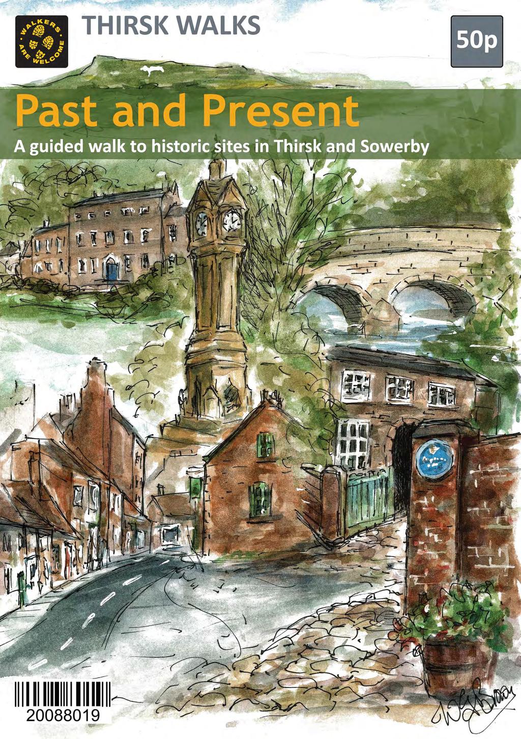
1


2 Past and Present is a walk around Thirsk and Sowerby to enjoy the town and countryside, but also to learn about local history. It takes in sites of historical and environmental approximately three miles long, but it may be shortened. from the centre of Thirsk. They include the site of Thirsk Castle and a prehistoric burial mound. Along the route are Blue Plaques about buildings and people of The walk Thirsk Castle To begin the walk go to the west of and enter Castlegate. Take the alley on the right beside Lee s butchers which leads to the grassy area of Castle Garth, the site where Thirsk Castle once stood and where you will boards 1, 2 & 3. Go down the slope and turn right, taking the footpath that leads northwards to join Pick s Lane, named opposite the kissing gate. The farm has been redeveloped and houses built on the site. From board 13:


3 Kirkgate For the main route turn right and go down Pick s Lane to enter Kirkgate. Rhodes Brewery, now converted into existed in the street. Thirsk Museum is to the right. Thomas Lord, famous for founding Lord s Cricket Ground in London, was born there. Both routes lead into Kirkgate. At the northern end of the street is the Parish Church built in the Perpendicular style and dedicated to Saint Mary. Other buildings of interest are the World of James Herriot where vet and author, had his surgery and Thirsk Hall, the home of the Lords of the Manor. Walk towards the church and cross the road. The Holmes runs parallel to the main road and is board 4 Board 5 is nearby, located on the Holmes. Retrace your steps to the eastern end of the church and walk board 6 which is near the Moated Site. From board 15:
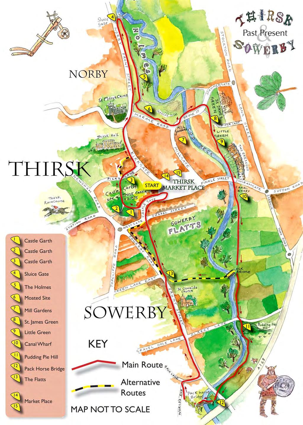
4


5 Millgate reach Millgate. Cross the road and board 7 and site of the former mill. Old Thirsk Cross the bridge to enter Bridge Street. This leads to Saint James on the right. These areas are the original site of the town and you will boards 8 & 9 here. along the path that leads beside the river. Note the Victorian houses of road and follow the footpath through the garage premises to board 10 sited near Canal Wharf. Follow the grass footpath beside the that part of the river was straightened opposite side of the river which show evidence of the ridge and furrow method of ploughing. At Lock Bridge there is a choice of routes. From board 6:

6 southwards along the path. This follows the river and may be rather Bronze age burial mound Cross the road at Blakey Bridge and make the short detour to board 11 at Pudding Pie Hill. This is an ancient old, which is clearly visible from the bridge. From board 12: World s End Return to the main path which crosses pasture land and terminates near World s End Bridge. Cross the road for the Pack Horse Bridge and board 12. Walk over the bridge and take the right hand path which follows a green lane to join Back Lane. The house on the right was once the notable World s End public house. Sowerby Turn right and go down the gentle slope to join Front Street, the main up the street. Hole Lane and the large houses on either side of the street built by the prosperous business people of the town. Also note the three Regency houses on the right with steps up to the entrance over the basement. Just before the church on the right is an ancient house called Manor Farm. A building has been on this site since Detour to see St Oswald s Church, Norman door on the south side. board 13 which is on the right near routes from here.

7 Westgate For the main route, follow the further along, situated in the former Courthouse, the Rural Arts Centre. Castlegate, walk the length of the Here boards 14 & 15 are located near Town End has everything you want to know about Thirsk: a group of over 30 volunteers Centre in the middle of Thirsk Market Place. Front cover by Wendy Gibson-Brown
Walk 2: Beamsley Beacon and Bolton Abbey
 Walk 2: Beamsley Beacon and Bolton Abbey Start and Finish: The Memorial Hall, Main Street, Addingham, LS29 0LZ, SE 079 497 The shortest walk is about 5½ miles (8.8km) The medium Walk is about 8¼ miles
Approximate distance: 10 miles For this walk we ve included OS grid references should you wish to use them. Start. End
 Approximate distance: 10 miles For this walk we ve included OS grid references should you wish to use them. 2 3 Start End 1 N W E S Reproduced by permission of Ordnance Survey on behalf of HMSO. Crown
Fertile farms in the heart of Kent
 55 55 Fertile farms in the heart of Kent A bright sunny day is perfect for enjoying the rich and fertile Kent countryside and outstanding views across the valley of the Great Stour to the North Downs.
Walk 2 Village Hall - The Shippy - Woodhouse Farm - Village Hall
 Walk 2 Village Hall - The Shippy - Woodhouse Farm - Village Hall The walk is approximately 4km (2.5 miles) across fairly flat countryside with about a quarter on country lanes. It should take about 1 hour
The Hundred Parishes
 The Hundred Parishes Walks from railway stations number 9 6.4 miles (10kms) from Bishop s Stortford to Stansted Mountfitchet Start: Bishop s Stortford station (Grid Reference TL492209) (ample parking and
Slindon Folly - South Downs, West Sussex
 Slindon Folly - South Downs, West Sussex Starts at Park road-side near entrance to Slindon College 2 hours 15 minutes 4.5miles 7.2km Easy ID: 0.1598 Developed by: Chris Mumford Checked by: Rockpit www.ramblersroutes.org
How to get there. Respect - Protect - Enjoy
 How to get there Driving: Postcode is RG9 3DG and there is a carpark just across from the pub. Nearest station: Henley-on-Thames station is 5.6 miles away. We re delighted to present three circular walks
Harlington - Sharpenhoe - Pulloxhill
 Harlington - Sharpenhoe - Pulloxhill ID: 3676, Distance: 8 miles, Height gain: 140 Metres, Map: Explorer 193 Luton & Stevenage, Contributor: Dennis Jeanes Duration: 3 Hours 27 Mins Features Church,Great
NEWLANDS CORNER AND ST MARTHAS
 NEWLANDS CORNER AND ST MARTHAS 10k CIRCULAR ROUTE 2½-3HRS GU4 8SE From Newlands Corner on the North Downs just outside Guildford, you can enjoy one of the most beautiful panoramas of quintessential English
Husthwaite to Byland Abbey
 Husthwaite to Byland Abbey This walk begins with a loop round the village of Husthwaite and continues towards Coxwold along a disused railway line, which is now a right of way. It passes through Coxwold
9.5 km Circular 3 hours
 MEDIEVAL WAVERLEY Challenging Terrain A 6 mile (9.5km) undulating circular walk from Tilford village passing close to The Sands village and the historic ruins of Waverley Abbey. From the top of Crooksbury
There are toilets at Manningtree Station, Flatford (close to the hump back bridge) and in Dedham.
 and in Dedham.") Arriving by Train Main Features of the Walk Outline Route Employs particularly attractive paths, many of which offer impressive views across Dedham Vale. Includes a section along the tidal section of the
Arriving by Train Main Features of the Walk Outline Route Employs particularly attractive paths, many of which offer impressive views across Dedham Vale. Includes a section along the tidal section of the
Launton to Bicester nature footpath improved
 Launton to Bicester nature footpath improved Published 13 July 2012 An attractive rural footpath linking Launton to Bicester has brought back into use by the council's Countryside team. Staff have improved
Lincolnshire Walks. Ancaster. Three cir cular walks of2 3/4,4or 6km (11/3, 21/2 or 33/4 miles)
") Lincolnshire Walks Ancaster Three cir cular walks of2 3/4,4or 6km (11/3, 21/2 or 33/4 miles) Introduction These walks are set in the attractive countryside around the historic town of Ancaster. The town
Lincolnshire Walks Ancaster Three cir cular walks of2 3/4,4or 6km (11/3, 21/2 or 33/4 miles) Introduction These walks are set in the attractive countryside around the historic town of Ancaster. The town
Thornton le Dale Walks
 Thornton le Dale Walks A collection of circular walks in, and around, the village www.visitthorntonledale.co.uk Thornton-le-Dale Traders Forum and Thornton le Dale Parish Council 1 Thornton le Dale Circular
Danbury Words and pictures by Laurie Page of the Public Rights of Way team at Essex County Council.
 Danbury Words and pictures by Laurie Page of the Public Rights of Way team at Essex County Council. An undulating walk from Danbury village to the bluebells at the National Trust property of Blakes Wood.
Saltash, Cornwall - Railways, Rivers & Castles
 Saltash, Cornwall - Railways, Rivers & Castles Starts at St Stephen's Church, Saltash, Cornwall 2 hours 45 minutes 5.5miles 8.9km Easy ID: 0.2532 Developed by: Peter Clements Checked by: Kevin Connor www.ramblersroutes.org
NETTLESTEAD & YALDING
 NETTLESTEAD & YALDING ULL CIRCUIT - Sheet 1 (first and last sections) Open fields (see 'Introductory Notes') 88 Direction label (as in the walk notes) ROADS: 81 10m Significant roads Redhill arm North
The Mendip Way. Route Directions and Maps Wells to Frome
 The Mendip Way Route Directions and Maps Wells to Frome Website: www.mendiphillsaonb.org.uk Email: mendip@mendiphillsaonb.org.uk Facebook & Twitter: @MendipHillsAONB Phone: 01761462338 1 Wells to Shepton
A Walk around Holmes Chapel starting & finishing at Holmes Chapel Railway Station. by Tony & Lindsay Wright (2016)
") A Walk around Holmes Chapel starting & finishing at Holmes Chapel Railway Station. by Tony & Lindsay Wright (2016) Introduction Holmes Chapel Railway Station is on the Crewe to Manchester line. The station
A Walk around Holmes Chapel starting & finishing at Holmes Chapel Railway Station. by Tony & Lindsay Wright (2016) Introduction Holmes Chapel Railway Station is on the Crewe to Manchester line. The station
The North Pennines from near Langwathby
 3.6 Langwathby to Armathwaite Map panel?? Distance 12.7 miles (20.5 km) Terrain farm, woodland and riverside paths; some potentially muddy tracks; a few short sections of road Grade gently undulating Food
Walk 7: Watchet to washford
 Walk 7: Watchet to washford Length: Moderate - 7.5 miles / 12 km Good For: Theme: History Duration: 2-3 hours depending on speed of walking Notes: This is a moderate to difficult walk in places, with steps,
Clyde Walkway Community Links: Nemphlar Moor Road to Braidwood
 Clyde Walkway Community Links: Nemphlar Moor Road to Braidwood Nemphlar Moor Road to Braidwood Digital Trail Difficulty (out of 3) 2 Distance Main route to Braidwood (shortest) 2.5km, 5km return. Detours
No. 1 By River Ribble & Brungerley Park 3¼ Miles,
 RVRNEWS 102 No. 1 By River Ribble & Brungerley Park 3¼ Miles, Approx 2 Hours This walk starts at the gate on platform 2 of Clitheroe station. Leaving the station turn left making towards Kirkmoor Rd and
CASTLETON and HOPE. Medieval Historical Landscape a self-guided trail
 CASTLETON and HOPE Medieval Historical Landscape a self-guided trail Explore Castleton and Hope s medieval and later past with this self-guided trail. You will discover the history behind the landscape
LDWA SOUTH DOWNS MARATHON
 AHD ahead SDW South Downs Way BL/BR bear left/bear right TL/TR turn left/turn right SP signpost/fingerpost X cross LEG 1 - EAST DEAN to WP1 NORTON GR 470019. Open 1030 to 1300. 9.6 miles. 1.1 From village
LOCAL CIRCUIT EM1: EAST MALLING & BARMING HEATH. N 2m ROADS: Significant roads PATHS: Starting direction Barming Longsole Mission Church
 Ditton Church Scott Close LOCAL CIRCUIT EM1: EAST MALLING & BARMING HEATH 6 Community Centre F Open fields (see 'Introductory Notes') 1m 88 Direction label (as in the walk notes) East Malling Church -
Horsted Keynes to Sheffield Park Hop On The Bluebell Line
 point your feet on a new path to Sheffield Park Hop On The Bluebell Line Distance 11½ km=7 miles Region: West Sussex, East Sussex Author: Hautboy easy walking with a steam train ride Refreshments: The
H&T. H O L L O W E L L & T E E T O N P A R I S H C O U N C I L
 H&T. H O L L O W E L L & T E E T O N P A R I S H C O U N C I L Web site: http://www.hollowellandteeton.org.uk/ Email: pc-clerk@hollowellandteeton.org.uk Re: Hollowell & Teeton Parish Council Mowing Areas
RILLINGTON TO MALTON by Tania Dickinson
 RILLINGTON TO MALTON by Tania Dickinson This walk takes you from the Vale of Pickering up on to the Wold scarp, before dropping down again through the pretty village of Settrington and joining the Centenary
LDWA SOUTH DOWNS MARATHON 13 th MAY 2018
 AHD ahead SDW South Downs Way BL/BR bear left/bear right TL/TR turn left/turn right X cross LEG 1 - EAST DEAN to WP1 NORTON GR 470019. Open 1030 to 1300. 9.7 miles. 1.1 From village hall TL and walk to
Banstead: Village and Woods
 point your feet on a new path : Village and s Distance: 10 km=6 miles Region: Surrey Author: Fusszweig Refreshments:, The Ramblers Rest easy walking Date written: 2-apr-2014 Last update: 11-apr-2017 Map:
Great Bentley Parish Level Crossing Closure Proposal E45 Great Bentley Station
 Great Bentley Parish Level Crossing Closure Proposal E45 Great Bentley Station 1. This crossing is convenient to the residents of the hamlet of Aingers Green (to the south) where the footpath starts (or
CHILTERN RAMBLING TRAIL
 CHILTERN RAMBLING TRAIL This route, including a section of the Ridgeway Long Distance Path, offers breathtaking views from the Chiltern ridge. It starts in the Ashridge Estate and returns to Tring via
Approximate distance: 5.5 miles For this walk we ve included OS grid references should you wish to use them. Start. End
 Approximate distance: 5.5 miles For this walk we ve included OS grid references should you wish to use them. End 4 1 Start 3 2 N W E S Reproduced by permission of Ordnance Survey on behalf of HMSO. Crown
Hit The Road 2018 Frog and Toad
 Hit The Road 2018 Frog and Toad Meet at Mile End Park. See joining instructions for more details. Sign in so that we know you are there. Chat with friends who you haven t seen since last year and OFF WE
CHINTHURST HILL AND THE GRANTLEY ARMS, SURREY
 CHINTHURST HILL AND THE GRANTLEY ARMS, SURREY 4 miles Circular 2 hours 110417 Challenging Terrain A 4 mile (can be shortened to 3 miles) circular pub walk near Wonersh in Surrey. The walk begins with an
Countryside Walks. 1) Highclere Park Public Walk.
 Highclere Park Public Walk.") 1) Highclere Park Public Walk. Access: From Highclere Estate Main Entrance at Whitway, please note there is no parking on site or access for vehicles. Open: Throughout the year. Description: This footpath
1) Highclere Park Public Walk. Access: From Highclere Estate Main Entrance at Whitway, please note there is no parking on site or access for vehicles. Open: Throughout the year. Description: This footpath
Redesdale Arms. A Trio of Walks
 Redesdale Arms A Trio of Walks Welcome to The Redesdale Arms Hotel The award winning 34 bedroom Redesdale Arms Hotel sits at the gateway to the Cotswolds in the High Street of the historic town of Moreton-in-Marsh.
For more information and to buy this book click here ISBN: CICERONE. Guides for walkers, trekkers, mountaineers, climbers and cyclists
 For more information and to buy this book click here ISBN: 9781852845377 CICERONE Guides for walkers, trekkers, mountaineers, climbers and cyclists www.cicerone.co.uk WALK 5 Ouston and Urpeth Distance
Footpaths and walks in the Leckhampton Fields
 APPENDIX 5 Footpaths and walks in the Leckhampton Fields Because of its network of footpaths, the Leckhampton Fields have many different walks. The rich diversity of landscape, hedgerows, trees, streams,
Blessed Oscar Romero Walking Pilgrimage Saturday 9th September 2017 Detailed Itinerary
 Blessed Oscar Romero Walking Pilgrimage Saturday 9th September 2017 Detailed Itinerary Come prepared The walk is mostly on gravel pathways and cycle tracks, so is pushchair friendly with the appropriate
Brightwalton, Chaddleworth, Leckhampstead, Peasemore: Four Downland Villages
 point your feet on a new path Brightwalton, Chaddleworth, Leckhampstead, Peasemore: Four Downland Villages Distance: 13 km=8 miles Region: Berkshire Author: MacMeadow Refreshments: Peasemore, Leckhampstead
HARDMOORS 26.2 WHITE HORSE HALF ROUTE DESCRIPTION - 018
 HARDMOORS 26.2 WHITE HORSE HALF ROUTE DESCRIPTION - 018 Follow Cleveland Way, keeping to the left hand path (right path is a bike trail) Ignoring any turnings to the left or right At path junction (after
Weatherman Walking Sully to Penarth Approximate distance: 5 miles End Start
 Approximate distance: 5 miles For this walk we ve included OS grid references should you wish to use them. 4 End Start 2 3 N W E 1 S Reproduced by permission of Ordnance Survey on behalf of HMSO. Crown
Visual impact assessment viewpoint analysis
 Visual impact assessment viewpoint analysis 1 Introduction In this section we analyse the most important viewpoints affected by this development. In each viewpoint where it is relevant we have cross referred
Section 11: The Medina Estuary
 Section 11: The Medina Estuary 9 1 8 2 3 Medina Valley (Stretch 11) 4 5 7 6 Introduction: The East Cowes area has no public footpaths, and the creation of a coastal path around the Medina would connect
To Happy Valley and Farthing Downs
 1 To Happy Valley and Farthing Downs Woldingham Station - Marden Park - Willey Park - Chaldon Church - Farthing Downs - Coulsdon South/Town Station Length: 10 ½ miles (16.8km) Underfoot: Mainly quiet roads
Shepherdswell - Dover
 Shepherdswell - Dover The North Downs Way > Shepherdswell to Dover Introduction This part of the path is slightly different in character from most other parts of the path since it spends much of the time
Irvine Heritage Trail Route
 Irvine Heritage Trail Route Letters for each plaque can be found on the map above. Start at Cunninghame House. (A) Cunninghame House Friar s Croft, KA12 8EE OS Grid Ref NS 31686 38744 Cross over the car
RANS WOOD WALK circa 3 miles/ 5 kilometres
 RANS WOOD EXCURSION This walk is about an hour. It is rarely frequented by tourists or by visitors to the National Park. It is a secret favourite amongst local dog walkers and cyclists. The walk is in
Distance: 14 km=8½ miles or 7 km=4½ miles easy-to-moderate walking
 point your feet on a new path Normandy Distance: 14 km=8½ miles or 7 km=4½ miles easy-to-moderate walking Region: Surrey Author: Botafuego Refreshments: Pirbright, Ash date written: 20-feb-2012 date revised:
6.5 km Circular 2 hours
 REIGATE MILLS AND PILLBOXES A 4 mile (6.5km) enjoyable circular walk from Reigate Heath, passing Reigate Heath windmill, Wonham Mill and pillboxes built during the Second World War. 6.5 km Circular 2 hours
Thornton le Dale Walks
 Thornton le Dale Walks A collection of walks in and around the village Thornton le Dale Traders Forum www.visitthorntonledale.co.uk Thornton le Dale Walks Walk 1: Beck Isle Cottage and All Saints Church
Bonnie Prince Charlie Walk
 Bonnie Prince Charlie Walk A waymarked route from Ashbourne to Derby to celebrate the 60th anniversary (1995) of the formation of the Ramblers' Association. This route follows the general direction of
SIX WALKS FROM SHRIGLEY HALL HOTEL COLLECT A COPY FROM HOTEL RECEPTION (PLEASE NOTE, WALKING AROUND OR ACROSS THE GOLF COURSE IS NOT PERMITTED)
") SIX WALKS FROM SHRIGLEY HALL HOTEL COLLECT A COPY FROM HOTEL RECEPTION (PLEASE NOTE, WALKING AROUND OR ACROSS THE GOLF COURSE IS NOT PERMITTED) SH WALK 1 - SHRIGLEY HALL THE NAB LENTH: 2.5 MILES. GRADIENT:
SIX WALKS FROM SHRIGLEY HALL HOTEL COLLECT A COPY FROM HOTEL RECEPTION (PLEASE NOTE, WALKING AROUND OR ACROSS THE GOLF COURSE IS NOT PERMITTED) SH WALK 1 - SHRIGLEY HALL THE NAB LENTH: 2.5 MILES. GRADIENT:
Walk Description. Directions
 Title: East Hanningfield Distance: 8 miles / 9 miles Time taken: 3-3½ hours Location: 5 miles south east of Chelmsford Parking: Free car park off The Tye, East Hanningfield, next to the primary school
For Your Own Safety. Please make a note below of the contact number that should be used in the event that you get lost or require other assistance
 Respect Protect Enjoy Respect other people Consider the local community and other people enjoying the outdoors Leave gates and property as you find them and follow paths unless wider access is available
TOWPATH WALK. Fold out map. inside! Revealing Oldknow s Legacy GUIDE & MAP MARPLE & MELLOR. oldknows.com
 2 TOWPATH WALK Fold out map inside! 3 4 Revealing Oldknow s Legacy GUIDE & MAP & MELLOR oldknows.com and the Peak Forest Canal in Marple SAMUEL OLDKNOW Samuel Oldknow, a Lancashire born muslin manufacturer,
WALK 1 - SHRIGLEY HALL THE NAB LENGTH: 2.5 MILES. GRADIENT: CHALLENGING. STOUT FOOTWEAR REQUIRED
 SIX WALKS FROM SHRIGLEY HALL HOTEL COLLECT A COPY FROM HOTEL RECEPTION 1 (PLEASE NOTE, WALKING AROUND OR ACROSS THE GOLF COURSE IS NOT PERMITTED) WALK 1 - SHRIGLEY HALL THE NAB LENGTH: 2.5 MILES. GRADIENT:
How to get there. Respect - Protect - Enjoy
 How to get there Driving: Postcode is OX10 6AD with a car park for customers. Nearest station: Goring & Streatley station is 5.6 miles away. We re delighted to present three circular walks all starting
Dorridge & District Residents Association A Walk Along The Green Belt From Dorridge to Catherine-de-Barnes
 Dorridge & District Residents Association A Walk Along The Green Belt From Dorridge to Carine-de-Barnes The starting section of this walk through open fields would be destroyed by building of motorway
Waterhead Pier to Orrest Head, Windermere and Bowness
 Waterhead Pier to Orrest Head, Windermere and Bowness A 4 1 2 hour walk through Woodlands and the Troutbeck Valley with spectacular Lake and Mountain views and a lakeshore path. Walk 10 Walk 11 Walk 12
Atherstone and return from Rugby
 UK Canal Boating UK Canal Boating Escape with a canal boating holiday! Telephone : 01395 443545 Email : contact@ukcanalboating.com Booking Office : PO Box 57, Budleigh Salterton. Devon. EX9 7ZN. England.
MAPS & WALK NOTES. DAY 2: Greenwich Wharf to Woolwich Wharf
 MAPS & WALK NOTES DAY 2: Greenwich Wharf to Woolwich Wharf Total Distance: 15.5km Time: Approximately 5 hours 30 mins five Sections Walk Notes in Section Name Length Time 2:1 Greenwich Wharf to Northwood
London to Oxford Trek map
 London to Oxford Trek map Route stats: 103.6 km (64.4 miles) with 800 metres of climbing Start time: 08:00-09:00 Checkpoints: Start - Spelthorne Leisure Centre TW18 1AJ Distance: 0km (0m) Leave here by:
Green Man Ultra Route Directions 2018
 Green Man Ultra Route Directions 2018 Start-CP1 (9 miles) Community Forest Path (CFP) Frome Valley Way (FVW) From the starting line cross the playing fields diagonally to the metal gates in the hedge lined
The Griffon Guide The North Walsham and Dilham Canal Trail
 The Griffon Guide The North Walsham and Dilham Canal Trail This trail explores some of the most accessible and interesting parts of the North Walsham and Dilham Canal. The canal was built in 1825 to allow
holly tree Wellhill Farm Woodyard Bramham House red kites Round House ha-ha
 This 6.4 mile walk around the magnificent Bramham Park Estate has been made possible with the active support of the owner of the Estate, Nick Lane Fox, with funding from Natural England, as part of Defra
Stage 5 Overview. 5 miles: Out of cricket club, follow path under A413 (by stream MIND YOUR HEAD!), and onto Old Amersham Rd
, and onto Old Amersham Rd") Stage 5 Overview Start time: 12:53 Saturday Distance: 13.5 miles Emergency: 07966 542315 Start: From Common Road, left to path then join Cockpit Road, then over BUSY ROAD to Heath End Road. 2 miles: off
Stage 5 Overview Start time: 12:53 Saturday Distance: 13.5 miles Emergency: 07966 542315 Start: From Common Road, left to path then join Cockpit Road, then over BUSY ROAD to Heath End Road. 2 miles: off
A circular walk of or km (2 1 4 or miles)
") Grantham A circular walk of 3 3 4 or 5 3 4 km (2 1 4 or 3 1 2 miles) Introduction This relatively short circular walk, which starts in the middle of Grantham, offers plenty of variety. The route takes
Grantham A circular walk of 3 3 4 or 5 3 4 km (2 1 4 or 3 1 2 miles) Introduction This relatively short circular walk, which starts in the middle of Grantham, offers plenty of variety. The route takes
Island 2000 Trust. Newport Forum, Environment Agency, Leader Plus, Biffaward, The Mill Trail is supported by: The Mill Trail
 The Mill Trail is supported by: Biffaward, Leader Plus, Environment Agency, Newport Forum, Island 2000 Trust The Mill Trail Historical introduction At different times throughout history Newport and Carisbrooke
Oldbury & Littleton, South Gloucestershire
 Oldbury & Littleton, South Gloucestershire Starts at Church Lane, Oldbury. BS35 1QF 2 hours 0 minutes 5.2miles 8.4km Easy ID: 0.2468 Developed by: GEOFF MULLETT Checked by: Marion Stone www.ramblersroutes.org
Bottesford Parish Neighbourhood Development Plan Summary of Youth Consultation Results
 2015 Bottesford Parish Neighbourhood Development Plan Summary of Youth Consultation Results RCC (Leics and Rutland) March 2015 0 Summary of Youth Consultation Results All (60) pupils within Years 1 & 2
Masson Hill. Walk. Approximately 4 km. Moderate Walk Begins from Matlock Railway Station
 Masson Hill Walk Approximately 4 km Moderate Walk Begins from Matlock Railway Station TOWN WALKS Masson Hill walk is approx. 4 km. It can be walked in a couple of hours or so. Enjoy your walk and the beautiful
Hascombe and Winkworth Arboretum Downs Link Path, Smithbrook Kilns
 point your feet on a new path Hascombe and Winkworth Arboretum Downs Link Path, Smithbrook Kilns Distance: 18 km=11 miles Region: Surrey Author: RDC easy walking Date written: 7-may-2016 Last update: 30-aug-2018
The Worcestershire Beacon Race Short Walk. The Worcestershire Beacon Race Walk
 The Worcestershire Beacon Race Walk This is an abridged version of walk 5, taken from the Pictorial Guide to the Malvern Hills Book Two: Great Malvern. This walk seeks to avoid where ever possible very
Country town, fields, woodland, villages, views, arrival by Underground
 point your feet on a new path Chesham Distance: 9 km= miles or 5 km=9½ miles or km=7 miles Region: Chilterns Author: Phegophilos Refreshments: Lee Common, Hyde Heath, Chesham easy walking Date written:
YHA RAVENSTOR Ideas for walks in the local area
 YHA RAVENSTOR Ideas for walks in the local area How to use this book This book contains some suggestions for enjoyable walks in the countryside immediately surrounding YHA Ravenstor. We hope that our guests
Appendix 10B Photographs (Including Historical Images)
") Lower Lee (Cork City) Drainage Scheme in association with Appendix 10B Photographs (Including Historical Images) Environmental Impact Statement APPENDIX 10B: PHOTOGRAPHS (INCLUDING HISTORICAL IMAGES) Plate
Lower Lee (Cork City) Drainage Scheme in association with Appendix 10B Photographs (Including Historical Images) Environmental Impact Statement APPENDIX 10B: PHOTOGRAPHS (INCLUDING HISTORICAL IMAGES) Plate
A Walk from Our Lady of Victories Church, Bowen Hills to The Cathedral of Saint Stephen
 A Walk from Our Lady of Victories Church, Bowen Hills to The Cathedral of Saint Stephen 1 0.0km 30m 185m 270m From the Start to Breakfast Creek Rd is 8 minutes This pilgrimage walk should take the average
WETHERBY CIRCULAR by Tania Dickinson
 WETHERBY CIRCULAR by Tania Dickinson This walk in lower Wharfedale includes a disused railway line at the beginning and riverside at the end, with parkland, fields, woodland and villages in between. Distance
THE ROAD TO LONDON From Roman Baldock From Medieval Baldock From Tudor Baldock
 THE ROAD TO LONDON What would you say if I stopped you in the street and asked you the way to London? You d probably direct me to the roundabout by Tesco s, tell me to go up the hill along London Road
Walks Around Bishopstone & Hinton Parva
 The Walks: From ½ mile ambles to 8 mile scenic loops Hinton Parva Walks H1 H2 H3 Bishopstone Walks B1 B2 B3 B4 B5 Walk B1: Bishopstone Village, The Dingle (stream) & Pond A short circular village amble
Moats a la mode. On the trail of the next big thing in medieval Lincolnshire. Directions
 Trail Moats a la mode On the trail of the next big thing in medieval Lincolnshire Time: 120 mins Distance: 3 miles Landscape: urban Think of a moat and you ll probably picture a deep watery ditch around
5 Miles Circular 2.5 hours
 VISIT RYEDALE KIRKBYMOORSIDE AND ST GREGORY S MINSTER Challenging Terrain A 5 mile (8 km) circular walk from the market town of Kirkbymoorside in Ryedale. The route heads west through open fields and pastures,
Walk 2: doniford to east quantoxhead
 Walk 2: doniford to east quantoxhead Length: 9 ¼ miles / 15km Good For: Difficulty: Moderate Theme: Nature Notes: This walk is tidal - please check tide times before setting off. Dogs are welcome but need
THE DOG AND DUCK HAREWOODS ESTATE TRAIL. 6 Miles Circular 3 hours. Getting there. Walk Sections
 THE DOG AND DUCK HAREWOODS ESTATE TRAIL Moderate Terrain A 6 mile circular pub walk from the Dog and Duck in Outwood, Surrey. The Dog and Duck is a delightful pub where everyone is made welcome. From walkers
Slaugham, Bolney, Warninglid
 point your feet on a new path Slaugham, Bolney, Warninglid Distance: 14 km=8¾ miles or 2 walks of 6 km=3¾ miles and 9 km=5¾ miles easy walking Region: West Sussex Author: Moussehaine Refreshments: Bolney,
Dragonflies and a Church-on-the-Hill Chantries, Shalford, Blackheath
 point your feet on a new path Dragonflies and a Church-on-the-Hill Chantries, Shalford, Blackheath Distance: 16 km=10 miles Region: Surrey Author: Schwebefuss Refreshments: Shalford (choice of two) easy-to-moderate
Christchurch to Hengistbury Head
 Last checked 6 June 2018 Document last updated: 13 July 2018 This document and information herein are copyrighted to Saturday Walkers Club. If you are interested in printing or displaying any of this material,
TOCKENHAM. Walks for Healthy Living. The Countryside Code (October 2016) Respect other people:
 Respect other people:") The Countryside Code (October 2016) TOCKENHAM Respect other people: consider the local community and other people enjoying the outdoors leave gates and property as you find them and follow paths unless
The Countryside Code (October 2016) TOCKENHAM Respect other people: consider the local community and other people enjoying the outdoors leave gates and property as you find them and follow paths unless
West Hoathly and Gravetye Manor
 point your feet on a new path West Hoathly and Gravetye Manor Distance: 8½ km=5½ miles or 7 km=4½ miles easy walking with one gradient Region: West Sussex Author: Sackboot Refreshments: West Hoathly Date
Walk Description. Directions
 Title: Saffron Trail: Battlesbridge to Chelmsford Distance: 14¾ miles Time taken: 6 hours Start Point: Outside the Barge Inn, Battlesbridge OS Explorer Map: 175 & 183 Grid Ref.: TQ 780 947 Transport: Rail:-
ANSWERS. A Who had their office as 22 High Street, Flitwick? National Allotments and Gardens Society Ltd
 BURLEY IN WHARFEDALE FESTIVAL TREASURE HUNT 2016 NAME AND TELEPHONE NUMBER ANSWERS The Treasure Hunt starts and finishes at the Round House. You can do the hunt at any time during Festival Week whenever
The Adventure Treasure Trail around Pembroke
 The Mystery of the Golden Shield The Adventure Treasure Trail around Pembroke Things to Know Before You Set Off Duration This Trail is 2 miles long and should take you around 2 hours to complete. Start
Outwood: oaks, buttercups and windmill
 point your feet on a new path Outwood: oaks, buttercups and windmill Distance: 9 km=5½ miles Region: Surrey Author: Schwebefuss Refreshments: Outwood easy walking Date written: 23-may-2014 Last update:
Walk NOC 03 Location: Llyn y Fan (the lake) and Fan Brycheinog (the mountain) off Trecastle Road
 and Fan Brycheinog (the mountain) off Trecastle Road") 8 Walk NOC 03 Location: Llyn y Fan (the lake) and Fan Brycheinog (the mountain) off Trecastle Road Directions: Distance (miles): Time (hours): Length of Walk: Turn right out of the castle, take first left
8 Walk NOC 03 Location: Llyn y Fan (the lake) and Fan Brycheinog (the mountain) off Trecastle Road Directions: Distance (miles): Time (hours): Length of Walk: Turn right out of the castle, take first left
Follow the Lantern Way clockwise from Dursley Town Hall through Cam & Coaley to Uley and back to Dursley (about 14 miles)
") According to the Rev Kilvert's diary of 1873, couples on their way to evening services in winter followed a practical though unusual local tradition: "My Mother says that at Dursley, when ladies and gentlemen
According to the Rev Kilvert's diary of 1873, couples on their way to evening services in winter followed a practical though unusual local tradition: "My Mother says that at Dursley, when ladies and gentlemen
10 Miles Circular 5 hours
 VISIT RYEDALE PICKERING AND CAWTHORN CAMPS 10 Miles Circular 5 hours Moderate Terrain 120616 A 10 mile (16km) there and back walk from the market town of Pickering in Ryedale. The route heads north through