Getting to School Actively and Safely: School Traffic Management at Humberwood Downs and Holy Child
|
|
|
- Jennifer Webster
- 5 years ago
- Views:
Transcription


1 Getting to School Actively and Safely: School Traffic Management at Humberwood Downs and Holy Child Presentation by Laura Zeglen School Traffic Management Facilitator, Green Communities Canada
2 Agenda for Today s Meeting Introductions of Committee Members Introductory Presentation: Active School Travel and the School Traffic Management Program Complete visioning exercise of a healthy, safe school neighbourhood Brainstorm ideas for the Action Plan Review Map of Suggested Routes to School Plan the route for the Walkabout Do we have a volunteer to take minutes for us today?

3 Data from the Transportation Tomorrow Survey (TTS), a cross-sectional travel survey conducted every five years since 1986 in the City of Toronto and the surrounding region


4 Active Transportation and Active School Travel


5 Healthier Children Healthy physical development Mental health Less Traffic and Pollution Reduced exposure to risk of collisions Better air quality Better Academic Performance Increased alertness and attentiveness in class Safer School Zones, Healthier Communities Enhanced safety, connectivity and quality of life for the community as a whole The Many Benefits of Active School Travel

6 Degraded local air quality Children experience the negative impacts of air pollution at lower concentrations compared to adults Impacts on Community Can alienate us from our neighbours- everyone is in my way! instead of there s that mother I always see walking with her son to school - I m going to go say hi Opportunity Costs Children miss out on physical activity, mental stimulation and mental health benefits of active time outdoors, as well as opportunities to socialize and develop independence The Costs of Traffic Congestion

7 Reduced Safety Too many cars can lead to driver frustration and dangerous driver behaviours Congestion also makes it harder for good drivers to see children, whose behaviours can be unpredictable The Costs of Traffic Congestion

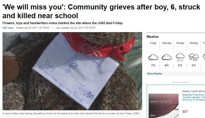
8 An urgent problem


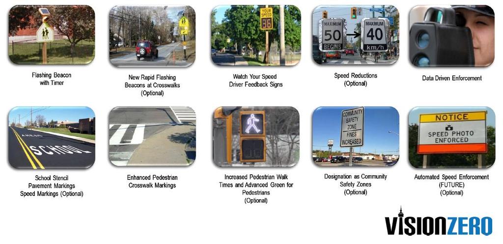
9 City of Toronto recognized that School Children as a group are vulnerable road users School Safety Zones to increase driver awareness in front of schools: Locations prioritized based on evidence-based criteria such as: School located near high collision cluster in the City Size of school catchment area = reasonable distances for students to walk or bike to school
10

11 Response of TDSB: School Traffic Management Program Provide focused support to 15 schools/year over 3 years Align with Vision Zero selection process to select schools based on evidence of need Partner with Green Communities Canada to provide support Based on School Travel Planning model; takes on a holistic Approach to reducing traffic congestion:
12 Evaluation Goal: Use data to design effective solutions, measure success, and demonstrate impact Examples: school travel survey, traffic observation, audit of school site, neighbourhood walkabout
13 Education Goal: 1. Foster the skills, confidence, and awareness to allow students to walk and wheel to school safely; 2. Raise awareness about the benefits and importance of active school travel among the school community. Examples: Pedestrian safety education, cycling skills workshops, school route mapping, educating parents about benefits of active school travel
14 Encouragement Goal: Inspiring students, parents and school staff to try active travel modes. Examples: Walk and wheel events (e.g. Winter Walk Day), walking school bus, iwalk-iwheel club.
15 Enforcement Goal: Ensure traffic and parking rules are obeyed to improve safety at and around schools Examples: monitor speed, ticket traffic violations, supervise student drop-off/pick-up locations
16 Engineering Goal: Creating safe and accessible school sites, neighbourhoods and routes to school. Examples: school zone signs, traffic and wayfinding signs, parking restrictions, bicycling parking, improving access routes to school property, crosswalk improvements, crossing guards
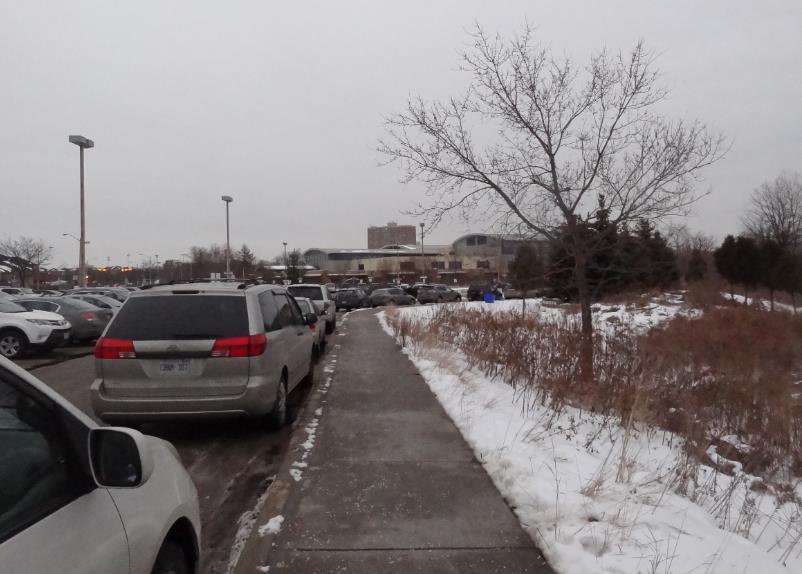
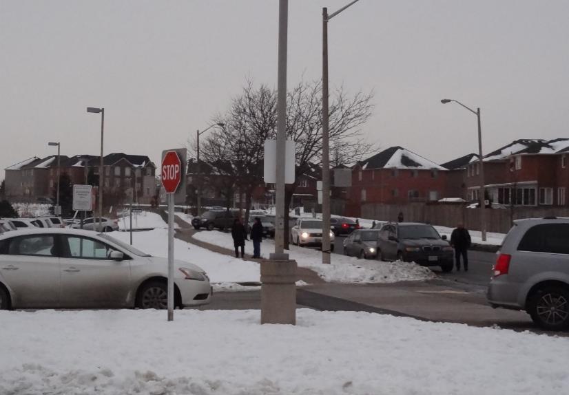
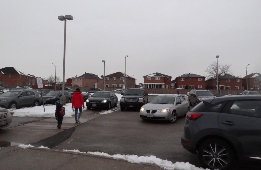
17 Early Evaluation Results: Traffic Observation: - Observed after school pick-up - Major congestion observed- cars filled parking lot and also lined surrounding streets; some cars parked at exit of driveway, obstructing sightlines for other drivers and pedestrians - Note: Drivers did not stop or park in bus loading zone - No Parking/No Stopping during school hours on school side of Humberwood Blvd in front of parking lot; however, cars parked here to pick up their children - Drivers appeared respectful of one another and of those directing traffic (two individuals directing traffic- one near bus loading zone, one near visitor parking) - Pedestrians were observed to follow sidewalks and cross with crossing guards; dangerous crossing between parked vehicles in parking lot when they had to reach cars parked on far side of driveway (i.e. along areas marked as No Parking )
18 Early Evaluation Results:
19 Early Evaluation Results: Audit of School Site/Surrounding Neighbourhood: School site - Parking lot in good physical condition; design facilitates one-way flow of traffic through the site - Pedestrian access to site with separated walkways from several points along Humberwood Blvd, and also from Humber Arboretum trails - Bike parking available - No designated drop-off/pick-up area; intended use of space otherwise wellsigned Neighbourhood - School safety zone features installed - Speed of cars along Humberwood Blvd may be a safety concern; however, drivers were observed to respect crossing guard at PXO near driveway exit


20 Early Evaluation Results: Humberwood Downs

21 Early Evaluation Results: According to data from Toronto Student Transportation Group, 68% of students attending this school live within 1.6km of the school.

22 Early Evaluation Results: Holy Child

23 Early Evaluation Results: 1.6km of the school is generally considered walking distance by the Toronto Student Transportation Group; beyond this, students qualify for bussing. There are some exceptions, including if routes are not considered walkable.
24 Upcoming Evaluations: Neighbourhood Walkabout: - To be conducted on the morning of February 21, as a committee - We will also observe the morning drop-off period at this meeting - Toronto Transportation Services have been invited to attend
25 Outcomes of the School Traffic Management Program: School Traffic Management Plan, including detailed Action Plan with action items across the 5 Es Routes to School Map for families attending this school, and variety of interactive site plan maps for schools as well as TDSB Facilities Building relationships with various partners as part of the School Traffic Management Committee, toward building a culture that is supportive of active school travel over the long term
26 Upcoming Meetings: January 30, 9:00am-10:30am: Orientation Meeting for School Traffic Management Committee February 21, 8:00am-10:00am: Neighbourhood Walkabout with Traffic Management Committee and Municipal Stakeholders April 25, 9:00am-10:30am: Progress meeting May 17, 9:00am-10:00am: Year 1 Wrap-Up (School admin and PHN only) 2018/2019 (Date TBD): Touching Base
27 Let s Envision: The Ideal School Site Define your vision What does a healthy, safe neighbourhood mean to you? (i.e. What do the streets look like? How are people travelling? Who is using the streets?) What percentage of students walk, cycle or take other modes of active transportation to school? Consider: Who will we need to get on board to help make this vision a reality? What are the key challenges/barriers? What are the current opportunities? What messaging do you think will be most effective?
28 Education and Encouragement: Question: What are some ways your school is already educating around and encouraging active school travel? Question: What are some ways that we can educate and encourage active school travel at Humberwood Downs and Holy Child? Targeted at Students Targeted at Parents/Families Targeted at School Staff (optional) Targeted at the Broader Community (optional)
29 Enforcement, Engineering, Evaluation: Question: What are the major areas for increased enforcement? Question: Are there any issues on the school property or school neighbourhood that you can think of that need improvement? Question: Are there any other pieces of evaluation needed to strengthen our Traffic Management Plan?

30 Planning for Suggested Routes to School:

31 Planning for Suggested Routes to School:

32 Planning for the Walkabout:
33 Next meeting: Wednesday February 21, 8:00am-10:00am Meet in parking lot by bus loading zone; observe the morning drop-off period at the school; plan to arrive a few minutes early if possible As a group, walk around the school neighbourhood following an observation of school drop-off time, and document/photograph issues of concern Review the draft Action Plan Comment on updated draft of Routes to School Map
SAFETY GUIDE FOR SCHOOL CHILDREN & PARENTS. toronto.ca/visionzeroto #VisionZeroTO
 SAFETY GUIDE FOR SCHOOL CHILDREN & PARENTS toronto.ca/visionzeroto #VisionZeroTO VISION ZERO ROAD SAFETY PLAN Toronto s Vision Zero Road Safety Plan is a five-year strategy for eliminating traffic-related
A GUIDE FOR ACTIVE AND SUSTAINABLE SCHOOL TRANSPORTATION IN THE EGLINTON CROSSTOWN AREA
 A GUIDE FOR ACTIVE AND SUSTAINABLE SCHOOL TRANSPORTATION IN THE EGLINTON CROSSTOWN AREA What is Active and Sustainable School Travel? Active and Sustainable School Travel refers to any form of transportation
Active Transportation Campaign. Making it Happen! Ontario EcoSchools SuperConference. February 22, 2018
 Active Transportation Campaign Making it Happen! Ontario EcoSchools SuperConference February 22, 2018 Welcome! Armi De Francia School Travel Planner Kate Berry Senior Program Manager saferoutestoschool.ca
NOTES FROM JUNIOR COUNCIL ORIENTATION SESSION HELD ON MONDAY, JANUARY 22, 2018, AT 3:30 PM IN COUNCIL CHAMBERS, CITY HALL
 CITY OF KAMLOOPS Junior Council Meeting Agenda March 12, 2018, at 3:30 pm in Council Chambers, 7 Victoria Street West, Kamloops, BC Page 1. APPROVAL OF THE AGENDA 2. MINUTES Attachment Recommendation:
Corridor Vision Workshop Summary James Madison Elementary February 22,2018
 Corridor Vision Workshop Summary James Madison Elementary February 22,2018 WHY DEVELOP THIS STUDY? Ogden City is planning for better connectivity and access to jobs and housing. Working with area partners,
4.7 Best Route to School Maps and Mapping
 4.7 Best Route to School Maps and Mapping A school route map informs families of the safest and most convenient walking and bicycling routes to school. These are often created after a Neighbourhood Walkabout
Sardis Elementary School Road Safety Plan. Produced by: Sardis Elementary School - Safer School Travel Team in cooperation with Safer City
 Sardis Elementary Road Safety Plan Produced by: Sardis Elementary - Safer Travel Team in cooperation with Safer City Plan completed in January 2016 1 Acknowledgements It takes commitment and community
Laura Secord. PAC -- Process and Action Plan Updates
 Laura Secord PAC -- Process and Action Plan Updates OVERVIEW 1. Process Review 2. Stakeholder Actions 1. City of Vancouver 2. Other Stakeholders 3. School Actions 4. PAC Actions 3. Next Steps PROCESS REVIEW
SAFE ROUTES TO SCHOOL
 SAFE ROUTES TO SCHOOL Forest Ridge Elementary School Existing Conditions and ACTION PLAN > Oak Creek - Franklin Joint School District Table of Contents CONTEXT Enrollment Boundaries
EMPHASIS AREA 1: PEDESTRIANS
 EMPHASIS AREA 1: PEDESTRIANS A pedestrian is seriously injured or killed every 3 days on Toronto s roads. Pedestrian collisions involve any person that is not riding in a vehicle or on a bicycle. 26% OF
SAFE ROUTES TO SCHOOL
 SAFE ROUTES TO SCHOOL Edgewood Elementary School Existing Conditions and ACTION PLAN > Oak Creek - Franklin Joint School District Table of Contents CONTEXT Enrollment Boundaries Enrollment
EMPHASIS AREA 2: SCHOOL CHILDREN
 EMPHASIS AREA 2: SCHOOL CHILDREN A child is seriously injured or killed every 17 weeks on their way to or from school on Toronto s roads. School children are pedestrians and cyclists between the ages of
Safe Routes to School PLAN
 CONGDON ELEMENTARY Safe Routes to School PLAN SRTS Team Kick-off Meeting February 8, 2018 AGENDA Welcome and Introductions Safe Routes to School Program Overview History of SRTS work at Congdon Elementary
Barnum- Safe Routes to School Meeting #2 January 20, 2015
 Barnum- Safe Routes to School Meeting #2 January 20, 2015 1. Introductions 2. SRTS Program Overview 1. Purpose 2. Benefits 3. Background of planning Process 3. Existing Conditions Review and Summary 1.
University of Victoria Campus Cycling Plan Terms of Reference. 1.0 Project Description
 University of Victoria Campus Cycling Plan Terms of Reference 1.0 Project Description The Campus Cycling Plan, a first for the University, will provide a comprehensive and coordinated approach to support
City of Novi Non-Motorized Master Plan 2011 Executive Summary
 City of Novi Non-Motorized Master Plan 2011 Executive Summary Prepared by: February 28, 2011 Why Plan? Encouraging healthy, active lifestyles through pathway and sidewalk connectivity has been a focus
WALK Friendly Communities: Creating Vibrant, Inclusive Places for People
 WALK Friendly Communities: Creating Vibrant, Inclusive Places for People Walkers are the indicator species for vibrant communities ~ Dr. Rodney Tolley, Director, Walk21 Imagine yourself walking safely
Shifting Gears for a Healthier City.
 Shifting Gears for a Healthier City. Mississauga s Cycling Master Plan is an ambitious strategy that sets out to transform Mississauga into a city that is conducive to cycling for daily transportation
5. Pedestrian System. Accomplishments Over the Past Five Years
 5. Pedestrian System Accomplishments Over the Past Five Years The Alamo Area Metropolitan Planning Organization (MPO) and its partner agencies recognize the importance of improving pedestrian mobility.
Shifting Gears for a Healthier City
 Shifting Gears for a Healthier City Mississauga s Cycling Master Plan is an ambitious strategy that sets out to transform Mississauga into a city that is conducive to cycling for daily transportation needs.
PRINCE GEORGE S PLAZA METRO AREA PEDESTRIAN PLAN
 PRINCE GEORGE S PLAZA METRO AREA PEDESTRIAN PLAN May 28, 2008 Agenda Welcome and introductions Project overview and issue identification Planning context and strengths Design challenges and initial recommendations
Getting Your SRTS Project Funded. Ryan Snyder
 Getting Your SRTS Project Funded Ryan Snyder Steps in Submitting a Successful Application 1. Stakeholder outreach: create a SRTS coalition 2. Develop a comprehensive plan and program with all 5 Es 3. Conceive
Active Transportation Infrastructure Investment A Business Case
 Active Transportation Infrastructure Investment A Business Case In 2016, the Real Estate Foundation awarded the Capital Regional District a $50,000 grant for Shifting Gears: Land Use Change through Active
The Pedestrian Safety Action Plan
 The Pedestrian Safety Action Plan Lydia Kelly Bicycle Pedestrian Transportation Planner The San Antonio Bexar County MPO Planning Area and Partners Northeast Partnership Greater Bexar County Council of
Catalyst for Change:
 Catalyst for Change: Toronto Examples Linking Health and Transportation Presented at Walk 21 Conference Vancouver 2011 Monica Campbell, Director Healthy Public Policy Toronto Public Health 1 About Toronto
S A F E R O U T E S T O S C H O O L H E R M A N TOW N S C H O O L S A N D P R O C TO R S C H O O L S P L A N A P P R OVA L S
 S A F E R O U T E S T O S C H O O L H E R M A N TOW N S C H O O L S A N D P R O C TO R S C H O O L S P L A N A P P R OVA L S WHAT IS SAFE ROUTES TO SCHOOL? In 1969, nearly 50% of children walked or rode
Kelowna On the Move. Pedestrian and Bicycle Master Plan
 Kelowna On the Move Pedestrian and Bicycle Master Plan Executive Summary April 2016 Purpose of the Plan The Pedestrian and Bicycle Master Plan identifies infrastructure, planning, and policy requirements
Bringing together community and health. Physical Activity and Nutrition Unit Office of Statewide Health Improvement Initiatives
 Bringing together community and health. Physical Activity and Nutrition Unit Office of Statewide Health Improvement Initiatives Physical Activity and Nutrition Unit Office of Statewide Health Improvement
AGENDA. 5. Next Steps a. Survey Distribution b. Draft Action Plan/Recommendations c. Review at next meeting in advance of document preparation
 Congdon Elementary Safe Routes to School Plan Update SRTS Team Meeting #2-Walk Audit March 21, 2018, 3:00 p.m. Congdon Elementary School Art Room-Duluth, MN 1. Welcome and Introductions 2. SRTS Review
Agenda. Overview PRINCE GEORGE S PLAZA METRO AREA PEDESTRIAN PLAN
 PRINCE GEORGE S PLAZA METRO AREA PEDESTRIAN PLAN May 28, 2008 Agenda Welcome and introductions Project overview and issue identification Planning context and strengths Design challenges and initial recommendations
Pinellas County Safety Initiatives
 Florida Department of TRANSPORTATION Pinellas County Safety Initiatives Whit Blanton, FAICP Pinellas County MPO A Distinctive County A unique geography Multi-jurisdictional Key demographics seniors and
Let Get Moving! Age-Friendly Seniors Summit, Nov
 Let Get Moving! Age-Friendly Seniors Summit, Nov 3 2017 Presented by: Margaret Denton, Ph.D Chair, Hamilton s Age Friendly Governance Committee Board Member, Hamilton Council on Aging & Professor Emeritus,
Tuesday, September 25 th Mount Holly Municipal Complex 400 East Central Avenue 5:30pm to 7:30pm. Activity Stations o Where do you Live?
 Meeting Information Overview The public workshop for the Mount Holly Comprehensive Bicycle Plan occurred on September 25, 2018. The drop-in workshop allowed attendees to participate in a series of interactive
Summary Report: Built Environment, Health and Obesity
 Research and education Built Environment Edmonton Project Summary Report: Built Environment, Health and Obesity Introduction In 2007 the Canadian Institutes of Health Research and the Heart and Stroke
Montana Safe Routes to School. Encouraging Active Lifestyles
 Montana Safe Routes to School Encouraging Active Lifestyles SRTS Coordinator Taylor Lonsdale, PE taylor.lonsdale@coe.montana.edu (406) 994-7031 Call me! It s my job to help you. The need for Safe Routes
STONY PLAIN ROAD STREETSCAPE
 Jasper Place Revitalization Strategy: Vision The people involved in the Jasper Place Revitalization Strategy envision: Goal 1: Feeling safe in our community Create a community where feeling safe is common--where
AIRPORT ROAD ENVIRONMENTAL ASSESSMENT
 WELCOME TO PUBLIC INFORMATION CENTRE #1 AIRPORT ROAD ENVIRONMENTAL ASSESSMENT From Braydon Boulevard/Stonecrest Drive to Countryside Drive November 23, 2017 6:30 PM 8:30 PM Please sign in and fill out
About the Studio. Edward J. Bloustein School of Planning and Public Policy - Rutgers University
 About the Studio Edward J. Bloustein School of Planning and Public Policy - Rutgers University Purpose of studio: Help City of Bayonne apply for Safe Routes to School (SRTS) funding by producing a School
EXECUTIVE SUMMARY. Vision
 Vision Walking and bicycling in Salt Lake City will be safe, convenient, comfortable, and viable transportation options that connect people to places, foster recreational and economic development opportunities,
BUILT FOR WALKING: SAFE ENVIRONMENTS FOR ACTIVE SCHOOL TRANSPORTATION
 TS4.1 BUILT FOR WALKING: SAFE ENVIRONMENTS FOR ACTIVE SCHOOL TRANSPORTATION June 24, City-School Boards Advisory Committee Linda Rothman, BScOT, PhD, Post-Doctoral Fellow, York University, School of Kinesiology
PEDESTRIAN ACTION PLAN
 CITY OF SANTA MONICA PEDESTRIAN ACTION PLAN DRAFT OCTOBER 2015 Safe Streets Santa Monica, December 3, 2015 Beth Rolandson, AICP Principal Transportation Planner Strategic + Transportation Planning, Planning
PEDESTRIAN ACTION PLAN
 CITY OF SANTA MONICA PEDESTRIAN ACTION PLAN DRAFT OCTOBER 2015 City Council, February 23, 2016 Beth Rolandson, AICP Principal Transportation Planner Mobility Division, Planning and Community Development
Safe Routes to School
 Safe Routes to School Amy Paxton-Aiken, Center TRT University of North Carolina Chapel Hill, NC and Ian Thomas, Executive Director PedNet Coalition Columbia, MO Housekeeping If you are calling in on a
CITY OF OAK CREEK SAFE ROUTES TO SCHOOL ACTION PLAN. East Middle School
 CITY OF OAK CREEK SAFE ROUTES TO SCHOOL ACTION PLAN East Middle School CITY OF OAK CREEK SAFE ROUTES TO SCHOOL ACTION PLAN East Middle School Why Safe Routes to School? Safe Routes to School ( SRTS ) is
RESTRICTED ROADS (20 MPH SPEED LIMIT) (SCOTLAND) BILL. 1. Is reducing the speed limit to 20mph the best way of achieving the aims of the Bill?
 (SCOTLAND) BILL. 1. Is reducing the speed limit to 20mph the best way of achieving the aims of the Bill?") RURAL ECONOMY AND CONNECTIVITY COMMITTEE RESTRICTED ROADS (20 MPH SPEED LIMIT) (SCOTLAND) BILL SUBMISSION FROM CYCLE STIRLING Questions 1. Is reducing the speed limit to 20mph the best way of achieving
RURAL ECONOMY AND CONNECTIVITY COMMITTEE RESTRICTED ROADS (20 MPH SPEED LIMIT) (SCOTLAND) BILL SUBMISSION FROM CYCLE STIRLING Questions 1. Is reducing the speed limit to 20mph the best way of achieving
SCHOOL TRAVEL PLANNING Walking in Partnership for Supportive Environments ACT Canada Sustainable Mobility Summit 2017
 SCHOOL TRAVEL PLANNING Walking in Partnership for Supportive Environments ACT Canada Sustainable Mobility Summit 2017 Presented by Emily Van Kesteren Public Health Nurse Middlesex-London Health Unit Active
MEET IN THE STREET MOVING TO ZERO
 WE MEET IN THE STREET MOVING TO ZERO Tips for sharing the street Traffic deaths are preventable. We need your help getting the message out. 2 A NEW PLAN A NEW PLAN Philadelphia is proud to adopt Vision
Sebastopol Charter School Traffic Management Plan
 Sebastopol Charter School The serves as the working document in support of these essential goals: to ensure the safety and efficiency of student arrival to and departure from school to ensure the safety
Vision Zero Advocate Conference 2018
 Vision Zero Advocate Conference 2018 Pedestrian and Cyclist Safety in Toronto: From Evidence to Practice Kate Bassil Associate Director (A) Healthy Public Policy Toronto Public Health 1 Building Healthy
PEDALING FORWARD. A Glance at the SFMTA s Bike Program for SFMTA.COM
 PEDALING FORWARD A Glance at the SFMTA s Bike Program for 2017-2021 SFMTA.COM INTRODUCTION About This Booklet More people from all walks of life see their bicycle as a more convenient way to get where
Chapter 14 PARLIER RELATIONSHIP TO CITY PLANS AND POLICIES. Recommendations to Improve Pedestrian Safety in the City of Parlier (2014)
") Chapter 14 PARLIER This chapter describes the current status and future plans for biking and walking in the City of Parlier. RELATIONSHIP TO CITY PLANS AND POLICIES The Parlier General Plan is the primary
Chapter 14 PARLIER This chapter describes the current status and future plans for biking and walking in the City of Parlier. RELATIONSHIP TO CITY PLANS AND POLICIES The Parlier General Plan is the primary
20mph in Edinburgh. Phil Noble
 20mph in Edinburgh Phil Noble Structure of Presentation Where have we come from? South Edinburgh Pilot results Citywide 20 - strategy, consultation, implementation IMAGE? 2 20mph zones and pilot area (2012)
Summary Report. Vision Zero. Road Safety Strategic Plan
 Summary Report Vision Zero Road Safety Strategic Plan 2018-2022 This page is intentionally left blank Table of Contents A Message from the Regional Chair... 1 Introduction... 3 Quick Facts... 4 Stakeholders...
SCHOOL TRAVEL PLAN. Cloverdale Traditional School
 Cloverdale Traditional School Transportation and Development Division 28 December 2017 Contents Program Funders... 4 Introduction... 5 Summary... 5 Background... 5 School Travel Planning... 5 The School
Introduction. Who is WILMAPCO. Why are walkable communities important
 Walkable Community Workshops Round 1 April 2005 SPONSORED BY WILMAPCO AND CCOBH CITY OF NEW CASTLE EDGEMOOR GARDENS CIVIC ASSOCIATION WITH FUNDING BY DELAWARE DEPARTMENT OF TRANSPORTATION AND THE DELAWARE
Safe Routes to School in New Jersey
 Safe Routes to School in New Jersey The need for Safe Routes to School 1. Fewer kids today walk and bike to school 2. Unintended consequences have resulted 3. SRTS programs can be part of the solution
Transportation Master Plan Advisory Task Force
 Transportation Master Plan Advisory Task Force Network Alternatives & Phasing Strategy February 2016 BACKGROUND Table of Contents BACKGROUND Purpose & Introduction 2 Linking the TMP to Key Council Approved
Tonight is for you. Learn everything you can. Share all your ideas.
 Strathcona Neighbourhood Renewal Draft Concept Design Tonight is for you. Learn everything you can. Share all your ideas. What is Neighbourhood Renewal? Creating a design with you for your neighbourhood.
Multi-Modal Transportation Solutions for Today's Students: Sustainable Transportation Model for Tomorrow
 1 Multi-Modal Transportation Solutions for Today's Students: Sustainable Transportation Model for Tomorrow Org STATS Single legal entity with 21 employees Board of Directors 4 Directors from each Board
Bristol City Council has produced a draft Bristol Transport Strategy document.
 Bristol Transport Strategy Summary Document Introduction Bristol City Council has produced a draft Bristol Transport Strategy document. The Strategy fills a gap in transport policy for Bristol. We have
Creating Walkable Communities: January 19, FMW SHIP: Encouraging Healthy Lifestyles in Diverse, Rural Communities!
 Creating Walkable Communities: a Health in All Policies Approach January 19, 2016 The goal of the Statewide Health Improvement Program (SHIP) is to help Minnesotans live longer, healthier, better lives
INFORMATION TOOL KIT
 CANADA ROAD SAFETY WEEK 2017 INFORMATION TOOL KIT Thank you for being involved in Canada Road Safety Week. With your participation, we can spread the word about this special week and why it is an important
ACTIVE TRANSPORTATION
 Increasing ACTIVE TRANSPORTATION in Uxbridge Monday, September 21, 2015 Trudy Ledsham Suzanne Kershaw Surgeon General s Call to Action 50% of trips to Uxbridge High School are by car (DMG, TTS 2011) 2014
Perryville TOD and Greenway Plan
 Perryville TOD and Greenway Plan Greenway Glossary Pathway: A bicycle and pedestrian path separated from motorized vehicular traffic by an open space, barrier or curb. Multi-use paths may be within the
Dangerous Driving Behaviours Near Schools and Child Pedestrian-Motor Vehicle Collisions
 Dangerous Driving Behaviours Near Schools and Child Pedestrian-Motor Vehicle Collisions May 28, 2015 Alison Macpherson, York University Linda Rothman, York University, Hospital for Sick Children Ron Buliung,
WELCOME. City of Greater Sudbury. Transportation Demand Management Plan
 WELCOME City of Greater Sudbury Transportation Demand Management Plan Public Consultation Session St. Andrew s Place, Activity Hall 111 Larch Street Wednesday September 13, 2017 6:00 to 8:00 pm Welcome
Launceston's Transport Futures. Greater travel options for the people of Launceston
 Launceston's Transport Futures Greater travel options for the people of Launceston Final Draft 13 Jan 2014 1 Page Number Executive summary 3 What is Transport Futures? 4 Vision 6 Economy, access and liveability
POLICY AGENDA For Elder Pedestrian Safety
 POLICY AGENDA For Elder Pedestrian Safety Older adults and people with disabilities often have mobility, cognitive, and sensory limitations that affect their behavior as pedestrians and place them at risk
Public Information Centre
 WELCOME Public Information Centre Father Tobin Road Lougheed Middle School - Library Wednesday November 7, 2012 7:00 p.m.to 9:00 p.m. Please sign in Neighbourhood Traffic Calming Guide Background The City
CHAIR AND MEMBERS CIVIC WORKS COMMITTEE MEETING ON APRIL 25, 2016
 TO: FROM: SUBJECT: CHAIR AND MEMBERS CIVIC WORKS COMMITTEE MEETING ON APRIL 25, 2016 JOHN BRAAM, P. ENG. MANAGING DIRECTOR, ENVIRONMENTAL & ENGINEERING SERVICES AND CITY ENGINEER SCHOOL ZONE SPEED LIMIT
TULARE COUNTY ASSOCIATION OF GOVERNMENTS
 TULARE COUNTY ASSOCIATION OF GOVERNMENTS Workshop: Creating Bikeable, Walkable Communities Wednesday, June 7, 2017 REVIEW OF THE 2016 REGIONAL ACTIVE TRANSPORTATION PLAN TCAG - 559-623-0450 210 N. Church
Montford Drive Parking & Circulation Study
 Montford Drive Parking & Circulation Study Parking & Circulation Study Follow up to the Area Plan based on what we heard Purpose 1 2 3 4 To look closer and evaluate parking and network related issues (including
Creating Safe Routes to School Programs for Tribal Communities
 Creating Safe Routes to School Programs for Tribal Communities Kristin Haukom, M.P.H. August 24, 2016 1 Background on the Guide Created by the Safe Routes to School Technical Assistance Resource Center
Woodward Hill Elementary School School Safety and Operation Review
 Address: 6082-142 nd Street Surrey, BC, V3X 1C1 Site Visit: March 7, 2011 Principal Anne Mackie Report Date: November 25, 2011 Phone: (604) 594-2408 Email: Mackie_A@sd36.bc.ca The following report is one
GRAHAM PEDESTRIAN TRANSPORTATION PLAN
 GRAHAM PEDESTRIAN TRANSPORTATION PLAN Chapter 1 I 1.1 Scope and Purpose n March of 2005, the City of Graham contracted with Greenways Incorporated (GWI) to create a Pedestrian Transportation Plan. The
Pedestrian Crosswalk Audit
 1200, Scotia Place, Tower 1 10060 Jasper Avenue Edmonton, Alberta T5J 3R8 edmonton.ca/auditor Pedestrian Crosswalk Audit June 19, 2017 The conducted this project in accordance with the International Standards
TORONTO S ROAD SAFETY PLAN
 2017-2021 TORONTO S ROAD SAFETY PLAN TRANSPORTATION SERVICES CITY OF TORONTO 2017-2021 TORONTO S ROAD SAFETY PLAN MAYOR, CITY OF TORONTO As our city grows, helping people move around quickly and efficiently
WalkSafe Vocabulary Matching. 1 pedestrian A marked place to cross the street. 2 intersection A person who is walking. 3 crosswalk. 4 curb.
 WalkSafe Vocabulary Matching Name Directions: Draw a line from the vocabulary word to its definition. 1 pedestrian A marked place to cross the street. 2 intersection A person who is walking. 3 crosswalk
PROJECT OVERVIEW. 20th Avenue Project Limits (Lincoln Way to Wawona St)
") PROJECT OVERVIEW In 2014, San Francisco adopted Vision Zero as City policy, with a commitment to eliminate all traffic deaths in the City by 2024. nue Project Limits (Lincoln Way to St) Collision data
PROJECT OVERVIEW In 2014, San Francisco adopted Vision Zero as City policy, with a commitment to eliminate all traffic deaths in the City by 2024. nue Project Limits (Lincoln Way to St) Collision data
Use this guide to learn more about walkability and how you can make your community safer to walk
 Walkability Guide Do You Enjoy Walking In Your Community? Use this guide to learn more about walkability and how you can make your community safer to walk 2 About This Guide Circulate San Diego believes
Leaside Traffic Calming Plan Update. Community Meeting 2 November 22, :00 PM
 Leaside Traffic Calming Plan Update Community Meeting 2 November 22, 2016 7:00 PM Welcome and Study Background Welcome and Thank You! Study background from LPOA s perspective: Why are we doing this study?
Vision Zero Task Force February 28, Collision Landscape Analysis
 Vision Zero Task Force February 28, 2017 Collision Landscape Analysis Welcome! What happened since our last Task Force meeting: City Council adopted the Vision Zero Resolution Applied for an OTS grant
City of Toronto Complete Streets Guidelines
 Round One This is a summary of the Complete Streets Guidelines Survey posted on June 18 th, 2015 and live until July 2 nd, 2015. The survey was designed to solicit feedback on the draft Complete Streets
Durham Vision Zero: Strategic Road Safety Action Plan
 If you require this document in an accessible format, please contact 905-666-8116 ext. 4733 September 11, 2017 Workshop #1 Durham Vision Zero: Strategic Road Safety Action Plan Introduction Region of Durham
Arlington s Master Transportation Plan
 Arlington s Master Transportation Plan The Master Transportation Plan (MTP) Adopted in eight parts Goals & Policies element and MTP Map adopted in 2007 Bicycle, Pedestrian and Demand and Systems Management
Vallecito Elementary School. Travel Plan
 Vallecito Elementary School Travel Plan TABLE OF CONTENTS 1. PURPOSE... 1 1.1. SR2S PLANNING, IMPLEMENTATION AND MONITORING... 1 1.2. MARIN COUNTY MEASURE A... 1 2. VALLECITO ELEMENTARY SCHOOL PROFILE...
A CHANGING CITY. of Edmonton, it is essential that it reflects the long-term vision of the City.
 A CHANGING CITY By the year 2040, Edmonton will be home to more than 1 million people. To accommodate growth and support a healthy and compact city, we need a new approach to development/redevelopment
Franklin Boulevard Traffic Calming Study. Public Meeting #1 October 11, 2017
 Franklin Boulevard Traffic Calming Study Public Meeting #1 October 11, 2017 Agenda Welcome and Introductions Project Overview Potential Improvements Map Exercise Report Out NOACA Technical Assistance (TA)
A Complete Streets Policy for Saratoga Springs. Presented By: Shared Access Saratoga
 A Complete Streets Policy for Saratoga Springs Presented By: Shared Access Saratoga April 17, 2012 Agenda 1. Introduction to Complete Streets (CS) 2. Shared Access Saratoga 3. Why is CS Important 4. What
MAKING BROWARD COUNTY SAFER FOR PEDESTRIANS. Thursday, May 29, 2014
 MAKING BROWARD COUNTY SAFER FOR PEDESTRIANS Thursday, Info@UrbanHS.com Brought to you by: Sponsored by: 0 Workshop was put together with a planning committee: Workshop was put together in collaboration
April 30 th, Reducing the Risks to Child Pedestrians
 April 30 th, 2018 Reducing the Risks to Child Pedestrians Technical Tips Audio is broadcast through computer speakers Download resources in the File Share pod (above the slides) If you experience audio
SAFE ROUTES TO SCHOOL (SR2S)
") SAFE ROUTES TO SCHOOL (SR2S) In partnership with Burbank Unified School District (BUSD) & City of Burbank George Washington Elementary School Thomas Jefferson Elementary School John Muir Middle School
SAFE ROUTES TO SCHOOL (SR2S) In partnership with Burbank Unified School District (BUSD) & City of Burbank George Washington Elementary School Thomas Jefferson Elementary School John Muir Middle School
Public Event 1 Community Workshops
 Public Event 1 Community Workshops Nov. 24 & Dec. 3, 2016 Welcome Workshop Purpose We re looking to you for ideas and insights to help guide future transportation infrastructure planning in the Park Lawn
Appendix C 3. Bicycle / Pedestrian Planning
 Appendix C 3. Bicycle / Pedestrian Planning BICYCLE/PEDESTRIAN PLANNING 2005 Master Plan GOAL: Provide for safe and convenient bicycle and pedestrian circulation throughout the City. Develop a city-wide
Living Streets response to the Draft London Plan
 Living Streets response to the Draft London Plan Contents Living Streets response to the Draft London Plan... 1 About Living Streets... 2 Summary... 2 Consultation response... 3 Chapter 1: Planning London
Castro Valley Municipal Advisory Council March 19, 2018
 Castro Valley Municipal Advisory Council March 19, 2018 1 Background 2 Draft Bicycle Vision and Pedestrian Networks 3 Next Steps 4 Updates Agenda 2 PROJECT AREA: Unincorporated Areas of Alameda County
Summary Report School Walking & Bicycling Audits. Mesa County Regional Transportation Planning Office
 Summary Report School Walking & Bicycling Audits Mesa County Regional Transportation Planning Office This page left blank intentionally WALKING & BICYCLING AUDIT SUMMARY 2 Executive Summary Background:
VISION ZERO ACTION PLAN
 PALM BEACH Transportation Planning Agency VISION ZERO ACTION PLAN TPA Advisory Committee Meetings March 2019 PURPOSE Present the Data Analysis Key Findings and the Action Items from the Draft Action Plan
Safe Routes to School Grant Application Phase I March 2014
 Safe Routes to School Grant Application Phase I March 2014 Page 1 The City of Mission is requesting grant funding to create a Safe Routes to School Plan which will encompass all of the existing elementary
July 5, Arthur R. Ware, Jr. Elementary School 2017 Safe Routes to School Walkabout Report
 July 5, 2017 Arthur R. Ware, Jr. Elementary School 2017 Safe Routes to School Walkabout Report 1 Walkabout Report Introduction On April 28, 2017, City, School, and SAWMPO staff met to conduct a Safe Routes