Walking without Walls. Slow Marathon: Dufftown to Huntly
|
|
|
- Teresa Bradford
- 5 years ago
- Views:
Transcription

1 Walking without Walls Slow Marathon: Dufftown to Huntly


2 Walking without Walls Slow Marathon: Dufftown to Huntly Deveron Projects The Studio, Brander Building, Huntly, AB54 8BR, Scotland T: E: Photograpy: Christine Sell, Ross Fraser McLean, Claudia Zeiske and others Design: Mou Design

3 Introduction Slow Marathon is an annual 42km/26miles themed walking route developed by Deveron Projects. Celebrating the human pace, it is both an endurance event as well as a poetic act that brings together friendship, physical activity and the appreciation of our landscapes in their geo-political settings. The Walking without Walls project formed two marathon length walks. One in Gaza and the other along the river Isla from Dufftown via Keith to Huntly, presented in this book. Walking without Walls is a digitally driven exchange project by Rachel Ashton (Huntly, Scotland) and May Murad from Gaza. In their explorations, both artists investigated, recorded and shared native plants with healing powers along the way. While Rachel negotiated her way with landowners and farmers, May dealt with the complexities of living in an occupied territory. Learning about each other s life and landscape, the two artists developed a marathon length route in their respective places. One in Gaza and the other along the river Isla from Dufftown via Keith to Huntly, presented in this book. 2 3

4 Slow Marathon: Dufftown to Huntly Starting Point 4 5


5 Our starting point is the B9014 turning to Parkmore. We walk up the hill to the holiday homes. Here we go through a gate, along a wooded path for ca 1km. At the cross roads we turn left down the hill back to the main road. The White Wood 6 7


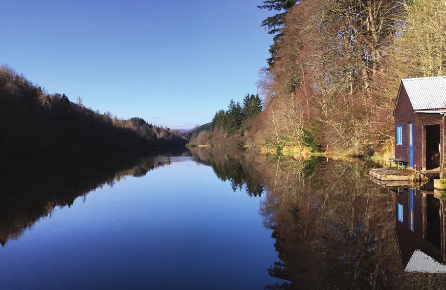
6 Slow Marathon 2018 Dufftown to Huntly We cross the B9014, turn right and then sharp left down the hill along a path to the small railway crossing. After ca 2km along Loch Park we reach the Outdoor centre where we meet the River Isla. Walking another 2km along the Isla we reach Bortiphnie church. TAKE CARE WHILE CROSSING The Keith and Dufftown Heritage Railway, also called the Whisky Line runs for 18 km from Keith to Dufftown on summer weekends. 8 9
7 10 11


8 Slow Marathon 2018 Dufftown to Huntly Soon after, we meet a junction with walking signs. Nearby is the St. Fumac well. We turn left up the hill and soon right again through a gate opposite Drummuir Castle. From here it is about 1km along a wooded avenue.we turn left onto the road. According to local tradition, St Fumac bathed every morning, summer and winter, in a copious spring still to be seen in the manse garden. By way of penance went round the bounds of the parish on his knees praying that its inhabitants might be preserved from the plague. In later times the wooden image of the saint was carefully kept in the parish, and used to be annually washed in his well on his festival day, 3rd May. TAKE CARE: DANGEROUS ROAD Try to walk on the verge 12 13


9 Dufftown to Huntly After ca 3km on the road we turn right onto the path to Auchinachy. We pass a gate after 20m


10 Slow Marathon 2018 Dufftown to Huntly At first the route is on rough ground, then on a small road past Coldhome for ca 2.5km. We follow the green signs to Keith and turn left up the hill at the Keith Square/Auld Brig sign. After 1km we reach the town and follow a road through housing estates turning right to the Catholic church. In the distance we see Blackhillock substation which is capable of carrying up to 1200MW of electricity through a 100 mile cable from Caithness. St Thomas Roman Catholic Church was built in the early 1830s and designed by Father Walter Lovi, who is also said to have designed churches in Wick, Braemar and Glenlivet


11 Dufftown to Huntly Carry on down the hill until we reach Keith Square for a well deserved break. Walk around it to ensure your full mileage at the end. Plenty of cafés here. PUBLIC TOILETS HERE Keith is home to the Original Kilt School of Scotland, the only one of its kind in the world


12 Slow Marathon 2018 Dufftown to Huntly Our path crosses the A96 at the corner shop and continues opposite along Bridge Street/ Edindiach Road for 1.3km until we see a sign to Dunnyduff/ Ballindalloch Hill, leading us down to the Isla again. After about 500m we get back up on the small road and continue past the Dunnyduff signs to a car park at the start of the Balloch forest. Balloch Hill offers the finest views in Moray. On a clear day they say you can see seven counties from here! 20 21
13 22 23


14 Slow Marathon 2018 Dufftown to Huntly From the Ballindalloch car park we follow the BLACK route. First ca 300m straight ahead, then a right turn (at black sign) along forest roads for ca 2km until we meet another track. Continue right following the black route signs. e. Turn right again at the junction and walk for ca 800m until we meet a path to the left with a black sign. Turn left down the hill here on the path with blue/grey gravel. In this area we are crossing the border from Moray to Aberdeenshire


15 After Sittinghillock farm we get to a T-junction. We turn right here and then fork left when the road splits until we get to North Riggins


16 Slow Marathon 2018 Dufftown to Huntly Leaving North Riggins to the left, we continue along the rough path for ca 300m and turn left at a gate. The path leads us through Auchanachie Forest past the castle to the minor road. Auchanachie is a small minor Gordon tower house, grandly described as a castle. It has stood on the hill above Ruthven, through troubled times since the 1500s, hence inscription over the front door from our enemies defend us O Christ. It is known for its large lum and supposedly haunted by a nun
17 30 31


18 Slow Marathon 2018 Dufftown to Huntly Here we turn left; pass through the village of Ruthven and continue on the road for ca 1km. We turn right at the sign to Whitehill. We pass Whitehill Farm and after a couple of gates reach the Bin Forest. We continue for almost 2km south until we get to a forest road junction where we turn right. The Bin takes its name from the Gaelic for hill or mountain bheinn (pronounced ben ). It was first planted in the 1840s with fir tree seeds brought back from North America by the famous Scottish plant-hunter David Douglas
 we turn left again and continue for 1km.")
; walk for 500m until")


19 Slow Marathon 2018 Dufftown to Huntly After 300m (black sign) we turn left again and continue for 1km. Turn right at a T-junction and after 200m take the next left (now signs are blue); walk for 500m until we reach the White Wood at a junction on our left. To achieve the full marathon length of the route, you must walk around the White Wood at least once. The White Wood is a living monument to peace which will develop over 300 years. As a site of reflection, it was created by the community of Huntly and artist Caroline Wendling with oaks from Germany, stones from France and over 1500 native Scottish plants. CAUTION: EASY TO GET LOST! 34 35

20 Dufftown to Huntly 36 37


21 Slow Marathon 2018 Dufftown to Huntly After a short detour to the White Wood we turn back and continue on the main path for 1km past Cleanbrae until we reach the B9022 road. We cross the road; turn left and soon right towards the Castle Hotel. At the hotel we walk through its grounds and down to Huntly Castle over the Elgin Bridge. From the Castle it is only a few minutes back to Huntly Square. Walk around it a couple of times to achieve your full 42k marathon walk. Huntly Castle is a noble ruin, famous for both the quality of its architecture and for its eventful history. The earls of Fife built the original castle around 1190, to guard the crossing-point where the rivers Bogie and Deveron meet. But it was the mighty Gordons who made the stronghold their own from the 1300s. The surviving remains tell the story of the development of the castle, from the motte and bailey of the 1100s, through the tower house of the later Middle Ages, to the stately stone palace of the Jacobean era

22 CONGRATULATIONS YOU HAVE ACHIEVED YOUR MARATHON 40 41

23 Slow Marathon is an annual 42km/26miles themed walking route developed by Deveron Projects. Celebrating the human pace, it is both an endurance event as well as a poetic act that brings together friendship, physical activity and the appreciation of our landscapes in their geo-political settings.
Clyde Walkway Community Links: Nemphlar Moor Road to Braidwood
 Clyde Walkway Community Links: Nemphlar Moor Road to Braidwood Nemphlar Moor Road to Braidwood Digital Trail Difficulty (out of 3) 2 Distance Main route to Braidwood (shortest) 2.5km, 5km return. Detours
Danbury Words and pictures by Laurie Page of the Public Rights of Way team at Essex County Council.
 Danbury Words and pictures by Laurie Page of the Public Rights of Way team at Essex County Council. An undulating walk from Danbury village to the bluebells at the National Trust property of Blakes Wood.
The Mendip Way. Route Directions and Maps Wells to Frome
 The Mendip Way Route Directions and Maps Wells to Frome Website: www.mendiphillsaonb.org.uk Email: mendip@mendiphillsaonb.org.uk Facebook & Twitter: @MendipHillsAONB Phone: 01761462338 1 Wells to Shepton
Approximate distance: 10 miles For this walk we ve included OS grid references should you wish to use them. Start. End
 Approximate distance: 10 miles For this walk we ve included OS grid references should you wish to use them. 2 3 Start End 1 N W E S Reproduced by permission of Ordnance Survey on behalf of HMSO. Crown
Walk 7: Watchet to washford
 Walk 7: Watchet to washford Length: Moderate - 7.5 miles / 12 km Good For: Theme: History Duration: 2-3 hours depending on speed of walking Notes: This is a moderate to difficult walk in places, with steps,
For more information and to buy this book click here ISBN: CICERONE. Guides for walkers, trekkers, mountaineers, climbers and cyclists
 For more information and to buy this book click here ISBN: 9781852845377 CICERONE Guides for walkers, trekkers, mountaineers, climbers and cyclists www.cicerone.co.uk WALK 5 Ouston and Urpeth Distance
Key Information. Self-Guided Walk Exploring Sedbergh
 Self-Guided Walk Exploring Sedbergh A great short walk - ideal for an early evening in summer. This is a lovely circuit of Sedbergh visiting some of the historic buildings as well as ambling by the river
Bonnie Prince Charlie Walk
 Bonnie Prince Charlie Walk A waymarked route from Ashbourne to Derby to celebrate the 60th anniversary (1995) of the formation of the Ramblers' Association. This route follows the general direction of
Lincolnshire Limewoods Walks. Woodhall Spa. A circular walk of 13km (8 miles)
") Lincolnshire Limewoods Walks Woodhall Spa A circular walk of 13km (8 miles) Introduction The Lincolnshire Limewoods is an area between Wragby, Bardney and Woodhall Spa. It is a fantastic place to explore
Lincolnshire Limewoods Walks Woodhall Spa A circular walk of 13km (8 miles) Introduction The Lincolnshire Limewoods is an area between Wragby, Bardney and Woodhall Spa. It is a fantastic place to explore
Slindon Folly - South Downs, West Sussex
 Slindon Folly - South Downs, West Sussex Starts at Park road-side near entrance to Slindon College 2 hours 15 minutes 4.5miles 7.2km Easy ID: 0.1598 Developed by: Chris Mumford Checked by: Rockpit www.ramblersroutes.org
The Hundred Parishes
 The Hundred Parishes Walks from railway stations number 9 6.4 miles (10kms) from Bishop s Stortford to Stansted Mountfitchet Start: Bishop s Stortford station (Grid Reference TL492209) (ample parking and
9.5 km Circular 3 hours
 RANMORE CIRCULAR A 6 mile (9.5km) circular walk from Boxhill and Westhumble Station in the village of Westhumble, passing through part of the Polesden Lacey Estate, Ranmore Common and Denbies Vineyard.
There are toilets at Manningtree Station, Flatford (close to the hump back bridge) and in Dedham.
 and in Dedham.") Arriving by Train Main Features of the Walk Outline Route Employs particularly attractive paths, many of which offer impressive views across Dedham Vale. Includes a section along the tidal section of the
Arriving by Train Main Features of the Walk Outline Route Employs particularly attractive paths, many of which offer impressive views across Dedham Vale. Includes a section along the tidal section of the
How much do you know about Scottish castles? TAKE THIS QUIZ AND FIND OUT! COMPLETE THE SENTENCES WITH THE PASSIVE FORMS OF THE VERBS IN BRACKETS.
 Scottish Castles This work is a result of the project titled Increasing ELT Effectiveness accepted by Foundation for the Development of the Education System (FRSE) Project number: 2014-1-PL01-KA101-000712
Clyde Walkway Community Links: Crossford Stonebyres Nemphlar- Kirkfieldbank
 Clyde Walkway Community Links: Crossford Stonebyres Nemphlar- Kirkfieldbank Crossford Stonebyres Nemphlar - Kirkfieldbank Digital Trail Difficulty (out of 3) 2 Distance 1. Crossford to Kirkfield Bank Bridge
NEW BEGINNINGS. We think a new job is like a blank page, the opportunities are endless. Be part of our new beginning...
 Opening Summer 2018 NEW BEGINNINGS The Fife Arms opens in 2018 and we want you to join our team as we set out on an exciting new chapter in the life of this historic hotel. We have borrowed the opening
LOCAL CIRCUIT EM1: EAST MALLING & BARMING HEATH. N 2m ROADS: Significant roads PATHS: Starting direction Barming Longsole Mission Church
 Ditton Church Scott Close LOCAL CIRCUIT EM1: EAST MALLING & BARMING HEATH 6 Community Centre F Open fields (see 'Introductory Notes') 1m 88 Direction label (as in the walk notes) East Malling Church -
Walk 2: Beamsley Beacon and Bolton Abbey
 Walk 2: Beamsley Beacon and Bolton Abbey Start and Finish: The Memorial Hall, Main Street, Addingham, LS29 0LZ, SE 079 497 The shortest walk is about 5½ miles (8.8km) The medium Walk is about 8¼ miles
Clyde Walkway Community Links: Rosebank Circular via Ashgill and Dalserf
 Clyde Walkway Community Links: Rosebank Circular via Ashgill and Dalserf Rosebank Circular via Ashgill and Dalserf Digital Trail Difficulty (out of 3) 1 Distance 7 km / 4.35 miles. Time 2 hours Terrain
THE PONTON PLOD - 27 MILE ROUTE
 THE PONTON PLOD - 27 MILE ROUTE Emergency Phone Number 07771 813514 Abbreviations: BW Bridleway X Cross immd immediately FP Footpath TL Turn left L Left thro through KG Kissing Gate TR Turn right R Right
Thornton le Dale Walks
 Thornton le Dale Walks A collection of circular walks in, and around, the village www.visitthorntonledale.co.uk Thornton-le-Dale Traders Forum and Thornton le Dale Parish Council 1 Thornton le Dale Circular
Weatherman Walking. Approximate distance: 5.5 miles For this walk we ve included OS grid references should you wish to use them. Start.
 Approximate distance: 5.5 miles For this walk we ve included OS grid references should you wish to use them. 4 1 Start End 3 2 N W E S Reproduced by permission of Ordnance Survey on behalf of HMSO. Crown
Walk 2 Village Hall - The Shippy - Woodhouse Farm - Village Hall
 Walk 2 Village Hall - The Shippy - Woodhouse Farm - Village Hall The walk is approximately 4km (2.5 miles) across fairly flat countryside with about a quarter on country lanes. It should take about 1 hour
Canillo (AND) 16/20 November 2016
 16/20 November 2016") ISU International Figure Skating Competition for Singles, Pairs and Ice Dance Canillo (AND) 16/20 November 2016 Organized by Andorra information Welcome to Andorra, the country of the Pyrenees. An independent
ISU International Figure Skating Competition for Singles, Pairs and Ice Dance Canillo (AND) 16/20 November 2016 Organized by Andorra information Welcome to Andorra, the country of the Pyrenees. An independent
9.5 km Circular 3 hours
 MEDIEVAL WAVERLEY Challenging Terrain A 6 mile (9.5km) undulating circular walk from Tilford village passing close to The Sands village and the historic ruins of Waverley Abbey. From the top of Crooksbury
Bagshot Heath and Swinley Forest
 point your feet on a new path Bagshot Heath and Swinley Forest Distance: 13 km=8 miles Region: Berkshire, Surrey Author: Botafuego Refreshments: Forest Look Out, Bagshot easy walking Date written: 17-feb-2013
Directions for Day 1: Colwood To Metchosin
 Colwood-Metchosin Page 1 of 8 Directions for Day 1: Colwood To Metchosin Start: Royal Roads University, Birds of a Feather B&B, or at Esquimalt Lagoon Finish: Your accommodation in Metchosin Time: 4-5
10 Miles Circular 5 hours
 VISIT RYEDALE PICKERING AND CAWTHORN CAMPS 10 Miles Circular 5 hours Moderate Terrain 120616 A 10 mile (16km) there and back walk from the market town of Pickering in Ryedale. The route heads north through
The North Pennines from near Langwathby
 3.6 Langwathby to Armathwaite Map panel?? Distance 12.7 miles (20.5 km) Terrain farm, woodland and riverside paths; some potentially muddy tracks; a few short sections of road Grade gently undulating Food
Skyline 10km Series Race Information 15th November, 6th December, 17th January, 14th February 11:00am Start University of Bath, Bath, BA2 7JY.
 Skyline 10km Series Race Information 15th November, 6th December, 17th January, 14th February 11:00am Start University of Bath, Bath, BA2 7JY. Important Notices New Location We are now in West Car Park!
Lincolnshire Walks. Ancaster. Three cir cular walks of2 3/4,4or 6km (11/3, 21/2 or 33/4 miles)
") Lincolnshire Walks Ancaster Three cir cular walks of2 3/4,4or 6km (11/3, 21/2 or 33/4 miles) Introduction These walks are set in the attractive countryside around the historic town of Ancaster. The town
Lincolnshire Walks Ancaster Three cir cular walks of2 3/4,4or 6km (11/3, 21/2 or 33/4 miles) Introduction These walks are set in the attractive countryside around the historic town of Ancaster. The town
HARDMOORS 26.2 WHITE HORSE HALF ROUTE DESCRIPTION - 018
 HARDMOORS 26.2 WHITE HORSE HALF ROUTE DESCRIPTION - 018 Follow Cleveland Way, keeping to the left hand path (right path is a bike trail) Ignoring any turnings to the left or right At path junction (after
Lacock Road Races - 18th June 2017, from 09:00 Lacock Playing Fields, Lacock, SN15 2LG.
 Lacock Road Races - 18th June 2017, from 09:00 Lacock Playing Fields, Lacock, SN15 2LG. Important Notices This is a Closed Roads event. As always, an event never occurs in isolation, and we must work with
Walking London: Thirty Original Walks In And Around London By Andrew Duncan
 Walking London: Thirty Original Walks In And Around London By Andrew Duncan If you are searched for a ebook by Andrew Duncan Walking London: Thirty Original Walks In and Around London in pdf format, then
Hammer Vale and Linchmere Common
 point your feet on a new path Hammer Vale and Linchmere Common Distance: 9 km=5½ miles or 6 km=3¾ miles easy walking with one steep section Region: Hampshire, West Sussex Author: Botafuego Refreshments:
Sandilands to Huttoft Bank
 Coastal Country Park Walks Sandilands to Huttoft Bank A CIRCULAR WALK OF 11KM (7 MILES) INTRODUCTION The Lincolnshire Coastal Country Park lies between Sandilands, Chapel St Leonards and Huttoft on the
Husthwaite to Byland Abbey
 Husthwaite to Byland Abbey This walk begins with a loop round the village of Husthwaite and continues towards Coxwold along a disused railway line, which is now a right of way. It passes through Coxwold
Germany Bike Adventure Mosel Rhine 2019 Individual Self-Guided 7 days / 6 nights
 Germany Bike Adventure Mosel Rhine 2019 Individual Self-Guided 7 days / 6 nights A cycling tour along the Moselle cycle route not only makes a wine connoisseur s heart beat faster. The Moselle is one of
Thornton le Dale Walks
 Thornton le Dale Walks A collection of walks in and around the village Thornton le Dale Traders Forum www.visitthorntonledale.co.uk Thornton le Dale Walks Walk 1: Beck Isle Cottage and All Saints Church
A Walk from Our Lady of Victories Church, Bowen Hills to The Cathedral of Saint Stephen
 A Walk from Our Lady of Victories Church, Bowen Hills to The Cathedral of Saint Stephen 1 0.0km 30m 185m 270m From the Start to Breakfast Creek Rd is 8 minutes This pilgrimage walk should take the average
Netherlands - Belgium - Abbeys and Beers Along the Trappist Route Bicycle Tour 2019 Individual Self-guided 7 days / 6 nights
 Netherlands - Belgium - Abbeys and Beers Along the Trappist Route Bicycle Tour 2019 Individual Self-guided 7 days / 6 nights Experience the taste of Trappist beers on this unique cycle route which takes
Waterhead Pier to Orrest Head, Windermere and Bowness
 Waterhead Pier to Orrest Head, Windermere and Bowness A 4 1 2 hour walk through Woodlands and the Troutbeck Valley with spectacular Lake and Mountain views and a lakeshore path. Walk 10 Walk 11 Walk 12
Eight Hour Coastal Tour
 Eight Hour Coastal Tour To start this coastal tour, you will be picked up at the Sea Terminal and driven north along Douglas Promenade, around Onchan Head and along the coast road to Groudle Glen. Groundle
Boating Holidays on the Caledonian Canal in Scotland
 Caledonian Canal Boating Holidays on the Caledonian Canal in Scotland Surrounded by breathtaking beautiful hillsides - the Caledonian Canal connects the highland capital of Inverness on the east coast
London to Southend-on-Sea Trek map
 FIGHT FOR EVERY HEARTBEAT London to Southend-on-Sea Trek map Route stats: 100 km (62 miles) with metres of climbing Start: Fulham Palace 9:00am Half Way / Start for 50km: CEME Centre 9.00pm Finish: Southend-on-sea
Route: Skewsby Foulrice Stearsby
 Route: Skewsby Foulrice Stearsby Distance: 7 miles Map: Explorer: 300 Howardian Hills & Malton Start (OS ref): SE625710 Park in the village of Skewsby. Walk east out of the village to the T-Junction and
Fertile farms in the heart of Kent
 55 55 Fertile farms in the heart of Kent A bright sunny day is perfect for enjoying the rich and fertile Kent countryside and outstanding views across the valley of the Great Stour to the North Downs.
This note provides information on the extent of path provision in Scotland and highlights deficiencies in current provision.
 THE PROVISION OF PATHS IN SCOTLAND This note provides information on the extent of path provision in Scotland and highlights deficiencies in current provision. Why are paths important? Paths are important
RILLINGTON TO MALTON by Tania Dickinson
 RILLINGTON TO MALTON by Tania Dickinson This walk takes you from the Vale of Pickering up on to the Wold scarp, before dropping down again through the pretty village of Settrington and joining the Centenary
THE BECK STONE Backstone Beck on Ilkley Moor
 THE BECK STONE Backstone Beck on Ilkley Moor 1 Three different routes which take in the best of the lower slopes of Ilkley Moor, with bracken, heather, a tarn (a small mountain lake) and rushing streams.
holly tree Wellhill Farm Woodyard Bramham House red kites Round House ha-ha
 This 6.4 mile walk around the magnificent Bramham Park Estate has been made possible with the active support of the owner of the Estate, Nick Lane Fox, with funding from Natural England, as part of Defra
Rhossili - Tears Point - Mewslade Bay - Talgarth's Well - Rhossili - ID: 148. Walk description:
 Walk description: A glorious walk combining thrilling cliffs with beautiful wild beaches and a bird's-eye view of the Gower peninsula from Rhossili Down. The adventurous can walk out to the Worm's Head
Redesdale Arms. A Trio of Walks
 Redesdale Arms A Trio of Walks Welcome to The Redesdale Arms Hotel The award winning 34 bedroom Redesdale Arms Hotel sits at the gateway to the Cotswolds in the High Street of the historic town of Moreton-in-Marsh.
Gainsborough and Fledborough Circular
 Trent Vale Cycle Route TVCR18 Gainsborough and Fledborough Circular Gainsborough Old Hall. One of the biggest and best preserved Medieval Manor Houses in England. Start Point: Gainsborough Marshall s Yard
Stunning Scotland. "Breathtaking views"
 "Breathtaking views" Baint Bikes welcomes you to our Stunning Scotland, Speyside and Moray coastal cycling holiday. Our carefully selected cycling routes offer the best way to see the finest sights this
Day Month Activity Accommodation
 Day Month Activity Accommodation Sat June Your designated R&G representative will meet you on arrival at Edinburgh Airport. He will assist with the collection of your hire car, provide you with detailed
Beautiful Walks from the Blue Ball Inn
 Walk No. 7 COAST AND VALLEY WALK Countisbury, Glenthorne, County Gate, Brendon, Rockford and Wilsham 10 MILES APPROX. Walking time 5 hours approx. (not including breaks)> OS Sheet 64/74 Lynton and Lynmouth.
Darwin Bradley Eilidh MacFadyen Caroline Mackinnon Sir Hugh Munro
 1 Complete the sentences with information from Chapter 1. 1 One of the least populated areas of Europe is the Highlands and Islands. 2 The highest mountain in Scotland is Ben Nevis. 3 All the mountains
TOWPATH WALK. Fold out map. inside! Revealing Oldknow s Legacy GUIDE & MAP MARPLE & MELLOR. oldknows.com
 2 TOWPATH WALK Fold out map inside! 3 4 Revealing Oldknow s Legacy GUIDE & MAP & MELLOR oldknows.com and the Peak Forest Canal in Marple SAMUEL OLDKNOW Samuel Oldknow, a Lancashire born muslin manufacturer,
Day Date Activity Accommodation. Enjoy dinner in the Greywalls Chez Roux restaurant. Enjoy dinner in the Greywalls Chez Roux restaurant
 Sample itinerary Day Date Activity Accommodation Fri 18/08/18 Arrival at your accommodation in East Lothian Enjoy dinner in the Greywalls Chez Roux restaurant Sat 19/08/18 Breakfast Golf on Gullane No.
Development Plots, Ayeon, Cragganmore, Ballindalloch, AB37 9AB Offers over 60,000
 Development Plots, Ayeon, Cragganmore, Ballindalloch, AB37 9AB Offers over 60,000 Contact us on 01479 874800 or visit Two development sites at Ayeon, Ballindalloch extending to just over 0.25 acre each
Tiny Treks Alderley Edge
 Tiny Treks Alderley Edge Start: Alderley Edge, National Trust Car Park, B5087 Macclesfield Road Alderley Edge. SK10 4UB. Facilities: WC, Parking (Pay and Display), Visitors centre, Café Walk: Approx 2miles
Although the majority of these walks are around country lanes you should still follow the Country Code:-
 With the update of the Parish Plan was a request for details of any Walks around Pillaton The following pages give several walks that I and my wife have done for many years. Please be aware that NONE OF
Lacock Road Races - 10th June 2018, from 09:00 Lacock Playing Fields, Lacock, SN15 2LG.
 Lacock Road Races - 10th June 2018, from 09:00 Lacock Playing Fields, Lacock, SN15 2LG. Important Notices This is a Closed Roads event. As always, an event never occurs in isolation, and we must work with
Cycle Tendring. Great Bicycle rides around the Brightlingsea and Manningtree area
 2 Cycle Tendring Bicycle rides around the Brightlingsea and Manningtree area Cycle Tendring Why not discover and explore the beauty of the Tendring Peninsula by bike? There s nothing like following the
Scotland The Moray Coast and Whisky Bike Tour 2019 Individual Self-guided 8 days / 7 nights
 Scotland The Moray Coast and Whisky Bike Tour 2019 Individual Self-guided 8 days / 7 nights From Inverness, the Capital of the Highlands travel east along the quiet roads of Moray. There are many historical
Green Man Ultra Route Directions 2018
 Green Man Ultra Route Directions 2018 Start-CP1 (9 miles) Community Forest Path (CFP) Frome Valley Way (FVW) From the starting line cross the playing fields diagonally to the metal gates in the hedge lined
Lloyds Banking Group Lean On Me Challenge 2017
 Lloyds Banking Group Lean On Me Challenge 2017 Mapbook West Country Walk September 21 In aid of Mental Health UK Join the Facebook Group Lean On Me Challenge for updates on the event Or follow on Twitter
Contents Section A: Before You Go...5 Section B: Homestay Guide...27 Section C: Country Guide...33
 Contents Section A: Before You Go...5 A1: Me Talking About Myself... 6 A2: Introducing My Family...8 A3: My Typical Day...10 A4: My Hometown...12 A5: Visiting Popular Tourist Attractions...14 A6: Holidays
WETHERBY CIRCULAR by Tania Dickinson
 WETHERBY CIRCULAR by Tania Dickinson This walk in lower Wharfedale includes a disused railway line at the beginning and riverside at the end, with parkland, fields, woodland and villages in between. Distance
Contents. Contents page 2. Introduction page 3. The Orkney Islands page 3. The Geographic parishes of Orphir and Stenness page 4.
 1 Contents Contents page 2 Introduction page 3 The Orkney Islands page 3 The Geographic parishes of Orphir and Stenness page 4 The Manse page 5 The Church page 5 The life of the church page 6 How we see
The main feature of this tranquil walk is a visit to the source of the Thames (the Thames head) which is in a field just 3 km from Kemble station
 which is in a field just 3 km from Kemble station") SWC Walk DRAFT Kemble circular: the source of the River Thames. The main feature of this tranquil walk is a visit to the source of the Thames (the Thames head) which is in a field just 3 km from Kemble
SWC Walk DRAFT Kemble circular: the source of the River Thames. The main feature of this tranquil walk is a visit to the source of the Thames (the Thames head) which is in a field just 3 km from Kemble
Countryside Walks. 1) Highclere Park Public Walk.
 Highclere Park Public Walk.") 1) Highclere Park Public Walk. Access: From Highclere Estate Main Entrance at Whitway, please note there is no parking on site or access for vehicles. Open: Throughout the year. Description: This footpath
1) Highclere Park Public Walk. Access: From Highclere Estate Main Entrance at Whitway, please note there is no parking on site or access for vehicles. Open: Throughout the year. Description: This footpath
This walk description is from happyhiker.co.uk
 This walk description is from happyhiker.co.uk Pendle Hill Walk From Barley Starting point and OS Grid reference Ordnance Survey map Distance Traffic light rating Barley village honesty box car park OS
What are National Parks?
 Honeypot sites What are National Parks? National Parks are protected areas of natural beauty. The areas include mountains, moorland, heathland, woodland and coasts. National Parks are not theme parks they
Harlington - Sharpenhoe - Pulloxhill
 Harlington - Sharpenhoe - Pulloxhill ID: 3676, Distance: 8 miles, Height gain: 140 Metres, Map: Explorer 193 Luton & Stevenage, Contributor: Dennis Jeanes Duration: 3 Hours 27 Mins Features Church,Great
Lincolnshire Walks. Grainthorpe. Three circular walks of 2 ¾, 9 and 9 ½ km (1 ¾, 5 ½ and 6 miles)
") Lincolnshire Walks Grainthorpe Three circular walks of ¾, 9 and 9 ½ km (1 ¾, ½ and 6 miles) Introduction Explore the coastal marshes, arable hinterland, Louth Navigation canal and the village of Grainthorpe
Lincolnshire Walks Grainthorpe Three circular walks of ¾, 9 and 9 ½ km (1 ¾, ½ and 6 miles) Introduction Explore the coastal marshes, arable hinterland, Louth Navigation canal and the village of Grainthorpe
Rhine, Wine and Culture. Rhine bike trail Strasbourg - Mainz TOUR DESCRIPTION
 Rhine bike trail Strasbourg - Mainz TOUR DESCRIPTION Rhine, Wine and Culture. Begin this diversified cycling tour in Strasbourg, the seat of numerous European institutions. The historic Old Town, which
Shepherdswell - Dover
 Shepherdswell - Dover The North Downs Way > Shepherdswell to Dover Introduction This part of the path is slightly different in character from most other parts of the path since it spends much of the time
Walks in Lenham. Three delightful walks in and around Lenham from 30 minutes to 90 minutes with map and photographic guides. l l l ABOUT LENHAM
 Walks in Lenham Three delightful walks in and around Lenham from 0 minutes to 90 minutes with map and photographic guides l l l ABOUT LENHAM The medieval village of Lenham, in the Borough of Maidstone,
LDWA SOUTH DOWNS MARATHON
 AHD ahead SDW South Downs Way BL/BR bear left/bear right TL/TR turn left/turn right SP signpost/fingerpost X cross LEG 1 - EAST DEAN to WP1 NORTON GR 470019. Open 1030 to 1300. 9.6 miles. 1.1 From village
A circular walk of or km (2 1 4 or miles)
") Grantham A circular walk of 3 3 4 or 5 3 4 km (2 1 4 or 3 1 2 miles) Introduction This relatively short circular walk, which starts in the middle of Grantham, offers plenty of variety. The route takes
Grantham A circular walk of 3 3 4 or 5 3 4 km (2 1 4 or 3 1 2 miles) Introduction This relatively short circular walk, which starts in the middle of Grantham, offers plenty of variety. The route takes
THE DRAMATHON 21 st OCT 2017 PARTICIPANT GUIDE
 THE DRAMATHON 21 st OCT 2017 PARTICIPANT GUIDE Firstly. A HUGE thanks to you for your support. We didn t think the subtle blend of great trails and fantastic whisky would be quite so popular, and we were
East Lulworth Ride Route 5
 East Lulworth Ride Route 5 Out of ar Experience - ycling in Purbeck ircular route from Wareham to Lulworth - 18 miles + Lulworth ove oombe Keynes River Frome Time needed: 3-4 hours + Grading: Moderate
This tour starts from the roundabout with the Globe sculpture in Alcester. Follow signs to Arrow and Ragley Hall.
 SHAKESPEARE COUNTRY LEISURE DRIVES THE ARDEN TOUR (Driving directions are shown in red text) Tour details Approximately 43 miles The Arden was the name once given to the land north of the River Avon. In
Clinic (U5/U6) Program Adventure Theme Practice Plans
 Program Adventure Theme Practice Plans") Clinic (U5/U6) Program Adventure Theme Practice Plans Thank you for coaching. The following eight practice plans are to be used in sequence throughout your season. All activities are age appropriate and
Clinic (U5/U6) Program Adventure Theme Practice Plans Thank you for coaching. The following eight practice plans are to be used in sequence throughout your season. All activities are age appropriate and
Tideswell to Castleton
 Tideswell to Castleton 1 Walk summary Length: 14 km, 8.5 miles Maps: OS Explorer OL1 The Peak District - Dark Peak Area, OS Explorer OL24 The Peak District - White Peak Area, OS Landranger 110 Sheffield
t ie s Wal k A circular walk of 7 or 91 2 km (41 2 or 6 miles)
") ford Fou m a t S r Co un t ie s Wal k A circular walk of 7 or 91 2 km (41 2 or 6 miles) Introduction This walk is set in attractive countryside on the edge of Stamford in the south-west corner of Lincolnshire.
ford Fou m a t S r Co un t ie s Wal k A circular walk of 7 or 91 2 km (41 2 or 6 miles) Introduction This walk is set in attractive countryside on the edge of Stamford in the south-west corner of Lincolnshire.
Chapel Point to Anderby Creek
 Coastal Country Park Walks Chapel Point to Anderby Creek A CIRCULAR WALK OF 8.5 OR 6 KM (5.3 OR 3.75 MILES) INTRODUCTION The Lincolnshire Coastal Country Park lies between Sandilands, Chapel St Leonards
Dyrham and Hinton Parish Walks
 Dyrham and Hinton Parish Walks A series of five walks in the parish, exploring most of the public footpaths. By John Miller Each walk is described in detail, with a complete map, to provide a handy guide
LDWA SOUTH DOWNS MARATHON 13 th MAY 2018
 AHD ahead SDW South Downs Way BL/BR bear left/bear right TL/TR turn left/turn right X cross LEG 1 - EAST DEAN to WP1 NORTON GR 470019. Open 1030 to 1300. 9.7 miles. 1.1 From village hall TL and walk to
MAURITIUS MARATHON 2010
 MAURITIUS MARATHON 2010 1rst EDITION 20th June 2010 Marathon 42.195Kms / Half-marathon 21.1Kms From Black River to Saint Félix beach 0 INCENTIVE PARTNERS organize for you one of the most beautiful run
France South Burgundy Bike Tour 2018 Individual Self-Guided 8 days / 7 nights
 France South Burgundy Bike Tour 2018 Individual Self-Guided 8 days / 7 nights Famous wines of Côte d Or and one of the most varied and finest cuisines of France are the first things you think of when hearing
NETTLESTEAD & YALDING
 NETTLESTEAD & YALDING ULL CIRCUIT - Sheet 1 (first and last sections) Open fields (see 'Introductory Notes') 88 Direction label (as in the walk notes) ROADS: 81 10m Significant roads Redhill arm North
3 3 Craigellachie to Ballindalloch
 3 3 Craigellachie to Ballindalloch Map panel 2 (inside back cover) Distance 12 miles 19 km Terrain disused railway trackbed Grade flat Food and drink Craigellachie, Aberlour and Ballindalloch (shop) Side-trips
Cycle Tendring. Great Bicycle rides around the Harwich, Manningtree and Mistley area
 Great Bicycle rides around the Harwich, Manningtree and Mistley area Why not discover and explore the beauty of the Tendring Peninsula by bike? There s nothing like following the beautiful coastline or
ST. AGNES. you cannot put a time limit on beauty.
 ST. AGNES CIRCULAR WALKS AROUND There are many enjoyable and picturesque walks around St. Agnes most are signposted and are featured on the St. Agnes Mini-guide map. Because most of our footpaths are in
EVENTS AT THIRLESTANE
 EVENTS AT THIRLESTANE LAUDER SCOTTISH BORDERS A DRAMATIC SETTING FOR TRULY MEMORABLE EVENTS EVENTS AT THIRLESTANE Thank you for considering Thirlestane Castle for your next event. This beautiful castle
Other useful information Nearest Refreshments: In the Victoria Inn or the Lugger Inn, in Chickerell OS Explorer Map: OL15 (Purbeck and South Dorset)
") they find the diamond, and then to Holland, where they try to sell it, finding themselves in worse trouble than ever as a result. It is ten years before John returns to Moonfleet, fortuitously being shipwrecked
they find the diamond, and then to Holland, where they try to sell it, finding themselves in worse trouble than ever as a result. It is ten years before John returns to Moonfleet, fortuitously being shipwrecked
Newsletter of the Northern Virginia Bonsai Society July 2012
 Newsletter of the Northern Virginia Bonsai Society July 2012 Hot, Hot, Hot what a start to July. Between the storm that knocked out the electricity and the 100 degree days, it s been quite a start to July.