TORONTO TRANSIT COMMISSION REPORT NO.
|
|
|
- Cameron Flowers
- 5 years ago
- Views:
Transcription
1 Revised: March/13 TORONTO TRANSIT COMMISSION REPORT NO. MEETING DATE: January 28, 2014 SUBJECT: IMPROVING PEDESTRIAN SAFETY AND CUSTOMER JOURNEY TIMES: TRANSIT STOPS ACTION ITEM RECOMMENDATIONS It is recommended that the Board: 1. endorse the principles of: a. improving pedestrian safety by, wherever possible, placing transit stops at traffic signals or pedestrian crossovers (PXOs), because this provides customers with a protected street crossing when walking to or from transit stops and, in the case of streetcars, creates greater consistency for motorists regarding where they will have to stop for boarding or alighting customers; and b. making transit services faster, and reducing customer journey times, by eliminating closely-spaced transit stops -- including Sunday stops -- so that buses and streetcars can move along their routes at a better speed and avoid the stop-and-go effect of closely-spaced stops; 2. note that staff will present a follow-up report, at the February 24, 2014 Board meeting, which will describe the proposed changes to streetcar stops resulting from implementing the above two principles and staff s plan for consulting with affected Councillors prior to changing any stop locations; and 3. forward this report to the City s Planning and Growth Management, and Public Works and Infrastructure Committees, and to Metrolinx. FUNDING This report has no effect on the TTC s Operating or Capital Budgets. BACKGROUND The TTC system has over 10,000 bus and streetcar stops. Many of these stops -- especially those in the older part of the city -- have been in place for several decades and were established under very different operating conditions, land uses, and network connections. There hasn t been a comprehensive review of transit stops in Toronto in many years, but conditions have changed over this same time period.
2 CUSTOMER JOURNEY TIMES: TRANSIT STOPS Page 2 There is a concerted and cooperative effort, between the TTC and the City of Toronto, to improve pedestrian safety on Toronto s streets, and to reduce the number of fatalities and injuries which result from pedestrian-vehicular contacts. This has been a primary focus of work being done by the City s Public Realm group as well as the Traffic Services Division of the Toronto Police Services. This matter is of particular importance on TTC streetcar routes. Most streetcar routes operate in mixed traffic and, because they are located in the centre of streets, customers must cross a lane of traffic when moving between the sidewalk and the streetcar. So, the TTC has a special interest in, and obligation regarding, improving the safety of such customer movements. Toronto s commuting times have been ranked among the worst in North America. The TTC s Corporate Plan and Customer Charter have both publicly committed to place greater importance on customer journey times, with an emphasis on finding means by which to speed-up transit service and reduce the time required for customers to complete their journeys. Consistent with this, the TTC s work on travel-time competitiveness -- the comparative time required to complete the same trip on transit versus car -- highlights the need to improve transit travel times. Similarly, Metrolinx s work on reserved right-of-way transit -- subways and light-rail lines -- is targeted largely at delivering faster and more-reliable transit service. While there are limitations to how fast and reliable transit service can be when operating in mixed-traffic conditions, there are measures which the TTC can take to improve on these fronts. These include signal priority for transit -- which reduces the time buses and streetcars wait on red lights -- and camera enforcement of traffic bylaws -- an initiative currently under review jointly by the TTC and the City. Another forthcoming initiative includes the wider implementation of proof-of-payment (POP) fare collection in order to speed-up passenger boarding and alighting times. Yet another measure would be to reduce the number of closely-spaced transit stops in order to reduce the perception of stop-and-go travel on transit and to, generally, speed-up transit service. Staff have been systematically reviewing the locations of all 10,000 transit stops in Toronto. This current report puts a spotlight on streetcar stops, and their relationship to both customer safety and streetcar operating speeds. The general principles that are discussed here also apply to bus routes, and bus stops will be the subject of a future report. DISCUSSION The best location for transit stops -- whether on a bus route or a streetcar route - is at traffic signals or pedestrian crossovers (PXO), in order to improve safety when customers are crossing to and from transit stops. Experience has shown that, the further away a stop is from a traffic signal, the more likely customers are to jaywalk across a street at an unprotected location. Conversely, the closer a stop is to a traffic signal, the more likely customers are to cross the street safely, taking advantage of the protection of the traffic signal. From a pedestrian safety perspective, it is clearly preferable to place transit stops in the immediate vicinity of one of these forms of crossing protection and to encourage customers to cross the street using that protection. In the case of streetcars -- which, for the most part, operate in the middle of mixed-traffic roadways, without passenger platforms -- provincial law requires motorists in the curb lane to stop and give the right-of-way to people walking across that traffic lane when boarding or alighting a streetcar. Placing streetcar stops at traffic signals or pedestrian crossovers provides the benefit of
3 CUSTOMER JOURNEY TIMES: TRANSIT STOPS Page 3 the protection offered by the signal, and the added benefit of greater consistency regarding where motorists should expect a streetcar to stop to serve customers. It is integral to the safe operation of these stops that motorists be aware that the streetcar is about to serve customers, and that the motorist is required to stop for people walking across the traffic lane. The new low-floor streetcars will have significant improvements (an illuminated Do Not Pass icon at the rear, and flashing LED lights along the door edges) to remind motorists to stop. Greater consistency in stop placement -- at traffic signals -- will further reduce motorists illegal passing of open streetcar doors. The issue of stop spacing -- how close together stops should be -- requires striking the appropriate balance between two competing objectives: having stops close enough to each other that customers have a relatively-convenient and short walk to get to a stop, but having stops far enough apart that customers on-board the bus or streetcar are not frustrated by a slow, stop-and-go travel experience. The appropriate distance between stops will vary by circumstance depending, among other things, on the land uses and densities through which the service operates, the road network and spacing and locations of traffic signals, and the type of transit service being offered. In general, based on a considerable amount of experimentation and observation of practices in other transit systems, TTC staff have concluded that streetcar and bus stops should be located approximately 300 to 400 metres apart. This spacing achieves a good balance between reasonable walking distance to stops and an overall acceptable operating speed and less-disrupted travel for customers already on the vehicle. There are warranted exceptions to this metre spacing standard. Transit facilities which are specifically designed to achieve higher operating speeds -- such as light-rail lines operating in reserved rights-of-way -- should, ideally, have stops spaced no closer than 500 metres. There are no light-rail facilities in Toronto yet, but light-rail is planned for parts of Eglinton Avenue, Sheppard Avenue East, and Finch Avenue West. At the other extreme, local bus routes which operate within residential neighbourhoods are not expected to operate at high overall speeds but, instead, have greater emphasis on good local walk access. In this situation, stops can be located as close to each other as 200 metres. Over time, many TTC routes have had stops installed which are closer than the above standards prescribe. Therefore, as part of the current system-wide review of transit stops, TTC staff will be identifying stops which are closer to adjacent stops than is appropriate and will be removing those stops. TTC staff were part of the work team, established by the City s Transportation Services, to identify means to reduce congestion and improve traffic flows in the downtown area. The issue of very closely-spaced streetcar stops was identified as a problem that contributes to congestion on downtown roadways: when a streetcar is serving a transit stop, all traffic travelling in the same direction must stop, even at a green light. Removal of closely-spaced stops would provide City staff with greater flexibility in their efforts to improve traffic flow on downtown streets. Also relevant in this discussion are Sunday stops -- stops which were established many years ago (as early as the 1920 s) in order to reduce the walking distance to nearby churches. Of the over 600 streetcar stops that were reviewed by TTC staff, 39 are Sunday stops. They are typically not located at traffic signals, are very lightly used, and are usually less than 100 metres away from a
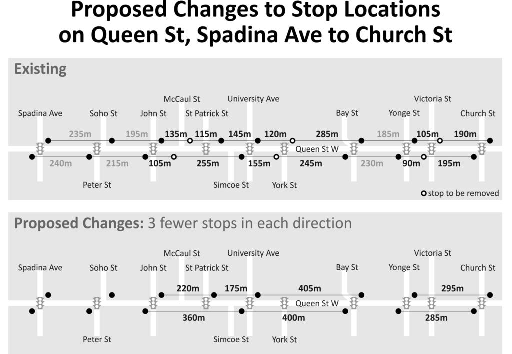
4 CUSTOMER JOURNEY TIMES: TRANSIT STOPS Page 4 regular streetcar stop. In support of the objectives of eliminating stops that are not at traffic signals and which are very close to other stops, these Sunday Stops will be removed. In order to provide a real-life illustration of what implementing the above-described principles and objectives would result in, the attached Exhibit 1 shows the existing and proposed locations of streetcar stops on Queen Street, between Church Street and Spadina Avenue -- an area whose close stop-spacing is the source of customer complaints. Under these new standards, the stops at Victoria Street, York Street, McCaul Avenue, and the westbound stop at Simcoe Street would all be removed. This would eliminate stops which are less than 200 metres away from adjacent stops, while keeping the maximum distance between stops at approximately 400 metres. In this example, there is a necessary exception: a new westbound stop would be installed at the signalized Queen Street/Patrick Street intersection, which is just in advance of the McCaul Street turn-back loop. This new westbound-only stop would provide an alternative to the oftenovercrowded Queen Street/University Avenue stop for passengers alighting streetcars which are turning back at McCaul Street. TTC staff will present to the Board, at the February 24, 2014 meeting, a follow-up report to document the implications for streetcar routes of the updated stop-location standards described in the current report. That report will also present staff s plan for consulting with affected Councillors prior to changing the location of stops. A further report, summarising changes to bus stop locations, will require more time to prepare because of the much-larger number of bus stops in the TTC system. That report will be submitted upon completion of the bus-stop review. JUSTIFICATION The Board should endorse the principles of locating transit stops at traffic signals and removing closely-spaced transit stops in order to improve the safety of customers when crossing to or from transit stops and to improve the operating speed, on-board travel experience, and travel time competitiveness of TTC services /80 Attachment: Exhibit 1 Proposed Changes to Stop Locations on Queen Street, Spadina Avenue to Church Street
5
TORONTO TRANSIT COMMISSION REPORT NO.
 Revised: March/13 TORONTO TRANSIT COMMISSION REPORT NO. MEETING DATE: May 28, 2014 SUBJECT: IMPROVING PEDESTRIAN SAFETY AND CUSTOMER JOURNEY TIMES: TRANSIT STOPS ACTION ITEM RECOMMENDATIONS It is recommended
Traffic Control Signals Review 4325 McCowan Road
 REPORT FOR ACTION Traffic Control Signals Review 4325 McCowan Road Date: March 15, 2018 To: Scarborough Community Council From: Director, Transportation Services, Scarborough District Wards: Ward 41 Scarborough
Transportation Impacts: Toronto York Spadina Subway Extension
 STAFF REPORT ACTION REQUIRED Transportation Impacts: Toronto York Spadina Subway Extension Date: June 6, 2011 To: From: Wards: Reference Number: North York Community Council Director, Transportation Services
Traffic Control Signals - Cosburn Avenue and Cedarvale Avenue
 REPORT FOR ACTION Traffic Control Signals - Cosburn Avenue and Cedarvale Avenue Date: April 24, 2017 To: Toronto and East York Community Council From: Acting Director, Transportation Services, Toronto
MEETING DATE: DECEMBER 9, SUBJECT: Use Of Cameras To Enforce Transit Lanes RECOMMENDATIONS. It is recommended that the Commission:
 MEETING DATE: DECEMBER 9, 2002 SUBJECT: Use Of Cameras To Enforce Transit Lanes RECOMMENDATIONS It is recommended that the Commission: 1. Receive this report for information, noting that; several major
Improving Cyclist Safety at the Dundas Street West and Sterling Road Intersection
 STAFF REPORT ACTION REQUIRED Improving Cyclist Safety at the Dundas Street West and Sterling Road Intersection Date: August 17, 2012 To: From: Wards: Reference Number: Public Works and Infrastructure Committee
Bicycle Traffic Control Signal - St. Clair Avenue West and Poplar Plains Road
 PW17.11 REPORT FOR ACTION Bicycle Traffic Control Signal - St. Clair Avenue West and Poplar Plains Road Date: November 4, 2016 To: Public Works and Infrastructure Committee From: Acting General Manager,
2. KING EDWARD AVENUE AND ST. PATRICK STREET - SAFETY IMPROVEMENT
 2. KING EDWARD AVENUE AND ST. PATRICK STREET - SAFETY IMPROVEMENT COMMITTEE RECOMMENDATION That Council approve the construction of the proposed modifications for the intersection of King Edward Avenue
CITY OF VAUGHAN EXTRACT FROM COUNCIL MEETING MINUTES OF OCTOBER 30, 2012
 CITY OF VAUGHAN EXTRACT FROM COUNCIL MEETING MINUTES OF OCTOBER 30, 2012 Item 31, Report No. 39, of the Committee of the Whole, which was adopted without amendment by the Council of the City of Vaughan
TORONTO TRANSIT COMMISSION REPORT NO.
 Form Revised: February 2005 TORONTO TRANSIT COMMISSION REPORT NO. MEETING DATE: February 18, 2009 SUBJECT: EXPRESS BUS CHANGES ACTION ITEM RECOMMENDATION It is recommended that the Commission forward this
Traffic Control Signals Review McCowan Road and Bridlegrove Drive
 REPORT FOR ACTION Traffic Control Signals Review McCowan Road and Bridlegrove Drive Date: September 21, 2016 To: Scarborough Community Council From: Director, Transportation Services, Scarborough District
Appendix 1 Transit Network Analysis
 Appendix 1 Transit Network Analysis APPENDIX 1 TRANSIT NETWORK ANALYSIS The purpose of this appendix is to provide an update on the transit network analysis as it pertains to: i. SmartTrack ii. Scarborough
Evaluation and Changes to Pedestrian Priority Phase Signal (Scramble Crossing) at Bay Street and Bloor Street
 at Bay Street and Bloor Street") PW2.2 STAFF REPORT ACTION REQUIRED Evaluation and Changes to Pedestrian Priority Phase Signal (Scramble Crossing) at Bay Street and Bloor Street Date: February 12, 2015 To: From: Public Works and Infrastructure
PW2.2 STAFF REPORT ACTION REQUIRED Evaluation and Changes to Pedestrian Priority Phase Signal (Scramble Crossing) at Bay Street and Bloor Street Date: February 12, 2015 To: From: Public Works and Infrastructure
Cutting Canada s Slowest Rush Hour with Public Transportation
 Cutting Canada s Slowest Rush Hour with Public Transportation Denny Yip September 30 th, 2011 1. Introduction Transportation is a key issue in Canada. In the province of Ontario, the Greater Toronto Area
Road Alterations - Wellington Street East, Church Street, and Front Street Intersection
 REPORT FOR ACTION Road Alterations - Wellington Street, Church Street, and Front Street Intersection Date: November 1, 2016 To: Toronto and York Community Council From: Director, Public Realm Section,
Toronto and East York Community Council. Director, Transportation Services, Toronto and East York District
 No Turn on Red Regulations STAFF REPORT ACTION REQUIRED Date: June 1, 2010 To: From: Toronto and East York Community Council Director, Transportation Services, Toronto and East York District Wards: Trinity
Construction Staging Area Vaughan Road
 REPORT FOR ACTION Construction Staging Area - 109 Vaughan Road Date: May 25, 2017 To: Toronto and East York Community Council From: Acting Director, Transportation Services, Toronto and East York District
2.2 TRANSIT VISION 2040 FROM VISION TO ACTION. Emphasize transit priority solutions STRATEGIC DIRECTION
 TRANSIT VISION 2040 FROM VISION TO ACTION TRANSIT VISION 2040 defines a future in which public transit maximizes its contribution to quality of life with benefits that support a vibrant and equitable society,
Dowling/Beaty Cycling Route
 Public Meeting #2 Dowling/Beaty Cycling Route May 17, 2017 6:00 p.m. 8:00 p.m. Parkdale Public Library - Auditorium 1303 Queen Street West How to Participate Share your questions, ideas and concerns We
Harbord Street and Hoskin Avenue Bicycle Lane Upgrades
 STAFF REPORT ACTION REQUIRED and Bicycle Lane Upgrades Date: April 22, 2014 To: From: Wards: Reference Number: Public Works and Infrastructure Committee General Manager, Transportation Services 19 and
4 DISRUPTION MANAGEMENT PLAN HIGHWAY 7 RAPIDWAY CONSTRUCTION BETWEEN BAYVIEW AVENUE AND WARDEN AVENUE TOWNS OF MARKHAM AND RICHMOND HILL
 4 DISRUPTION MANAGEMENT PLAN HIGHWAY 7 RAPIDWAY CONSTRUCTION BETWEEN BAYVIEW AVENUE AND WARDEN AVENUE TOWNS OF MARKHAM AND RICHMOND HILL The Transportation Services Committee recommends the adoption of
TRANSPORTATION IMPACT STUDY
 Dundas MEP Developments Inc. City of Toronto 219 and 231 Dundas Street East, Proposed Mixed-Use Development TRANSPORTATION IMPACT STUDY 9782/2 April 216 LEA Consulting Ltd. Consulting Engineers & Planners
APPENDIX 2 LAKESHORE ROAD TRANSPORTATION REVIEW STUDY EXECUTIVE SUMMARY
 APPENDIX 2 LAKESHORE ROAD TRANSPORTATION REVIEW STUDY EXECUTIVE SUMMARY Appendix 2 City of Mississauga Lakeshore Road FINAL REPORT Transportation Review Study December 2010 EXECUTIVE SUMMARY Study Purpose
Southwest Bus Rapid Transit (SW BRT) Functional Planning Study - Executive Summary January 19 LPT ATTACHMENT 2.
 Functional Planning Study - Executive Summary January 19 LPT ATTACHMENT 2.") Southwest Bus Rapid Transit (SW BRT) Functional Planning Study - Executive Summary 2011 January 19 1 of 19 Introduction This executive summary presents the results of the Southwest Bus Rapid Transit (SW
Southwest Bus Rapid Transit (SW BRT) Functional Planning Study - Executive Summary 2011 January 19 1 of 19 Introduction This executive summary presents the results of the Southwest Bus Rapid Transit (SW
Contents. Champaign-Urbana Mass Transit District Stop Placement Guidelines
 Contents Champaign-Urbana Mass Transit District Introduction... 1 Stop Spacing... 2 Rural... 2 Low Density Suburban... 2 General Urban... 2 Urban Core... 2 Operational Safety... 3 Stop Placement... 4 Nearside
Ridership Growth Strategy. Presentation to the board & beyond 1
 Ridership Growth Strategy Presentation to the board 2018 2022 & beyond 1 Objectives of the Ridership Growth Strategy 1 Retain 2 Increase 3 Attract current customers transit rides per current customer new
Pedestrian Crossing Protection Review - Howard Street
 REPORT FOR ACTION Pedestrian Crossing Protection Review - Howard Street Date: May 5, 2017 To: Toronto and East York Community Council From: Acting Director, Transportation Services, Toronto and East York
Richmond Street and Adelaide Street Cycle Tracks
 IE1.05 REPORT FOR ACTION Richmond and Cycle Tracks Date: January 3, 2019 To: Infrastructure and Environment Committee From: General Manager, Transportation Services Wards: 10 (Spadina-Fort York), 13 (Toronto
Submission to Metrolinx on Eglinton LRT - East End. Response to December 2012 Public Meeting
 Submission to Metrolinx on Eglinton LRT - East End Project Response to December 2012 Public Meeting Prepared by: Cycle Toronto, cycleto.ca Authors: John Taranu, Michael Black January 21, 2013 1 Introduction
Traffic Control Signals Cosburn Avenue and Todmorden Lane/ Private Access
 REPORT FOR ACTION Traffic Control Signals Cosburn Avenue and Todmorden Lane/ Private Access Date: May 25, 2017 To: Toronto and East York Community Council From: Acting Director, Transportation Services,
Integrated Corridor Approach to Urban Transport. O.P. Agarwal World Bank Presentation at CODATU XV Addis Ababa, 25 th October 2012
 Integrated Corridor Approach to Urban Transport O.P. Agarwal World Bank Presentation at CODATU XV Addis Ababa, 25 th October 2012 What is the Integrated Corridor Approach for Urban Transport Public? Why
Richmond-Adelaide Cycle Tracks
 Public Drop-In Event Richmond-Adelaide Cycle Tracks June 25, 2018 12:00 p.m. 3:00 p.m. 4:30 p.m. 7:30 p.m. Metro Hall, Rotunda 55 John Street 1 Purpose of Event In Scope Communicate an update about the
DON MILLS-SHEPPARD Mobility Hub Profile
 DON MILLS-SHEPPARD Mobility Hub Profile Dundas Don Mills-Sheppard West-Bloor Anchor Hub Gateway Hub N MOBILITY HUBS: Places of connectivity between regional and rapid transit services, where different
NORTH YORK CENTRE Mobility Hub Profile
 Mobility Hub Profile Dundas North York West-Bloor Centre Anchor Hub Gateway Hub N MOBILITY HUBS: Places of connectivity between regional and rapid transit services, where different modes of transportation
Woodward Hill Elementary School School Safety and Operation Review
 Address: 6082-142 nd Street Surrey, BC, V3X 1C1 Site Visit: March 7, 2011 Principal Anne Mackie Report Date: November 25, 2011 Phone: (604) 594-2408 Email: Mackie_A@sd36.bc.ca The following report is one
As the Toronto Transit Commission (TTC) operates a transit service on Avenue Road, City Council approval of this report is required.
 operates a transit service on Avenue Road, City Council approval of this report is required.") REPORT FOR ACTION Corridor Safety Review - Avenue Road Date: September 27, 2017 To: Toronto and East York Community Council From: Acting Director, Transportation Services, Toronto and East York District
REPORT FOR ACTION Corridor Safety Review - Avenue Road Date: September 27, 2017 To: Toronto and East York Community Council From: Acting Director, Transportation Services, Toronto and East York District
Transportation Assessment
 Transportation Assessment Midtown Open House February 10, 2018 Overview Midtown in Focus Overview & Purpose of Today Transportation Assessment overview Summary of Transportation work to date Review & Analysis
June 29, Dear Mr. Walter:
 From: CountyBoard@arlingtonva.us To: chickandsandy@msn.com Subject: County Board Response Regarding the Arlington Ridge Road Improvement Project (Intranet Quorum IMA00252707) Date: Wed, 29 Jun 2011 08:09:53-0400
DON MILLS-EGLINTON Mobility Hub Profile
 Mobility Hub Profile Dundas Don Mills-Eglinton West-Bloor Anchor Hub Gateway Hub N MOBILITY HUBS: Places of connectivity between regional and rapid transit services, where different modes of transportation
CITY OF VAUGHAN EXTRACT FROM COUNCIL MEETING MINUTES OF NOVEMBER 15, 2016
 CITY OF VAUGHAN EXTRACT FROM COUNCIL MEETING MINUTES OF NOVEMBER 15, 2016 Item 6, Report No. 38, of the Committee of the Whole, which was adopted without amendment by the Council of the City of Vaughan
5 Transit & Traffic. Overview
 5 Transit & Traffic Overview Montgomery Place s roadways and overall traffic circulation are unique in the city due to the narrow streets and avenues with boulevards; however, no sidewalks or curbs in
WELCOME PETTIT AVENUE SPEED CONTROL REVIEW NIEGHBOURHOOD OPEN HOUSE. City of Niagara Falls Transportation Services
 WELCOME PETTIT AVENUE SPEED CONTROL REVIEW NIEGHBOURHOOD OPEN HOUSE City of Niagara Falls Transportation Services NEIGHBOURHOOD TRAFFIC REVIEW OBJECTIVES A Neighbourhood Traffic Review should be undertaken
KING STREET TRANSIT PILOT
 STREET TRANSIT PILOT Update toronto.ca/kingstreetpilot #kingstreetpilot HIGHLIGHTS PREVIOUS HIGHLIGHTS TRANSIT RELIABILITY TRANSIT TRAVEL TIMES 85% of streetcars arriving within 4 minutes westbound during
The following notes describe comments received that were written/drawn on maps by workshop participants.
 Stakeholder Workshop Additional Feedback Received Maps and Comment Forms October 5, 2016 The following notes describe comments received that were written/drawn on maps by workshop participants. MAP 1 MAP
Board Strategy Day. January 25, 2018
 Board Strategy Day January 25, 2018 Corporate Plan 2018-2022 & beyond Presentation to the board 2018 2022 & beyond 2 Building on the last five-year plan 2013 2017 21% reduction in subway delay minutes
10.0 CURB EXTENSIONS GUIDELINE
 10.0 CURB EXTENSIONS GUIDELINE Road Engineering Design Guidelines Version 1.0 March 2017 City of Toronto, Transportation Services City of Toronto Page 0 Background In early 2014, Transportation Services
DUNDAS WEST-BLOOR Mobility Hub Profile
 Mobility Hub Profile Dundas West-Bloor Anchor Hub Gateway Hub N MOBILITY HUBS: Places of connectivity between regional and rapid transit services, where different modes of transportation come together
Public Information Centre
 WELCOME Public Information Centre Father Tobin Road Lougheed Middle School - Library Wednesday November 7, 2012 7:00 p.m.to 9:00 p.m. Please sign in Neighbourhood Traffic Calming Guide Background The City
REPORT. Engineering and Construction Department
 REPORT COMMUNITY SERVICES COMMITTEE MEETING DATE: JUNE 11, 2013 FROM: Engineering and Construction Department DATE: May 24, 2013 SUBJECT: Great Lakes Boulevard Mini Roundabout LOCATION: Great Lakes Boulevard
Transportation & Land Use. Workshop: March 6, 2013
 Marpole Community Plan Transportation & Land Use Workshop: March 6, 2013 Overview 1 Community Plan 2 Transportation 2040 & Community Plans 3 4 Overview 1 Community Plan 2 Transportation 2040 & Community
Public Event 1 Community Workshops
 Public Event 1 Community Workshops Nov. 24 & Dec. 3, 2016 Welcome Workshop Purpose We re looking to you for ideas and insights to help guide future transportation infrastructure planning in the Park Lawn
BUS RAPID TRANSIT. A Canadian Perspective. McCormick Rankin International. John Bonsall P.Eng
 BUS RAPID TRANSIT A Canadian Perspective Why choose BRT? Because it is a practical and cost effective rapid transit solution for the most common types of land use in urban Canada Operating experience shows
Chapter 7. Transportation. Transportation Road Network Plan Transit Cyclists Pedestrians Multi-Use and Equestrian Trails
 Chapter 7 Transportation Transportation Road Network Plan Transit Cyclists Pedestrians Multi-Use and Equestrian Trails 7.1 TRANSPORTATION BACKGROUND The District of Maple Ridge faces a number of unique
Traffic Calming St. Clarens Avenue between Brandon Avenue and Davenport Road
 STAFF REPT ACTION REQUIRED Traffic Calming St. Clarens Avenue between Brandon Avenue and Davenport Road Date: February 2, 2012 To: From: Wards: Reference Number: Etobicoke York Community Council Acting
Caltrans Sloat Boulevard Pedestrian Safety Project Response to Community Questions, Comments & Concerns
 Caltrans Sloat Boulevard Pedestrian Safety Project Response to Community Questions, Comments & Concerns Revised: May 10, 2016 The California Department of Transportation (Caltrans) is planning various
Building a Toronto that Moves
 Building a Toronto that Moves Image courtesy of the City of Toronto Setting Election Priorities for Walking, Cycling & Public Transit Toronto is a fast-paced, dynamic city. It s a city that moves except
TORONTO TRANSIT COMMISSION REPORT NO. MEETING DATE: May 28, 2009 SUBJECT: ACTION ITEM
 Form Revised: September 1999 TORONTO TRANSIT COMMISSION REPORT NO. MEETING DATE: May 28, 2009 SUBJECT: EAST BAYFRONT TRANSIT ENVIRONMENTAL ASSESSMENT: STREETCAR SERVICE ON QUEENS QUAY EAST BETWEEN YONGE
Traffic Management and Mitigation Study in the Leslieville Community Transportation Services Division & IBI Group IBI GROUP
 Traffic Management and Mitigation Study in the Leslieville Community Transportation Services Division & IBI Group IBI GROUP July 18, 2018 Study Background and Objectives Background - Many development projects
CITY OF OTTAWA ROADWAY MODIFICATION APPROVAL UNDER DELEGATED AUTHORITY
 RMA-2015-ATM-038 CITY OF OTTAWA ROADWAY MODIFICATION APPROVAL UNDER DELEGATED AUTHORITY DATE: April 22, 2015 SUBJECT Approval of Roadway Modifications Recommended through an Area Traffic Management Study
Proposed. City of Grand Junction Complete Streets Policy. Exhibit 10
 Proposed City of Grand Junction Complete Streets Policy Exhibit 10 1 City of Grand Junction Complete Streets Policy Vision: The Complete Streets Vision is to develop a safe, efficient, and reliable travel
Having held a public hearing, that Council approve:
 3. MODIFICATIONS TO MERIVALE ROAD FROM FALLOWFIELD ROAD TO OLD HIGHWAY 16 TO ACCOMMODATE THE GROWTH WITHIN THE SOUTH MERIVALE BUSINESS PARK - PUBLIC HEARING COMMITTEE RECOMMENDATIONS Having held a public
Downtown Transportation Operations Study
 Attachment 2 - Project s Project 1 Downtown Transportation Operations Project Implementation Team Establish a Downtown Transportation Operations Project Implementation Committee and Action Team to develop,
122 Avenue: 107 Street to Fort Road
 : 107 Street to Fort Road November 24, 2015 4:30 8:00 p.m. Meeting Purpose Summarize project work completed to date Share results of public input from Phase 1 Share the draft concept plan and proposed
7 June 2018 OUR REF:
 7 June 2018 OUR REF: 476729-01000 Mirtillo Estates Inc. 1681 Langstaff Road, Unit 1 Vaughan, Ontario, L4K 5T3 Attention: Joran Weiner Vice-President Dear Mr. Weiner: Re: Mirtillo Estates Sales Office Transportation
Downtown BRT Corridor Alternatives Review: 1 st, 2 nd, 3 rd and 4 th Avenue. Bus Rapid and Conventional Transit Planning and Design Services
 Downtown BRT Corridor Alternatives Review: 1 st, 2 nd, 3 rd and 4 th Avenue Bus Rapid and Conventional Transit Planning and Design Services City of Saskatoon February 2018 Project Team HDR Corporation
EMPHASIS AREA 1: PEDESTRIANS
 EMPHASIS AREA 1: PEDESTRIANS A pedestrian is seriously injured or killed every 3 days on Toronto s roads. Pedestrian collisions involve any person that is not riding in a vehicle or on a bicycle. 26% OF
Appendix A. Road Classification Review of Outstanding Issues and Proposed Classifications (All Wards) Staff Report Road Classification System
 Staff Report Road Classification System") Appendix A Road Classification Review of Outstanding Issues and Proposed Classifications (All Wards) Staff Report 2000 A.1 of A.10 A.2 of A.10 STAFF REPORT January 26, 2000 To: From: Works Committee Barry
Appendix A Road Classification Review of Outstanding Issues and Proposed Classifications (All Wards) Staff Report 2000 A.1 of A.10 A.2 of A.10 STAFF REPORT January 26, 2000 To: From: Works Committee Barry
Pedestrian Crossing Guidelines 2016
 Pedestrian Crossing Guidelines 2016 Engineering Services 1.0 Introduction and Background The City of Kingston s first Pedestrian Crossing Guidelines were approved by Council in 2008 in order to provide
Cabinet Member for Highways & Streetscene. Highway Infrastructure Manager
 LONDON BOROUGH OF RICHMOND UPON THAMES DATE: AUGUST 2015 DECISION MAKER: LEAD OFFICER: SUBJECT: WARDS: Cabinet Member for Highways & Streetscene Highway Infrastructure Manager PROPOSED CYCLING IMPROVEMENTS
M14A/D Select Bus Service
 M14A/D Select Bus Service Manhattan Community Board 6: April 1, 2019 New York City Transit 2 Background M14 Select Bus Service M14 was identified as a critical future SBS corridor in past BRT studies as
Public Works and Infrastructure Committee. General Manager, Transportation Services
 STAFF REPORT ACTION REQUIRED Extending the Bay Street Bicycle Lanes Date: May 16, 2013 To: From: Public Works and Infrastructure Committee General Manager, Transportation Services Wards: Toronto Centre
INITIAL BUSINESS CASE REPORT
 DURHAM-SCARBOROUGH BUS RAPID TRANSIT STUDY INITIAL BUSINESS CASE REPORT DURHAM Prepared for Metrolinx by IBI Group Spring 2018 Table of Contents Executive Summary... ES-1 Introduction... ES-1 Study Overview...
Cycling Network Plan Implementation in Thorncliffe Park and Flemingdon Park
 PW28.13 REPORT FOR ACTION Cycling Network Plan Implementation in Thorncliffe Park and Flemingdon Park Date: March 26, 2018 To: Public Works and Infrastructure Committee From: General Manager, Transportation
MEMORANDUM. Charlotte Fleetwood, Transportation Planner
 MEMORANDUM Date: Updated August 22, 2017 To: Organization: Charlotte Fleetwood, Transportation Planner Boston Transportation Department From: Jason DeGray, P.E., PTOE, Regional Director of Engineering
2.0 LANE WIDTHS GUIDELINE
 2.0 LANE WIDTHS GUIDELINE Road Engineering Design Guidelines Version 2.0.1 May 2018 City of Toronto, Transportation Services City of Toronto Page 0 Background In early 2014, Transportation Services initiated
Governance and Priorities Committee Report For the July 2, 2015 Meeting
 CITY OF VICTORIA For the July 2, 2015 Meeting To: Governance and Priorities Committee Date: From: Subject: Brad Dellebuur, A/Assistant Director, Transportation and Parking Services Executive Summary The
Operational Comparison of Transit Signal Priority Strategies
 Operational Comparison of Transit Signal Priority Strategies Revision Submitted on: November, 0 Author: Adriana Rodriguez, E.I Assistant Engineer Parsons Brinckerhoff 0 South Orange Avenue, Suite 00 Orlando,
Rank #1 Highest Priority Intersection
 Rank #1 Highest Priority Intersection Attachment 3: Proposed Interventions Pedestrian Safety City of Toronto s 10 Priority Intersections Sheppard Avenue East and Ambrose Road/Provost Drive Located in the
Corporate. Report COUNCIL DATE: May 25, 1998 NO: R1500 REGULAR COUNCIL. TO: Mayor & Council DATE: April 27, 1998
 R1500 : Traffic Safety at 25 Avenue and 128 Street Intersection Corporate NO: R1500 Report COUNCIL DATE: May 25, 1998 REGULAR COUNCIL TO: Mayor & Council DATE: April 27, 1998 FROM: General Manager, Engineering
TCAT 2006 Platform Review February 16, 2010
 1. Add 285 kilometers to the Bikeway Network by supporting the budgets outlined below: Transportation Services Year Platform Completed 2007 35 km $6.00 million $3.00 million While increasing substantially
Roadways. Roadways III.
 Introduction 97 Roadway Design Principles 98 Safe Speeds 99 Optimizing of Street Space 00 Minimum Lane Widths in the City of Boston 02 Design Features that Reduce Operating Speeds 05 Travel Lanes Transit
CURBSIDE ACTIVITY DESIGN
 5 CURBSIDE ACTIVITY DESIGN This chapter provides design guidance for separated bike lanes adjacent to curbside activities including parking, loading and bus stops. Typical configurations are presented
TRANSIT SIGNAL PRIORITY The Toronto Experience
 TRANSIT SIGNAL PRIORITY The Toronto Experience July 27, 2004 July 27, 2004 1 Warning This presentation contains graphic images depicting serious violations to the coordination of traffic signals and may
Markham Sports, Entertainment and Cultural Centre Transportation Overview
 Markham Sports, Entertainment and Cultural Centre Transportation Overview ARENA LOCATION 2 3 TRANSPORTATION VISION IN MARKHAM On April 12, 2011, Markham Council adopted a long-term Transportation Vision
Traffic Calming Rosemount Avenue, between Ralph Street and Queenslea Avenue
 STAFF REPT ACTION REQUIRED Traffic Calming Rosemount Avenue, between Ralph Street and Queenslea Avenue Date: April 20, 2016 To: From: Wards: Report Number: Etobicoke York Community Council Director, Transportation
Appendix B Workshop Materials
 Appendix B Workshop Materials Public Event 1 Community Workshops Nov. 24 & Dec. 3, 2016 Welcome Workshop Purpose We re looking to you for ideas and insights to help guide future transportation infrastructure
Creating walkable, bikeable and transit-supportive communities in Halton
 Creating walkable, bikeable and transit-supportive communities in Halton By presenting current research and best practices, the information in this paper is meant to support and broaden discussion on how
Welcome. The Brooklin Secondary Plan and Transportation Master Plan are collectively referred to as the Brooklin Study.
 Welcome The Town of Whitby is undertaking a study to prepare a Secondary Plan and Transportation Master Plan to guide and manage growth in the Brooklin area. The Brooklin Secondary Plan and Transportation
David Jickling, Public Transportation Director Regional Transportation Commission, Washoe County
 David Jickling, Public Transportation Director Regional Transportation Commission, Washoe County Virginia Street Resort corridor connecting University of Nevada, Reno Downtown Truckee River Strip Casinos
SETTINGS AND OPPORTUNITIES MOBILITY & ACCESS
 7 mobility & access how do people use el camino what is it like to drive on el camino/to park along el camino what is the pedestrian experience like what is the role of transit along the corridor what
INTRODUCTION DISCUSSION
 INTRODUCTION A study released by the Toronto Board of Trade reports that Toronto s traffic congestion has grown into a serious and costly problem. It states that Toronto commuters spend about 80 minutes
Traffic Congestion Management and Traffic Signal Coordination
 STAFF REPORT ACTION REQUIRED Traffic Congestion Management and Traffic Signal Coordination Date: April 30, 2013 To: From: Wards: Reference Number: Public Works and Infrastructure Committee General Manager,
WELCOME! Please complete a comment sheet as we value your feedback. 4 pm to 8 pm. September 15, Hosted by: AECOM on behalf of City of Calgary
 WELCOME! Thank you for attending our open house. There will be no formal presentation today so please take the time to read the boards. If you have any questions, please do not hesitate to approach one
TRAFFIC ACTION PLAN. North Central Neighborhood CITY OF SAN MATEO
 TRAFFIC ACTION PLAN North Central Neighborhood CITY OF SAN MATEO Draft February 2017 Table of Contents Introduction... 1 The Traffic Forum Process... 4 Neighborhood Traffic Issues... 6 Neighborhood Recommendations
Exhibit 1 PLANNING COMMISSION AGENDA ITEM
 Exhibit 1 PLANNING COMMISSION AGENDA ITEM Project Name: Grand Junction Circulation Plan Grand Junction Complete Streets Policy Applicant: City of Grand Junction Representative: David Thornton Address:
Richmond Adelaide Cycle Track Planning and Design Study Pilot Project
 STAFF REPORT ACTION REQUIRED Cycle Track Planning and Design Study Pilot Project Date: April 22, 2014 To: From: Wards: Reference Number: Public Works and Infrastructure Committee General Manager, Transportation
7/23/2017 VIA . Michael Hanebutt City of Sacramento Community Development Department 300 Richards Boulevard, 3 rd Floor Sacramento, CA 95811
 7/23/2017 VIA EMAIL Michael Hanebutt City of Sacramento Community Development Department 300 Richards Boulevard, 3 rd Floor Sacramento, CA 95811 RE: 65 th Street Apartments (DR17-220) Dear Mr. Hanebutt:
Providence Downtown Transit Connector STAKEHOLDER MEETING #2. Stakeholder Meeting #1 October 24, 2016
 Providence Downtown Transit Connector STAKEHOLDER MEETING #2 Stakeholder Meeting #1 October 24, 2016 February 2017 1 AGENDA 1 DTC Goals and Expectations 2 Street Design Concepts 3 Potential Benefits and
WELCOME Public Information Centre
 WELCOME Public Information Centre Fernforest Drive Brampton Soccer Centre Community Room #2 Tuesday January 19, 2016 6:30 p.m.to 9:00 p.m. Please sign in Neighbourhood Traffic Calming Guide Background
ECONOMY PEOPLE ENVIRONMENT
 Report Back on Local Transit Improvements May 29, 2013 ECONOMY PEOPLE ENVIRONMENT Intro Council Requested Report Back Topics Progress on Planning for Broadway Subway False Creek Bridges Local Transit Improvements