Lake Whitney Elementary School
|
|
|
- Rodney Sims
- 5 years ago
- Views:
Transcription

1 Lake Whitney Elementary School
2 SCHOOL ROUTE PLAN For LAKE WHITNEY ELEMENTARY SCHOOL LOCATION 18 ORANGE COUNTY Prepared for: ORANGE COUNTY SCHOOL ASSESSMENT PROGRAM ORANGE COUNTY PUBLIC WORKS Traffic Engineering Division 4200 South John Young Parkway Orlando, Florida Contract No.: Y4-903B HNTB No Prepared by: Lake Mary, Florida August 14, 2006 Professional Engineer: Josiah Banet, P.E. P.E. No
3 School Route Plan-Lake Whitney Elementary School TABLE OF CONTENTS EXECUTIVE SUMMARY INTRODUCTION EXISTING CONDITIONS QUALITATIVE ASSESSMENT RECOMMENDATIONS APPENDIX FIGURES, EXHIBITS, and TABLES FIGURES Figure 1 - Project Location Map... 4 Figure 2 School Boundary Map...9 Figure 3 School Route Plan Map Figure 4 Condition Diagram: North School Entrance and Windermere Road Figure 5 Condition Diagram: Roberson Road at Windermere Road Figure 6 - Conceptual Improvement Diagram EXHIBITS Exhibit 1 - Windermere Road at Windermere Crossing Circle/School Entrance Exhibit 2 - Windermere Road at Windermere Crossing Circle/School Entrance Exhibit 3 - Roberson Road at Windermere Road Exhibit 4 - Roberson Road at Windermere Road TABLES Table 1 - Field Inventory...5 Table 2 - Summaries of Vehicular Volumes...6 Table 3 - Summaries of Pedestrian & Bicycle Volumes...7
4 School Route Plan- Lake Whitney Elementary School 1 EXECUTIVE SUMMARY HNTB Corporation was retained by Orange County Public Works to conduct a School Route Plan Study for Lake Whitney Elementary School located at 1351 Windermere Road, Orange County, Florida. This study is being performed as a part of the County s School Assessment Program to identify safe routes for children to walk and bicycle to school. Based on the results of the analysis, field observations, and engineering judgment, the following recommendations and conclusions were developed: 1. Pedestrian bicycle access to the school is safe and efficient. 2. A sidewalk is recommended along the western side of Windermere Road south of the school to allow pedestrians to walk to the school crossing at the north school entrance. 3. A school crossing advance warning sign with an AHEAD sign is recommended along northbound Windermere Road to the south of the school crossing at the north school entrance. This sign will serve to remind northbound drivers that although they have passed the south school entrance, the school crosswalk is ahead at the north school entrance. 4. Remove the old school crosswalk warning signs at the school crossing located at the north school entrance and replace with updated school crossing warning signs that include an arrow pointing to the crosswalk location. 5. Crosswalks need to be repainted at the Roberson Road crossing location at the Wesmere and Belmere subdivision entrances. 6. A crosswalk needs to be added at the Roberson Road entrance of the Belmere subdivision to connect the sidewalk to the east and west of the entrance. 7. A school crossing sign with an arrow is recommended at the Roberson Road exit from the Wesmere subdivision to alert residents of crosswalk outside the neighborhood gate. 8. The school crossing sign panel needs to be replaced on the existing sign post at the school crossing location on Roberson Road. 9. The speed indicator that accompanies the 20 mph school zone sign with flashing beacons along northbound Windermere Road approach is stuck on 1 MPH, and needs to be reset. 10. The school crossing sign panel needs to be replaced on the existing sign posts on Windermere Road at Brookestone subdivision entrance. 11. Add a Signal Ahead sign on southbound Windermere Road before sharp curve that is upstream of Roberson Road intersection. 12. Consideration should be given to reducing the speed limit on Roberson Road between Windermere Road and Maguire Road to be consistent with the surrounding roadways. 13. Modifications to the signal timing at Roberson Road and Windermere Road is recommended during school hours to incorporate a split phase allowing WB Roberson
5 School Route Plan- Lake Whitney Elementary School 2 Road left turning traffic to clear the intersection during a signal cycle. This movement queues up during the pick up and drop off school periods. A left turn lane or left turn signal at the Windermere Road/Roberson Road signal should also be considered. 14. A right turn lane is recommended on Northbound Windermere Road to accommodate the carpool traffic at the south school entrance. 15. Sidewalk should be provided on school property to connect to George Bailey Park sidewalk to the sidewalks on the school grounds.
6 School Route Plan- Lake Whitney Elementary School 3 1. INTRODUCTION HNTB Corporation was retained by Orange County Public Works to conduct a School Route Plan Study for Lake Whitney Elementary School located at 1351 Windermere Road, Orange County, Florida. The purpose of this study is to identify safe routes for children to walk and bicycle to school. The analysis methods used in conducting this study are consistent with those set forth in the Manual on Uniform Traffic Control Devices (MUTCD 2003), the Manual on Uniform Traffic Studies (MUTS), and Orange County guidelines and procedures.

7 School Route Plan- Lake Whitney Elementary School 4 Figure 1 - Project Location Map
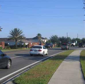
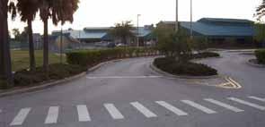
8 School Route Plan- Lake Whitney Elementary School 5 2. EXISTING CONDITIONS Lake Whitney Elementary School is located in Western Orange County on Windermere Road approximately 0.25 miles south of Roberson Road. Significant features for the study location are summarized below: Feature Table 1 - Field Inventory Description School Name Lake Whitney Elementary School Address 1351 Windermere Road Orlando, FL School Hours 8:45 AM- 3:00 PM (2:00 PM Wednesday) Student Enrollment 1,040 Primary Roadway Access Roberson Road Two-lane primary access road east of Windermere Road. Becomes Stoneybrook West Parkway, a four lane road, west of Windermere Road. Posted speed limit: 45 mph east of Windermere Road; 35 mph west of Windermere Road Sidewalks: Both sides of roadway west of Windermere, on the south of the roadway east of Windermere Road. Intermittent sidewalk on north side of roadway to the east of Windermere Road. No street lighting Windermere Road Two lane arterial with left turn lanes at the intersection Posted speed limit: 35 mph Sidewalks: Both sides of roadway north of the school entrance, east side only south of the school entrance No street lighting Pedestrian and Bicycle Access to Sidewalk to the north of the school entrance, and south of the school School at the parent pick up loop. Sidewalk leading from the adjacent park. Carpool Access to School Southern driveway along Windermere Road Bus Access Northern driveway along Windermere Road Guarded School Crossings Windermere Road at the Bus Loop entrance (Northernmost East Driveway) School entrance is stop controlled. School crossing warning signs on all approaches School zone digital speed limit signs with flashers on Windermere Road Crossing guard provided during school times Roberson Road at Wesmere and Belmere entrances Neighorhood entrances are stop controlled. School crossing warning signs on all approaches School zone digital speed limit signs with flashers on Windermere Road Crossing guard provided during school times Other Facilities Sidewalks are provided along most roadways in adjacent neighborhoods within the walk zone. Reduced Speed School Zones On Windermere Road south of the school entrance to south of Roberson Road On Roberson Road east of Windermere Road and west of Maguire Road
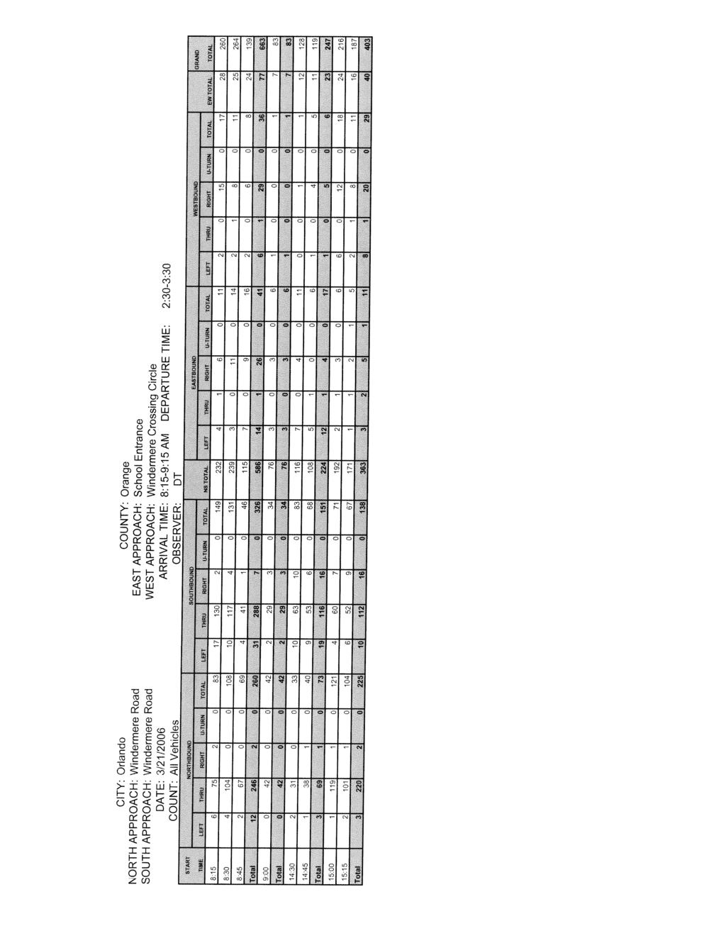
9 School Route Plan- Lake Whitney Elementary School 6 Vehicular, Pedestrian, and Bicycle Volumes Two-hour turning movement counts were conducted at the intersection of Roberson Road and Windermere Road and at Windermere Road and Lake Whitney Elementary School Entrance. The counts were conducted from 8:15 to 9:15 AM and 2:30 to 3:30 PM to coincide with the morning arrival time and afternoon departure time of students at the school. Pedestrian, bicycle, automobile, and bus traffic were recorded separately for this count. The following tables summarize the results of these counts: Table 2 - Summaries of Vehicular Volumes Approaches Windermere Road at Roberson Road Windermere Road Roberson Road Direction Northbound Southbound Eastbound Westbound Movement L T R TOT L T R TOT L T R TOT L T R TOT Morning Arrival: 815 to 915 Vehicles Busses Total Afternoon Departure: 1330 to 1430 Vehicles Busses Total Approaches Windermere Road at School Entrance Windermere Road School Entrance Direction Northbound Southbound Eastbound Westbound Movement L T R TOT L T R TOT L T R TOT L T R TOT Morning Arrival: 815 to 915 Vehicles Busses Total Afternoon Departure: 1430 to 1530 Vehicles Busses Total
10 School Route Plan- Lake Whitney Elementary School 7 Table 3 - Summaries of Pedestrian & Bicycle Volumes Roberson Road at Windermere Road Total 8:15 8:30 8:45 9:00 Total 1:30 1:45 2:00 2:15 AM PM AM 0 Windermere Road AM Total Total PM 0 Total AM 0 8: : : : : : : : AM PM Total Stoneybrook West Parkway Total AM PM : : : : : : : : Total PM 3 Total PM 0 Windermere Road Total 8:15 8:30 8:45 9:00 Total 1:30 1:45 2:00 2:15 AM PM Total AM PM 1 Roberson Road Windermere Road at Lake Whitney School Entrance Total 8:15 8:30 8:45 9:00 Total 2:30 2:45 3:00 3:15 AM PM AM 107 Windermere Road AM Total Total PM 21 Total AM 3 8: : : : Windermere Crossing Circle 8: : : : AM PM Total 0 0 Total AM PM : : : : : : : : Total PM 0 Total PM 1 Windermere Road Total 8:15 8:30 8:45 9:00 Total 2:30 2:45 3:00 3:15 AM PM Total AM PM 0 School Entrance
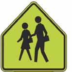
11 School Route Plan- Lake Whitney Elementary School 8 3. QUALITATIVE ASSESSMENT Lake Whitney Elementary School is located on Windermere Road, approximately 0.25 miles south of Roberson Road. The school serves children who live in adjacent neighborhoods along Windermere Road and as well as children who live in neighborhoods adjacent to Roberson Road. The entire school zone does not fall within the two mile walk zone of the school. Orange County currently provides bus service for children that live outside the two mile walk zone of Lake Whitney Elementary. Figure 2 illustrates the school zone boundaries, two-mile walk radius, and existing bus stops for Lake Whitney Elementary School. Bus service is currently provided to neighborhoods along the east side of CR 535 and to the east of Maguire Road within the school zone. Figures 3 and 4 are School Route Plan maps of the area within the two-mile walk limit where school bus service is not provided. This area is the focus of the qualitative assessment. The school route plan area was reviewed by a registered professional engineer to evaluate vehicle, pedestrian, and bicycle flow patterns to determine what improvements are necessary, if any, to improve the safety and efficiency of the children traveling to and from school. Sidewalks A majority of the children that walk or bicycle to the school live in the adjacent subdivisions of Windermere Crossing, Wesmere, Belmere, and the Reserve at Belmere. Sidewalks are provided within these subdivisions and along the walking routes to the school. It should be noted that while sidewalks are provided along Windermere Road and Roberson Road, at times sidewalks are only available on one side of the roadway. The sidewalk is discontinuous along the western side of Windermere Road across from the school and along the north side of Roberson Road between Windermere Road and Maguire Road. On one instance, a student was observed wheeling his backpack in the grass along Windermere Road because of the lack of sidewalk on the west side of the road. It is recommended that the sidewalk along the west side of Windermere Road in front of the school be extended to the south. School Crossings Along the walking route for students to Lake Whitney Elementary School, there are two locations where crossing guards are present. These locations were: On Windermere Road at the north school entrance On Roberson Road at the entrance to Wesmere and Belmere subdivisions The intersection of Windermere Road at the north school entrance was observed during the morning and afternoon school hours. The crossing guard mainly oversees pedestrian and bike crossings to and from the school across Windermere Road. This is the main pedestrian entrance to Lake Whitney Elementary School. Many of these pedestrians are from the Windermere Crossing subdivision, which has an entrance directly across from the school at this location. Red striping is provided on both sides of Windermere Road for the designation of a safe standing distance from the vehicular traffic. The school crosswalk warning signs at this crossing are the older signs, which display the crosswalk on them.

12 9 N Lake Whitney Elementary School 2 Mile Walk Zone Legend School Zone Boundary School School Bus Stop Traffic Signal Figure 2 School Boundary Map
13
14
15 School Route Plan- Lake Whitney Elementary School 12 The main safety concerns at this location include the speed of travel of passing vehicles, which typically is above the posted school zone speed limit of 20 mph, and the occasional vehicle not stopping for the crossing guard. While 20 mph school zone flashers are present to the north and south of the crossing, the flashers south of the crossing are south of the southern school entrance, which is designated for car riders. Therefore, once northbound traffic passes the southern school entrance, drivers tend to think that the school zone is over, and some are somewhat surprised as they arrive at the pedestrian crossing at the northern school entrance. Figure 4 illustrates the conditions at north school entrance on Windermere Road. A school crosswalk advance warning sign with an AHEAD sign is recommended to be placed along northbound Windermere Road south of this pedestrian crossing to remind drivers that this is the main crossing for students across Windermere Road. Recommend replacing the old school crosswalk warning signs that contain the crosswalk with new school crosswalk warning signs that include an arrow pointing to the crosswalk location. A second crossing guard is stationed along Roberson Road at the entrance to the Belmere and Wesmere subdivisions. The students and parents crossing Roberson Road at this location are primarily from the Wesmere subdivision, located on the north side of Roberson Road. The speed of passing vehicles on Roberson Road is the main concern at this crossing. A DARE officer routinely enforces the school zone speed limits through this section of Roberson Road which keeps speeds in check during those periods. However, in his absence, vehicular speeds increase. The crosswalks at this school crossing are beginning to look worn and faded. There is also a need for a crosswalk at the entrance to Belmere to connect the sidewalk on both sides of the entrance. A school crosswalk sign with an arrow is needed at the exit from Wesmere neighborhood to inform the residents leaving the neighborhood that a school crosswalk exists. The school crossing sign panel was missing from the sign post on eastbound Roberson Road. Crosswalks at this school crossing need to be repainted and A crosswalk is recommended at the entrance to Belmere. A school crossing sign with an arrow is recommended at the exit from the Wesmere neighborhood. Replace the missing pedestrian sign panel along eastbound Roberson Road at the crosswalk in front of the Belmere and Wesmere entrances. Traffic Conditions Traffic along Windermere Road and Roberson Road typically operates at free flow conditions. Heavier traffic occurs during school drop off and pick up times. The main traffic concerns are related to vehicular speeds through the school zones during school drop off and pick up times. Along Windermere Road there are 20 mph school zone signs with flashing beacons and speed indicators to the north and south of the school entrances.
16
17 School Route Plan- Lake Whitney Elementary School 14 The speed indicator associated with the 20 mph school flasher along northbound Windermere Road south of the school is currently broken, showing a constant 1 mph speed. On Windermere Road north of Roberson Road, pedestrian crossing panels are missing at the entrance of Brookestone subdivision. There is a sharp curve along Windermere Road just to the north of the signalized intersection with Roberson Road. This curve hinders sight distance along the southbound approach to this signalized intersection, which includes pedestrian crossings. The posted speed limit along Roberson Road of 45 mph is not consistent with the surrounding roadways. For example, to the west of the Roberson Road intersection with Windermere Road the speed limit drops to 35 mph. The speed limit along Windemere Road is 35 mph. On Roberson Road there are 20 mph school zone signs with flashing beacons and speed indicators to the east and west of the pedestrian crossing at Wesmere and Belmere neighborhood entrances. This school crossing speed limit of 20 mph is significantly lower than the posted normal speed limit of 45 mph, making it difficult for many drivers to reduce their speeds appropriately. Reset the 20 mph school zone sign with flashing beacons along northbound Windermere Road, as the speed indicator is set to 1 mph continuously. Replace pedestrian crossing panels at crossing across Windermere Road at the Brookestone subdivision entrance. Add a signal ahead sign on southbound Windermere Road before the curve to give advanced warning that a signalized intersection immediately follows the curve. Consider reducing the speed limit along Roberson Road between Windermere Road and Maguire Road to be in line with the surrounding roadways. Traffic counts were taken at the intersection of Windermere Road at Roberson Road during the morning and afternoon school hours. It is a signalized intersection with shared right-thruleft lanes on all approaches. The following observations were made: The traffic signal operates in actuated mode throughout the day. With the exception of the heavy westbound left turn movement during school times, the intersection operates efficiently with minimal queuing or delay. During school arrival and departure periods, a queue develops on the westbound Roberson Road approach due to left turning school traffic. In the morning school hours the westbound left turn lane is the heaviest movement along that approach. Consideration should be given to providing a split phase cycle giving exclusive green time to westbound Roberson Road traffic allowing left turning traffic to turn protected during school hours. Alternatively, a left turn lane would allow school traffic to be removed from the thru lanes of Roberson Road. Figure 5 illustrates the existing intersection of Roberson Road and Windermere Road.
18
19 School Route Plan- Lake Whitney Elementary School 16 School Operations Lake Whitney Elementary School was observed during the morning and afternoon hours to assess the operations of children entering and leaving the school. The following observations were made: Pedestrians and bicyclists mainly utilize the sidewalk on the west side of the school along Windermere Road to access the school. A majority of the pedestrians and bicyclists are accompanied by parents. The main pick-up spot for parents to pick up walkers and bike riders is the northwest corner of the school. Pedestrian and bicycle access to the school is safe and efficient. There are two main entrances to Lake Whitney Elementary School, both along Windermere Road. While both entrances allow access to the school, their parking lots do not connect. Busses enter the school via the north entrance and drop the children off on the west side of the school. This operation was observed to be safe and efficient and with no observed conflicts between busses, vehicles, or pedestrians. After school care vans also utilize the bus loop at the north school entrance. Car riders are dropped off and picked up on the south side of the school via the south entrance. Carpool vehicles enter at the south entrance and circulate around the parking lot to the front of the school where the children are dropped off and picked up. During the drop off and pick up periods, carpool traffic backs up onto Windermere Road. On southbound Windermere Road a left turn lane is provided at the entrance for school traffic. This left turn lane accommodates the queues that develop during the peak drop off and pick up periods. For northbound Windermere Road traffic, a right turn lane is not provided and right turning vehicles now stop traffic along northbound Windermere Road while they wait to enter the school parking lot to drop off students. As a consequence, some northbound thru traffic will cross over into the southbound lanes to go around the stopped right turning traffic, resulting in a potential conflict point. A right turn lane is recommended on northbound Windermere Road at the south entrance of the school to keep carpool traffic from stopping traffic along northbound Windermere Road. While not an official drop off site, the George Bailey Park on Roberson Road serves as another drop off and pick up location for Lake Whitney Elementary. This park is connected to the north side of the school property. A sidewalk within the park leads up to the school fence. While there is a gate allowing travel between the park and the school, there is not a connecting sidewalk on the school property side of the gate to connect to the park sidewalk. Therefore students must cross over grass to get to the sidewalks on the school property. Students from the neighborhoods along Roberson Road are the main users of this park to access the school grounds.
20 School Route Plan- Lake Whitney Elementary School 17 It is recommended a sidewalk be provided that connects the existing George Bailey Park sidewalk with the existing sidewalks on school property. This improvement would be on the school property Photographs of the school entrance and the intersection of Roberson Road at Windermere Road are included in Exhibits 1 to 4.


21 School Route Plan- Lake Whitney Elementary School 18 Exhibit 1 - Windermere Road at Windermere Crossing Circle/School Entrance Looking west along School Entrance into Windermere Road Looking east along Windermere Crossing Circle into Windermere Road


22 School Route Plan- Lake Whitney Elementary School 19 Exhibit 2 - Windermere Road at Windermere Crossing Circle/School Entrance Looking north along Windermere Road into Windermere Crossing Circle/School Entrance Looking south along Windermere Road into Windermere Crossing Circle/School Entrance


23 School Route Plan- Lake Whitney Elementary School 20 Exhibit 3 - Roberson Road at Windermere Road Looking west along Roberson Road into Windermere Road Looking east along Roberson Road into Windermere Road


24 School Route Plan- Lake Whitney Elementary School 21 Exhibit 4 - Roberson Road at Windermere Road Looking north along Windermere Road into Roberson Road Looking south along Windermere Road into Roberson Road
25 School Route Plan- Lake Whitney Elementary School RECOMMENDATIONS Based on the results of the results of the analysis, the field observations and engineering judgment, the following improvements are proposed: 1. Pedestrian bicycle access to the school is safe and efficient. 2. A sidewalk is recommended along the western side of Windermere Road south of the school to allow pedestrians to walk to the school crossing at the north school entrance. 3. A school crossing advance warning sign with an AHEAD sign is recommended along northbound Windermere Road to the south of the school crossing at the north school entrance. This sign will serve to remind northbound drivers that although they have passed the south school entrance, the school crosswalk is ahead at the north school entrance. 4. Remove the old school crosswalk warning signs at the school crossing located at the north school entrance and replace with updated school crossing warning signs that include an arrow pointing to the crosswalk location. 5. Crosswalks need to be repainted at the Roberson Road crossing location at the Wesmere and Belmere subdivision entrances. 6. A crosswalk needs to be added at the Roberson Road entrance of the Belmere subdivision to connect the sidewalk to the east and west of the entrance. 7. A school crossing sign with an arrow is recommended at the Roberson Road exit from the Wesmere subdivision to alert residents of crosswalk outside the neighborhood gate. 8. The school crossing sign panel needs to be replaced on the existing sign post at the school crossing location on Roberson Road. 9. The speed indicator that accompanies the 20 mph school zone sign with flashing beacons along northbound Windermere Road approach is stuck on 1 MPH, and needs to be reset. 10. The school crossing sign panel needs to be replaced on the existing sign posts on Windermere Road at Brookestone subdivision entrance. 11. Add a Signal Ahead sign on southbound Windermere Road before sharp curve that is upstream of Roberson Road intersection. 12. Consideration should be given to reducing the speed limit on Roberson Road between Windermere Road and Maguire Road to be consistent with the surrounding roadways. 13. Modifications to the signal timing at Roberson Road and Windermere Road is recommended during school hours to incorporate a split phase allowing WB Roberson Road left turning traffic to clear the intersection during a signal cycle. This movement queues up during the pick up and drop off school periods. A left turn lane or left turn signal at the Windermere Road/Roberson Road signal should also be considered.
26 School Route Plan- Lake Whitney Elementary School A right turn lane is recommended on Northbound Windermere Road to accommodate the carpool traffic at the south school entrance. 15. Sidewalk should be provided on school property to connect to George Bailey Park sidewalk to the sidewalks on the school grounds. Figure 6 have been included on the following pages to illustrate these recommendations.
27
28
29 School Route Plan- Lake Whitney Elementary School APPENDIX
30
31
32
33
34
35
36
37
38
39
Hidden Oaks Elementary School
 Hidden Oaks Elementary School SCHOOL ROUTE PLAN For HIDDEN OAKS ELEMENTARY SCHOOL LOCATION 13 ORANGE COUNTY Prepared for: ORANGE COUNTY SCHOOL ASSESSMENT PROGRAM ORANGE COUNTY PUBLIC WORKS Traffic Engineering
Durrance Elementary School
 Durrance Elementary School SCHOOL ROUTE PLAN For DURRANCE ELEMENTARY SCHOOL LOCATION 9 ORANGE COUNTY Prepared for: ORANGE COUNTY SCHOOL ASSESSMENT PROGRAM ORANGE COUNTY PUBLIC WORKS Traffic Engineering
Meadow Woods Elementary School
 Drag and drop pic and stretch/crop to the limits of the blue rectangle (delete this text box) Meadow Woods Elementary School Drag and drop pic and stretch/crop to the limits of the blue rectangle (delete
Orange Center Elementary School
 Drag and drop pic and stretch/crop to the limits of the blue rectangle (delete this text box) Orange Center Elementary School Drag and drop pic and stretch/crop to the limits of the blue rectangle (delete
Drag and drop pic and stretch/crop to the limits of the blue rectangle (delete this text box) Maxey Elementary School
 Maxey Elementary School") Drag and drop pic and stretch/crop to the limits of the blue rectangle (delete this text box) Maxey Elementary School SCHOOL ROUTE PLAN For MAXEY ELEMENTARY SCHOOL LOCATION 33 ORANGE COUNTY Prepared for:
Drag and drop pic and stretch/crop to the limits of the blue rectangle (delete this text box) Maxey Elementary School SCHOOL ROUTE PLAN For MAXEY ELEMENTARY SCHOOL LOCATION 33 ORANGE COUNTY Prepared for:
Windy Ridge Elementary School
 Windy Ridge Elementary School SCHOOL ROUTE PLAN For WINDY RIDGE ELEMENTARY SCHOOL LOCATION 54 ORANGE COUNTY Prepared for: ORANGE COUNTY SCHOOL ASSESSMENT PROGRAM ORANGE COUNTY PUBLIC WORKS Traffic Engineering
SCHOOL ROUTE PLAN. For HUNTER S CREEK ELEMENTARY SCHOOL LOCATION 14 ORANGE COUNTY. Prepared for:
 SCHOOL ROUTE PLAN For HUNTER S CREEK ELEMENTARY SCHOOL LOCATION 14 ORANGE COUNTY Prepared for: ORANGE COUNTY SCHOOL ASSESSMENT PROGRAM ORANGE COUNTY PUBLIC WORKS Traffic Engineering Division 42 South John
TRAFFIC MANAGEMENT PLAN
 292 84 140440 TRAFFIC MANAGEMENT PLAN The purpose of the Traffic Management Plan (TMP) is to have established procedures for traffic flow and circulation around the elementary school related to student
Traffic Impact Study WestBranch Residential Development Davidson, NC March 2016
 Traffic Impact Study WestBranch Residential Development Davidson, NC March 216 TRAFFIC IMPACT STUDY FOR THE WestBranch Residential Development LOCATED IN DAVIDSON, NC Prepared For: Lennar Carolinas, LLC
TRAFFIC IMPACT ANALYSIS
 TRAFFIC IMPACT ANALYSIS FOR THE CHAMPAIGN UNIT#4 SCHOOL DISTRICT PROPOSED HIGH SCHOOL (SPALDING PARK SITE) IN THE CITY OF CHAMPAIGN Final Report Champaign Urbana Urbanized Area Transportation Study 6/24/2014
ORANGE COUNTY PUBLIC WORKS TRAFFIC INVESTIGATIONS
 ORANGE COUNTY PUBLIC WORKS TRAFFIC INVESTIGATIONS STAFF REPORT OF: January 6, 2019 SUPERVISORIAL DISTRICT: 5 SUBJECT: LOCATION: INVESTIGATOR: O Neill Drive at Roanoke Drive; Ladera Ranch; TB 922-E6 Clever
DEPARTMENT OF ENVIRONMENTAL SERVICES. North Harrison Street (Lee Highway to Little Falls Road) Comparative Analysis. Prepared for:
 Comparative Analysis. Prepared for:") DEPARTMENT OF ENVIRONMENTAL SERVICES North Harrison Street (Lee Highway to Little Falls Road) Comparative Analysis Prepared for: Arlington County Department of Environmental Services 2100 Clarendon Boulevard,
DEPARTMENT OF ENVIRONMENTAL SERVICES North Harrison Street (Lee Highway to Little Falls Road) Comparative Analysis Prepared for: Arlington County Department of Environmental Services 2100 Clarendon Boulevard,
AGENDA ITEM 6 D THOMASVILLE ROAD (HERMITAGE BOULEVARD TO LIVE OAK PLANTATION ROAD) ROADWAY SAFETY AUDIT
 ROADWAY SAFETY AUDIT") May 15, 2018 AGENDA ITEM 6 D THOMASVILLE ROAD (HERMITAGE BOULEVARD TO LIVE OAK PLANTATION ROAD) ROADWAY SAFETY AUDIT TYPE OF ITEM: Discussion STATEMENT OF ISSUE The Florida Department of Transportation
May 15, 2018 AGENDA ITEM 6 D THOMASVILLE ROAD (HERMITAGE BOULEVARD TO LIVE OAK PLANTATION ROAD) ROADWAY SAFETY AUDIT TYPE OF ITEM: Discussion STATEMENT OF ISSUE The Florida Department of Transportation
Waterford Lakes Small Area Study
 Waterford Lakes Small Area Study Existing Traffic Conditions PREPARED FOR: ORANGE COUNTY PUBLIC WORKS DEPARTMENT TRAFFIC ENGINEERING DIVISION ORLANDO, FLORIDA PREPARED WITH: INWOOD CONSULTING ENGINEERS
COMMERCIAL DEVELOPMENT 2015 ROBERTSON ROAD OTTAWA, ONTARIO TRANSPORTATION BRIEF. Prepared for:
 COMMERCIAL DEVELOPMENT 2015 ROBERTSON ROAD OTTAWA, ONTARIO TRANSPORTATION BRIEF Prepared for: First Bay Properties Inc. 311 Richmond Road, Suite 203 Ottawa, ON K1Z 6X3 August 8, 2017 117-663 Brief_1.doc
DRAFT Davidson Elementary School Expansion Transportation Impact Analysis
 DRAFT Davidson Elementary School Expansion Transportation Impact Analysis Prepared for: Town of Davidson 216 S. Main Street Davidson, NC 28036 Prepared by: Stantec Consulting Services Inc. 2127 Ayrsley
Sebastopol Charter School Traffic Management Plan
 Sebastopol Charter School The serves as the working document in support of these essential goals: to ensure the safety and efficiency of student arrival to and departure from school to ensure the safety
Traffic Impact Memorandum. May 22, 2018
 BISHOP PROFESSIONAL DEVELOPMENT BUILDING Proposed Land-use Change & Parking Modification 3601 SW 31st Street Topeka, Kansas 66614 CFS Project No. 185077 Traffic Impact Memorandum May 22, 2018 Prepared
Traffic Study North Shore School District 112
 Traffic Study North Shore School District 112 Proposed Expansion of Northwood Junior High School Prepared By: May 1, 2015 1. Introduction Kenig, Lindgren, O Hara, Aboona, Inc. (KLOA, Inc.) has been retained
INDUSTRIAL BUILDING 1660 COMSTOCK ROAD CITY OF OTTAWA TRANSPORTATION OVERVIEW. Prepared for:
 INDUSTRIAL BUILDING 1660 COMSTOCK ROAD CITY OF OTTAWA TRANSPORTATION OVERVIEW Prepared for: Simluc Contractors Limited 2550 Blackwell Street, Ottawa K1B 5R1 October 18, 2013 113-584 Overview_1.doc D. J.
SAFE ROUTES TO SCHOOL
 SAFE ROUTES TO SCHOOL Forest Ridge Elementary School Existing Conditions and ACTION PLAN > Oak Creek - Franklin Joint School District Table of Contents CONTEXT Enrollment Boundaries
INDUSTRIAL BUILDING 3009 HAWTHORNE ROAD CITY OF OTTAWA TRANSPORTATION OVERVIEW REVISED. Prepared for: Canada Inc.
 INDUSTRIAL BUILDING 3009 HAWTHORNE ROAD CITY OF OTTAWA TRANSPORTATION OVERVIEW REVISED Prepared for: 7849648 Canada Inc. Octiober 1, 2015 114-598 Overview_2.doc D. J. Halpenny & Associates Ltd. Consulting
Forest Hills Improvement Initiative
 Forest Hills Improvement Initiative Transportation Action Plan Short Term Recommendations ONLY Final Draft as of April 30, 2008 For Community Review and Feedback Prepared for: The City of Boston Boston
Arlington Public Schools Thomas Jefferson Site Evaluation Transportation Networks. Thomas Jefferson Working Group Meeting #6 November 10, 2014
 Arlington Public Schools Thomas Jefferson Site Evaluation Transportation Networks Thomas Jefferson Working Group Meeting #6 November 10, 2014 2 3 INTRODUCTION 4 Goal of our work: Identify and assess multi-modal
TRAFFIC IMPACT STUDY And A TRAFFIC SIGNAL WARRANT ANALYSIS FOR A SENIOR LIVING AND APARTMENT DEVELOPMENT
 TRAFFIC IMPACT STUDY And A TRAFFIC SIGNAL WARRANT ANALYSIS FOR A SENIOR LIVING AND APARTMENT DEVELOPMENT DEERFIELD TOWNSHIP, WARREN COUNTY, OHIO Nantucket Circle and Montgomery Road () Prepared for: ODLE
Clyde Brown Elementary School Millis, MA
 Clyde Brown Elementary School Millis, MA Transportation Assessment August 8, 2017 Prepared for: Tappe Architects Six Edgerly Place Boston, MA 02116 Submitted by: Nitsch Engineering 2 Center Plaza, Suite
Table 1 Traffic and Pedestrian Counts on Lafayette Street
 Downtown Salem Transportation Study 2 July 8, 2005 On-street parking is allowed on both sides of Lafayette Street. Cars were parked at the island that separates a pull-out area in front of the school entrance
PEDESTRIAN SAFETY STUDY
 PEDESTRIAN SAFETY STUDY SR 699 (BLIND PASS RD/GULF BLVD) FROM 93 RD AVENUE TO PINELLAS BAYWAY PINELLAS COUNTY SECTION NO.: 15100 MILEPOST: 0.111 3.569 STUDY LIMITS Prepared For: Florida Department of Transportation
Memorandum. Sunday, July 13, Saturday, July 19, 2014
 Memorandum To: David Lowin, Brooklyn Bridge Park Corporation From: Daniel Schack, AICP, PTP Date: Re: Brooklyn Bridge Park Pier 5/6 Loop Road Traffic Study Project No: 14-01-2407 At the request of Brooklyn
1 st and 2 nd Street Couplet FAQ s
 1 st and 2 nd Street Couplet FAQ s Q. Will the proposed roundabout at Flume/2nd/1 st Streets affect access to businesses nearby?... 2 Q. What if the project isn t received well by the community after construction?...
Glenn Avenue Corridor Traffic Operational Evaluation
 Glenn Avenue Corridor Traffic Operational Evaluation PREPARED FOR: THE CITY OF AUBURN PREPARED BY: DECEMBER 2007 Glenn Avenue Corridor Study--Auburn, Alabama TABLE OF CONTENTS Introduction... 1 Background
July 5, Arthur R. Ware, Jr. Elementary School 2017 Safe Routes to School Walkabout Report
 July 5, 2017 Arthur R. Ware, Jr. Elementary School 2017 Safe Routes to School Walkabout Report 1 Walkabout Report Introduction On April 28, 2017, City, School, and SAWMPO staff met to conduct a Safe Routes
OFFICE/RETAIL DEVELOPMENT 1625 BANK STREET OTTAWA, ONTARIO TRANSPORTATION BRIEF. Prepared for: Canada Inc.
 OFFICE/RETAIL DEVELOPMENT 1625 BANK STREET OTTAWA, ONTARIO TRANSPORTATION BRIEF Prepared for: 9402209 Canada Inc. December 15, 2015 115-625 Report_2.doc D. J. Halpenny & Associates Ltd. Consulting Transportation
Traffic Impact Analysis Walton Acres at Riverwood Athletic Club Clayton, NC
 Traffic Impact Analysis Walton Acres at Riverwood Athletic Club Clayton, NC 1. TABLE OF CONTENTS INTRODUCTION...1 1.1. Site Location and Study Area...1 1.2. Proposed Land Use and Site Access...2 1.3.
Ottawa Beach Road Study
 Ottawa Beach Road Study Prepared For: Park Township September 30, 2014 Project No. G140303 OTTAWA BEACH ROAD STUDY PREPARED FOR: PARK TOWNSHIP SEPTEMBER 30, 2014 PROJECT NO. G140303 TABLE OF CONTENTS 1.0
Date: April 4, Project #: Re: A Street/Binford Street Traffic/Intersection Assessment
 To: Peter Cavanaugh General Electric From: David Bohn, PE Ryan White, PE Date: April 4, 217 Project #: 13421. Re: / Traffic/Intersection Assessment Consistent with the Cooperation Agreement between the
TRAFFIC ACTION PLAN. Laurie Meadows Neighborhood CITY OF SAN MATEO
 TRAFFIC ACTION PLAN Laurie Meadows Neighborhood CITY OF SAN MATEO Draft January 2017 Table of Contents Introduction... 2 The Traffic Forum Process... 5 Neighborhood Traffic Issues... 7 Neighborhood Recommendations
HENDERSON DEVELOPMENT 213, 217, 221, 221 ½, 223 HENDERSON AVENUE and 65 TEMPLETON STREET OTTAWA, ONTARIO TRANSPORTATION OVERVIEW.
 HENDERSON DEVELOPMENT 213, 217, 221, 221 ½, 223 HENDERSON AVENUE and 65 TEMPLETON STREET OTTAWA, ONTARIO TRANSPORTATION OVERVIEW Prepared for: 2294170 Ontario Inc. February 2, 2017 117-652 Report_1.doc
Traffic Impact Analysis Chatham County Grocery Chatham County, NC
 Chatham County Grocery Chatham County, NC TABLE OF CONTENTS 1. INTRODUCTION... 1 1.1. Location and Study Area... 1 1.2. Proposed Land Use and Access... 2 1.3. Adjacent Land Uses... 2 1.4. Existing ways...
Princeton Avenue and Spruce Street Transportation and Site Access Enhancements Project
 Princeton Avenue and Spruce Street Transportation and Site Access Enhancements Project Mercer County Planning Division AECOM Transportation (formerly DMJM Harris) January 29, 2009 Agenda Project Status
HILTON GARDEN INN HOTEL HOTEL EXPANSION 2400 ALERT ROAD, OTTAWA TRANSPORTATION BRIEF. Prepared for:
 HILTON GARDEN INN HOTEL HOTEL EXPANSION 2400 ALERT ROAD, OTTAWA TRANSPORTATION BRIEF Prepared for: Bona Building & Management Co. Ltd. Place Vanier, 333 North River Road Vanier, Ontario K1L 8B9 October
APS Stratford Project Transportation Analysis Overview. Stratford BLPC #5 June 1, 2015
 APS Stratford Project Transportation Analysis Overview Stratford BLPC #5 June 1, 2015 8 Arrival/dismissal observations and counts BLPC arrival/dismissal observations BLPC early release observation Williamsburg
1609 E. FRANKLIN STREET HOTEL TRAFFIC IMPACT STUDY EXECUTIVE SUMMARY
 1609 E. FRANKLIN STREET HOTEL TRAFFIC IMPACT STUDY EXECUTIVE SUMMARY Prepared for: The Town of Chapel Hill Public Works Department Traffic Engineering Division Prepared by: HNTB North Carolina, PC 343
SCHOOL TRAFFIC ASSESSMENT
 PK# 2415-17.387 Z178-150 TRAFFIC IMPACT ANLAYSIS: SCHOOL TRAFFIC ASSESSMENT Project: In Dallas, Texas Prepared for: City of Dallas On behalf of: Dallas Independent School District Prepared by: Hunter W.
ALLEY 24 TRAFFIC STUDY
 ALLEY 24 TRAFFIC STUDY in City of Frostburg, Maryland January 2013 3566 Teays Valley Road Hurricane, WV Office: (304) 397-5508 www.denniscorporation.com Alley 24 Traffic Study January 2013 Frostburg, Maryland
Traffic Circulation & Pedestrian Safety Study
 Lyons Township High School North Campus La Grange, Illinois Parking Lot Vaughan Building N Main Building Prepared for: Prepared by: July 23, 2015 Contents List of Figures, iii 1. Introduction...1 2. Existing
Appendix A. Knoxville TPO Greenway Signage Guidelines. Appendix A: Knoxville TPO Greenway Signage Guidelines Knox to Oak Ridge Greenway Master Plan
 Appendix A Knoxville TPO Greenway Signage Guidelines 75 Overview: Adequate signing and marking are essential on shared-use paths, especially to alert bicyclists to potential conflicts and to convey regulatory
Traffic Impact Study. Westlake Elementary School Westlake, Ohio. TMS Engineers, Inc. June 5, 2017
 TMS Engineers, Inc. Traffic Impact Study Westlake Elementary School Westlake, Ohio June 5, 2017 Prepared for: Westlake City Schools - Board of Education 27200 Hilliard Boulevard Westlake, OH 44145 TRAFFIC
HALFF TRAFFIC MANAGEMENT PLAN. Richardson ISD Northwood Hills Elementary School Dallas, Texas. /? /4O/2o16
 30279 161966 TRAFFIC MANAGEMENT PLAN Richardson ISD Northwood Hills Elementary School August 30 2016 Exhibit 976B Planned Development District No. 976 Z156-311(OTH) Approved City Plan Commission October
Traffic Signal Phasing Study Summary & Staff Recommendations
 Traffic Signal Phasing Study Summary & Staff Recommendations Consultant Study by Skipper Consulting, Inc. Staff Committee Recommendations by Randy Pewitt, Executive Director of Emergency Mgt. and Safety
Military Road Safety Improvements
 Military Road Safety Improvements 26 th Road North to 31 st Street North SUMMARY OF DATA REVIEW AND PRELIMINARY RECOMMENDATIONS Prepared for: Department of Environmental Services Traffic Engineering and
Introduction Additional Safe Routes to School Resources Main Street Elementary School Survey Results Field Audit...
 Contents Introduction... 2 Additional Safe Routes to School Resources... 2... 3 Survey Results... 4 Field Audit... 6 Proposed Safe Routes to School Elements... 9 Typical Safe Routes to School Summary...
CITY OF WEST LAKE HILLS. Forest View Neighborhood Traffic Calming Study
 CITY OF WEST LAKE HILLS 901 South Mopac Expressway Building V, Suite 220 Austin, Texas 78746 Texas P.E. Firm Registration No. F-929 Klotz Associates Final Report Submittal: March 20, 2015 Revised Final
Chapter 3.3 Horizon Elementary School. Volusia County MPO. June 2009
 Chapter 3.3 Horizon Elementary School Port Orange, FL Volusia County MPO June 2009 Volusia County MPO School Bicycle and Pedestrian Review Study, Phase 3C School Summary Horizon Elementary School is located
MEMORANDUM. Charlotte Fleetwood, Transportation Planner
 MEMORANDUM Date: Updated August 22, 2017 To: Organization: Charlotte Fleetwood, Transportation Planner Boston Transportation Department From: Jason DeGray, P.E., PTOE, Regional Director of Engineering
180 Grand Avenue, Suite x117 Dowling Associates, Inc.
 180 Grand Avenue, Suite 250 510.839.1742 x117 Oakland, CA 94612 510.839.0871 fax www.dowlinginc.com mbowman@dowlinginc.com Dowling Associates, Inc. Date: Memorandum To: CC: From: Ms. Leah Greenblat City
Clybourn Ave. Protected Bike Lane Study Halsted St. to Division St.
 Clybourn Ave. Protected Bike Lane Study Halsted St. to Division St. Nathan Roseberry, Senior Engineer Pam Broviak, Project Manager July 24, 2014 Agenda Project Goals Existing Roadway Conditions Traffic
Co-ordinator Transportation Committee. Director, Mobility Services and Corporate Fleet Services Environment and Transportation Department
 28 REGIONAL MUNICIPALITY OF OTTAWA-CARLETON MUNICIPALITÉ RÉGIONALE D OTTAWA-CARLETON REPORT RAPPORT Our File/N/Réf. Your File/V/Réf. 25 23-97-R016 DATE 15 April 1997 TO/DEST. FROM/EXP. SUBJECT/OBJET Co-ordinator
OTTAWA TRAIN YARDS PHASE 3 DEVELOPMENT CITY OF OTTAWA TRANSPORTATION IMPACT STUDY. Prepared for:
 OTTAWA TRAIN YARDS PHASE 3 DEVELOPMENT CITY OF OTTAWA TRANSPORTATION IMPACT STUDY Prepared for: The Ottawa Train Yards Inc. 223 Colonnade Road South, Suite 212 Nepean, Ontario K2E 7K3 January 17, 2012
ENKA INTERMEDIATE SCHOOL
 TRANSPORTATION IMPACT ANALYSIS Prepared for Buncombe County Schools ENKA INTERMEDIATE SCHOOL Asheville, NC Project Number: 13-71 8/1/13 www.davenportworld.com DAVENlORT Transportation Impact Analysis Enka
C/CAG. Sunnybrae Elementary School Walking and Bicycling Audit. San Mateo-Foster City School District JUNE 2013
 Sunnybrae Elementary School Walking and Bicycling Audit JUNE 2013 San Mateo-Foster City School District C/CAG City/County Association of Governments of San Mateo County SUNNYBRAE ELEMENTARY SCHOOL WALKING
Summary: Mercer County Princeton Avenue & Spruce Street Study January 2009
 Summary: Several recent studies have assessed potential development and redevelopment opportunities in the Mercer Crossing area of Trenton, Ewing, and Lawrence. This Princeton Avenue and Spruce Street
NEW YORK CENTRAL PARK SUBDIVISION BLAIS STREET/ST-PIERRE STREET EMBRUN, ONTARIO TRAFFIC IMPACT STUDY. Prepared for:
 NEW YORK CENTRAL PARK SUBDIVISION BLAIS STREET/ST-PIERRE STREET EMBRUN, ONTARIO TRAFFIC IMPACT STUDY Prepared for: Solidex Holdings Limited & Investissement Maurice Lemieux Investments Attn: Mr. Anthony
City of Albert Lea Policy and Procedure Manual 4.10 ALBERT LEA CROSSWALK POLICY
 4.10 ALBERT LEA CROSSWALK POLICY PURPOSE: Pedestrian crosswalks are an integral part of our transportation infrastructure. To be effective and promote safety, marked crosswalks must be installed after
Transportation Impact Study for Abington Terrace
 Transportation Impact Study for Abington Terrace Abington Township, Montgomery County, PA Sandy A. Koza, P.E., PTOE PA PE License Number PE059911 Prepared by McMahon Associates, Inc. 425 Commerce Drive,
MEMORANDUM. Discussion of the planned crosswalk improvement on Mount Vernon Road near Stratham Drive
 MEMORANDUM To: From: Mayor and City Council Michael Smith, Public Works Director Date: August 24, 2015 Subject: Discussion of the Mount Vernon Road Crosswalk Improvement ITEM DESCRIPTION Discussion of
Exhibit 964B Traffic Management Pianj. (no change) Daily Start/End Schedule Grades K-5th: Grades K-5th: >Start: 7:55 AM
 Daily Start/End Schedule Grades K-5th: Grades K-5th: >Start: 7:55 AM") Exhibit 964B 30115 1 6 10 15 Traffic Management Pianj Traffic Management Plan A Traffic Management Plan (TMP) is important to safely achieve an optimum level of traffic flow and circulation during peak
Exhibit 964B 30115 1 6 10 15 Traffic Management Pianj Traffic Management Plan A Traffic Management Plan (TMP) is important to safely achieve an optimum level of traffic flow and circulation during peak
Corporate. Report COUNCIL DATE: May 25, 1998 NO: R1500 REGULAR COUNCIL. TO: Mayor & Council DATE: April 27, 1998
 R1500 : Traffic Safety at 25 Avenue and 128 Street Intersection Corporate NO: R1500 Report COUNCIL DATE: May 25, 1998 REGULAR COUNCIL TO: Mayor & Council DATE: April 27, 1998 FROM: General Manager, Engineering
QUICKIE C STORE AND GAS BAR 1780 HERON ROAD OTTAWA, ONTARIO TRANSPORTATION BRIEF. Prepared for:
 QUICKIE C STORE AND GAS BAR 1780 HERON ROAD OTTAWA, ONTARIO TRANSPORTATION BRIEF Prepared for: Quickie Convenience Stores Larny Holdings Ltd. c/o PBC Group April 15, 2015 115-615 Report_1.doc D. J. Halpenny
Reference number /VP. Lafayette Downtown Congestion Study - Additional Traffic Analysis
 To James Hinkamp and Tony Coe, City of Lafayette Date January 19, 2017 Copies Reference number 243381/VP From Michael Iswalt and Vanessa Peers File reference 4-05 Subject Lafayette Downtown Congestion
Corporation of the Town of Oakville. December 16, 2013
 Corporation of the Town of Oakville Transportation Impact Analysis and Parking Study for Proposed Secondary School, Oakville Draft Final Report Submitted by: HDR Corporation 100 York Boulevard, Suite 300
FAIRFIELD INN & SUITES HOTEL 135 THAD JOHNSON PRIVATE OTTAWA TRANSPORTATION BRIEF. Prepared for:
 FAIRFIELD INN & SUITES HOTEL 135 THAD JOHNSON PRIVATE OTTAWA TRANSPORTATION BRIEF Prepared for: Bona Building & Management Co. Ltd. Place Vanier, 333 North River Road Vanier, Ontario K1L 8B9 August 12,
Appendix B. Environmental Resource Technical Memorandum. Assessment on Travel Pattern and Access Impacts
 Appendix B Environmental Resource Technical Memorandum Assessment on Travel Pattern and Access Impacts TECHNICAL MEMORANDUM ENVIRONMENTAL RE-EVALUATION FOR UNION STATION TO OAK CLIFF DALLAS STREETCAR To:
FORM A PASCO COUNTY ACCESS CONNECTION PERMIT APPLICATION
 FORM 901.3.A PASCO COUNTY ACCESS CONNECTION PERMIT APPLICATION The following information is required from all applicants directly or indirectly accessing any collector or arterial road or as otherwise
Final Sidewalk Feasibility Study
 Garfield Drive From Anastasia Drive to Elizabeth Place City of South Daytona July 23, 2009 Final Sidewalk Feasibility Study Prepared for: Prepared by: Final Sidewalk Feasibility Study Garfield Drive 2
5858 N COLLEGE, LLC N College Avenue Traffic Impact Study
 5858 N COLLEGE, LLC nue Traffic Impact Study August 22, 2016 Contents Traffic Impact Study Page Preparer Qualifications... 1 Introduction... 2 Existing Roadway Conditions... 5 Existing Traffic Conditions...
MEETING FACILITY 2901 GIBFORD DRIVE CITY OF OTTAWA TRANSPORTATION BRIEF. Prepared for: Holiday Inn Express 2881 Gibford Drive Ottawa, ON K1V 2L9
 MEETING FACILITY 2901 GIBFORD DRIVE CITY OF OTTAWA TRANSPORTATION BRIEF Prepared for: Holiday Inn Express 2881 Gibford Drive Ottawa, ON K1V 2L9 December 18, 2012 112-566 Brief_1.doc D. J. Halpenny & Associates
MEDICAL/OFFICE BUILDING 1637 BANK STREET OTTAWA, ONTARIO TRANSPORTATION OVERVIEW. Prepared for:
 MEDICAL/OFFICE BUILDING 1637 BANK STREET OTTAWA, ONTARIO TRANSPORTATION OVERVIEW Prepared for: 2434984 Ontario Inc. 13-5510 Canotek Road Ottawa, Ontario K1J 9J5 June 4, 2015 115-613 Report_2.doc D. J.
Capital Region Council of Governments
 March 23, 2018 Capital Region Council of Governments PROJECT CONCEPT REPORT Realignment of Swamp and Northfield Road s approaches to Route 44 (Boston Turnpike) Town of Coventry SUMMARY: The Town of Coventry
The current document is revised based on the comments received on:
 General Overview 1 Introduction Over the last several years, the Waterford Lakes area has experienced increased congestion due to a substantial increase in residential and commercial development. The current
2007 TRAFFIC SIGNAL PRIORITY LIST SUMMARY OF STAFF RECOMMENDATIONS TO PEDESTRIAN/BICYCLE/MOTOR VEHICLE COMMISSION.
 Traffic Engineering and Parking Divisions David C. Dryer, City Traffic Engineer and Parking Manager 215 Martin Luther King, Jr. Boulevard P.O. Box 2986 Madison, Wisconsin 53701-2986 Phone 608 266 4761
THIS PAGE LEFT BLANK INTENTIONALLY
 GA SR 25 Spur at Canal Road Transportation Impact Analysis PREPARED FOR GLYNN COUNTY, GEORGIA 1725 Reynolds Street, Suite 300 Brunswick, Georgia 31520 PREPARED BY 217 Arrowhead Boulevard Suite 26 Jonesboro,
APARTMENT BUILDING DEVELOPMENT 1161 HERON ROAD OTTAWA, ONTARIO TRANSPORTATION IMPACT STUDY. Prepared for:
 APARTMENT BUILDING DEVELOPMENT 1161 HERON ROAD OTTAWA, ONTARIO TRANSPORTATION IMPACT STUDY Prepared for: 1649362 Ontario Inc. c/o Manor Park Management 231 Brittany Drive, Suite D Ottawa ON K1K 0R8 July
Chapter 4.3 Enterprise Elementary. Volusia County MPO. March Page 7.0
 Chapter 4.3 Enterprise Elementary Enterprise, FL Volusia County MPO March 2008 Page 7.0 Volusia County MPO Bicycle and Pedestrian School Safety Review Study Introduction Enterprise Elementary School is
URBAN QUARRY HEADQUARTERS 2717 STEVENAGE DRIVE CITY OF OTTAWA TRANSPORTATION OVERVIEW. Prepared for: Urban Quarry 4123 Belgreen Drive, Ottawa K1G 3N2
 URBAN QUARRY HEADQUARTERS 2717 STEVENAGE DRIVE CITY OF OTTAWA TRANSPORTATION OVERVIEW Prepared for: Urban Quarry 4123 Belgreen Drive, Ottawa K1G 3N2 February 27, 2014 113-584 Overview_1.doc D. J. Halpenny
4. ENVIRONMENTAL IMPACT ANALYSIS 9. TRANSPORTATION AND TRAFFIC
 4. ENVIRONMENTAL IMPACT ANALYSIS 9. TRANSPORTATION AND TRAFFIC 4.9.1 INTRODUCTION The following section addresses the Proposed Project s impact on transportation and traffic based on the Traffic Study
TRAFFIC ACTION PLAN. North Central Neighborhood CITY OF SAN MATEO
 TRAFFIC ACTION PLAN North Central Neighborhood CITY OF SAN MATEO Draft February 2017 Table of Contents Introduction... 1 The Traffic Forum Process... 4 Neighborhood Traffic Issues... 6 Neighborhood Recommendations
ROUNDABOUTS/TRAFFIC CIRCLES
 GENERAL 1. Description This standard identifies minimum requirements that shall be met for Roundabouts and Neighborhood Traffic Circles in the design and construction of elements for Arlington County Horizontal
Chapter 2: Standards for Access, Non-Motorized, and Transit
 Standards for Access, Non-Motorized, and Transit Chapter 2: Standards for Access, Non-Motorized, and Transit The Washtenaw County Access Management Plan was developed based on the analysis of existing
Traffic Impact Study Little Egypt Road Development Denver, North Carolina June 2017
 Traffic Impact Study Little Egypt Road Development Denver, North arolina June 2017 N. Little Egypt Road DQ\ QDQFLQJ VDOHV RU RWKHU SHUIRUPDQFH EDVHG FULWHULD Proposed Site Driveways Site Driveway 1 TRAFFI
Giles Run Connector Road
 Giles Run Connector Road Laurel Hill Adaptive Reuse Area to Laurel Crest Drive South County Federation Meeting June 14, 2016 History Connector road included in the Laurel Hill Comprehensive Plan amendment
Waterford Lakes Small Area Study
 Over the last several years, the Waterford Lakes area has experienced increased congestion due to a substantial increase in residential and commercial development. The current Existing and Future Conditions
Traffic Study of Fuller Street, Cady Street, West Street and West Avenue. Final Report
 Traffic Study of Fuller Street, Cady Street, West Street and West Avenue Final Report July 2005 Prepared for: Town of Ludlow Prepared by: Pioneer Valley Planning Commission 26 Central Street West Springfield,
Approximately 360 trail users cross during a typical summer weekday and 420 cross during a typical summer
 5. PARKR ROAD AT MISSISSIPPI AVN CROSSIN xisting Conditions The High ine Canal trail crosses Parker Road near the Mississippi Avenue intersection (crossing location #3 on Figure 1). South of Parker, the
Traffic Circulation Study for Neighborhood Southwest of Mockingbird Lane and Airline Road, Highland Park, Texas
 ARIZONA TEXAS NEW MEXICO OKLAHOMA February 13, 2015 Mr. Meran Dadgostar P.E., R.S. Town of Highland Park 4700 Drexel Dr. Highland Park, Texas 75205 Re: Traffic Circulation Study for Neighborhood Southwest
Evaluation of M-99 (Broad Street) Road Diet and Intersection Operational Investigation
 Road Diet and Intersection Operational Investigation") Evaluation of M-99 (Broad Street) Road Diet and Intersection Operational Investigation City of Hillsdale, Hillsdale County, Michigan June 16, 2016 Final Report Prepared for City of Hillsdale 97 North Broad
Evaluation of M-99 (Broad Street) Road Diet and Intersection Operational Investigation City of Hillsdale, Hillsdale County, Michigan June 16, 2016 Final Report Prepared for City of Hillsdale 97 North Broad
INTRODUCTION THOROUGHFARE SYSTEM CLASSIFICATIONS
 INTRODUCTION The thoroughfare plan will assist public officials in the development of a specialized system for efficient and safe movement of vehicular traffic while minimizing potential conflicts with
MUTCD (HAWK) 2016 & Adapting the Pedestrian Hybrid Beacon (HAWK) to Facilitate Bicycle Use. ITE-IMSA March, 2014
 2016 & Adapting the Pedestrian Hybrid Beacon (HAWK) to Facilitate Bicycle Use. ITE-IMSA March, 2014") MUTCD (HAWK) 2016 & Adapting the Pedestrian Hybrid Beacon (HAWK) to Facilitate Bicycle Use Presented By Richard Nassi, P.E., Ph.D. PAG Engineering Consultant Services, CA 0344 Traffic Engineering Gabriel
MUTCD (HAWK) 2016 & Adapting the Pedestrian Hybrid Beacon (HAWK) to Facilitate Bicycle Use Presented By Richard Nassi, P.E., Ph.D. PAG Engineering Consultant Services, CA 0344 Traffic Engineering Gabriel
LTAC: Katie Mencarini, Central & Hampton Roads streets and a fifteen minute debrief to discuss the findings. Participants walked along Mill Road
 Walkabout Summary On June 3, 2013, five participants met at Glen Allen Elementary School in Glen Allen, Virginia to take a closer look at the walking and biking network around the school. In addition to
Multi-Modal Traffic Analysis. Parisi and Associates
 Mill Valley to Corte Madera Bicycle and Pedestrian Corridor Study Appendix D: Multi-Modal Traffic Analysis Prepared by Parisi and Associates August 2009 Appendix D - Multi-Modal Traffic Analysis Table