Geary Bus Rapid Transit Project
|
|
|
- Jessie Stevenson
- 5 years ago
- Views:
Transcription


1 Geary Bus Rapid Transit Project Outreach Update SAN FRANCISCO COUNTY TRANSPORTATION AUTHORITY SAN FRANCISCO MUNICIPAL TRANSPORTATION AGENCY April 28, 2016
2 Project Activities Since January Meeting Continued outreach to community groups Special focus: Issues raised in comments on Draft EIS/EIR Preparation of Final EIS/EIR Response to Comments on Draft EIS/EIR Incorporating project changes into document Coordination between City agencies and FTA 2
3 Outreach Since January Meeting Clement Street Merchants Association Greater Geary Merchants Holy Virgin Cathedral Japantown Task Force Geary working group Planning Association for the Richmond Senior and Disability Action Network The Sequoias and Seniors on the Hill SF Interfaith Council SF Transit Riders Union Spruce/Cook block merchants Union Square BID USF Residence Hall Association USF Student Senate WalkSF 3
4 Japantown Task Force Traffic calming along Geary Boulevard Buchanan Street pedestrian crossing Webster Street pedestrian crossing Steiner Street pedestrian crossing Laguna Street bus stop and wayfinding 4

5 Geary Traffic Calming 5
 Evaluate posted speed reduction potential Driver s view from 50 away (braking")
6 Geary Traffic Calming Engineering Road Diet and Lane Narrowings Bulbouts (physical narrowing) Coordinated Traffic Signal Timing with Posted Signs Median Pedestrian Refuges Pavement Markings Education Vision Zero traffic safety education program Enforcement Automated Speed Enforcement (requires state legislation) Evaluate posted speed reduction potential Driver s view from 50 away (braking distance) 6
7 Buchanan Street Crossing 7

8 Buchanan Street Crossing, Proposed Design 8

9 Remove Bridge, West and Eastside Crosswalks 10

10 Retain Bridge, Westside Surface Crossing Two-stage crossing at Buchanan 11
 Total Stopping Sight Distance (ft) 94 (3.3 seconds) * Assumes perception-reaction time of 1 second, friction value of 0.")
11 Issues with Direct Eastside Crossing Driver s view from 50 away (braking distance) Typical Emergency Stopping Distance* Speed (mph) 30 Brake Reaction Distance (ft) 44 (1 second) Braking Distance (ft) 50 (2.3 seconds) Total Stopping Sight Distance (ft) 94 (3.3 seconds) * Assumes perception-reaction time of 1 second, friction value of 0.6 (dry asphalt), braking on a level roadway (this location has 2.1% down slope which is insignificant). Informed by federal design standards (AASHTO Green Book). Information from "Stopping Sight Distance and Decision Sight Distance", Transportation Research Institute,

12 Staggered Crossing *Illustration provided by Paul Wermer on 1/27/
13 Staggered Crossing Improved pedestrian sight distance at westbound frontage road Multiple wide medians to serve as safe pedestrian refuge areas Reduced additional delay compared to one-stage crossing Timing designed to meet Federal walking-speed standards to cross in one light cycle; slower pedestrians would wait in refuge areas for second light cycle 14

14 Staggered Crossing 15

15 Recommendation Retain existing bridge, add westside crossing and staggered eastside crossing. 16

16 Steiner Street Crossing 17


17 Pedestrian Counts 79% of pedestrians crossing Geary use the westside surface crossing 16% use the overcrossing 5% cross illegally on eastside surface Children = 1/4 th of total Geary crossings at Steiner; Seniors = 3%. 18
 447 (82%) 27 (5%) 543 Seniors 5 (19%) 19 (73%) 2 (8%) 26 Mobility-Impaired 0 (0%) 2 (67%) 1 (33%) 3 Non-Mobility Impaired 121 (16%) 605 (79%) 37 (5%) 763 Strollers 5 (15%) 29 (85%) 0")
18 Pedestrian Counts Steiner & Geary Northbound/Southbound Pedestrian Counts* Bridge Crosswalk Eastside Total Total Pedestrians 121 (16%) 607 (79%) 38 (5%) 766 Children 47 (24%) 141 (72%) 9 (5%) 197 Adults 69 (13%) 447 (82%) 27 (5%) 543 Seniors 5 (19%) 19 (73%) 2 (8%) 26 Mobility-Impaired 0 (0%) 2 (67%) 1 (33%) 3 Non-Mobility Impaired 121 (16%) 605 (79%) 37 (5%) 763 Strollers 5 (15%) 29 (85%) 0 (0%) 34 Non-Strollers 116 (16%) 578 (79%) 38 (5%) 732 *Counts collected Tuesday 8/25/2015 from 7-9am and 3-6pm, and Tuesday 12/15/2015 from 1:15-3pm. 19

19 Historical Context 20
20 Additional Input Mixed opinions from community Japantown Concern that bridge is safest crossing Groups that support removal of Steiner Bridge: Senior & Disability Action bridge not ADA compliant, safety and security concerns WalkSF removing bridge improves visibility for a safer at-grade crossing, removing would lengthen crossing and narrow sidewalk Lower Fillmore Merchants should improve surface crossings instead Rec & Parks majority of people accessing facilities cross at-grade, bridge obscures visibility to park facilities 21
21 Retain Bridge, Shared Through Lane Discontinuous Transit Lane Local & BRT Stop New right-turn pocket USPS, Fillmore loading zone 22
22 Retain Bridge, Shared Through Lane Tradeoffs: Provides grade-separated crossing Discontinuous transit lane Detailed delay analysis: average delay expected to increase by 9 seconds per bus compared to remove bridge scenario 25 hours of additional delay for 10,000+ westbound daily passengers SFMTA not comfortable with accepting this additional delay 23

23 Retain Bridge and Bus Lane 24

24 Retain Bridge and Bus Lane 25


25 Retain Bridge and Bus Lane Continuous Transit Lane Local & BRT Stop New right-turn pocket USPS, Fillmore loading zone 26
26 Retain Bridge and Bus Lane Tradeoffs: Enables continuous transit lane Provides grade-separated crossing Removal of a mature tree Reduction in sidewalk to 6.6 width doesn t meet Better Streets standards Westside surface crossing distance increases 27
27 Remove Bridge, West and Eastside Crosswalks Continuous Transit Lane Local & BRT Stop New right-turn pocket USPS, Fillmore loading zone 28
28 Remove Bridge, West and Eastside Crosswalks Tradeoffs: Provides surface crossing on westside and eastside Allows higher quality ADA-compliant westside surface crossing, with improved visibility and refuges Could create improved entrance to Kimbell Playground Allows continuous westbound bus-only lane Does not provide grade-separated crossing 29

29 Recommendation Remove Bridge, West and Eastside Crosswalks 30

30 Japantown Stop Locations Original proposal (2013): consolidation of Webster & Laguna stops to new Buchanan stop Community feedback then: preserve stops at Webster, Laguna Revised proposal: local stops preserved Community input now: Laguna rapid needed due to high density of seniors, hilly terrain Bus frequency identified as a key issue Concern about wayfinding to Japantown 38, 38L , 38L

31 Laguna Bus Stop Proposal: Retain as Local Stop Rationale: Time savings for Rapid bus riders: 125 hours daily Daily ridership: Laguna: 2,900 Average Rapid Stop: 4,500 No transfers to other Muni routes, unlike most Rapid stops Local service available for riders who need shorter walking distance 32
32 Laguna Bus Stop Proposal: Retain as Local Stop 1,440 1,920 Maximum walk distances to Rapid stops: Laguna current: 840 feet Laguna proposed: 1,680 feet Other proposed Rapid stops, Arguello to Powell: 1,000-1,700 feet 33
33 Laguna Bus Stop Proposal: Retain as Local Stop Changes for Laguna riders: Bus crowding at Laguna: Local 5-20% lower than Rapid Future travel times on Local, Laguna to Market: +3 min vs. current Rapid No change vs. current Local Future travel times on Local, Laguna to 25 th Ave: +1.5 min vs. current Rapid -2 min vs. current Local Next Step: consider local service frequency with BRT 34

34 Cook and Spruce Streets Area Merchants Image: Google

35 Staff-Recommended Alternative Existing local/rapid stops
36 Staff-Recommended Alternative
37 Staff-Recommended Alternative New traffic signal at Cook
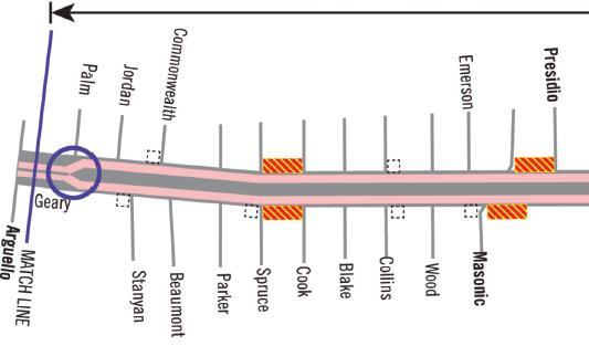
38 What we heard from area merchants: Major concern: elimination of all parking/loading spaces on block Land use needs between Spruce and Cook Delivery services Active driveways Medical offices Furniture, lumber and carpet stores Print-shops Maintain current stop locations and sizes
39 Options considered: Reduce size of bus bulbs Two-bus bulb acceptable, but still eliminates most spaces on block Change stop location Limited opportunities, would result in uneven spacing Change stop to local-only and keep existing bus zones Relatively low daily ridership: 1,600 vs. 4,500 average for Rapid stops No transfers to other Muni routes Saves travel time for through Rapid riders (11,000 daily) Preserves all parking/loading on block Outreach to USF students: no significant concerns
40 Recommendation Change stop to local-only and keep existing bus zones New traffic signal at Cook 41
41 Richmond Merchants Roundtable discussion of narratives Key issues raised: Adequacy of current bus performance Whether project benefits are overstated, impacts understated Maintaining boulevard character, including trees and landscaping Economic effects on businesses, especially during construction 42
42 Richmond Merchants Key issues raised (con t): Desire for No Build or phased implementation of elements other than bus-only lane Consider alternative designs in the Richmond: Side-running bus only lanes Peak hour bus-only lanes Bus lanes not painted red 43
43 Richmond Merchants Information presented on: Existing transit ridership and travel times Components of No Build and BRT alternatives Analysis methodology and projected future transit, traffic, and parking conditions Tree analysis and future boulevard design Economic effects of BRT Construction outreach and mitigation strategies 44
44 Richmond Merchants Construction Outreach and Mitigation Strategies Pre-Construction Survey Business and Community Advisory Committees Accessibility, Way-finding, and Advertisement Notification and Project Resources Business Technical Assistance and Support 45
45 Richmond Merchants Next Steps: Discussion process ongoing Working to provide additional information and address concerns in ways that meet purpose and need of the BRT project Commitment to ongoing communication with corridor merchants before and after project approvals 46
46 Geary Bus Rapid Transit Project Outreach Update SAN FRANCISCO COUNTY TRANSPORTATION AUTHORITY SAN FRANCISCO MUNICIPAL TRANSPORTATION AGENCY April 28, 2016
Geary Corridor Bus Rapid Transit
 Geary Corridor Bus Rapid Transit Near-term Improvements Update SAN FRANCISCO COUNTY TRANSPORTATION AUTHORITY SAN FRANCISCO MUNICIPAL TRANSPORTATION AGENCY Phasing Packages Phase 1 Near-term: Delivers project
Geary Bus Rapid Transit Project
 Geary Bus Rapid Transit Project Urban Forestry Council Planning and Funding Committee Meeting September 13, 2016 SAN FRANCISCO COUNTY TRANSPORTATION AUTHORITY SAN FRANCISCO MUNICIPAL TRANSPORTATON AGENCY
Geary Corridor Bus Rapid Transit SFMTA Citizens Advisory Committee
 Geary Corridor Bus Rapid Transit SFMTA Citizens Advisory Committee Project Update SAN FRANCISCO COUNTY TRANSPORTATION AUTHORITY SAN FRANCISCO MUNICIPAL TRANSPORTATION AGENCY August 6, 2015 Project Overview
Welcome! Thank you for joining us today for a Geary Rapid project open house. Geary Rapid Project. SFMTA.com/GearyRapid
 Welcome! Thank you for joining us today for a Geary Rapid project open house. Get the most out of this event: 1. Sign in and get your feedback sheet 2. Visit project information stations hosted by project
Geary Corridor Bus Rapid Transit: Staff-Recommended Alternative
 Geary Corridor Bus Rapid Transit: Staff-Recommended Alternative Urban Forestry Council January 24, 2014 SAN FRANCISCO COUNTY TRANSPORTATION AUTHORITY SAN FRANCISCO MUNICIPAL TRANSPORTATION AGENCY Today
Pedestrian and Bicycle Conditions
 Pedestrian and Bicycle Conditions Geary Citizens Advisory Committee May 8, 2014 SAN FRANCISCO COUNTY TRANSPORTATION AUTHORITY SAN FRANCISCO MUNICIPAL TRANSPORTATION AGENCY Topics Pedestrian Conditions
Public Comment Meeting Geary BRT Project Draft Environmental Impact Statement/Report
 Public Comment Meeting Geary BRT Project Draft Environmental Impact Statement/Report Open House and Opportunity to Provide Comments Public comments can be submitted to the court reporter stationed in the
Tonight is for you. Learn everything you can. Share all your ideas.
 Strathcona Neighbourhood Renewal Draft Concept Design Tonight is for you. Learn everything you can. Share all your ideas. What is Neighbourhood Renewal? Creating a design with you for your neighbourhood.
Better Market Street. Engineering, Maintenance & Safety Committee (EMSC) February 28, 2018
 February 28, 2018") Better Market Street Engineering, Maintenance & Safety Committee (EMSC) February 28, 2018 1 Market Street Market Street - San Francisco by rulenumberone2 2 Market Street is the... City s busiest pedestrian
Better Market Street Engineering, Maintenance & Safety Committee (EMSC) February 28, 2018 1 Market Street Market Street - San Francisco by rulenumberone2 2 Market Street is the... City s busiest pedestrian
Project Goal and Description. Why Broadway? Broadway SFMTA.COM/BROADWAY. The goal of the Broadway Safety Improvement
 PROJECT OVERVIEW Project Goal and Description The goal of the Broadway Safety Improvement d St Van Ness Ave Project is to improve safety and comfort for all who Franklin St Hyde St Octavia St Gough St
Lawrence Avenue Streetscape Concepts August 30, 2011
 Lawrence Avenue Streetscape Concepts August 30, 2011 Neighborhood Context Phase II: River to Western Ave. Phase I: Western Ave. to Clark St. Key Map Lawrence Ave. Existing Streetscape Conditions East of
SAN FRANCISCO MUNICIPAL TRANSPORTATION AGENCY
 THIS PRINT COVERS CALENDAR ITEM NO. : 10.2 DIVISION: Sustainable Streets BRIEF DESCRIPTION: SAN FRANCISCO MUNICIPAL TRANSPORTATION AGENCY Adopting Conceptual Proposal for Streetscape Improvements to Broadway,
Caltrans Sloat Boulevard Pedestrian Safety Project Response to Community Questions, Comments & Concerns
 Caltrans Sloat Boulevard Pedestrian Safety Project Response to Community Questions, Comments & Concerns Revised: May 10, 2016 The California Department of Transportation (Caltrans) is planning various
SAN FRANCISCO MUNICIPAL TRANSPORTATION AGENCY
 THIS PRINT COVERS CALENDAR ITEM NO.: 10.3 DIVISION: Sustainable Streets BRIEF DESCRIPTION: SAN FRANCISCO MUNICIPAL TRANSPORTATION AGENCY Approving various traffic and parking modifications on Bay Street
Vision Zero Priority Projects (March 2017)
") Key in 201 or of Key Potrero Ave., from Division to Cesar Chavez Begin Construction Spring 201 Winter 201 Achieved Safety measures include dedicated transit lane, sidewalk widening, buffers for existing
Key in 201 or of Key Potrero Ave., from Division to Cesar Chavez Begin Construction Spring 201 Winter 201 Achieved Safety measures include dedicated transit lane, sidewalk widening, buffers for existing
Van Ness Avenue Bus Rapid Transit (BRT) San Francisco Environment Commission Policy Committee
 San Francisco Environment Commission Policy Committee") Van Ness Avenue Bus Rapid Transit (BRT) San Francisco Environment Commission Policy Committee 04.30.12 Van Ness Avenue BRT Project Background Key north-south link in San Francisco s Rapid Transit network
Van Ness Avenue Bus Rapid Transit (BRT) San Francisco Environment Commission Policy Committee 04.30.12 Van Ness Avenue BRT Project Background Key north-south link in San Francisco s Rapid Transit network
MASONIC AVENUE STREET DESIGN STUDY Community Workshop 2. Masonic Ave Street Design Study Community Workshop 2 August 10, 2010
 Masonic Ave Street Design Study Community Workshop 2 August 10, 2010 Introduction MASONIC AVENUE STREET DESIGN STUDY Community Workshop 2 SF Municipal Transportation Agency Javad Mirabdal, Project Manager
Polk Streetscape Project
 What is this project? The Polk Streetscape Project is an effort to improve safety for everyone traveling on Polk Street between Union and McAllister streets. Also included in this project are paving, sewer
City of Sammamish. Welcome. Issaquah-Fall City Road Improvements Project Phase I Design: 242nd Avenue SE to Klahanie Drive SE
 Welcome Welcome to the third community meeting for the Issaquah-Fall City Road Improvements Project. AGENDA 6:00 p.m. Welcome and sign-in 6:10 p.m. Presentation 6:50 p.m. Open house Learn about the roadway
Data Analysis February to March Identified safety needs from reported collisions and existing travel patterns.
 Welcome! Thank you for participating in today s Valencia Bikeway Improvements workshop. Data Analysis February to March Identified safety needs from reported collisions and existing travel patterns. Initial
HARRISON STREET/OAKLAND AVENUE COMMUNITY TRANSPORTATION PLAN
 HARRISON STREET/OAKLAND AVENUE Community Workshop #4: Draft Plan Review December 3, 2009 D E S I G N, C O M M U N I T Y & E N V I R O N M E N T INTRODUCTIONS Key Project Staff: Alisa Shen, Project Manager,
Freeway ramp intersection study
 Freeway ramp intersection study Supporting Vision Zero: Zero traffic deaths in San Francisco by 2024 Study Goals: Primary Improve Safety Improve Accessibility Secondary Provide Efficient Circulation Accommodate
Protected Bike Lanes in San Francisco Mike Sallaberry SFMTA NACTO Workshop - Chicago IL
 Protected Bike Lanes in San Francisco Mike Sallaberry SFMTA 10 14 2011 NACTO Workshop - Chicago IL San Francisco 2 nd Highest Density in the U.S. 47 square miles Mild Climate Market Population ~810,000
Agenda. Overview PRINCE GEORGE S PLAZA METRO AREA PEDESTRIAN PLAN
 PRINCE GEORGE S PLAZA METRO AREA PEDESTRIAN PLAN May 28, 2008 Agenda Welcome and introductions Project overview and issue identification Planning context and strengths Design challenges and initial recommendations
Mission-Geneva Transportation Study Community Workshop 2 July 8, 2006
 Community Workshop 2 July 8, 2006 Small Group Workbook 1 Basic Improvements on Mission Street Streetscape. Pedestrian-scale lighting; landscaping; community art on utility boxes; more (possibly unique)
Outreach Approach RENEW SF served as the primary liaison with the North Beach community; the Chinatown. Executive Summary
 Executive Summary Executive Summary The Columbus Avenue Neighborhood Transportation Study s objective is to identify changes to transportation infrastructure and policies that could enhance the livability
REGIONAL BICYCLE AND PEDESTRIAN DESIGN GUIDELINES
 REGIONAL BICYCLE AND PEDESTRIAN DESIGN GUIDELINES November 16, 2011 Deb Humphreys North Central Texas Council of Governments Bicycle and Pedestrian Advisory Committee Snapshot of the Guide 1. Introduction
Dewey Area Traffic Calming Project
 SFMTA Municipal Transportation Agency Image: Crosswalk of California Street and Grant Avenue Dewey Area Traffic Calming Project 10 08 2013 SAN FRANCISCO, CALIFORNIA Tonight s Agenda Introductions Project
BETHEL ROAD AND SEDGWICK ROAD CORRIDOR STUDY
 DRAFT PLAN City Council Meeting August 14, 2017 STUDY AREA Sedgwick Corridor State Route 160, principal arterial with Class 3 access management designation, commuter and freight route, connection to SR
MASONIC AVENUE STREET DESIGN STUDY Community Workshop 3. Masonic Ave Street Design Study Community Workshop 3 September 30, 2010
 Masonic Ave Street Design Study Community Workshop 3 September 30, 2010 Introduction MASONIC AVENUE STREET DESIGN STUDY Community Workshop 3 SF Municipal Transportation Agency Javad Mirabdal, Project Manager
BD RESOLUTION NO RESOLUTION ADOPTING THE VISION ZERO RAMP INTERSECTION STUDY PHASE 1
 BD00 RESOLUTION NO. - RESOLUTION ADOPTING THE VISION ZERO RAMP INTERSECTION STUDY PHASE [NTIP PLANNING] FINAL REPORT WHEREAS, The Vision Zero Ramp Intersection Study Phase was recommended by Commissioner
Mission Bay Loop (MBL) Public Meeting
 Public Meeting") Mission Bay Loop (MBL) Public Meeting La Scuola Internazionale di San Francisco, November 18, 2014 Frequently Asked Questions 1. When would construction have to start before the SFMTA loses TIGER funds?
Mission Bay Loop (MBL) Public Meeting La Scuola Internazionale di San Francisco, November 18, 2014 Frequently Asked Questions 1. When would construction have to start before the SFMTA loses TIGER funds?
California Department of Transportation, District 4. Sloat Boulevard Project Skyline Blvd. to 19 th Ave. Community Update January 13, 2016
 California Department of Transportation, District 4 Sloat Boulevard Project Skyline Blvd. to 19 th Ave. Community Update January 13, 2016 Agenda Welcome and introductions Project overview, history and
Omaha s Complete Streets Policy
 Omaha s Complete Streets Policy (Adopted August 2015) VISION To create great places and enhance our quality of life, the City of Omaha will provide safe, accessible streets for all users. Complete Streets
ALTERNATIVES SCREENING REPORT
 VAN NESS AVENUE BUS RAPID TRANSIT (BRT) ALTERNATIVES SCREENING REPORT Revised Draft, 3/28/08 San Francisco County Transportation Authority 1 Introduction The San Francisco County Transportation Authority
Memo. Ocean Avenue Corridor Design Project Public Workshop #2 Summary
 Ocean Avenue Corridor Design Project Public Workshop #2 Summary The second public workshop for the Ocean Avenue Corridor Design Project was held on Wednesday, May 14, 2014 from, 6 to 8 pm at Lick Wilmerding
FOLSOM-HOWARD STREETSCAPE OVERVIEW
 FOLSOM-HOWARD STREETSCAPE OVERVIEW SoMa residents should have the same kinds of amenities that other neighborhoods have. The Folsom- Howard Streetscape Project will make SoMa more livable by making it
SAN FRANCISCO MUNICIPAL TRANSPORTATION AGENCY
 THIS PRINT COVERS CALENDAR ITEM NO. : 8 DIVISION: Sustainable Streets BRIEF DESCRIPTION: SAN FRANCISCO MUNICIPAL TRANSPORTATION AGENCY Approving traffic and parking modifications to implement seven projects
SFMTA SAN FRANCISCO MUNICIPAL TRANSPORTATION AGENCY
 SFMTA SAN FRANCISCO MUNICIPAL TRANSPORTATION AGENCY VAN NESS BUS RAPID TRANSIT PROJECT UPDATE PRESENTATION TO SFMTA BOARD OF DIRECTORS RELEASE OF DRAFT ENVIRONMENTAL IMPACT STATEMENT / REPORT 10 18 2011
US 278 Corridor Concept Presentation. Avondale Estates Intersection Improvement/Roundabout and Road Diet Feasibility Study March 19, 2015
 US 278 Corridor Concept Presentation Avondale Estates Intersection Improvement/Roundabout and Road Diet Feasibility Study March 19, 2015 Thanks to our Partners Atlanta Regional Commission Georgia Department
THE ALAMEDA CONCEPT DESIGN COMMUNITY MEETING 3. A Plan for The Beautiful Way JANUARY 28, 2010
 CONCEPT DESIGN COMMUNITY MEETING 3 JANUARY 28, 2010 AGENDA INTRODUCTION COMMUNITY INPUT ROADWAY STUDIES STREETSCAPE DESIGN STATIONS DISCUSSION SUMMARY AND DISCUSSION NEXT STEPS CLOSE INTRODUCTION SCHEDULE
3.5 Pedestrian and Bicycle Transportation
 3.5 Pedestrian and Bicycle Transportation 3.5.1 Regulatory Setting Several policies and plans guide the development of non-motorized transportation environments on and around the Geary corridor. 3.5.1.1
September 20, 2016 L Taraval Rapid Project SFMTA Board of Directors Meeting
 September 20, 2016 L Taraval Rapid Project SFMTA Board of Directors Meeting WHY TARAVAL STREET L TARAVAL PROJECT GOALS 1. Improve state of good repair of our transit system Track and overhead replacement
Data Analysis February to March Identified safety needs from reported collisions and existing travel patterns.
 Welcome! Thank you for participating in today s Valencia Bikeway Improvements workshop. Data Analysis February to March Identified safety needs from reported collisions and existing travel patterns. Initial
Technical Working Group November 15, 2017
 Technical Working Group November 15, 2017 Welcome and Introductions Project Partners Regional Transportation District (RTD) Colorado Department of Transportation (CDOT) Denver Regional Council of Governments
VISION ZERO SF: ELIMINATING TRAFFIC DEATHS BY 2024 JANUARY 5, 2017
 Through Vision Zero SF we commit to working together to prioritize street safety and eliminate traffic deaths in San Francisco by 2024 VISION ZERO SF: ELIMINATING TRAFFIC DEATHS BY 2024 JANUARY 5, 2017
HIGHBURY AVENUE/HAMILTON ROAD INTERSECTION IMPROVEMENTS PUBLIC INFORMATION CENTRE 1 MAY 14, 2015
 HIGHBURY AVENUE/HAMILTON ROAD INTERSECTION IMPROVEMENTS Municipal Class Environmental Assessment PUBLIC INFORMATION CENTRE 1 MAY 14, 2015 ACCESSIBILITY Under the Accessibility Standards 2015 for Customer
WELCOME Mission-Geneva Transportation Study
 WELCOME Mission-Geneva Transportation Study Study Process and Schedule 2005 2006 Oct Nov Dec Jan Feb Mar Apr May Jun Jul Aug Sept Oct Task 2 Develop Outreach Plan Task 3 Document Existing Conditions/ Prioritize
TRAFFIC ACTION PLAN. Laurie Meadows Neighborhood CITY OF SAN MATEO
 TRAFFIC ACTION PLAN Laurie Meadows Neighborhood CITY OF SAN MATEO Draft January 2017 Table of Contents Introduction... 2 The Traffic Forum Process... 5 Neighborhood Traffic Issues... 7 Neighborhood Recommendations
Community Task Force November 15, 2017
 Community Task Force November 15, 2017 Welcome and Introductions Project Partners Regional Transportation District (RTD) Colorado Department of Transportation (CDOT) Denver Regional Council of Governments
Replace century-old sewer & water pipes Pedestrian-scale sidewalk lighting
 PROJECT OVERVIEW The Masonic Avenue Streetscape Project is an effort to improve safety for everyone travelling on Masonic Avenue between Geary Boulevard and Fell Street. This project will bring a variety
Long Island Rail Road Expansion Project Floral Park to Hicksville
 Long Island Rail Road Expansion Project Floral Park to Hicksville Final Environmental Impact Statement Appendix 1-D Complete Streets Policy Checklist April 2017 0902ML PIN: Project Location: 18A-4 Floral
Closing Plenary Session
 TRAFFIC SAFETY CONFERENCE Closing Plenary Session June 9, 2017 Las Colinas, TX Order of Report Out June 9, 2017 Las Colinas, TX Distracted Driving Prioritized Countermeasures Countermeasure 4a Systemically
to the Public Information Centre for the Downtown Traffic Study
 to the Public Information Centre for the Downtown Traffic Study City of Sault Ste. Marie July 25, 2018 Purpose of Study Determine if changes to one-way corridors can enhance downtown s character and spaces
Complete Streets Policy DAVID CRONIN, P.E., CITY ENGINEER
 Complete Streets Policy DAVID CRONIN, P.E., CITY ENGINEER Complete Streets City Commission adopted a Complete Streets policy in 2012 Complete Streets are road networks that are designed for all users:
Pedestrian and Bicycle Improvements in Balboa Park Station Area
 Pedestrian and Bicycle Improvements in Balboa Park Station Area Jamie Parks & Jen Wong, SFMTA, Livable Streets December 15, 2015 Balboa Park Station CAC Monthly Meeting Vision Zero SF Zero traffic deaths
BALBOA AREA: TRANSPORTATION PROJECTS & PLANNING
 BALBOA AREA: TRANSPORTATION PROJECTS & PLANNING TRANSPORTATION FOR ALL AGES, ABILITIES & MEANS CHANGING PATTERNS: TRENDING TO WALKING, BIKING, TRANSIT San Francisco s Change in Number of Commuters by Mode
M14A/D Select Bus Service
 M14A/D Select Bus Service Manhattan Community Board 6: April 1, 2019 New York City Transit 2 Background M14 Select Bus Service M14 was identified as a critical future SBS corridor in past BRT studies as
North Shore Transportation Improvement Strategy
 North Shore Transportation Improvement Strategy Preliminary, Near-term Recommendation 2016 April Transportation Improvement Strategy (TIS) Comprehensive and Analytical A multi-modal transportation strategy
Memorandum. M:\Board\Board Meetings\2015\Memos\09 Sep\BRT Reports\Geary Report\Geary BRT Sep2015 Board Update
 Memorandum September 22, 2015 Transportation Authority Board: Commissioners Weiner (Chair), Cohen (Vice Chair), Avalos, Breed, Campos, Christensen, Cohen, Farrell, Kim, Mar, Tang and Yee Eric Cordoba Deputy
Geary Community Advisory Committee Tuesday, March 20, :00 pm One South Van Ness, 7 th floor, Union Square Conference Room
 Geary Community Advisory Committee Tuesday, March 20, 2018 6:00 pm One South Van Ness, 7 th floor, Union Square Conference Room Geary CAC Member Attendees Sana Ahmed Daniel Calamuci Claude Imbault Annie
Transportation Planning Division
 Transportation Planning Division Presentation Outline Study Tasks Recap of Previous Meeting Stakeholder Interviews Data Collection Design Principles Tool Box Recommendations Schedule Moving Forward North
SAN FRANCISCO MUNICIPAL TRANSPORTATION AGENCY
 THIS PRINT COVERS CALENDAR ITEM NO. : 11 DIVISION: Transit BRIEF DESCRIPTION: SAN FRANCISCO MUNICIPAL TRANSPORTATION AGENCY Approving parking and traffic modifications on San Bruno Avenue included in the
95 th Street Corridor Transportation Plan. Steering Committee Meeting #2
 95 th Street Corridor Transportation Plan Steering Committee Meeting #2 February 18, 2015 PURPOSE OF THE MEETING Update Steering Committee Present Community/Stakeholder Survey Results Present Transportation
NORTH TURNAROUND. Recommended Design: Expand the existing transit terminal
 NORTH TURNAROUND Recommended Design: Expand the existing transit terminal Feedback from stakeholders and the public: Make it easy to transfer between local and Rapid Transit service Why is this design
CLOSED. The draft concept design has been broken down into 5 categories for the purpose of this survey:
 Old Strathcona s neighbourhood renewal process is now at the draft concept design phase. Over the last several months, the city has been gathering local knowledge and resident input that has been used
Columbia Pike Implementation Team (CPIT) Meeting
 Meeting") Columbia Pike Implementation Team (CPIT) Meeting November 30, 2010 Agenda Introductions / Purpose of Meeting Review of project goals Multimodal project: 10% street design between the curbs Discussion Multimodal
Columbia Pike Implementation Team (CPIT) Meeting November 30, 2010 Agenda Introductions / Purpose of Meeting Review of project goals Multimodal project: 10% street design between the curbs Discussion Multimodal
MOBILITY WORKSHOP. Joint City Council and Transportation Commission May 5, 2014
 MOBILITY WORKSHOP Joint City Council and Transportation Commission May 5, 2014 Review of General Plan M-1 Develop world-class transit system M-3 Maintain/enhance pedestrian-oriented City M-4 Create comprehensive
AGENDA REPORT. Issue: Discussion of potential improvements on Barnwell Road at Niblick Drive
 AGENDA REPORT To: From: By: Honorable Mayor and City Council Members Warren Hutmacher, City Manager Tom Black, Public Works Director Date: March 23, 2016 Agenda: March 28, 2016 WORK SESSION AGENDA: Barnwell
10.0 CURB EXTENSIONS GUIDELINE
 10.0 CURB EXTENSIONS GUIDELINE Road Engineering Design Guidelines Version 1.0 March 2017 City of Toronto, Transportation Services City of Toronto Page 0 Background In early 2014, Transportation Services
Retrofitting Urban Arterials into Complete Streets
 Retrofitting Urban Arterials into Complete Streets John N. LaPlante, P.E., P.T.O.E., T.Y. Lin International Prepared for: Illinois Traffic Engineering & Safety Conference Urbana, Illinois October 18, 2007
Upper Market Street Bike Lane Project
 Upper Market Street Bike Lane Project 17th Street to Octavia Boulevard 6 30 2010 SAN FRANCISCO, CALIFORNIA Agenda San Francisco & Sustainable Transportation Project Goals Outreach & Coordination Project
Ann Arbor Downtown Street Plan
 1 Ann Arbor Downtown Street Plan Public Workshop #1 We know that. 2 Public right-of-way (streets, sidewalks, and alleys) make up 30% of the total District area of downtown. Streets need to provide mobility
Downtown Naples Mobility and Connectivity Study. Naples City Council Presentation January 2017
 Downtown Naples Mobility and Connectivity Study Naples City Council Presentation January 2017 Agenda 1. Introduction 2. Scope Review 3. Project Schedule 4. Existing Conditions 5. Public Charrette 6. Mobility
SAN FRANCISCO MUNICIPAL TRANSPORTATION AGENCY
 THIS PRINT COVERS CALENDAR ITEM NO.: 13 DIVISION: Sustainable Streets BRIEF DESCRIPTION: SAN FRANCISCO MUNICIPAL TRANSPORTATION AGENCY Endorsing the Planning Department s 2014 Update to the conceptual
Chapter 3 BUS IMPROVEMENT CONCEPTS
 Chapter 3 BUS IMPROVEMENT CONCEPTS The purpose of this chapter is to describe potential bus improvement strategies and potential impacts or implications associated with BRT implementation within the existing
Citizen Advisory Group Meeting #8 May 5, Welcome. Today s meeting will focus on: Land Use & Transportation CHARLOTTEPLANNING.
 Citizen Advisory Group Meeting #8 May 5, 2010 Welcome. Today s meeting will focus on: Land Use & Transportation CHARLOTTEPLANNING.ORG Meeting Agenda Handouts: o Meeting Agenda o Summary of East Seventh
Station 1: Street & Sidewalk Upgrades
 Station 1: Street & Sidewalk Upgrades Existing no left turn; Potential left turn arrow, see Circulation Study boards for more information Thru-lane guidance Improved lead-in green bike lane 17TH ST CASTRO
WELCOME WIGGLE NEIGHBORHOOD GREEN CORRIDOR COMMUNITY OPEN HOUSE
 WELCOME WIGGLE NEIGHBORHOOD GREEN CORRIDOR COMMUNITY OPEN HOUSE Meeting Objectives: Provide results of feedback submitted during the June 11, 2013 Open House Display preliminary locations and features
Oakland Pedestrian Master Plan Oakland Pedestrian Plan Draft Recommendations Chapter Outline
 EISEN LETUNIC T R A N S P O R T A T I O N, ENVIRO N M E N TA L A N D URBAN PLANNIN G MEMORANDUM To Oakland Pedestrian Plan Technical Advisory Committee & Pedestrian Advisory Group From Victoria Eisen Date
APPENDIX A: Complete Streets Checklist DRAFT NOVEMBER 2016
 APPENDIX A: Complete Streets Checklist DRAFT NOVEMBER 2016 Complete Streets Checklist MetroPlan Orlando s Complete Streets Checklist is an internal planning tool for staff to further implementation of
Road Diets FDOT Process
 Florida Department of TRANSPORTATION Road Diets FDOT Process Humberto Castillero, PE, PTOE Roadway Design Office Purpose of Guide Develop a statewide lane elimination review process Balance state & local
CURBSIDE ACTIVITY DESIGN
 5 CURBSIDE ACTIVITY DESIGN This chapter provides design guidance for separated bike lanes adjacent to curbside activities including parking, loading and bus stops. Typical configurations are presented
Transit Planning at 3 Scales: the Network, Corridor, and Station Levels
 Transit Planning at 3 Scales: the Network, Corridor, and Station Levels Case studies of challenges, solutions and lessons learned Elizabeth Mros-O Hara, John Katz, Charles Carlson, Alicia McIntire, and
Designing Complete Streets: What you need to know
 Designing Complete Streets: What you need to know Getting from this to this. Continuous sidewalk Buffer w/trees Bicycle lane Raised median Buildings close to the street Flexibility in design Design and
SFMTA s Services for Seniors and People with Disabilities. San Francisco Municipal Transportation Board July 17, 2018
 SFMTA s Services for Seniors and People with Disabilities San Francisco Municipal Transportation Board July 17, 2018 SFMTA s Commitment to Access Address issues of accessibility across all transportation
Lincoln Neighborhood Corridor Plan The LiNC
 CITY OF SANTA MONICA Lincoln Neighborhood Corridor Plan The LiNC PLANNING COMMISSION September 2, 2015 COMMUNITY DESIGN + ARCHITECTURE TEAM: Community Design + Architecture Iteris Studio 111 Urban Place
NEWMARKET UPHAM S CORNER
 SOUTH STATION Planning Initiative NEWMARKET UPHAM S CORNER COLUMBIA ROAD (P) FOUR CORNERS/GENEVA Working Advisory Group (WAG) Meeting #5 TALBOT AVENUE MORTON STREET BLUE HILL AVE/CUMMINS HWY (P) RIVER
Public Works Committee Meeting Richard E. Mastrangelo Council Chamber November 20, 2017
 Public Works Committee Meeting Richard E. Mastrangelo Council Chamber November 20, 2017 Purpose of Meeting Why are we here? Project Recap/Updates Project Limits/Segments Road Diet Concept Lessons Learned
MARTIN LUTHER KING JR. WAY
 OCTOBER 2011 40 Vision and Goals The Martin Luther King, Jr. Way Illustrative Master Plan that follows has been developed through a process of community involvement. It expresses a long term vision for
Community Meeting February 27, 2007 Dorchester Avenue Transportation & Streetscape Improvements Action Plan February 27, 2007
 Community Meeting Tonight s Agenda 6:00 Introductions South Boston/Dot Ave Improvement Study Background 6:15 Consultant Introductions Review of Scope and Schedule Review of Proposed Corridor Wide Guidelines
TRANSPORTATION IMPROVEMENT STRATEGY
 TRANSPORTATION IMPROVEMENT STRATEGY A Vision for Staten Island North Shore November 2016 1 EXISTING CONDITIONS Transit Conditions MTA Bus Staten Island Railroad Peak Directional Traffic Volume (per hour)**:
Derby Street. Project Updates. Salem, Massachusetts
 Derby Street Project Updates Salem, Massachusetts September 13, 2017 Project Limits Derby Street Project Objectives 1. Improve complete streets elements on Derby Street 2. Improve sidewalks on finger streets
PRINCE GEORGE S PLAZA METRO AREA PEDESTRIAN PLAN
 PRINCE GEORGE S PLAZA METRO AREA PEDESTRIAN PLAN May 28, 2008 Agenda Welcome and introductions Project overview and issue identification Planning context and strengths Design challenges and initial recommendations
5. RUNNINGWAY GUIDELINES
 5. RUNNINGWAY GUIDELINES These guidelines should be considered collectively when making runningway decisions. A runningway is the linear component of the transit system that forms the right-of-way reserved
PROJECT OVERVIEW. 20th Avenue Project Limits (Lincoln Way to Wawona St)
") PROJECT OVERVIEW In 2014, San Francisco adopted Vision Zero as City policy, with a commitment to eliminate all traffic deaths in the City by 2024. nue Project Limits (Lincoln Way to St) Collision data
PROJECT OVERVIEW In 2014, San Francisco adopted Vision Zero as City policy, with a commitment to eliminate all traffic deaths in the City by 2024. nue Project Limits (Lincoln Way to St) Collision data
From Disarray to Complete Street:
 From Disarray to Complete Street: Utilizing BRT to improve bus service, pedestrian safety, and traffic organization in the South Bronx BRT, TOD and Complete Streets TRB BRT Conference June 19, 2018 We
C C C
 C-012-001 Thank you for your support for the creation of new public space and nonmotorized access between downtown and the waterfront through the Overlook Walk, the East-West Connections, and the Promenade.
4 DISRUPTION MANAGEMENT PLAN HIGHWAY 7 RAPIDWAY CONSTRUCTION BETWEEN BAYVIEW AVENUE AND WARDEN AVENUE TOWNS OF MARKHAM AND RICHMOND HILL
 4 DISRUPTION MANAGEMENT PLAN HIGHWAY 7 RAPIDWAY CONSTRUCTION BETWEEN BAYVIEW AVENUE AND WARDEN AVENUE TOWNS OF MARKHAM AND RICHMOND HILL The Transportation Services Committee recommends the adoption of
Public Involvement Meeting Tuesday, June 13, Albany Shaker Road Corridor Study
 Public Involvement Meeting Tuesday, June 13, 2017 Albany Shaker Road Corridor Study Agenda / Meeting Outline 1. Introduce the project 2. Complete Streets 3. Share/confirm our findings 4. Your Opinion 5.