TRANSPORTATION IMPROVEMENT STRATEGY
|
|
|
- Lucas Bishop
- 5 years ago
- Views:
Transcription


1 TRANSPORTATION IMPROVEMENT STRATEGY A Vision for Staten Island North Shore November

2 EXISTING CONDITIONS Transit Conditions MTA Bus Staten Island Railroad Peak Directional Traffic Volume (per hour)**: Bay Street Richmond Terrace Victory Boulevard Castleton Ave Front Street Van Duzer/St. Pauls Tompkins Ave 22 bus routes originate at the St. George Ferry Terminal More than 11,500 bus riders board these routes at the Ferry Terminal on an average weekday 7,343 average weekday trips at St. George and Tompkinsville SIR Stations (2015) Staten Island Ferry 70,000 Daily Passengers (2016) 13,598 Manhattan-bound commuters daily between 7am-10am* 1000 vph vph vph 800 vph 600 vph (two-way volumes) vph vph * NYMTC Hub Bound Travel 2014 ** NYC EDC


3 CURRENT PEAK VOLUME & SPEED Congested intersections throughout study area Consistent volumes to/from the ferry during commuting peak periods Traffic Volume at Ferry Terminal Traffic Volume at Ferry Terminal Towards Terminal Richmond Terrace 553 Towards Terminal Richmond Terrace 490 Away from Terminal Bay Street 711 Richmond Terrace Existing AM Peak Volumes & Speeds towards Ferry 510 Bay Street 676 Away from Terminal Bay Street 651 Richmond Terrace Existing PM Peak Volumes & Speeds from Ferry 538 Bay Street 575 Note: Volumes based on 2016 data (Source: EDC) 3
 45K sf. retail, 950 apartments, 743 parking spaces Lighthouse Point (2019) 74K sf.")
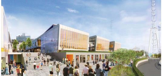
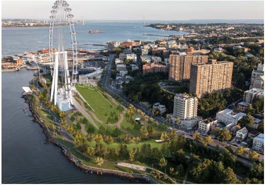
4 HERE S WHAT S COMING St George Waterfront Redevelopment Outlet Mall (2017) 1.06M sf. mixed-use, 1,250-space garage NY Wheel (2018) 420K sf. mixed-use, 950-space garage New Stapleton Waterfront Development Plan (2017) 45K sf. retail, 950 apartments, 743 parking spaces Lighthouse Point (2019) 74K sf. mixed-use, 109 apartments, 800-seat cinema, 164 hotel rooms, 345 parking spaces Proposed Bay Street Corridor Rezoning ( ) Potential 353K sf. mixed-use, 2,556 apartments, 1,295 parking spaces 4
5 FERRIES WILL CARRY MOST OF THE NEW TRAVELERS Ferry carries the largest mode share of new trips to major attractions Vehicle trips include auto, taxi, truck, and tour bus Daily Weekday Trips Walk, 146 (0.3%) Vehicles Trips, (23.2%) Train Trips, 695 (1.4%) Ferry, (72.4%) City Bus, 1344 (2.7%) Total Trips: 48,951(similar mode share trends on weekends with projected 58,916 trips) Source: St George Waterfront Redevelopment EIS
6 AS PART OF THE 2013 EIS, THE CITY HAS ALREADY COMMITTED TO: Staffing NYPD Traffic Enforcement Agents to manage mall opening & SI Yankee Games Roadway & Traffic Improvements Increased capacity of Wall St Ramp Signal timing changes & marking improvements at key intersections Wall & Schuyler Street Reversals Traffic signal at Richmond Terrace/Schuyler Street Northbound Left- and U-turn restrictions at Richmond Terrace at Wall Street Semi-trucks delivery restrictions to off-peak hours where appropriate Ongoing monitoring and adjustments as needed 6

7 THE CITY HAS ALREADY COMMITTED TO: SI Ferry Study the possibility of providing ferry service from Staten Island to midtown Manhattan (Winter 2017) Study improving passenger throughput at St. George & Whitehall Ferry Terminals Construction of three new passenger capacity ferries ( ) 7
 Front Street and Connector Street Reconstruction (EDC, completed) 2015 Richmond Terrace, South Avenue to Port Richmond Avenue Clove Road, Richmond Terrace to Forest")
8 RECENT KEY DOT AND EDC PROJECTS 2016 Bay Street and Victory Boulevard (completed) Forest Avenue, South Avenue to Willowbrook Road (implementation underway) Richmond Terrace and Port Richmond Avenue (implementation to start in Nov) Front Street and Connector Street Reconstruction (EDC, completed) 2015 Richmond Terrace, South Avenue to Port Richmond Avenue Clove Road, Richmond Terrace to Forest Avenue 2014 Richmond Terrace, Western Avenue to Morningstar Road 2013 Hyatt Street, St. Mark s Place to Stuyvesant Place Bay St & Victory Blvd 2016 SIP 8

9 ADDITIONAL STEPS THE CITY IS TAKING The City identified key projects to reduce congestion and improve mobility and safety through: Traffic Enforcement and Roadway Changes Travel Demand Management Freight Management Pedestrian/Bicycle Safety Enhancements All of this will be coordinated by a new DOT North Shore Planner 9
10 POTENTIAL TRAFFIC ENFORCEMENT AND ROADWAY CHANGE RECOMMENDATIONS Project Enforce Placard Rules & Removal of Illegally Parked Vehicles North Shore TEA Deployment Strategy Richmond Terrace Capacity Enhancement Circulation & Access Improvement: Street Dir. Install 3 Traffic Signals, if warranted Signal Timing Optimization & Progression Responsible Agency Timing* Relative Impact Implementation Difficulty NYPD TBD High High NYPD TBD High High Cost Estimate Agency Resources $300K Areawide Funding Identified if feasible N Partial DOT, NYPD TBD High Low $2.5K/int. Partial DOT 2017 High Low $50K Y DOT TBD High Low $600K Y DOT 2017 Medium Low $25K Y Turn Restrictions DOT Medium Medium $7.5K Y *All TBD pending community input and further analysis 10

11 TRAFFIC ENFORCEMENT & ROADWAY CHANGES Installation and enforcement of rush hour regulations will improve traffic flow on Richmond Terrace between St. Peter s Place and the ferry terminal Example: Richmond Terrace capacity enhancements at Stuyvesant Place 11

12 TRAFFIC ENFORCEMENT & ROADWAY CHANGES TEAs Deployment Strategy 3 committed at peak traffic times in the St. George Waterfront Redevelopment EIS to organize traffic flow In addition, potential for the 120th Precinct and SI Borough Command to deploy additional agents 12
")
13 TRAFFIC ENFORCEMENT & ROADWAY CHANGES Circulation and Access Extend one-way reversal on Wall Street Eliminating head-on geometry at Wall Street/Stuyvesant Place will improve safety, reduce congestion, and help circulation (EIS mitigation) 13
14 POTENTIAL TRAVEL DEMAND MANAGEMENT RECOMMENDATIONS Project Increase bus service during peak hours: S46/S94) Responsible Agency Timing* Relative Impact Implementation Difficulty Cost Estimate Funding Identified if feasible MTA, DOT TBD High High $300K-$500K N Transit Signal Priority DOT, MTA TBD High Medium $17K/int. Y Variable Priced Parking outside development DOT, EDC, Business TBD Medium High Agency Resources Y Activate Bi-Direction Victory Blvd Bus Lanes during Peak Periods Go Smart- North Shore Implementation Install real time information signs at bus stops DOT, MTA TBD Medium Medium $2M N DOT 2017 Medium Low $350K-$500K Y DOT, MTA TBD Medium Low $25K/location Partial North Shore BRT (Study) MTA Medium Low $5M Y *All TBD pending community input and further analysis 14


15 TRAVEL DEMAND MANAGEMENT Education and Outreach: Go Smart NYC PROJECT FUNDING: Federal Grant PROJECT BACKGROUND/SCOPE: Based on 10+ Years of national and international best practices in Personalized Travel Choice programming. NYC s first Go Smart program was launched in Queens CB5 in PROJECT STRUCTURE: Opt-in Education and Encouragement program that targets neighborhoods, employers, and institutions to improve travel outcomes for drivers, cyclists, transit users, and pedestrians. 15
16 POTENTIAL FREIGHT MANAGEMENT RECOMMENDATIONS Project Evaluate Commercial Loading/Unloading areas along major corridors Responsible Agency Timing* Relative Impact Implementation Difficulty Cost Estimate Funding Identified if feasible DOT 2017 Medium Low DOT Resources Y Compliance monitoring of truck routes DOT, NYPD 2017 Medium Low DOT Resources Y Business Engagement for Consolidated Management of Goods & Waste Encourage off-hour deliveries to minimize deliveries during peak periods *All TBD pending community input and further analysis DOT 2017 Low Medium DOT Resources Y DOT, Businesses N/A Low Medium DOT Resources Y 16
17 POTENTIAL PEDESTRIAN/BIKE SAFETY RECOMMENDATIONS Project Upgrade all Ped Ramps (ADA Compliant) Responsible Agency Timing* Relative Impact Implementation Difficulty Cost Estimate Funding Identified if feasible DOT TBD High Medium $6K/ramp Y Install High-Visibility Crosswalks DOT 2017-Beyond High Low $2.5K/intersection Y Install pedestrian countdown timers where feasible DOT TBD High Low $2K/timer Y SIR Station Enhancements EDC/MTA/DOT TBD Medium Medium $2.5M N Improve Bicycle Facilities DOT TBD Medium Medium $2.5K/rack + $800K/10 miles of paint Y Wayfinding Signage DOT/EDC TBD Low Low $1.05M Y *All TBD pending community input and further analysis 17
18 POTENTIAL PEDESTRIAN/BIKE SAFETY RECOMMENDATIONS Project Responsible Agency Timing* Relative Impact Implementation Difficulty Cost Estimate Funding Identified if feasible Hannah St Bridge Bicycle Improvements DOT TBD High High $10-20M N Tompkinsville Esplanade EDC TBD High High $68M N Richmond Terrace near St. George Terminal DOT TBD High Medium $11.3M N Bay Street and Victory Boulevard DOT TBD High Medium $7.3M N Saint Paul s Avenue and Van Duzer Street DOT TBD High Medium $2.9M N *All TBD pending community input and further analysis 18

19 PEDESTRIAN/BICYCLE SAFETY ENHANCEMENTS Improve wayfinding signage at St. George Terminal and through study area Install high visibility crosswalks & pedestrian signals to increase pedestrian safety Bay Street at St. Julian Place 19

20 PEDESTRIAN/BICYCLE SAFETY ENHANCEMENTS Safe Routes to Transit Complete SIR Station area improvements at Tompkinsville & Stapleton Stations Increase number of bus shelters where feasible to enhance pedestrian and transit environment Potential Stapleton SIR Station entrance improvements (Source: EDC) 20

21 MOVING FORWARD The City plans to: Advance conversations with MTA leadership & key stakeholders Present recommendations to the community in order to determine priorities and assess potential trade-offs Implement select projects in anticipation of mall opening Finalize & secure funding for longer-term projects Continue to monitor and evaluate projects 21

22 THANK YOU! Questions? NYC DOT NYC DOT nyc_dot NYC DOT 22
North Shore Transportation Improvement Strategy
 North Shore Transportation Improvement Strategy Preliminary, Near-term Recommendation 2016 April Transportation Improvement Strategy (TIS) Comprehensive and Analytical A multi-modal transportation strategy
Tunnel Reconstruction South 5 th Street Association October 16, 2018
 Tunnel Reconstruction South 5 th Street Association October 16, 2018 Reconstructing the Tunnel 2 Service During Tunnel Reconstruction April 2019 through July 2020 3 Projected Cross River Travel Paths of
Tunnel Reconstruction Brooklyn CB 1 August 14, 2018
 Tunnel Reconstruction Brooklyn CB 1 August 14, 2018 Reconstructing the Tunnel 2 Service During Tunnel Reconstruction April 2019 through July 2020 3 Projected Cross River Travel Paths of Customers The Service
M14A/D Select Bus Service
 M14A/D Select Bus Service Manhattan Community Board 6: April 1, 2019 New York City Transit 2 Background M14 Select Bus Service M14 was identified as a critical future SBS corridor in past BRT studies as
43 rd Avenue, Skillman Avenue Protected Bike Lanes
 43 rd Avenue, Skillman Avenue Protected Bike Lanes Presented to Queens Community Board 2 Transportation Committee - November 6, 2017 43 rd Avenue, Skillman Avenue: Presentation Overview Background Project
Proposed. City of Grand Junction Complete Streets Policy. Exhibit 10
 Proposed City of Grand Junction Complete Streets Policy Exhibit 10 1 City of Grand Junction Complete Streets Policy Vision: The Complete Streets Vision is to develop a safe, efficient, and reliable travel
5. RUNNINGWAY GUIDELINES
 5. RUNNINGWAY GUIDELINES These guidelines should be considered collectively when making runningway decisions. A runningway is the linear component of the transit system that forms the right-of-way reserved
ITS-NY ANNUAL MEETING Bus Rapid Transit in New York City: Bus Lane Operations on One-Way Arterial Streets
 ITS-NY ANNUAL MEETING Bus Rapid Transit in New York City: Bus Lane Operations on One-Way Arterial Streets June 9, 2011 Ted Orosz AICP, Director Long Range Bus Planning MTA New York City Transit 1 Overview
Queensboro Bridge Bus Priority Study: Summary of Recommendations. Presentation to Manhattan Community Board 8 May 4, 2011
 : Summary of Recommendations Presentation to Manhattan Community Board 8 May 4, 2011 1 Overview Study Goal: Identify cost-effective ways to improve bus speed and reliability for local and express buses
Better Market Street Project Update. Urban Forestry Council September 17, 2014
 Better Market Street Project Update Urban Forestry Council September 17, 2014 Project Area Limits Better Market Street Schedule Market Street City s busiest transit corridor Over 85 buses per hour 14 surface
Presentation to Media. February 27, 2008
 Anacostia Waterfront Nationals Ballpark Transportation Management Plan Presentation to Media February 27, 2008 Overarching Goals of DDOT s Ballpark TMP Organize and manage traffic to ensure pedestrian
Outreach Approach RENEW SF served as the primary liaison with the North Beach community; the Chinatown. Executive Summary
 Executive Summary Executive Summary The Columbus Avenue Neighborhood Transportation Study s objective is to identify changes to transportation infrastructure and policies that could enhance the livability
C C C
 C-012-001 Thank you for your support for the creation of new public space and nonmotorized access between downtown and the waterfront through the Overlook Walk, the East-West Connections, and the Promenade.
Short-Term Enhancements Improvements to keep Austin moving. MetroRapid
 Short-Term Enhancements Improvements to keep Austin moving Long-Term Investments Projects to support our future Mobility Hubs MetroRapid MetroRail MetroExpress Commuters Connectors Circulators Project
Bus Rapid Transit Plans
 Twin Cities Region Bus Rapid Transit Plans ULI Minnesota Workshop Connecting Bus Rapid Transit to the Community December 15, 2009 John Levin Director of Service Development Metro Transit Metropolitan Area
Solana Beach Comprehensive Active Transportation Strategy (CATS)
") Solana Beach Comprehensive Active Transportation Strategy (CATS) 3.0 Goals & Policies The Solana Beach CATS goals and objectives outlined below were largely drawn from the Solana Beach Circulation Element
Solana Beach Comprehensive Active Transportation Strategy (CATS) 3.0 Goals & Policies The Solana Beach CATS goals and objectives outlined below were largely drawn from the Solana Beach Circulation Element
Welcome and Introductions Overview of the Study to Date Community Involvement Intersection Improvement Concepts Bike-Ped Recommendations ITS
 Welcome and Introductions Overview of the Study to Date Community Involvement Intersection Improvement Concepts Bike-Ped Recommendations ITS Recommendations Transit Recommendations Next Steps Inventoried
Sacramento Grid 2.0. The Downtown Transportation Study
 Sacramento Grid 2.0 The Downtown Transportation Study April 20, 2016 The Grid 4.25 square miles Street grid defined at birth of City Lettered and numbered streets spaced every 400 ft East-west alleys halfway
STATION #3 INITIAL ALTERNATIVES
 www.dot.il.gov www.eisenhowerexpressway.com STATIO #3 IHB RR Heavy Rail Transit (HRT) High capacity transit mode serving urban areas:» Steel wheeled, high performance electric powered rail vehicles» Right-of-way
MOBILITY WORKSHOP. Joint City Council and Transportation Commission May 5, 2014
 MOBILITY WORKSHOP Joint City Council and Transportation Commission May 5, 2014 Review of General Plan M-1 Develop world-class transit system M-3 Maintain/enhance pedestrian-oriented City M-4 Create comprehensive
Canarsie Tunnel Repairs: Planning Ahead for the Crisis
 Canarsie Tunnel Repairs: Planning Ahead for the Crisis Beginning in April 2019, the Canarsie Tunnel between Brooklyn and Manhattan will close for 15 months, affecting over 400,000 daily riders of the L
ACTIA Programs Annual Compliance Report Reporting Year Bicycle and Pedestrian Safety Table 1: Summary of Expenditures and Accomplishments
 Bicycle and Pedestrian Safety Table 1: Summary of Expenditures and Accomplishments Note: Definitions for each drop down menu appear as Comments (scroll over the column title or in the Review mode, choose
TRAFFIC ACTION PLAN. Laurie Meadows Neighborhood CITY OF SAN MATEO
 TRAFFIC ACTION PLAN Laurie Meadows Neighborhood CITY OF SAN MATEO Draft January 2017 Table of Contents Introduction... 2 The Traffic Forum Process... 5 Neighborhood Traffic Issues... 7 Neighborhood Recommendations
Frequently Asked Questions (FAQ)
") Frequently Asked s (FAQ) Study Process... 2 Rapid Transit Service and Operations... 5 Public Consultation... 8 Business Impacts... 8 Design and Property Impacts... 9 Construction Impacts...12 Traffic,
Frequently Asked s (FAQ) Study Process... 2 Rapid Transit Service and Operations... 5 Public Consultation... 8 Business Impacts... 8 Design and Property Impacts... 9 Construction Impacts...12 Traffic,
City of Wilsonville 5 th Street to Kinsman Road Extension Project
 City of Wilsonville 5 th Street to Kinsman Road Walking Tour & Neighborhood Workshop Summary Report Public Outreach Overview On July 18 th, 2017, the City of Wilsonville hosted a neighborhood walking tour
Description: Improve I-71 corridor from I-64 to I-265. Approximately 9.1 miles.
 I-71 KIPDA ID # 130 Project Type: ROADWAY CAPACITY Description: Improve I-71 corridor from I-64 to I-265. Approximately 9.1 miles. Purpose: Improve capacity and level of service along I-71 in the project
Existing Transportation System
 < Open for Additional Text Transportation System Existing Transportation System This section describes vehicular transportation associated with Children s. transportation are described in a separate section
Markham Sports, Entertainment and Cultural Centre Transportation Overview
 Markham Sports, Entertainment and Cultural Centre Transportation Overview ARENA LOCATION 2 3 TRANSPORTATION VISION IN MARKHAM On April 12, 2011, Markham Council adopted a long-term Transportation Vision
Tonight is for you. Learn everything you can. Share all your ideas.
 Strathcona Neighbourhood Renewal Draft Concept Design Tonight is for you. Learn everything you can. Share all your ideas. What is Neighbourhood Renewal? Creating a design with you for your neighbourhood.
Office of City Council Member Benjamin J. Kallos Livable Streets Dangerous Intersections
 Office of City Council Member Benjamin J. Kallos Livable Streets Dangerous Intersections 1 244 East 93rd Street, New York, NY 10028 (212) 860-1950 BenKallos.com/Livable-Streets This page intentionally
D New York City Transit
 Report D New York City Transit SERVICE CHANGES: NYC TRANSIT COMMITTEE NOTIFICATION MT A BUS OPERATIONS COMMITTEE NOTIFICATION: IMPLEMENT S79 SELECT BUS SERVICE ON HYLAN BOULEVARD Service Issue S79 service
Memorandum. Sunday, July 13, Saturday, July 19, 2014
 Memorandum To: David Lowin, Brooklyn Bridge Park Corporation From: Daniel Schack, AICP, PTP Date: Re: Brooklyn Bridge Park Pier 5/6 Loop Road Traffic Study Project No: 14-01-2407 At the request of Brooklyn
NYC Pedestrian Safety Study & Action Plan. NYTMC Brown Bag Lunch Presentation December 15, 2010
 NYC Pedestrian Safety Study & Action Plan NYTMC Brown Bag Lunch Presentation December 15, 2010 1 Introduction DOT Safety Goal Strategic Plan: Reduce Fatalities by 50% by 2030 From 274 (2007) to 137 (2030)
Data Analysis February to March Identified safety needs from reported collisions and existing travel patterns.
 Welcome! Thank you for participating in today s Valencia Bikeway Improvements workshop. Data Analysis February to March Identified safety needs from reported collisions and existing travel patterns. Initial
Lincoln Neighborhood Corridor Plan The LiNC
 CITY OF SANTA MONICA Lincoln Neighborhood Corridor Plan The LiNC PLANNING COMMISSION September 2, 2015 COMMUNITY DESIGN + ARCHITECTURE TEAM: Community Design + Architecture Iteris Studio 111 Urban Place
North Avenue Corridor Study
 North Avenue Corridor Study City Council October 6, 2014 Presentation Outline Project Initiation & Process Corridor Conditions & Issues Vision & Goals Concept Development - Development/Evaluation Implementation
Watertown Complete Streets Prioritization Plan. Public Meeting #1 December 14, 2017
 Watertown Complete Streets Prioritization Plan Public Meeting #1 December 14, 2017 Goals for Public Meeting Overview of MassDOT Complete Streets Funding Program Educate the community on Complete Streets
TRANSPORTATION IMPACT ANALYSIS GUIDELINES WALKING/ACCESSIBILITY MEMO APPENDICES
 TRANSPORTATION IMPACT ANALYSIS GUIDELINES WALKING/ACCESSIBILITY MEMO APPENDICES APPENDIX A Existing and Proposed Project Figure and Table Examples Introduction Appendix A represents typical figures necessary
San Pablo High Treatment applied incrementally at each N + ++
 Transit Improvements T1 Further study options for creation or designation of segregated transit lanes along San Pablo, including options for restrictions during a limited number of peak travel hours and
Corridor Advisory Group and Task Force Meeting #10. July 27, 2011
 Corridor Advisory Group and Task Force Meeting #10 July 27, 2011 1 Agenda Recap CAG/TF #9 Public Meeting #2 Summary Single Mode Alternatives Evaluation Results Next Steps 2 3 CAG/TF #9 Recap CAG /TF #9
Providence Downtown Transit Connector STAKEHOLDER MEETING #2. Stakeholder Meeting #1 October 24, 2016
 Providence Downtown Transit Connector STAKEHOLDER MEETING #2 Stakeholder Meeting #1 October 24, 2016 February 2017 1 AGENDA 1 DTC Goals and Expectations 2 Street Design Concepts 3 Potential Benefits and
Geary Bus Rapid Transit Project
 Geary Bus Rapid Transit Project Outreach Update SAN FRANCISCO COUNTY TRANSPORTATION AUTHORITY SAN FRANCISCO MUNICIPAL TRANSPORTATION AGENCY April 28, 2016 Project Activities Since January Meeting Continued
Chicago Safe Routes to School Safe Routes to High School (SRTS/SRTHS)
") Chicago Safe Routes to School Safe Routes to High School (SRTS/SRTHS) Marshall Community High School and Faraday Elementary School Recommended Improvements Agenda Goals Related Programs Project Location/Area
Chicago Safe Routes to School Safe Routes to High School (SRTS/SRTHS) Marshall Community High School and Faraday Elementary School Recommended Improvements Agenda Goals Related Programs Project Location/Area
Appendix C 3. Bicycle / Pedestrian Planning
 Appendix C 3. Bicycle / Pedestrian Planning BICYCLE/PEDESTRIAN PLANNING 2005 Master Plan GOAL: Provide for safe and convenient bicycle and pedestrian circulation throughout the City. Develop a city-wide
Geary Corridor Bus Rapid Transit SFMTA Citizens Advisory Committee
 Geary Corridor Bus Rapid Transit SFMTA Citizens Advisory Committee Project Update SAN FRANCISCO COUNTY TRANSPORTATION AUTHORITY SAN FRANCISCO MUNICIPAL TRANSPORTATION AGENCY August 6, 2015 Project Overview
Data Analysis February to March Identified safety needs from reported collisions and existing travel patterns.
 Welcome! Thank you for participating in today s Valencia Bikeway Improvements workshop. Data Analysis February to March Identified safety needs from reported collisions and existing travel patterns. Initial
Appendix C. NORTH METRO STATION AREA TRAFFIC IMPACT STATEMENT 88th Avenue Station
 Appendix C NORTH METRO STATION AREA TRAFFIC IMPACT STATEMENT 88th Avenue Station Prepared for: Regional Transportation Department and URS Corporation as part of the North Metro EIS David Evans and Associates,
The North Shore Transportation Improvement Strategy and Western Richmond Terrace 1 : The Forgotten Corridor
 Elm Park Civic Association Island Voice Do Me A Faber The North Shore Transportation Improvement Strategy and Western Richmond Terrace 1 : The Forgotten Corridor Introduction Richmond Terrace is the northernmost
Welcome! Thank you for joining us today for a Geary Rapid project open house. Geary Rapid Project. SFMTA.com/GearyRapid
 Welcome! Thank you for joining us today for a Geary Rapid project open house. Get the most out of this event: 1. Sign in and get your feedback sheet 2. Visit project information stations hosted by project
Preliminary Transportation Analysis
 Preliminary Transportation Analysis Goals of a Robust, Multimodal Transportation Network Safe Accessible/Connected Efficient Comfortable Context-Sensitive Motor Vehicle: Continue to analyze the data to
Montford Drive Parking & Circulation Study
 Montford Drive Parking & Circulation Study Parking & Circulation Study Follow up to the Area Plan based on what we heard Purpose 1 2 3 4 To look closer and evaluate parking and network related issues (including
II. Identification of Opportunities and Solutions. A. Short-term action plan (Summary of Recommendations)
") II. Identification of Opportunities and Solutions Upon completion of the planning process for this report, a wide range of recommendations were developed throughout the City. The list of proposed recommendations
II. Identification of Opportunities and Solutions Upon completion of the planning process for this report, a wide range of recommendations were developed throughout the City. The list of proposed recommendations
BALBOA AREA: TRANSPORTATION PROJECTS & PLANNING
 BALBOA AREA: TRANSPORTATION PROJECTS & PLANNING TRANSPORTATION FOR ALL AGES, ABILITIES & MEANS CHANGING PATTERNS: TRENDING TO WALKING, BIKING, TRANSIT San Francisco s Change in Number of Commuters by Mode
WELCOME Mission-Geneva Transportation Study
 WELCOME Mission-Geneva Transportation Study Study Process and Schedule 2005 2006 Oct Nov Dec Jan Feb Mar Apr May Jun Jul Aug Sept Oct Task 2 Develop Outreach Plan Task 3 Document Existing Conditions/ Prioritize
A. INTRODUCTION B. METHODOLOGY
 Chapter 17: Transit and Pedestrians A. INTRODUCTION This chapter assesses the potential impacts from the proposed park on transit and pedestrian systems. The proposed Fresh Kills Park would be located
City of Hyattsville. Citywide Traffic Study and Transportation Plan. Sabra, Wang & Associates. February, 2010
 City of Hyattsville Citywide Traffic Study and Transportation Plan February, 2010 Outline Existing Conditions Recommendations Future Conditions Traffic Growth Development Capacity and Level of Service
Arterial Transitway Corridors Study. Ave
 Arterial Transitway Corridors Study Ave January 2012 Arterial Transitway Corridors Study Overview Corridor Features and Demographics 11 study corridors, 95 route miles 86,000 daily rides and half of existing
WELCOME! Please complete a comment sheet as we value your feedback. 4 pm to 8 pm. September 15, Hosted by: AECOM on behalf of City of Calgary
 WELCOME! Thank you for attending our open house. There will be no formal presentation today so please take the time to read the boards. If you have any questions, please do not hesitate to approach one
Maywood Town Hall Meeting. May 4, 2016
 Maywood Town Hall Meeting May 4, 2016 1 AGENDA Overall I-290 Study Background Maywood Advisory Working Group (AWG) findings to date Noise Wall Update Next Steps 2 Questions? Study team members also available
LOOP 360 IMPROVEMENT STUDY
 LOOP 360 IMPROVEMENT STUDY Overview and Preliminary Analysis August 2015 1 STUDY PROCESS 2 Study Background Loop 360 serves a wide range of users, including residents, businesses, bicyclists, and commuters
Strategy for Walking & Cycling Action Plan
 Strategy for Walking & Cycling Action Plan To achieve higher levels of walking and cycling activity, the destinations which people access have to be available within suitable distances and designed to
Downtown Naples Mobility and Connectivity Study. Naples City Council Presentation January 2017
 Downtown Naples Mobility and Connectivity Study Naples City Council Presentation January 2017 Agenda 1. Introduction 2. Scope Review 3. Project Schedule 4. Existing Conditions 5. Public Charrette 6. Mobility
See Figure 38, Existing Nonmotorized Connections.
 Nonmotorized Connections Existing Nonmotorized Connections Pedestrian, vehicle and bike traffic access and movements are confined primarily to Penny Drive on campus. Due to the steep slope along the length
14 TH STREET TRANSPORTATION & STREETSCAPE DESIGN STUDY PLAN B PLAN B TRANSPORTATION & STREETSCAPE RECOMMENDATIONS
 14 TH STREET TRANSPORTATION & STREETSCAPE DESIGN STUDY PLAN B PLAN B TRANSPORTATION & STREETSCAPE RECOMMENDATIONS 141 Symbols Recommendations - Southern End of 14th Street Study Area Streetscape Each icon
North Coast Corridor:
 North Coast Corridor: Connecting People, Transportation & Environment Legislative Hearing: 11.8.10 1 North Coast Corridor Region s Lifeline A Regional Strategy Mobility, Economy & Environment North Coast
ACTIA Programs Annual Compliance Report Reporting Year Bicycle and Pedestrian Safety Table 1: Summary of Expenditures and Accomplishments
 Bicycle and Pedestrian Safety Table 1: Summary of Expenditures and Accomplishments Note: Definitions for each drop down menu appear as Comments (scroll over the column title or in the Review mode, choose
Afeasibility study to evaluate bus rapid transit service in the East-West Corridor connecting major employment and activity centers between downtown
 East-West Bus Rapid Transit Feasibility Study Update and Recommended Locally Preferred Alternative (LPA) Summary City of Wauwatosa, Transportation Affairs Committee June 2016 Afeasibility study to evaluate
Washington State University Bicycle and Pedestrian Plan Working Paper #7: Implementation Strategies
 nnn Washington State University Bicycle and Pedestrian Plan nnn TO: Bridgette Brady, CAPP, Director Parking and Transportation Services FROM: Alta Planning Design DATE: November 2013 Introduction As described
Welcome! Public Open House on UBC s Transportation Plan
 1 Welcome! Public Open House on UBC s Transportation Plan Public open house hours: to When it comes to on-campus transportation, what do you think is working well and what are some opportunities for improvement?
Purpose + Need. Connect: Thrive: Develop: < Strengthen the spine of our regional transportation system
 Purpose + Need I-29 NW Barry Road 64/68/72 MAIN STREET Connect: < Strengthen the spine of our regional transportation system Leavenworth Road Parallel Parkway State Avenue 18th Street Expressway Shawnee
Mission-Geneva Transportation Study Community Workshop 2 July 8, 2006
 Community Workshop 2 July 8, 2006 Small Group Workbook 1 Basic Improvements on Mission Street Streetscape. Pedestrian-scale lighting; landscaping; community art on utility boxes; more (possibly unique)
Geary Corridor Bus Rapid Transit
 Geary Corridor Bus Rapid Transit Near-term Improvements Update SAN FRANCISCO COUNTY TRANSPORTATION AUTHORITY SAN FRANCISCO MUNICIPAL TRANSPORTATION AGENCY Phasing Packages Phase 1 Near-term: Delivers project
Existing Transportation System
 < Please Open Page for Additional Text Transportation System Existing Transportation System This section describes vehicular transportation associated with Children s. Pedestrian and other nonmotorized
Central Freeway and Octavia Circulation Study
 Central Freeway and Octavia Circulation Study Final Report Plans and Programs Committee San Francisco County Transportation Authority September 18, 2012 Presentation Outline Background and Study Purpose
Exit 13/Golden Triangle Study FREQUENTLY ASKED QUESTIONS
 FREQUENTLY ASKED QUESTIONS How will you improve traffic in the Golden Triangle? One main goal of this study is to examine the current traffic patterns of the area and propose ways to improve the traffic.
Community Task Force July 25, 2017
 Community Task Force July 25, 2017 Welcome and Introductions Project Partners Regional Transportation District (RTD) Colorado Department of Transportation (CDOT) Denver Regional Council of Governments
INTRODUCTION. The focus of this study is to reduce congestion and improve mobility for all modes of transportation. Figure ES-1 Study Corridor Map
 INTRODUCTION The I-280 Corridor Study is a highway planning study led by Santa Clara VTA, in partnership with the City of Cupertino and in coordination with other stakeholders in the study area. The study
Chapter 5 Future Transportation
 Chapter 5 Future Transportation The Future Land Use Plan identifies the desired land use designations. The land uses desired for Crozet depend, in large part, on the success of the transportation system,
1. What is the Doran Street and Broadway/Brazil Grade Separation Project (Project)?
?") 1. What is the Doran Street and Broadway/Brazil Grade Separation Project (Project)? The Los Angeles County Metropolitan Transportation Authority (Metro) is evaluating the development of a grade separation
1. What is the Doran Street and Broadway/Brazil Grade Separation Project (Project)? The Los Angeles County Metropolitan Transportation Authority (Metro) is evaluating the development of a grade separation
City of White Rock. Strategic Transportation Plan. May 16, 2005
 City of White Rock Strategic Transportation Plan May 16, 2005 1 Outline Scope of Plan & Approach Council input and direction Key issues based on existing conditions Range of strategies to consider? Next
42nd Ave N Reconstruction
 CITY OF MINNEAPOLIS 42nd Ave N Reconstruction Community Meeting #2 May 2016 6:00 7:30 p.m. 5/16/2016 1 Purpose of Meeting Inform: Provide an overview of project, identify anticipated scope of work, and
North Station Area Mobility Action Plan
 North Station Area Mobility Action Plan Photo: Landslides Aerial Photography ACTION PLAN PROPOSAL January 18, 2017 Agenda Process Review Outreach Shared Goals Existing Commitments Action Items Feedback
6.0 PEDESTRIAN AND BICYCLE FACILITIES 6.1 INTRODUCTION 6.2 BICYCLE DEMAND AND SUITABILITY Bicycle Demand
 6.0 PEDESTRIAN AND BICYCLE FACILITIES 6.1 INTRODUCTION Bicycle and pedestrian travel along and in the vicinity of the corridor is part of the vision of Somerset and Hunterdon counties and the integrated
Alaskan Way, Promenade, and Overlook Walk Final EIS
 I-065-001 As described in Section 3.7.2 of the Draft EIS, the loss of on-street and off-street parking may require drivers to park off-street or travel farther to find available on-street or off-street
September 20, 2016 L Taraval Rapid Project SFMTA Board of Directors Meeting
 September 20, 2016 L Taraval Rapid Project SFMTA Board of Directors Meeting WHY TARAVAL STREET L TARAVAL PROJECT GOALS 1. Improve state of good repair of our transit system Track and overhead replacement
Clackamas County Comprehensive Plan
 ROADWAYS The County s road system permits the movement of goods and people between communities and regions, using any of a variety of modes of travel. Roads provide access to virtually all property. They
Transportation Corridor Studies: Summary of Recommendations
 Transportation Corridor Studies: Summary of Recommendations Route 4 Corridor Study: Route 10 Corridor Study: Route 44 Corridor Study: Route 175 Corridor Study: Route 5/15 Corridor Study: Rentschler Field
North Avenue Corridor Study
 North Avenue Corridor Study Transportation, Energy and Utilities Committee September 10, 2014 Presentation Outline Project Initiation: Why North Avenue? Existing Conditions + Issues Vision + Goals Improvement
to the Public Information Centre for the Downtown Traffic Study
 to the Public Information Centre for the Downtown Traffic Study City of Sault Ste. Marie July 25, 2018 Purpose of Study Determine if changes to one-way corridors can enhance downtown s character and spaces
Strategies to keep people and goods moving in and through Seattle
 Strategies to keep people and goods moving in and through Seattle The Seattle Squeeze and the #Realign99 Closure 2018-2024 Commute Seattle Employer Department Open of Transportation House December 7, 2018
Project Fact Sheet. August 1,
 Fact Sheet City of Gainesville Transportation Master Plan In December 2012, the Mayor and City Council selected a consultant team of Pond & Company and Arcadis to prepare the City of Gainesville Transportation
About the Studio. Edward J. Bloustein School of Planning and Public Policy - Rutgers University
 About the Studio Edward J. Bloustein School of Planning and Public Policy - Rutgers University Purpose of studio: Help City of Bayonne apply for Safe Routes to School (SRTS) funding by producing a School
DOWNTOWN MIAMI PEDESTRIAN PRIORITY ZONE
 DOWNTOWN MIAMI PEDESTRIAN PRIORITY ZONE AUGUST 6, 2013 DOWNTOWN MIAMI BY THE NUMBERS more than 200,000 people live, work, and play here every day is home to more than 1,000 events each year hosts more
About the Wilmington Downtown Circulation Study
 About the Wilmington Downtown Circulation Study Part of the Wilmington i Initiatives partnership Wilmington Area Planning Council City of Wilmington Delaware Department of Transportation Delaware Transit
Holland Tunnel Exit in NJ
 Holland Tunnel Exit in NJ Using Operational Changes to Enhance Tunnel Throughput IBTTA Maintenance & Operations Workshop Daniel Jacobs, General Manager Trans. & Revenue May 17, 2016 Holland Tunnel Opened
PEDESTRIAN ACCOMMODATIONS DPS 201 AT INTERCHANGES
 PEDESTRIAN ACCOMMODATIONS DPS 201 AT INTERCHANGES UNDERSTANDING THE ISSUES Intersections of freeway ramp terminals at crossroads are the most critical components of an interchange Challenge: balance mobility
Bus Rapid Transit ALTERNATIVES ANALYSIS. Open House
 Bus Rapid Transit ALTERNATIVES ANALYSIS Open House June 23, 2015 Open House Meeting Agenda Agenda Introductions What is BRT? Project Goals Study Tasks Next steps Discussion PVTA Bus Rapid Transit Study
MARKET/JFK VISION ZERO PILOT PROJECT FEBRUARY 2019 EVALUATION REPORT
 MARKET/JFK VISION ZERO PILOT PROJECT FEBRUARY 2019 EVALUATION REPORT WHY IS THIS PROJECT IMPORTANT? Market Street and JFK Boulevard in Center City are key east-west corridors in the core business district.
2011 Capital Projects University Area - Community Council Priority List Municipality of Anchorage
 2011 Capital Projects University Area - Community Council Priority List Municipality of Anchorage 2 Project Management and Engineering Projects on 40th Ave Extension - Lake Otis Pkwy to Dale St $18,103,000
MULTIMODAL NEEDS ASSESSMENT
 5. PORTS OF ENTRY INTRODUCTION The El Paso MPO region is one of the most significant border crossing regions in the United States. Known as the world s largest international border metroplex, traffic and