Cape Banks Circuit. 50m. 2m Botany Bay National Park. 3 hrs 7.3 km Circuit. Hard track 190m
|
|
|
- Basil Patrick
- 5 years ago
- Views:
Transcription

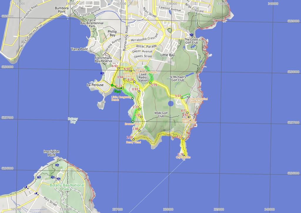
1 Cape Banks Circuit 3 hrs 7.3 km Circuit Hard track 19m This Cape Banks Circuit has a lot to offer and is thoroughly recommended. The walking travels over beaches, through coastal forest and across exposed headlands. Historically, this walk shows glimpses into the fortifications required during both World Wars. The optional side trip to the coast hospital cemetery, with over 2 graves, is worthwhile. The Cape Banks Circuit makes for a fascinating walk, both scenically and historically, and is recommended. Maps, text & images are copyright wildwalks.com Thanks to OSM, NASA and others for data used to generate some map layers. 2m Botany Bay National Park 5m

2 Little Congwong Beach Little Congwong Beach, located at La Perouse, is a sheltered sandy beach that has been described as one of the most beautiful beach oases in Sydney. Little Congwong beach has also been used for over years as an unofficial and secluded nude beach. If you see any offensive behaviour please call Crime Stoppers on or the Maroubra Police on This beach is very popular on summer weekends and has limited shade in the afternoon. More info. Browns Rock Browns Rock is a popular fishing spot at La Perouse, with an unfenced shelf of rock and concrete from which to cast fishing rods. Unfortunately, this area suffers from littering - Please help by carrying out your own rubbish and a few extra bits where safe (the rangers do a great job, but it is hard to keep up). More info. Henry Head The Henry Head Battery is located on the northern side of the entrance to Botany Bay at Henry Head. The battery was constructed on an unfenced headland between 1892 and 1895 and operated until 191 when it was closed down. The battery and observation posts was re-utilised during World War Two to defend against approaches to Botany Bay. The battery consisted of two disappearing guns, ammunition storage and observation posts. The underground bunker and tunnel complex consisted of vaulted ammunition storage rooms with double walls and ceilings. The doubling-up of walls and ceilings was a preventative measure meant to stop the walls from collapsing in the event of a direct hit. The battery is currently not in use. The white tower on the battery is the Endeavour Tower, not a lighthouse as such, but a red marker light nonetheless. More info. Cape Banks Cape Banks on the northern side of the entrance to Botany Bay, offers possibly the best view in Botany Bay National Park. From the unfenced cliff top, you can watch the power of the ocean as waves crash into the sandstone rock face below, or watch boats of all shapes and sizes, sail peacefully across the sheltered waters of the bay. If you are lucky, you can enjoy the spectacle of migrating Humpback and Southern Right whales reasonably close to shore, spouting and sometimes breaching as they make their way northward and southward in pods of three or four. The shipwreck of the SS Minmi can be seen at low tide, lying on rocks on the western side of Cape Banks. There are concrete foundations of buildings remaining on Cape Banks, from when World War Two servicemen were stationed there. More info. Before You walk Bushwalking is fun and a wonderful way to enjoy our natural places. Sometimes things go bad, with a bit of planning you can increase your chance of having an ejoyable and safer walk. Before setting off on your walk check 1) Weather Forecast (BOM Metropolitan District) 2) Fire Dangers (Greater Sydney Region) 3) Park Alerts (Botany Bay National Park) ) Research the walk to check your party has the skills, fitness and equipment required 5) Agree to stay as a group and not leave anyone to walk solo Think before you TREK The 'Think before you TREK' program developed by NSW Police & NPWS promotes the benefits of planning ahead for your bushwalking trip by using an easy to remember acronym: T R E K Take adequate supplies of food, water, navigation and first aid equipment. Register your planned route and tell friends and family when you expect to return. Emergency beacon (PLB's) should be carried on walks with significant gaps in mobile coverage (check terrain profile). Keep to your planned route and follow the map and walking trails. Topo Maps The maps provided on wildwalks are helpful, but there are times where you may need maps covering a broader area. Maps that cover this walk include; 1:25 Map Series:9133S BOTANY BAY, 9132S BONDI, 9129N PORT HACKING 1:1 Map Series:913 SYDNEY, 9129 PORT HACKING Grade This walk has been graded using the AS The overall grade of the walk is dertermined by the highest classification along the whole track. Length Time Quality of track Grade /6 Hard track 7.3 km Circuit 3 hrs Rough track, where fallen trees and other obstacles are likely (/6) Signs Minimal directional signs (/6) Experience Required Weather Infrastructure Moderate level of bushwalking experience recommended (/6) Storms may impact on navigation and safety (3/6) Limited facilities (such as cliffs not fenced, significant creeks not bridged) (/6)
3 Are you ready to have fun? Please ensure you and your group are well prepared and equipped for all possible hazards and delays. Check park closures, weather information and Fire Danger Rating before setting out. Optional side trips and alternate routes noted are not included in this walks overall grade, length or time estimate. Please allow extra time for resting and exploring areas of interest. The authors, staff and owners of wildwalks take care in preparing this information but will not accept responsibility for any inconvenience, loss or injury you may experience. Please take care, have fun - Happy Walking. Getting there You can get to Southern End of Cann Park (gps: , ) by car or bus. Car: There is free parking available. This is a circuit, so you will finish back at the start. Find up to date and more information inlcuding; travel directions, weather, park closures and walker feedback at Southern End of Cann Park (23 m mins) From the southern end of Cann Park, this walk follows the concrete track down a series of stairs, passing the 'Congwong Beach Walk' sign on your right. This walk continues gently downhill on a sandy track for about m, to find the western end of Congwong Beach. Then this walk follows the beach, with the water to your right, for about 1m until coming to a three-way intersection, with the 'Henry Head/Little Congwong Beach' sign..23 Optional sidetrip to Little Congwong Beach (31 m ) Turn right: From the eastern end of Congwong Beach, this walk follows a mostly level concrete track, passing a 'Little Congwong Beach Track' sign (on the left) and keeping the water on the right for about 23m (with coastal views on the right). Then this walk follows a sandy track moderately steeply downhill, with occasional timber steps for about 9m, until coming to the western end of Little Congwong Beach. At the end of this side trip, retrace your steps back to the main walk then Turn right..23 Little Congwong Beach Little Congwong Beach, located at La Perouse, is a sheltered sandy beach that has been described as one of the most beautiful beach oases in Sydney. Little Congwong beach has also been used for over years as an unofficial and secluded nude beach. If you see any offensive behaviour please call Crime Stoppers on or the Maroubra Police on This beach is very popular on summer weekends and has limited shade in the afternoon. More info..23 Eastern end of Congwong Beach (21 m mins) Continue straight: From the intersection, this walk follows the 'Henry Head Scenic Walk' sign and wide track gently uphill and away from the beach through coastal bush. The walk continues to follow the timber and concrete track moderately steeply uphill for about 16m, until coming to a three-way intersection with a track on the right.. Int of Henry Head Track and Congwong Beach Service (9 m 1 mins) Turn right: From the intersection, this walk follows the track slightly uphill, over a dry culverted creek and onto rock slabs. The track continues up a gentle hill through coastal forest for about 13m until coming to a three-way intersection (with a track on the left). Veer right: From the intersection, this walk follows the 'Henry Head' sign east along a wide track, gently uphill through wooded forest. This walk continues to follow the track for about 17m, until coming to a three-way intersection, with a narrow management trail and large green shed (on the left)..93 Int of Henry Head Track AND Depot Trail ( m 8 mins) Continue straight: From the intersection, this walk follows the track gently downhill for about 2m to come to a shallow, dry water course. Then this walk continues to follow the track gently uphill through moist forest for about 12m, coming to a metal ring fence (on the right). The walk follows the track moderately steeply uphill with occasional timber steps for about 26m, until coming to a four-way intersection. This intersection has a track to the left, a 'Henry Head' signed track tending right and a 'Browns Rock' signed track to the right Optional sidetrip to Browns Rock (31 m 7 mins) Turn sharp right: From the intersection, this walk follows the track gently downhill, following the 'Browns Rock 28m' sign. About 11m down the track, the walk continues down a moderately steep hill with timber steps for a further 18m, until coming to a square concrete platform on the water and Browns Rock. At the end of this side trip, retrace your steps back to the main walk then Turn sharp right Browns Rock Browns Rock is a popular fishing spot at La Perouse, with an unfenced shelf of rock and concrete from which to cast fishing rods. Unfortunately, this area suffers from littering - Please help by carrying out your own rubbish and a few extra bits where safe (the rangers do a great job, but it is hard to keep up). More info Int of Henry Head and Browns Rock Tracks (22 m mins) Turn right: From the intersection, this walk follows the wide sandy track gently uphill, past the 'Henry Head 7m' sign (on the left). After about 7m, the walk passes views of Bare Island on the right, then continues to follow the track moderately steeply uphill through low coastal forest for about 1m, until coming to a T-intersection with a management trail Int of Henry Head Track and Golf Course Management (31 m ) Turn right: From the intersection, this walk follows the wide level track south, passing the bench seat (on the right). Then this walk continues to follow the track through dense coastal bush for about 7m, until finding a World War One fort (on the right). This walk continues to follow a sandy, moderately steep downhill track for about 13m, where there are views of Bare Island on the right. This walk then continues to follow the track through dense forest for about 1m, until passing between timber posts and coming to a T-intersection, with a management trail Int of Henry Head Track and Henry Head Trail (23 m ) Turn right: From the intersection, this walk follows the wide management trail gently downhill for about 22m (ignoring side tracks), until coming to two timber seats, a white round tower and Henry Head. 2.9 Henry Head The Henry Head Battery is located on the northern side of the entrance to Botany Bay at Henry Head. The battery was constructed on an unfenced headland between 1892 and 1895 and operated until 191 when it was closed down. The battery and observation posts was re-utilised during World War Two to defend against approaches to Botany Bay. The battery consisted of two disappearing guns, ammunition storage and observation posts. The underground bunker and tunnel complex consisted of vaulted ammunition storage rooms with double walls and ceilings. The doubling-up of walls and ceilings was a preventative measure meant to stop the walls from collapsing in the event of a direct hit. The battery is currently not in use. The white tower on the battery is the Endeavour Tower, not a lighthouse as such, but a red marker light nonetheless. More info. 2.9 Henry Head (1.3 km 3 mins) Turn sharp left: From the white round tower at Henry Head, this walk follows the track east over rock slabs, with the water to the right. After about 13m, the walk then follows a narrow rocky track through coastal heath for about 13m, then descends rock steps to exposed rock platforms (with views back to Henry Head and the south coast). Then this walk continues along the narrow track, gently undulating through coastal forest for about 6m, until coming to Cruwee Cove and Shelly Beach. Turn left: From Cruwee Cove, this walk follows the beach east, with the water on your right. At the end of the beach, the walk follows initially level rock shelves, then moderately steep uphill rock shelves onto a grassy track, and comes to a golf course after about 9m. Then this walk follows a sealed footpath across the golf course for about 25m, until coming to the 'Cape Banks Aquatic Reserve' sign and Cape Banks bridge Cape Banks track (36 m ) Veer right: From the 'Cape Banks Aquatic Reserve' sign, this walk follows the track for about 2m to cross a metal foot bridge. Then this walk continues to follow the rocky track (passing a golf tee-off green on the right) for about 2m to the exposed Cape Banks headland Cape Banks Cape Banks on the northern side of the entrance to Botany Bay, offers possibly the best view in Botany Bay National Park. From the unfenced cliff top, you can watch the power of the ocean as waves crash into the sandstone rock face below, or watch boats of all shapes and sizes, sail peacefully across the sheltered waters of the bay. If you are lucky, you can enjoy the spectacle of migrating Humpback and Southern Right whales reasonably close to shore, spouting and sometimes breaching as they make their way northward and southward in pods of three or four. The shipwreck of the SS Minmi can be seen at low tide, lying on rocks on the western side of Cape Banks. There are concrete foundations of buildings remaining on Cape Banks, from when World War Two servicemen were stationed there. More info Cape Banks (36 m ) Turn around: From the Cape Banks headland, this walk follows a rocky track, for about 2m to find a metal bridge(passing a golf tee off green on the left). Then this walk continues to follow a track across the bridge and after about 2m comes to a 'Cape Banks Aquatic Reserve' sign (on the left)..12 Int of Cape Banks track & Cape Banks Management Tr (39 m 8 mins) Veer right: From the 'Cape Banks Aquatic Reserve' sign, this walk follows the grassy track gently uphill and away from the bridge, for about 15m to find the southern end of the Coastal Cemetery management trail. Then this walk follows the trail gently uphill, with the water on the right, for about m until coming to a three-way intersection with a trail (on the right)..5 Int of Cape Banks Management & Pistol Club Trail (11 m 2 mins) Veer left: From the intersection, this walk follows the wide management trail steeply uphill, away from the water. This walk continues to follow the level trail for about 35m to a T-intersection, where the walk turns right and follows a trail (with a metal ring fence on the left) for about 2m to a World War Two Bunker (on the right)..61 World War Two Bunker This World War Two bunker is at the southern end of Pistol Rd and across from the Westpac Helicopter Shed. This bunker consists of sheltered concrete ammunition storage rooms below and a circular gun base above, with surrounding coastal views.

4 .61 World War Two Bunker (1 m 2 mins) Turn left: From the World War Two bunker, this walk follows the trail towards the 'Westpac Helicopter' sign and shed. Then this walk follows the trail for about 1m, keeping the metal ring fence on the left and the concrete toilet block on the right, until coming to a locked gate and the southern end of Pistol Club Rd..71 Southern End of Pistol Club Rd (32 m ) Continue straight: From the southern end of Pistol Club Rd, this walk follows the road gently uphill away from the 'Westpac Helicopter' sign and shed, passing a sealed car park (on the left). This walk continues to follow the road, with views (on the right) of the coastal cemetery after about 2m. This walk then continues to follow the road gently downhill for about 1m, until coming to a three-way intersection, with an unsealed car park and 'Coastal Cemetery' sign (on the right). 5.3 Optional sidetrip to Coast Hospital Cemetery (15 m 2 mins) Turn right: From the intersection(which is found about 1km past the 'helicopter sign' off Henry Head Rd), this walk follow the management trail around the locked gate, passing a 'Coastal Cemetery' sign (on the right). Then this walk continues to follow the level trail for about 15m, until coming to a large four-way intersection and the Coastal Cemetery (on the right). At the end of this side trip, retrace your steps back to the main walk then Turn right. 5.3 Coast Hospital Cemetery The Coast Hospital Cemetery on the northern side of Botany Bay, was first established in the early 188 s and now houses as many as 2 graves. It serviced the Coast (Prince Henry) Hospital, originally a smallpox hospital, as people who died of smallpox were required to be buried at the hospital grounds. The hospital was built far enough from the city to provide quarantine, and for this reason, the hospital in time became an infectious deseases hospital, also treating patients with influenza, bubonic plague, typhoid fever and leprosy. Unfortunately, the cemetery has now fallen into disrepair and many of the grave sites are in poor condition. 5.3 Int of Pistol Club Rd and Coast Hospital Cemetery (76 m 13 mins) Continue straight: From the intersection, this walk follows the level road west, with golf courses on the left and right (ignoring side roads) for about 8m, until coming to a gentle uphill and three-way intersection, with a 'Jennifer Street Boardwalk' sign and track (on the right) Optional sidetrip to Int of Jennifer Street Boardw (37 m ) Turn right: From the intersection, this walk follows a concrete footpath for about 15m, passing the 'Jennifer Street Boardwalk' sign (on the right). Then this walk continues along the raised timber boardwalk, initially gently uphill then a little more steeply through low forest. After about 3m, the walk finds an 'Eastern Suburbs Banksia Scrub' sign and shelter (on the left), then continues along a level concrete footpath for about 25m, coming to Jennifer Street. At the end of this side trip, retrace your steps back to the main walk then Turn right Int of Pistol Club Rd AND Jennifer Street Boardwal (5 m 7 mins) Continue straight: From the intersection, this walk follows the road gently uphill for about 15m. Then this walk continues to follow the road gently downhill for about 6m, then turns right at a T-intersection. The walk follows the sealed road for about 5m, until coming to a three-way intersection with a trail and 'LaPerouse Works Depot' sign (on the left). Veer right: From the intersection, this walk follows the road gently uphill and directly away from the face of the 'LaPerouse Works Depot' sign for about 2m, until coming to a speed bump and four-way intersection, where a track crosses the road. 6.2 Int of Henry Head Lane AND Henry Head Track (26 m ) Turn right: From the intersection, this walk follows the track gently uphill (passing between timber posts) through coastal forest. After about 18m, the walk comes to an exposed rock platform and the Henry Head view point. 6.5 Henry Head Viewpoint The Henry Head view point is located above Henry Head Lane and offers good views on the surrounding coastline. From the unfenced sandstone platform, good views are available to the west, south and east, including Bare Island, the Barracks Tower and Henry Head. 6.5 Henry Head Viewpoint ( m 8 mins) Turn right: From the Henry Head view point, this walk follows the level rocky track north and directly away from the viewpoint (ignoring sidetracks). After about 15m, the track starts to head gently downhill, and then after about 1m, the sandy track becomes steeper with timber steps. After a further 17m, the walk finds a four-way intersection, with timber posts and a sealed road (Henry Head Lane). This walk crosses the road and continues along the unmarked track gently downhill and across a timber bridge over a creek. Then the walk continues moderately steeply uphill, until coming to 'The Happy Valley' sign and Anzac Parade Int of Anzac Parade AND Henry Head Track (37 m ) Turn left: From the car park and grassed park, this walk follows the footpath south, with Anzac Parade on your right. Approximately 3m along footpath (the footpath briefly separates from the road and then returns), the walk finds the northern end of Cann Park and 'Cann Park' sign. This walk then follows the footpath towards the coast (and past the snake pit) for about 1m, until coming to the southern end of Cann Park and 'Congwong Beach Walk' sign Jennifer Street Boardwalk Jennifers Boardwalk allows elevated access through a rare and endangered ecological community known as the Eastern Suburbs Banksia Scrub. This community of native plants is protected under the Threatened Species Conservation Act. These Banksia once occupied around 5,3 hectares of land between North Head and Botany Bay in Sydney s eastern suburbs. Currently, surviving stands totalling approximately 16 hectares have been recorded by the local government areas of Botany, Randwick, Waverley, and Manly. More info.
5
6 Summary navigation sheet for the Cape Banks Circuit km From Up/Dwn Length Initial directions (Use full tracknotes and maps for more detail) Start Southern End of Cann Park , (GR Botany Bay, ) m mins From the southern end of Cann Park, this walk follows the concrete track down a series of stairs, passing the 'Congwong Beach Walk' sign on your right..23 Eastern end of Congwong Beach , (GR Botany Bay, ) m Optional sidetrip to Little Congwong Beach. Turn right: From the eastern end of Congwong Beach, this walk follows a mostly level concrete track, passing a 'Little Congwong Beach Track' sign (on the left) and keeping the water on the right for about 23m (with Eastern end of Congwong Beach , (GR Botany Bay, ) 1 21 m mins Continue straight: From the intersection, this walk follows the 'Henry Head Scenic Walk' sign and wide track gently uphill and away from the beach through coastal bush.. Int of Henry Head Track and Congwong Beach Servicetrail , (GR Botany Bay, ) m 1 mins Turn right: From the intersection, this walk follows the track slightly uphill, over a dry culverted creek and onto rock slabs..93 Int of Henry Head Track AND Depot Trail , (GR Botany Bay, 37376) 17-7 m 8 mins Continue straight: From the intersection, this walk follows the track gently downhill for about 2m to come to a shallow, dry water course Int of Henry Head and Browns Rock Tracks , (GR Botany Bay, 37372) m 7 mins Optional sidetrip to Browns Rock. Turn sharp right: From the intersection, this walk follows the track gently downhill, following the 'Browns Rock 28m' sign Int of Henry Head and Browns Rock Tracks , (GR Botany Bay, 37372) m mins Turn right: From the intersection, this walk follows the wide sandy track gently uphill, past the 'Henry Head 7m' sign (on the left) Int of Henry Head Track and Golf Course Management Trail , (GR Botany Bay, 37371) m Turn right: From the intersection, this walk follows the wide level track south, passing the bench seat (on the right) Int of Henry Head Track and Henry Head Trail , (GR Botany Bay, 37368) m Turn right: From the intersection, this walk follows the wide management trail gently downhill for about 22m (ignoring side tracks), until coming to two timber seats, a white round tower and Henry Head. 2.9 Henry Head , (GR Botany Bay, ) km 3 mins Turn sharp left: From the white round tower at Henry Head, this walk follows the track east over rock slabs, with the water to the right Cape Banks track , (GR Botany Bay, ) 36 m Veer right: From the 'Cape Banks Aquatic Reserve' sign, this walk follows the track for about 2m to cross a metal foot bridge Cape Banks -3.12, (GR Port Hacking, ) 36 m Turn around: From the Cape Banks headland, this walk follows a rocky track, for about 2m to find a metal bridge(passing a golf tee off green on the left)..12 Int of Cape Banks track & Cape Banks Management Trail , (GR Botany Bay, ) m 8 mins Veer right: From the 'Cape Banks Aquatic Reserve' sign, this walk follows the grassy track gently uphill and away from the bridge, for about 15m to find the southern end of the Coastal Cemetery management trail..5 Int of Cape Banks Management & Pistol Club Trail , (GR Bondi, 3837) 2 11 m 2 mins Veer left: From the intersection, this walk follows the wide management trail steeply uphill, away from the water..61 World War Two Bunker , (GR Bondi, 38371) 6 1 m 2 mins Turn left: From the World War Two bunker, this walk follows the trail towards the 'Westpac Helicopter' sign and shed..71 Southern End of Pistol Club Rd , (GR Botany Bay, ) m Continue straight: From the southern end of Pistol Club Rd, this walk follows the road gently uphill away from the 'Westpac Helicopter' sign and shed, passing a sealed car park (on the left). 5.3 Int of Pistol Club Rd AND Coastal Cemetery Trail , (GR Botany Bay, ) m 2 mins Optional sidetrip to Coast Hospital Cemetery. Turn right: From the intersection(which is found about 1km past the 'helicopter sign' off Henry Head Rd), this walk follow the management trail around the locked gate, passing a 'Coastal Cemetery' sign (on the right).
7 Powered by TCPDF ( Summary navigation sheet for the Cape Banks Circuit km From Up/Dwn Length Initial directions (Use full tracknotes and maps for more detail) 5.3 Int of Pistol Club Rd and Coast Hospital Cemetery Management Trail , (GR Botany Bay, ) m 13 mins Continue straight: From the intersection, this walk follows the level road west, with golf courses on the left and right (ignoring side roads) for about 8m, until coming to a gentle uphill and three-way intersecti Int of Pistol Club Rd & Jennifer Street Boardwalk , (GR Botany Bay, ) 6 37 m Optional sidetrip to Int of Jennifer Street Boardwalk & Jennifer Street. Turn right: From the intersection, this walk follows a concrete footpath for about 15m, passing the 'Jennifer Street Boardwalk' sign (on the right) Int of Pistol Club Rd AND Jennifer Street Boardwalk , (GR Botany Bay, ) m 7 mins Continue straight: From the intersection, this walk follows the road gently uphill for about 15m. 6.2 Int of Henry Head Lane AND Henry Head Track , (GR Botany Bay, ) m Turn right: From the intersection, this walk follows the track gently uphill (passing between timber posts) through coastal forest. 6.5 Henry Head Viewpoint , (GR Botany Bay, 37238) 5-26 m 8 mins Turn right: From the Henry Head view point, this walk follows the level rocky track north and directly away from the viewpoint (ignoring sidetracks) Int of Anzac Parade AND Henry Head Track , (GR Botany Bay, 3738) 1 37 m Turn left: From the car park and grassed park, this walk follows the footpath south, with Anzac Parade on your right.
Echo Point to Leura Forest via Three Sisters and Giant Stairs loop
 Echo Point to Leura Forest via Three Sisters and Giant Stairs loop 3 hrs 3.8 km Circuit Hard track 512m This walk starts from the popular Echo Point, in Katoomba, and winds down to the base of the Three
Wallarah Coastal Walk
 Wallarah Coastal Walk 3 hrs 8.3 km Return Hard track 247m This walk starts at Caves Beach and travels south along the coastline, until reaching the Pinney s Headland Lookout. There are many opportunities
The Foreshore Walk. 24m. 1m Lake Macquarie LGA. 1 hr 15 mins 2.9 km One way. Hard track 81m
 The Foreshore Walk 1 hr 15 mins 2.9 km One way Hard track 81m This walk traverses the coastline of the Green Point reserve. By following a variety of tracks and occasionally traveling inland through eucalyptus
Currie Rd to Davidson Park
 Currie Rd to Davidson Park 3 hrs 7.2 km One way Moderate track 28m Starting at Currie Rd in Forestville, this walk follows Middle Harbour to Davidson Park, under Roseville Bridge. There are two optional
Wattamolla to Big Marley Beach
 Wattamolla to Big Marley Beach 4 hrs 10.4 km Circuit Moderate track 4m This walk is an excellent loop which takes in both the coast and the heathy inland of Royal National Park. Nearly the whole walk has
Morgans Creek to Padstow
 Morgans Creek to Padstow 2 hrs 45 mins 8 km One way Moderate track 3 144m This pleasant walk starts from the Morgans Creek park, at Henry Lawsons Drive, and follows the Georges River past the Boomerang
Hunters Hill to Epping Road
 Hunters Hill to Epping Road 2 hrs 30 mins 5.5 km One way Moderate track 154m An enjoyable walk through lower sections of the Lane Cove National Park, this walk features plenty of mangroves next to the
Waterfall to Heathcote
 Waterfall to Heathcote 5 hrs Hard track 10.8 km One way 4 467m This walk explores the heart of Heathcote National Park, and is easily accessed with a train station at either end. Although relatively close
Wentworth Falls Conservation Hut Loop
 Wentworth Falls Conservation Hut Loop 3 hrs Hard track 6.7 km Circuit 4 341m This scenic walk from Wentworth Falls Station, winds along the Nature Trail to Conservation Hut, then drops into the magnificent
Campbell Drive to Snapper Point
 Campbell Drive to Snapper Point 1 hr 45 mins 4.2 km One way Experienced only 135m This walk follows the Coast Track to Frazer Beach, along the Geebung and (overgrown) Grass Tree Tracks. From the northern
Carrington Park to Leura Forest and pass loop
 Carrington Park to Leura Forest and pass loop 3 hrs Hard track 4.8 km Circuit 4 674m This walk is a fantastic way to see Leura Forest. The walk descends from Carrington Park, visiting Leura Forest and
Heathcote to Engadine via Audley
 Heathcote to Engadine via Audley 6 hrs 3 mins 5 km One way Hard track 4 635m Covering a large section of central Royal National Park, this walk goes through the heath and scrub along a well managed and
Sid Pulsford Walk. 175m. 33m. 1 hr 45 mins 4.1 km One way. Hard track 118m. Gosford LGA
 Sid Pulsford Walk 1 hr 5 mins.1 km One way Hard track 118m Sid Pulsford Walk explores the ridge top of Kincumber Mountain, from Honeman's Rock to Green Point. The walk mostly follows wide management trails.
Govetts Leap Loop. 1065m. 909m Blue Mountains National Park. 4 hrs 30 mins 8.7 km Circuit. Hard track 380m
 Govetts Leap Loop 4 hrs 30 mins 8.7 km Circuit Hard track 380m This walk, from Blackheath Train Station, is a fantastic way to see some of the iconic areas of the Blue Mountains in the Blackheath area.
Epping to Pennant Hills Station (via Lane Cove River)
") Epping to Pennant Hills Station (via Lane Cove River) 3 hrs 5 mins 8.4 km One way Hard track 249m This walk, from Epping to Pennant Hills Station, is a great way to see the upper Lane Cove River Valley.
Epping to Pennant Hills Station (via Lane Cove River) 3 hrs 5 mins 8.4 km One way Hard track 249m This walk, from Epping to Pennant Hills Station, is a great way to see the upper Lane Cove River Valley.
Epping to Eastwood Station (via Lane Cove River)
") Epping to Eastwood Station (via Lane Cove River) hrs 45 mins 10.2 km One way Moderate track 189m Epping to Eastwood, via Lane Cove River, is the longer route through the bush between the stations. This
Epping to Eastwood Station (via Lane Cove River) hrs 45 mins 10.2 km One way Moderate track 189m Epping to Eastwood, via Lane Cove River, is the longer route through the bush between the stations. This
Popes Glen, Pulpit Rock, Govetts Leap and Braeside Walk
 Popes Glen, Pulpit Rock, Govetts Leap and Braeside Walk 8 hrs Hard track 13.6 km Circuit 4 1068m This large circuit walk, from Popes Glen to Pulpit Rock, Govetts leap and along the Braeside Track, passes
Hornsby Blue Gum Walk
 Hornsby Blue Gum Walk 3 hrs Hard track 6.7 km Circuit 4 374m This delightful loop is one of the prettiest and most popular walks in the Hornsby area. Going from an environment of ferns and clear bushland
Balmoral Beach to The Spit
 Balmoral Beach to The Spit 2 hrs 30 mins.3 km One way Hard track 85m This walks follows the coast from Balmoral to the Spit and across Spit Bridge. There are some alternate tracks to consider at high-tides,
Katoomba Falls Circuit
 Katoomba Falls Circuit hr 5 mins.5 km Circuit Hard track 59m For those looking for a walk involving more than simple boardwalk, this trail winding through the temperate rain forest could be just the thing.
Little Digger Track. 68m. 1 Hr 2.2 km One way. Moderate track 93m. Moores Creek Reserve
 Little Digger Track Hr 2.2 km One way Moderate track 93m This walk follows Moores Creek through several reserves in east Roseville and East Lindfield. The track is named after Australia's 7th Prime Minster,
Green Point Circuit Walk
 Green Point Circuit Walk 3 hrs 7.7 km Circuit Hard track 269m This walk visits all of the popular locations in Green Point Reserve, as well as some of the lesser-visited areas inland. Taking in Sea Eagle
Little Digger Track to Davidson Reserve and Lyrebird Circuit
 Little Digger Track to Davidson Reserve and Lyrebird Circuit 4 hrs 3 mins 11.5 km One way Hard track 4 47m Exploring both the eastern and western sides of Middle Harbour Creek, this walk follows the Little
Rail to River Walk. 3 hrs. Hard track 7.5 km Circuit. 222m
 Rail to River Walk 3 hrs Hard track 7.5 km Circuit 4 222m This walk is a great one from Chatswood Station to the Lane Cove River National Park. The walk descends through the vegetated bushland which fills
Spit Bridge to Middle Head Forts
 Spit Bridge to Middle Head Forts 2 hrs 30 mins 6.3 km One way Hard track 4 181m This scenic walk takes you from the Spit Bridge, along the coast to explore the Middle Head Forts. There are a few alternate
The Basin Track and Mackerel Track
 The Basin Track and Mackerel Track 3 hrs 5.9 km Circuit Hard track 226m This walk is a great way to see some popular areas in Ku-ring-gai Chase National Park. The walk from West Head Rd travels to The
Teralba to Charlestown Park track head
 Teralba to Charlestown Park track head 4 hrs 30 mins 13.3 km One way Moderate track 3 220m This section of the Great North Walk starts from the Teralba train station and winds down and around the edge
Mackerel Beach, West Head Loop
 Mackerel Beach, West Head Loop 5 hrs 8.6 km Circuit Hard track 422m The Mackerel Beach, West Head Loop is a walk which explores a large part of the West Head. The journey starts and finishes with a ferry
Dead Horse Gap Loop track
 Dead Horse Gap Loop track 4 hrs 30 mins Hard track 9.8 km Circuit 144m 4 This walk starts with a ride up the Kosciuszko Express Chairlift. There is an opportunity to eat at Australia's highest restaurant,
Berowra to Mt Kuring-gai
 Berowra to Mt Kuring-gai 4 hrs 30 mins 9.4 km One way Hard track 4 551m From the ridges above Cowan Creek, this walk takes in some great lookouts (especially around Mt Kuringgai) as well as enjoying an
Bouddi Coastal Walk. 5 hrs. Hard track 8.1 km One way. 364m
 Bouddi Coastal Walk 5 hrs Hard track 8.1 km One way 4 364m This is one of the longer walks in the Bouddi National Park and it is rich in scenery. The walk follows the coastline with many side trips to
Sphinx, Warrimoo and Bobbin Head tracks
 Sphinx, Warrimoo and Bobbin Head tracks 4 hrs 9.6 km Circuit Moderate track 499m This great walk starts at the Sphinx Memorial and loops around via Cowan Creek, exploring diverse environments as it changes
Rail to River and Stringybark Creek Reserve Walk
 Rail to River and Stringybark Creek Reserve Walk 4 hrs Hard track 11.2 km Circuit 4 302m This walk begins in the busy city of Chatswood and soon enters the nearby bushland around the Lane Cove River. The
Callicoma Loop. 174m. 98m. 2 hrs. Hard track 5.1 km Circuit. 153m
 Callicoma Loop 2 hrs Hard track 5.1 km Circuit 153m This great circuit walk passes through some really nice forest around the fringe of Cherrybrook. Highlights of the walk include some beautiful rock overhangs
Mackerel Beach and Resolute Loop
 Mackerel Beach and Resolute Loop 3 hrs 5.4 km Circuit Hard track 384m This walk is another great walk in Ku-ring-gai Chase National Park, accessed by ferry. From the Mackerel Beach wharf, this walk uses
Patonga to Woy Woy. 5 hrs 45 mins 15.5 km One way. Hard track. 497m
 Patonga to Woy Woy 5 hrs 45 mins 15.5 km One way Hard track 4 497m This walk explores a variety of environments from the shore line and coastal cliffs near Patonga, to the dry, rocky and open ridge line.
Scenic World to Echo Point
 Scenic World to Echo Point 1 hr 15 mins 2.1 km One way Moderate track 192m This is one of the most popular tourist walks in the Katoomba area. The walk follows the cliffs along a well maintained and signposted
De Burgs Bridge to Thornleigh station
 De Burgs Bridge to Thornleigh station 3 hrs 45 mins 9.7 km One way Hard track 4 363m This walk follows a section of the Great North Walk, starting from De Burghs bridge. The walk winds north west, through
De Burghs Bridge to Fullers Bridge
 De Burghs Bridge to Fullers Bridge 2 hrs 3 mins Hard track 6 km One way 2m 4 Following the Lane Cove River, this walk mostly follows a section of the Great North Walk and is well maintained and signposted.
Middle Harbour Creek Loop
 Middle Harbour Creek Loop 5 hrs 45 mins 15.1 km Circuit Experienced only 5 570m This walk explores the upper reaches of Middle Harbour Creek, starting and ending at the great parklands at Davidson Park,
Under and Over Cliff Walk
 Under and Over Cliff Walk 4 hrs 9.4 km Circuit Moderate track 576m This walk from Wentworth Falls Station is a fantastic way to see a large majority of the Wentworth Falls cliffline. The track winds under
Dubbo Gully and Ten Mile Hollow Circuit (via Clares Bridge)
") Dubbo Gully and Ten Mile Hollow Circuit (via Clares Bridge) 2 Days Hard track 24.3 km Circuit 4 1117m This two day (or ten hour) walk follows several historic roads, now closed to traffic. Starting with
Dubbo Gully and Ten Mile Hollow Circuit (via Clares Bridge) 2 Days Hard track 24.3 km Circuit 4 1117m This two day (or ten hour) walk follows several historic roads, now closed to traffic. Starting with
Epping to Gordon Station
 Epping to Gordon Station 4 hrs 15 mins 11.7 km One way Hard track 4 365m This walk, from Epping Station to Gordon Station, passes below the homes which sit on the hills high above the Lane Cove River.
Upper Rumbalara circuit
 Upper Rumbalara circuit 1 hr 30 mins 3.3 km Circuit Hard track 176m A great circuit walk, covering most of the walking tracks and sights in the upper section of the Rumbalara Reserve. There is some really
Taronga Wharf to Chowder Bay
 Taronga Wharf to Chowder Bay 2 hrs 4.4 km One way Moderate track 246m Starting at Taronga Wharf, this walk passes many icons of Sydney, including Taronga Zoo, HMAS Sydney Mast, Chowder Bay. The walk also
National Pass from Wentworth Falls to Conservation Hut
 National Pass from Wentworth Falls to Conservation Hut 3 hrs Hard track 3.6 km One way 739m Starting at Wentworth Falls picnic area, this scenic and historic walk explores many waterfalls, lookouts and
Woolwich Wharf to Boronia Park
 Woolwich Wharf to Boronia Park 2 hrs 5.8 km One way Moderate track 175m Going through the streets of Hunters Hill, this walk is on the first segment of the Great North Walk. The majority of the walk is
Wentworth Falls Station Loop (Undercliff Walk)
") Wentworth Falls Station Loop (Undercliff Walk) 4 hrs 3 mins Hard track 8.9 km Circuit 658m 4 This walk passes some stunning waterfalls and views into the Jamison Valley, following the cliff edges around
Wentworth Falls Station Loop (Undercliff Walk) 4 hrs 3 mins Hard track 8.9 km Circuit 658m 4 This walk passes some stunning waterfalls and views into the Jamison Valley, following the cliff edges around
Hermitage Foreshore Track
 Hermitage Foreshore Track 1 Hr 2.2 km One way Moderate track 123m The Hermitage Foreshore Walk is a wonderful way to explore Sydney Harbour from the perspective of South Head. This walk starts from Nielsen
Federal Pass Walking Track
 Federal Pass Walking Track 5 hrs Hard track 8 km One way 4 989m This classic trail follows along the base of the cliffs from Leura to the Golden Stairs, passing many of the more popular sights of the Katoomba
Blackheath Station to Junction Rock Loop (via Grand Canyon and Popes
 Blackheath Station to Junction Rock Loop (via Grand Canyon and Popes 8 hrs 30 mins 18.2 km Circuit Hard track 4 1254m This circuit starts in Blackheath and heads down into the Grand Canyon and Rodriguez
Echo Point to Leura Forest Circuit
 Echo Point to Leura Forest Circuit 3 hrs 4.8 km Circuit Hard track 588m Forming a circuit around the cliffs and then the valley floor, this is a walk more then capable of convincing a walker of the beauty
Glenbrook and Euroka Circuit
 Glenbrook and Euroka Circuit 2 Days 16.6 km Circuit Experienced only 790m This two day circuit, returning to Glenbrook Station, is a scenic walk which passes many of the tourist attractions within the
Wentworth Falls Station Loop
 Wentworth Falls Station Loop 5 hrs 3 mins 9.5 km Circuit Hard track 4 13m The Wentworth Falls Station Loop takes in most of the upper tracks around Wentworth Falls. There are many scenic views near the
Thornleigh to Hornsby
 Thornleigh to Hornsby 4 hrs Hard track 10.2 km One way 4 526m Starting at Thornleigh station you walk through suburban streets for a short while before diving into the bush at the southern end of Berowra
Roseville to Macquarie Park
 Roseville to Macquarie Park 3 hrs 3 mins 8.8 km One way Hard track 4 29m This walk starts at Roseville station and explores the streets and alleyways of Roseville before joining the main spine of the Great
North Ryde Fairyland circuit
 North Ryde Fairyland circuit 2 hrs 30 mins Hard track 6.9 km Circuit 193m 4 Starting at North Ryde train station this walk explores a stretch of the Lane Cove River, visiting the historic Fairlylands Pleasure
Charlestown Park trackhead to Newcastle station
 Charlestown Park trackhead to Newcastle station 5 hrs 30 mins 12.1 km One way Hard track 4 287m This section of the Great North Walk starts from the Charleston Park track head and winds through the streets
Gordon to Chatswood Station
 Gordon to Chatswood Station 4 hrs 30 mins 12.2 km One way Hard track 4 381m This walk is a great way to get into the bush without being far from civilisation. The walk wanders through untouched valleys
Lane Cove Tourist Park River Circuit
 Lane Cove Tourist Park River Circuit 5 hrs 12 km Circuit Hard track 383m This walk follows a large section of Lane Cove River. The walk follows the Riverside Walking track up the Lane Cove River to De
Spit Bridge to Manly (Manly Scenic Walkway)
") Spit Bridge to Manly (Manly Scenic Walkway) 3 hrs 45 mins 9.1 km One way Moderate track 349m The Spit to Manly walk is a classic bushwalk on Sydney's Northern Beaches. The walk follows a well-maintained
Spit Bridge to Manly (Manly Scenic Walkway) 3 hrs 45 mins 9.1 km One way Moderate track 349m The Spit to Manly walk is a classic bushwalk on Sydney's Northern Beaches. The walk follows a well-maintained
The Coast Track. 2 Days. Hard track 27.4 km One way. 1351m
 The Coast Track 2 Days Hard track 27.4 km One way 4 1351m Heading south, this walk covers the coastline of the Royal National Park and can truly only be described as amazing. With breathtaking coastal
Wentworth Falls Loop. 893m. 665m. 6 hrs 10.2 km Circuit. Hard track 1093m. Blue Mountains National Park
 Wentworth Falls Loop 6 hrs 1.2 km Circuit Hard track 193m This is a great walk, both in size and spectacular views. The walk makes its way from Wentworth Falls train station and drops off the plateau,
Bouddi Ridge and Coastal Walk
 Bouddi Ridge and Coastal Walk 2 Days Hard track 27 km Circuit 4 126m This overnight walk takes in the majority of the magnificent Bouddi National Park. The walk starts from the pleasant Putty Beach camping
Sphinx to Mt Kuring-gai
 Sphinx to Mt Kuring-gai 4 hrs 45 mins 1.7 km One way Hard track 673m This walk starts at the Sphinx War Memorial and follows some well maintained and popular walking tracks down to Cowan Creek. Enjoy the
Rumbalara Explorer. 158m. 5m Rumbalara Reserve. 2 hrs 45 mins 6.1 km Circuit. Hard track 326m
 Rumbalara Explorer 2 hrs 5 mins 6.1 km Circuit Hard track 326m Pretty well the grand tour of the Rumbalara Reserve, this walk takes in much of the great scenery the reserve has to offer. The walk covers
Faulconbridge to Blaxland
 Faulconbridge to Blaxland 2 Days Experienced only 15.2 km One way 5 693m This two-day walk, or very solid one-day walk, takes you from station to station, through lush, scenic forest in the lower Blue
Scenic world to Three Sisters Loop via Furber Steps
 Scenic world to Three Sisters Loop via Furber Steps 5 hrs 5.8 km Circuit Hard track 722m This walk starts from the popular Scenic World, in Katoomba, and winds down the Furber steps into the Jamison Valley,
Gosford to Lisarow. 202m
 Gosford to Lisarow 4 hrs 3 mins Hard track 11.3 km One way 4 479m This walk is a great way to explore the ridge-top bushland between Gosford and Lisarow. Passing through Rumbalara and Katandra Reserves,
Bobbin Head Loop. 166m. 0m Ku-ring-gai Chase National Park. 5 hrs 12.9 km Circuit. Hard track 619m
 Bobbin Head Loop 5 hrs 12.9 km Circuit Hard track 619m This great circuit walk enjoys a variety of landscapes in Ku-ring-gai Chase National Park. The walk starts at the historic Sphinx war memorial and
Narrabeen Lagoon Trail (from Middle Creek)
") Narrabeen Lagoon Trail (from Middle Creek) 2 hrs 30 mins 8.6 km Circuit Very easy 1 105m The Narrabeen Lagoon Trail is a wonderful and accessible walk on the Northern Beaches of Sydney. The trail is used
Narrabeen Lagoon Trail (from Middle Creek) 2 hrs 30 mins 8.6 km Circuit Very easy 1 105m The Narrabeen Lagoon Trail is a wonderful and accessible walk on the Northern Beaches of Sydney. The trail is used
Manly to Seaforth Oval
 Manly to Seaforth Oval 5 hrs 45 mins 13.7 km One way Moderate track 3 624m This walk follows the Manly to Spit Scenic Walkway, then continues past The Spit Bridge to Seaforth Oval. The walk provides magnificent
Light to Light Walk 2 days
 Light to Light Walk 2 days 2 Days Hard track 3.9 km One way 4 794m Over two days, this classic walk explores the coast from Boyd Tower to the Green Cape Lighthouse in the south. Hegartys Bay Camp is over
Chatswood to Epping Station
 Chatswood to Epping Station 6 hrs Hard track 16.3 km One way 4 533m This walk, from Chatswood to Epping, is a long but enjoyable walk along the Lane Cove valley. The walk mostly follows the Lane Cove River
Taronga Zoo to Spit Bridge
 Taronga Zoo to Spit Bridge 5 hrs Hard track 1.4 km One way 4 41m This is a scenic and culturally rich walk with views over Sydney Harbour and many interesting heritage buildings along the way. The start
Six Foot Track. 1212m
 Six Foot Track 3 Days 44.8 km One way Hard track 4 2066m This classic walk takes you from Katoomba to Jenolan Caves via a historic horse route. The walk travels mainly along well-maintained service tracks
Sydney to Thornleigh via Lane Cove Tourist Park
 Sydney to Thornleigh via Lane Cove Tourist Park 2 Days 33 km One way Hard track 4 1114m This overnight walk starts from the Obelisk in Macquarie Park, Sydney, at the official start of the Great North Walk.
Start / Finish. Version 2
 Start / Finish Version 2 Gosford (Start) to Woy Woy Head South down Etna Street, crossing Henry Parry Drive, then Mann St, Gosford, where Etna St becomes Racecourse Road. Follow this road all the way
Cleeve Common Self-Guided Walk 1 Family Circular
 Cleeve Common Self-Guided Walk 1 Family Circular Start point: Quarry Car Park Nearest postcode: GL52 3PW please note this is for the golf club. To find the quarry car park drive past the golf club car
SELF GUIDED TOURING ROUTE
 SELF GUIDED TOURING ROUTE Things to see and places to go on the loop from Orbost to Marlo, Cape Conran, Cabbage Tree and back to Orbost (or onwards to Cann River) V6 April 2017 This guide should be read
ULTRA-TRAIL AUSTRALIA May 2018 COURSE DESCRIPTION AND COURSE NOTES
 ULTRA-TRAIL AUSTRALIA 100 19-20 May 2018 COURSE DESCRIPTION AND COURSE NOTES LEG 1 Scenic World (Start) to Narrow Neck (Checkpoint 1) Course Description: From the start, at the front entrance of Scenic
Harbour Bridge to Taronga Zoo
 Harbour Bridge to Taronga Zoo 4 hrs 9.8 km One way Moderate track 389m On this walk, you will explore much of the foreshore linking Milsons Point Station to Taronga Zoo Ferry wharf. The walk is mostly
THE WELLDIGGERS ARMS, HESWORTH AND FITTLEWORTH TRAIL
 THE WELLDIGGERS ARMS, HESWORTH AND FITTLEWORTH TRAIL 5.5 miles Circular 3 hours 041017 Challenging Terrain A 300-year-old pub turned country-inn on the edge of the South Downs National Park, The Welldiggers
Directions for Day 1: Colwood To Metchosin
 Colwood-Metchosin Page 1 of 8 Directions for Day 1: Colwood To Metchosin Start: Royal Roads University, Birds of a Feather B&B, or at Esquimalt Lagoon Finish: Your accommodation in Metchosin Time: 4-5
10 Miles Circular 5 hours
 VISIT RYEDALE PICKERING AND CAWTHORN CAMPS 10 Miles Circular 5 hours Moderate Terrain 120616 A 10 mile (16km) there and back walk from the market town of Pickering in Ryedale. The route heads north through
NEWLANDS CORNER AND ST MARTHAS
 NEWLANDS CORNER AND ST MARTHAS 10k CIRCULAR ROUTE 2½-3HRS GU4 8SE From Newlands Corner on the North Downs just outside Guildford, you can enjoy one of the most beautiful panoramas of quintessential English
BEACH ACCESS INVENTORY 2014 Electoral Area A
 BEACH ACCESS INVENTORY 2014 Electoral Area A Site Inventory and report compiled by the Electoral Area A Parks, Recreation and Culture Commission members: Alec McPherson, Andrew Thornton, Angela Vincent,
Detailed Descriptions and Maps of Woodside s Nature Trails
 Detailed Descriptions and Maps of Woodside s Nature Trails Access Mill Road Trail Park along Anderson Mill road. Signs on West Pleasant Colony and Anderson Mill road clearly point to the beginning of the
LDWA SOUTH DOWNS MARATHON 13 th MAY 2018
 AHD ahead SDW South Downs Way BL/BR bear left/bear right TL/TR turn left/turn right X cross LEG 1 - EAST DEAN to WP1 NORTON GR 470019. Open 1030 to 1300. 9.7 miles. 1.1 From village hall TL and walk to
VERN S CAMP from Minginui
 VERN S CAMP from Minginui Map: Kuratau, 1:50,000 V18 Refer Figures 1, 3, 4 and 5 GPS: Geodetic Datum 1949 Refer Figure 10a (Geographic) and 10b (NZ Grid) How to get to START: From the police station on
LDWA SOUTH DOWNS MARATHON
 AHD ahead SDW South Downs Way BL/BR bear left/bear right TL/TR turn left/turn right SP signpost/fingerpost X cross LEG 1 - EAST DEAN to WP1 NORTON GR 470019. Open 1030 to 1300. 9.6 miles. 1.1 From village
Approximate distance: 5.5 miles For this walk we ve included OS grid references should you wish to use them. Start. End
 Approximate distance: 5.5 miles For this walk we ve included OS grid references should you wish to use them. End 4 1 Start 3 2 N W E S Reproduced by permission of Ordnance Survey on behalf of HMSO. Crown
Masson Hill. Walk. Approximately 4 km. Moderate Walk Begins from Matlock Railway Station
 Masson Hill Walk Approximately 4 km Moderate Walk Begins from Matlock Railway Station TOWN WALKS Masson Hill walk is approx. 4 km. It can be walked in a couple of hours or so. Enjoy your walk and the beautiful
Beautiful Walks from the Blue Ball Inn
 Walk No. 7 COAST AND VALLEY WALK Countisbury, Glenthorne, County Gate, Brendon, Rockford and Wilsham 10 MILES APPROX. Walking time 5 hours approx. (not including breaks)> OS Sheet 64/74 Lynton and Lynmouth.
The Year Of Mercy Pilgrimage Sts Peter and Paul s Church, Bulimba To The Cathedral of St Stephen
 The Year Of Mercy Pilgrimage Sts Peter and Paul s Church, Bulimba To The Cathedral of St Stephen Dist Route Photos Photos 0.0km St Peter and Paul s Church, 235 Riding Rd & Cnr Main Ave, Balmoral. http://www.bulimbacatholic.com/
Chapel Point to Anderby Creek
 Coastal Country Park Walks Chapel Point to Anderby Creek A CIRCULAR WALK OF 8.5 OR 6 KM (5.3 OR 3.75 MILES) INTRODUCTION The Lincolnshire Coastal Country Park lies between Sandilands, Chapel St Leonards
Murlough. Dunes open access, some restricted areas Woodland open access, some restricted areas
 A2 Belfast Road Dundrum Murlough P3 N Dundrum Bay boathouse Ballykinler MOD Firing Range P4 P5 Downshire Bridge inlet floods at high tide Murlough Farm Private PNT Murlough House Private Seals agricultural
Hammer Vale and Linchmere Common
 point your feet on a new path Hammer Vale and Linchmere Common Distance: 9 km=5½ miles or 6 km=3¾ miles easy walking with one steep section Region: Hampshire, West Sussex Author: Botafuego Refreshments:
Walk 7: Watchet to washford
 Walk 7: Watchet to washford Length: Moderate - 7.5 miles / 12 km Good For: Theme: History Duration: 2-3 hours depending on speed of walking Notes: This is a moderate to difficult walk in places, with steps,
Dorridge & District Residents Association A Walk Along The Green Belt From Dorridge to Catherine-de-Barnes
 Dorridge & District Residents Association A Walk Along The Green Belt From Dorridge to Carine-de-Barnes The starting section of this walk through open fields would be destroyed by building of motorway