Little Digger Track. 68m. 1 Hr 2.2 km One way. Moderate track 93m. Moores Creek Reserve
|
|
|
- Hope Willis
- 5 years ago
- Views:
Transcription


1 Little Digger Track Hr 2.2 km One way Moderate track 93m This walk follows Moores Creek through several reserves in east Roseville and East Lindfield. The track is named after Australia's 7th Prime Minster, who once lived in the area. The walk explores the ferns and sandstone overhangs of the area, and there are several small waterfalls on Moore creek, which are worth the very short detour to visit. Officially, the Little Digger track finishes near the bottom of the Carlyle road service trail, but we included this section to get back to the road. 3 68m Maps, text & images are copyright wildwalks.com Thanks to OSM, NASA and others for data used to generate some map layers. 9m Moores Creek Reserve

2 Upper Little Diggers Falls This unnamed waterfall on Moores creek cascades about 3 meters from a wide sandstone platform into a wide (but shallow) pool below. The falls are surrounded by some lovely Eucalyptus trees with stunning red bark. Upper Moores Creek Falls This unnamed cascade on Moores creek has a fairly large rock platform on the southern bank of the creek. The area is not fenced, but there is a nice view looking at the moss covered rocks and small rock pools. Little Falls Little falls are found along the Little Digger Track in East Lindfield. The small cascade is on Moores Creek, and is a single drop over a sandstone shelf. There is a small clearing on the western bank of the creek making a quiet area to sit and rest whilst trying to spot lyrebirds. Babbage Falls Babbage Falls are on Moores Creek in East Lindfield, just off the side of the Little Diggers Track. The falls flow off a large rock platform to a small pool in the creek below. Babbage Falls are named in honour of Eden Herschel Babbage. Babbage ( ) was known as 'The Father of Roseville' and was committed to developing a series of tracks through the area which was then known as Roseville park. More info. Little Diggers Park Little Diggers Park is a bushland reserve to the north of Roseville Golf Course. The reserve protects the native flora and fauna on the banks of Moores Creek. The park was named in honour of William Hughes who lived in the area and was Australia's 7th Prime Minister. Billy Hughes was also nicknamed 'little digger' during WW, a name he carried to his grave in death in 952. The park is now managed by Ku-ring-gai Council, and regeneration is undertaken by the Moores Creek Bushcare Group. More info. Before You walk Bushwalking is fun and a wonderful way to enjoy our natural places. Sometimes things go bad, with a bit of planning you can increase your chance of having an ejoyable and safer walk. Before setting off on your walk check ) Weather Forecast (BOM Metropolitan District) 2) Fire Dangers (Greater Sydney Region) 3) Park Alerts (Garigal National Park) 4) Research the walk to check your party has the skills, fitness and equipment required 5) Agree to stay as a group and not leave anyone to walk solo Think before you TREK The 'Think before you TREK' program developed by NSW Police & NPWS promotes the benefits of planning ahead for your bushwalking trip by using an easy to remember acronym: T R E K Take adequate supplies of food, water, navigation and first aid equipment. Register your planned route and tell friends and family when you expect to return. Emergency beacon (PLB's) should be carried on walks with significant gaps in mobile coverage (check terrain profile). Keep to your planned route and follow the map and walking trails. Topo Maps The maps provided on wildwalks are helpful, but there are times where you may need maps covering a broader area. Maps that cover this walk include; :25 Map Series:933N PARRAMATTA RIVER : Map Series:93 SYDNEY Grade This walk has been graded using the AS The overall grade of the walk is dertermined by the highest classification along the whole track. 3 Length Time Quality of track Grade 3/6 Moderate track 2.2 km One way Hr Formed track, with some branches and other obstacles (3/6) Signs Clearly signposted (/6) Experience Required Weather Infrastructure Some bushwalking experience recommended (3/6) Storms may impact on navigation and safety (3/6) Limited facilities, not all cliffs are fenced (3/6)
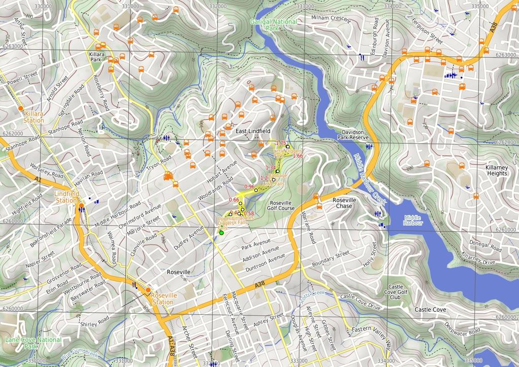
3 Are you ready to have fun? Please ensure you and your group are well prepared and equipped for all possible hazards and delays. Check park closures, weather information and Fire Danger Rating before setting out. Optional side trips and alternate routes noted are not included in this walks overall grade, length or time estimate. Please allow extra time for resting and exploring areas of interest. The authors, staff and owners of wildwalks take care in preparing this information but will not accept responsibility for any inconvenience, loss or injury you may experience. Please take care, have fun - Happy Walking. Getting there You can get to Int of Amarna Pde and Roseville Ave (gps: , 5.866) by car or bus. Car: There is free parking available. You can get back from Carlyle Rd (gps: , 5.927) by car or bus. Car: There is free parking available. Find up to date and more information inlcuding; travel directions, weather, park closures and walker feedback at Int of Amarna Pde and Roseville Ave (29 m 5 mins) From the signposted trackhead at the intersection of Amarna Pde and Roseville Ave, the walk passes the 'Little Digger Track' sign and heads down the steps. The walk then follows the bush track downstream along the creek, keeping the creek to the left. After a little while the track fades for about meters then arrives at the top of a waterfall. The track loops around the rocks, and down to a Y intersection just near the bottom of the same waterfall..29 Upper Little Diggers Falls This unnamed waterfall on Moores creek cascades about 3 meters from a wide sandstone platform into a wide (but shallow) pool below. The falls are surrounded by some lovely Eucalyptus trees with stunning red bark..29 Upper Little Diggers Falls ( m ) Turn right: From the intersection, this walk follows the bush track, keeping the creek on the left. The track heads down stream and soon comes to a rock platform next to a cascade (still on Moores creek)..39 Upper Moores Creek Falls This unnamed cascade on Moores creek has a fairly large rock platform on the southern bank of the creek. The area is not fenced, but there is a nice view looking at the moss covered rocks and small rock pools..39 Moores Creek Falls (4 m ) Continue straight: From the rock platform, the walk heads down stream a little, keeping the creek on the left, past a large Fern tree where the track turns right and heads up the hill, away from the creek. The walk then climbs a set of steps to come out opposite 27 Amarna Pde, Roseville..43 Int of Moores Creek Falls track and Amarna Pde (4 m ) Turn left: From the intersection the walk follows Amarna Pde towards the golf course, to the end of the road..47 End of Amarna Pde (9 m ) Turn left : From the end of Amarna Pde, this walk follows the Little Digger arrow down the stairs, keeping the golf course fence on the right. At the bottom of the stairs, the walk crosses the creek and then veers to the left, following the bush track upstream, along the creek, through the lush vegetation for short distance. The track then turns right, heads up the hill and then up the stairs, arriving near the end of Luxor Pde..56 Int of Luxor Pde and Amarna Pde track (2 m ) Turn right: From the intersection this, walk follows Luxor Pde a short distance to the end of the road and the 'Little Digger Track' sign pointing to 'Carnarvon Rd 4m'..58 End of Luxor Pde (8 m ) Turn left: From the end of Luxor Pde, this walk follows the 'Little Digger Track' sign pointing up the hill to 'Carnarvon Rd 4m'. The walk heads up the stairs and then flattens out, between the houses, and soon arrives at the bend in Golfers Lane..66 Bend in Golfers Lane (3 m 6 mins) Continue straight: From the intersection, this walk follows Golfers lane, keeping the timber fences on the right, and soon turns right onto Carnarvon Rd. The walk then heads down the hill to the intersection with Mycumbene Ave. Continue straight: From the intersection, this walk follows Carnarvon Road past the "No through road" sign (parallel to the small laneway) to the cul-desac at the end..96 End of Carnarvon Road (25 m 6 mins) Continue straight: From the end of Carnarvon Road, the walk follows the Little Digger Track sign, stepping up onto the short rock platform and following the bush track up the hill. After passing around the houses, the walk steadily winds down through the gully to the signposted intersection with the Little Falls Track..2 Optional sidetrip to Little Falls (3 m ) Veer right: From the intersection, the walk follows the "Little Falls 2min return" arrow along the bush track, heading down the hill and through the ferns to a small flat clearing next to a creek, just down stream from a small waterfall. At the end of this side trip, retrace your steps back to the main walk then Turn right..2 Little Falls Little falls are found along the Little Digger Track in East Lindfield. The small cascade is on Moores Creek, and is a single drop over a sandstone shelf. There is a small clearing on the western bank of the creek making a quiet area to sit and rest whilst trying to spot lyrebirds..2 Int of Little Digger and Little Falls Tracks (3 m 3 mins) Continue straight: From the intersection, leaving the signposted 'Little Falls Track' on the right, the walk follows the bush track. The walk winds through the gully and down some wooden steps, continuing along for a little while before coming to the signposted intersection with the 'Babbage Falls Track'..34 Optional sidetrip to Babbage Falls ( m ) Veer right: From the intersection, the walk follows the 'Babbage Falls' sign down the short hill, to the rock platform looking down on the Babbage Falls. At the end of this side trip, retrace your steps back to the main walk then Turn sharp right..34 Babbage Falls Babbage Falls are on Moores Creek in East Lindfield, just off the side of the Little Diggers Track. The falls flow off a large rock platform to a small pool in the creek below. Babbage Falls are named in honour of Eden Herschel Babbage. Babbage ( ) was known as 'The Father of Roseville' and was committed to developing a series of tracks through the area which was then known as Roseville park. More info..34 Int of Little Digger and Babbage Falls Tracks (32 m 8 mins) Continue straight: From the intersection (with the signposted 'Babbage Falls Track' on the right), the walk follows the bush track, heading north through the gully, winding through the bush and down some rock steps, where it crosses under two large rock overhangs. The walk continues through the bush, crossing a small creek and undulating through the gully until it comes down to the Moores Creek Bridge. (The track does not cross this bridge but it does provide nice views of the creek.).66 Moores Creek bridge (9 m ) Continue straight: With the Bridge on the right, the walk follows the bush track, heading north through the bush, passing a Little Digger Track information sign and continuing along the now wider track for a short distance before turning left and coming up to the 'T' intersection with the Carlyle Road management trail..75 Little Diggers Park Little Diggers Park is a bushland reserve to the north of Roseville Golf Course. The reserve protects the native flora and fauna on the banks of Moores Creek. The park was named in honour of William Hughes who lived in the area and was Australia's 7th Prime Minister. Billy Hughes was also nicknamed 'little digger' during WW, a name he carried to his grave in death in 952. The park is now managed by Ku-ring-gai Council, and regeneration is undertaken by the Moores Creek Bushcare Group. More info..75 Carlyle Road track and Little Digger Track Int. (4 m ) Turn left: From the intersection, this walk heads east, up the hill along the management trail, until coming to the end of Carlyle Rd, where there is a small playground.
4
5 Powered by TCPDF ( Summary navigation sheet for the Little Digger Track km From Up/Dwn Length Initial directions (Use full tracknotes and maps for more detail) Start Int of Amarna Pde and Roseville Ave ,5.866 (GR Parramatta River, 3269).29 Upper Little Diggers Falls ,5.877 (GR Parramatta River, 32262).39 Moores Creek Falls ,5.887 (GR Parramatta River, 32362).43 Int of Moores Creek Falls track and Amarna Pde ,5.89 (GR Parramatta River, 3236).47 End of Amarna Pde ,5.894 (GR Parramatta River, 3246).56 Int of Luxor Pde and Amarna Pde track ,5.89 (GR Parramatta River, 32362).58 End of Luxor Pde ,5.892 (GR Parramatta River, 32362).66 Bend in Golfers Lane ,5.889 (GR Parramatta River, 32363).96 End of Carnarvon Road ,5.98 (GR Parramatta River, 32564).2 Int of Little Digger and Little Falls Tracks ,5.928 (GR Parramatta River, 32765).2 Int of Little Digger and Little Falls Tracks ,5.928 (GR Parramatta River, 32765).34 Int of Little Digger and Babbage Falls Tracks ,5.934 (GR Parramatta River, 32767).34 Int of Little Digger and Babbage Falls Tracks ,5.934 (GR Parramatta River, 32767).66 Moores Creek bridge ,5.952 (GR Parramatta River, 32969).75 Carlyle Road track and Little Digger Track Int ,5.947 (GR Parramatta River, 32869) m 5 mins m 4 m 4 m 9 m From the signposted trackhead at the intersection of Amarna Pde and Roseville Ave, the walk passes the 'Little Digger Track' sign and heads down the steps. Turn right: From the intersection, this walk follows the bush track, keeping the creek on the left. Continue straight: From the rock platform, the walk heads down stream a little, keeping the creek on the left, past a large Fern tree where the track turns right and heads up the hill, away from the creek. Turn left: From the intersection the walk follows Amarna Pde towards the golf course, to the end of the road. Turn left : From the end of Amarna Pde, this walk follows the Little Digger arrow down the stairs, keeping the golf course fence on the right. 2 m Turn right: From the intersection this, walk follows Luxor Pde a short distance to the end of the road and the 'Little Digger Track' sign pointing to 'Carnarvon Rd 4m'. 8 m 3 m 6 mins 25 m 6 mins 3 m 3 m 3 mins Turn left: From the end of Luxor Pde, this walk follows the 'Little Digger Track' sign pointing up the hill to 'Carnarvon Rd 4m'. Continue straight: From the intersection, this walk follows Golfers lane, keeping the timber fences on the right, and soon turns right onto Carnarvon Rd. Continue straight: From the end of Carnarvon Road, the walk follows the Little Digger Track sign, stepping up onto the short rock platform and following the bush track up the hill. Optional sidetrip to Little Falls. Veer right: From the intersection, the walk follows the "Little Falls 2min return" arrow along the bush track, heading down the hill and through the ferns to a small flat clearing next to a creek, just down stream f... Continue straight: From the intersection, leaving the signposted 'Little Falls Track' on the right, the walk follows the bush track. m Optional sidetrip to Babbage Falls. Veer right: From the intersection, the walk follows the 'Babbage Falls' sign down the short hill, to the rock platform looking down on the Babbage Falls. 32 m 8 mins 9 m 4 m Continue straight: From the intersection (with the signposted 'Babbage Falls Track' on the right), the walk follows the bush track, heading north through the gully, winding through the bush and down some rock steps,... Continue straight: With the Bridge on the right, the walk follows the bush track, heading north through the bush, passing a Little Digger Track information sign and continuing along the now wider track for a short d... Turn left: From the intersection, this walk heads east, up the hill along the management trail, until coming to the end of Carlyle Rd, where there is a small playground.
Little Digger Track to Davidson Reserve and Lyrebird Circuit
 Little Digger Track to Davidson Reserve and Lyrebird Circuit 4 hrs 3 mins 11.5 km One way Hard track 4 47m Exploring both the eastern and western sides of Middle Harbour Creek, this walk follows the Little
Currie Rd to Davidson Park
 Currie Rd to Davidson Park 3 hrs 7.2 km One way Moderate track 28m Starting at Currie Rd in Forestville, this walk follows Middle Harbour to Davidson Park, under Roseville Bridge. There are two optional
Heathcote to Engadine via Audley
 Heathcote to Engadine via Audley 6 hrs 3 mins 5 km One way Hard track 4 635m Covering a large section of central Royal National Park, this walk goes through the heath and scrub along a well managed and
Rail to River Walk. 3 hrs. Hard track 7.5 km Circuit. 222m
 Rail to River Walk 3 hrs Hard track 7.5 km Circuit 4 222m This walk is a great one from Chatswood Station to the Lane Cove River National Park. The walk descends through the vegetated bushland which fills
Epping to Eastwood Station (via Lane Cove River)
") Epping to Eastwood Station (via Lane Cove River) hrs 45 mins 10.2 km One way Moderate track 189m Epping to Eastwood, via Lane Cove River, is the longer route through the bush between the stations. This
Epping to Eastwood Station (via Lane Cove River) hrs 45 mins 10.2 km One way Moderate track 189m Epping to Eastwood, via Lane Cove River, is the longer route through the bush between the stations. This
Waterfall to Heathcote
 Waterfall to Heathcote 5 hrs Hard track 10.8 km One way 4 467m This walk explores the heart of Heathcote National Park, and is easily accessed with a train station at either end. Although relatively close
Wentworth Falls Conservation Hut Loop
 Wentworth Falls Conservation Hut Loop 3 hrs Hard track 6.7 km Circuit 4 341m This scenic walk from Wentworth Falls Station, winds along the Nature Trail to Conservation Hut, then drops into the magnificent
Govetts Leap Loop. 1065m. 909m Blue Mountains National Park. 4 hrs 30 mins 8.7 km Circuit. Hard track 380m
 Govetts Leap Loop 4 hrs 30 mins 8.7 km Circuit Hard track 380m This walk, from Blackheath Train Station, is a fantastic way to see some of the iconic areas of the Blue Mountains in the Blackheath area.
Carrington Park to Leura Forest and pass loop
 Carrington Park to Leura Forest and pass loop 3 hrs Hard track 4.8 km Circuit 4 674m This walk is a fantastic way to see Leura Forest. The walk descends from Carrington Park, visiting Leura Forest and
Popes Glen, Pulpit Rock, Govetts Leap and Braeside Walk
 Popes Glen, Pulpit Rock, Govetts Leap and Braeside Walk 8 hrs Hard track 13.6 km Circuit 4 1068m This large circuit walk, from Popes Glen to Pulpit Rock, Govetts leap and along the Braeside Track, passes
Echo Point to Leura Forest via Three Sisters and Giant Stairs loop
 Echo Point to Leura Forest via Three Sisters and Giant Stairs loop 3 hrs 3.8 km Circuit Hard track 512m This walk starts from the popular Echo Point, in Katoomba, and winds down to the base of the Three
Hunters Hill to Epping Road
 Hunters Hill to Epping Road 2 hrs 30 mins 5.5 km One way Moderate track 154m An enjoyable walk through lower sections of the Lane Cove National Park, this walk features plenty of mangroves next to the
Epping to Pennant Hills Station (via Lane Cove River)
") Epping to Pennant Hills Station (via Lane Cove River) 3 hrs 5 mins 8.4 km One way Hard track 249m This walk, from Epping to Pennant Hills Station, is a great way to see the upper Lane Cove River Valley.
Epping to Pennant Hills Station (via Lane Cove River) 3 hrs 5 mins 8.4 km One way Hard track 249m This walk, from Epping to Pennant Hills Station, is a great way to see the upper Lane Cove River Valley.
Hornsby Blue Gum Walk
 Hornsby Blue Gum Walk 3 hrs Hard track 6.7 km Circuit 4 374m This delightful loop is one of the prettiest and most popular walks in the Hornsby area. Going from an environment of ferns and clear bushland
Wattamolla to Big Marley Beach
 Wattamolla to Big Marley Beach 4 hrs 10.4 km Circuit Moderate track 4m This walk is an excellent loop which takes in both the coast and the heathy inland of Royal National Park. Nearly the whole walk has
Katoomba Falls Circuit
 Katoomba Falls Circuit hr 5 mins.5 km Circuit Hard track 59m For those looking for a walk involving more than simple boardwalk, this trail winding through the temperate rain forest could be just the thing.
Rail to River and Stringybark Creek Reserve Walk
 Rail to River and Stringybark Creek Reserve Walk 4 hrs Hard track 11.2 km Circuit 4 302m This walk begins in the busy city of Chatswood and soon enters the nearby bushland around the Lane Cove River. The
Sid Pulsford Walk. 175m. 33m. 1 hr 45 mins 4.1 km One way. Hard track 118m. Gosford LGA
 Sid Pulsford Walk 1 hr 5 mins.1 km One way Hard track 118m Sid Pulsford Walk explores the ridge top of Kincumber Mountain, from Honeman's Rock to Green Point. The walk mostly follows wide management trails.
Middle Harbour Creek Loop
 Middle Harbour Creek Loop 5 hrs 45 mins 15.1 km Circuit Experienced only 5 570m This walk explores the upper reaches of Middle Harbour Creek, starting and ending at the great parklands at Davidson Park,
Dead Horse Gap Loop track
 Dead Horse Gap Loop track 4 hrs 30 mins Hard track 9.8 km Circuit 144m 4 This walk starts with a ride up the Kosciuszko Express Chairlift. There is an opportunity to eat at Australia's highest restaurant,
Morgans Creek to Padstow
 Morgans Creek to Padstow 2 hrs 45 mins 8 km One way Moderate track 3 144m This pleasant walk starts from the Morgans Creek park, at Henry Lawsons Drive, and follows the Georges River past the Boomerang
The Foreshore Walk. 24m. 1m Lake Macquarie LGA. 1 hr 15 mins 2.9 km One way. Hard track 81m
 The Foreshore Walk 1 hr 15 mins 2.9 km One way Hard track 81m This walk traverses the coastline of the Green Point reserve. By following a variety of tracks and occasionally traveling inland through eucalyptus
Mackerel Beach and Resolute Loop
 Mackerel Beach and Resolute Loop 3 hrs 5.4 km Circuit Hard track 384m This walk is another great walk in Ku-ring-gai Chase National Park, accessed by ferry. From the Mackerel Beach wharf, this walk uses
The Basin Track and Mackerel Track
 The Basin Track and Mackerel Track 3 hrs 5.9 km Circuit Hard track 226m This walk is a great way to see some popular areas in Ku-ring-gai Chase National Park. The walk from West Head Rd travels to The
Callicoma Loop. 174m. 98m. 2 hrs. Hard track 5.1 km Circuit. 153m
 Callicoma Loop 2 hrs Hard track 5.1 km Circuit 153m This great circuit walk passes through some really nice forest around the fringe of Cherrybrook. Highlights of the walk include some beautiful rock overhangs
Balmoral Beach to The Spit
 Balmoral Beach to The Spit 2 hrs 30 mins.3 km One way Hard track 85m This walks follows the coast from Balmoral to the Spit and across Spit Bridge. There are some alternate tracks to consider at high-tides,
Campbell Drive to Snapper Point
 Campbell Drive to Snapper Point 1 hr 45 mins 4.2 km One way Experienced only 135m This walk follows the Coast Track to Frazer Beach, along the Geebung and (overgrown) Grass Tree Tracks. From the northern
Mackerel Beach, West Head Loop
 Mackerel Beach, West Head Loop 5 hrs 8.6 km Circuit Hard track 422m The Mackerel Beach, West Head Loop is a walk which explores a large part of the West Head. The journey starts and finishes with a ferry
Sphinx, Warrimoo and Bobbin Head tracks
 Sphinx, Warrimoo and Bobbin Head tracks 4 hrs 9.6 km Circuit Moderate track 499m This great walk starts at the Sphinx Memorial and loops around via Cowan Creek, exploring diverse environments as it changes
Scenic World to Echo Point
 Scenic World to Echo Point 1 hr 15 mins 2.1 km One way Moderate track 192m This is one of the most popular tourist walks in the Katoomba area. The walk follows the cliffs along a well maintained and signposted
Wallarah Coastal Walk
 Wallarah Coastal Walk 3 hrs 8.3 km Return Hard track 247m This walk starts at Caves Beach and travels south along the coastline, until reaching the Pinney s Headland Lookout. There are many opportunities
Teralba to Charlestown Park track head
 Teralba to Charlestown Park track head 4 hrs 30 mins 13.3 km One way Moderate track 3 220m This section of the Great North Walk starts from the Teralba train station and winds down and around the edge
National Pass from Wentworth Falls to Conservation Hut
 National Pass from Wentworth Falls to Conservation Hut 3 hrs Hard track 3.6 km One way 739m Starting at Wentworth Falls picnic area, this scenic and historic walk explores many waterfalls, lookouts and
Upper Rumbalara circuit
 Upper Rumbalara circuit 1 hr 30 mins 3.3 km Circuit Hard track 176m A great circuit walk, covering most of the walking tracks and sights in the upper section of the Rumbalara Reserve. There is some really
Woolwich Wharf to Boronia Park
 Woolwich Wharf to Boronia Park 2 hrs 5.8 km One way Moderate track 175m Going through the streets of Hunters Hill, this walk is on the first segment of the Great North Walk. The majority of the walk is
Wentworth Falls Station Loop (Undercliff Walk)
") Wentworth Falls Station Loop (Undercliff Walk) 4 hrs 3 mins Hard track 8.9 km Circuit 658m 4 This walk passes some stunning waterfalls and views into the Jamison Valley, following the cliff edges around
Wentworth Falls Station Loop (Undercliff Walk) 4 hrs 3 mins Hard track 8.9 km Circuit 658m 4 This walk passes some stunning waterfalls and views into the Jamison Valley, following the cliff edges around
Under and Over Cliff Walk
 Under and Over Cliff Walk 4 hrs 9.4 km Circuit Moderate track 576m This walk from Wentworth Falls Station is a fantastic way to see a large majority of the Wentworth Falls cliffline. The track winds under
De Burghs Bridge to Fullers Bridge
 De Burghs Bridge to Fullers Bridge 2 hrs 3 mins Hard track 6 km One way 2m 4 Following the Lane Cove River, this walk mostly follows a section of the Great North Walk and is well maintained and signposted.
De Burgs Bridge to Thornleigh station
 De Burgs Bridge to Thornleigh station 3 hrs 45 mins 9.7 km One way Hard track 4 363m This walk follows a section of the Great North Walk, starting from De Burghs bridge. The walk winds north west, through
Bouddi Coastal Walk. 5 hrs. Hard track 8.1 km One way. 364m
 Bouddi Coastal Walk 5 hrs Hard track 8.1 km One way 4 364m This is one of the longer walks in the Bouddi National Park and it is rich in scenery. The walk follows the coastline with many side trips to
Blackheath Station to Junction Rock Loop (via Grand Canyon and Popes
 Blackheath Station to Junction Rock Loop (via Grand Canyon and Popes 8 hrs 30 mins 18.2 km Circuit Hard track 4 1254m This circuit starts in Blackheath and heads down into the Grand Canyon and Rodriguez
Berowra to Mt Kuring-gai
 Berowra to Mt Kuring-gai 4 hrs 30 mins 9.4 km One way Hard track 4 551m From the ridges above Cowan Creek, this walk takes in some great lookouts (especially around Mt Kuringgai) as well as enjoying an
Taronga Wharf to Chowder Bay
 Taronga Wharf to Chowder Bay 2 hrs 4.4 km One way Moderate track 246m Starting at Taronga Wharf, this walk passes many icons of Sydney, including Taronga Zoo, HMAS Sydney Mast, Chowder Bay. The walk also
Dubbo Gully and Ten Mile Hollow Circuit (via Clares Bridge)
") Dubbo Gully and Ten Mile Hollow Circuit (via Clares Bridge) 2 Days Hard track 24.3 km Circuit 4 1117m This two day (or ten hour) walk follows several historic roads, now closed to traffic. Starting with
Dubbo Gully and Ten Mile Hollow Circuit (via Clares Bridge) 2 Days Hard track 24.3 km Circuit 4 1117m This two day (or ten hour) walk follows several historic roads, now closed to traffic. Starting with
Spit Bridge to Middle Head Forts
 Spit Bridge to Middle Head Forts 2 hrs 30 mins 6.3 km One way Hard track 4 181m This scenic walk takes you from the Spit Bridge, along the coast to explore the Middle Head Forts. There are a few alternate
Federal Pass Walking Track
 Federal Pass Walking Track 5 hrs Hard track 8 km One way 4 989m This classic trail follows along the base of the cliffs from Leura to the Golden Stairs, passing many of the more popular sights of the Katoomba
Epping to Gordon Station
 Epping to Gordon Station 4 hrs 15 mins 11.7 km One way Hard track 4 365m This walk, from Epping Station to Gordon Station, passes below the homes which sit on the hills high above the Lane Cove River.
Patonga to Woy Woy. 5 hrs 45 mins 15.5 km One way. Hard track. 497m
 Patonga to Woy Woy 5 hrs 45 mins 15.5 km One way Hard track 4 497m This walk explores a variety of environments from the shore line and coastal cliffs near Patonga, to the dry, rocky and open ridge line.
Faulconbridge to Blaxland
 Faulconbridge to Blaxland 2 Days Experienced only 15.2 km One way 5 693m This two-day walk, or very solid one-day walk, takes you from station to station, through lush, scenic forest in the lower Blue
Green Point Circuit Walk
 Green Point Circuit Walk 3 hrs 7.7 km Circuit Hard track 269m This walk visits all of the popular locations in Green Point Reserve, as well as some of the lesser-visited areas inland. Taking in Sea Eagle
Wentworth Falls Station Loop
 Wentworth Falls Station Loop 5 hrs 3 mins 9.5 km Circuit Hard track 4 13m The Wentworth Falls Station Loop takes in most of the upper tracks around Wentworth Falls. There are many scenic views near the
Echo Point to Leura Forest Circuit
 Echo Point to Leura Forest Circuit 3 hrs 4.8 km Circuit Hard track 588m Forming a circuit around the cliffs and then the valley floor, this is a walk more then capable of convincing a walker of the beauty
Gordon to Chatswood Station
 Gordon to Chatswood Station 4 hrs 30 mins 12.2 km One way Hard track 4 381m This walk is a great way to get into the bush without being far from civilisation. The walk wanders through untouched valleys
Roseville to Macquarie Park
 Roseville to Macquarie Park 3 hrs 3 mins 8.8 km One way Hard track 4 29m This walk starts at Roseville station and explores the streets and alleyways of Roseville before joining the main spine of the Great
Wentworth Falls Loop. 893m. 665m. 6 hrs 10.2 km Circuit. Hard track 1093m. Blue Mountains National Park
 Wentworth Falls Loop 6 hrs 1.2 km Circuit Hard track 193m This is a great walk, both in size and spectacular views. The walk makes its way from Wentworth Falls train station and drops off the plateau,
Lane Cove Tourist Park River Circuit
 Lane Cove Tourist Park River Circuit 5 hrs 12 km Circuit Hard track 383m This walk follows a large section of Lane Cove River. The walk follows the Riverside Walking track up the Lane Cove River to De
Thornleigh to Hornsby
 Thornleigh to Hornsby 4 hrs Hard track 10.2 km One way 4 526m Starting at Thornleigh station you walk through suburban streets for a short while before diving into the bush at the southern end of Berowra
Hermitage Foreshore Track
 Hermitage Foreshore Track 1 Hr 2.2 km One way Moderate track 123m The Hermitage Foreshore Walk is a wonderful way to explore Sydney Harbour from the perspective of South Head. This walk starts from Nielsen
Glenbrook and Euroka Circuit
 Glenbrook and Euroka Circuit 2 Days 16.6 km Circuit Experienced only 790m This two day circuit, returning to Glenbrook Station, is a scenic walk which passes many of the tourist attractions within the
Bobbin Head Loop. 166m. 0m Ku-ring-gai Chase National Park. 5 hrs 12.9 km Circuit. Hard track 619m
 Bobbin Head Loop 5 hrs 12.9 km Circuit Hard track 619m This great circuit walk enjoys a variety of landscapes in Ku-ring-gai Chase National Park. The walk starts at the historic Sphinx war memorial and
Rumbalara Explorer. 158m. 5m Rumbalara Reserve. 2 hrs 45 mins 6.1 km Circuit. Hard track 326m
 Rumbalara Explorer 2 hrs 5 mins 6.1 km Circuit Hard track 326m Pretty well the grand tour of the Rumbalara Reserve, this walk takes in much of the great scenery the reserve has to offer. The walk covers
Sphinx to Mt Kuring-gai
 Sphinx to Mt Kuring-gai 4 hrs 45 mins 1.7 km One way Hard track 673m This walk starts at the Sphinx War Memorial and follows some well maintained and popular walking tracks down to Cowan Creek. Enjoy the
North Ryde Fairyland circuit
 North Ryde Fairyland circuit 2 hrs 30 mins Hard track 6.9 km Circuit 193m 4 Starting at North Ryde train station this walk explores a stretch of the Lane Cove River, visiting the historic Fairlylands Pleasure
Gosford to Lisarow. 202m
 Gosford to Lisarow 4 hrs 3 mins Hard track 11.3 km One way 4 479m This walk is a great way to explore the ridge-top bushland between Gosford and Lisarow. Passing through Rumbalara and Katandra Reserves,
Chatswood to Epping Station
 Chatswood to Epping Station 6 hrs Hard track 16.3 km One way 4 533m This walk, from Chatswood to Epping, is a long but enjoyable walk along the Lane Cove valley. The walk mostly follows the Lane Cove River
Spit Bridge to Manly (Manly Scenic Walkway)
") Spit Bridge to Manly (Manly Scenic Walkway) 3 hrs 45 mins 9.1 km One way Moderate track 349m The Spit to Manly walk is a classic bushwalk on Sydney's Northern Beaches. The walk follows a well-maintained
Spit Bridge to Manly (Manly Scenic Walkway) 3 hrs 45 mins 9.1 km One way Moderate track 349m The Spit to Manly walk is a classic bushwalk on Sydney's Northern Beaches. The walk follows a well-maintained
The Coast Track. 2 Days. Hard track 27.4 km One way. 1351m
 The Coast Track 2 Days Hard track 27.4 km One way 4 1351m Heading south, this walk covers the coastline of the Royal National Park and can truly only be described as amazing. With breathtaking coastal
Charlestown Park trackhead to Newcastle station
 Charlestown Park trackhead to Newcastle station 5 hrs 30 mins 12.1 km One way Hard track 4 287m This section of the Great North Walk starts from the Charleston Park track head and winds through the streets
Scenic world to Three Sisters Loop via Furber Steps
 Scenic world to Three Sisters Loop via Furber Steps 5 hrs 5.8 km Circuit Hard track 722m This walk starts from the popular Scenic World, in Katoomba, and winds down the Furber steps into the Jamison Valley,
Bouddi Ridge and Coastal Walk
 Bouddi Ridge and Coastal Walk 2 Days Hard track 27 km Circuit 4 126m This overnight walk takes in the majority of the magnificent Bouddi National Park. The walk starts from the pleasant Putty Beach camping
Manly to Seaforth Oval
 Manly to Seaforth Oval 5 hrs 45 mins 13.7 km One way Moderate track 3 624m This walk follows the Manly to Spit Scenic Walkway, then continues past The Spit Bridge to Seaforth Oval. The walk provides magnificent
Cape Banks Circuit. 50m. 2m Botany Bay National Park. 3 hrs 7.3 km Circuit. Hard track 190m
 Cape Banks Circuit 3 hrs 7.3 km Circuit Hard track 19m This Cape Banks Circuit has a lot to offer and is thoroughly recommended. The walking travels over beaches, through coastal forest and across exposed
Taronga Zoo to Spit Bridge
 Taronga Zoo to Spit Bridge 5 hrs Hard track 1.4 km One way 4 41m This is a scenic and culturally rich walk with views over Sydney Harbour and many interesting heritage buildings along the way. The start
Light to Light Walk 2 days
 Light to Light Walk 2 days 2 Days Hard track 3.9 km One way 4 794m Over two days, this classic walk explores the coast from Boyd Tower to the Green Cape Lighthouse in the south. Hegartys Bay Camp is over
Narrabeen Lagoon Trail (from Middle Creek)
") Narrabeen Lagoon Trail (from Middle Creek) 2 hrs 30 mins 8.6 km Circuit Very easy 1 105m The Narrabeen Lagoon Trail is a wonderful and accessible walk on the Northern Beaches of Sydney. The trail is used
Narrabeen Lagoon Trail (from Middle Creek) 2 hrs 30 mins 8.6 km Circuit Very easy 1 105m The Narrabeen Lagoon Trail is a wonderful and accessible walk on the Northern Beaches of Sydney. The trail is used
Six Foot Track. 1212m
 Six Foot Track 3 Days 44.8 km One way Hard track 4 2066m This classic walk takes you from Katoomba to Jenolan Caves via a historic horse route. The walk travels mainly along well-maintained service tracks
Sydney to Thornleigh via Lane Cove Tourist Park
 Sydney to Thornleigh via Lane Cove Tourist Park 2 Days 33 km One way Hard track 4 1114m This overnight walk starts from the Obelisk in Macquarie Park, Sydney, at the official start of the Great North Walk.
Harbour Bridge to Taronga Zoo
 Harbour Bridge to Taronga Zoo 4 hrs 9.8 km One way Moderate track 389m On this walk, you will explore much of the foreshore linking Milsons Point Station to Taronga Zoo Ferry wharf. The walk is mostly
VERN S CAMP from Minginui
 VERN S CAMP from Minginui Map: Kuratau, 1:50,000 V18 Refer Figures 1, 3, 4 and 5 GPS: Geodetic Datum 1949 Refer Figure 10a (Geographic) and 10b (NZ Grid) How to get to START: From the police station on
Detailed maps, and portaging and camping information follow.
 Overview of Bain route. The launch site is at Davidson Lake, just before the Manitoba/Ontario border. You can do a loop if you leave a vehicle at Tulabi Lake (at the canoe route parking lot). The road
Detailed Descriptions and Maps of Woodside s Nature Trails
 Detailed Descriptions and Maps of Woodside s Nature Trails Access Mill Road Trail Park along Anderson Mill road. Signs on West Pleasant Colony and Anderson Mill road clearly point to the beginning of the
MAPS & WALK NOTES. DAY 2: Greenwich Wharf to Woolwich Wharf
 MAPS & WALK NOTES DAY 2: Greenwich Wharf to Woolwich Wharf Total Distance: 15.5km Time: Approximately 5 hours 30 mins five Sections Walk Notes in Section Name Length Time 2:1 Greenwich Wharf to Northwood
Tideswell to Castleton
 Tideswell to Castleton 1 Walk summary Length: 14 km, 8.5 miles Maps: OS Explorer OL1 The Peak District - Dark Peak Area, OS Explorer OL24 The Peak District - White Peak Area, OS Landranger 110 Sheffield
Directions for Day 1: Colwood To Metchosin
 Colwood-Metchosin Page 1 of 8 Directions for Day 1: Colwood To Metchosin Start: Royal Roads University, Birds of a Feather B&B, or at Esquimalt Lagoon Finish: Your accommodation in Metchosin Time: 4-5
10 Miles Circular 5 hours
 VISIT RYEDALE PICKERING AND CAWTHORN CAMPS 10 Miles Circular 5 hours Moderate Terrain 120616 A 10 mile (16km) there and back walk from the market town of Pickering in Ryedale. The route heads north through
THE WELLDIGGERS ARMS, HESWORTH AND FITTLEWORTH TRAIL
 THE WELLDIGGERS ARMS, HESWORTH AND FITTLEWORTH TRAIL 5.5 miles Circular 3 hours 041017 Challenging Terrain A 300-year-old pub turned country-inn on the edge of the South Downs National Park, The Welldiggers
Harlington - Sharpenhoe - Pulloxhill
 Harlington - Sharpenhoe - Pulloxhill ID: 3676, Distance: 8 miles, Height gain: 140 Metres, Map: Explorer 193 Luton & Stevenage, Contributor: Dennis Jeanes Duration: 3 Hours 27 Mins Features Church,Great
RILLINGTON TO MALTON by Tania Dickinson
 RILLINGTON TO MALTON by Tania Dickinson This walk takes you from the Vale of Pickering up on to the Wold scarp, before dropping down again through the pretty village of Settrington and joining the Centenary
ULTRA-TRAIL AUSTRALIA May 2018 COURSE DESCRIPTION AND COURSE NOTES
 ULTRA-TRAIL AUSTRALIA 100 19-20 May 2018 COURSE DESCRIPTION AND COURSE NOTES LEG 1 Scenic World (Start) to Narrow Neck (Checkpoint 1) Course Description: From the start, at the front entrance of Scenic
Cross Country Skiing in the Tumbler Ridge Area
 Cross Country Skiing in the Tumbler Ridge Area There are numerous locations that are great for cross country skiing in the area surrounding Tumbler Ridge. Some are on trails that have hiking brochures
Calaveras Big Trees State Park--South Grove Loop
 Copyright 1999 by Jeff Robinson. You are free to use and reproduce this description for personal, not-for-profit, and not-forbusiness use. Any reproduction other than for personal use, including businesses,
9.5 km Circular 3 hours
 MEDIEVAL WAVERLEY Challenging Terrain A 6 mile (9.5km) undulating circular walk from Tilford village passing close to The Sands village and the historic ruins of Waverley Abbey. From the top of Crooksbury
Risk rating. Hazard Risk Likelihood Consequ ences. Who is responsib le for risk control Leader. Examples of Risk Controls
 Hazard Risk Likelihood Consequ ences Bush fire Injury or Moderate (Midsummer - walk in bush or forest for example) cold Frostbite Hypothermia Death in winter or wet conditions Likely in alpine areas and
Winterfold Wood. point your feet on a new path. In Brief
 point your feet on a new path Winterfold Wood Distance: 8½ km=5¼ miles Region: Surrey Author: Schwebefuss Refreshments: Windmill Inn, Peaslake after the walk moderate walking with many gradients Date written:
Review of Guidelines for Cycleway Safety Fencing
 Review of Guidelines for Cycleway 1.0 PURPOSE 1.1 This document is meant to provide a review of available reference documents for determining appropriate fencing requirements for cycleway paths and shared
LOCAL CIRCUIT EM1: EAST MALLING & BARMING HEATH. N 2m ROADS: Significant roads PATHS: Starting direction Barming Longsole Mission Church
 Ditton Church Scott Close LOCAL CIRCUIT EM1: EAST MALLING & BARMING HEATH 6 Community Centre F Open fields (see 'Introductory Notes') 1m 88 Direction label (as in the walk notes) East Malling Church -
Trail and Driving Directions
 Trail and Driving Directions GETTING TO THE START: FROM CADILLAC: Follow M-55 west from US131 for 20.9 miles to the corner of M-37 and M-55 FROM THE INTERSECTION OF M-55 AND M-37: Head west on M-55 2.7
Times. S E S/Rd(E) Wakefield Road) Wakefield Rural Fire Brigade
 Wakefield Road) Wakefield Rural Fire Brigade") START On York Street, Teralba adjacent to Tulkaba Park Sports Pavilion (on leaving travel west on York Street) [EEP-1A] Position* Altitude Distance (km)* Trail S32 57.593 E151 36.520 21 0.5 0.5 S/Rd(E)
START On York Street, Teralba adjacent to Tulkaba Park Sports Pavilion (on leaving travel west on York Street) [EEP-1A] Position* Altitude Distance (km)* Trail S32 57.593 E151 36.520 21 0.5 0.5 S/Rd(E)
Using smartphones for cycle planning Authors: Norman, G. and Kesha, N January 2015
 Using smartphones for cycle planning Authors: Norman, G. and Kesha, N January 2015 Abstract There has been an inherent lack of information available to transport and urban planners when looking at cycle
The Hundred Parishes
 The Hundred Parishes Walks from railway stations number 9 6.4 miles (10kms) from Bishop s Stortford to Stansted Mountfitchet Start: Bishop s Stortford station (Grid Reference TL492209) (ample parking and