BOI / DRH S. 13 th Street Mixed use office/retail development with residential dormitory
|
|
|
- Philippa Ray
- 5 years ago
- Views:
Transcription

1 Jim D. Hansen, President Sara M. Baker, Vice President Rebecca W. Arnold, Commissioner Kent Goldthorpe, Commissioner Paul Woods, Commissioner October 21, 2015 To: Rick Nesser ISS River Partners, LLC 8312 W. Northview, Ste 120 Bosie, ID Subject: BOI / DRH S. 13 th Street Mixed use office/retail development with residential dormitory On April 24, 2015, the Ada County Highway District approved CUP for a 6 story office building and a self-storage facility. The site specific conditions of approval also apply to DRH If you have any questions, please feel free to contact me at (208) Sincerely, Dawn Battles Planner I Development Services cc: City of Boise by Glancey Rockwell & Associates Ada County Highway District 3775 Adams Street Garden City, ID PH FX
2 Standard Conditions of Approval 1. All proposed irrigation facilities shall be located outside of the ACHD right-of-way (including all easements). Any existing irrigation facilities shall be relocated outside of the ACHD right-of-way (including all easements).private Utilities including sewer or water systems are prohibited from being located within the ACHD right-of-way. 2. In accordance with District policy, , the applicant may be required to update any existing non-compliant pedestrian improvements abutting the site to meet current Americans with Disabilities Act (ADA) requirements. The applicant s engineer should provide documentation of ADA compliance to District Development Review staff for review. 3. Replace any existing damaged curb, gutter and sidewalk and any that may be damaged during the construction of the proposed development. Contact Construction Services at (with file number) for details. 4. A license agreement and compliance with the District s Tree Planter policy is required for all landscaping proposed within ACHD right-of-way or easement areas. 5. All utility relocation costs associated with improving street frontages abutting the site shall be borne by the developer. 6. It is the responsibility of the applicant to verify all existing utilities within the right-of-way. The applicant at no cost to ACHD shall repair existing utilities damaged by the applicant. The applicant shall be required to call DIGLINE ( ) at least two full business days prior to breaking ground within ACHD right-of-way. The applicant shall contact ACHD Traffic Operations in the event any ACHD conduits (spare or filled) are compromised during any phase of construction. 7. Utility street cuts in pavement less than five years old are not allowed unless approved in writing by the District. Contact the District s Utility Coordinator at (with file numbers) for details. 8. All design and construction shall be in accordance with the ACHD Policy Manual, ISPWC Standards and approved supplements, Construction Services procedures and all applicable ACHD Standards unless specifically waived herein. An engineer registered in the State of Idaho shall prepare and certify all improvement plans. 9. Construction, use and property development shall be in conformance with all applicable requirements of ACHD prior to District approval for occupancy. 10. No change in the terms and conditions of this approval shall be valid unless they are in writing and signed by the applicant or the applicant s authorized representative and an authorized representative of ACHD. The burden shall be upon the applicant to obtain written confirmation of any change from ACHD. 11. If the site plan or use should change in the future, ACHD Planning Review will review the site plan and may require additional improvements to the transportation system at that time. Any change in the planned use of the property which is the subject of this application, shall require the applicant to comply with ACHD Policy and Standard Conditions of Approval in place at that time unless a waiver/variance of the requirements or other legal relief is granted by the ACHD Commission.
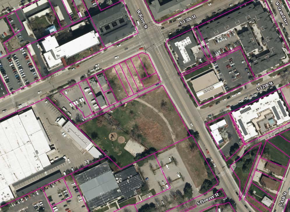
3 Development Services Department Project/File: Lead Agency: Site address: BOI /CUP This is a conditional use permit application for a special exception to allow for the development of a 6 story office building at the corner of 13 th and River Streets, and a 45,286 square foot urban self-storage facility on approximately acres. The site is located at 1201 W. River Street, or at the southwest corner of 13 th and River Streets in Boise, Idaho. City of Boise 1201 W. River Street Staff Approval: April 24, 2015 Applicant: Rick Nesser ISS River Partners, LLC 8312 W. Northview, STE 120 Boise, ID Representative: Tamara Thompson The Land Group 462 E. Shore Drive, STE 100 Eagle, ID Staff Contact: Mindy Wallace Phone: mwallace@achdidaho.org A. Findings of Fact 1. Description of Application: The applicant is requesting approval of a conditional use permit application for a special exception to allow for the development of a 6 story office building at the corner of 13 th and River Streets, and a 45,286 square foot urban self-storage facility on approximately acres. The site is located at 1201 W. River Street, or at the southwest corner of 13 th and River Streets in Boise, Idaho. 2. Description of Adjacent Surrounding Area: Direction Land Use Zoning North Residential office R-ODD South Residential office R-ODD East Residential office R-ODD West Residential office R-ODD 3. Site History: ACHD has not previously reviewed this site for a development application. 1 BOI /CUP
4 4. Transit: Transit services are available to serve this site via routes 4, 5, and New Center Lane Miles: This development will not add any new center lane miles of roadway to the public street inventory. 6. Impact Fees: There will be an impact fee that is assessed and due prior to issuance of any building permits. The assessed impact fee will be based on the impact fee ordinance that is in effect at that time. 7. Capital Improvements Plan/ Integrated Five Year Work Plan: There are currently no roadways, bridges or intersections in the general vicinity of the project that are currently in t the District s Capital Improvement Plan (CIP). The follow roadway segments are scheduled for overlays (roadway resurfacing) Integrated Five Year Work Plan (IFYWP) for This work is anticipated to start in the spring of 2015 and be completed by the fall. 13th Street from River Street to Front Street 13th Street from Shoreline Drive to River Street River Street from N. 12th Street to N. 9th Street River Street from Americana Boulevard to N. 12th Street B. Traffic Findings for Consideration 1. Trip Generation: This development is estimated to generate 285 vehicle trips per day; 35 vehicle trips per hour in the PM peak hour based on the Institute of Transportation Engineers Trip Generation Manual, 9 th edition. 2. Condition of Area Roadways Traffic Count is based on Vehicles per hour (VPH) Roadway Frontage Functional Classification River Street 360-feet Collector 842 Better than D 13 th Street 180-feet Collector 264 Better than D * Acceptable level of service for a two-lane collector is D (425 VPH). * Acceptable level of service for a three-lane collector is D (530 VPH). * Acceptable level of service for a five-lane collector is D (1,080 VPH). 3. Average Daily Traffic Count (VDT) Average daily traffic counts are based on ACHD s most current traffic counts. The average daily traffic count for River Street east of 13 th Street was 14,967 on 12/3/14. The average daily traffic count for 13 th Street south of River Street was 5,911 on 12/17/14. C. Findings for Consideration PM Peak Hour Traffic Count PM Peak Hour Level of Service Existing Plus Project Better than D Better than D 1. River Street a. Existing Conditions: River Street is improved with 5-travel lanes, vertical curb, gutter, and 7- foot wide attached sidewalks abutting the site. There is 83-feet of right-of-way for River Street (46-feet from centerline). 2 BOI /CUP
5 b. Policy: Collector Street Policy: District policy states that the developer is responsible for improving all collector frontages adjacent to the site or internal to the development as required below, regardless of whether access is taken to all of the adjacent streets. Master Street Map and Typologies Policy: District policy states that if the collector street is designated with a typology on the Master Street Map, that typology shall be considered for the required street improvements. If there is no typology listed in the Master Street Map, then standard street sections shall serve as the default. Sidewalk Policy: District policy requires a concrete sidewalks at least 5-feet wide to be constructed on both sides of all collector streets. A parkway strip at least 6-feet wide between the back-of-curb and street edge of the sidewalk is required to provide increased safety and protection of pedestrians. Consult the District s planter width policy if trees are to be placed within the parkway strip. Sidewalks constructed next to the back-of-curb shall be a minimum of 7-feet wide. Detached sidewalks are encouraged and should be parallel to the adjacent roadway. Meandering sidewalks are discouraged. A permanent right-of-way easement shall be provided if public sidewalks are placed outside of the dedicated right-of-way. The easement shall encompass the entire area between the rightof-way line and 2-feet behind the back edge of the sidewalk. Sidewalks shall either be located wholly within the public right-of-way or wholly within an easement. Minor Improvements Policy: District Policy states that minor improvements to existing streets adjacent to a proposed development may be required. These improvements are to correct deficiencies or replace deteriorated facilities. Included are sidewalk construction or replacement; curb and gutter construction or replacement; replacement of unused driveways with curb, gutter and sidewalk; installation or reconstruction of pedestrian ramps; pavement repairs; signs; traffic control devices; and other similar items. ACHD Master Street Map: ACHD Policy Section requires the Master Street Map (MSM) guide the right-of-way acquisition, collector street requirements, and specific roadway features required through development. This segment of River Street is designated in the MSM as a Town Center Collector with 3-lanes and on-street bike lanes, a 48-foot street section within 76-feet of right-of-way. c. Applicant Proposal: The applicant has proposed to remove the existing 7-foot wide attached concrete sidewalk and replace it with an 8-foot wide planter strip and 6-foot wide detached concrete sidewalk on River Street abutting the site. d. Staff Comments/Recommendations: River Street in its current configuration with 65-feet of pavement curb-to-curb contains all the elements of a Town Center Collector; as such staff does not recommend any improvements or right-of-way dedication as part of this application. The applicant s proposal to replace the existing attached sidewalks with detached sidewalks meets District policy and should be approved, as proposed. The applicant should be required to provide a permanent right-of-way easement if public sidewalks are placed outside of the dedicated right-of-way. Consistent with ACHD s Minor Improvement policy, the applicant should be required to replace any broken or deteriorated curb and gutter on River Street abutting the site th Street a. Existing Conditions: 13 th Street is improved with 3-travel lanes, a dedicated right turn lane at the River Street intersection, on street parking, vertical curb, gutter, and 7-foot wide attached 3 BOI /CUP
6 sidewalks abutting the site. There is 80-feet of right-of-way for 13 th Street (42-feet from centerline). b. Policy: Collector Street Policy: District policy states that the developer is responsible for improving all collector frontages adjacent to the site or internal to the development as required below, regardless of whether access is taken to all of the adjacent streets. Master Street Map and Typologies Policy: District policy states that if the collector street is designated with a typology on the Master Street Map, that typology shall be considered for the required street improvements. If there is no typology listed in the Master Street Map, then standard street sections shall serve as the default. Sidewalk Policy: District policy requires a concrete sidewalks at least 5-feet wide to be constructed on both sides of all collector streets. A parkway strip at least 6-feet wide between the back-of-curb and street edge of the sidewalk is required to provide increased safety and protection of pedestrians. Consult the District s planter width policy if trees are to be placed within the parkway strip. Sidewalks constructed next to the back-of-curb shall be a minimum of 7-feet wide. Detached sidewalks are encouraged and should be parallel to the adjacent roadway. Meandering sidewalks are discouraged. A permanent right-of-way easement shall be provided if public sidewalks are placed outside of the dedicated right-of-way. The easement shall encompass the entire area between the rightof-way line and 2-feet behind the back edge of the sidewalk. Sidewalks shall either be located wholly within the public right-of-way or wholly within an easement. Minor Improvements Policy: District Policy states that minor improvements to existing streets adjacent to a proposed development may be required. These improvements are to correct deficiencies or replace deteriorated facilities. Included are sidewalk construction or replacement; curb and gutter construction or replacement; replacement of unused driveways with curb, gutter and sidewalk; installation or reconstruction of pedestrian ramps; pavement repairs; signs; traffic control devices; and other similar items. ACHD Master Street Map: ACHD Policy Section requires the Master Street Map (MSM) guide the right-of-way acquisition, collector street requirements, and specific roadway features required through development. This segment of 13 th Street is designated in the MSM as a Town Center Collector with 3-lanes and on-street bike lanes, a 48-foot street section within 76-feet of right-of-way. c. Applicant Proposal: The applicant has proposed to remove the existing 7-foot wide attached concrete sidewalk and replace it with an 8-foot wide planter strip and 6-foot wide detached concrete sidewalk on River Street abutting the site. d. Staff Comments/Recommendations: 13 th Street in its current configuration with 52 to 60- feet of pavement curb-to-curb contains all the elements of a Town Center Collector; as such staff does not recommend any improvements or right-of-way dedication as part of this application. The applicant s proposal to replace the existing attached sidewalks with detached sidewalks meets District policy and should be approved, as proposed. The applicant should be required to provide a permanent right-of-way easement shall be provided if public sidewalks are placed outside of the dedicated right-of-way. Consistent with ACHD s Minor Improvement policy, the applicant should be required to replace any broken or deteriorated curb and gutter on 13 th Street abutting the site. 4 BOI /CUP
7 3. Alleys a. Existing Conditions: There is one 16-foot wide alley abutting the site. There is 16-feet of right-of-way for the alley. The alley is gated at the south end to provide a secure area for the US Postal Service facility located at the south of the site. b. Policy: Existing Alley Policy: District Policy states that if a proposed development abuts an existing alley, the dedication of additional right-of-way to obtain a minimum width from the centerline of the alley of 8-feet for residential uses and 10-feet for non-residential or commercial uses may be required. Each development will be reviewed by the District on a case-by-case basis. If the proposed development takes access from an alley, the developer will be required to pave the entire width of the right-of-way from the nearest public street to and abutting the development. Alley Parking & Setbacks Policy: District Policy states that parking within the alley right-of-way is prohibited. No Parking signs are required to be installed by the developer. The signs should be located at the alley/street intersections. Parking which is entered from the alley shall be designed so the minimum clear distance from the back of the parking stall to the opposite side of the alley is 20-feet for all perpendicular parking. Setbacks for structures taking access from the alley should be closely coordinated with the lead land use agency. The setbacks shall either discourage parking within the alley (where it may partially block or occur within the right-of-way) or allow adequate area for one perpendicular parking pad. In order to discourage parking, building setbacks shall be minimal from the alley right-of-way line, while still achieving the required 20-feet of back-up space from a garage or other parking structure to the opposite side of the alley (i.e. 4-foot setback foot alley= 20-feet for back-up space). c. Applicant Proposal: The applicant has proposed to widen the existing 16-foot wide alley approach onto River Street located approximately 190-feet east of 13 th Street to a width of 24- feet. The applicant is proposing to dedicate additional right-of-way to widen the alley to 20- feet in width from River Street south 163-feet tapering to 16-feet in width. On the west side of the alley, the applicant has proposed to construct 6 perpendicular parking stalls located 28-feet south of River Street. The parking area opens up to a 23-foot wide driveway. The applicant has proposed to construct an additional 26-foot wide driveway onto the alley located approximately 150-feet south of River Street. On the east side of the alley, the applicant has proposed to construct 2 parallel parking stalls located approximately 18-feet south of River Street. The applicant has proposed to construct one 24-foot wide gated enter only driveway onto the alley located approximately 80-feet south of River Street and 30-foot wide gated exit only driveway located approximately 150-feet south of River Street. The exit only driveway abuts an open area for a trash enclosure and 3 parking stalls. This open area is approximately 73-feet wide. 5 BOI /CUP

8 d. Staff Comments/Recommendations: The applicant s proposal to widen the alley approached onto River Street should be approved, as proposed. The alley approach should be reconstructed as a curb return type driveway. The applicant s proposal to dedicate additional alley right-of-way to total 20-feet from River Street south 163-feet should be approved, as proposed. The applicant s proposal for the driveways and parking configuration on the east and west sides of the alley should be approved, as proposed. 4. Driveways th Street a. Existing Conditions: There is a 20-foot wide driveway onto 13 th Street from the site. The driveway is located approximately 170-feet south of River Street (measured centerline to centerline). b. Policy: Access Policy: District Policy states that all access points associated with development applications shall be determined in accordance with the policies in this section and Section Access points shall be reviewed only for a development application that is being considered by the lead land use agency. Approved access points may be relocated and/or restricted in the future if the land use intensifies, changes, or the property redevelops. District Policy states that the primary function of a collector is to intercept traffic from the local street system and carry that traffic to the nearest arterial. A secondary function is to 6 BOI /CUP
9 service adjacent property. Access will be limited or controlled. Collectors may also be designated at bicycle and bus routes. Driveway Location Policy District policy requires driveways located on collector roadways near a signalized intersection to be located outside the area of influence; OR a minimum of 440-feet from the signalized intersection for a full-access driveway and a minimum of 220-feet from the signalized intersection for a right-in/right-out only driveway. Dimensions shall be measured from the centerline of the intersection to the centerline of the driveway Successive Driveways: District policy Table 1, requires driveways located on collector roadways with a speed limit of 20 MPH and daily traffic volumes greater than 200 VTD to align or offset a minimum of 245-feet from any existing or proposed driveway. Driveway Width Policy: District policy restricts high-volume driveways (100 VTD or more) to a maximum width of 36-feet and low-volume driveways (less than 100 VTD) to a maximum width of 30-feet. Curb return type driveways with 30-foot radii will be required for high-volume driveways with 100 VTD or more. Curb return type driveways with 15-foot radii will be required for low-volume driveways with less than 100 VTD. Driveway Paving Policy: Graveled driveways abutting public streets create maintenance problems due to gravel being tracked onto the roadway. In accordance with District policy, , the applicant should be required to pave the driveway its full width and at least 30- feet into the site beyond the edge of pavement of the roadway and install pavement tapers in accordance with Table 2 under District Policy Minor Improvements Policy: District Policy states that minor improvements to existing streets adjacent to a proposed development may be required. These improvements are to correct deficiencies or replace deteriorated facilities. Included are sidewalk construction or replacement; curb and gutter construction or replacement; replacement of unused driveways with curb, gutter and sidewalk; installation or reconstruction of pedestrian ramps; pavement repairs; signs; traffic control devices; and other similar items. c. Applicant s Proposal: The applicant is proposing to close the existing driveway onto 13 th Street and construct a new 22-foot wide full access driveway located approximately 200-feet south of River Street. d. Staff Comments/Recommendations: The applicant's proposal does not meet District Driveway Location or Successive Driveway policies; however, staff recommends a modification of policy to allow the driveway to be located as proposed. Staff s recommendation is due to the fact that the driveway onto 13 th Street has very low traffic volumes and dead ends at Shoreline south of the site, and the applicant has not proposed any driveways onto River Street, a high volume collector roadway. This staff level modification was reviewed and approved by the Deputy Director of Engineering, within the established authority levels. The driveway should be constructed as a curb return type driveway and paved its full width at least 30-feet into the site beyond the edge of pavement of 13 th Street. 5. Tree Planters Tree Planter Policy: Tree Planter Policy: The District s Tree Planter Policy prohibits all trees in planters less than 8-feet in width without the installation of root barriers. Class II trees may be allowed in planters with a minimum width of 8-feet, and Class I and Class III trees may be allowed in planters with a minimum width of 10-feet. 7 BOI /CUP
10 6. Landscaping Landscaping Policy: A license agreement is required for all landscaping proposed within ACHD right-of-way or easement areas. Trees shall be located no closer than 10-feet from all public storm drain facilities. Landscaping should be designed to eliminate site obstructions in the vision triangle at intersections. District Policy requires a 40-foot vision triangle and a 3-foot height restriction on all landscaping located at an uncontrolled intersection and a 50-foot offset from stop signs. Landscape plans are required with the submittal of civil plans and must meet all District requirements prior to signature of the final plat and/or approval of the civil plans. 7. Other Access 13 th Street and River Street are classified as collector roadways. Other than the access specifically approved with this application, direct lot access is prohibited to these roadways. D. Site Specific Conditions of Approval 1. Remove the existing 7-foot wide attached concrete sidewalk and replace it with an 8-foot wide planter strip and 6-foot wide detached concrete sidewalk on 13 th Street and River Street, as proposed. 2. Provide a permanent right-of-way easement if public sidewalks are placed outside of the dedicated right-of-way. 3. Replace any broken or deteriorated curb and gutter, and unused curb cuts on 13 th Street and River Street abutting the site. 4. Construct a 22-foot wide full access driveway onto 13 th Street located approximately 200-feet south of River Street, as proposed. Construct the driveway as a curb return type driveway and paved its full width at least 30-feet into the site beyond the edge of pavement of 13 th Street. 5. Widen the alley approach onto River Street to 24-feet, as proposed. Reconstruct as a curb return type driveway. 6. Modify the alley parking and driveways per the site plan on page 6 of this report. 7. Payment of impacts fees are due prior to issuance of a building permit. 8. Comply with all Standard Conditions of Approval. E. Standard Conditions of Approval 1. All proposed irrigation facilities shall be located outside of the ACHD right-of-way (including all easements). Any existing irrigation facilities shall be relocated outside of the ACHD rightof-way (including all easements). 2. Private Utilities including sewer or water systems are prohibited from being located within the ACHD right-of-way. 3. In accordance with District policy, , the applicant may be required to update any existing non-compliant pedestrian improvements abutting the site to meet current Americans with Disabilities Act (ADA) requirements. The applicant s engineer should provide documentation of ADA compliance to District Development Review staff for review. 4. Replace any existing damaged curb, gutter and sidewalk and any that may be damaged during the construction of the proposed development. Contact Construction Services at (with file number) for details. 5. A license agreement and compliance with the District s Tree Planter policy is required for all landscaping proposed within ACHD right-of-way or easement areas. 8 BOI /CUP
11 6. All utility relocation costs associated with improving street frontages abutting the site shall be borne by the developer. 7. It is the responsibility of the applicant to verify all existing utilities within the right-of-way. The applicant at no cost to ACHD shall repair existing utilities damaged by the applicant. The applicant shall be required to call DIGLINE ( ) at least two full business days prior to breaking ground within ACHD right-of-way. The applicant shall contact ACHD Traffic Operations in the event any ACHD conduits (spare or filled) are compromised during any phase of construction. 8. Utility street cuts in pavement less than five years old are not allowed unless approved in writing by the District. Contact the District s Utility Coordinator at (with file numbers) for details. 9. All design and construction shall be in accordance with the ACHD Policy Manual, ISPWC Standards and approved supplements, Construction Services procedures and all applicable ACHD Standards unless specifically waived herein. An engineer registered in the State of Idaho shall prepare and certify all improvement plans. 10. Construction, use and property development shall be in conformance with all applicable requirements of ACHD prior to District approval for occupancy. 11. No change in the terms and conditions of this approval shall be valid unless they are in writing and signed by the applicant or the applicant s authorized representative and an authorized representative of ACHD. The burden shall be upon the applicant to obtain written confirmation of any change from ACHD. 12. If the site plan or use should change in the future, ACHD Planning Review will review the site plan and may require additional improvements to the transportation system at that time. Any change in the planned use of the property which is the subject of this application, shall require the applicant to comply with ACHD Policy and Standard Conditions of Approval in place at that time unless a waiver/variance of the requirements or other legal relief is granted by the ACHD Commission. F. Conclusions of Law 1. The proposed site plan is approved, if all of the Site Specific and Standard Conditions of Approval are satisfied. 2. ACHD requirements are intended to assure that the proposed use/development will not place an undue burden on the existing vehicular transportation system within the vicinity impacted by the proposed development. G. Attachments 1. Vicinity Map 2. Site Plan 3. Utility Coordinating Council 4. Development Process Checklist 5. Request for Reconsideration Guidelines 9 BOI /CUP
12 VICINITY MAP 10 BOI /CUP
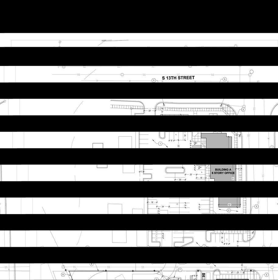
13 SITE PLAN 11 BOI /CUP
14 Ada County Utility Coordinating Council Developer/Local Improvement District Right of Way Improvements Guideline Request Purpose: To develop the necessary avenue for proper notification to utilities of local highway and road improvements, to help the utilities in budgeting and to clarify the already existing process. 1) Notification: Within five (5) working days upon notification of required right of way improvements by Highway entities, developers shall provide written notification to the affected utility owners and the Ada County Utility Coordinating Council (UCC). Notification shall include but not be limited to, project limits, scope of roadway improvements/project, anticipated construction dates, and any portions critical to the right of way improvements and coordination of utilities. 2) Plan Review: The developer shall provide the highway entities and all utility owners with preliminary project plans and schedule a plan review conference. Depending on the scale of utility improvements, a plan review conference may not be necessary, as determined by the utility owners. Conference notification shall also be sent to the UCC. During the review meeting the developer shall notify utilities of the status of right of way/easement acquisition necessary for their project. At the plan review conference each company shall have the right to appeal, adjust and/or negotiate with the developer on its own behalf. Each utility shall provide the developer with a letter of review indicating the costs and time required for relocation of its facilities. Said letter of review is to be provided within thirty calendar days after the date of the plan review conference. 3) Revisions: The developer is responsible to provide utilities with any revisions to preliminary plans. Utilities may request an updated plan review meeting if revisions are made in the preliminary plans which affect the utility relocation requirements. Utilities shall have thirty days after receiving the revisions to review and comment thereon. 4) Final Notification: The developer will provide highway entities, utility owners and the UCC with final notification of its intent to proceed with right of way improvements and include the anticipated date work will commence. This notification shall indicate that the work to be performed shall be pursuant to final approved plans by the highway entity. The developer shall schedule a preconstruction meeting prior to right of way improvements. Utility relocation activity shall be completed within the times established during the preconstruction meeting, unless otherwise agreed upon. Notification to the Ada County UCC can be sent to: 50 S. Cole Rd. Boise 83707, or Visit iducc.com for notification information. 12 BOI /CUP
15 Development Process Checklist Items Completed to Date: Submit a development application to a City or to Ada County The City or the County will transmit the development application to ACHD The ACHD Planning Review Section will receive the development application to review The Planning Review Section will do one of the following: Send a No Review letter to the applicant stating that there are no site specific conditions of approval at this time. Write a Staff Level report analyzing the impacts of the development on the transportation system and evaluating the proposal for its conformance to District Policy. Write a Commission Level report analyzing the impacts of the development on the transportation system and evaluating the proposal for its conformance to District Policy. Items to be completed by Applicant: For ALL development applications, including those receiving a No Review letter: The applicant should submit one set of engineered plans directly to ACHD for review by the Development Review Section for plan review and assessment of impact fees. (Note: if there are no site improvements required by ACHD, then architectural plans may be submitted for purposes of impact fee assessment.) The applicant is required to get a permit from Construction Services (ACHD) for ANY work in the right-ofway, including, but not limited to, driveway approaches, street improvements and utility cuts. Pay Impact Fees prior to issuance of building permit. Impact fees cannot be paid prior to plan review approval. DID YOU REMEMBER: Construction (Non-Subdivisions) Driveway or Property Approach(s) Submit a Driveway Approach Request form to ACHD Construction (for approval by Development Services & Traffic Services). There is a one week turnaround for this approval. Working in the ACHD Right-of-Way Four business days prior to starting work have a bonded contractor submit a Temporary Highway Use Permit Application to ACHD Construction Permits along with: a) Traffic Control Plan b) An Erosion & Sediment Control Narrative & Plat, done by a Certified Plan Designer, if trench is >50 or you are placing >600 sf of concrete or asphalt. Construction (Subdivisions) Sediment & Erosion Submittal At least one week prior to setting up a Pre-Construction Meeting an Erosion & Sediment Control Narrative & Plan, done by a Certified Plan Designer, must be turned into ACHD Construction to be reviewed and approved by the ACHD Stormwater Section. Idaho Power Company Vic Steelman at Idaho Power must have his IPCO approved set of subdivision utility plans prior to Pre-Con being scheduled. Final Approval from Development Services is required prior to scheduling a Pre-Con. 13 BOI /CUP
16 Request for Appeal of Staff Decision 1. Appeal of Staff Decision: The Commission shall hear and decide appeals by an applicant of the final decision made by the Development Services Manager when it is alleged that the Development Services Manager did not properly apply this section , did not consider all of the relevant facts presented, made an error of fact or law, abused discretion or acted arbitrarily and capriciously in the interpretation or enforcement of the ACHD Policy Manual. a. Filing Fee: The Commission may, from time to time, set reasonable fees to be charged the applicant for the processing of appeals, to cover administrative costs. b. Initiation: An appeal is initiated by the filing of a written notice of appeal with the Secretary of Highway Systems, which must be filed within ten (10) working days from the date of the decision that is the subject of the appeal. The notice of appeal shall refer to the decision being appealed, identify the appellant by name, address and telephone number and state the grounds for the appeal. The grounds shall include a written summary of the provisions of the policy relevant to the appeal and/or the facts and law relied upon and shall include a written argument in support of the appeal. The Commission shall not consider a notice of appeal that does not comply with the provisions of this subsection. c. Time to Reply: The Development Services Manager shall have ten (10) working days from the date of the filing of the notice of appeal to reply to the notice of the appeal, and may during such time meet with the appellant to discuss the matter, and may also consider and/or modify the decision that is being appealed. A copy of the reply and any modifications to the decision being appealed will be provided to the appellant prior to the Commission hearing on the appeal. d. Notice of Hearing: Unless otherwise agreed to by the appellant, the hearing of the appeal will be noticed and scheduled on the Commission agenda at a regular meeting to be held within thirty (30) days following the delivery to the appellant of the Development Services Manager s reply to the notice of appeal. A copy of the decision being appealed, the notice of appeal and the reply shall be delivered to the Commission at least one (1) week prior to the hearing. e. Action by Commission: Following the hearing, the Commission shall either affirm or reverse, in whole or part, or otherwise modify, amend or supplement the decision being appealed, as such action is adequately supported by the law and evidence presented at the hearing. 14 BOI /CUP
BPP / SUB
 Development Services Department Project/File: Lead Agency: Site address: Millwell Place Subdivision/ BPP15-0031/ SUB15-0064 This is a preliminary plat application to allow for the development of 68 building
Development Services Department
 Kent Goldthorpe, President Paul Woods, Vice President Rebecca W. Arnold, Commissioner Sara M. Baker, Commissioner Jim D. Hansen, Commissioner July 21, 2016 Development Services Department To: From: ACHD
ACHD Board of Commissioners Stacey Yarrington, Planner III Tandem Ridge/ EPP / PP-07-16/ RZ-12-16/ CPA-01-16/ A-07-16
 Development Services Department DATE: December 14, 2016 TO: FROM: SUBJECT: ACHD Board of Commissioners Stacey Yarrington, Planner III Tandem Ridge/ EPP16-0012/ PP-07-16/ Executive Summary: This is an annexation,
 Development Services Department Project/File: Lead Agency: Site address: Aralar Park/SUB13-00048 This is a preliminary plat application to construct 55 buildable lots and 6 common lots on 12.67 acres.
BPP / SUB /CAR /PUD
 Development Services Department Project/File: Lead Agency: Site address: Roe Street Townhomes/ BPP16-0023/ SUB16-00046/CAR16-00023/PUD16-00022 This is a rezone, preliminary plat, and planned unit development
Committed to Service. Development Services. February 21, ACHD Commission. Mindy Wallace, AICP
 Committed to Service Sara M. Baker, President Rebecca W. Arnold, Vice President Jim D. Hansen, Commissioner Kent Goldthorpe, Commissioner Paul Woods, Commissioner February 21, 2018 Development Services
 Development Services Department Project/File: Lead Agency: Site address: Fall Creek Subdivision (MPP-12-016) This is a preliminary plat application to subdivision approximately 110 acres into 296 residential
 Development Services Department Project/File: Lead Agency: Site address: Applicant: Memory Ranch / KPP15-0003 / 15-02-AN / 15-01-S The applicant is requesting annexation of approximately 10 acres, rezoning
Committed to Service
 Committed to Service Sara M. Baker, President Rebecca W. Arnold, Vice President Jim D. Hansen, Commissioner Kent Goldthorpe, Commissioner Paul Woods, Commissioner February 21, 2018 Development Services
Development Services Department
 Kent Goldthorpe, President Paul Woods, Vice President Rebecca W. Arnold, Commissioner Sara M. Baker, Commissioner Jim D. Hansen, Commissioner July 28, 2016 Development Services Department To: From: ACHD
Committed to Service
 Development Services Department Committed to Service January 19, 2016 TO: FROM: SUBJECT: ACHD Board of Commissioners Mindy Wallace, AICP Planner III Kirsten Subdivision/BPP15-0023 Executive Summary: The
December 2, ACHD Board of Commissioners. Lauren Watsek Planner I. PUD (Deep Green Condominiums) Executive Summary:
 Executive Summary:") Development Services Department December 2, 2013 TO: FROM: SUBJECT: ACHD Board of Commissioners Lauren Watsek Planner I PUD13-00013 (Deep Green Condominiums) Executive Summary: The applicant is requesting
Development Services Department December 2, 2013 TO: FROM: SUBJECT: ACHD Board of Commissioners Lauren Watsek Planner I PUD13-00013 (Deep Green Condominiums) Executive Summary: The applicant is requesting
Committed to Service
 Committed to Service Paul Woods, President Rebecca W. Arnold, Vice President Sara M. Baker, Commissioner Jim D. Hansen, Commissioner Kent Goldthorpe, Commissioner September 19, 2017 Development Services
Committed to Service
 Development Services Department Committed to Service June 30, 2014 TO: FROM: SUBJECT: ACHD Board of Commissioners Christy Little Planning Review Supervisor Victory Middle School/MCUP-14-003 DATE: July
Committed to Service
 Committed to Service Kent Goldthorpe, President Paul Woods, Vice President Rebecca W. Arnold, Commissioner Sara M. Baker, Commissioner Jim D. Hansen, Commissioner May 24, 2017 Development Services TO:
Committed to Service
 Committed to Service Paul Woods, President Rebecca W. Arnold, Vice President Sara M. Baker, Commissioner Jim D. Hansen, Commissioner Kent Goldthorpe, Commissioner January 16, 2018 Development Services
Roadway Classification Design Standards and Policies. Pueblo, Colorado November, 2004
 Roadway Classification Design Standards and Policies Pueblo, Colorado November, 2004 Table of Contents Page Chapter 1. General Provisions 1.1 Jurisdiction 3 1.2 Purpose and Intent 3 1.3 Modification 3
2. Caven Ridge Estates Subdivision No. 1 adds 0.54 centerline miles to the ACHD roadway system.
 Kent Goldthorpe, President Paul Woods, Vice President Rebecca W. Arnold, Commissioner Sara M. Baker, Commissioner Jim D. Hansen, Commissioner October 12, 2016 Development Services Department To: From:
2. The applicant is Corey Barton Homes, Inc. and the principal for the applicant is Corey D. Barton, President.
 Kent Goldthorpe, President Paul Woods, Vice President Rebecca W. Arnold, Commissioner Sara M. Baker, Commissioner Jim D. Hansen, Commissioner February 25, 2016 Development Services Department To: ACHD
Committed to Service
 Development Services Department Committed to Service TO: FROM: Ada County Highway District Commissioners Mindy Wallace, AICP Planner III COMISSION HEARING: January 27, 2016 SUBJECT: Syringa Valley Specific
SECTION 3 STREET DESIGN
 3.01 GENERAL SECTION 3 STREET DESIGN For purposes of geometric and structural design, streets shall be classified according to the following table. The City Engineer will determine the class of all proposed
Development Services Department
 Development Services Department Project/File: Lead Agency: Site address: Harris Ranch Specific Area Plan Text Amendments/ZOA14-00001 The applicant is requesting approval of a text amendment application
Street Paving and Sidewalk Policy
 City Commission Policy 600 Street Paving and Sidewalk Policy DEPARTMENT: Public Works DATE ADOPTED: June 7, 1995 DATE OF LAST REVISION: December 10, 2014 Policy No. 600.01 AUTHORITY: PASS City of Tallahassee-Leon
Subdivision Staff Report
 Subdivision Staff Report Subdivision Name Plano Road Subdivision File Number SUB07-00065 Approval Preliminary Plat Lead Agency Boise City Annexation Date Pending (CAR07-00042/DA) Comp. Plan Does Not Comply
Access requests to County streets and roadways are processed through one of the following methods:
 13.1 GENERAL APPLICATION PROCESS Access requests to County streets and roadways are processed through one of the following methods: A. Planned Developments may set general locations for access points.
Americans with Disabilities Act Transition Plan for Public Right-of-Way Improvements
 Americans with Disabilities Act Transition Plan for Public Right-of-Way Improvements Prepared by: Public Works Department Engineering Division October 2015 Table of Contents Section I Introduction.. 3
MAJOR THOROUGHFARE PLAN
 MAJOR THOROUGHFARE PLAN Adopted by City Commission On November 21, 2005 Per Resolution No. 4420 Amendment to the Comprehensive Community Development Plan City of Hobbs City of Hobbs MAJOR THOROUGHFARE
This Chapter sets forth the minimum design, technical criteria and specifications to be used in the preparation of all roadway plans.
 4.1 GENERAL This Chapter sets forth the minimum design, technical criteria and specifications to be used in the preparation of all roadway plans. These Roadway Standards are for new construction and modification
Committed to Service
 Development Services Department Committed to Service November 4, 2014 TO: FROM: SUBJECT: ACHD Board of Commissioners Mindy Wallace, AICP Planner III Village Charter School/ BOI14-0105/CUP14-00046/DRH14-000324
T A B L E OF C O N T E N T S
 T A B L E OF C O N T E N T S PART III SUBDIVISION REGULATIONS OF THE DEPARTMENT OF PUBLIC WORKS, C & C D PAGE PAGE Responsibility for Development of Streets......... 29 Right-of-Way Widths...... 37 Purpose...........
CHAPTER 16 PEDESTRIAN FACILITIES DESIGN AND TECHNICAL CRITERIA TABLE OF CONTENTS
 CHAPTER 16 PEDESTRIAN FACILITIES DESIGN AND TECHNICAL CRITERIA TABLE OF CONTENTS Section Title Page 16.1 General... 16-1 16.1.1 AASHTO Reference... 16-1 16.1.2 ADA Requirements... 16-1 16.2 Sidewalks...
SAN FRANCISCO MUNICIPAL TRANSPORTATION AGENCY BOARD OF DIRECTORS. RESOLUTION No
 SAN FRANCISCO MUNICIPAL TRANSPORTATION AGENCY BOARD OF DIRECTORS RESOLUTION No. 15-031 WHEREAS, Transportation Code Division II, Section 909 authorizes the Director of Transportation to install and permit
ADA Transition Plan. City of Gainesville FY19-FY28. Date: November 5, Prepared by: City Of Gainesville Department of Mobility
 ADA Transition Plan FY19-FY28 Date: November 5, 2018 Prepared by: City Of Gainesville Department of Mobility 1.0 INTRODUCTION 1.1 BACKGROUND The federal statute known as the Americans with Disabilities
Town of Siler City - Unified Development Ordinance ARTICLE XIV - Streets and Sidewalks
 ARTICLE XIV - Streets and Sidewalks 193 Street Classification (a) In all new subdivisions, streets that are dedicated to public use shall be classified as provided in 193(b) (1) The classification shall
CITY MANUALS AND STANDARDS REVIEW
 GEORGETOWN SIDEWALK MASTER PLAN CITY MANUALS AND STANDARDS REVIEW RESOURCES AND STANDARDS As part of the Master Plan process, a review and evaluation of current City documents and policies relevant to
Ordinance No ORDINANCE NUMBER 238
 Ordinance No. 238 1 ORDINANCE NUMBER 238 BY THE ADA COUNTY HIGHWAY DISTRICT BOARD OF COMMISSIONERS: SARA M. BAKER, REBECCA W. ARNOLD, JIM D. HANSEN, KENT GOLDTHORPE, PAUL WOODS AN ORDINANCE AMENDING TITLE
Committed to Service
 Committed to Service Sherry R. Huber, President Rebecca W. Arnold, Vice President John S. Franden, Commissioner Carol A. McKee, Commissioner Sara M. Baker, Commissioner To: From: ACHD Commissioners, Director,
Building Great Neighbourhoods STRATHEARN
 Building Great Neighbourhoods STRATHEARN Public Involvement Community League Meeting #1: October 5, 2015 Public Meeting #2: March 15, 2016 Public Meeting #3: January 17, 2017 Building Great Neighbourhoods
ADA TRANSITION PLAN. For
 Page 1 of 7 ADA TRANSITION PLAN For PUBLIC WORKS DEPARTMENT 121 SW Port St. Lucie Boulevard Port St. Lucie, FL 34983 Phone: 772-871-5177 Website: www.cityofpsl.com September 2018 Table of Contents 1) Introduction
WYDOT DESIGN GUIDES. Guide for. Non-NHS State Highways
 WYDOT DESIGN GUIDES Guide for Non-NHS State Highways 2014 GUIDE FOR Non-NATIONAL HIGHWAY SYSTEM (Non-NHS) STATE HIGHWAYS PRESERVATION REHABILITATION RECONSTRUCTION INTRODUCTION This Guide is directed to
Citizens Handbook for Requesting Traffic Calming Devices
 Citizens Handbook for Requesting Traffic Calming Devices January 19, 2015 Table of Contents 1. PURPOSE... - 1-2. DEFINITIONS... - 2-3. GENERAL INFORMATION... - 3-3.1. ELIGIBILITY REQUIREMENTS... - 3-3.2.
MUNICIPALITY OF ANCHORAGE Traffic Department MEMORANDUM
 MUNICIPALITY OF ANCHORAGE DATE: MEMORANDUM TO: FROM: SUBJECT: Anchorage Contractors, Builders, Designers, and Land Owners Robert E. Kniefel, P.E., Municipal Traffic Engineer Municipal Driveway Standards
COUNTY OF SONOMA PERMIT AND RESOURCE MANAGEMENT DEPARTMENT 2550 Ventura Avenue, Santa Rosa, CA (707) FAX (707)
 FAX (707)") COUNTY OF SONOMA PERMIT AND RESOURCE MANAGEMENT DEPARTMENT 2550 Ventura Avenue, Santa Rosa, CA 95403 (707) 565-1900 FAX (707) 565-1103 DATE: February 17, 2012 TO: Board of Supervisors FROM: Blake Hillegas,
COUNTY OF SONOMA PERMIT AND RESOURCE MANAGEMENT DEPARTMENT 2550 Ventura Avenue, Santa Rosa, CA 95403 (707) 565-1900 FAX (707) 565-1103 DATE: February 17, 2012 TO: Board of Supervisors FROM: Blake Hillegas,
GWINNETT COUNTY DEPARTMENT OF TRANSPORTATION
 GWINNETT COUNTY DEPARTMENT OF TRANSPORTATION 1 of 7 June 20, 2007 GENERAL: The following guidelines shall be used in the determination of the requirement for left turn lanes for development projects and
TRAFFIC CALMING GUIDE FOR TORONTO CITY OF TORONTO TRANSPORTATION SERVICES DIVISION
 TRAFFIC CALMING GUIDE FOR TORONTO CITY OF TORONTO TRANSPORTATION SERVICES DIVISION CITY OF TORONTO TRANSPORTATION SERVICES DIVISION 2016 TRAFFIC CALMING GUIDE FOR TORONTO TABLE OF CONTENTS Introduction
Inspector MUST Sign and Date Each Inspection
 Work Area: Applicant: Mercer County Department of Transportation - Highways Division Application and Permit for Road Work in Mercer County, New Jersey NO. East Windsor Ewing Hamilton Hopewell Lawrence
County of Greenville South Carolina. Traffic Calming Program Neighborhood Traffic Education Program and Speed Hump Program
 County of Greenville South Carolina Traffic Calming Program Neighborhood Traffic Education Program and Speed Hump Program (rev) August 2008 I. PURPOSE The potential negative impacts from vehicular traffic
4APNOIPF Vh, YII PTC CITY COUNCIL AGENDA REPORT. Honorable Mayor and City Council Members. 8K TH 63 River Crossing Bridge Replacement Project
 City of RE 4APNOIPF Vh, X` W\ YII PTC ING, CITY COUNCIL AGENDA REPORT Council Meeting Date: September 26, 2016 To: From: Agenda Item: Honorable Mayor and City Council Members Ron Rosenthal, Engineering
West Dimond Blvd Upgrade Jodhpur Street to Sand Lake Road
 West Dimond Blvd Jodhpur St to Sand Lake CSS Transportation Project Summary Municipality of Anchorage Project # 05 005 Project Manager: John Smith, P.E. (MOA PM&E) Project Administrator: Julie Makela,
Staff Report Text Amendment Case #: TA
 Staff Report Text Amendment Case #: TA 2017 03 00005 Attachments: Staff Report, Current Code Planning Commission Public Hearing: Thursday, April 6, 2017 City Council Introduction: Tuesday April 11, 2017
R A M P U P! - City of Tacoma's Curb Ramp Installation Matrix
 R A M P U P! - City of Tacoma's Curb Ramp Installation Matrix DESCRIPTION OF WORK NEW CONSTR. ALTERATION MAINT. COMMENTS STREET PAVING New street paving or overlay through an intersection (Figures 1 &
5. RUNNINGWAY GUIDELINES
 5. RUNNINGWAY GUIDELINES These guidelines should be considered collectively when making runningway decisions. A runningway is the linear component of the transit system that forms the right-of-way reserved
SECTION TRAFFIC REGULATIONS
 SECTION 01550 TRAFFIC REGULATIONS PART 1 - GENERAL 1.01 OBJECTIVES A. The Contractor shall provide for safe movement of vehicular, bicycle and pedestrian traffic, including persons with disabilities in
TOWN OF CHAPEL HILL POLICY AND PROCEDURES FOR TRAFFIC CALMING MEASURES
 TOWN OF CHAPEL HILL POLICY AND PROCEDURES FOR TRAFFIC CALMING MEASURES (Adopted by the Town Council on June 30, 2004) (Revised December 6, 2010) (Revised February 8, 2016) POLICY AND PROCEDURES FOR TRAFFIC
Brooklyn Boulevard (County Road 152) Reconstruction Project Phase I. OPEN HOUSE June 20, 2017
 Reconstruction Project Phase I. OPEN HOUSE June 20, 2017") Brooklyn Boulevard (County Road 152) Reconstruction Project Phase I OPEN HOUSE June 20, 2017 Brooklyn Boulevard (County Road 152) Phase I Project Partners Project Lead Other Project Partners include Brooklyn
Brooklyn Boulevard (County Road 152) Reconstruction Project Phase I OPEN HOUSE June 20, 2017 Brooklyn Boulevard (County Road 152) Phase I Project Partners Project Lead Other Project Partners include Brooklyn
WYDOT DESIGN GUIDES. Guide for. NHS Arterial (Non-Interstate)
") WYDOT DESIGN GUIDES Guide for NHS Arterial (Non-Interstate) 2014 GUIDE FOR NATIONAL HIGHWAY SYSTEM (NHS) HIGHWAYS (NHS ARTERIALS, Non-Interstate) PRESERVATION REHABILITATION RECONSTRUCTION INTRODUCTION
WYDOT DESIGN GUIDES Guide for NHS Arterial (Non-Interstate) 2014 GUIDE FOR NATIONAL HIGHWAY SYSTEM (NHS) HIGHWAYS (NHS ARTERIALS, Non-Interstate) PRESERVATION REHABILITATION RECONSTRUCTION INTRODUCTION
TRAFFIC STUDY GUIDELINES Clarksville Street Department
 TRAFFIC STUDY GUIDELINES Clarksville Street Department 9/1/2009 Introduction Traffic studies are used to help the city determine potential impacts to the operation of the surrounding roadway network. Two
Driveway Design Criteria
 Design Manual Chapter 5 - Roadway Design 5L - Access Management 5L-4 Driveway Design Criteria A. General For efficient and safe operations, access drives and minor public street intersections can be improved
CITY OF VAUGHAN EXTRACT FROM COUNCIL MEETING MINUTES OF OCTOBER 30, 2012
 CITY OF VAUGHAN EXTRACT FROM COUNCIL MEETING MINUTES OF OCTOBER 30, 2012 Item 31, Report No. 39, of the Committee of the Whole, which was adopted without amendment by the Council of the City of Vaughan
City of Madison, East Johnson Street North Baldwin Street to First Street Local Street Dane County
 City of Madison, East Johnson Street North Baldwin Street to First Street Local Street Dane County Public Involvement Meeting Thursday, April 28, 2016 6 to 8 P.M. Lapham Elementary School 1045 E. Dayton
RZC Appendix 8A Marymoor Subarea Street Requirements
 RZC Appendix 8A Marymoor Subarea Street Requirements For additional design details for Marymoor Subarea infrastructure, refer to the 2017 Marymoor Subarea Infrastructure Planning Report. STREET REQUIREMENTS
IMPLEMENTATION STRATEGIES
 GEORGETOWN SIDEWALK MASTER PLAN 34% of funding is dedicated to Downtown Overlay District sidewalks 28% of funding is recommended within 1/4 mile of Southwestern University 26% of funding is recommended
Building Great Neighbourhoods BELLEVUE AND VIRGINIA PARK
 Building Great Neighbourhoods BELLEVUE AND VIRGINIA PARK This is Meeting 2 Unfortunately, some residents in Bellevue and Virginia Park received the wrong information for this public open house (Meeting
WHEREAS delivery trucks also pass through the Narrows, into the northern parking lot, to loading docks in the back of the building.
 CEDAR-ISLES-DEAN NEIGHBORHOOD ASSOCIATION ( CIDNA ) RESOLUTION OPPOSING A DRUG STORE DRIVE THRU, AND COMMENDING DORAN COMPANIES FOR PROPOSING MITIGATING AMENITIES INCLUDING NEW LANDSCAPING AND A DEDICATED
INTRODUCTION THOROUGHFARE SYSTEM CLASSIFICATIONS
 INTRODUCTION The thoroughfare plan will assist public officials in the development of a specialized system for efficient and safe movement of vehicular traffic while minimizing potential conflicts with
POLICY REVIEW SUMMARY
 E POLICY REVIEW SUMMARY The project team reviewed planning and design standards for each community in the region. The following tables summarize the relevant code in these documents that pertains to the
SECTION 1 - TRAFFIC PLANNING
 SECTION 1 - TRAFFIC PLANNING 1.1 TRAFFIC OPERATIONS 1.1.1 Roadway Functional Classification The Multnomah County Comprehensive Framework Plan s Policy 34: Trafficways and the Functional Classification
4/14/2017 VIA . Miriam Lim, Junior Planner City of Sacramento Community Development Department 300 Richards, 3 rd Floor Sacramento, CA 95811
 4/14/2017 VIA EMAIL Miriam Lim, Junior Planner City of Sacramento Community Development Department 300 Richards, 3 rd Floor Sacramento, CA 95811 RE: Mack & Franklin Development (P17-016) Dear Ms. Lim:
The procedures to be followed in undertaking Non-Emergency work depend on the degree of traffic disruption caused by the work.
 APPENDIX G TRAFFIC CONTROL GUIDELINES FOR UTILITY WORK WITHIN ROADWAY RIGHTS- OF-WAY JUNE 2001 Scope of Guidelines These traffic control guidelines cover work performed by utility companies and/or their
Access Management Guidelines February 2013 THE CITY OF
 Access Management Guidelines February 2013 THE CITY OF Table of Contents Introduction 2 Review and Approval Process 5 Technical Guidelines 9... 10... 12 3. Separation Distance: Non-Signalized All-Turns
REMOVE BARRIERS TO, ENCOURAGE CREATION OF AND PROVIDE GUIDELINES FOR SAFE ROUTES (ALL DISTRICTS)
") Ordinance 2009-98 AN ORDINANCE OF THE BOARD OF SUPERVISORS OF PIMA COUNTY, ARIZONA; RELATING TO ZONING; AMENDING THE PIMA COUNTY ZONING CODE TITLE 18 BY AMENDING SECTION 18.03.020 (DEFINITIONS) TO ADD
Ordinance 2009-98 AN ORDINANCE OF THE BOARD OF SUPERVISORS OF PIMA COUNTY, ARIZONA; RELATING TO ZONING; AMENDING THE PIMA COUNTY ZONING CODE TITLE 18 BY AMENDING SECTION 18.03.020 (DEFINITIONS) TO ADD
Midway City Council 15 January 2019 Regular Meeting. Homestead Villas / Preliminary Approval
 Midway City Council 15 January 2019 Regular Meeting Homestead Villas / Preliminary Approval CITY COUNCIL MEETING STAFF REPORT DATE OF MEETING: January 15, 2018 NAME OF PROJECT: NAME OF APPLICANT: AGENDA
Legislative Update Williamsburg Residency
 Hampton Roads District Legislative Update Williamsburg Residency Jim Brewer, Resident Administrator 757-253-5140 Projects Under Way Warwick Boulevard Project http://www.warwickboulevard.org/ Contractors:
STATE OF VERMONT ENVIRONMENTAL COURT } } } } } Decision and Order
 STATE OF VERMONT ENVIRONMENTAL COURT In re: Appeal of Ted S. Gladstone and Kathleen Hoisington Docket No. 190-10-99 Vtec Decision and Order Appellants appealed from a decision of the Planning Commission
 COMPLETE STREETS CHECKLIST City of Philadelphia The City of Philadelphia's Complete Streets policies are designed ensure that city streets are safe, comfortable and convenient for people of all ages and
5.0 Roadway System Plan
 Southwest Boise Transportation Study Page 16 5.0 Roadway System Plan The Roadway System Plan outlines roadway improvements in the Initial Study Area. It forecasts future deficiencies on the arterial system,
Complete Streets. Designing Streets for Everyone. Sarnia
 Complete Streets Designing Streets for Everyone Sarnia Complete Streets ~ Sarnia ~ 2018 Introduction Our City is made up of a network of streets that we use to go for a walk, cycle to work, drive to the
State Street and Pierce Park Lane Intersection Concept Report
 State Street and Pierce Park Lane Intersection Prepared for September 2017 Prepared by CITATION Parametrix. 2017. State Street & Pierce Park Lane Intersection. Prepared by Parametrix, Boise, ID. September
10.0 CURB EXTENSIONS GUIDELINE
 10.0 CURB EXTENSIONS GUIDELINE Road Engineering Design Guidelines Version 1.0 March 2017 City of Toronto, Transportation Services City of Toronto Page 0 Background In early 2014, Transportation Services
11/28/2016 VIA
 11/28/2016 VIA EMAIL Ethan Meltzer, Assistant Planner City of Sacramento Community Development Department 300 Richards Blvd., 3 rd Floor Sacramento, Ca 95811 RE: Natomas Corporate Center Commercial Building
5.0 ROADWAY DESIGN 5.1 INTRODUCTION
 SECTION 5 5.0 ROADWAY DESIGN 5.1 INTRODUCTION In the design of roadways, it is essential to account for all the components that may affect the efficiency and safety of the roadway network. The four (4)
ADA TRANSITION PLAN 2013
 ADA TRANSITION PLAN 2013 TABLE OF CONTENTS Contents Introduction 1 Purpose 2 Identified Obstacles to the Public Right of Way 3 Criteria for Determining Impediments at Village Facilities 4 Removing Barriers
NEW BUSINESS CITY PLANNING COMMISSION AGENDA ITEM NO: 4 STAFF: STEVE TUCK FILE NO: CPC UV QUASI-JUDICIAL
 Page 47 NEW BUSINESS CITY PLANNING COMMISSION AGENDA ITEM NO: 4 STAFF: STEVE TUCK FILE NO: CPC UV 08-00154 QUASI-JUDICIAL PROJECT: APPLICANT: OWNER: GENERAL OR MEDICAL OFFICE AT 1730 NORTH CORONA STREET
DISCLAIMER FOR ALL CITY OF KISSIMMEE DEVELOPMENT REVIEW APPLICATIONS
 DISCLAIMER FOR ALL CITY OF KISSIMMEE DEVELOPMENT REVIEW APPLICATIONS Important note: The Development Review process associated with this request (as outlined in the attached application) is intended to
CITY OF ROSEVILLE DESIGN STANDARDS
 CITY OF ROSEVILLE DESIGN STANDARDS Section 1 Purpose and Definitions 1-1 Purpose PD 1 1-2 Design Practice PD 1 1-3 Definitions PD 1 Section 2 General Requirements 2-1 Plans by an Appropriate Engineer GR
CURBSIDE ACTIVITY DESIGN
 5 CURBSIDE ACTIVITY DESIGN This chapter provides design guidance for separated bike lanes adjacent to curbside activities including parking, loading and bus stops. Typical configurations are presented
AMERICANS WITH DISABILITIES ACT TRANSITION PLAN LEON COUNTY FOR CURB RAMPS AND SIDEWALKS DEPARTMENT OF PUBLIC WORKS. 1 P age
 AMERICANS WITH DISABILITIES ACT TRANSITION PLAN FOR CURB RAMPS AND SIDEWALKS 2015 LEON COUNTY DEPARTMENT OF PUBLIC WORKS 1 P age INTRODUCTION The goal of the Americans with Disabilities Act (ADA) Transition
Fleur Drive Reconstruction
 Fleur Drive Reconstruction October 29, 2018 1 Agenda: Fleur Drive Reconstruction Project Scope & Cost Overview Fleur Drive Cross Section Elements - Travel Lane Widths - Sidewalk Widths - Parkway Widths
TRAFFIC IMPACT STUDY CRITERIA
 Chapter 6 - TRAFFIC IMPACT STUDY CRITERIA 6.1 GENERAL PROVISIONS 6.1.1. Purpose: The purpose of this document is to outline a standard format for preparing a traffic impact study in the City of Steamboat
Sidewalk Cafe City of St. Petersburg City Code Chapter 16, Land Development Regulations
 Section 16.50.370 Sidewalk Café Sections: 16.50.370.1 Generally 16.50.370.2 Declarations 16.50.370.3 Definitions 16.50.370.4 Permit Required 16.50.370.5 Application, Permit and Fee 16.50.370.6 Liability
Americans with Disabilities Act and Curb Ramps
 Americans with Disabilities Act and Curb Ramps Katherine Smutzer Standards Engineer, INDOT Purdue Road School Wednesday March 9, 2016 Two Items to Remember All curb ramps, sidewalks and sidewalk driveway
Poor pavement condition Substandard Intersections. / Substandard bike/pedestrian/transit accommodations. Driveway access Environmental concerns
 Public Informational Meeting University Avenue (Allen Boulevard Segoe Road) March 23, 2011 City of Madison City of Middleton Village of Shorewood Hills Dane County Existing Roadway Conditions Poor pavement
Vehicular turning and path of travel with a proposed curb bulb on the southwest corner of Mount Diablo Boulevard and Dewing Avenue.
 October 3, 2014 James Shively Stantec 100 California Street, Suite 1000, San Francisco CA 94111-4505 Subject: Traffic Study for Proposed Lafayette Chase Bank Dear Mr. Shively: Pursuant to your request,
Clackamas County Comprehensive Plan
 ROADWAYS The County s road system permits the movement of goods and people between communities and regions, using any of a variety of modes of travel. Roads provide access to virtually all property. They
City of Memphis On-Street Parking Modification Guidelines
 City of Memphis Effective Date: December 1, 2013 Bicycle/Pedestrian Program 125 N. Main Street Memphis, TN 38103 (901) 576-6710 www.bikepedmemphis.com City of Memphis Executive Summary It is current practice
Lake Waterford Community Association Meeting. November 15, 2016
 Lake Waterford Community Association Meeting November 15, 2016 Introduction Staff Introduction Project Overviews - Completed Projects - Pavement Management Program - Pasadena Road Sidewalk Improvements
This chapter describes the proposed circulation system and transportation alternatives associated with
 5.0 Circulation 5.1 OVERVIEW This chapter describes the proposed circulation system and transportation alternatives associated with West Landing, and summarize the information contained in the Existing
D E V I A T I O N R E V I E W A N D D E C I S I O N F O R M
 Development Services Department 2880 International Circle Colorado Springs, Colorado 80910 Phone: 719.520.6300 Fax: 719.520.6695 Website www.elpasoco.com D E V I A T I O N R E V I E W A N D D E C I S I
Chapter 4: Funding and Implementation
 Chapter 4: Funding and Implementation 83 84 Cost Estimating Cost estimating is an iterative process. When a project is in the conceptual stage, preliminary cost estimates are also provided conceptually,
INDEX. Geometric Design Guide for Canadian Roads INDEX
 Acceleration lane, see Lanes, Acceleration Access, 8.1 Access Management and Functional Classification 8.2 Access Management by Design Classification 8.3 Access Configuration 8.4 Building Set-Back Guidelines