Designing for Pedestrian Safety
|
|
|
- Peter Murphy
- 5 years ago
- Views:
Transcription


1 Designing for Pedestrian Safety Introduction to Pedestrian Safety Design and Planning Principles Presented by: Craig Allred FHWA Resource Center Technical Specialist and Michael Ronkin Owner, Designing Streets for People LLC. July 20, 2010
2 Instructors: Michael Ronkin Owner Designing Streets for People LLC Craig Allred Resource Center Technical Specialist Federal Highway Administration 1 2
3 Designing for Pedestrian Safety Workshop Outcomes At the end of this workshop, you will be able to: Describe the influence of planning factors: land use, street connectivity, access management, site design, and level of service. Describe how pedestrians should be considered and provided for during the planning, design, work zone, maintenance, and operations phases. Describe how human behavior affects the interaction between pedestrians and drivers Identify good practices and effective solutions to enhance pedestrian safety and accessibility. 1 3

4 Overview of Pedestrian Safety Problem Annually almost 5,000 pedestrians are killed in traffic crashes, representing about 12% of all traffic deaths. Nearly 70,000 pedestrians are injured each year Most crashes occur when the pedestrian crosses a road Most fatalities and serious injuries occur on roads designed with little attention for pedestrian safety. Pedestrians are rarely killed in walkable environments. 1 4

5 Pedestrian Fatalities by Year 1 5

6 Pedestrian Injuries by Year 1 6
7 Why is it important to accommodate pedestrian safety and accessibility? Because we are all pedestrians 1 7


8 Why? Because many people do not drive 1 8

9 Why? Because other modes depend on walking 1 9

10 Why? Because it s good for business people walk into stores 1 10

11 Why? Because pedestrians use and belong on streets and highways 1 11

12 Why? Because walking is healthy exercise 1 12

13 Why? Because it will make roads safer for all road users 1 13

14 Why? AASHTO: Because of the demands of vehicular traffic in congested areas, it is often extremely difficult to make adequate provisions for pedestrians. Yet this must be done, because pedestrians are the lifeblood of our urban areas (1994 edition, page 97) 1 14
15 Why? US Congressional Legislation/Policy of US DOT TEA 21 (1999): The non motorized modes are an integral part of the mission of FHWA and a critical element of the local, regional, and national transportation system. mainstream bicycle and pedestrian projects into planning, design, and operation... bicycling and walking facilities will be incorporated into all transportation projects unless exceptional circumstances exist. Because it s the LAW!!! 1 15

16 Resources PBIC: FHWA: safety.fhwa.dot.gov NHTSA: nhtsa.dot.gov ITE: AASHTO/NCHRP: safety.transportation.org 1 16
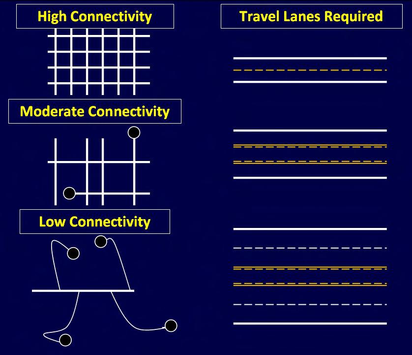
17 Planning elements that affect pedestrian safety: Land Use Street Connectivity Access Management Site Design Level of Service 1 17
18 Land Use 1 18

19 Why do we have cities? To minimize travel & maximize exchange (to be closer together) 1 19

20 How have we built our urban roadway system? To facilitate travel over longer distances 1 20

21 Reducing travel demand is best achieved changing Land Use policies that bring destinations closer together The problem: Commercial activities concentrated in autodominated corridors. Segregated land uses Result: long travel distances, not conducive to walking School 1 21

22 Reducing travel demand is best achieved changing Land Use policies that bring destinations closer together Potential solutions? Allow small scale retail in neighborhoods Create neighborhood parks Site school closer to residences & parks School 1 22

23 Neo traditional development: destinations are close to residential areas 1 23


24 Street Connectivity Connectivity creates a pedestrian friendly street system by: Reducing walking distances; Offering more route choices, more quiet local streets; Dispersing traffic reducing reliance on arterials for all trips 1 24


25 Connectivity creates a pedestrian friendly street system by: Reducing walking distances; Offering more route choices, more quiet local streets; Dispersing traffic reducing reliance on arterials for all trips 1 25

26 Can you increase connectivity with paths, greenways? Reduces walking distances: YES Offers more route choices: YES Reduces motor vehicle traffic: YES Disperses motor traffic: NO 1 26
27 1 27

28 Lack of connectivity => overly wide streets 1 28

29 Lack of connectivity => few but large intersections 1 29

30 Land Use & Connectivity Schools next to parks. Dedicate R.O.W. to link cul de sacs with linear parks 1 30

31 Access Management Every driveway is a potential conflict 1 31

32 Drivers and pedestrians must make choices: Walk in front or in back? Pull forward or back up? 1 32
 (2)")
 and (2) consolidate")
33 Access Management => fewer conflicts at driveways (1) (2) Two techniques: (1) median (no left turns) and (2) consolidate driveways 1 33

34 Driveways can be closed for safety 1 34

35 Severing public streets not a desirable access management technique This limits people s ability to walk or bicycle 1 35

36 Connecting severed streets reestablishes walking routes 1 36

37 Severed street can be reconnected for pedestrians 1 37
38 Site Design 1 38

39 Bringing Buildings closer to the Street Makes access for pedestrians safer and easier Creates a street where drivers know to expect pedestrians 1 39

40 Parking between sidewalk and building is not pedestrian friendly 1 40

41 Building at back of walk: pedestrian oriented design 1 41

42 Fast food typically favors drive thru over walk ins Pedestrians must cross drive thru lane 1 42

43 Alternative design: Direct pedestrian access is provided with no vehicular conflicts 1 43

44 Parking and drive through are still provided 1 44

45 Cars enter back here Even a gas station / convenience store can be built with pedestrian friendly design at back of walk 1 45

46 Accessible Parking Space Store Landscape Bulbout Ped Way Sidewalk Pedway retrofitted from sidewalk to building through parking 1 46

47 Same principles apply to large scale developments: Direct, safe & convenient access is provided 1 47
48 These goals are achieved by local ordinances, which must be enforced. They are beyond the scope of road designers, yet contribute greatly to the safety, comfort and aesthetics of the walking experience. Do your local ordinances support pedestrianoriented planning and design? 1 48
49 Rethinking The Role of Urban Streets 1 49
 Access to destinations Thriving businesses Beauty")
50 A complete street accommodates many uses and provides for all purposes of a street: Mobility (all modes) Access to destinations Thriving businesses Beauty 1 50

51 Transforming a street 1 51
52 Narrow lanes; add bike lanes, median, trees, texture 1 52
53 Bring in buildings that face the street 1 53
54 More buildings: Infill 1 54

55 The street now has life and is safer for pedestrians 1 55
56 The impact of Level of Service (LOS) standards on street design and pedestrian safety 1 56
57 HCM says LOS = A; little traffic, no impediments Result: very wide roads that reduce pedestrian safety 1 57
58 A new ped LOS is needed to reflect quality of walking experience HCM says ped LOS = A; few people walking 1 58

59 A new ped LOS is needed to reflect quality of walking experience HCM says ped LOS = F; too many peds! 1 59

60 Why are pedestrians at high risk on this street? Multi lane roadway, high speeds 1 60

61 Why are pedestrians at Low risk on this street? Narrow roadway, low speeds, busy 1 61

62 What is the core safety issue? Pedestrians and drivers must use the streets together What does the driver see that says slow down, watch for pedestrians? On street parking Narrow cross section Buildings close to street Sidewalks Crosswalk People! 1 62

63 Reinventing the roadway: Transform a 5 lane commercial strip to 1 63

64 Reinventing the roadway: a safer road for everyone Discussion Questions: What changed? What didn t change? 1 64
65 Let s Recap Why is it important to accommodate pedestrian safety and accessibility? How does the street environment influence drivers and pedestrians expectations and interactions? Where is the information? What planning factors influence pedestrian safety and accessibility? 1 65
66 Questions? 1 66
How to Develop a Pedestrian Safety Action Plan
 How to Develop a Pedestrian Safety Action Plan Course Introduction Presented by: Peter Eun FHWA RC Safety Engineer Ryan Snyder President, Ryan Snyder Associates, LLC Paul Zykofsky Director, Land Use and
DESIGNING FOR PEDESTRIAN SAFETY. Module 1
 DESIGNING FOR PEDESTRIAN SAFETY Module 1 Instructors: 1-2 Peter Eun FHWA Resource Center Transportation Safety Engineer peter.eun@dot.gov Michael J. Cynecki, PE Lee Engineering Project Manager MCynecki@lee-eng.com
Creating Complete Streets to Accommodate All Users
 Creating Complete Streets to Accommodate All Users Peter Lagerwey, Toole Design Group plagerwey@tooledesign.com Brian Dougherty, Seattle DOT brian.dougherty@seattle.gov International Conference on Urban
Built Environment Childhood Obesity Forum September 15, 2010
 Built Environment Childhood Obesity Forum September 15, 2010 TITLE Why do we have cities? Boston MA To minimize travel & maximize exchange (bring people closer together) How have we built our urban roadway
Pedestrian Safety. By Jerry Duke & Polly Carolin, FAICP for the Nevada Transportation Conference 2009
 Pedestrian Safety By Jerry Duke & Polly Carolin, FAICP for the Nevada Transportation Conference 2009 1 Presentation Overview Background Benefits Influencing Factors Barriers Pedestrian Safety Planning
Illustrated Principles of Good Planning
 Illustrated Principles of Good Planning The Miami 21 Zoning Code incorporates time-tested planning principles into the zoning regulations of our City. These are principles that make for better neighborhoods,
Retrofitting Urban Arterials into Complete Streets
 Retrofitting Urban Arterials into Complete Streets John N. LaPlante, P.E., P.T.O.E., T.Y. Lin International Prepared for: Illinois Traffic Engineering & Safety Conference Urbana, Illinois October 18, 2007
USDOT Bicycle and Pedestrian Safety Initiative: Safer People and Safer Streets. Barbara McCann, USDOT Office of Policy
 { USDOT Bicycle and Pedestrian Safety Initiative: Safer People and Safer Streets Barbara McCann, USDOT Office of Policy 4 Steps from policy to practice Creating multi-modal streets means: 1. Change Decision-Making
7 Complete Streets & Roadway Aesthetics
 7 Complete Streets & Roadway Aesthetics 7.1 OVERVIEW Our streets lay the foundation for how we interface with travel needs, physical exercise, social exchanges and access to goods and services. They are
REGIONAL BICYCLE AND PEDESTRIAN DESIGN GUIDELINES
 REGIONAL BICYCLE AND PEDESTRIAN DESIGN GUIDELINES November 16, 2011 Deb Humphreys North Central Texas Council of Governments Bicycle and Pedestrian Advisory Committee Snapshot of the Guide 1. Introduction
Prince George s County plans, policies, and projects
 Prince George s County plans, policies, and projects Over 250 projects for trails, bikeways, designated bike lanes and sidewalk construction Trail projects that improve access to Metro Sidewalk and trail
6/22/2018 VIA . Darcy Goulart, Planning Manager City of Rancho Cordova Planning Department 2729 Prospect Park Drive Rancho Cordova, CA 95670
 6/22/2018 VIA EMAIL Darcy Goulart, Planning Manager City of Rancho Cordova Planning Department 2729 Prospect Park Drive Rancho Cordova, CA 95670 RE: Quick Quack Car Wash (DD9801) Dear Ms. Goulart: WALKSacramento
and Rural Multimodal Networks 2017 ALTA PLANNING + DESIGN
 Small Town and Rural Multimodal Networks 2017 ALTA PLANNING + DESIGN SMALL TOWN AND RURAL MULTIMODAL NETWORKS GUIDE Why a Rural and Small Town Focused Guide? ONE SIZE DOES NOT FIT ALL. The new FHWA-endorsed
Transportation Planning Division
 Transportation Planning Division Presentation Outline Study Tasks Recap of Previous Meetings Data Collected Focus Areas within Study Limits Design Principles Tool Box Recommended Concepts Schedule Moving
6.4 RECOMMENDED IMPROVEMENTS
 6.4 RECOMMENDED IMPROVEMENTS 6.4.1 Williston Road Recommendations While all alternatives would be an improvement over existing conditions, Alternative 3B is recommended over the others because it provides
COWETA HIGH SCHOOL AND EAST HIGHWAY 51
 COWETA HIGH SCHOOL AND EAST HIGHWAY 51 Lack of sidewalks along Ben Lumpkin Rd. Lack of crosswalks and ramps at intersection. Hwy 51 is wide to cross as a pedestrian. No ADA compliance or connection to
5/31/2016 VIA . Arwen Wacht City of Sacramento Community Development Department 300 Richards Blvd., 3 rd Floor Sacramento, CA 95811
 5/31/2016 VIA EMAIL Arwen Wacht City of Sacramento Community Development Department 300 Richards Blvd., 3 rd Floor Sacramento, CA 95811 RE: El Pollo Loco (P16-028) Dear Ms. Wacht: WALKSacramento has reviewed
El Camino Real Specific Plan. TAC/CAC Meeting #2 Aug 1, 2018
 El Camino Real Specific Plan TAC/CAC Meeting #2 Aug 1, 2018 Land Use Alternatives Goals and Tradeoffs Parks & open space Housing Retail & services Civic spaces Parking Community gathering spaces 3 Alternatives
PBIC Webinar. How to Create a Bicycle Safety Action Plan: Planning for Safety [IMAGE] Oct. 2, 2014, 2 pm
![PBIC Webinar. How to Create a Bicycle Safety Action Plan: Planning for Safety [IMAGE] Oct. 2, 2014, 2 pm](/thumbs/86/93953441.jpg "PBIC Webinar. How to Create a Bicycle Safety Action Plan: Planning for Safety [IMAGE] Oct. 2, 2014, 2 pm") PBIC Webinar How to Create a Bicycle Safety Action Plan: Planning for Safety [IMAGE] Bill Schultheiss, Vice President, Toole Design Peter Lagerwey, Regional Director, Toole Design Oct. 2, 2014, 2 pm Today
PBIC Webinar How to Create a Bicycle Safety Action Plan: Planning for Safety [IMAGE] Bill Schultheiss, Vice President, Toole Design Peter Lagerwey, Regional Director, Toole Design Oct. 2, 2014, 2 pm Today
Report. Typical Sections. City of Middleton, WI
 Report Typical Sections City of Middleton, WI December 2006 Report for City of Middleton, Wisconsin Typical Sections repared by: Traffic Associates LLC and STRAND ASSOCIATES, INC. 910 West Wingra Drive
7/23/2017 VIA . Michael Hanebutt City of Sacramento Community Development Department 300 Richards Boulevard, 3 rd Floor Sacramento, CA 95811
 7/23/2017 VIA EMAIL Michael Hanebutt City of Sacramento Community Development Department 300 Richards Boulevard, 3 rd Floor Sacramento, CA 95811 RE: 65 th Street Apartments (DR17-220) Dear Mr. Hanebutt:
Transportation Planning Division
 Transportation Planning Division Presentation Outline Study Tasks Recap of Previous Meeting Stakeholder Interviews Data Collection Design Principles Tool Box Recommendations Schedule Moving Forward North
Designing for Pedestrians: An Engineering Symposium. Rutgers University March 21, 2013
 Designing for Pedestrians: An Engineering Symposium Rutgers University March 21, 2013 The Problem 2 Pedestrian Fatalities Pedestrian Fatalities by Year in US (1994-2010) 6000 5000 4000 3000 2000 1000 0
12/4/2016 VIA . RE: Grocery Outlet Del Paso (DR16-328)
") 12/4/2016 VIA EMAIL Ethan Meltzer, Assistant Planner City of Sacramento Community Development Department 300 Richards Blvd, 3 rd Floor Sacramento, CA 95811 RE: Grocery Outlet Del Paso (DR16-328) Dear Mr.
12/4/2016 VIA EMAIL Ethan Meltzer, Assistant Planner City of Sacramento Community Development Department 300 Richards Blvd, 3 rd Floor Sacramento, CA 95811 RE: Grocery Outlet Del Paso (DR16-328) Dear Mr.
Pedestrian & Bicycle Safety Innovations & Applications
 Pedestrian & Bicycle Safety Innovations & Applications County Engineers Association of Maryland Spring, 2017 Conference May 25, 2017 George Branyan Pedestrian Program Coordinator District Department of
Chapter 2: Standards for Access, Non-Motorized, and Transit
 Standards for Access, Non-Motorized, and Transit Chapter 2: Standards for Access, Non-Motorized, and Transit The Washtenaw County Access Management Plan was developed based on the analysis of existing
Does It Work? THE BENCHMARKING PROJECT. State Department of Transportation Project Assessment. Bill Wilkinson and Bob Chauncey
 THE BENCHMARKING PROJECT Does It Work? State Department of Transportation Project Assessment Bill Wilkinson and Bob Chauncey National Center for Bicycling & Walking 1506 21 st Street NW, Washington, DC
5/7/2013 VIA . RE: University Village Safeway Expansion (P13-019)
") 5/7/2013 VIA EMAIL David Hung, Associate Planner Community Development Department, Current Planning Division City of Sacramento 300 Richards Boulevard, 3 rd Floor Sacramento, CA 95811 RE: University Village
5/7/2013 VIA EMAIL David Hung, Associate Planner Community Development Department, Current Planning Division City of Sacramento 300 Richards Boulevard, 3 rd Floor Sacramento, CA 95811 RE: University Village
City of Novi Non-Motorized Master Plan 2011 Executive Summary
 City of Novi Non-Motorized Master Plan 2011 Executive Summary Prepared by: February 28, 2011 Why Plan? Encouraging healthy, active lifestyles through pathway and sidewalk connectivity has been a focus
APPENDIX A: Complete Streets Checklist DRAFT NOVEMBER 2016
 APPENDIX A: Complete Streets Checklist DRAFT NOVEMBER 2016 Complete Streets Checklist MetroPlan Orlando s Complete Streets Checklist is an internal planning tool for staff to further implementation of
2015 Florida Main Street Annual Conference. Complete Streets Equal Stronger Main Streets
 WHAT ARE COMPLETE STREETS? CASE STUDIES COMPLETING YOUR MAIN STREET 2015 Florida Main Street Annual Conference St. Petersburg, Florida August 19, 2015 WHAT ARE COMPLETE STREETS? CASE STUDIES COMPLETING
Pedestrians safety. ROAD SAFETY SEMINAR PIARC/AGEPAR/GRSP Lome, Togo October 2006 Lise Fournier, Canada-Qu
 Pedestrians safety ROAD SAFETY SEMINAR Lome, Togo October 2006 Lise Fournier, Canada-Qu Québec Contents WHO s data Risk factors Pedestrian needs Pedestrian facilities Conclusion Source: WHO WHO reports
Streets. Safe for Pedestrians 20% 2nd 5,000. Are We People-Friendly?
 Streets Safe for Pedestrians 20% Pedestrian deaths account for more than of all traffic-related fatalities in California each year. 600 More than people are killed and another 13,000 are injured every
RESOLUTION NO ?? A RESOLUTION OF THE CITY OF NEPTUNE BEACH ADOPTING A COMPLETE STREETS POLICY
 RESOLUTION NO. 2018-?? A RESOLUTION OF THE CITY OF NEPTUNE BEACH ADOPTING A COMPLETE STREETS POLICY WHEREAS, safe, convenient, and accessible transportation for all users is a priority of the City of Neptune
Multimodal Through Corridors and Placemaking Corridors
 68 Multimodal Through Corridors and Placemaking Corridors Corridors have different functions in a region. Some corridors are used to get smoothly and rapidly through a region or to get quickly to major
This page intentionally left blank.
 This page intentionally left blank. COMMUNITY Coweta Community Overview Coweta Coweta, a residential community located in Wagoner County, is a suburb of Tulsa situated southeast of the metropolitan area
Approaches. Livable Neighborhood Design. Examples. Traditional neighborhood development. CE 594 University of Wisconsin- Milwaukee
 Approaches Livable Neighborhood Design CE 594 University of Wisconsin- Milwaukee Traditional neighborhood design (TND), new urbanism, transit friendly design, transit oriented development and walkable
DOWNTOWN MIAMI PEDESTRIAN PRIORITY ZONE
 DOWNTOWN MIAMI PEDESTRIAN PRIORITY ZONE AUGUST 6, 2013 DOWNTOWN MIAMI BY THE NUMBERS more than 200,000 people live, work, and play here every day is home to more than 1,000 events each year hosts more
5 CIRCULATION AND STREET DESIGN
 5 CIRCULATION AND STREET DESIGN This chapter describes circulation and streetscape improvements proposed for the Northwest Chico Specific Plan Area. It includes detailed design specifications for existing
Intersection Improvement: Sturgeon Road, Silver Avenue and Murray Park Road Roundabout. Welcome. Public Information Session
 Intersection Improvement: 1 Welcome WHY IS AN INTERSECTION IMPROVEMENT NEEDED? 2 Traffic volumes for Sturgeon Road, Silver Avenue and Murray Park Road exceed the capacity of the existing 4-way stop controlled
COMPLETE STREETS PLANNER S PORTFOLIO
 COMPLETE STREETS PLANNER S PORTFOLIO ISSUE 3 APRIL 2016 PLANNER S PORTFOLIO COMPLETE STREETS 1 2 6 10 14 OVERVIEW MATURE NEIGHBORHOODS GROWING SUBURBS CENTRAL PLACES ACTIVITY CORRIDORS Planner s Portfolio
G AT E WAY PLAN. Community BRIEFING KIT GATEWAY BIKE
 G AT E WAY PLAN GATEWAY BIKE Community BRIEFING KIT PLAN August 2016 TABLE OF CONTENTS INTRODUCTION... 1 THE BENEFITS OF A BIKEABLE COMMUNITY... 2 ECONOMY...2 SAFETY...3 HEALTH...3 HOUSEHOLD SPENDING...3
11/3/2014 VIA . WALKSacramento has reviewed the Stockton and T Mixed-Use project at 3675 T Street in the
 11/3/2014 VIA EMAIL Antonio Ablog Planning Department City of Sacramento 300 Richards Boulevard Sacramento, CA 95811 RE: Design Review for Stockton and T Mixed-Use (P14-042) Dear Mr. Ablog: WALKSacramento
2014 Wisconsin Tribal Transportation Conference. Matt Halada Transportation Planner NE Region
 2014 Wisconsin Tribal Transportation Conference Matt Halada Transportation Planner NE Region Implementing Wisconsin s Pedestrian and Bicycle Accommodations Law (Complete Streets) Tools and methods for
Executive Summary Route 30 Corridor Master Plan
 Route Corridor Master Plan Project Overview The Route Corridor Master Plan is a coordinated multimodal transportation and land use plan for the entire stretch of Route through East Whiteland Township,
Active Transportation Facility Glossary
 Active Transportation Facility Glossary This document defines different active transportation facilities and suggests appropriate corridor types. Click on a facility type to jump to its definition. Bike
AMATS Complete Streets Policy
 AMATS Complete Streets Policy Table of Contents: Section 1. Definition of Complete Streets Section 2. Principles of Complete Streets Section 3. Complete Streets Policy Section 4. Consistency Section 5.
Albany Shaker Road Corridor Study Public Meeting # 2
 Albany Shaker Road Corridor Study Public Meeting # 2 Scope / Meeting Purpose This project is a CDTC Linkage Study. The Linkage Program is designed to implement the adopted planning and investment principles
Chapter 5. Complete Streets and Walkable Communities.
 Chapter 5. Complete Streets and Walkable Communities. 5.1 Description of Complete Streets. Cities throughout the world, and specifically the United States, are coming to embrace a new transportation and
8/31/2016 VIA . RE: Freeport Arco Fuel Station (P16-039)
") 8/31/2016 VIA EMAIL Garrett Norman, Assistant Planner City of Sacramento Community Development Department 300 Richards Boulevard, 3 rd Floor Sacramento, CA 95811 RE: Freeport Arco Fuel Station (P16-039)
8/31/2016 VIA EMAIL Garrett Norman, Assistant Planner City of Sacramento Community Development Department 300 Richards Boulevard, 3 rd Floor Sacramento, CA 95811 RE: Freeport Arco Fuel Station (P16-039)
City of Wilsonville 5 th Street to Kinsman Road Extension Project
 City of Wilsonville 5 th Street to Kinsman Road Walking Tour & Neighborhood Workshop Summary Report Public Outreach Overview On July 18 th, 2017, the City of Wilsonville hosted a neighborhood walking tour
10/8/2014 VIA . RE: CVS Pharmacy (P13-002) Revised August 2014
 Revised August 2014") 10/8/2014 VIA EMAIL David Hung, Associate Planner Community Development Department, Current Planning Division City of Sacramento 300 Richards Boulevard, 3 rd Floor Sacramento, CA 95811 RE: CVS Pharmacy
10/8/2014 VIA EMAIL David Hung, Associate Planner Community Development Department, Current Planning Division City of Sacramento 300 Richards Boulevard, 3 rd Floor Sacramento, CA 95811 RE: CVS Pharmacy
6/14/2013 VIA . Evan Compton, Associate Planner Community Development Department City of Sacramento 300 Richards Blvd Sacramento, CA 95814
 6/14/2013 VIA EMAIL Evan Compton, Associate Planner Community Development Department City of Sacramento 300 Richards Blvd RE: Sacramento Natural Foods Co-Op (P13-025) Dear Mr. Compton: WALKSacramento appreciates
Designing Complete Streets: What you need to know
 Designing Complete Streets: What you need to know Getting from this to this. Continuous sidewalk Buffer w/trees Bicycle lane Raised median Buildings close to the street Flexibility in design Design and
Memo. Ocean Avenue Corridor Design Project Public Workshop #2 Summary
 Ocean Avenue Corridor Design Project Public Workshop #2 Summary The second public workshop for the Ocean Avenue Corridor Design Project was held on Wednesday, May 14, 2014 from, 6 to 8 pm at Lick Wilmerding
CONTEXT SENSITIVE STREETS STANDARDS COMMITTEE
 CONTEXT SENSITIVE STREETS STANDARDS COMMITTEE February 23, 2015 Prepared by: Denise Chaplick, AICP City Jacksonville Bicycle and Pedestrian Coordinator Source: NCDOT Complete Streets Planning and Design
Why Zone In on Speed Reduction?
 Learn it. Do it. Live it! SPEED REDUCTION IN THE ZONE Why Zone In on Speed Reduction? Speeding is a serious issue that plays a major role in the risk of serious injury and pedestrian fatality in a crash.
TOWN OF PORTLAND, CONNECTICUT COMPLETE STREETS POLICY
 TOWN OF PORTLAND, CONNECTICUT COMPLETE STREETS POLICY I. VISION, GOALS & PRINCIPLES VISION To improve the streets of Portland making them safer and more accessible for all users including pedestrians,
9/22/2014 VIA . RE: Butano Apartments Pre App (PAMP )
") 9/22/2014 VIA EMAIL Surinder Singh, Senior Planner Planning and Environmental Review Division Sacramento County 827 7th Street, Second Floor RE: Butano Apartments Pre App (PAMP2014-00012) Dear Mr. Singh:
9/22/2014 VIA EMAIL Surinder Singh, Senior Planner Planning and Environmental Review Division Sacramento County 827 7th Street, Second Floor RE: Butano Apartments Pre App (PAMP2014-00012) Dear Mr. Singh:
MAKE YOUR PLACE IN CHANNELSIDE
 MAKE YOUR PLACE IN CHANNELSIDE INTRODUCTION PROJECT LIMITS Channelside Drive from Cumberland Ave to Kennedy Boulevard EXISTING CONDITIONS EXISTING CONDITIONS CHANNELSIDE DRIVE FROM E. CUMBERLAND AVENUE
Randy Neufeld National Complete Streets Coalition. September 8, 2008
 1 Randy Neufeld National Complete Streets Coalition September 8, 2008 2 National Complete Streets Coalition Steering Committee AARP Association of Pedestrian and Bicycle Professionals Active Living by
11/28/2016 VIA
 11/28/2016 VIA EMAIL Ethan Meltzer, Assistant Planner City of Sacramento Community Development Department 300 Richards Blvd., 3 rd Floor Sacramento, Ca 95811 RE: Natomas Corporate Center Commercial Building
San Jose Transportation Policy
 San Jose Transportation Policy Protected Intersections in LOS Policies to Support Smart Growth Presented by: Manuel Pineda City of San Jose Department of Transportation Bay Area Map San Francisco Oakland
Appendix C. TRAFFIC CALMING PROGRAM TOOLBOX
 Appendix C. TRAFFIC CALMING PROGRAM TOOLBOX PHASE I...2 Do Not Enter Sign...3 One-Way Sign...4 Turn Prohibition...5 Pavement Markings...6 Speed Monitoring Trailer...7 Neighborhood Speed Watch...8 Police
Perryville TOD and Greenway Plan
 Perryville TOD and Greenway Plan Greenway Glossary Pathway: A bicycle and pedestrian path separated from motorized vehicular traffic by an open space, barrier or curb. Multi-use paths may be within the
Toward Zero Deaths. Regional SHSP Road Show Meeting. Virginia Strategic Highway Safety Plan. presented by
 Toward Zero Deaths Regional SHSP Road Show Meeting presented by Virginia Strategic Highway Safety Plan December 1, 2016 1 Welcome & Introductions Purpose of the Meeting Objectives & Key Outcomes Agenda»
3/10/2016 VIA th Street, Suite 203 Sacramento, CA
 3/10/2016 VIA EMAIL Arwen Wacht, Associate Planner City of Sacramento Community Development Department 300 Richards Boulevard, 3 rd Floor Sacramento, CA 95811 RE: Natomas Fountains (P16-012) Dear Ms. Wacht:
Vision: Traditional hamlet with an attractive business/pedestrian friendly main street connected to adjacent walkable neighborhoods
 N D. Focus Area II Vision: Traditional hamlet with an attractive business/pedestrian friendly main street connected to adjacent walkable neighborhoods Transit Road Focus Area II is located in the Hamlet
A CHANGING CITY. of Edmonton, it is essential that it reflects the long-term vision of the City.
 A CHANGING CITY By the year 2040, Edmonton will be home to more than 1 million people. To accommodate growth and support a healthy and compact city, we need a new approach to development/redevelopment
Montford Drive Parking & Circulation Study
 Montford Drive Parking & Circulation Study Parking & Circulation Study Follow up to the Area Plan based on what we heard Purpose 1 2 3 4 To look closer and evaluate parking and network related issues (including
Madison Urban Area and Dane County. Bicycle Transportation Plan Summary. September Introduction. Bicycle Plan Scope and Planning Process
 Bicycle Transportation Plan Summary Madison Urban Area and Dane County Introduction September 2000 Bicycling is an important mode of transportation in the Madison urban area and countywide that is available
Pine Hills Road Pedestrian/Bicycle Safety Study Board of County Commissioners Work Session
 Pine Hills Road Pedestrian/Bicycle Safety Study Board of County Commissioners Work Session February 20, 2018 Meeting Agenda Study Overview Existing Conditions Access Management Potential Gateway Features
GIS Based Data Collection / Network Planning On a City Scale. Healthy Communities Active Transportation Workshop, Cleveland, Ohio May 10, 2011
 The Purpose of GIS Based Network Planning GIS Based Data Collection / Network Planning Healthy Communities Active Transportation Conference Tuesday, May 10, 2011 10:00 AM Norman Cox, LLA, ASLA. Ann Arbor,
Dr. M.L. King, Jr. Street North Complete Streets Resurfacing Opportunities HOUSING, LAND USE, AND TRANSPORTATION COMMITTEE MARCH 22, 2018
 Dr. M.L. King, Jr. Street North Complete Streets Resurfacing Opportunities HOUSING, LAND USE, AND TRANSPORTATION COMMITTEE MARCH 22, 2018 What s Happening The City plans to mill and resurface Dr. M.L.
9/21/2016 VIA . RE: The Knot (DR16-270)
") 9/21/2016 VIA EMAIL Garrett Norman, Assistant Planner City of Sacramento Community Development Department 300 Richards Boulevard, 3 rd Floor Sacramento, CA 95811 RE: The Knot (DR16-270) Dear Mr. Norman:
9/21/2016 VIA EMAIL Garrett Norman, Assistant Planner City of Sacramento Community Development Department 300 Richards Boulevard, 3 rd Floor Sacramento, CA 95811 RE: The Knot (DR16-270) Dear Mr. Norman:
Land Use Patterns. Traditional Modern
 Street Types Pre WWII: tight street grid, straight connected streets, sidewalks and alleys, block size 400 or < Post WWII: curvilinear streets, cul-de-sacs, few sidewalks, large blocks at 600 or > and
M-58 HIGHWAY ACCESS MANAGEMENT STUDY Mullen Road to Bel-Ray Boulevard. Prepared for CITY OF BELTON. May 2016
 M-58 HIGHWAY ACCESS MANAGEMENT STUDY Prepared for CITY OF BELTON By May 2016 Introduction Missouri State Highway 58 (M-58 Highway) is a major commercial corridor in the City of Belton. As development has
Town of Babylon Sustainable Complete Streets Policy
 Town of Babylon Sustainable Complete Streets Policy Steve Bellone, Supervisor Adopted July 14, 2010 1 Table of Contents Vision... 3 Policy Statement... 3 Definition... 3 Road Users... 4 Network... 4 Roads...
Arlington s Master Transportation Plan
 Arlington s Master Transportation Plan The Master Transportation Plan (MTP) Adopted in eight parts Goals & Policies element and MTP Map adopted in 2007 Bicycle, Pedestrian and Demand and Systems Management
Physical Implications of Complete Streets Policies
 Presentation Overview Physical Implications of Complete Norm Cox, ASLA, LLA Landscape Architect Ann Arbor, Michigan, 10:45 to Noon What Are Complete Streets? What Matters to Bicyclists and Pedestrians
CONNECTING PEOPLE TO PLACES
 CONNECTING PEOPLE TO PLACES 82 EAST BENCH MASTER PLAN 07 Introduction The East Bench transportation system is a collection of slow moving, treelined residential streets and major arteries that are the
City of Vallejo Traffic Calming Toolbox
 City of Vallejo Traffic Calming Toolbox June 1, 2013 Final Table of Contents Introduction... 1 Non-Physical Devices... 3 High-Visibility Crosswalk... 3 In Pavement Lighted Crosswalk... 4 Rapid Flashing
Ocean Park Boulevard Green Street Project Alternatives & Trade Offs
 Planning Commission March 4, 2009 Ocean Park Boulevard Green Street Project Alternatives & Trade Offs Purpose of Tonight s Meeting Review concept plans and options Provide input on alternatives and trade-offs
Safety & Convenience for All Users, in All Modes. Barbara McCann NCSL December 3, 2013
 Safety & Convenience for All Users, in All Modes Barbara McCann NCSL December 3, 2013 Safety & Convenience for All Users? Who was left out when this road was planned? Takaaki Iwabu for Raleigh News Observer
Solana Beach Comprehensive Active Transportation Strategy (CATS)
") Solana Beach Comprehensive Active Transportation Strategy (CATS) 3.0 Goals & Policies The Solana Beach CATS goals and objectives outlined below were largely drawn from the Solana Beach Circulation Element
Solana Beach Comprehensive Active Transportation Strategy (CATS) 3.0 Goals & Policies The Solana Beach CATS goals and objectives outlined below were largely drawn from the Solana Beach Circulation Element
Potential Bicycle Facility on Bayou Street Mobile, Alabama
 Potential Bicycle Facility on Bayou Street Mobile, Alabama By Richard A. Hall, P.E. Prepared For Mobile Downtown Alliance Hall Planning & Engineering, Inc. March 28, 2018 Introduction Review of the February
Long Island Rail Road Expansion Project Floral Park to Hicksville
 Long Island Rail Road Expansion Project Floral Park to Hicksville Final Environmental Impact Statement Appendix 1-D Complete Streets Policy Checklist April 2017 0902ML PIN: Project Location: 18A-4 Floral
Ann Arbor Downtown Street Plan
 1 Ann Arbor Downtown Street Plan Public Workshop #1 We know that. 2 Public right-of-way (streets, sidewalks, and alleys) make up 30% of the total District area of downtown. Streets need to provide mobility
Living Streets Policy
 Living Streets Policy Introduction Living streets balance the needs of motorists, bicyclists, pedestrians and transit riders in ways that promote safety and convenience, enhance community identity, create
What Is a Complete Street?
 Session 5 Charleen Zimmer, AICP, Zan Associates May 5-7, 2010 What Is a Complete Street? May 2010 5-1 Not a Complete Street More of a Complete Street May 2010 5-2 Benefits of Complete Streets Safety for
We believe the following comments and suggestions can help the department meet those goals.
 The Honorable Secretary Anthony Foxx The Secretary of Transportation United States Department of Transportation 1200 New Jersey Avenue, SE Washington, DC 20590 August 30, 2013 Dear Secretary Foxx, Thank
Health and the Built Environment Presentation to the Childhood Obesity Conference
 Presentation to the Childhood Obesity Conference By Cole Runge, Principal Planner Brown County Planning Commission September 29, 2011 The built environment strongly influences physical and mental health.
STEERING COMMITTEE MEETING June 17, Streetscape Overview Burlington Comprehensive Master Plan
 STEERING COMMITTEE MEETING June 17, 2015 Streetscape Overview Burlington Comprehensive Master Plan 1 Introduction Slide This slide show was presented to the Burlington Steering Committee on June 17, 2015
ROUNDABOUTS/TRAFFIC CIRCLES
 GENERAL 1. Description This standard identifies minimum requirements that shall be met for Roundabouts and Neighborhood Traffic Circles in the design and construction of elements for Arlington County Horizontal
Corpus Christi Metropolitan Transportation Plan Fiscal Year Introduction:
 Introduction: The Safe, Accountable, Flexible, Efficient Transportation Equity Act: A Legacy for Users (SAFETEA-LU) has continued the efforts started through the Intermodal Surface Transportation Efficiency
Toward Zero Deaths: Strategies for Pedestrian and Bicycle Professionals
 Toward Zero Deaths: Strategies for Pedestrian and Bicycle Professionals [IMAGE] Charlie Zegeer, PBIC Carl Sundstrom, PBIC Jan. 31, 2013, 2 pm Today s Presentation Introduction and housekeeping Audio issues?
Proposed. City of Grand Junction Complete Streets Policy. Exhibit 10
 Proposed City of Grand Junction Complete Streets Policy Exhibit 10 1 City of Grand Junction Complete Streets Policy Vision: The Complete Streets Vision is to develop a safe, efficient, and reliable travel
This page intentionally left blank.
 This page intentionally left blank. COMMUNITY Catoosa Community Overview Catoosa Catoosa is a city of just over 7,000 residents adjacent to the northeast border of Tulsa. The city contains two major regional
Designing for Pedestrian Safety
 Designing for Pedestrian Safety Intersection Geometry Presented by: John LaPlante T.Y. Lin International, Inc Keith Sinclair FHWA Resource Center September 9, 2010 Learning Outcomes At the end of this
Section 8. Partnerships and Funding
 This section discusses the potential partnership and funding options that the Town should consider in order to assist with the implementation of the recommendations provided in the Plan. Section 8. Partnerships