PUBLIC REALM MASTER PLAN
|
|
|
- Cecil Peters
- 5 years ago
- Views:
Transcription

1 WESTSHORE BUSINESS DISTRICT PUBLIC REALM MASTER PLAN MASTER PLAN COMMITTEE MEETING MARCH 20, 2013


2 WESTSHORE BUSINESS DISTRCT PUBLIC REALM MASTER PLAN MACRO-SCALE CONCEPT: A PUBLIC REALM FRAMEWORK DEFINED BY A CONNECTED SYSTEM OF PATHS AND PLACES THE WESTSHORE LOOP CONNECTIVITY FRAMEWORK FRAMEWORK DEFINITION REINFORCED THROUGH THOROUGHFARE STREETSCAPE ENHANCEMENTS AND STRATEGIC PLACEMENT OF NEW PUBLIC SPACES

3 WESTSHORE BUSINESS DISTRICT PUBLIC REALM MASTER PLAN
")
4 WESTSHORE BOULEVARD: EXISTING CONTEXTUAL CONDITIONS THOROUGHFARE LENGTH IN FOCUS AREA: 1.1 mi. NORTH OF INTERSTATE 275 FOUR VEHICULAR LANES 45 mph SPEED LIMIT ASYMMETRICAL STREET CONDITONS NO PUBLIC SPACE OR PEDESTRIAN AMENITIES 5 SIDEWALKS (WITH OCCASIONAL INFRASTRUCTURE OBSTRUCTIONS) CONTIGUOUS FRONTAGE PARKING ON BOTH SIDES OF THE STREET NO INTERACTION BETWEEN BUILDINGS AND SIDEWALKS LACK OF PUBLIC SPACE AMD PEDESTRIAN AMENITIES SOUTH OF INTERSTATE 275 SIX VEHICULAR LANES 45 mph SPEED LIMIT ASYMMETRICAL STREET CONDITIONS NO PUBLIC SPACE OR PEDESTRIAN AMENITIES 5 SIDEWALKS (WITH OCCASIONAL INFRASTRUCTURE OBSTRUCTIONS) LACK OF PUBLIC SPACE AMD PEDESTRIAN AMENITIES

5 WESTSHORE BOULEVARD: PROPOSED PUBLIC REALM ENHANCEMENTS
 Lowered speed limit (35 MPH) Widened sidewalks (10 0 min.")
 SOUTH OF")
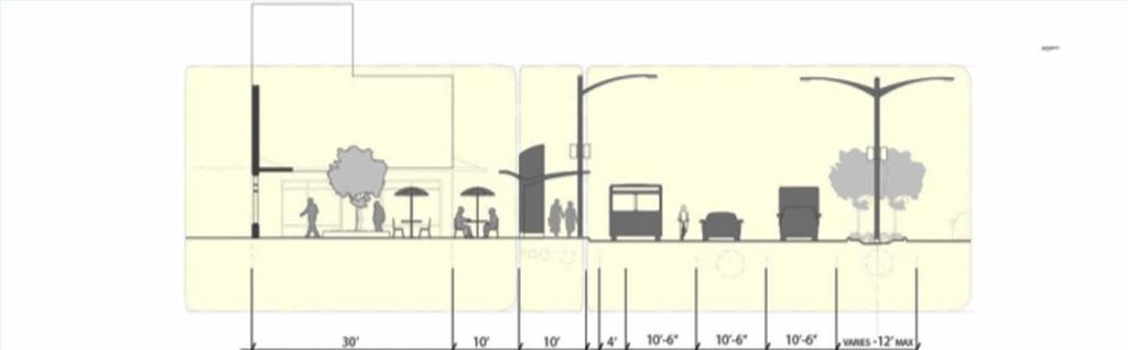
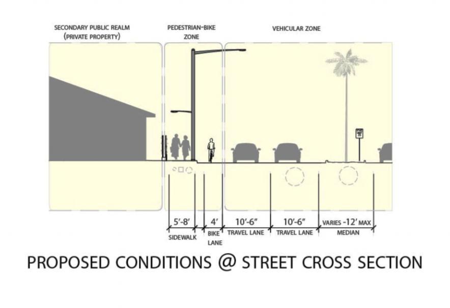
6 ENVISIONED PUBLIC REALM ENHANCEMENTS AT WESTSHORE BOULEVARD PROPOSED RIGHT OF WAY MODIFICATIONS AND STREETSCAPE CONDITIONS: NORTH OF INTERSTATE 275 Vehicular lane narrowing ( 10 6 ) Lowered speed limit (35 MPH) Widened sidewalks (10 0 min.) Shared bus and bicycle lanes Landscaped medians Sidewalk enhancements: street trees, paver brick accents, concrete patterning & bioswales (where possible) Intersection enhancements and pavement markings Street furnishings and pedestrian amenities New open space features Parking lot screening (4 x 10 temporary living wall panels) SOUTH OF INTERSTATE 275 All of the above FLEX Lanes outside vehicular lanes (convertible for bus, bicycle and evening/weekend on street parking)

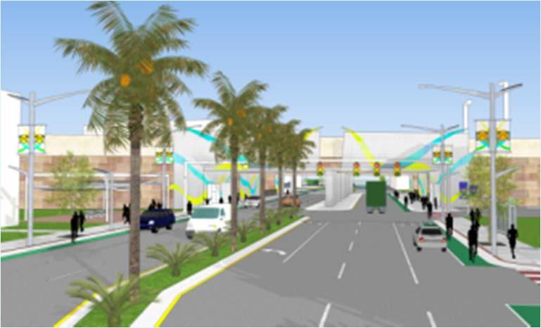
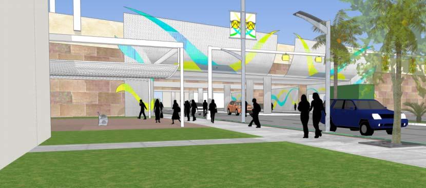
7 ENVISIONED PUBLIC REALM CONDITIONS AT I-275/WESTSHORE BOULEVARD BRIDGE UNDERPASS

8

9 KENNEDY BOULEVARD: EXISTING CONTEXTUAL CONDITIONS THOROUGHFARE LENGTH IN FOCUS AREA: 1.5 mi. SIX VEHICULAR LANES 45 mph SPEED LIMIT NO INTERACTION BETWEEN BUILDINGS AND SIDEWALKS PARTIAL CONTIGUOUS FRONTAGE PARKING LACK OF PUBLIC SPACE AND PEDESTRIAN AMENITIES 5 SIDEWALKS

10 KENNEDY BOULEVARD: PROPOSED PUBLIC REALM ENHANCEMENTS
 Lowered speed limit (35 MPH) Widened sidewalks (10 0 min.")

11 ENVISIONED PUBLIC REALM CONDITIONS AT KENNEDY BOULEVARD PROPOSED RIGHT OF WAY MODIFICATIONS AND STREETSCAPE CONDITIONS: Vehicular lane narrowing ( 10 6 ) Lowered speed limit (35 MPH) Widened sidewalks (10 0 min.) Bicycle lanes Landscaped medians Sidewalk enhancements: street trees, paver brick accents & concrete patterning Intersection enhancements and pavement markings Street furnishings and pedestrian amenities New open space features Parking lot screening (48 x 10 temporary living wall panels)


12


13 LOIS AVENUE: EXISTING CONTEXTUAL CONDITIONS THOROUGHFARE LENGTH IN FOCUS AREA: 1.5 mi. SIX VEHICULAR LANES 45 mph SPEED LIMIT NEIGHBORHOOD STREET CONDITONS NO PUBLIC SPACE OR PEDESTRIAN AMENITIES 5 SIDEWALKS (WITH OCCASIONAL INFRASTRUCTURE OBSTRUCTIONS)

14 LOIS AVENUE: PROPOSED PUBLIC REALM ENHANCEMENTS

15 ENVISIONED PUBLIC REALM CONDITIONS AT LOIS AVENUE
16


17 ENVISIONED PUBLIC REALM CONDITIONS AT I-275/LOIS AVENUE BRIDGE UNDERPASS

18 CYPRESS STREET: EXISTING CONTEXTUAL CONDITIONS THOROUGHFARE LENGTH IN FOCUS AREA: 2.3 mi. FOUR VEHICULAR LANES 45 mph SPEED LIMIT NO INTERACTION BETWEEN BUILDINGS AND SIDEWALKS VARIED BUILDING FRONTAGE CONDITIONS VARIED SIDEWALK WIDTHS

19 CYPRESS STREET: PROPOSED PUBLIC REALM ENHANCEMENTS


20 ENVISIONED PUBLIC REALM CONDITIONS AT CYPRESS STREET/WESTSHORE BOULEVARD INTERSECTION

21 ENVISIONED PUBLIC REALM CONDITIONS AT CYPRESS STREET/WESTSHORE BOULEVARD INTERSECTION

22 ENVISIONED PUBLIC REALM CONDITIONS AT I-275/CYPRESS STREET BRIDGE UNDERPASS

23 DALE MABRY HIGHWAY: EXISTING CONTEXTUAL CONDITIONS THOROUGHFARE LENGTH IN FOCUS AREA: 1.5 mi. SIX VEHICULAR LANES; R.O.W. 4O 45 mph SPEED LIMIT VARIED STREET CONDITONS NO PUBLIC SPACE OR PEDESTRIAN AMENITIES 5 SIDEWALKS NO INTERACTION BETWEEN BUILDINGS AND SIDEWALKS

24 DALE MABRY HIGHWAY: PROPOSED PUBLIC REALM ENHANCEMENTS


25 ENVISIONED PUBLIC REALM CONDITIONS AT I-275/DALE MABRY HIGHWAY

26 ENVISIONED PUBLIC REALM CONDITIONS AT DALE MABRY HIGHWAY COMMERCIAL CENTER COMMERCIAL CENTER PUBLIC SPACES PEDESTRIAN BRIDGE PEDESTRIAN AMENITIES

27 ENVISIONED PUBLIC REALM CONDITIONS AT DALE MABRY HIGHWAY COMMERCIAL CENTER

28 BOYSCOUT BOULEVARD: EXISTING CONTEXTUAL CONDITIONS THOROUGHFARE LENGTH IN FOCUS AREA: 1.3 mi. SIX VEHICULAR LANES; VARIED R.O.W. WIDTH mph SPEED LIMIT VARIED STREET CONDITONS NO PUBLIC SPACE OR PEDESTRIAN AMENITIES

29 BOY SCOUT BOULEVARD: PROPOSED PUBLIC REALM ENHANCEMENTS

30 ENVISIONED PUBLIC REALM CONDITIONS AT BOY SCOUT BOULEVARD: OPEN SPACE DAILY ACIVITIES PEDESTRIAN BRIDGE OVER BOY SCOUT PUBLIC PLAZA/EVENT SPACE PEDESTRIAN BRIDGE TO INTERNATIONAL PLAZA

31 ENVISIONED PUBLIC REALM CONDITIONS AT BOY SCOUT BOULEVARD: OPEN SPACE SPECIAL EVENT


32 ENVISIONED PUBLIC REALM CONDITIONS AT BOY SCOUT BOULEVARD

33 ENVISIONED PUBLIC REALM CONDITIONS AT BOY SCOUT BOULEVARD


34 EXPANDING THE PUBLIC REALM: INCREMENTAL ROADWAY MODIFICATIONS (TYPICAL CONDITIONS ON A 100 FT. + R.O.W.) EXISITING CONDITIONS: LIMITED SIDEWALK WIDTHS; UNSAFE PEDESTRIAN CONDITIONS; HIGH SPEED LIMITS; WIDE VEHICLE TRAVEL LANES


35 PHASE 1 INTERVENTIONS: ROADWAY RE STRIPING; NEW BIKE LANES; PARKING LOT SCREENING; REDUCED SPEED LIMITS; PEDESTRIAN AMENITIES
 & PLANTED MEDIANS;")

36 PHASE 2 INTERVENTIONS: WIDENED SIDEWALKS; INTRODUCTION OF SIDEWALK PLANTERS (BIO SWALES) & PLANTED MEDIANS; STREETSCAPE ENHANCEMENTS; NEW SECONDARY INFRASTRUCTURE AND VISUAL ELEMENTS; STREET TREES AND OTHER LANDSCAPE FEATURES


37 PHASE 3 INTERVENTIONS: INTRODUCTION OF NEW PUBLIC SPACES; NEW SHADE/BUS SHELTER STRUCTURES; PEDESTRIAN AMENITIES; LANDSCAPE FEATURES; PUBLIC ART; COMPLETE STREET CONDITIONS
38 PROPOSED AREA-WIDE PEDESTRIAN AMENITIES, STREETSCAPE FURNISHINGS AND TYPICAL PUBLIC REALM FEATURES

39 WESTSHORE BOULEVARD PEDESTRIAN AMENITIES Solar panels on roof of shade structure to power LED lighting and interactive kiosk. Bench seating Translucent roofing to provide shade in the day time, as well as rain protection. Can be lit in the evening to create dynamic sense of place. Bike Arc storage. Compact way to store bikes in the public realm. Also has opportunity for bike share program. Multiuse interactive kiosk. Would contain touch screen route information. It would also contain public amenities such as: ticket purchase, water refill station, electronics charger, wifi connection, and other consumer related services Usage of all street furniture to create a sense of place on corridor. Westshore consists of vibrant colors, LED lighting, interactivity, and progressive forms. Installation of bioswale. Bioswale will allow for more filtration of water into the water table before reaching the river

40 KENNEDY BOULEVARD PEDESTRIAN AMENITIES Translucent panels to provide shade in the day yet allow for complete vision. Low hedges for buffering parking lots Street furniture to have cohesive visual elements. Blade sign to provide way Point instructions and continue vertical emphasis Pedestrian walkway is on average 5 feet wide (at current). Right of way allows for another 3 4 feet to be added. All furniture is narrow to allow maximum pedestrian movement. Bollards installed in front of shade structure to provide lighting and safety.

41 KENNEDY BOULEVARD PEDESTRIAN AMENITIES Solar panels to power the LED and feed back into power grid when possible Large signage to create map of points of interest and advertising for both pedestrians and vehicular. Branding taken from Ray James Stadium profile. Strong verticals with angled top portions. Contain LED lighting for night place making. Solid roofing for pedestrian shade device Thick bollards chosen to provide pedestrian lighting at night and sense of strength Blade signage for pedestrian wayfinding Wide and fast paced traffic on street, all elements are made to exude strength and safety on walkways


42 COORDINATED STREET FURNISHINGS: LIGHT BOLLARD, BIKE RACK, REFUSE BIN, AND BENCH SHADE STRUCTURES WITH SOLAR PANELS COMBINED BUS & SHADE STRUCTURE WITH INTERACTIVE INFORMATION KIOSK PEDESTRIAN WAYFINDING SIGNAGE ROADWAY GATEWAY ELEMENT ROADWAY SIGNAGE STANDARDS PEDESTRIAN AND ROADWAY LIGHT STANDARDS INTEGRATED SOLAR PANELS EXAMPLE OF LIVING WALL PARKING LOT SCREEN


43 DESIGN ALTERNATIVES: BUS SHELTERS; SHADE STRUCTURES; SECONDARY ELEMENTS


44 INTERSECTION AND SIEDEWALK ENHANCEMENTS INTERSECTION DEFINITION AT TWO WIDE THOROUGHFARES INTERSECTION DEFINITION AT WIDE THOROUGHFARE AND SIDE STREET


45 ENVISIONED TYPICAL PUBLIC REALM CONDITIONS: PEDESTRIAN-FRIENDLY, SAFE, VISUALLY ATTRACTIVE, COMPLETE STREET CONDITIONS FUTURE BUILDINGS WITH GROUND FLOOR ACTIVE USES PEDESTRIAN REALM AMENITIES AND ENHANCEMENTS SIDEWALK PLANTERS (BIO SWALES) SHARED ROADWAY CONDITIONS FOR VEHICLES, BICYCLISTS AND TRANSIT LIVING WALL PARKING LOT SCREENS COORDINATED SIGN STANDARDS REDUCED NUMBER OF CURB CUTS AND SHARED PARKING INTERACTION BETWEEN SIDEWALKS AND BUILDINGS
Bicycle and Pedestrian Advisory Committee (BPAC) November 21, 2013
 November 21, 2013") Bicycle and Pedestrian Advisory Committee (BPAC) November 21, 2013 OVERALL LAND USE CONCEPT Overall Broadway Valdez District: 95.5 acres (35.1 acres right-of ways + 60.4 acres developable land) Plan Subareas:
Bicycle and Pedestrian Advisory Committee (BPAC) November 21, 2013 OVERALL LAND USE CONCEPT Overall Broadway Valdez District: 95.5 acres (35.1 acres right-of ways + 60.4 acres developable land) Plan Subareas:
FOCUS AREA 1 - Alberta Avenue Pocket Park 3 (121 Ave and 92 St)
") FOCUS AREA 1 - Alberta Avenue Pocket Park 3 (121 Ave and 92 St) New benches Plant evergreen trees Widen existing sidewalk from 1.5m to 1.8m Marked crosswalk 1.8m wide sidewalk Add pedestrian oriented lights
FOCUS AREA 1 - Alberta Avenue Pocket Park 3 (121 Ave and 92 St) New benches Plant evergreen trees Widen existing sidewalk from 1.5m to 1.8m Marked crosswalk 1.8m wide sidewalk Add pedestrian oriented lights
Brooklyn Boulevard (County Road 152) Reconstruction Project Phase I. OPEN HOUSE June 20, 2017
 Reconstruction Project Phase I. OPEN HOUSE June 20, 2017") Brooklyn Boulevard (County Road 152) Reconstruction Project Phase I OPEN HOUSE June 20, 2017 Brooklyn Boulevard (County Road 152) Phase I Project Partners Project Lead Other Project Partners include Brooklyn
Brooklyn Boulevard (County Road 152) Reconstruction Project Phase I OPEN HOUSE June 20, 2017 Brooklyn Boulevard (County Road 152) Phase I Project Partners Project Lead Other Project Partners include Brooklyn
Observations and Ideas: Toomer s Corner Streetscape Improvements
 Observations and Ideas: Toomer s Corner Streetscape Improvements AUBURN DOWNTOWN MASTER PLAN planning downtown s future August 26, 2013 Observations: Vertical Clutter at Corners 6 3 7 5 9 2 8 4 1 Excess
El Centro Mobility Hub
 The El Centro drive shed comprises a major portion of the El Centro downtown area, which is well served by bus routes. The proposals intend to promote use of public transit through improvements and enhancements
A CHANGING CITY. of Edmonton, it is essential that it reflects the long-term vision of the City.
 A CHANGING CITY By the year 2040, Edmonton will be home to more than 1 million people. To accommodate growth and support a healthy and compact city, we need a new approach to development/redevelopment
STREETSCAPE CONCEPTS
 STREETSCAPE S CARGO WAY CARGO WAY CYCLE TRACK Streetscape Concepts JENNINGS ST Illustrative Plan EVANS AVE PG&E BAY TRAIL HERON S HEAD PARK The recommended improvements build off the planned improvements
S T A T I O N A R E A P L A N
 The Circulation and Access Plan describes vehicle, pedestrian, and transit improvements recommended within the Concept Plan. In order to create and sustain a vibrant business district that provides pedestrian-friendly
MARTIN LUTHER KING JR. WAY
 OCTOBER 2011 40 Vision and Goals The Martin Luther King, Jr. Way Illustrative Master Plan that follows has been developed through a process of community involvement. It expresses a long term vision for
5 CIRCULATION AND STREET DESIGN
 5 CIRCULATION AND STREET DESIGN This chapter describes circulation and streetscape improvements proposed for the Northwest Chico Specific Plan Area. It includes detailed design specifications for existing
MAG Town of Cave Creek Bike Study Task 6 Executive Summary and Regional Significance Report
 Page 1 MAG Town of Cave Creek Bike Study Task 6 Executive Summary and Regional Significance Report August 1, 2012 MAG Project #481 Page 2 Task 6 Executive Summary and Regional Significance Report Introduction
Design Guidelines. Overview. Design Vision for Yellow Brick Road
 Design Guidelines Overview This section presents the design vision for the Yellow Brick Road network. The Yellow Brick Road is envisioned to be an interconnected network of safe and secure roadways where
1.3 Pedestrian Environments
 SECTION 1: COMMERCIAL DEVELOPMENT 1.3 Pedestrian Environments Design Principle The quality of the pedestrian environment often defines the overall success of a commercial project. Attention to the development
Streetscape: Core Shopping District
 Streetscape: Core Shopping District DRAFT DRAFT DRAFT May 00 Core Shopping District: Phase Blue Island s Core Shopping District is located along Western Avenue, between Grove and Union Streets. Streetscape
Item to be Addressed Checklist Consideration YES NO N/A Required Description Complete Streets Guidelines
 Passaic County Complete Streets Checklist - Concept Development Project Name Item to be Addressed Checklist Consideration YES NO N/A Required Description Complete Streets Guidelines Existing Plans Have
APPENDIX A: Complete Streets Checklist DRAFT NOVEMBER 2016
 APPENDIX A: Complete Streets Checklist DRAFT NOVEMBER 2016 Complete Streets Checklist MetroPlan Orlando s Complete Streets Checklist is an internal planning tool for staff to further implementation of
NJDOT Complete Streets Checklist
 Background The New Jersey Department of Transportation s Complete Streets Policy promotes a comprehensive, integrated, connected multi-modal network by providing connections to bicycling and walking trip
Broad Street Bicycle Boulevard Design Guidelines
 Broad Street Bicycle Boulevard Design Guidelines Building from the strategies introduced in the 2013 Bicycle Transportation Plan and community input received thus far, City Transportation Staff have identified
A Guide to Great Streets: The Basics. September 25, 2009
 A Guide to Great Streets: The Basics September 25, 2009 Streets are more than connectors, they are the city 2 Streets are the glue that hold a city together 3 Streets are the means in which a city is perceived
Community Meeting February 27, 2007 Dorchester Avenue Transportation & Streetscape Improvements Action Plan February 27, 2007
 Community Meeting Tonight s Agenda 6:00 Introductions South Boston/Dot Ave Improvement Study Background 6:15 Consultant Introductions Review of Scope and Schedule Review of Proposed Corridor Wide Guidelines
Lawrence Avenue Streetscape Concepts August 30, 2011
 Lawrence Avenue Streetscape Concepts August 30, 2011 Neighborhood Context Phase II: River to Western Ave. Phase I: Western Ave. to Clark St. Key Map Lawrence Ave. Existing Streetscape Conditions East of
Make Lincoln Highway an economically vibrant corridor that is safe, efficient, and beautiful for local residents and visitors.
 Lincoln Highway Streetscape Plan Stakeholder Workshop #2 Handout Contents Introduction and Project Vision Planning Principles Specific Recommendations including a Proposed Typical Roadway Section Renderings
STEERING COMMITTEE MEETING June 17, Streetscape Overview Burlington Comprehensive Master Plan
 STEERING COMMITTEE MEETING June 17, 2015 Streetscape Overview Burlington Comprehensive Master Plan 1 Introduction Slide This slide show was presented to the Burlington Steering Committee on June 17, 2015
PEDESTRIAN CIRCULATION & STREETSCAPE DESIGN
 CHAPTER 4 Chapter 4 Pedestrian Circulation & Trails PEDESTRIAN CIRCULATION & STREETSCAPE DESIGN In recent years, the City has constructed new sidewalks and enhanced existing ones in the downtown with brick
Figure 4-10: Pedestrian Improvements Types of Potential Station Area Improvements - Place-Making Improvements
 INCORPORATE FEATURE PAVIN IN CROSSWALK AND INTERSECTION FIELDS Identifies high-priority pedestrian areas and create a station identity through colorful and interesting patterns ADD CURB EXTENSIONS Extending
PRINCE GEORGE S PLAZA METRO AREA PEDESTRIAN PLAN
 PRINCE GEORGE S PLAZA METRO AREA PEDESTRIAN PLAN May 28, 2008 Agenda Welcome and introductions Project overview and issue identification Planning context and strengths Design challenges and initial recommendations
Omaha s Complete Streets Policy
 Omaha s Complete Streets Policy (Adopted August 2015) VISION To create great places and enhance our quality of life, the City of Omaha will provide safe, accessible streets for all users. Complete Streets
Agenda. Overview PRINCE GEORGE S PLAZA METRO AREA PEDESTRIAN PLAN
 PRINCE GEORGE S PLAZA METRO AREA PEDESTRIAN PLAN May 28, 2008 Agenda Welcome and introductions Project overview and issue identification Planning context and strengths Design challenges and initial recommendations
TRANSPORTATION STANDARDS
 INTRODUCTION LOCAL STREETS ON-STREET PARKING SIDEWALKS STREET LIGHTING STREET FURNISHINGS TRAFFIC CALMING STREET TREES MEDIAN PLANTING BOULEVARD LOCATIONS VILLAGE CENTER STREET LOCATIONS RESIDENTIAL STREET
Elm Street Business District: Streetscape and Signage Plan
 Winnetka Preliminary Streetscape & Signage Village Council Presentation 1 Elm Street Business District: Streetscape and Signage Plan VILLAGE OF WINNETKA DOWNTOWN MASTER PLAN VILLAGE COUNCIL PRESENTATION
THE ALAMEDA CONCEPT DESIGN COMMUNITY MEETING 3. A Plan for The Beautiful Way JANUARY 28, 2010
 CONCEPT DESIGN COMMUNITY MEETING 3 JANUARY 28, 2010 AGENDA INTRODUCTION COMMUNITY INPUT ROADWAY STUDIES STREETSCAPE DESIGN STATIONS DISCUSSION SUMMARY AND DISCUSSION NEXT STEPS CLOSE INTRODUCTION SCHEDULE
Ocean Park Boulevard Green Street Project Alternatives & Trade Offs
 Planning Commission March 4, 2009 Ocean Park Boulevard Green Street Project Alternatives & Trade Offs Purpose of Tonight s Meeting Review concept plans and options Provide input on alternatives and trade-offs
City of Darlington Beautification Report
 City of Darlington Beautification Report Approved by the City of Darlington Beautification Board February 2016 The New Downtown Darlington has seen many changes during the past decade with the rehabilitation
Why invest in the 1 Street S.W. Corridor?
 Why invest in the 1 Street S.W. Corridor? This project is an investment in the Beltline Community and Calgary s economy. It is anticipated that The City s investment along this corridor will help with
REGIONAL BICYCLE AND PEDESTRIAN DESIGN GUIDELINES
 REGIONAL BICYCLE AND PEDESTRIAN DESIGN GUIDELINES November 16, 2011 Deb Humphreys North Central Texas Council of Governments Bicycle and Pedestrian Advisory Committee Snapshot of the Guide 1. Introduction
WELCOME. City of Eden Prairie West 70 th Street
 WELCOME City of Eden Prairie West 70 th Street Project Schedule Sep Oct Nov Dec Jan Feb Mar Apr May Jun Jul Aug >>> May WEST SEGMENT Concept Plan Fall 2014 Plan Development Winter 2014 Summer 2015 Construction
5. Automobile Circulation, Wayfinding and Signage
 5. Automobile Circulation, Wayfinding and Signage Policy: The City Center should have a balanced, safe, and interconnected circulation system that provides expanded travel opportunities for transit, pedestrian,
Southview Blvd & 3 rd Avenue Improvement Project. Public Open House December 4, to 7pm
 Southview Blvd & 3 rd Avenue Improvement Project Public Open House December 4, 2014 5 to 7pm Southview Blvd & 3 rd Avenue Public Information Meeting Agenda Presentation 5:30 to 6:15 pm Purpose of Project
CONNECTIVITY PLAN. Adopted December 5, 2017 City of Virginia Beach
 CONNECTIVITY PLAN Adopted December 5, 2017 City of Virginia Beach CONTENTS 1.0 Background & Purpose... 2 2.0 Existing Inventory & Analysis... 3 ViBe District Existing Walking Conditions... 4 3.0 ViBe District
BROOKLAND Multi-Modal Transportation & Streetscape Study* NE Washington, DC
 BROOKLAND Multi-Modal Transportation & Streetscape Study* NE Washington, DC The study s goal is to create a multi-modal transportation and streetscape design plan to increase transportation efficiency,
NEWMARKET UPHAM S CORNER
 SOUTH STATION Planning Initiative NEWMARKET UPHAM S CORNER COLUMBIA ROAD (P) FOUR CORNERS/GENEVA Working Advisory Group (WAG) Meeting #5 TALBOT AVENUE MORTON STREET BLUE HILL AVE/CUMMINS HWY (P) RIVER
Blackfalds Downtown. Architectural Guidelines: Streetscape
 Blackfalds Downtown Architectural Guidelines: Streetscape Streetscape INTRODUCTION A variety of street furniture has been chosen for locations within the Town of Blackfalds Downtown and highway commercial
14 TH STREET TRANSPORTATION & STREETSCAPE DESIGN STUDY PLAN B PLAN B TRANSPORTATION & STREETSCAPE RECOMMENDATIONS
 14 TH STREET TRANSPORTATION & STREETSCAPE DESIGN STUDY PLAN B PLAN B TRANSPORTATION & STREETSCAPE RECOMMENDATIONS 141 Symbols Recommendations - Southern End of 14th Street Study Area Streetscape Each icon
DRAFT - CITY OF MEDFORD TRANSPORTATION SYSTEM PLAN Roadway Cross-Sections
 Roadway Cross-Sections Medford s roadway cross-section standards apply to new and reconstructed roads. The crosssections take into consideration roadway function and operational characteristics, including
DRAFT. System Components. Greenway Trails. Introduction. Trail Types. Zebulon Greenway Master Plan
 5 System Components Wakefield Street Photo Simulation showing Sharrows Introduction The Master Plan identifies various system components that, together, create a comprehensive greenway system. These components
El Camino Real Specific Plan. TAC/CAC Meeting #2 Aug 1, 2018
 El Camino Real Specific Plan TAC/CAC Meeting #2 Aug 1, 2018 Land Use Alternatives Goals and Tradeoffs Parks & open space Housing Retail & services Civic spaces Parking Community gathering spaces 3 Alternatives
Aurora Urban Street Standards For Transit Oriented Developments and Urban Centers
 Aurora Urban Street Standards For Transit Oriented Developments and Urban Centers I. Purpose These standards will be applied to create a safe, comfortable, pleasant and pedestrian-friendly multi-modal
ROUTE 81 CORRIDOR STUDY DESIGN CONCEPTS
 RT 81 Corridor Study CLINTON ROUTE 81 CORRIDOR STUDY DESIGN CONCEPTS View north on High Street, with potential improvements to the streetscape Draft Recommendations November 8 th, 2018 TOWN OF CLINTON
Prince George s County plans, policies, and projects
 Prince George s County plans, policies, and projects Over 250 projects for trails, bikeways, designated bike lanes and sidewalk construction Trail projects that improve access to Metro Sidewalk and trail
Tonight is for you. Learn everything you can. Share all your ideas.
 Strathcona Neighbourhood Renewal Draft Concept Design Tonight is for you. Learn everything you can. Share all your ideas. What is Neighbourhood Renewal? Creating a design with you for your neighbourhood.
Knox Street Complete Streets Project
 Knox Street Complete Streets Project Meeting Purpose Get community feedback on two conceptual street design options Meeting Agenda Presentation (20 minutes) Project background and schedule Summary of preferences
Why Zone In on Speed Reduction?
 Learn it. Do it. Live it! SPEED REDUCTION IN THE ZONE Why Zone In on Speed Reduction? Speeding is a serious issue that plays a major role in the risk of serious injury and pedestrian fatality in a crash.
Appendix B - Street Sections
 Appendix B - Street Sections 6TH STREET CORRIDOR PLAN STREET SECTIONS The street sections in Appendix B include recommended improvements to streets for North Glenwood. They include existing conditions
RE: Natomas Landing (P99-091)
") August 2, 2008 David Hung, Associate Planner Current Planning Division Development Services Department 300 Richards Boulevard, 3rd Floor Sacramento, CA 95811 RE: Natomas Landing (P99-091) Dear Mr. Hung:
August 2, 2008 David Hung, Associate Planner Current Planning Division Development Services Department 300 Richards Boulevard, 3rd Floor Sacramento, CA 95811 RE: Natomas Landing (P99-091) Dear Mr. Hung:
Welcome to the Quebec Alternatives Analysis Public Meeting
 Welcome to the Public Meeting Please sign in. Public Comment Please fill out a comment card and tell us what you think. Check back or comment any time at: www.quebecalternatives.com Project Area Technical
Executive Summary Route 30 Corridor Master Plan
 Route Corridor Master Plan Project Overview The Route Corridor Master Plan is a coordinated multimodal transportation and land use plan for the entire stretch of Route through East Whiteland Township,
Ocean Park Boulevard Streetscape Improvement Project Alternatives & Trade Offs
 City Council Study Session January 27, 2009 Ocean Park Boulevard Streetscape Improvement Project Alternatives & Trade Offs Scope of Work Purpose of Tonight s Meeting Review work to date and direct staff
WHITE STREET/ ENGLISH PLAZA STREETSCAPE IMPROVEMENT PROJECT
 WHITE STREET/ ENGLISH PLAZA STREETSCAPE IMPROVEMENT PROJECT 1 Project Goals 1 Improved Safety: Lighting, Multi-Modal Circulation, Emergency Access, Tripping Hazards; Stormwater 4 Environmental Performance:
DEFINING THE STREETSCAPE DRAFT
 3 DEFINING THE STREETSCAPE Context Sensitive Design Context Sensitive Design The structuring elements of streetscapes for the City of Vaughan are road classifi cation, streetscape type and level of service.
Appendix C. TRAFFIC CALMING PROGRAM TOOLBOX
 Appendix C. TRAFFIC CALMING PROGRAM TOOLBOX PHASE I...2 Do Not Enter Sign...3 One-Way Sign...4 Turn Prohibition...5 Pavement Markings...6 Speed Monitoring Trailer...7 Neighborhood Speed Watch...8 Police
7/23/2017 VIA . Michael Hanebutt City of Sacramento Community Development Department 300 Richards Boulevard, 3 rd Floor Sacramento, CA 95811
 7/23/2017 VIA EMAIL Michael Hanebutt City of Sacramento Community Development Department 300 Richards Boulevard, 3 rd Floor Sacramento, CA 95811 RE: 65 th Street Apartments (DR17-220) Dear Mr. Hanebutt:
COMPLETE STREETS PLANNER S PORTFOLIO
 COMPLETE STREETS PLANNER S PORTFOLIO ISSUE 3 APRIL 2016 PLANNER S PORTFOLIO COMPLETE STREETS 1 2 6 10 14 OVERVIEW MATURE NEIGHBORHOODS GROWING SUBURBS CENTRAL PLACES ACTIVITY CORRIDORS Planner s Portfolio
STONY PLAIN ROAD STREETSCAPE
 Jasper Place Revitalization Strategy: Vision The people involved in the Jasper Place Revitalization Strategy envision: Goal 1: Feeling safe in our community Create a community where feeling safe is common--where
COWETA HIGH SCHOOL AND EAST HIGHWAY 51
 COWETA HIGH SCHOOL AND EAST HIGHWAY 51 Lack of sidewalks along Ben Lumpkin Rd. Lack of crosswalks and ramps at intersection. Hwy 51 is wide to cross as a pedestrian. No ADA compliance or connection to
Bridges and Arizona Crossings
 Circulation and Transportation 5-11 Discovery Street/Barham Drive. Discovery Street is planned 5.4.3 Specific Plan Circulation Improvements to be extended eastward from its terminus at Craven Road Circulation
STREETSCAPE CONCEPT PLAN
 03 STREETSCAPE CONCEPT PLAN Zone 1 This zone includes the gateway into both the downtown and the Village at Harlem. The gateway features are shown closer to the Harlem intersection to make them more prominent.
Fulton Market Streetscape
 Fulton Market Streetscape Ogden Avenue to Halsted Street Public Meeting Recommended Improvements December 10th, 2014 Meeting Purpose and Goals Present Existing Conditions Community Input and Charrette
TRANSPORTATION NEEDS ASSESSMENT
 TRANSPORTATION NEEDS ASSESSMENT A travel demand analysis was carried out to determine the operational issues and the potential benefit that adding traffic capacity would have on the road network. All the
Active Transportation Facility Glossary
 Active Transportation Facility Glossary This document defines different active transportation facilities and suggests appropriate corridor types. Click on a facility type to jump to its definition. Bike
Table #6 VISION CHARACTERISTICS
 Table #6 VISION White Flint is a place to live, work, play, shop, and walk with sufficient density to encourage quality redevelopment. Vibrant streets and consistent streetscapes are important. CHARACTERISTICS
WELCOME. Thank you for joining us at the Second Public Workshop for the Carlsbad Pedestrian Master Plan. We look forward to receiving your feedback.
 City of Carlsbad Pedestrian Master Plan: WELCOME WELCOME Please Sign In Provide Input at Flip Charts Review Boards Presentation of Draft Plan Thank you for joining us at the Second Public Workshop for
Vision: Traditional hamlet with an attractive business/pedestrian friendly main street connected to adjacent walkable neighborhoods
 N D. Focus Area II Vision: Traditional hamlet with an attractive business/pedestrian friendly main street connected to adjacent walkable neighborhoods Transit Road Focus Area II is located in the Hamlet
Guidance. ATTACHMENT F: Draft Additional Pages for Bicycle Facility Design Toolkit Separated Bike Lanes: Two-Way to One-Way Transitions
 ATTACHMENT F: Draft Additional Pages for Bicycle Facility Design Toolkit Separated Bike Lanes: Two-Way to One-Way Transitions This treatment provides a transition from two-way separated bike lanes to one-way
Complete Streets for Niagara A working method to visualize the creation of a complete street June 20th, 2013
 Complete Streets for Niagara A working method to visualize the creation of a complete street June 20th, 2013 C O N T E N T S Introduction and background of the report What is a complete street? What can
01. VICINITY OF GREENBRAE POC: EXISTING CONDITIONS
 01. VICINITY OF GREENBRAE POC: EXISTING CONDITIONS Existing Bus Stop Existing US101 On-ramp Existing POC Old Redwood Highway Rich Street City ROW Environmental Study Limit Industrial Way NO DESIGNATED
12/4/2016 VIA . RE: Grocery Outlet Del Paso (DR16-328)
") 12/4/2016 VIA EMAIL Ethan Meltzer, Assistant Planner City of Sacramento Community Development Department 300 Richards Blvd, 3 rd Floor Sacramento, CA 95811 RE: Grocery Outlet Del Paso (DR16-328) Dear Mr.
12/4/2016 VIA EMAIL Ethan Meltzer, Assistant Planner City of Sacramento Community Development Department 300 Richards Blvd, 3 rd Floor Sacramento, CA 95811 RE: Grocery Outlet Del Paso (DR16-328) Dear Mr.
York Boulevard Streetscape Master Plan
 York Boulevard Streetscape Master Plan October 24 th, 2008 The Story of York Boulevard Streetscape Master Plan Design. Chapter 126 Dealing with Engineers. 2 1 Today s Presentation Topics: 1. Show the streetscape
UDC Street Cross Sections
 UDC Street Cross Sections Local Street - Downtown Local Street Mountable Curb Local Street Vertical Curb Alley Major Arterial Minor Arterial Residential Lane Residential Collector Residential Collector
West Capitol Avenue Road Rehabilitation and Safety Enhancement Project
 West Capitol Avenue Road Rehabilitation and Safety Enhancement Project Stakeholder Focus Group Meeting #2 Tuesday, August 28, 2018 7:00 8:00 a.m. West Sacramento City Hall 1110 West Capitol Avenue, West
This chapter describes the proposed circulation system and transportation alternatives associated with
 5.0 Circulation 5.1 OVERVIEW This chapter describes the proposed circulation system and transportation alternatives associated with West Landing, and summarize the information contained in the Existing
Chapter 3: Multi-Modal Circulation and Streetscapes
 CHAPTER 3: MULTI-MODAL CIRCULATION AND STREETSCAPES Chapter 3: Multi-Modal Circulation and Streetscapes Overview Streetscape improvements have already been completed for Depot Street between Main Avenue
VAN AKEN DISTRICT CONNECTIONS PLAN COMMUNITY MEETING #1 June 20, 2016 SMITHGROUP JJR WSP PARSONS BRINCKERHOFF STUDIO GRAPHIQUE
 VAN AKEN DISTRICT CONNECTIONS PLAN COMMUNITY MEETING #1 June 20, 2016 SMITHGROUP JJR WSP PARSONS BRINCKERHOFF STUDIO GRAPHIQUE 01 02 03 04 05 06 Project Overview + Goals RMS Development District-wide Connections
Safe Streets. City of Lake Forest Park. March 21, 2017
 Safe Streets City of Lake Forest Park March 21, 2017 1 01 WELCOME 2 Agenda WELCOME WHAT IS THIS PROJECT? CONTEXT DRAFT CITYWIDE PROJECTS EXERCISE INTRODUCTION 3 02 WHAT IS THIS PROJECT? 4 WHAT IS THIS
Circulation Improvement Strategy. Chapter 5: Improvement Strategy. Cross Street Neighborhood Improvement Plan
 Circulation Improvement Strategy Chapter 5: Circulation Improvement Strategy Circulation Observations: Sidewalks are located throughout most of the neighborhood, although several sidewalks do not have
Transportation Planning Division
 Transportation Planning Division Presentation Outline Study Tasks Recap of Previous Meetings Data Collected Focus Areas within Study Limits Design Principles Tool Box Recommended Concepts Schedule Moving
Safe Routes to School Action Plan Aberdeen, Idaho
 Background Aberdeen, Idaho is a largely agricultural community of nearly 2,000 people and is located in the southeast portion of the state on the western edge of American Falls Reservoir. The community
Community Task Force November 15, 2017
 Community Task Force November 15, 2017 Welcome and Introductions Project Partners Regional Transportation District (RTD) Colorado Department of Transportation (CDOT) Denver Regional Council of Governments
Living Streets Policy
 Living Streets Policy Introduction Living streets balance the needs of motorists, bicyclists, pedestrians and transit riders in ways that promote safety and convenience, enhance community identity, create
Commerce Street Complete Street Project from Good Latimer Expressway to Exposition Avenue
 Commerce Street Complete Street Project from Good Latimer Expressway to Exposition Avenue T A N Y A B R O O K S A S S I S T A N T D I R E C T O R M O B I L I T Y P L A N N I N G M O B I L I T Y A N D S
MINERAL AVENUE CORRIDOR ASSESSMENT STUDY IMPLEMENTATION STRATEGY
 MINERAL AVENUE CORRIDOR ASSESSMENT STUDY IMPLEMENTATION STRATEGY INTRODUCTION City Personnel Sign-in Sheet Comment Forms Please Write Down Any Feedback INTRODUCTION List of Topics for Presentation Study
Lincoln Highway Streetscape Plan Concept Plan
 Lincoln Highway Streetscape Plan Concept Plan November 14, 2014 Introduction This report provides a summary of conceptual transportation, land use, and design recommendations in the Lincoln Highway Streetscape
95 th Street Corridor Transportation Plan. Steering Committee Meeting #2
 95 th Street Corridor Transportation Plan Steering Committee Meeting #2 February 18, 2015 PURPOSE OF THE MEETING Update Steering Committee Present Community/Stakeholder Survey Results Present Transportation
Circulation and Streetscape
 AGUA CALIENTE BAND OF CAHUILLA INDIANS Complete Streets Planning Effort for the Section 14 Master Plan Update Circulation and Streetscape Prepared by IBI Group in association with Alta Planning + Design
Lower Jarvis Street Pedestrian Promenade Plan, Front Street East to Queens Quay East
 STAFF REPORT ACTION REQUIRED Lower Jarvis Street Pedestrian Promenade Plan, Front Street East to Queens Quay East Date: March 6, 2009 To: From: Wards: Reference Number: Toronto and East York Community
The University of Alabama Pedestrian System Plan
 The University of Alabama Pedestrian System Plan 1 Introduction The University of Alabama Campus Master Plan was developed with a comprehensive open space, accessibility, and circulation system in mind,
Derby Street. Project Updates. Salem, Massachusetts
 Derby Street Project Updates Salem, Massachusetts September 13, 2017 Project Limits Derby Street Project Objectives 1. Improve complete streets elements on Derby Street 2. Improve sidewalks on finger streets
GENERAL. 1. Description
 GENERAL 1. Description This standard identifies minimum requirements that shall be met for all Bus Stops in the design and construction of elements for Arlington County Horizontal Design Standards. This
LANCASTER CITY BICYCLE NETWORK
 LANCASTER CITY BICYCLE NETWORK Downtown Merchants Meeting Wednesday, July 19, 2017 http://www.lancasteratp. DOWNTOWN WALKABILITY ANALYSIS What changes can be made, in the least amount of time, and for
NEIGHBOURHOOD DEVELOPMENT PLAN: Project update. Case: HSR Layout, Bangalore. August,2013
 NEIGHBOURHOOD DEVELOPMENT PLAN: Project update Case: HSR Layout, Bangalore August,2013 Project 1: Safe and complete roads Project 2: Connected open spaces Source:www.ca-city.com complete street design
Martha Coello, Fairfax County DOT Jeffrey Hermann, Fairfax County DOT Abi Lerner, VDOT. May 19, 2014
 Traforming Tyso From An Auto Oriented Activity Center Into a Multi-Modal Center Martha Coello, Fairfax County DOT Jeffrey Hermann, Fairfax County DOT Abi Lerner, VDOT May 19, 2014 2 11 miles to Dulles