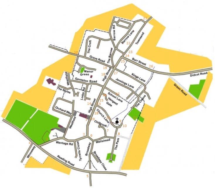
Harwell Village History Trail (About 5 km see map at end with numbered points marked)
|
|
|
- Vernon Webster
- 5 years ago
- Views:
Transcription

1 Harwell Village History Trail (About 5 km see map at end with numbered points marked) 1. Start at Village Hall. Opened as Harwell Technical Institute in Renamed as The Village Hall in December Originally it was divided into two parts. The women of the village were taught cookery and domestic in the room by the kitchen. The men could learn field crafts and carpentry at the western end. Turn right out of the Village Hall car park down the High Street. 2. Continue down and find Rosemead on your right, one of the listed houses in the village. Can you spot the building that was the Chequers Public House on the left as the road changes to Wantage Road? 3. The Jubilee Playground that can be seen from Wantage Road was extended in 2012 and renamed to celebrate the Golden Jubilee of Queen Elizabeth II. 4. Turn right at the end of Wantage Road and cross over Reading Road carefully. A few metres down the road is a lane called Winnaway which used to be called Winnow Way (early 20 th century) - winnowing means removing the chaff. It has the nickname Burma Road, probably because it lead to the Harwell aerodrome. Road names do get changed over time. Reading Road was originally Turnpike Road and there is a Turnpike Cottage further down Reading Road on the right. 5. Turn around and retrace your steps to Wantage Road. Then continue past the turning until you reach the next but one lane on the right. What do you think the old name for this road was? Hollow Way. Holloway (and Winnaway) leads to the Icknield Way (an ancient right of way - Iron Age or earlier, that stretches from Norfolk to Wiltshire) - it takes about 15 minutes to walk there. Copies of the Saxon charters made in 12th and 13th centuries mention the Icknield Way passing by Harwell. Climb even further out of the village and you cross another ancient road - The Ridgeway, that runs more or less parallel to the Icknield Way here. 6. Cross over Reading Road and walk down one of the two marked footpaths which both lead to Broadway. Walk down Broadway. The end of Broadway is the former site of the old village fire engine shed. Turn left at the end. Just before you reach Wantage Road again, you will see an old letter box on the right hand side. Can you spot the letters VR? These stand for Victoria Regina, i.e. Queen Victoria. This was the first post box in Harwell. Postage stamps were first issued in Great Britain in 1840 in the early days of Queen Victoria's reign. Read the plaque to find out when the pillar box became part of the seat. 7. Retrace your steps back past Broadway along Wellshead. Wellshead House (formerly The Poplars) was the home and surgery of Dr Rice, who either rode his horse or was driven to see


2 patients. After he retired it continued to be the surgery run by Dr Beisley and Dr Cruilshank. Eventually the surgery closed and moved to Mereland Road, Didcot. On the right hand side of the road is Holywell Cottage a wonderful example of a cruck house a technique making use of curved posts. The next road on the left hand side is called Chilbrook. Walk about 20 metres into the road and look over the fence at the pond which is the source of Chilbrook, the stream, which runs northwards through the village and eventually empties into the Thames. 8. Walk down to the end of Wellshead and turn left down The Park. Almost immediately there is a lane on the right hand side with a thatched cob wall (listed) along the far side (probably 18th century). The thatch is for protection. 9. Continue along The Park to St. Matthew's Church, built in its present form between 1190 and At first the church was dedicated to Our Lady. A chapel is mentioned in the Doomsday Survey. If open visit the church to see the two tapestries which the women of the village created to celebrate the village millennium in The so-called Harewell window was restored and additional stained glass added in 1981 by the descendants of John de Harewell ( ) who now live in the USA. 10. Walk past the church and look at Princes Manor on the right - one of the original 3 medieval manors which owned much of the land in the village. The manor (territory) was originally granted by William the Conqueror to Robert d'oily.

 with the graves of men from Australia, New Zealand and Canada as well as the UK, who were based at Harwell aerodrome. 12.")
3 11. Continue round along the footpath to the churchyard (taking the right fork and not the road to the Rectory). On the right hand side across a small paddock the barn has a lovely shepherd weather vane on top of the wavy roof! Continue past the paddock and go through the gate on the right and walk to the low-hedged enclosure. There are a number of commonwealth war graves here (World War 2) with the graves of men from Australia, New Zealand and Canada as well as the UK, who were based at Harwell aerodrome. 12. Retrace your steps back past the church and turn right down Church Lane. Walk along to the thatched cottage (Dell Cottage) on the left - another wonderful example of a cruck house. Note the thatched bird - a symbol to show which person thatched the roof. 13. Walk to the end of Church Lane. The corner on the right was the site of the Boot Public House. On the opposite side of the High Street is the building with steps up to the front entrance that was The Crown Public house. During the great fire in 1852 the building was saved by a Mr Walters who apparently spent several hours dousing burning embers as they alighted on the then thatched roof. The sale by auction of the cherry crops (while they were still on the trees) took place there annually. 14. On the High Street the house immediately opposite called Lime Tree House used to provide accommodation for the Bishop of Winchester or members of his household when they travelled in the area. We will see the farmhouse now called Bishop's Manor Farm later in the trail. 15. Walk right along the High Street past the Almshouses on the right. Frances Geering (nee Jennings) bequeathed in her will (1723) a sum of money for the purchase of a house or ground for the building of Almshouses for six poor widows to live in. In front of the Almshouses is the village war memorial to the men of the village killed in both the first and second world wars.


4 16. The next road on the right is called Hengest Gate. This was mentioned in the Saxon Charter of 985 describing the Anglo-Saxon bounds of Harwell: 'Starting from Harundun Way, it goes to the people of Middleham, to Sutton lake; from Sutton lake to the people of Leofsige, to the twisted ditch; from the twisted ditch to the bramble-thorn; from the bramble-thorn to Hengest Gate in the old down, to the people of Brihtwold; from the people of Brihtwold then to Harandun.' The modern boundaries of Harwell are very similar. 17. Continue along the High Street to School Lane on the right. This does not lead to the Primary School in the village now, but instead to the old school built in 1894 as the Parish/Council School (closed in 1962). The current school is located in The Styles reached from Gaveston Road opposite School Lane. Gaveston Road was named after Piers Gaveston, a favourite of Edward II, who was awarded the manors in Harwell. Walk down School Lane to the old school on the left at the end before the road narrows into a footpath. The old School House (17th century) is on the opposite side of the road. Look at the plaque. 18. Continue down the footpath and round to the left to the junction of The Cleave (used to be The Clive) and Jennings Lane. Walk down Jennings Lane back to the High Street. On the opposite side of the road is the Bargain Stone. It was formerly located at Junction of The High Street and Kings Lane. Cross the road (using the pedestrian crossing) and try to shake hands through the hole in the stone to seal a bargain! A horse-fair is traditionally supposed to have been held in Harwell in medieval times. The bargain stone is said to have been used at these horse-fairs for paying the money. The bargain stone is a sarsen stone. 19. Continue along the High Street and before Grove Road look left to see Middle Farm (renamed King's Manor and now Bailols Manor) which was occupied from about 1200 to 1350 by the Bayllols family and by the Brounzs from about 1350 to In the 13th century the Bayllols were the most important residents in Harwell. 20. Walk down Grove Road (careful as there is no footpath here) to see another thatched cob wall (also listed) running along the left hand side. Continue past The Croft on the right hand side and then take the footpath on the right. These fields all contained cherry orchards that Harwell was


5 famous for. They were replaced by apple trees when disease struck. The apple trees were then removed after entering an EU agreement - farmers were paid to remove them. John Masefield wrote a poem called The Cherries which describes cherry production in Harwell. Two short excerpts: Below, where the springs burst and the brooks trill, Long centuries since, man found that cherries throve For Harwell Man's perpetual treasure-trove. When every bird is as a little boy, A winged imp, to threaten and annoy, To peck the ripening cherries, and to thieve The sweet-fleshed fruit from dewy dawn to eve. 21. The footpath bends through 90 degrees 3 times (right and left alternating) and eventually emerges onto Barrow Road. Turn left and take the footpath on the right after the next turning. This footpath brings you out onto Barrow Lane. Turn left and walk down to Townsend. A cherry orchard still thrives on the opposite side of Townsend. 22. Turn right along Townsend and walk down past Pomander House, another cruck house from 16th century, on the right hand side. Notice the unusual brick work. Townsend was the old road to Sutton Courtney. 23. Walk to the corner of the High Street and Burr Street. On the left hand side you pass Bishop's Manor (Farm) - the present house has a 17th century front. It was the Grange of the Bishop of Winchester's manor of about a thousand acres. From 13th to 15th century the manor was known as Lower Manor or Bishop's Harwell. 24. Pollards the house standing on the corner of Townsend and Burr Street tells is listed and was the old Post Office.

6 25. The Hart of Harwell on the opposite corner used to be called The White Hart, another of the six public houses that used to exist in the village. It has an Aunt Sally pitch around the back. Aunt Sally is a traditional game still played throughout Oxfordshire. The dolly is placed on a metal spike about 1 m high and short sticks are thrown to knock it off. The White Hart was originally a bakery but has served as a public house for about 380 years, in former days as a coaching inn. It has an unusual chamber over the entrance door. 26. Walk down Burr Street. The Crispin public house was on the right and further down on the left by the Chilbrook was The Queens Arms later called The Kicking Donkey after a donkey was taken into the bar and caused some damage. 27. Walk back up Burr Street, cross over Townsend and start to walk back along the High Street. Then cross the High Street when opposite Bob's Butchers and the newsagents. The house immediately after the newsagents is Adnam's Farm where the great fire began in Next door is The Old Bakery. 28. Walk back towards the Village Hall. Before the garage on the left after Church Lane is a (listed) milestone - before we had signposts this was how people knew how far it was to the next village or town (probably mid 19th century - listed). This one shows that it is 6 miles to Wantage and 8 miles to Wallingford! 29. Cross the road again to return to the Village Hall.
7
Walk 2 Village Hall - The Shippy - Woodhouse Farm - Village Hall
 Walk 2 Village Hall - The Shippy - Woodhouse Farm - Village Hall The walk is approximately 4km (2.5 miles) across fairly flat countryside with about a quarter on country lanes. It should take about 1 hour
Thornton le Dale Walks
 Thornton le Dale Walks A collection of circular walks in, and around, the village www.visitthorntonledale.co.uk Thornton-le-Dale Traders Forum and Thornton le Dale Parish Council 1 Thornton le Dale Circular
Harlington - Sharpenhoe - Pulloxhill
 Harlington - Sharpenhoe - Pulloxhill ID: 3676, Distance: 8 miles, Height gain: 140 Metres, Map: Explorer 193 Luton & Stevenage, Contributor: Dennis Jeanes Duration: 3 Hours 27 Mins Features Church,Great
Walks Around Bishopstone & Hinton Parva
 The Walks: From ½ mile ambles to 8 mile scenic loops Hinton Parva Walks H1 H2 H3 Bishopstone Walks B1 B2 B3 B4 B5 Walk B1: Bishopstone Village, The Dingle (stream) & Pond A short circular village amble
Husthwaite to Byland Abbey
 Husthwaite to Byland Abbey This walk begins with a loop round the village of Husthwaite and continues towards Coxwold along a disused railway line, which is now a right of way. It passes through Coxwold
Welsh Newton and Woodland
 Welsh Newton and Woodland This is a 8.2km miles (approx) walk which will take about 2.5 hours at a relaxed and leisurely pace. There are a few hills but no steep inclines. Start at Llangrove bus stop and
Thornton le Dale Walks
 Thornton le Dale Walks A collection of walks in and around the village Thornton le Dale Traders Forum www.visitthorntonledale.co.uk Thornton le Dale Walks Walk 1: Beck Isle Cottage and All Saints Church
Bonnie Prince Charlie Walk
 Bonnie Prince Charlie Walk A waymarked route from Ashbourne to Derby to celebrate the 60th anniversary (1995) of the formation of the Ramblers' Association. This route follows the general direction of
The Mendip Way. Route Directions and Maps Wells to Frome
 The Mendip Way Route Directions and Maps Wells to Frome Website: www.mendiphillsaonb.org.uk Email: mendip@mendiphillsaonb.org.uk Facebook & Twitter: @MendipHillsAONB Phone: 01761462338 1 Wells to Shepton
The Hundred Parishes
 The Hundred Parishes Walks from railway stations number 9 6.4 miles (10kms) from Bishop s Stortford to Stansted Mountfitchet Start: Bishop s Stortford station (Grid Reference TL492209) (ample parking and
Dyrham and Hinton Parish Walks
 Dyrham and Hinton Parish Walks A series of five walks in the parish, exploring most of the public footpaths. By John Miller Each walk is described in detail, with a complete map, to provide a handy guide
Oldbury & Littleton, South Gloucestershire
 Oldbury & Littleton, South Gloucestershire Starts at Church Lane, Oldbury. BS35 1QF 2 hours 0 minutes 5.2miles 8.4km Easy ID: 0.2468 Developed by: GEOFF MULLETT Checked by: Marion Stone www.ramblersroutes.org
HARDMOORS 26.2 WHITE HORSE HALF ROUTE DESCRIPTION - 018
 HARDMOORS 26.2 WHITE HORSE HALF ROUTE DESCRIPTION - 018 Follow Cleveland Way, keeping to the left hand path (right path is a bike trail) Ignoring any turnings to the left or right At path junction (after
Walk 2: Beamsley Beacon and Bolton Abbey
 Walk 2: Beamsley Beacon and Bolton Abbey Start and Finish: The Memorial Hall, Main Street, Addingham, LS29 0LZ, SE 079 497 The shortest walk is about 5½ miles (8.8km) The medium Walk is about 8¼ miles
Slindon Folly - South Downs, West Sussex
 Slindon Folly - South Downs, West Sussex Starts at Park road-side near entrance to Slindon College 2 hours 15 minutes 4.5miles 7.2km Easy ID: 0.1598 Developed by: Chris Mumford Checked by: Rockpit www.ramblersroutes.org
Walk 7: Watchet to washford
 Walk 7: Watchet to washford Length: Moderate - 7.5 miles / 12 km Good For: Theme: History Duration: 2-3 hours depending on speed of walking Notes: This is a moderate to difficult walk in places, with steps,
There are toilets at Manningtree Station, Flatford (close to the hump back bridge) and in Dedham.
 and in Dedham.") Arriving by Train Main Features of the Walk Outline Route Employs particularly attractive paths, many of which offer impressive views across Dedham Vale. Includes a section along the tidal section of the
Arriving by Train Main Features of the Walk Outline Route Employs particularly attractive paths, many of which offer impressive views across Dedham Vale. Includes a section along the tidal section of the
How to get there. Respect - Protect - Enjoy
 How to get there Driving: Postcode is OX10 6AD with a car park for customers. Nearest station: Goring & Streatley station is 5.6 miles away. We re delighted to present three circular walks all starting
Footpaths and walks in the Leckhampton Fields
 APPENDIX 5 Footpaths and walks in the Leckhampton Fields Because of its network of footpaths, the Leckhampton Fields have many different walks. The rich diversity of landscape, hedgerows, trees, streams,
Danbury Words and pictures by Laurie Page of the Public Rights of Way team at Essex County Council.
 Danbury Words and pictures by Laurie Page of the Public Rights of Way team at Essex County Council. An undulating walk from Danbury village to the bluebells at the National Trust property of Blakes Wood.
Redesdale Arms. A Trio of Walks
 Redesdale Arms A Trio of Walks Welcome to The Redesdale Arms Hotel The award winning 34 bedroom Redesdale Arms Hotel sits at the gateway to the Cotswolds in the High Street of the historic town of Moreton-in-Marsh.
Approximate distance: 10 miles For this walk we ve included OS grid references should you wish to use them. Start. End
 Approximate distance: 10 miles For this walk we ve included OS grid references should you wish to use them. 2 3 Start End 1 N W E S Reproduced by permission of Ordnance Survey on behalf of HMSO. Crown
TOCKENHAM. Walks for Healthy Living. The Countryside Code (October 2016) Respect other people:
 Respect other people:") The Countryside Code (October 2016) TOCKENHAM Respect other people: consider the local community and other people enjoying the outdoors leave gates and property as you find them and follow paths unless
The Countryside Code (October 2016) TOCKENHAM Respect other people: consider the local community and other people enjoying the outdoors leave gates and property as you find them and follow paths unless
Lincolnshire Walks. Grainthorpe. Three circular walks of 2 ¾, 9 and 9 ½ km (1 ¾, 5 ½ and 6 miles)
") Lincolnshire Walks Grainthorpe Three circular walks of ¾, 9 and 9 ½ km (1 ¾, ½ and 6 miles) Introduction Explore the coastal marshes, arable hinterland, Louth Navigation canal and the village of Grainthorpe
Lincolnshire Walks Grainthorpe Three circular walks of ¾, 9 and 9 ½ km (1 ¾, ½ and 6 miles) Introduction Explore the coastal marshes, arable hinterland, Louth Navigation canal and the village of Grainthorpe
Route: Skewsby Foulrice Stearsby
 Route: Skewsby Foulrice Stearsby Distance: 7 miles Map: Explorer: 300 Howardian Hills & Malton Start (OS ref): SE625710 Park in the village of Skewsby. Walk east out of the village to the T-Junction and
Beautiful Walks from the Blue Ball Inn
 Walk No. 7 COAST AND VALLEY WALK Countisbury, Glenthorne, County Gate, Brendon, Rockford and Wilsham 10 MILES APPROX. Walking time 5 hours approx. (not including breaks)> OS Sheet 64/74 Lynton and Lynmouth.
Bakewell Club Site - Robin Hood's Stride
 Bakewell Club Site - Robin Hood's Stride Camping and Caravanning Route Summary A circular walk with fabulous views winding it's way through the beautiful White Peak scenery. Points of interest include
Approximate distance: 5.5 miles For this walk we ve included OS grid references should you wish to use them. Start. End
 Approximate distance: 5.5 miles For this walk we ve included OS grid references should you wish to use them. End 4 1 Start 3 2 N W E S Reproduced by permission of Ordnance Survey on behalf of HMSO. Crown
ANSWERS. A Who had their office as 22 High Street, Flitwick? National Allotments and Gardens Society Ltd
 BURLEY IN WHARFEDALE FESTIVAL TREASURE HUNT 2016 NAME AND TELEPHONE NUMBER ANSWERS The Treasure Hunt starts and finishes at the Round House. You can do the hunt at any time during Festival Week whenever
Walk Description. Directions
 Title: Saffron Trail: Battlesbridge to Chelmsford Distance: 14¾ miles Time taken: 6 hours Start Point: Outside the Barge Inn, Battlesbridge OS Explorer Map: 175 & 183 Grid Ref.: TQ 780 947 Transport: Rail:-
H&T. H O L L O W E L L & T E E T O N P A R I S H C O U N C I L
 H&T. H O L L O W E L L & T E E T O N P A R I S H C O U N C I L Web site: http://www.hollowellandteeton.org.uk/ Email: pc-clerk@hollowellandteeton.org.uk Re: Hollowell & Teeton Parish Council Mowing Areas
Banstead: Village and Woods
 point your feet on a new path : Village and s Distance: 10 km=6 miles Region: Surrey Author: Fusszweig Refreshments:, The Ramblers Rest easy walking Date written: 2-apr-2014 Last update: 11-apr-2017 Map:
SUMMER WALK 10. The Chairmakers, Worlds End
 SUMMER WALK 10 The Chairmakers, Worlds End Tuesday 10 th June 7.30pm This is a very short walk made so due to the majority of the footpaths in the area around the Chairmakers being overrun with high nettles
9.5 km Circular 3 hours
 MEDIEVAL WAVERLEY Challenging Terrain A 6 mile (9.5km) undulating circular walk from Tilford village passing close to The Sands village and the historic ruins of Waverley Abbey. From the top of Crooksbury
This walk description is from happyhiker.co.uk
 This walk description is from happyhiker.co.uk Pendle Hill Walk From Barley Starting point and OS Grid reference Ordnance Survey map Distance Traffic light rating Barley village honesty box car park OS
Hammer Vale and Linchmere Common
 point your feet on a new path Hammer Vale and Linchmere Common Distance: 9 km=5½ miles or 6 km=3¾ miles easy walking with one steep section Region: Hampshire, West Sussex Author: Botafuego Refreshments:
Launton to Bicester nature footpath improved
 Launton to Bicester nature footpath improved Published 13 July 2012 An attractive rural footpath linking Launton to Bicester has brought back into use by the council's Countryside team. Staff have improved
Brightwalton, Chaddleworth, Leckhampstead, Peasemore: Four Downland Villages
 point your feet on a new path Brightwalton, Chaddleworth, Leckhampstead, Peasemore: Four Downland Villages Distance: 13 km=8 miles Region: Berkshire Author: MacMeadow Refreshments: Peasemore, Leckhampstead
LDWA SOUTH DOWNS MARATHON
 AHD ahead SDW South Downs Way BL/BR bear left/bear right TL/TR turn left/turn right SP signpost/fingerpost X cross LEG 1 - EAST DEAN to WP1 NORTON GR 470019. Open 1030 to 1300. 9.6 miles. 1.1 From village
Hexham Abbey to the Racecourse Road
 Hexham Abbey to the Racecourse Road The Yarridge Road, or Racecourse Road as it is often known, runs along the ridge line to the south of Hexham and provides wonderful views of the river valley and fells
Maps The maps provided are a guide and are not to scale. Please use OS Explorer Map 120 (Chichester).
.") A Walker s Guide - Chichester Harbour Useful Information Directions All the walks were tested in 2013. Please note, however, that some footpaths may be diverted and buildings such as pubs may have changed
A Walker s Guide - Chichester Harbour Useful Information Directions All the walks were tested in 2013. Please note, however, that some footpaths may be diverted and buildings such as pubs may have changed
Fertile farms in the heart of Kent
 55 55 Fertile farms in the heart of Kent A bright sunny day is perfect for enjoying the rich and fertile Kent countryside and outstanding views across the valley of the Great Stour to the North Downs.
Follow the Lantern Way clockwise from Dursley Town Hall through Cam & Coaley to Uley and back to Dursley (about 14 miles)
") According to the Rev Kilvert's diary of 1873, couples on their way to evening services in winter followed a practical though unusual local tradition: "My Mother says that at Dursley, when ladies and gentlemen
According to the Rev Kilvert's diary of 1873, couples on their way to evening services in winter followed a practical though unusual local tradition: "My Mother says that at Dursley, when ladies and gentlemen
How to get there. Respect - Protect - Enjoy
 How to get there Driving: Postcode is RG9 5PF and there is a car park just across from the pub. Nearest station: Henley-on-Thames station is 5.6 miles away. We re delighted to present three circular walks
For Your Own Safety. Please make a note below of the contact number that should be used in the event that you get lost or require other assistance
 Respect Protect Enjoy Respect other people Consider the local community and other people enjoying the outdoors Leave gates and property as you find them and follow paths unless wider access is available
THE WELLDIGGERS ARMS, HESWORTH AND FITTLEWORTH TRAIL
 THE WELLDIGGERS ARMS, HESWORTH AND FITTLEWORTH TRAIL 5.5 miles Circular 3 hours 041017 Challenging Terrain A 300-year-old pub turned country-inn on the edge of the South Downs National Park, The Welldiggers
Saltash, Cornwall - Railways, Rivers & Castles
 Saltash, Cornwall - Railways, Rivers & Castles Starts at St Stephen's Church, Saltash, Cornwall 2 hours 45 minutes 5.5miles 8.9km Easy ID: 0.2532 Developed by: Peter Clements Checked by: Kevin Connor www.ramblersroutes.org
NEWLANDS CORNER AND ST MARTHAS
 NEWLANDS CORNER AND ST MARTHAS 10k CIRCULAR ROUTE 2½-3HRS GU4 8SE From Newlands Corner on the North Downs just outside Guildford, you can enjoy one of the most beautiful panoramas of quintessential English
A Walk around Holmes Chapel starting & finishing at Holmes Chapel Railway Station. by Tony & Lindsay Wright (2016)
") A Walk around Holmes Chapel starting & finishing at Holmes Chapel Railway Station. by Tony & Lindsay Wright (2016) Introduction Holmes Chapel Railway Station is on the Crewe to Manchester line. The station
A Walk around Holmes Chapel starting & finishing at Holmes Chapel Railway Station. by Tony & Lindsay Wright (2016) Introduction Holmes Chapel Railway Station is on the Crewe to Manchester line. The station
holly tree Wellhill Farm Woodyard Bramham House red kites Round House ha-ha
 This 6.4 mile walk around the magnificent Bramham Park Estate has been made possible with the active support of the owner of the Estate, Nick Lane Fox, with funding from Natural England, as part of Defra
NETTLESTEAD & YALDING
 NETTLESTEAD & YALDING ULL CIRCUIT - Sheet 1 (first and last sections) Open fields (see 'Introductory Notes') 88 Direction label (as in the walk notes) ROADS: 81 10m Significant roads Redhill arm North
LOCAL CIRCUIT EM1: EAST MALLING & BARMING HEATH. N 2m ROADS: Significant roads PATHS: Starting direction Barming Longsole Mission Church
 Ditton Church Scott Close LOCAL CIRCUIT EM1: EAST MALLING & BARMING HEATH 6 Community Centre F Open fields (see 'Introductory Notes') 1m 88 Direction label (as in the walk notes) East Malling Church -
How to get there. Respect - Protect - Enjoy
 How to get there Driving: Postcode is RG9 6QU and there is a car park for customers. Nearest station: Marlow train station is 7.8 miles away. We re delighted to present three circular walks all starting
Ovington and Itchen Stoke
 Trail Activity Type Terrain Author Distance Ascent Location : HAMPTR0057 : Walk : Pub : Towpaths and Cycle Tracks : Peter Carne : 1.4 miles / 2.2 kms : 62 feet / 19 metres : SU560318 / SO24 0RE Bush Inn,
Thirsk Castle. To begin the walk go to the west of
 Past and Present is a walk around Thirsk and Sowerby to enjoy the town and countryside, but also to learn about local history. It takes in sites of historical and environmental approximately three miles
No. 1 By River Ribble & Brungerley Park 3¼ Miles,
 RVRNEWS 102 No. 1 By River Ribble & Brungerley Park 3¼ Miles, Approx 2 Hours This walk starts at the gate on platform 2 of Clitheroe station. Leaving the station turn left making towards Kirkmoor Rd and
ETON DRAFT Jim Walker The Outdoor Trust
 Jim Walker The Outdoor Trust Eton Walkway (2 miles = 3.5km) 01 Kings Stables 02 The Cockpit 03 Eton Porny School 04 Baldwins Bridge 05 Eton College and Chapel 06 The Timbrall s and Eton Wall Game 07 Gormley
The North Pennines from near Langwathby
 3.6 Langwathby to Armathwaite Map panel?? Distance 12.7 miles (20.5 km) Terrain farm, woodland and riverside paths; some potentially muddy tracks; a few short sections of road Grade gently undulating Food
Winterfold Wood. point your feet on a new path. In Brief
 point your feet on a new path Winterfold Wood Distance: 8½ km=5¼ miles Region: Surrey Author: Schwebefuss Refreshments: Windmill Inn, Peaslake after the walk moderate walking with many gradients Date written:
Masson Hill. Walk. Approximately 4 km. Moderate Walk Begins from Matlock Railway Station
 Masson Hill Walk Approximately 4 km Moderate Walk Begins from Matlock Railway Station TOWN WALKS Masson Hill walk is approx. 4 km. It can be walked in a couple of hours or so. Enjoy your walk and the beautiful
Walk 2: doniford to east quantoxhead
 Walk 2: doniford to east quantoxhead Length: 9 ¼ miles / 15km Good For: Difficulty: Moderate Theme: Nature Notes: This walk is tidal - please check tide times before setting off. Dogs are welcome but need
Lincolnshire Limewoods Walks. Woodhall Spa. A circular walk of 13km (8 miles)
") Lincolnshire Limewoods Walks Woodhall Spa A circular walk of 13km (8 miles) Introduction The Lincolnshire Limewoods is an area between Wragby, Bardney and Woodhall Spa. It is a fantastic place to explore
Lincolnshire Limewoods Walks Woodhall Spa A circular walk of 13km (8 miles) Introduction The Lincolnshire Limewoods is an area between Wragby, Bardney and Woodhall Spa. It is a fantastic place to explore
Although the majority of these walks are around country lanes you should still follow the Country Code:-
 With the update of the Parish Plan was a request for details of any Walks around Pillaton The following pages give several walks that I and my wife have done for many years. Please be aware that NONE OF
Uif!Sfe!Mjpn-!Mpnhepn! bne!dbnnpdl!dibtf-! Tubggpsetijsf
 Uif!Sfe!Mjpn-!Mpnhepn! bne!dbnnpdl!dibtf-! Tubggpsetijsf 7/6!njmft! Djsdvmbs!!!!!!! 4!up!4/6! ipvst Strenuous Terrain Uif!Sfe!Mjpn!jt!b!dmbttjd!wjmmbhf!qvc-!b! hsfbu!qmbdf!up!tbujtgz!zpvs!ivnhfs!bgufs!b!
How to get there. Respect - Protect - Enjoy
 How to get there Driving: Postcode is OX49 5HL with a car park for customers Nearest station: Henley on Thames station is 9.5 miles away. We re delighted to present three circular walks all starting and
LDWA SOUTH DOWNS MARATHON 13 th MAY 2018
 AHD ahead SDW South Downs Way BL/BR bear left/bear right TL/TR turn left/turn right X cross LEG 1 - EAST DEAN to WP1 NORTON GR 470019. Open 1030 to 1300. 9.7 miles. 1.1 From village hall TL and walk to
THE DOG AND DUCK HAREWOODS ESTATE TRAIL. 6 Miles Circular 3 hours. Getting there. Walk Sections
 THE DOG AND DUCK HAREWOODS ESTATE TRAIL Moderate Terrain A 6 mile circular pub walk from the Dog and Duck in Outwood, Surrey. The Dog and Duck is a delightful pub where everyone is made welcome. From walkers
10 Miles Circular 5 hours
 VISIT RYEDALE PICKERING AND CAWTHORN CAMPS 10 Miles Circular 5 hours Moderate Terrain 120616 A 10 mile (16km) there and back walk from the market town of Pickering in Ryedale. The route heads north through
THE PONTON PLOD - 27 MILE ROUTE
 THE PONTON PLOD - 27 MILE ROUTE Emergency Phone Number 07771 813514 Abbreviations: BW Bridleway X Cross immd immediately FP Footpath TL Turn left L Left thro through KG Kissing Gate TR Turn right R Right
Sutton Valence or Harrietsham to Pluckley
 Sutton Valence start last checked Harrietsham start last checked Rest of walk last checked 22 April 2018 30 March 2017 3 June 2017 Document last updated: 2 May 2018 This document and information herein
6 Miles Linear 3 hours
 SPIRES AND STEEPLES Part 2: BRANSTON TO METHERINGHAM 6 Miles Linear 3 hours 160818 Moderate Terrain A 6 mile (10km) linear walk from Branston to Metheringham, forming the second part of the Spires and
Distance: 14 km=8½ miles or 7 km=4½ miles easy-to-moderate walking
 point your feet on a new path Normandy Distance: 14 km=8½ miles or 7 km=4½ miles easy-to-moderate walking Region: Surrey Author: Botafuego Refreshments: Pirbright, Ash date written: 20-feb-2012 date revised:
Pluckley Circular. The Low Weald of Kent and The Darling Buds of May. Features. Walk options. Transport
 Main walk last checked Extension last checked 25 April 2017 25 April 2017 Current status Document last updated: 12 May 2017 This document and information herein are copyrighted to Saturday Walkers Club.
Green Man Ultra Route Directions 2018
 Green Man Ultra Route Directions 2018 Start-CP1 (9 miles) Community Forest Path (CFP) Frome Valley Way (FVW) From the starting line cross the playing fields diagonally to the metal gates in the hedge lined
Bledlow Beechwoods and Bledda s Rest
 point your feet on a new path Beechwoods and Bledda s Rest Distance: 16 km=10 miles Region: Chilterns Author: Phegophilos Refreshments:, Bennett End moderate walking Date written: 2-sep-2010 Last update:
Slaugham, Bolney, Warninglid
 point your feet on a new path Slaugham, Bolney, Warninglid Distance: 14 km=8¾ miles or 2 walks of 6 km=3¾ miles and 9 km=5¾ miles easy walking Region: West Sussex Author: Moussehaine Refreshments: Bolney,
DOLTON & DOWLAND WALKS
 DOLTON & DOWLAND WALKS Take the paths less trod Welcome to this selection of walks in and around the neighbouring parishes of Dolton and Dowland, also straying into the adjacent parishes of Beaford, Merton,
A circular walk of or km (2 1 4 or miles)
") Grantham A circular walk of 3 3 4 or 5 3 4 km (2 1 4 or 3 1 2 miles) Introduction This relatively short circular walk, which starts in the middle of Grantham, offers plenty of variety. The route takes
Grantham A circular walk of 3 3 4 or 5 3 4 km (2 1 4 or 3 1 2 miles) Introduction This relatively short circular walk, which starts in the middle of Grantham, offers plenty of variety. The route takes
Tiny Treks Alderley Edge
 Tiny Treks Alderley Edge Start: Alderley Edge, National Trust Car Park, B5087 Macclesfield Road Alderley Edge. SK10 4UB. Facilities: WC, Parking (Pay and Display), Visitors centre, Café Walk: Approx 2miles
Maps The maps provided are a guide and are not to scale. Please use OS Explorer Map 120 (Chichester).
.") A Walker s Guide - Chichester Harbour Useful Information Directions All the walks were tested in 201. Please note, however, that some footpaths may be diverted and buildings such as pubs may have changed
A Walker s Guide - Chichester Harbour Useful Information Directions All the walks were tested in 201. Please note, however, that some footpaths may be diverted and buildings such as pubs may have changed
Key Information. Self-Guided Walk Exploring Sedbergh
 Self-Guided Walk Exploring Sedbergh A great short walk - ideal for an early evening in summer. This is a lovely circuit of Sedbergh visiting some of the historic buildings as well as ambling by the river
Walk 3 - Woodbridge and Melton A Walk Round Waldringfield by Sue and Jim Stacey. Woodbridge. shopping centre, cafes, toilets etc. tide mill.
 Walk 3 - Woodbridge and Melton A Walk Round Waldringfield by Sue and Jim Stacey. road with roundabout church railway with station walk route showing description direction track, wide path, bridlepath footpath
How to get there. Respect - Protect - Enjoy
 How to get there Driving: Postcode is RG9 3DG and there is a carpark just across from the pub. Nearest station: Henley-on-Thames station is 5.6 miles away. We re delighted to present three circular walks
Shepherdswell - Dover
 Shepherdswell - Dover The North Downs Way > Shepherdswell to Dover Introduction This part of the path is slightly different in character from most other parts of the path since it spends much of the time
Learning to Look at Architecture. Slide Introduction to West Chester Walking Tour
 Learning to Look at Architecture Slide Introduction to West Chester Walking Tour Title Slide. People come to museums like the Chester County Historical Society to learn about the past from objects and
Fingest, Christmas Common, Pishill, Turville Red Kites and Red Deer
 point your feet on a new path Fingest, Christmas Common, Pishill, Turville Red Kites and Red Deer Distance: 23 km=14 miles Region: Chilterns Author: Bryntafion Refreshments: every village! Map: Explorer
RANS WOOD WALK circa 3 miles/ 5 kilometres
 RANS WOOD EXCURSION This walk is about an hour. It is rarely frequented by tourists or by visitors to the National Park. It is a secret favourite amongst local dog walkers and cyclists. The walk is in
ST. AGNES. you cannot put a time limit on beauty.
 ST. AGNES CIRCULAR WALKS AROUND There are many enjoyable and picturesque walks around St. Agnes most are signposted and are featured on the St. Agnes Mini-guide map. Because most of our footpaths are in
Stokenchurch. Bluebell Woods, Bomber Memorial, Red Kites, Getty s Cricket Ground, Nature Reserve
 Stokenchurch Bluebell Woods, Bomber Memorial, Red Kites, Getty s Cricket Ground, Nature Reserve Bomber Memorial The best time to visit Cowleaze Wood is in the spring when there is a memorable display of
Meopham Green, Stansted and the Sweet Mile Ridley, Fairseat, Hodsoll Street
 point your feet on a new path Meopham Green, Stansted and the Sweet Mile Ridley, Fairseat, Hodsoll Street Distance: 4½ km=9 miles or 9½ km=6 miles easy-to-moderate walking Region: Kent Author: Malinovka
Angel Drove carpark 3/day
 GETTING TO ELY ( A on the map below marks the city centre; for a larger scale see the map at the end of the directions, where there are also details of car parking and pedestrian access to the venue) Angel
The main feature of this tranquil walk is a visit to the source of the Thames (the Thames head) which is in a field just 3 km from Kemble station
 which is in a field just 3 km from Kemble station") SWC Walk DRAFT Kemble circular: the source of the River Thames. The main feature of this tranquil walk is a visit to the source of the Thames (the Thames head) which is in a field just 3 km from Kemble
SWC Walk DRAFT Kemble circular: the source of the River Thames. The main feature of this tranquil walk is a visit to the source of the Thames (the Thames head) which is in a field just 3 km from Kemble
RILLINGTON TO MALTON by Tania Dickinson
 RILLINGTON TO MALTON by Tania Dickinson This walk takes you from the Vale of Pickering up on to the Wold scarp, before dropping down again through the pretty village of Settrington and joining the Centenary
NORTH BOVEY, DARTMOOR WALKS FROM RING OF BELLS NORTH BOVEY. By Debbie Jenkin
 NORTH BOVEY, DARTMOOR WALKS FROM RING OF BELLS NORTH BOVEY By Debbie Jenkin CONTENTS Page Introduction Walk 1 Ring of Bells - 3/4 of a mile 3 & 4 Walk 2 Ring of Bells - 3.5 miles 5 & 6 Walk 3 Ring of Bells
Hascombe and Winkworth Arboretum Downs Link Path, Smithbrook Kilns
 point your feet on a new path Hascombe and Winkworth Arboretum Downs Link Path, Smithbrook Kilns Distance: 18 km=11 miles Region: Surrey Author: RDC easy walking Date written: 7-may-2016 Last update: 30-aug-2018
BRINKLEY STUD. Dullingham, Newmarket
 BRINKLEY STUD Dullingham, Newmarket BRINKLEY STUD Dullingham, Newmarket Newmarket 4 miles, Cambridge 13 miles, M11 (junction 9) 14 miles, Stansted Airport 32 miles A 133 acre stud farm near Newmarket with
9.5 km Circular 3 hours
 SILENT POOL AND ST MARTHA S HILL Challenging Terrain A 9.5km (6 mile) circular walk in the Surrey Hills, visiting a number of popular attractions including Silent Pool, a stretch of the North Downs Way,
Views! village, woodland, hills, high trails, fine houses, hidden church
 point your feet on a new path Heath Distance: 9½ km=6 miles Region: Chilterns Author: Phegophilos Refreshments: easy walking Date written: 13-oct-2017 Map: Explorer 171 (Chiltern Hills West) but this guide
& r al. Two circular walks of 8 km (5 miles) wal k
 wal k") & Ru r al Two circular walks of 8 km (5 miles) s ford Riv m a t S er wal k Introduction Stamford is noted as being one of the finest stone towns in the country. The stone being local limestone and Collyweston
& Ru r al Two circular walks of 8 km (5 miles) s ford Riv m a t S er wal k Introduction Stamford is noted as being one of the finest stone towns in the country. The stone being local limestone and Collyweston
8 Miles Circular 4 hours
 VISIT RYEDALE HELMSLEY AND RICCAL DALE 8 Miles Circular 4 hours 090616 Challenging Terrain An 8 mile (13km) circular walk from the market town of Helmsley in Ryedale. The route heads out across sheep pastures