APPENDIX A MAPS APPENDIX A: MAPS
|
|
|
- Delphia Green
- 6 years ago
- Views:
Transcription
1 APPENDIX A
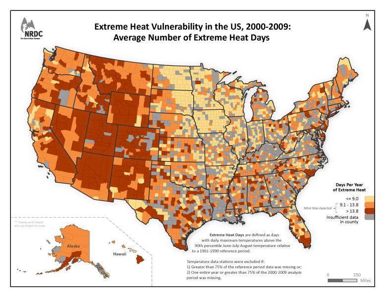
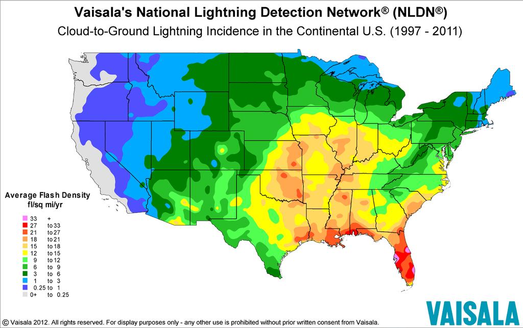
2 APPENDIX A: MAPS APPENDIX A MAPS Appendix A includes maps related to the LMS Plan. Many of these maps are included in the text of the document at a smaller scale. The Appendix includes the following maps: School Locations Extreme Heat Vulnerability in the US, 2-29: Average Number of Extreme Heat Days Hurricane Tracks ( ) Polk Evacuation Routes Florida Building Code Wind Borne Debris Regions Severe Thunderstorm Wind Count Severe Thunderstorms Wind ( ) Severe Thunderstorm Hail Count Severe Thunderstorm Hail ( ) Cloud-to-Ground Lightning Incidence in the Continental US ( ) Tornado Touchdowns Polk County Tornado Tracks by Intensity Sinkholes (October 214) FEMA Flood Insurance Rate Map (FIRM) Polk County S Map Series Repetitive Loss Activity 52 Fire Location Map Since 1981 Wildland-Urban Interface Wildfire Risk (LOC) Wildfire Susceptibility Index Surface Fuels Sections (TRS) Positive for Huanglongbing (HLB, Citrus Greening) in Florida Winter Haven CHRP Area Citrus Greening and Canker as of March 31, 214 Existing and Proposed Pipeline Locations Rail Lines and Crossings Appendix A Page i Polk County Multi-jurisdictional Local Mitigation Strategy Draft: February 215
3 DRAFT «5 «33 98 POLK CITY 27 DAVENPORT LAKE ALFRED HAINES CITY AUBURNDALE WINTER HAVEN LAKE HAMILTON Interstates «9 LAKELAND «57 MULBERRY EAGLE LAKE BARTOW «6 DUNDEE LAKE WALES HIGHLAND PARK Polk Parkway Roads «37 HILLEST HEIGHTS «6 FORT MEADE FROSTPROOF Document Path: D:\Projects\Local Mitigation Strategy\215 LMS\maps\city_limits.mxd
4 DRAFT «5 «33 School Locations 98 POLK CITY 27 DAVENPORT School Locations LAKE ALFRED HAINES CITY AUBURNDALE WINTER HAVEN LAKE HAMILTON Interstates «9 LAKELAND «57 MULBERRY EAGLE LAKE BARTOW «6 DUNDEE LAKE WALES HIGHLAND PARK Polk Parkway Roads «37 HILLEST HEIGHTS «6 FORT MEADE FROSTPROOF Document Path: D:\Projects\Local Mitigation Strategy\215 LMS\maps\school_locations.mxd
5
6 DRAFT Hurricane Tracks ( ) POLK CITY Charley 24 Erin 1995 DAVENPORT Frances 24 LAKE ALFRED HAINES CITY Gabrielle 21 Henri 23 Jeanne 24 AUBURNDALE WINTER HAVEN LAKE HAMILTON Jerry 1995 LAKELAND MULBERRY EAGLE LAKE BARTOW DUNDEE LAKE WALES HIGHLAND PARK HILLEST HEIGHTS FORT MEADE FROSTPROOF Document Path: D:\Projects\Local Mitigation Strategy\215 LMS\maps\Hurricane_Tracks.mxd


7 PI K MM E ML NL A N B A R 15 37B TU 37A C R A 542A Created By: GIS Section Requested By: Standard Map Product Date: Time: 11:51:12 AM Path: S:\Projects\EvacRoute_SurgeZone_Maps\214_Maps\MXDs\EvacRoutes\UTM_Landscape.mxd 44 POLK 64 R Disclaim er: Map is intended for reference only No warranty for accuracy provided C m. N A 5 41 R 5 79 C Evacuation Routes A A POLK PKW Y S R B 57 LL ML LM MM C R A m. E 45 EVACUATION ROUTES FLORIDA DIVISION OF EMERGENCY MANAGEMENT 5
 - Scaled (25%) http:www.")
8 figurea_gray2.png (PNG Image, pixels) - Scaled (25%) 1 of :4 PM
9 11 1 DRAFT Severe Thunderstorm Wind Count Severe Thunderstorm Wind Events Count_ interstates
10 DRAFT «5 «9 98 LAKELAND «57 MULBERRY «37 POLK CITY «33 LAKE ALFRED WINTER HAVEN EAGLE LAKE «6 AUBURNDALE BARTOW FORT MEADE 27 HAINES CITY DAVENPORT LAKE HAMILTON DUNDEE LAKE WALES HIGHLAND PARK HILLEST HEIGHTS Severe Thunderstorms Winds ( ) FROSTPROOF «6 Severe Storm Wind Locations Interstates State Roads Document Path: D:\Projects\Local Mitigation Strategy\215 LMS\maps\severe_tstorms_wind.mxd

11 11 1 DRAFT Severe Thunderstorm Hail Count SevereThunderstormHailCount Count_ interstates
12 DRAFT «5 «33 Severe Thunderstorms Hail ( ) 98 POLK CITY 27 Hail Size (inches) DAVENPORT LAKE ALFRED HAINES CITY AUBURNDALE WINTER HAVEN LAKE HAMILTON Interstates «9 LAKELAND «57 MULBERRY EAGLE LAKE BARTOW «6 DUNDEE LAKE WALES HIGHLAND PARK State Roads «37 HILLEST HEIGHTS «6 FORT MEADE FROSTPROOF Document Path: D:\Projects\Local Mitigation Strategy\215 LMS\maps\severe_tstorm_hail_size.mxd
13
14 DRAFT «5 «33 Tornado Touchdowns «9 98 LAKELAND MULBERRY «37 «57 POLK CITY LAKE ALFRED WINTER HAVEN AUBURNDALE BARTOW EAGLE LAKE FORT MEADE «6 27 HAINES CITY DAVENPORT LAKE HAMILTON DUNDEE LAKE WALES HIGHLAND PARK HILLEST HEIGHTS FROSTPROOF «6 Tornado Touchdowns Interstates State Roads Document Path: D:\Projects\Local Mitigation Strategy\215 LMS\maps\tornado_touchdowns.mxd
15 DRAFT «5 «33 Tornado Tracks by Intensity 98 POLK CITY 27 DAVENPORT Fscale 1 LAKE ALFRED HAINES CITY 2 4 AUBURNDALE WINTER HAVEN LAKE HAMILTON Interstates «9 LAKELAND «57 MULBERRY EAGLE LAKE BARTOW «6 DUNDEE LAKE WALES HIGHLAND PARK State Roads «37 HILLEST HEIGHTS «6 FORT MEADE FROSTPROOF Document Path: D:\Projects\Local Mitigation Strategy\215 LMS\maps\tornado_tracks_intesity.mxd
16 DRAFT «5 «33 Sinkhole Depths ( ) 98 Brian POLK CITY Paul Siddall 27 Don Shade DAVENPORT Sinkhole Depths < 1 feet 1-3 feet Brian LAKE ALFRED HAINES CITY 3-5 feet 5-2 feet AUBURNDALE WINTER HAVEN LAKE HAMILTON Brian Interstates «9 LAKELAND «57 Brian MULBERRY «37 Operator 4529 EAGLE LAKE Patty Metz Patty Metz Patty Metz Patty MetzPatty Metz BARTOW Patty Metz Patty Metz DUNDEE Sharon Hamilton Michele Adamson LAKE WALES «6 HIGHLAND PARK Mickey Harrison HILLEST HEIGHTS «6 State Roads Dan Ryan FORT MEADE Paul Siddall FROSTPROOF Document Path: D:\Projects\Local Mitigation Strategy\215 LMS\maps\sinkhole_Depths.mxd
17 DRAFT FEMA Flood Insurance Rate (FIRM) Map 33 «35 « FP Layer 4 A - Special Flood Hazard AE - Special Flood Hazard AH - Special Flood Hazard X - outside 1 & 5 yr floodplain X5 - inundated by 5 year flooding 57 «39 «37 «information or data furnished hereunder. 6 «6 « Document Path: D:\Projects\Local Mitigation Strategy\215 LMS\maps\floodplain_212.mxd
Each of the Primary PSAPs are under the management of the respective Chief of Police or Sheriff.
 9.53 POLK COUNTY 9.53.1 SYSTEM SUMMARY Polk County s E 9-1-1 system has 2 Primary and 2 Secondary PSAPs as follows: 9.53.1.1 BARTOW POLICE DEPARTMENT SECONDARY PSAP The City of Bartow has a Secondary PSAP
Palm Beach MPO Complete Streets Policy
 Palm Beach MPO Complete Streets Policy Citizens Advisory Committee March 2, 2016 www.palmbeachmpo.org 2300 North Jog Road 4 th Floor West Palm Beach, FL 33411 561-684-4170 What are Complete Streets? Complete
Palm Beach MPO Complete Streets Working Group
 Palm Beach MPO Complete Streets Working Group March 23, 2016 www.palmbeachmpo.org 2300 North Jog Road 4 th Floor West Palm Beach, FL 33411 561 684 4170 Agenda What are Complete Streets? Welcome Complete
CITY ZIP COUNTY ALTAMONTE SPRINGS SEMINOLE ALTAMONTE SPRINGS SEMINOLE ALTAMONTE SPRINGS SEMINOLE ALTAMONTE SPRINGS SEMINOLE
 CITY ZIP COUNTY ALTAMONTE SPRINGS 32715 SEMINOLE ALTAMONTE SPRINGS 32716 SEMINOLE ALTAMONTE SPRINGS 32701 SEMINOLE ALTAMONTE SPRINGS 32714 SEMINOLE ALTOONA 32702 LAKE ALTURAS 33820 POLK ANTHONY 32617 MARION
American Association of State Highway and Transportation Officials
 American Association of State Highway and Transportation Officials An Application from the State Highway or Transportation Department of FLORIDA for the Elimination of a U.S. (I) Route U.S. 98 Alternate
VIRGINIA SOIL AND WATER CONSERVATION BOARD GUIDANCE DOCUMENT ON DAM BREAK INUNDATION ZONE AND INCREMENTAL DAMAGE ANALYSIS AND MAPPING PROCEDURES
 (Approved XXXXX, 2010) Working Draft Version January 14, 2010 VIRGINIA SOIL AND WATER CONSERVATION BOARD GUIDANCE DOCUMENT ON DAM BREAK INUNDATION ZONE AND INCREMENTAL DAMAGE ANALYSIS AND MAPPING PROCEDURES
Polk County Youth Fair 2013 Purebred Beef Show Order January 31, 2013
 2013 Purebred Beef Show Order ZEBU Zebu Females: 45. Katy L. Locke - Bartow Senior FFA (07/15/12) 52. Shelby M. Petersen - Dundee Ridge Middle FFA (04/30/12) 18. Lanson S. Collins - Hoof-N-Horn 4-H (04/25/12)
Minimum Bid: $7, Legal Description: DESCHUTES RIVER RECREATION HOMESITES, INC. UNIT 5; Lot 38; Block 27
 Sale ID: 2015-08 Serial: 115866 Taxlot: 201012C006300 16849 Fontana Rd. Bend, OR 97707 Zoning RR-10, WA Acreage: 0.49 TDC Number: Comments: Vacant platted legal lot. No permit history. Area of high ground
Minimum Bid: $4, Legal Description: DESCHUTES RIVER RECREATION HOMESITES UNIT 6, PART II, Lot 12, Block 79.
 Sale ID: 2016-17 Serial: 126490 Taxlot: 211002B004500 54688 Silver Fox Dr. Bend, OR 97707 Zoning RR-10; LM; WA Acreage: 0.34 Comments: Vacant platted lot (legal lot of record). In area of high groundwater
Baraga County, MI Coastal Hazard Analysis Flood Risk Review Meeting. July 12, 2018
 Baraga County, MI Coastal Hazard Analysis Flood Risk Review Meeting July 12, 2018 Agenda Introductions Coastal Flood Risk Study and Mapping Program Current Status Technical Overview of Study and Mapping
Bay County, MI Coastal Hazard Analysis Flood Risk Review Meeting. May 14, 2018
 Bay County, MI Coastal Hazard Analysis Flood Risk Review Meeting May 14, 2018 Agenda Introductions Coastal Flood Risk Study and Mapping Program Current Status Technical Overview of Study and Mapping Floodplain
We Make a Difference. New Maps, Now What? Updated Coastal Flood Hazard Information for Southern Georgia
 New Maps, Now What? Updated Coastal Flood Hazard Information for Southern Georgia New Maps, Now What? Risk MAP Project Team FEMA Region IV BakerAECOM, FEMA Mapping Partner GA DNR (CTP) NEFL Duval Flagler
2012 PRIORITY TRANSPORTATION PROJECTS
 0 PRIORITY TRANSPORTATION PROJECTS The 0 Priority Transportation Projects include candidate road, congestion management, multi-use trail, transit, transportation regional incentive program (TRIP), county
Citrus, Hernando, and Pasco Coastal Hazard Analysis. Flood Risk Review Meeting Citrus, Hernando, and Pasco Counties, Florida December 14, 2017
 Citrus, Hernando, and Pasco Coastal Hazard Analysis Flood Risk Review Meeting Citrus, Hernando, and Pasco Counties, Florida December 14, 2017 Introductions Risk MAP Project Team FEMA Region IV RAMPP (study
Photo by: Darryl Hatheway, 2011
 Photo by: Darryl Hatheway, 2011 September 11, 2015 Presentation Discussion Examine PFD V-Zone Mapping in Wave Runup Dominated West Coast Application of PFD V-Zone Mapping Criteria in Pacific G&S PFD V-Zone
St. Louis County, MN Coastal Hazard Analysis Flood Risk Review Meeting. May 2, 2018
 St. Louis County, MN Coastal Hazard Analysis Flood Risk Review Meeting May 2, 2018 Agenda Introductions Coastal Flood Risk Study and Mapping Program Current Status Technical Overview of Study and Mapping
Page 1 ofl VIA & US MAIL
 January 8, 20 18 Ms. Melinda Watts Office of Commission Clerk Florida Public Service Commission 2540 Shumard Oak Blvd Tallahassee, Florida 32399-0850 Mwatts@PSC.STA TE.FL.US VIA EMAIL & US MAIL Re: Docket
Bayfield & Ashland Counties, WI Coastal Hazard Analysis Flood Risk Review Meeting. June 05, 2018
 Bayfield & Ashland Counties, WI Coastal Hazard Analysis Flood Risk Review Meeting June 05, 2018 Agenda Introductions Coastal Flood Risk Study and Mapping Program Current Status Technical Overview of Study
0 / FEMA-4337-DR-FL Geospatial Information Unit (GIU)
") INCIDENT MAP BOOK 0 /2018 00 Geospatial Information Unit (GIU) Page Map Title Map Owner 2 Geospatial Library Example Page and Link N/A 3 Map Request Example on WebEOC N/A 4 Links to IA, NFIP, and Branch
INCIDENT MAP BOOK 0 /2018 00 Geospatial Information Unit (GIU) Page Map Title Map Owner 2 Geospatial Library Example Page and Link N/A 3 Map Request Example on WebEOC N/A 4 Links to IA, NFIP, and Branch
Door County, WI Coastal Hazard Analysis Flood Risk Review Meeting. August 21, 2017
 Door County, WI Coastal Hazard Analysis Flood Risk Review Meeting August 21, 2017 Agenda Introductions Coastal Flood Risk Study and Mapping Program Current Status Technical Overview of Study and Mapping
POLK HEALTHCARE PLAN PRIMARY CARE DIRECTORY MARCH 2018
 DOCTOR TODAY TLC, LLC Rekha Issar, MD FLORIDA DEPARTMENT OF HEALTH POLK COUNTY TERRENCE DELIKAT, DO DOCTOR TODAY TLC, LLC Jean F. Balan, MD Rekha Issar, MD Halide Kattan, MD (F) Raysa Mena Perez, MD 101
Using Social Media During an Emergency. Public Information Committee Webinar November 9, 2017
 Using Social Media During an Emergency Public Information Committee Webinar November 9, 2017 Agenda 1200 1205: Intro 1205 1220: FEMA Social Media Online Training 1220 1245: EWEB Winter Storm 2016 1245
FEMA-4337-DR-FL Geospatial Information Unit (GIU)
") INCIDENT MAP BOOK 10/09/201 0 00 Geospatial Information Unit (GIU) Page Map Title Map Owner 2 Geospatial Library Example Page and Link N/A 3 Map Request Example on WebEOC N/A 4 Links to IA, NFIP, and Branch
INCIDENT MAP BOOK 10/09/201 0 00 Geospatial Information Unit (GIU) Page Map Title Map Owner 2 Geospatial Library Example Page and Link N/A 3 Map Request Example on WebEOC N/A 4 Links to IA, NFIP, and Branch
FEMA-4337-DR-FL Geospatial Information Unit (GIU)
") INCIDENT MAP BOOK 11/27/201 0 00 Geospatial Information Unit (GIU) Page Map Title Map Owner 2 Geospatial Library Example Page and Link N/A 3 Map Request Example on WebEOC N/A 4 Links to IA, NFIP, and Branch
INCIDENT MAP BOOK 11/27/201 0 00 Geospatial Information Unit (GIU) Page Map Title Map Owner 2 Geospatial Library Example Page and Link N/A 3 Map Request Example on WebEOC N/A 4 Links to IA, NFIP, and Branch
APPENDIX A. F107 & 380 Lines OYSTER RIVER DURHAM, NH
 APPENDIX A F107 & 380 Lines OYSTER RIVER DURHAM, NH 1. The design and proposed construction of this crossing is shown on the attached PSNH Transmission Business Drawing entitled DOUBLE CKT F107 & 380 BETWEEN
REGIONAL PRIORITIES Presentation to the Tampa Bay Regional Collaboration Committee September 10, 2012
 WEST CENTRAL FLORIDA MPO CHAIRS COORDINATING COMMITTEE REGIONAL PRIORITIES Presentation to the Tampa Bay Regional Collaboration Committee September 10, 2012 TRANSPORTATION REGIONAL INCENTIVE PROGRAM (TRIP)
ORDINANCE NO WHERAS, Goal 105 provides that Lee County will Protect Human Life And Developed Property From Natural Disasters; and,
 ORDINANCE NO. 12-16 AN ORDINANCE AMENDING LEE COUNTY LAND DEVELOPMENT CODE, CHAPTER 6, TO REPLACE EXISTING MAP M-3, WITH FIGURES 169A (ULTIMATE DESIGN WIND SPEEDS RISK CATEGORY II BUILDINGS), 169B (ULTIMATE
COMPLETE STREETS A STEP FORWARD ITE District 10/FSITE Annual Meeting November 3, 2015
 COMPLETE STREETS A STEP FORWARD 2015 ITE District 10/FSITE Annual Meeting November 3, 2015 About Lakeland Incorporated: 1885 Population: 100,728 Area: Approx. 75 sq. mi Major Employers: Publix, Lakeland
Technical Report Culvert A Hydraulic Analysis
 DATE: November 3, 2011 Technical Report Culvert A Hydraulic Analysis TO: FROM: RE: Jim Reiser, P.E. Project Manager Parsons Brinckerhoff, Inc. Kurt Killian, P.E., CFM Parsons Brinckerhoff, Inc. Design
2016 NC Coastal Local Governments Annual Meeting
 2016 NC Coastal Local Governments Annual Meeting Coastal Flood Study Modeling and Mapping 101 April 21, 2016 Tom Langan, PE, CFM Engineering Supervisor NCEM Floodplain Mapping Program FEMA Coastal Flood
FEMA's new flood plain mapping could cost coastal Mainers dearly
 July 5 FEMA's new flood plain mapping could cost coastal Mainers dearly Some communities in York and Cumberland counties hire a consultant to challenge the agency's findings. By Tux Turkeltturkel@mainetoday.com
Building Planning PART. Chapter 3. Chapter 3. Building Planning. Climatic and Geographic Design Criteria C
 PART 2 Building Planning Chapter 3 Chapter 3 Building Planning TA B L E R 3 0 1. 2 ( 1 ) Climatic and Geographic Design Criteria C hapter 3 includes the bulk of the nonstructural provisions, including
Physical Map Revisions in Connecticut due to Updated Coastal Flood Hazards F8: Maps in Transition
 Physical Map Revisions in Connecticut due to Updated Coastal Flood Hazards F8: Maps in Transition Brian Caufield, P.E., CFM Principal Engineer CDM Smith Kerry Bogdan, CFM Senior Engineer FEMA Region I
Ventura County. Open Pacific Coast Study. California Coastal Analysis and Mapping Project
 Ventura County Open Pacific Coast Study California Coastal Analysis and Mapping Project December 2011 Project Name: Meeting: Date and Time: Location: California Coastal Analysis and Mapping Project (CCAMP)/Open
EMERGENCY RESPONSE PLANNING CLASSIFICATION AT SUB- PRECINCT SCALES
 EMERGENCY RESPONSE PLANNING CLASSIFICATION AT SUB- PRECINCT SCALES C Ryan 1, D Tetley 1, P Sheath 2, T Pinelli 3 1 Catchment Simulation Solutions, NSW 2 Wyong Shire Council, NSW 3 State Emergency Service,
Members & Firms
 Members & Firms 2016-2017 PAGE l 43 Members & Firms 2016-2017 PAGE l 44 Members & Firms 2016-2017 PAGE l 45 Members & Firms 2016-2017 PAGE l 46 Members & Firms 2016-2017 PAGE l 47 Members & Firms 2016-2017
SAWS QA/QC CHECKLIST WATER ADJUSTMENT/RELOCATION PROJECTS
 SAWS QA/QC CHECKLIST WATER ADJUSTMENT/RELOCATION PROJECTS Project Name: SAWS Water Job No.: CSJ No. (if applicable): Date: AWS Consultant: PROJECT INFORMATION N/A Yes No Joint Bid (COSA/TxDOT) N/A Yes
Florida Division of Emergency Management State Watch Office
 Florida Division of Emergency Management State Watch Office Morning Situation Report Saturday, October 13, 2018 State Emergency Operations Center Activation Level Level 1 Activation SERT On-Call Personnel
Town of Windham, Vermont Local Hazard Mitigation Plan Adopted 11/2/15, FEMA Final Approved 11/19/15
 Town of Windham, Vermont Local Hazard Mitigation Plan Adopted 11/2/15, FEMA Final Approved 11/19/15 Prepared for the Town of Windham by the Windham Regional Commission Contents I. INTRODUCTION AND PURPOSE...
Weather EOG Review Questions
 Weather EOG Review Questions 1. Which statement best describes runoff? A Water vapor cools off and changes into water droplets. B Water in the form of rain, snow, sleet, or hail falls from clouds. C Precipitation
Life skills polk county florida
 Life skills polk county florida Search Life Skills Center Polk County East Inc in Winter Haven, Florida (FL) Advertisements.. Life Skills Center Polk County East Inc: Employer Identification Number (EIN)
APPENDIX D-2. Sea Level Rise Technical Memo
 APPENDIX D-2 Sea Level Rise Technical Memo 2185 N. California Blvd., Suite 500 Walnut Creek, CA 94596 (925) 944-5411 Fax: (925) 944-4732 www.moffattnichol.com DRAFT MEMORANDUM To: From: Neil Nichols,
Open Pacific Coast Study. California Coastal Analysis and Mapping Project
 Open Pacific Coast Study California Coastal Analysis and Mapping Project September 2012 California Open Coast Counties California Coastal Analysis and Mapping Project This publication is an initiative
Highway 56 Traffic Study Rymal Road to Cemetery Road
 January 31, 2018 6:00 pm 8:00 pm Highway 56 Traffic Study Rymal Road to Cemetery Road City of Hamilton Public Meeting 2 2 Purpose of Public Meeting To review and obtain public input and comments on the
Citrus Producer s Perspective on. Jim Snively
 Citrus Producer s Perspective on Current Citrus Situation in Florida Jim Snively Florida Citrus Acreage 29 Years Florida Citrus Acreage 1,000,000 900,000 941,471 878,019 864,098 845,283 852,369 847,856
Florida Division of Emergency Management State Watch Office
 Florida Division of Emergency Management State Watch Office Morning Situation Report Thursday, October 18, 2018 State Emergency Operations Center Activation Level Level 1 Activation SERT On-Call Personnel
Florida's Crossroads of Opportunity
 Florida's Crossroads of Opportunity Polk County Subject Files The Polk County Historical & Genealogical Library first opened to the public in January 1940 and since that time patrons and library staff
Evaluation of June 9, 2014 Federal Emergency Management Agency Flood Insurance Study for Town of Weymouth, Norfolk, Co, MA
 Evaluation of June 9, 2014 Federal Emergency Management Agency Flood Insurance Study for Town of Weymouth, Norfolk, Co, MA Prepared For: Woodard & Curran 95 Cedar Street, Suite 100 Providence, RI 02903
Emergency Preparedness Developing the Plan
 Hanover Risk Solutions Emergency Preparedness Developing the Plan Having an emergency preparedness plan can directly affect a business s survival from a disaster. This report presents the specific steps
Figure 1 GE image of the Costa Sur & EcoEléctrica power plants, located inside Guayanilla and Tallaboa bay.
 1 7 - STORM SURGES IN PUERTO RICO_Power Plants-Costa Sur & EcoElectrica Costa Sur & EcoEléctrica Figure 1 shows a GE image of the Costa Sur (Guayanilla) and EcoElectrica site. Figure 2 shows the topographic
Florida Division of Emergency Management State Watch Office
 Florida Division of Emergency Management State Watch Office Morning Situation Report Saturday, February 9, 2019 State Emergency Operations Center Activation Level Level 3 Monitoring SERT On-Call Personnel
LANE ELIMINATION PROJECTS
 PRESENTATION OUTLINE Lane Elimination Considerations Districts 4 & 7 Draft Lane Elimination Processes FDOT Lane Elimination Guidelines Example Projects D4 Case Study: SR A1A (Ft. Lauderdale) D7 Case Study:
VIA & US MAlL. January 8, 2018
 January 8, 2018 Ms. Melinda Watts Office of Commission Clerk Florida Public Service Commission 2540 Shumard Oak Blvd Tallahassee, Florida 32399-0850 Mwatts@PSC.ST A TE.FL.US VIA EMAIL & US MAlL Re: Docket
PUBLIC ASSISTANCE MAP BOOK
 PUBLIC ASSISTANCE MAP BOOK 10/19/2018 00 Geospatial Information Unit (GIU) Page Map Title Map Owner 2 PA Categories A & B by County GIU 3 PA Categories C - G by County GIU 4 PA Project Completion by County
MEETING NOTICE POLK TRANSPORTATION PLANNING ORGANIZATION (TPO) BOARD
 BOARD") MEETING NOTICE POLK TRANSPORTATION PLANNING ORGANIZATION (TPO) BOARD DATE: Thursday, February 12, 2015 TIME: LOCATION: 9:00 a.m. Polk County Commission Boardroom Neil Combee Administration Building 330
MEETING NOTICE POLK TRANSPORTATION PLANNING ORGANIZATION (TPO) BOARD DATE: Thursday, February 12, 2015 TIME: LOCATION: 9:00 a.m. Polk County Commission Boardroom Neil Combee Administration Building 330
ANNEX 5 - CITY OF OAKRIDGE. Version 5.0 (March 2018)
") ANNEX 5 - CITY OF OAKRIDGE Version 5.0 (March 2018) Introduction: City of Oakridge This purpose of this annex to the Lane County Multi-Jurisdiction Hazard Mitigation Plan is to consolidate information
ANNEX 5 - CITY OF OAKRIDGE Version 5.0 (March 2018) Introduction: City of Oakridge This purpose of this annex to the Lane County Multi-Jurisdiction Hazard Mitigation Plan is to consolidate information
Brian and David Chapman are a father-and-son professional storm-chasing team with more than 17 years of experience.
 By David & Brian Chapman Brian and David Chapman are a father-and-son professional storm-chasing team with more than 17 years of experience. We caught our first tornado in 2001 near Campbellville, says
Slide 1 - Title Slide
 Slide 1 - Title Slide Page 1 of 74 Slide 3 - Welcome Page 3 of 74 Slide 5 - Learning Objectives Page 5 of 74 Slide 6 - Course Section Introductions Page 6 of 74 Slide 7 - Security Precautions Introduction
MADISON COUNTY, ILLINOIS AND INCORPORATED AREAS
 VOLUME 2 OF 2 MADISON COUNTY, ILLINOIS AND INCORPORATED AREAS * * * COMMUNITY COMMUNITY NAME NUMBER ALHAMBRA, VILLAGE OF 170270 ALTON, CITY OF 170437 BETHALTO, VILLAGE OF 170438 COLLINSVILLE, CITY OF 170439
10.9. Community at Risk: Molalla Rural Fire Protection District #73
 10.9. Community at Risk: Molalla Rural Fire Protection District #73 The Molalla Fire District has been identified as a Community at Risk (CAR) by Oregon Department of Forestry. The District has participated
INDUSTRIAL / OFFICE AREA INVENTORY
 ALL NEW Kankakee County INDUSTRIAL / OFFICE AREA INVENTORY 2005 Technical Study 1B Table of Contents Table of Contents..I Forward...II Introduction.III Industrial Park location Map..IV Industrial & Office
George Washington Memorial Hwy. Jeff Parker, CCIM Senior Vice President
 Major upgrades to the property! George Washington Memorial Hwy York River Crossing CONTACT US: Ned Brooks Senior Vice President +1 757 228 1829 ned.brooks@cbre-norfolk.com Jeff Parker, CCIM Senior Vice
8/29/20098 SAHRA - Watershed Visualization
 Module 3 Narration Southwestern Water Cycle 001.wav 26 sec 002.wav 10 sec 003 wav 17 sec Water on Earth is constantly on the move. Water continually circulates between the surface of Earth and the atmosphere
Troubling Tides Part 1: Rising Seas Activity Sheet
 Troubling Tides Part 1: Rising Seas Activity Sheet Name(s) Read the procedure from beginning to end before starting or writing on the Troubling Tides Datasheet. The procedure includes the following parts:
What Causes Different Weather?
 What Causes Different Weather? Table of Contents What causes weather?...3 What causes it to rain or snow?...4 What causes flooding?...5 What causes hail?...6 What causes the seasons?...7-8 What causes
Canada s vast size creates a diverse range of weather conditions and climatic conditions. Warming trend for last 10 years Wet Spring Dry five summers
 Chapter 4 Weather and Climate Canada s vast size creates a diverse range of weather conditions and climatic conditions. Weather examples: Rainy today Snow tomorrow Fog on Wednesday 23 degree C today High
TRANSPORTATION ELEMENT
 TRANSPORTATION ELEMENT Transportation Element - X Background The Transportation Element is new to the Comprehensive Plan, mandated by the 2007 amendment to the South Carolina Comprehensive Planning Act.
The Storm Surge Hazard 2018 TS-8 Tropical Meteorology 2
 The Storm Surge Hazard 2018 TS-8 Tropical Meteorology 2 Daniel Noah National Weather Service Tampa Bay daniel.noah@noaa.gov Tropical Cyclone Storm Surge Is a large dome of water, often 50 to 100 miles
City of Del Mar Local Coastal Plan (LCP) Amendment for Sea Level Rise and Coastal Flooding
 Amendment for Sea Level Rise and Coastal Flooding") City of Del Mar Local Coastal Plan (LCP) Amendment for Sea Level Rise and Coastal Flooding 6/22/17 Presentation to Sea Level Rise Stakeholder- Technical Advisory Committee (STAC) Nick Garrity, P.E. Lindsey
City of Del Mar Local Coastal Plan (LCP) Amendment for Sea Level Rise and Coastal Flooding 6/22/17 Presentation to Sea Level Rise Stakeholder- Technical Advisory Committee (STAC) Nick Garrity, P.E. Lindsey
First of all, you should know that weather and climate are not the same thing.
 First of all, you should know that weather and climate are not the same thing. WEATHER IS: Short term Limited area Can change rapidly Difficult to predict WEATHER is what s happening outside your window
Emergency Action Plan
 Emergency Action Plan ECY 070-37 (Rev 06/2016) To request ADA accommodation including materials in a format for the visually impaired, call Ecology Water Resources Program at 360-407-6872. Persons with
NSW STATE STORM EMERGENCY SUB PLAN EMERGENCY PLANNING IN THE COASTAL ZONE
 NSW STATE STORM EMERGENCY SUB PLAN EMERGENCY PLANNING IN THE COASTAL ZONE November 2013 Cherie Parmenter 1, Nicholas Kuster 1, Belinda Davies 1 Phil Watson 2 1 NSW State Emergency Service (NSW SES) 2 NSW
Weather & Atmosphere Study Guide
 Weather & Atmosphere Study Guide 1. Draw a simple water cycle diagram using the following words: Precipitation, Evaporation, Condensation, Transpiration 2. In your own words, explain the difference between
The Surge of the Storm By Margaret Olsen and Katie Greganti
 The Surge of the Storm By Margaret Olsen and Katie Greganti Grade Level: 5-12 Type of Activity: Hands on Focus Question: How does a hurricane s storm surge of a hurricane affect the low-lying areas along
Removal of natural obstructions to improve Atlantic Salmon and Brook Trout habitat in western NL. 26/02/2015 Version 2.0
 Removal of natural obstructions to improve Atlantic Salmon and Brook Trout habitat in western NL 26/02/2015 Version 2.0 1 Table of Contents List of Tables... 2 Introduction... 3 Methods... 4 Preliminary
100 Most Congested Roadways in Texas
 100 Most Congested Roadways in Texas 2018 Report EXECUTIVE SUMMARY In response to increased roadway congestion throughout the state, in 2009 the Texas Legislature mandated that the Texas Department of
2014 Half-Year Natural Catastrophe Review. July 9, 2014
 2014 Half-Year Natural Catastrophe Review July 9, 2014 US Natural Catastrophe in the First Half of 2014 Carl Hedde, Head of Risk Accumulation Munich Reinsurance America, Inc. Source: FEMA MR NatCatSERVICE
Boothbay Harbor Rotary Club May 12, 2016
 Mapping Potential Sea Level Rise and Storm Surge in Boothbay Harbor, ME Boothbay Harbor Rotary Club May 12, 2016 Peter A. Slovinsky, Marine Geologist Maine Geological Survey S.M. Dickson, MGS Quickly,
Welsh Waters Scallop Strategy 28 th May Summary of research
 Welsh Waters Scallop Strategy 28 th May 2013 Summary of research Introduction This document describes the scallop research being conducted by Bangor University s Fisheries & Conservation Science Group
Alligator Harvest Unit Maps
 Alligator Maps These maps are offered as a courtesy to familiarize participants with the general location of each harvest unit (excluding county-wide harvest units). Some harvest units are more restrictive
Emergency Plan Watson's Harveren Resort Inc..
 Emergency Plan Watson's Harveren Resort Inc.. In an attempt to provide the tenants and guests of Watson's Harverene Resort with an idea of what to do in the event of a natural emergency, we have come up
Governor s Transportation Vision Panel
 Office of Governor Kate Brown Governor s Transportation Vision Panel JLA Public Involvement Project Overview The is a yearlong effort to develop a series of recommendations for the Governor that address
Module 3, Investigation 1: Briefing 1 What are the effects of ENSO?
 Background The changing temperatures of the tropical Pacific Ocean affect climate variability all over Earth. Ocean warming and cooling dramatically affect human activities by changing weather patterns
U.S. Army Engineer Institute for Water Resources
 Sea Level Change Curve Calculator (2014.88) (DRAFT) U.S. Army Engineer Institute for Water Resources Table of Contents 1. INTRODUCTION... 2 1.1 BACKGROUND... 2 1.1.1 INFORMATION QUALITY ACT... 2 1.2 OVERVIEW...
City of Bartow Comprehensive Plan. Transportation Element
 City of Bartow 2030 Comprehensive Plan Amended through January 7, 2013 TRANSPORTATION ELEMENT GOAL: IT SHALL BE A GOAL OF THE CITY OF BARTOW TO PROVIDE A SAFE AND EFFICIENT MULTI-MODAL TRANSPORTATION SYSTEM
Design Data 22M. Flotation of Circular Concrete Pipe. w w I = w - x 1000 (3) (SG x 1000)
 (SG x 1000)") Design Data M Flotation of Circular Concrete Pipe There are several installation conditions where there is the possibility that concrete pipe may float even though the density of concrete is approximately.4
Design Data M Flotation of Circular Concrete Pipe There are several installation conditions where there is the possibility that concrete pipe may float even though the density of concrete is approximately.4
THE PROPOSED NETWORK RAIL (ESSEX AND OTHERS LEVEL CROSSING REDUCTION) ORDER DEPARTMENT FOR TRANSPORT REFERENCE: TWA/17/APP/05
 ORDER DEPARTMENT FOR TRANSPORT REFERENCE: TWA/17/APP/05") OBJ/148/W 003 H05 PATTENS CROSSING THE PROPOSED NETWORK RAIL (ESSEX AND OTHERS LEVEL CROSSING REDUCTION) ORDER PUBLIC INQUIRY, 18 OCTOBER 2017 DEPARTMENT FOR TRANSPORT REFERENCE: TWA/17/APP/05 OBJECTION
OBJ/148/W 003 H05 PATTENS CROSSING THE PROPOSED NETWORK RAIL (ESSEX AND OTHERS LEVEL CROSSING REDUCTION) ORDER PUBLIC INQUIRY, 18 OCTOBER 2017 DEPARTMENT FOR TRANSPORT REFERENCE: TWA/17/APP/05 OBJECTION
Sea Level Rise in South Florida: Causes, Consequences and Opportunities
 Sea Level Rise in South Florida: Causes, Consequences and Opportunities Dr. Todd A. Crowl Director, Institute of Water & the Environment Director, Southeast Environmental Research Center Co-Founder, Sea
6 semanas de embarazo. Polk county florida arrest for burglary. Inicio / Embarazo / 6 semanas de embarazo
 Inicio / Embarazo / 6 semanas de embarazo 6 semanas de embarazo Polk county florida arrest for burglary Mar 23, 2018. The Orlando Police Department arrested three of the teenagers on March 18.. The Polk
Coastal Inundation. An Overview for TCDC
 Coastal Inundation An Overview for TCDC Rick Liefting Team Leader Regional Hazards and Environmental Compliance Integrated Catchment Management Waikato Regional Council Photo: Sugar Loaf Wharf, Coromandel.
Tyne LDS and Tyne United SBH. 28 October Safety Plan draft as at (separate versions for LDS and SBH may be produced at next stage)
") Tyne LDS and Tyne United SBH 28 October 2017 Safety Plan draft as at 14-07-17 (separate versions for LDS and SBH may be produced at next stage) This document should be read in conjunction with the event
Tyne LDS and Tyne United SBH 28 October 2017 Safety Plan draft as at 14-07-17 (separate versions for LDS and SBH may be produced at next stage) This document should be read in conjunction with the event
Information for File # SEW
 Information for File #2014-02744-SEW Applicant: Minnesota Department of Transportation (MnDOT), District 3; c/o Mr. Robert Nibbe Corps Contact: Sarah Wingert, U.S. Army Corps of Engineers, 180 5 th Street
RIDGE ROAD EXTENSION - PHASE I AND II (FROM RIDGE ROAD I DECUBELLIS ROAD I MOON LAKE ROAD INTERSECTION TO US 41)
") RIDGE ROAD EXTENSION - PHASE I AND II (FROM RIDGE ROAD I DECUBELLIS ROAD I MOON LAKE ROAD INTERSECTION TO US 41) ARMY CORPS OF ENGINEERS PERMIT APPLICATION SAJ-2011-00551 (IP-TEH) PASCO COUNTY ADDITIONAL
RIDGE ROAD EXTENSION - PHASE I AND II (FROM RIDGE ROAD I DECUBELLIS ROAD I MOON LAKE ROAD INTERSECTION TO US 41) ARMY CORPS OF ENGINEERS PERMIT APPLICATION SAJ-2011-00551 (IP-TEH) PASCO COUNTY ADDITIONAL
SUPPLEMENTAL DOCUMENT SEA LEVEL RISE SCENARIO SELECTION AND DESIGN TIDE CALCULATION
 SUPPLEMENTAL DOCUMENT SEA LEVEL RISE SCENARIO SELECTION AND DESIGN TIDE CALCULATION FOR THE GUIDANCE FOR INCORPORATING SEA LEVEL RISE INTO CAPITAL PLANNING IN SAN FRANCISCO: ASSESSING VULNERABILITY AND
River ride exposes Reno s scenic side, also her flaws
 River ride exposes Reno s scenic side, also her flaws Benjamin Spillman, bspillman@rgj.com 5:34 p.m. PDT June 21, 2016 Buy Photo The Truckee River from Reno to USA Parkway represents a confluence of nature
Gulfstream Natural Gas System
 Website: www.gulfstreamgas.com Gulfstream has prepared this fact sheet as a guide for emergency response officials who may be asked to respond to an incident involving a Gulfstream natural gas pipeline
ARBYS FAST FOOD NNN Winter Haven, FL
 Offering Memorandum Tax Free State!! Low Rent to Sales ARBYS FAST FOOD NNN Winter Haven, FL Arbys Fast Food 1625 3 rd St. SW Winter Haven, FL 33880 $795,000 6.5% Cap Rate!! OFFERING : ARBYS FAST FOOD NNN
New Orleans Municipal Yacht Harbor
 New Orleans Municipal Yacht Harbor Marina Schematic Design Update 601 Poydras St., Suite 1860 New Orleans, LA, 70130 504-648-3560 Post-Katrina Municipal Yacht Harbor: Introduction The MYH was an approximate
Impact of Climate Change on Dutchess County
 Impact of Climate Change on Dutchess County Vicky Kelly Cary Institute of Ecosystem Studies Marist College Center for Lifetime Study The Impact of the Hudson River on American History and Culture October
10.2 Energy Transfer in the Atmosphere
 10.2 Energy Transfer in the Atmosphere Learning Outcomes Understand the different layers of the atmosphere Understand how energy moves in, out, and around our atmosphere er Composi