Validation of 12.5 km Resolution Coastal Winds. Barry Vanhoff, COAS/OSU Funding by NASA/NOAA
|
|
|
- Cathleen Woods
- 5 years ago
- Views:
Transcription
1 Validation of 12.5 km Resolution Coastal Winds Barry Vanhoff, COAS/OSU Funding by NASA/NOAA
2 Outline Part 1: Determining empirical land mask Characterizing σ 0 near coast Part 2: Wind retrieval using new mask Methodology Comparisons with NDBC buoy winds Future work
3 Overview of Land Masks Current QuikSCAT land mask is fixed 35km for 25km resolution wind vectors 20km for 12.5km resolution wind vectors Use backscatter measurements (σ 0 ) to 0 determine empirical land mask Key Assumption: At a fixed viewing geometry and location, σ 0 will have a larger variability over ocean than over land Long QSCAT mission provides accurate statistics
4 Characterizing σ 0 Near Coast Calculations of temporal mean and variability (sdev) of σ 0 slices in region within 50km of coast Function of: Measurement location Latitude and longitude of σ 0 center Viewing geometry antenna azimuth angle, χ incidence angle, θ ascending/descending Use 8 years of QuikSCAT σ 0 data, mean(lat,lon; θ,χ) and sdev(lat,lon; θ,χ); Gridded on a 1/120 th degree grid Each calculation includes all σ 0 within 3km of grid point ~ σ 0 slice values in each calculation Examples of slices at different azimuth angles.
5 Mean of Coastalσ o - Topography is from GTOPO30 database


6 Variability of Coastalσ o - Topography is from GTOPO30 database
7 Construction of Land Mask Your eye can see contamination (aided by choice of color palette) Apply median filter to de-speckle images Robust calculation Use a spatial extent of ~5km If too small, resulting mask will be noisy If too large, details will be lost Determine criteria for good vs. contaminated σ 0
 (median")
8 Variability of Coastalσ o (raw) (median filtered)


9 Variability of Coastalσ o (raw) (median filtered)
10 Construction of Land Mask Your eye can see contamination (aided by choice of color palette) Apply median filter to de-speckle images Robust calculation Use a spatial extent of ~5km If too small, resulting mask will be noisy If too large, details will be lost Determine criteria for good vs. contaminated σ 0

11 Sdev vs. meanσ o -All grid points within 50km of land -Both H-pol and V-pol -All azimuth angles - One size fits all? 50 km > D > 20 km D < 20 km 99.98% 46% 0.02% 54%

12 Sdev vs. meanσ o -All grid points within 50km of land -Both H-pol and V-pol -All azimuth angles - One size fits all? 50 km > D > 20 km D < 20 km 98% 46% 2% 54%
13 Variability of Coastalσ o Red line: New empirical land mask

14 Variability of Coastalσ o Red line: New empirical land mask
15 Conclusions: Part 1 Current 20 km land mask is about right for global solution at all azimuth angles Characterizing σ 0 near coast Variability is smaller near land (Mean is larger in regions near land) Depends upon slice orientation Validates initial assumption Determine empirical land mask Used conservative slice through 2-dimensional sdev vs. mean space to remove contamination
16 Wind Retrieval Details Convert land mask into table Do coastal wind retrievals Only do retrievals within 50 km of coast (<<CPU time) Flag σ 0 slices for contamination prior to compositing 0 Can use either MGDR-NRT or science code for retrievals Merge coastal retrievals with science Apply ambiguity removal Treat new coastal winds (d<20 km) similar to rain to avoid propagation of possible spurious coastal wind vectors to open ocean
17 Validation Status Comparisons with NDBC buoys Collocate with QuikSCAT: Within 30 minutes d<12.5 km from buoys Use selected ambiguity Use buoys ~20 km from land Coastal retrievals do not fall within collocation radius (d<12.5 km) if buoy is too far from land
18 NDBC Buoy Locations Selected buoys -Four open ocean buoy -Six coastal buoys Collocations with these six coastal buoys include winds that are <20 km from land.
19 NDBC Buoy Info Open Ocean buoys Buoy lon lat npts dist VC CC1 CC2 srms drms ======================================================================== > > > > Coastal buoys Buoy lon lat npts dist VC CC1 CC2 srms drms ========================================================================
20 25 km NDBC 46013
21 RMS Directional Difference Open ocean Distance from land (km)
22 RMS Speed Difference vs. distance Open ocean Distance from land (km)
23 QuikSCAT Speed Histograms vs. dist RMS Speed Difference Open ocean Distance from land (km)
24 Conclusions: Part 2 Processing Simple code adaptations allow for use of new land mask Merging with science winds allows for rapid retrieval times Validation Validation Low vector correlations result from little signal in offshore direction Along-coast correlations are high, ~0.9 Dir diff RMS is slightly larger than open-ocean (~30 deg vs. ~24 deg) Spd diff RMS increases as QuikSCAT wind vectors get closer to land; SCAT speed histograms are narrower
25 Future Work Expand analysis to other regions Validate using SAR Use open ocean QuikSCAT/SAR comparison as benchmark; Use results from open-ocean comparison to validate coastal QuikSCAT wind vectors
26 END
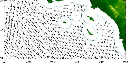
27 Science Retrievals
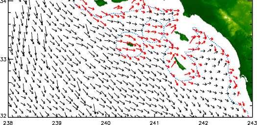
28 Merged Retrievals

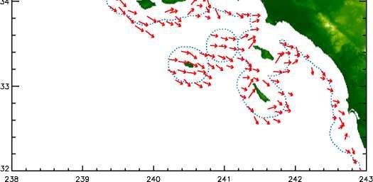
29 Coastal Retrievals
30 Canonical Correlations vs. VC
31 NDBC Buoys


32 NDBC Buoys
Validation of 12.5 km and Super-High Resolution (2-5 km)
") Coastal and Orographic Wind Analyses from High Resolution QuikSCAT and SeaWinds Measurements M.H. Freilich, COAS/OSU D.B. Chelton, COAS/OSU D.G. Long, BYU Clive Dorman, SIO Barry Vanhoff, COAS/OSU OVWST
Coastal and Orographic Wind Analyses from High Resolution QuikSCAT and SeaWinds Measurements M.H. Freilich, COAS/OSU D.B. Chelton, COAS/OSU D.G. Long, BYU Clive Dorman, SIO Barry Vanhoff, COAS/OSU OVWST
Reprocessed QuikSCAT (V04) Wind Vectors with Ku-2011 Geophysical Model Function
 Wind Vectors with Ku-2011 Geophysical Model Function") Reprocessed QuikSCAT (V04) Wind Vectors with Ku-2011 Geophysical Model Function Lucrezia Ricciardulli and Frank Wentz Introduction In April 2011, we reprocessed the QuikSCAT ocean wind vectors using a
Reprocessed QuikSCAT (V04) Wind Vectors with Ku-2011 Geophysical Model Function Lucrezia Ricciardulli and Frank Wentz Introduction In April 2011, we reprocessed the QuikSCAT ocean wind vectors using a
A. Bentamy 1, S. A. Grodsky2, D.C. Fillon1, J.F. Piollé1 (1) Laboratoire d Océanographie Spatiale / IFREMER (2) Univ. Of Maryland
 Laboratoire d Océanographie Spatiale / IFREMER (2) Univ. Of Maryland") Calibration and Validation of Multi-Satellite scatterometer winds A. Bentamy 1, S. A. Grodsky2, D.C. Fillon1, J.F. Piollé1 (1) Laboratoire d Océanographie Spatiale / IFREMER (2) Univ. Of Maryland Topics
Calibration and Validation of Multi-Satellite scatterometer winds A. Bentamy 1, S. A. Grodsky2, D.C. Fillon1, J.F. Piollé1 (1) Laboratoire d Océanographie Spatiale / IFREMER (2) Univ. Of Maryland Topics
Development of SAR-Derived Ocean Surface Winds at NOAA/NESDIS
 Development of SAR-Derived Ocean Surface Winds at NOAA/NESDIS Pablo Clemente-Colón, William G. Pichel, NOAA/NESDIS Frank M. Monaldo, Donald R. Thompson The Johns Hopkins University Applied Physics Laboratory
High resolution wind retrieval for SeaWinds
 High resolution wind retrieval for SeaWinds David G. Long and Jeremy B. Luke Brigham Young University, 459 Clyde Building, Provo, UT 84602, USA ABSTRACT The SeaWinds instrument on the QuikSCAT satellite
Cross-Calibrating OSCAT Land Sigma-0 to Extend the QuikSCAT Land Sigma-0 Climate Record
 Cross-Calibrating OSCAT Land Sigma-0 to Extend the QuikSCAT Land Sigma-0 Climate Record David G. Long Department of Electrical and Computer Engineering Brigham Young University May 2013 0 Scatterometer
SENSOR SYNERGY OF ACTIVE AND PASSIVE MICROWAVE INSTRUMENTS FOR OBSERVATIONS OF MARINE SURFACE WINDS
 SENSOR SYNERGY OF ACTIVE AND PASSIVE MICROWAVE INSTRUMENTS FOR OBSERVATIONS OF MARINE SURFACE WINDS N. Ebuchi Institute of Low Temperature Science, Hokkaido University, N19-W8, Kita-ku, Sapporo 060-0819,
The Ice Contamination Ratio Method: Accurately Retrieving Ocean Winds Closer to the Sea Ice Edge While Eliminating Ice Winds
 The Ice Contamination Ratio Method: Accurately Retrieving Ocean Winds Closer to the Sea Ice Edge While Eliminating Ice Winds David Long Department of Electrical and Computer Engineering Brigham Young University
WaMoS II Wave Monitoring System
 WaMoS II Wave Monitoring System - An application of WaMoS II at Duck - Katrin Hessner, K. Reichert, J. Dannenberg OceanWaveS GmbH, Germany Kent Hathaway, Don Resio Engineering Research Development Center
Jackie May* Mark Bourassa. * Current affilitation: QinetiQ-NA
 Jackie May* Mark Bourassa * Current affilitation: QinetiQ-NA Background/Motivation In situ observations (ships and buoys) are used to validate satellite observations Problems with comparing data Sparseness
PRELIMINARY STUDY ON DEVELOPING AN L-BAND WIND RETRIEVAL MODEL FUNCTION USING ALOS/PALSAR
 PRELIMINARY STUDY ON DEVELOPING AN L-BAND WIND RETRIEVAL MODEL FUNCTION USING ALOS/PALSAR Osamu Isoguchi, Masanobu Shimada Earth Observation Research Center, Japan Aerospace Exploration Agency (JAXA) 2-1-1
SAR images and Polar Lows
 SAR images and Polar Lows Gunnar Noer, Birgitte Furevik, Johannes Röhrs Observing polar lows in 2012: AVHRR Polar orbiting satellite imagery Primary source of info Observations at cloud tops Synoptic observations
Sentinel-1A Ocean Level-2 Products Validation Strategy
 Sentinel-1A Ocean Level-2 Products Validation Strategy Sentinel-1 Mission Performance Centre ESL L2 Team and Ocean Data Lab G.Hajduch (1), A.Mouche (2), P.Vincent (1), R.Husson (1), H.Johnsen (3), F.Collard
HIGH RESOLUTION WIND RETRIEVAL FOR SEAWINDS ON QUIKSCAT. Jeremy B. Luke. A thesis submitted to the faculty of. Brigham Young University
 HIGH RESOLUTION WIND RETRIEVAL FOR SEAWINDS ON QUIKSCAT by Jeremy B. Luke A thesis submitted to the faculty of Brigham Young University in partial fulfillment of the requirements for the degree of Master
On the Quality of HY-2A Scatterometer Winds
 On the Quality of HY-2A Scatterometer Winds W. Lin (ICM-CSIC) M. Portabella (ICM-CSIC) A. Stoffelen (KNMI) A. Verhoef (KNMI) Youguang Zhang (NSOAS) Mingsen Lin (NSOAS) Shuyan Lang (NSOAS) Juhong Zou (NSOAS)
SIMON YUEH, WENQING TANG, ALEXANDER FORE, AND JULIAN CHAUBELL JPL-CALTECH, PASADENA, CA, USA GARY LAGERLOEF EARTH AND SPACE RESEARCH, SEATTLE, WA, US
 Applications of L-Band Scatterometry and Radiometry to Aquarius and SMAP SIMON YUEH, WENQING TANG, ALEXANDER FORE, AND JULIAN CHAUBELL JPL-CALTECH, PASADENA, CA, USA GARY LAGERLOEF EARTH AND SPACE RESEARCH,
HIGH RESOLUTION WIND AND WAVE MEASUREMENTS FROM TerraSAR-X IN COMPARISON TO MARINE FORECAST
 SAR Maritime Applications German Aerospace Center (DLR) Remote Sensing Technology Institute Maritime Security Lab HIGH RESOLUTION WIND AND WAVE MEASUREMENTS FROM TerraSAR-X IN COMPARISON TO MARINE FORECAST
Characterization of ASCAT measurements based on buoy and QuikSCAT wind vector observations
 Ocean Sci., 4, 265 274, 2008 Author(s) 2008. This work is distributed under the Creative Commons Attribution 3.0 License. Ocean Science Characterization of ASCAT measurements based on buoy and QuikSCAT
JET PROPULSION LABORATORY INTEROFFICE MEMORANDUM
 JET PROPULSION LABORATORY INTEROFFICE MEMORANDUM 3348-99-008 June 16, 1999 To: From: CC: Subject: Philip S. Callahan Young-Joon Kim SAPIENT, SVT Validation of the NOAA Processor through a comparison with
The RSS WindSat Version 7 All-Weather Wind Vector Product
 2010 International Ocean Vector Winds Meeting Barcelona, Spain May 18 20, 2010 The RSS WindSat Version 7 All-Weather Wind Vector Product Thomas Meissner Lucrezia Ricciardulli Frank Wentz Outline 1. Overview:
EVALUATION OF ENVISAT ASAR WAVE MODE RETRIEVAL ALGORITHMS FOR SEA-STATE FORECASTING AND WAVE CLIMATE ASSESSMENT
 EVALUATION OF ENVISAT ASAR WAVE MODE RETRIEVAL ALGORITHMS FOR SEA-STATE FORECASTING AND WAVE CLIMATE ASSESSMENT F.J. Melger ARGOSS, P.O. Box 61, 8335 ZH Vollenhove, the Netherlands, Email: info@argoss.nl
Advancements in scatterometer wind processing
 Advancements in scatterometer wind processing Ad.Stoffelen@knmi.nl Marcos Portabella Anton Verhoef Jeroen Verspeek Jur Vogelzang scat@knmi.nl www.knmi.nl/scatterometer Scatterometer work The scatterometer
Evaluation of the HY-2A Scatterometer wind quality
 Evaluation of the HY-2A Scatterometer wind quality Wenming Lin, Marcos Portabella, Antonio Turiel ICM-CSIC Ad Stoffelen, Anton Verhoef KNMI Qingtao Song, Xingwei Jiang NOSAS Dudely B. Chelton OSU Typhoon
Satellite information on ocean vector wind from Scatterometer data. Giovanna De Chiara
 Satellite information on ocean vector wind from Scatterometer data Giovanna De Chiara Why is Scatterometer important? The scatterometer measures the ocean surface winds (ocean wind vector). Ocean surface
THE QUALITY OF THE ASCAT 12.5 KM WIND PRODUCT
 THE QUALITY OF THE ASCAT 12.5 KM WIND PRODUCT Jur Vogelzang, Ad Stoffelen, Maria Belmonte, Anton Verhoef, and Jeroen Verspeek Royal Netherlands Meteorological Institute, Wilhelminalaan 10, 3732 GK, De
Coastal Scatterometer Winds Working Group
 Coastal Scatterometer Winds Working Group IOVWST Meeting 2015 Portland, Oregon, USA Melanie Fewings Julia Figa Saldaña Bryan Stiles Steve Morey Dmitry Dukhovskoy Larry O Neill if you want to be added to
Dynamic validation of Globwave SAR wave spectra data using an observation-based swell model. R. Husson and F. Collard
 Dynamic validation of Globwave SAR wave spectra data using an observation-based swell model. R. Husson and F. Collard Context 1978 1979 1980 1981 1982 1983 1984 1985 1986 1987 1988 1989 1990 1991 1992
TRMM TMI and AMSR-E Microwave SSTs
 TMI and AMSR-E Microwave SSTs Chelle Gentemann, Frank Wentz, & Peter Ashcroft Gentemann@remss.com www.remss.com TMI/AMSR-E MW SST algorithm development Validation Results Sensor Issues Useful for Climate
CHANGE OF THE BRIGHTNESS TEMPERATURE IN THE MICROWAVE REGION DUE TO THE RELATIVE WIND DIRECTION
 JP4.12 CHANGE OF THE BRIGHTNESS TEMPERATURE IN THE MICROWAVE REGION DUE TO THE RELATIVE WIND DIRECTION Masanori Konda* Department of Geophysics, Graduate School of Science, Kyoto University, Japan Akira
OAFlux: global, 0.25, daily
 Including ASCAT in OAFlux Global Vector Wind Analysis (1987 present) with programming support from Dr. Xiangze Jin July 1987 OAFlux: global, 0.25, daily QuikSCAT AMSRE SSMI (F08, F10, F11, F13, F14, F15,
Dynamics and variability of surface wind speed and divergence over mid-latitude ocean fronts
 Dynamics and variability of surface wind speed and divergence over mid-latitude ocean fronts Larry O Neill 1, Tracy Haack 2, and Simon de Szoeke 1 1 Oregon State University, Corvallis, OR 2 Naval Research
OCEAN vector winds from the SeaWinds instrument have
 IEEE GEOSCIENCE AND REMOTE SENSING LETTERS, VOL. 6, NO. 3, JULY 2009 413 Coastal Validation of Ultra-High Resolution Wind Vector Retrieval From QuikSCAT in the Gulf of Maine A. M. Plagge, Student Member,
Aquarius Wind Speed Retrievals and Implica6ons for SMAP Ocean Vector Winds
 Aquarius Wind Speed Retrievals and Implica6ons for SMAP Ocean Vector Winds Alex Fore, Simon Yueh, Wenqing Tang, Julian Chaubell, Gregory Neumann, Akiko Hayashi, and Adam Freedman 214 California Ins6tute
An algorithm for Sea Surface Wind Speed from MWR
 An algorithm for Sea Surface Wind Speed from MWR Carolina Tauro 1, Yazan Heyazin 2, María Marta Jacob 1, Linwood Jones 1 1 Comisión Nacional de Actividades Espaciales (CONAE) 2 Central Florida Remote Sensing
Using several data sources for offshore wind resource assessment
 Author manuscript, published in ", Copenhagen : Denmark (2005)" Ben Ticha M. B., Ranchin T., Wald L., Using several data sources for offshore wind resource assessment, 2005, Using several data sources
Geophysical Model Functions for the Retrieval of Ocean Surface Winds
 Geophysical Model Functions for the Retrieval of Ocean Surface Winds Donald R. Thompson and Frank M. Monaldo Johns Hopkins University Applied Physics Laboratory 11100 Johns Hopkins Road, Laurel, MD 20708
Scatterometer-Based Assessment of 10-m Wind Analyses from the Operational ECMWF and NCEP Numerical Weather Prediction Models
 FEBRUARY 2005 C H E L T O N A N D F R E I L I C H 409 Scatterometer-Based Assessment of 10-m Wind Analyses from the Operational ECMWF and NCEP Numerical Weather Prediction Models DUDLEY B. CHELTON AND
Swell (wind) fields obtained from Satellite Observation CLS Christian Ortega - Mission blue Journées Annuelles des Hydrocarbures 2013
 fields obtained from Satellite Observation CLS Christian Ortega - Mission blue Journées Annuelles des Hydrocarbures 2013") Swell (wind) fields obtained from Satellite Observation CLS Christian Ortega - cortega@cls.fr Mission blue Journées Annuelles des Hydrocarbures 2013 Purpose Develop new methodologies to obtain swell (wind)
Swell (wind) fields obtained from Satellite Observation CLS Christian Ortega - cortega@cls.fr Mission blue Journées Annuelles des Hydrocarbures 2013 Purpose Develop new methodologies to obtain swell (wind)
On the assimilation of SAR wave spectra of S-1A in the wave model MFWAM
 On the assimilation of SAR wave spectra of S-1A in the wave model MFWAM Lotfi Aouf and Alice Dalphinet Météo-France, Département Marine et Océanographie,Toulouse 14 th wave forecasting and hindcasting,
Accuracy of 10 m winds from satellites and NWP products near land-sea boundaries
 JOURNAL OF GEOPHYSICAL RESEARCH, VOL. 113,, doi:10.1029/2007jc004516, 2008 Accuracy of 10 m winds from satellites and NWP products near land-sea boundaries A. B. Kara, 1 A. J. Wallcraft, 1 C. N. Barron,
Combining wind and rain in spaceborne scatterometer observations: modeling the splash effects in the sea surface backscattering coefficient
 Combining wind and rain in spaceborne scatterometer observations: modeling the splash effects in the sea surface backscattering coefficient F. Polverari (1,2,4), F. S. Marzano (1,2), L. Pulvirenti (3,1),
Intraseasonal Variability in Sea Level Height in the Bay of Bengal: Remote vs. local wind forcing & Comparison with the NE Pacific Warm Pool
 Intraseasonal Variability in Sea Level Height in the Bay of Bengal: Remote vs. local wind forcing & Comparison with the NE Pacific Warm Pool Shang-Ping Xie 1,3, Xuhua Cheng 2,3, Julian P. McCreary 3 1.
Review of Equivalent Neutral Winds and Stress
 Review of Equivalent Neutral Winds and Stress Mark A. Bourassa Center for Ocean-Atmospheric Prediction Studies, Geophysical Fluid Dynamics Institute & Department of Earth, Ocean and Atmospheric Science
THE SEAWINDS scatterometer was flown twice, once on
 IEEE TRANSACTIONS ON GEOSCIENCE AND REMOTE SENSING 1 Land-Contamination Compensation for QuikSCAT Near-Coastal Wind Retrieval Michael P. Owen and David G. Long, Fellow, IEEE Abstract The QuikSCAT scatterometer
Monitoring Conditions Offshore with Satellites
 Downloaded from orbit.dtu.dk on: Dec 15, 2017 Monitoring Conditions Offshore with Satellites Karagali, Ioanna; Hasager, Charlotte Bay; Badger, Merete; Bingöl, Ferhat; Ejsing Jørgensen, Hans Publication
Singularity analysis: A poweful technique for scatterometer wind data processing
 Singularity analysis: A poweful technique for scatterometer wind data processing M. Portabella (ICM-CSIC) W. Lin (ICM-CSIC) A. Stoffelen (KNMI) A. Turiel (ICM-CSIC) G. King (ICM-CSIC) A. Verhoef (KNMI)
High Resolution Sea Surface Roughness and Wind Speed with Space Lidar (CALIPSO)
") High Resolution Sea Surface Roughness and Wind Speed with Space Lidar (CALIPSO) Yongxiang Hu NASA Langley Research Center Carl Weimer Ball Aerospace Corp. 1 CALIPSO Mission Overview CALIPSO seeks to improve
High Resolution Sea Surface Roughness and Wind Speed with Space Lidar (CALIPSO) Yongxiang Hu NASA Langley Research Center Carl Weimer Ball Aerospace Corp. 1 CALIPSO Mission Overview CALIPSO seeks to improve
Offshore wind resource mapping in Europe from satellites
 Offshore wind resource mapping in Europe from satellites Charlotte Bay Hasager Seminar at University of Auckland, Dept. of Physics 1 April 2015 Content DTU Wind Energy Offshore wind turbines New European
Study of an Objective Performance Measure for Spaceborne Wind Sensors
 Final Report Study of an Objective Performance Measure for Spaceborne Wind Sensors Maria Belmonte Rivas Jos de Kloe Ad Stoffelen Weather Research Royal Netherlands Meteorological Institute De Bilt, November
THE EFFECT OF RAIN ON ASCAT OBSERVATIONS OF THE SEA SURFACE RADAR CROSS SECTION USING SIMULTANEOUS 3-D NEXRAD RAIN MEASUREMENTS
 THE EFFECT OF RAIN ON ASCAT OBSERVATIONS OF THE SEA SURFACE RADAR CROSS SECTION USING SIMULTANEOUS 3-D NERAD RAIN MEASUREMENTS David E. Weissman Hofstra University Hempstead, New York 11549 Mark A. Bourassa
Deborah K. Smith, Frank J. Wentz, and Carl A. Mears Remote Sensing Systems
 JP 4.9 RESULTS OF QUIKSCAT HIGH WIND DATA VALIDATION Deborah K. Smith, Frank J. Wentz, and Carl A. Mears Remote Sensing Systems ABSTRACT Traditional validation of satellite-derived winds includes comparison
Statistics of wind and wind power over the Mediterranean Sea
 Conférence Méditerranéenne Côtière et Maritime EDITION 2, TANGER, MAROC (2011) Coastal and Maritime Mediterranean Conference Disponible en ligne http://www.paralia.fr Available online Statistics of wind
Assessing the Accuracy of High Spatial Resolution Effort Data
 Assessing the Accuracy of High Spatial Resolution Effort Data Southwest Fisheries Science Center, Ecology Division Comparing VMS and Logbook Data in the California Groundfish Trawl Fishery Alice Thomas-Smyth,
ERS-1/2 Scatterometer new products: mission reprocessing and data quality improvement
 ERS-1/2 Scatterometer new products: mission reprocessing and data quality improvement Giovanna De Chiara (1), Raffaele Crapolicchio (1), Pascal Lecomte (2) (1) Serco SpA Via Sciadonna 22-24 Frascati (Roma),
Assessment and Analysis of QuikSCAT Vector Wind Products for the Gulf of Mexico: A Long-Term and Hurricane Analysis
 Sensors 2008, 8, 1927-1949 sensors ISSN 1424-8220 2008 by MDPI www.mdpi.org/sensors Full Research Paper Assessment and Analysis of QuikSCAT Vector Wind Products for the Gulf of Mexico: A Long-Term and
Energy Output. Outline. Characterizing Wind Variability. Characterizing Wind Variability 3/7/2015. for Wind Power Management
 Energy Output for Wind Power Management Spring 215 Variability in wind Distribution plotting Mean power of the wind Betz' law Power density Power curves The power coefficient Calculator guide The power
Assimilation of Scatterometer Winds at Météo-France
 Assimilation of Scatterometer Winds at Météo-France Christophe Payan, Nathalie Boullot (1), Dominique Mékies (2) (1) CNRM and GAME, Météo-France and CNRS (2) LACy, La Réunion University, CNRS and Météo-France
The Cross-Calibrated Multi-Platform (CCMP) Ocean Vector Wind Analysis (V2.0)
 Ocean Vector Wind Analysis (V2.0)") The Cross-Calibrated Multi-Platform (CCMP) Ocean Vector Wind Analysis (V2.0) Carl A. Mears, L. Ricciardulli, J. Scott and F. J. Wentz Remote Sensing Systems Ross Hoffman, S. Mark Leidner Robert Atlas Atmospheric
The Cross-Calibrated Multi-Platform (CCMP) Ocean Vector Wind Analysis (V2.0) Carl A. Mears, L. Ricciardulli, J. Scott and F. J. Wentz Remote Sensing Systems Ross Hoffman, S. Mark Leidner Robert Atlas Atmospheric
Climate-Quality Intercalibration of Scatterometer Missions
 Climate-Quality Intercalibration of Scatterometer Missions Lucrezia Ricciardulli and Frank Wentz Remote Sensing Systems, Santa Rosa, California IOVWST meeting Sapporo, Japan, May 2016 Photo Courtesy: 1
ON THE USE OF DOPPLER SHIFT FOR SAR WIND RETRIEVAL
 ON THE USE OF DOPPLER SHIFT FOR SAR WIND RETRIEVAL K-F. Dagestad 1, A. Mouche 2, F. Collard 2, M. W. Hansen 1 and J. Johannessen 1 (1) Nansen Environmental and Remote Censing Center, Thormohlens gt 47,
Wind Stress Working Group 2015 IOVWST Meeting Portland, OR
 Wind Stress Working Group 2015 IOVWST Meeting Portland, OR Summary of Research Topics, Objectives and Questions James B. Edson University of Connecticut SPURS Mooring, Farrar, WHOI Background Motivation
Wind Direction Analysis over the Ocean using SAR Imagery
 Journal of Information & Computational Science 5: 1 (2008) 223-231 Available at http: www.joics.com Wind Direction Analysis over the Ocean using SAR Imagery Kaiguo Fan a,b,, Weigen Huang a, Mingxia He
FULL-WAVEFORM INVERSION
 FULL-WAVEFORM INVERSION Overview & application to field data Mike Warner Imperial College London Topics Overview of full-waveform inversion Application to an OBC dataset Validation 2 Overview of FWI 3
Determination of Nearshore Wave Conditions and Bathymetry from X-Band Radar Systems
 Determination of Nearshore Wave Conditions and Bathymetry from X-Band Radar Systems Okey G. Nwogu Dept. of Naval Architecture and Marine Engineering University of Michigan Ann Arbor, MI 48109 Phone: (734)
SeaWinds Validation with Research Vessels
 1 SeaWinds Validation with Research Vessels Mark A. Bourassa 1, David M. Legler 1,, James J. O'Brien 1, and Shawn R. Smith 1 Abstract. The accuracy of vector winds from the SeaWinds scatterometer on the
Fuga. - Validating a wake model for offshore wind farms. Søren Ott, Morten Nielsen & Kurt Shaldemose Hansen
 Fuga - Validating a wake model for offshore wind farms Søren Ott, Morten Nielsen & Kurt Shaldemose Hansen 28-06- Outline What is Fuga? Model validation: which assumptions are tested? Met data interpretation:
Evaluation of Marine Surface Winds Observed by SeaWinds and AMSR on ADEOS-II
 Journal of Oceanography, Vol. 62, pp. 293 to 301, 2006 Evaluation of Marine Surface Winds Observed by SeaWinds and AMSR on ADEOS-II NAOTO EBUCHI* Institute of Low Temperature Science, Hokkaido University,
A GENERALIZED WAVE-RAY APPROACH FOR PROPAGATION ON A SPHERE AND ITS APPLICATION TO SWELL PREDICTION
 A GENERALIZED WAVE-RAY APPROACH FOR PROPAGATION ON A SPHERE AND ITS APPLICATION TO SWELL PREDICTION D. Scott 1, D. Resio 2, D. Williamson 1 1. Baird & Associates, Suite 5, 1145 Hunt Club Road, Ottawa,
JPEG-Compatibility Steganalysis Using Block-Histogram of Recompression Artifacts
 JPEG-Compatibility Steganalysis Using Block-Histogram of Recompression Artifacts Jan Kodovský, Jessica Fridrich May 16, 2012 / IH Conference 1 / 19 What is JPEG-compatibility steganalysis? Detects embedding
IMPROVED OIL SLICK IDENTIFICATION USING CMOD5 MODEL FOR WIND SPEED EVALUATION ON SAR IMAGES
 IMPROVED OIL SLICK IDENTIFICATION USING CMOD5 MODEL FOR WIND SPEED EVALUATION ON SAR IMAGES H.KHENOUCHI & Y. SMARA University of Sciences and Technology Houari Boumediene (USTHB). Faculty of Electronics
ERS WAVE MISSION REPROCESSING- QC SUPPORT ENVISAT MISSION EXTENSION SUPPORT
 REPORT 8/2011 ISBN 978-82-7492-248-8 ISSN 1890-5218 ERS WAVE MISSION REPROCESSING- QC SUPPORT ENVISAT MISSION EXTENSION SUPPORT - Annual Report 2010 Author (s): Harald Johnsen (Norut), Fabrice Collard
Archimer
 Please note that this is an author-produced PDF of an article accepted for publication following peer review. The definitive publisher-authenticated version is available on the publisher Web site Journal
RapidScat wind validation report
 Ocean and Sea Ice SAF Technical Note SAF/OSI/CDOP2/KNMI/TEC/RP/228 25 and 50 km wind products (OSI-109) Anton Verhoef, Jur Vogelzang and Ad Stoffelen KNMI Version 1.1 March 2015 DOCUMENTATION CHANGE RECORD
Aquarius Sca+erometer Calibra3on
 Aquarius Sca+erometer Calibra3on Fore, A., Neumann, G., Freedman, A., Chaubell, M., Tang, W., Hayashi, A., and Yueh, S. 217 California Ins3tute of Technology, Government Sponsorship acknowledged Aquarius
Institut Français pour la Recherche et l Exploitation de la MER
 Institut Français pour la Recherche et l Exploitation de la MER Laboratoire d'océanographie Physique et Spatiale Satellites Interface Air- Mer June 2017 Document IFREMER/LOPS/Long Time Series Satellite
Impact of the tides, wind and shelf circulation on the Gironde river plume dynamics
 Impact of the tides, wind and shelf circulation on the Gironde river plume dynamics F. Toublanc 1, N. Ayoub 2, P. Marsaleix 3, P. De Mey 2 1 CNES/LEGOS 2 CNRS/LEGOS 3 CNRS/LA, Toulouse, France 5th GODAE
TRIAXYS Acoustic Doppler Current Profiler Comparison Study
 TRIAXYS Acoustic Doppler Current Profiler Comparison Study By Randolph Kashino, Axys Technologies Inc. Tony Ethier, Axys Technologies Inc. Reo Phillips, Axys Technologies Inc. February 2 Figure 1. Nortek
COMPARISON OF DEEP-WATER ADCP AND NDBC BUOY MEASUREMENTS TO HINDCAST PARAMETERS. William R. Dally and Daniel A. Osiecki
 COMPARISON OF DEEP-WATER ADCP AND NDBC BUOY MEASUREMENTS TO HINDCAST PARAMETERS William R. Dally and Daniel A. Osiecki Surfbreak Engineering Sciences, Inc. 207 Surf Road Melbourne Beach, Florida, 32951
First studies with the high-resolution coupled wave current model CWAM and other aspects of the project Sea State Monitor
 First studies with the high-resolution coupled wave current model CWAM and other aspects of the project Sea State Monitor Jens Kieser, Thomas Bruns German Meteorological Service (Deutscher Wetterdienst,
PROPAGATION OF LONG-PERIOD WAVES INTO AN ESTUARY THROUGH A NARROW INLET
 PROPAGATION OF LONG-PERIOD WAVES INTO AN ESTUARY THROUGH A NARROW INLET Takumi Okabe, Shin-ichi Aoki and Shigeru Kato Department of Civil Engineering Toyohashi University of Technology Toyohashi, Aichi,
Assessing the quality of Synthetic Aperture Radar (SAR) wind retrieval in coastal zones using multiple Lidars
 wind retrieval in coastal zones using multiple Lidars") Assessing the quality of Synthetic Aperture Radar (SAR) wind retrieval in coastal zones using multiple Lidars Tobias Ahsbahs Merete Badger, Ioanna Karagali, Xiaoli Larsen What is the coastal zone? Coastal
Assessing the quality of Synthetic Aperture Radar (SAR) wind retrieval in coastal zones using multiple Lidars Tobias Ahsbahs Merete Badger, Ioanna Karagali, Xiaoli Larsen What is the coastal zone? Coastal
ERGS are large expanses of sand in the desert. Aeolian
 1164 IEEE TRANSACTIONS ON GEOSCIENCE AND REMOTE SENSING, VOL. 45, NO. 5, MAY 2007 Spatial and Temporal Behavior of Microwave Backscatter Directional Modulation Over the Saharan Ergs Haroon Stephen, Member,
IMPROVED BAYESIAN WIND VECTOR RETRIEVAL SCHEME USING ENVISAT ASAR DATA: PRINCIPLES AND VALIDATION RESULTS
 IMPROVED BAYESIAN WIND VECTOR RETRIEVAL SCHEME USING ENVISAT ASAR DATA: PRINCIPLES AND VALIDATION RESULTS Vincent Kerbaol (1), and the SAR Ocean Wind, Waves and Currents Team (1) BOOST Technologies, 115
IMPROVEMENTS IN THE USE OF SCATTEROMETER WINDS IN THE OPERATIONAL NWP SYSTEM AT METEO-FRANCE
 IMPROVEMENTS IN THE USE OF SCATTEROMETER WINDS IN THE OPERATIONAL NWP SYSTEM AT METEO-FRANCE Christophe Payan CNRM-GAME, Météo-France and CNRS, 42 avenue Gaspard Coriolis, Toulouse, France Abstract Significant
DEVELOPMENT AND VALIDATION OF A SAR WIND EMULATOR
 The Nansen Environmental and Remote Sensing Center a non-profit research institute affiliated with the University of Bergen Thormøhlensgate 47, N-5006 Bergen Norway NERSC Technical Report no. 304 DEVELOPMENT
The Effects of Gap Wind Induced Vorticity, the ITCZ, and Monsoon Trough on Tropical Cyclogenesis
 The Effects of Gap Wind Induced Vorticity, the ITCZ, and Monsoon Trough on Tropical Cyclogenesis Heather M. Holbach and Mark A. Bourassa Center for Ocean-Atmospheric Prediction Studies Department of Earth,
SPATIAL AND TEMPORAL VARIATIONS OF INTERNAL WAVES IN THE NORTHERN SOUTH CHINA SEA
 SPATIAL AND TEMPORAL VARIATIONS OF INTERNAL WAVES IN THE NORTHERN SOUTH CHINA SEA Weigen Huang (1), Johnny Johannessen (2,3), Werner Alpers (4) Jingsong Yang (1), Xilin Gan (1) (1) Second Institute of
Currents measurements in the coast of Montevideo, Uruguay
 Currents measurements in the coast of Montevideo, Uruguay M. Fossati, D. Bellón, E. Lorenzo & I. Piedra-Cueva Fluid Mechanics and Environmental Engineering Institute (IMFIA), School of Engineering, Research
Analyses of Scatterometer and SAR Data at the University of Hamburg
 Analyses of Scatterometer and SAR Data at the University of Hamburg Wind, Waves, Surface Films and Rain ГАДЕ, Мартин Хорстович (aka Martin Gade) Institut für Meereskunde, Universität Hamburg, Германия
Quantifying variance due to temporal and spatial difference between ship and satellite winds
 JOURNAL OF GEOPHYSICAL RESEARCH, VOL. 116,, doi:10.1029/2010jc006931, 2011 Quantifying variance due to temporal and spatial difference between ship and satellite winds Jackie C. May 1,2,3 and Mark A. Bourassa
SEA SURFACE TEMPERATURE RETRIEVAL USING TRMM MICROWAVE IMAGER SATELLITE DATA IN THE SOUTH CHINA SEA
 SEA SURFACE TEMPERATURE RETRIEVAL USING TRMM MICROWAVE IMAGER SATELLITE DATA IN THE SOUTH CHINA SEA Mohd Ibrahim Seeni Mohd and Mohd Nadzri Md. Reba Faculty of Geoinformation Science and Engineering Universiti
The relevance of ocean surface current in the ECMWF analysis and forecast system. Hans Hersbach Jean-Raymond Bidlot
 The relevance of ocean surface current in the ECMWF analysis and forecast system Hans Hersbach Jean-Raymond Bidlot European Centre for Medium Range Weather Forecasts, Reading, U.K. hans.hersbach@ecmwf.int
Comparison of data and model predictions of current, wave and radar cross-section modulation by seabed sand waves
 Comparison of data and model predictions of current, wave and radar cross-section modulation by seabed sand waves Cees de Valk, ARGOSS Summary SAR Imaging of seabed features Seabed Sand waves Objectives
Vika Grigorieva and Sergey Gulev. Sea Atmosphere Interaction And Climate Laboratory P. P. Shirshov Institute of Oceanology, Russia
 Global Ocean Wave Statistics from VOS: a new dataset and associated Atlas Vika Grigorieva and Sergey Gulev Sea Atmosphere Interaction And Climate Laboratory P. P. Shirshov Institute of Oceanology, Russia
GLOBAL VALIDATION AND ASSIMILATION OF ENVISAT ASAR WAVE MODE SPECTRA
 GLOBAL VALIDATION AND ASSIMILATION OF ENVISAT ASAR WAVE MODE SPECTRA Saleh Abdalla, Jean-Raymond Bidlot and Peter Janssen European Centre for Medium-Range Weather Forecasts, Shinfield Park, RG 9AX, Reading,
The Use of ILI In Dent Assessments
 The Use of ILI In Dent Assessments Prepared for: 2014 CRUG Conference Date: 11 September 2014 Prepared by: Rhett Dotson, PE Contributions from Dr. Chris Alexander and Markus Ginten Contents Current Dent
ENVISAT WIND AND WAVE PRODUCTS: MONITORING, VALIDATION AND ASSIMILATION
 ENVISAT WIND AND WAVE PRODUCTS: MONITORING, VALIDATION AND ASSIMILATION Peter A.E.M. Janssen (), Saleh Abdalla (), Jean-Raymond Bidlot (3) European Centre for Medium-Range Weather Forecasts, Shinfield
Imprints of Coastal Mountains on Ocean Circulation and Variability
 Imprints of Coastal Mountains on Ocean Circulation and Variability Shang-Ping Xie 1 with C.-H. Chang 1, W. Zhuang 2, N. Schneider 1, J. Small 3, B. Taguchi 4, and H. Sasaki 4 1 IPRC, University of Hawaii
Wave Prediction in the Santa Barbara Channel
 Wave Prediction in the Santa Barbara Channel OCS Study MMS 2001-055 Final Technical Summary Final Study Report U.S. Department of the Interior Minerals Management Service Pacific OCS Region Wave Prediction
On the quality of high resolution scatterometer winds
 JOURNAL OF GEOPHYSICAL RESEARCH, VOL. 116,, doi:10.1029/2010jc006640, 2011 On the quality of high resolution scatterometer winds Jur Vogelzang, 1 Ad Stoffelen, 1 Anton Verhoef, 1 and Julia Figa Saldaña