Estuaries: Life on the Interface
|
|
|
- Elwin Stafford
- 6 years ago
- Views:
Transcription
1 Material adapted from: Estuaries: Interface between sea and land & Sea Margin Diversity, The Water Sourcebook Grades 9-12, EPA Introduction: Some of the most dynamic areas on Earth are found at the interface of land and sea, especially in areas we know as estuaries. Estuaries can be defined as a semi-enclosed body of water which has a free connection to the open sea and within which seawater is measurably diluted by fresh water derived from land drainage. They are coastal zones (such as bays, lagoons, sounds or sloughs) where freshwater systems/rivers meet and mix with the salty ocean, becoming brackish. In this activity, students will be introduced to the structure of estuarine systems and their formation through modeling and mapping. Objectives: Students will be able to: Identify different coastal regions across Oregon and the U.S. Describe the five different types of estuary structure Describe the function of estuaries in both watersheds and coastal ecosystems Identify where different estuaries are located in Oregon and the U.S. Explain the value of estuaries in maintaining the integrity of natural ecosystems State the impact human use and misuse has on estuaries. Ocean Literacy Principles These activities support: Essential Principle # 5 the ocean supports a great diversity of life and ecosystems Essential Principle # 6 the oceans and humans are inextricably interconnected. Materials: Modeling clay (see recipe below for a biodegradable version) Petri dishes or plastic plates Food coloring Ice trays Hairdryers or heat lamps (optional) Wall map of Oregon Wall map of the United States 5 different colored push pins (Materials in bold are provided by SMILE) Materials provided are enough to support 20 students
2 Handouts/Transparencies: Handout A: Coastal Margins Coastal Margins Transparency Transparencies of Estuary Structures Handout B: Estuary Descriptions Handout C: Estuary Diagram Estuary Transparency Modeling Clay Recipe Set-Up 1. Freeze water colored with food coloring in the ice trays. Part A: Mapping 1. Display the coastal margins transparency. Discuss different types of coastal margins and how these may impact us either directly or indirectly (e.g. if student has eaten seafood, what region did this food source originate from?). Have students follow along with Handout A. 2. Divide students into small groups. Provide each group with different color map pins and have each group attempt to estimate locations of one of the following types of coastal regions on both the Oregon and U.S. map: a. Bay b. Delta c. Estuary d. Fjord e. Sound f. Lagoon g. Gulf Have each group report back how they decided on these locations. Map features? Common knowledge? Did the groups locate more accurately on a state level or on a national level? Part B: Modeling 1. Introduce estuaries, their key function and explain the different types of estuary structure, using the transparencies to help. Brainstorm with the students the key identifying features of estuaries in general. 2. Divide the students into small groups. Provide each group with one of the five estuary descriptions from handout B. Hand out clay and petri dishes/plates and, using their description, have each group construct a coastline with various raised areas corresponding to their estuary structure inside the dish. 3. Provide each group with 3 cubes of colored ice and let them place the ice on their clay model. As the ice melts, have the students note down how the water fills in
3 their model, does this correlate with the formation of this particular estuary structure? Using a hairdryer or heat lamp can speed up the ice melt. Alternatively, these observations could be completed whilst students participate in next part of the class. 4. Display the estuary transparency. Identify and discuss the smaller habitats found in this environment. Have students follow along with handout C. 5. Have each group brainstorm a list of ways estuaries may be so important to marine life and to humans, reporting back to the rest of the class. 6. Using their remaining map pins, ask each group to try and identify examples of their assigned estuary structure on the maps. What features on each map may provide a clue? Students may use the examples identified in the descriptions to help. Wrap Up Summary questions: 1. What types of coastal regions exist? Are there any good local or state examples? 2. What is an estuary? How are they formed? 3. Where might we find different structures of estuaries? Extensions: 1. Discuss how many estuaries have been damaged or heavily impacted by human activity. Talk about value, natural stresses, necessity to humans and restoration. Have each group brainstorm how we can reduce these impacts and create a poster advertising this idea to the public. 2. In groups (determined by number of habitat models being built), have the students make modeling clay by mixing 2 parts flour to 1 part salt with water and vegetable oil. Use the to mold a model that depicts a river, marsh or estuary habitat. The habitat is placed in one section of plywood (~4 x 4 ) form so that it fits beside others creating an entire watershed or coastal region. Straw, astroturf, plastic plants, and wire can be used at students discretion to make realistic features. Areas under water may be painted blue while land features may be painted brown. The finished product should reinforce the concepts of watershed and coastal habitat studies. Vocabulary: Bar-built estuary Type of estuary formed by a series of bars or islands created from offshore depositing
4 sand, washed down by rivers or in from deep water. The sand walks up the continental shelf and stabilizes. A bar-built estuary is usually laterally extended along the shore, and is long, narrow, and low. Bay A body of water partly enclosed by land but with a wide outlet to the sea. Benthic Living on the bottom of a lake or sea; pertaining to the ocean bottom Bioaccumulation To accumulate larger and larger amounts of a toxin within the tissues of organisms in each successive trophic level. Biological magnification (biomagnification) Bioaccumulation occurring through several levels of a food chain; process by which certain substances (such as pesticides or heavy metals) are deposited into a waterway, are eaten by aquatic organisms which are in turn eaten by large birds, animals, or humans, and become concentrated in tissues or internal organs as they move up the food chain. Biotic Living or derived from living things. Channelization The straightening and sometimes deepening of stream or river channels to speed water flow and reduce flooding. A waterway so treated is said to be channelized. However, channelization can cause unstable situations and may cause adverse environmental impacts. Delta A deposit of sand and soil, usually triangular, formed at the mouth of some rivers. Deltaic estuary Type of estuary formed by a delta. Detritus Decomposed or disintegrated organic matter (found in water and on land), and associated microbial elements. Distributary A branch of a river that flows away from the main stream. Drowned river valley Type of estuary that is wider than deep and triangular in shape Emergent Rising from a surrounding liquid. Estuary
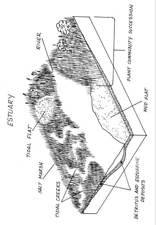
5 A marine ecosystem where freshwater enters the ocean. The term usually describes regions near the mouths of rivers, and includes bays, lagoons, sounds, and marshes. Fjord Narrow, deep valleys carved by glaciers and flooded by the sea. Fjord-drowned glacial valley Type of estuary usually found in arctic and polar regions. They are U-shaped, deeper than wide, and have a small river discharge and large tidal volume; important to shipping. Fluvial Found in, produced by, or relating to a river. Gulf A large area of sea or ocean partially enclosed by land. Interstitial Of, forming, or occurring in a small or narrow space between things or parts. Intertidal Of, or pertaining to a shore zone bounded by the levels of low and high tide. Lagoon A shallow body of water, especially one separated from the sea by sandbars or coral reefs. Leeward In the direction toward which the wind blows; of the side of anything away from the wind. Levee An embankment, natural or artificial, built alongside a river to limit high water events from flooding bordering land. Mangrove swamps Tropical, wet, coastal areas dominated by mangroves (trees). Mangroves have extensive root systems, which form a dense thicket, providing cover for aquatic life. Mud flats Large estuarine expanses composed of rich mud exposed at low tides. Salt marsh Estuarine habitat submerged at high tide, but protected from direct wave action, and overgrown by salt-tolerant herbaceous vegetation; aquatic grasslands (coastal prairies) affected by changing tides, temperatures, and salinity. Sound Long, broad inlet of the ocean larger than a strait or channel, connecting larger bodies of water.
6 Strait A narrow passage that connects two larger bodies of water. Tectonic estuary Type of estuary formed when the Earth s crust shifts suddenly as in an earthquake, volcanic eruption, or a tsunami; has no definite shape. Tidal creeks Meandering creek-like channels within salt marshes and mud flats, through which seawater enters and leaves as the tide rises and falls. Tidal flats Flat-topped banks of sand and silt that comprise the most elevated portion of the salt marsh Tsunami A huge sea wave caused by a submarine disturbance such as an earthquake or volcanic eruption
7 Handout A Coastal Margins
8 Coastal Margins
9 Estuaries: Handout B - Estuary Descriptions (1) COASTAL PLAIN (DROWNED RIVER VALLEY) The classic estuary, wider than deep and triangular in shape, consisting of marshes, mudflats and tidal creeks. Created millions of years ago as ancient glaciers melted, causing rising sea levels that drowned coastal streams and river valleys. Examples include Chesapeake, Delaware, Savannah, Hudson and Columbia River Estuary, OR. (2) FJORD (DROWNED GLACIAL VALLEY) Usually in Arctic or Polar Regions, these are u-shaped, deeper than wide and have a small river discharge with a large tidal volume, hence they are important to shipping. An advancing glacier erodes out long, narrow valleys with steep sides, and when the glacier melts, seawater floods into the remnant valley. Examples are in Puget Sound, WA, Valdez, AK, New Zealand and Norway. (3) DELTAIC The most changeable estuary structure consisting of fluvial depositions with a large river discharge. They form at the mouth of large rivers from sediment and silt deposition, often when river flow is restricted by the river delta itself. They are very prone to the influence of waves, tides, longshore currents, storm damage and sediment lay down. Examples include on the Mississippi River, Amazon River and Nile River. (4) BAR-BUILT The most dynamic of estuary structures, a series of bars or islands created from offshore deposition of sand, washed down by rivers or from deep water, creates a protected area fed by small streams. Bar-built estuaries, usually laterally extended along the shore, are long, narrow and low-lying, such as near sand spits or barrier islands. Some have such low river flow in summer they become blind estuaries an offshore sand bar size increasing so much it closes off the mouth of the estuary (e.g. Sixes River, OR). Bar-built estuaries exist on the leeward side of the river, changing quickly with oceanic movements. Examples include the Mississippi Sound, Cape Cod, Long Island and Salmon River, OR. (5) TECTONIC These estuaries form when the Earth s crust shifts suddenly such as during an earthquake, volcanic eruption, or a tsunami. The shift creates a large land sink in the Earth below sea level, which subsequently fills with water. Tectonic estuaries have no definite shape. A good example is San Francisco Bay.


10 Coastal Plain Fjord

11 Deltaic Bar-Built

12 Tectonic

13 Handout C Estuary
14 Estuary
15 Modeling Clay Recipe Taken from Ingredients: 2 Cups Plain Flour 1 Cup Salt 1 to 1½ Cups water 2 Tbsp Vegetable/Mineral Oil Food coloring (optional) Makes about 2 cups of dough Directions: 1. In a mixing bowl, stir together flour and salt. Add food coloring if desired. 2. Gradually add water and oil until mixture becomes a dough-like consistency. Add more water/flour if mixture is too dry/wet. 3. Knead the dough well until it forms a soft ball. 4. Dough can be air-dried or baked in the oven at 300 F until hard.
Types of Estuaries and Mixing Patterns. Mrs. Stahl Marine Science Honors
 Types of Estuaries and Mixing Patterns Mrs. Stahl Marine Science Honors Coastal Plain Form between glacial periods, when water from melting glaciers raises the sea level and floods coastal plains and low
5/8/2018. Estuaries are classified by: > Mode of formation e.g. glaciers, deposition, sea level rise. > Patterns of water circulation
 Prepared by Diana Wheat-LBCC Compare and contrast the various types of estuaries, including their origin, size, shape, and general location on earth. Distinguish and describe the different types of habitats
Examples of estuaries include bays, sounds, salt marshes, mangrove forests, mud flats, swamps, inlets, and sloughs.
 An estuary is a partially enclosed body of water where incoming seawater is mixed with fresh water coming from the land. Examples of estuaries include bays, sounds, salt marshes, mangrove forests, mud
CHAPTER 11.1 THE WORLD OCEAN MARINE BIOMES NOTES
 CHAPTER 11.1 THE WORLD OCEAN MARINE BIOMES NOTES 1. The world ocean can be divided into zones both and. The,, and zones that apply to large lakes also apply to the ocean. 2. In addition to the depth zones,
Chapter 12: Coasts (after a brief review of Tides)
") Chapter 12: Coasts (after a brief review of Tides) 1 Questions from previous classes: What happens when a wave meets a current? wave = people walking current = bus If wave goes with the current, the wave
Chapter 12: Coasts (after a brief review of Tides) 1 Questions from previous classes: What happens when a wave meets a current? wave = people walking current = bus If wave goes with the current, the wave
Shore - place where ocean meets land Coast - refers to the larger zone affected by the processes that occur at this boundary.
 Waves, Beaches, and Coasts Shore - place where ocean meets land Coast - refers to the larger zone affected by the processes that occur at this boundary. Waves: energy moving through water The height of
Essentials of Oceanography Eleventh Edition
 Chapter Chapter 1 10 Clickers Lecture Essentials of Oceanography Eleventh Edition The Coast: Beaches and Shoreline Processes Alan P. Trujillo Harold V. Thurman Chapter Overview Coastal regions have distinct
Overview. Beach Features. Coastal Regions. Other Beach Profile Features. CHAPTER 10 The Coast: Beaches and Shoreline Processes.
 Overview CHAPTER 10 The Coast: Beaches and Shoreline Processes Coastal regions constantly change. The beach is a dominant coastal feature. Wave activity continually modifies the beach and coastal areas.
Marginal Marine Environments
 Marginal Marine Environments Delta: discrete shoreline protuberances formed where rivers enter oceans, semi-enclosed seas, lakes or lagoons and supply sediment more rapidly than it can be redistributed
Today: Coastal Issues and Estuaries
 Today: Coastal Issues and Estuaries Coastal issues Human effect on coastlines What is an estuary Why are they so important? Circulation of water in estuary Environmental issues Coastal Issues: Problem
UNDERSTANDING YOUR ESTUARY Level IA- ESTUARY SEARCH
 UNDERSTANDING YOUR ESTUARY Level IA- ESTUARY SEARCH Kakagon/Bad River Sloughs, a Lake Superior estuary located on the Bad River Reservation near Ashland, WI. GOAL Select one Wisconsin estuary to study
Chesil Beach, Dorset UK High energy, shingle coastline. Brighton Beach, Sussex UK Pebble beach
 Beaches: Depositional landform Extends from the highest high tide to the lowest low tide. Very important temporary store in coastal system. Accretion: sediment returning to the visible portion of a beach
Chapter - Oceans and Coasts
 Chapter - Oceans and Coasts Discussion: What do oceans contribute to the environment of Earth? How do Earth s major systems relate to the oceans? Oceans and Coasts Oceans are important - Thermal regulation
Montessori for Everyone 2013 Types of Coastlines
 Coast The coast is the part of the land that borders the sea. It is subject to constant change, as the result of the waves and deposits carried by water onto the land. Coastline The coastline is where
Marine Ecosystems. Aquatic Ecosystems Section 2
 Marine Ecosystems Marine ecosystems are located mainly in coastal areas and in the open ocean. Organisms that live in coastal areas adapt to changes in water level and salinity. Organisms that live in
Coastal management has lagged behind the growth in population leading to problems with pollution
 Fifty percent of the population of the industrialized world lives within 100 km of a coast. Coastal management has lagged behind the growth in population leading to problems with pollution and natural
WHAT ARE ECOSYSTEMS? Dr. V. N. Nayak Professor of Marine Biology (Retd)
") WHAT ARE ECOSYSTEMS? Dr. V. N. Nayak Professor of Marine Biology (Retd) An ECOSYSTEM is an interacting system of plant, animals, and humans and the surrounding environment. An ecosystem contains living
WHAT ARE ECOSYSTEMS? Dr. V. N. Nayak Professor of Marine Biology (Retd) An ECOSYSTEM is an interacting system of plant, animals, and humans and the surrounding environment. An ecosystem contains living
Coastal issues: Beaches and Estuaries. Recent Sea Level: Beaches: Baltimore D.C. Patomac R. Chesapeake Bay
 Coastal issues: Beaches and Estuaries Definitions: Coast = broad zone where both marine & terrestrial processes act It includes the beach, lagoons, marshes, bars etc. Coastal processes act to shape the
General Coastal Notes + Landforms! 1
 General Coastal Notes + Landforms! 1 Types of Coastlines: Type Description Primary Coast which is essentially in the same condition when sea level stabilized Coastline after the last ice age, younger.
Tidally influenced environments. By Alex Tkaczyk, Henrique Menezes, and Isaac Foli
 Tidally influenced environments By Alex Tkaczyk, Henrique Menezes, and Isaac Foli Goals and aims Describe the role of tidal influence in depositional environments. - Deltas - Estuaries Provide an overview
Dynamic Shoreline. Why do we care? Loss of land Damage to structures Recreation
 Dynamic Shoreline Why do we care? Loss of land Damage to structures Recreation Coastal Water Movement Waves provide the energy Through breaking As waves shoal Speed decreases Height increases Wavelength
Warm-up # 7 A day 5/17 - B day 5/18 UPDATE YOUR TABLE OF CONTENTS
 Warm-up # 7 A day 5/17 - B day 5/18 UPDATE YOUR TABLE OF CONTENTS Question: List all examples of surface water on Earth. Answer: Rivers and streams, lakes and reservoirs, (ponds) wetlands, estuaries and
Chapter 10 Lecture Outline. The Restless Oceans
 Chapter 10 Lecture Outline The Restless Oceans Focus Question 10.1 How does the Coriolis effect influence ocean currents? The Ocean s Surface Circulation Ocean currents Masses of water that flow from one
SALINITY. It's the amount of dissolved salts the water contains.
 AQUATIC ECOSYSTEMS SALINITY The types of organisms in an aquatic ecosystem depend upon the water s Salinity. It's the amount of dissolved salts the water contains. Salinity determines the two main aquatic
There are many different kinds of beaches which are generally characterized by the dominance of waves, tides, rivers and currents, and in particular
 Fig. 11-11, p. 253 There are many different kinds of beaches which are generally characterized by the dominance of waves, tides, rivers and currents, and in particular differ by the amount of energy, which
Reading Material. Inshore oceanography, Anikouchine and Sternberg The World Ocean, Prentice-Hall
 Reading Material Inshore oceanography, Anikouchine and Sternberg The World Ocean, Prentice-Hall BEACH PROCESSES AND COASTAL ENVIRONMENTS COASTAL FEATURES Cross section Map view Terminology for Coastal
The Movement of Ocean Water. Currents
 The Movement of Ocean Water Currents Ocean Current movement of ocean water that follows a regular pattern influenced by: weather Earth s rotation position of continents Surface current horizontal movement
Types of Freshwater Ecosystems. Streams originate from underground water. Rivers form when streams join together. Freshwater Biome
 Definition Streams originate from underground water sources Types of Freshwater Ecosystems Streams Rivers Rivers form when streams join together Freshwater Lakes Ponds Basic Characteristics Directional
Formation and characteristics of different types of beaches
 Activity Title: Formation and characteristics of different types of beaches Focusing questions What different types of beaches are there in New Zealand? How are estuaries different to open coastal sandy
Questions # 4 7 refer to Figure # 2 (page 321, Fig )
") Shoreline Community College OCEANOGRAPHY 101 Fall 2006 Sample Exam # 3 Instructor: Linda Khandro Questions # 1 3 refer to Figure # 1 (page 284, Fig 11.7) 1. At which position is the moon in its new moon
Shoreline Community College OCEANOGRAPHY 101 Fall 2006 Sample Exam # 3 Instructor: Linda Khandro Questions # 1 3 refer to Figure # 1 (page 284, Fig 11.7) 1. At which position is the moon in its new moon
Definitions. The environment is the biological, chemical, physical, and social conditions that surround organisms.
 Marine Ecosystems Definitions An ecosystem is a geographically specified system of organisms (including humans), the environment, and the processes that control its dynamics. The environment is the biological,
LAB: WHERE S THE BEACH
 Name: LAB: WHERE S THE BEACH Introduction When you build a sandcastle on the beach, you don't expect it to last forever. You spread out your towel to sunbathe, but you know you can't stay in the same spot
Oceans and Coasts. Chapter 18
 Oceans and Coasts Chapter 18 Exploring the oceans The ocean floor Sediments thicken and the age of the seafloor increases from ridge to shore The continental shelf off the northeast United States Constituent
Natural Bridges Field Trip Activity
 Natural Bridges Field Trip Activity This is due in class on MONDAY- March 1 - not in sections! Name TA: NOTE ON THE GRADING OF THIS ASSIGNMENT: Many of the questions below (especially in the tidepool part)
What is an Estuary? Importance of Estuaries. Importance of Estuaries. Importance of Estuaries
 Oceanography 101, Richard Strickland Lecture 20 What is an Estuary? Portion of the ocean that is semi-enclosed by land and diluted by freshwater runoff All estuaries are embayments But embayments without
Figure 1. Schematic illustration of the major environments on Mustang Island.
 STOP #1: PACKERY CHANNEL BEACH TO BAY We will start this field guide near the north jetty of Packery Channel and hike across the island to Corpus Christi Bay (fig. 1). The island emerges from the Gulf
Lecture Outlines PowerPoint. Chapter 15 Earth Science, 12e Tarbuck/Lutgens
 Lecture Outlines PowerPoint Chapter 15 Earth Science, 12e Tarbuck/Lutgens 2009 Pearson Prentice Hall This work is protected by United States copyright laws and is provided solely for the use of instructors
BEACH PROCESSES AND COASTAL ENVIRONMENTS
 BEACH PROCESSES AND COASTAL ENVIRONMENTS COASTAL FEATURES Cross section Map view TOPICS: Terminology Waves Beach Morphology Barriers Coastal Migration Tides Tidal Flats and Marshes Sediment Budgets Human
Estuarine Shoreline Stabilization
 Estuarine Shoreline Stabilization Property Owner s Guide to Determining the Most Appropriate Stabilization Method Estuarine shorelines are dynamic features that experience continued erosion. Land is lost
COASTAL SYSTEMS WAVE ENERGY
 WAVE ENERGY The energy of a wave determines its ability to erode and transport material on the coast Wave energy depends on the fetch, the distance the wind has blown the wave Wind strength and wind duration
Tidal energy is produced by the surge of ocean waters during the rise and fall of tides. Tidal energy is a renewable source of energy.
 Encyclopedic Entry For Educator tidal energy For the complete encyclopedic entry with media resources, visit: http://www.connectenergyed.org/education/encyclopedia/tidal-energy/ Tidal energy is produced
Your web browser (Safari 7) is out of date. For more security, comfort and the best experience on this site: Update your browser Ignore
 is out of date. For more security, comfort and the best experience on this site: Update your browser Ignore") Your web browser (Safari 7) is out of date. For more security, comfort and the best experience on this site: Update your browser Ignore ESTU ARY wetland For the complete encyclopedic entry with media resources,
Your web browser (Safari 7) is out of date. For more security, comfort and the best experience on this site: Update your browser Ignore ESTU ARY wetland For the complete encyclopedic entry with media resources,
Draw a picture of a water source. Don t forget to include yourself in the picture!
 Name Date Draw a picture of a water source. Don t forget to include yourself in the picture! My water source is Students describe the characteristics of a water source: stream, river, lake, pond, ocean,
4/20/17. #30 - Coastlines - General Principles Coastlines - Overview
 Writing Assignment Due one week from today by 11:59 pm See main class web pages for detailed instructions Essays will be submitted in Illinois Compass (instructions later) Pick one: Earthquakes, tsunamis,
Survival in an Estuary. Life in a Transition Zone
 Estuary An estuary is a semi-enclosed coastal body of water which has a free connection with the open sea and within which sea water is measurably diluted with fresh water derived from land drainage. (D.
The Oregon Coast Education Program. Concepts to Teach: Tidal cycles, interconnectedness and balance
 Tides of the Estuary Adapted from TIDES Activity 4- South Slough NERR Time requirement: 45 minutes Summary of Activity: This lesson is designed to give an introduction to how tides and tidal cycles work
Shorelines Earth - Chapter 20 Stan Hatfield Southwestern Illinois College
 Shorelines Earth - Chapter 20 Stan Hatfield Southwestern Illinois College The Shoreline A Dynamic Interface The shoreline is a dynamic interface (common boundary) among air, land, and the ocean. The shoreline
What happens to Oregon s tidal wetlands with sea level rise?
 What happens to Oregon s tidal wetlands with sea level rise? Laura Brophy Estuary Technical Group Institute for Applied Ecology Corvallis, OR Laura@appliedeco.org Project maps future tidal wetlands, predicts
Ch19&21 Test. Multiple Choice Identify the choice that best completes the statement or answers the question.
 Ch19&21 Test Multiple Choice Identify the choice that best completes the statement or answers the question. 1. A large body of saline water that may be surrounded by land is a(n) a. submersible. c. global
What is an ocean current? 1. wind action: the force of the wind blowing over the top of the water 2. spin of Earth 3. shape of the continents
 Ocean Currents Textbook pages 414 427 Before You Read Section 11.2 Summary What forces do you think cause ocean water to move? Do you think ocean water moves the same way everywhere in the ocean? Write
* Appalachian Mountains -the mountain range in the Eastern U.S. which terminates in north-central Alabama
 MR. SAND TEACHER'S MANUAL INTRODUCTION: Although Mr. Sand is a cartoon presentation that is attractive to children (of all ages), the material is technically accurate and quite significant to our understanding
NYS Coastal Waters. Water Resources of NYS: THE NATURE of the COASTAL ZONE. NYS Coastal Waters. NYS Coastal Atlas. Coastal Zone Management 10/10/2014
 Water Resources of NYS: THE NATURE of the COASTAL ZONE NYS Coastal Waters NYS is the only state to border the Atlantic Ocean and the Great Lakes (Lakes Erie and Ontario). Great Lakes shoreline: 577 miles
Your web browser (Safari 7) is out of date. For more security, comfort and the best experience on this site: Update your browser Ignore
 is out of date. For more security, comfort and the best experience on this site: Update your browser Ignore") Your web browser (Safari 7) is out of date. For more security, comfort and the best experience on this site: Update your browser Ignore TIDAL BO RE For the complete encyclopedic entry with media resources,
Your web browser (Safari 7) is out of date. For more security, comfort and the best experience on this site: Update your browser Ignore TIDAL BO RE For the complete encyclopedic entry with media resources,
Chapter 22, Section 1 - Ocean Currents. Section Objectives
 Chapter 22, Section 1 - Ocean Currents Section Objectives Intro Surface Currents Factors Affecting Ocean Currents Global Wind Belts (you should draw and label a diagram of the global wind belts) The Coriolis
page - Laboratory Exercise #5 Shoreline Processes
 page - Laboratory Exercise #5 Shoreline Processes Section A Shoreline Processes: Overview of Waves The ocean s surface is influenced by three types of motion (waves, tides and surface currents). Shorelines
The Chesapeake Bay as an Estuary: An introduction. Istvan A. Urcuyo Gettysburg College
 The Chesapeake Bay as an Estuary: An introduction. Istvan A. Urcuyo Gettysburg College The Chesapeake Bay -Native Americans resided on its shores since 8000 B.C. The Chesapeake Bay -Original Native American
1.5 Understand how ocean waves and currents change the face of coastal areas. (Chapter 3)
") 1.5 Understand how ocean waves and currents change the face of coastal areas. (Chapter 3) 1. Hydraulic Action/Pressure - air being forced into crack in rocks. 2. Corrosion (Solution) Minerals such as calcium
1.5 Understand how ocean waves and currents change the face of coastal areas. (Chapter 3) 1. Hydraulic Action/Pressure - air being forced into crack in rocks. 2. Corrosion (Solution) Minerals such as calcium
Your web browser (Safari 7) is out of date. For more security, comfort and the best experience on this site: Update your browser Ignore
 is out of date. For more security, comfort and the best experience on this site: Update your browser Ignore") Your web browser (Safari 7) is out of date. For more security, comfort and the best experience on this site: Update your browser Ignore TIDAL ENERGY For the complete encyclopedic entry with media resources,
Your web browser (Safari 7) is out of date. For more security, comfort and the best experience on this site: Update your browser Ignore TIDAL ENERGY For the complete encyclopedic entry with media resources,
1 Shoreline Erosion and Deposition
 CHAPTER 12 1 Shoreline Erosion and Deposition SECTION Agents of Erosion and Deposition BEFORE YOU READ After you read this section, you should be able to answer these questions: What is a shoreline? How
Directed Reading. Section: Ocean Currents. a(n). FACTORS THAT AFFECT SURFACE CURRENTS
. FACTORS THAT AFFECT SURFACE CURRENTS") Skills Worksheet Directed Reading Section: Ocean Currents 1. A horizontal movement of water in a well-defined pattern is called a(n). 2. What are two ways that oceanographers identify ocean currents? 3.
Skills Worksheet Directed Reading Section: Ocean Currents 1. A horizontal movement of water in a well-defined pattern is called a(n). 2. What are two ways that oceanographers identify ocean currents? 3.
Living Shorelines. Created by: JoAnn Moody & Tina Miller-Way Discovery Hall Programs Dauphin Island Sea Lab
 Living Shorelines Created by: JoAnn Moody & Tina Miller-Way Discovery Hall Programs Dauphin Island Sea Lab Living Shorelines Subject: Life Science Grade Level: 6 th -8 th Time Required: 60 min Key Terms:
1. Distribute the activity sheet, and allow 20 minutes for the first use.
 A LOCAL WAY OF LEARNING Title: MISSING MANGROVE MESSAGE Author: Eulalie R. Rivera Elementary School Environmental Education Team Grade Level: 4-6 Concepts: 2.Ecosystem 6.Resources 9.Change Disciplines:
The Surge of the Storm By Margaret Olsen and Katie Greganti
 The Surge of the Storm By Margaret Olsen and Katie Greganti Grade Level: 5-12 Type of Activity: Hands on Focus Question: How does a hurricane s storm surge of a hurricane affect the low-lying areas along
Nearshore Sediment Transport What influences the loss of sediment on Beaches? - Waves - Winds - Tidal Currents - River discharge - Runoff
 Tides & Beaches Nearshore Sediment Transport What influences the loss of sediment on Beaches? - Waves - Winds - Tidal Currents - River discharge - Runoff Oceans Ocean Topography Physical Structure of the
1.5 How do ocean waves and currents change the face of coastal areas? (Chapter 3)
") 1.5 How do ocean waves and currents change the face of coastal areas? (Chapter 3) 1. Hydraulic Action/Pressure - air being forced into crack in rocks. 2. Corrosion (Solution) Minerals such as calcium carbonate
1.5 How do ocean waves and currents change the face of coastal areas? (Chapter 3) 1. Hydraulic Action/Pressure - air being forced into crack in rocks. 2. Corrosion (Solution) Minerals such as calcium carbonate
The Case of the Disappearing Shoreline
 Name The Case of the Disappearing Shoreline Humans change the earth's climate in many ways. One change is the increase of carbon dioxide in the atmosphere. As we burn more fossil fuels, we release more
Feasibility Study for Restoration of Titlow Lagoon Fish Passage. South Puget Sound Salmon Enhancement Group
 Feasibility Study for Restoration of Titlow Lagoon Fish Passage South Puget Sound Salmon Enhancement Group January 2010 Feasibility Study for Restoration of Titlow Lagoon Fish Passage Prepared for South
UNDERSTANDING STORM SURGE
 The Education Program at the New Jersey Sea Grant Consortium 22 Magruder Road, Fort Hancock, NJ 07732 (732) 872-1300 www.njseagrant.org UNDERSTANDING STORM SURGE ACTIVITY 6 SURGE OF THE STORM http://secoora.org/classroom/virtual_hurricane/surge_of_the_storm>
For Creative Minds. Salt Marsh Plants and Animals
 For Creative Minds The For Creative Minds educational section may be photocopied or printed from our website by the owner of this book for educational, non-commercial uses. Cross-curricular teaching activities,
COASTAL ENVIRONMENTS. 454 lecture 12
 COASTAL ENVIRONMENTS Repeated movement of sediment & water constructs a beach profile reflecting the balance between average daily or seasonal wave forces and resistance of landmass to wave action Coasts
The Composition of Seawater
 The Composition of Seawater Salinity Salinity is the total amount of solid material dissolved in water. Most of the salt in seawater is sodium chloride, common table salt. Element Percent Element Percent
MARSH DEGRADATION AT THE MOUTH OF MOORE CREEK
 MARSH DEGRADATION AT THE MOUTH OF MOORE CREEK Hunter Winstanley, Department of Earth Sciences, University of South Alabama, Mobile, AL 36688. E-Mail: hcw501@jaguar1.usouthal.edu. Moore Creek is located
Imagine that you can see a side view of a wave as it approaches a beach. Describe how the wave changes as the wave approaches the beach.
 Geology 101 Name Reading Guide for Ch. 19: Shores and Coastal Processes (p. 612) Waves, Currents, and Tides (p. 614) Waves and Currents (p. 614) Imagine that you can see a side view of a wave as it approaches
Chapter. The Dynamic Ocean
 Chapter The Dynamic Ocean An ocean current is the mass of ocean water that flows from one place to another. 16.1 The Composition of Seawater Surface Circulation Surface Currents Surface currents are movements
Ballast. Stability Lab Experiment. Have you ever been in a boat at sea in large waves? The boat moves up and down as the waves pass under the boat.
 Ballast & Stability Lab Experiment Have you ever been in a boat at sea in large waves? The boat moves up and down as the waves pass under the boat. In the Gulf of Mexico and other areas of the world, waves
Dr. Prakash N. Mesta
 Coastal Wetland Monitoring Dr. Prakash N. Mesta prakashhonavar@gmail.com Coastal Ecosystem is diverse in nature Most of the world human population p settled in Coastal region. Cities & Industries established
Puget Sound Nearshore Ecosystem Restoration Project Restore America s Estuaries Conference 2012 Tampa, FL
 Restore America s Estuaries Conference 2012 Tampa, FL presented by: Theresa Mitchell, WA Dept. of Fish & Wildlife Nearshore General Investigation Change Analysis: Comparison of historical and current
EVALUATING THE EFFECTS OF BIVALVE SHELLFISH AQUACULTURE AND ITS ECOLOGICAL ROLE IN THE ESTUARINE ENVIRONMENT IN THE UNITED STATES
 EVALUATING THE EFFECTS OF BIVALVE SHELLFISH AQUACULTURE AND ITS ECOLOGICAL ROLE IN THE ESTUARINE ENVIRONMENT IN THE UNITED STATES Brett Dumbauld USDA Agricultural Research Service, Hatfield Marine Science
Oceans Humans both depend on it and threaten it with their activities
 Oceans Humans both depend on it and threaten it with their activities Oceans Water covers nearly ¾ of the Earth s surface More than 50% of the world s population lives within an hour of the coast Oceans
Full Name Class Date. 1. Draw and describe your prediction of what will happen to the eggplant after the teacher applies salt to it.
 Full Name Class Date Investigation Booklet Exploring: Salt in Our Lives 1. Draw and describe your prediction of what will happen to the eggplant after the teacher applies salt to it. Use these ecosystem
Ocean Motion Notes. Chapter 13 & 14
 Ocean Motion Notes Chapter 13 & 14 What is a Wave? Wave: movement of energy through a body of water How are Waves Caused? Caused mostly by wind Wind blowing on the water transmits energy to the water Size
Canada s Natural Systems. Canadian Geography 1202
 Canada s Natural Systems Canadian Geography 1202 Canada s Natural Systems Natural System: A system found in nature Here are the four natural systems that we will explore in the next few weeks 1. Canada
SCI-5 MES_Lamb_Oceans Exam not valid for Paper Pencil Test Sessions
 SCI-5 MES_Lamb_Oceans Exam not valid for Paper Pencil Test Sessions [Exam ID:53S2JF 1 Two children are swimming and jumping in the waves at the beach. On which part of the ocean are they standing? A Abyssal
MARSH EXPLORERS Grades 2-3
 MARSH EXPLORERS Grades 2-3 NJCCCS: 5.1, 5.3, 5.4 Field Trip Overview: On your field trip, you and your students will explore a salt marsh within an estuary. Following a brief introduction to the habitat,
UNIT 1: WATER SYSTEMS ON EARTH CHAPTER 3
 UNIT 1: WATER SYSTEMS ON EARTH CHAPTER 3 HEAT CAPACITY HEAT CAPACITY (SPECIFIC HEAT CAPACITY) IS THE AMOUNT OF HEAT THAT A SUBSTANCE CAN HOLD WATER HAS A HIGH HEAT CAPACITY IT CAN TAKE IN A LARGE AMOUNT
Coastal Zones. Coastal Zones
 Page 1 of 15 EENS 3050 Tulane University Natural Disasters Prof. Stephen A. Nelson Coastal Zones Coastal Zones A coastal zone is the interface between the land and water. These zones are important because
X.B WETLANDS ROGUE RIVER ESTUARY
 X.B WETLANDS ROGUE RIVER ESTUARY The Rogue River has a drainage area of 5,100 square miles, yet the estuary of the Rogue River is one of the smallest in Oregon, measuring approximately 1,880 acres during
Estuaries. Lecture 18
 Estuaries Lecture 18 Estuaries. Estuaries are places where fresh and salt water mix. Typically they occur where rivers enter the sea. Estero Limantour, Drakes Bay, Point Reyes National Seashore. Estuary
Species Conclusions Table
 Conclusions Table Project Name: Chesapeake Landing HOA- Breakwaters (NAO-14-0283) Date: February 25, 2014 /Resource Name Loggerhead sea turtle (Caretta caretta) Conclusion ESA Section 7 / Eagle Act Determination
3.9 FROM ISLANDS TO ATOLLS
 3.9 1 3.9 FROM ISLANDS TO ATOLLS OBJECTIVES The students Listen to a description of the formation of volcanic islands, fringing reefs, barrier reefs, and atolls. Observe and participate in a simulation
170 points. 38 points In your textbook, read about modern oceanography. For each item write the word that meets the description.
 Ch 15 Earth s Oceans SECTION 15.1 An Overview of Oceans 38 points In your textbook, read about modern oceanography. For each item write the word that meets the description. (5 points) 1. German research
Indian River Lagoon: Lessons, Challenges and Opportunities
 Indian River Lagoon: Lessons, Challenges and Opportunities Upper Chain of Lakes Lake Kissimmee Kissimmee River Indian River Lagoon Caloosahatchee Estuary Lake Okeechobee St. Lucie Estuary Mark Perry, Executive
Deep Water Currents Lab
 Deep Water Currents Lab Background: Anyone visiting the seashore is struck by the constant motion of water traveling on the surface of the ocean in the form of waves. But beneath the ocean's surface, water
Coasts. 1. Coastal Processes. 1.1 Coastal erosion. 1.2 Sediment transport. Coastal Processes and Landforms. i. Hydraulic action
 Coasts Coastal Processes and Landforms 1. Coastal Processes 1.1 Coastal erosion i. Hydraulic action When waves strike against a rock surface, the waves trap air in the rock joints. This air is compressed
Teacher Guide Earth Science Module Activity 1: Observing Estuaries
 Teacher Guide Earth Science Module Activity 1: Observing Estuaries Featured NERRS Estuary: Weeks Bay NERR (Alabama) http://www.nerrs.noaa.gov/ Reserve.aspx?ResID=WKB Activity Summary In this activity,
SUBJECT: EARTH SCIENCE PAPER: THE DYNAMIC EARTH. Code : 27 COASTAL PROCESSES AND LANDFORMS PROF. A. BALASUBRAMANIAN
 SUBJECT: EARTH SCIENCE PAPER: THE DYNAMIC EARTH Code : 27 TOPIC: COASTAL PROCESSES AND LANDFORMS BY PROF. A. BALASUBRAMANIAN Objectives After attending this module, the user would be able to understand
FINAL TEST. Marks:45/45. The lakes. Fill in the gaps with the following words.
 NAME SURNAME.. CLASS DATE. FINAL TEST Marks:45/45 The lakes Marks: 13/13 Fill in the gaps with the following words. Volcanic - glacial - artificial water power long - sea In Italy there are several large
CHAPTER 8 ASSESSMENT OF COASTAL VULNERABILITY INDEX
 124 CHAPTER 8 ASSESSMENT OF COASTAL VULNERABILITY INDEX 8.1 INTRODUCTION In order to assess the vulnerability of the shoreline considered under this study against the changing environmental conditions,
Controlling Coastal erosion
 Controlling Coastal erosion Coastal Erosion Rates in the U.S. Coastal Erosion and Stabilization Economic pressures demanding the stabilization of beaches and coastlines are immense Coastal Erosion and
Fish Conservation and Management
 Fish Conservation and Management CONS 486 Ocean ecosystems Ross Chapter 2 Topics Physical/temperature zones Magnitude/types of currents Major theme: Linking science to conservation & management Physiology