6.0 PEDESTRIAN AND BICYCLE FACILITIES 6.1 INTRODUCTION 6.2 BICYCLE DEMAND AND SUITABILITY Bicycle Demand
|
|
|
- Nathan O’Connor’
- 5 years ago
- Views:
Transcription
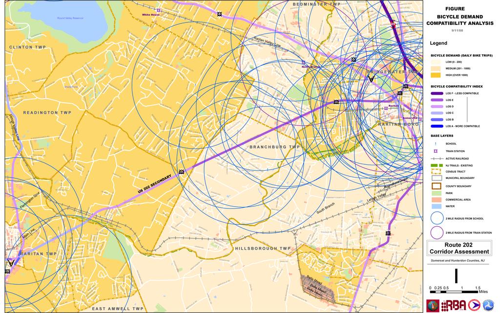
1 6.0 PEDESTRIAN AND BICYCLE FACILITIES 6.1 INTRODUCTION Bicycle and pedestrian travel along and in the vicinity of the corridor is part of the vision of Somerset and Hunterdon counties and the integrated land use and transportation plan for the corridor. Therefore, it is appropriate to include bicycle and pedestrian improvements along the corridor where needed to meet the access and safety needs of the modes. In order to determine the extent of bicycle and pedestrian travel demand in the corridor, several types of analysis have been carried out. These include a Bicycle Travel Demand and Roadway Suitability Assessment and a Pedestrian Travel Demand and Suitability Assessment. These assessments utilized data, modeling tools and modeling results that were developed for the New Jersey Statewide Bicycle and Pedestrian Master Plan, Phase 2. In addition, a field assessment was made of the corridor, focusing on major roadways intersecting Route 202, within the limits of the project. Based on the field assessment and evaluation, a number of specific improvements were recommended, primarily at or in the vicinity of those intersections. 6.2 BICYCLE DEMAND AND SUITABILITY Bicycle Demand Bicycle travel demand is an important consideration in selecting and shaping elements of a corridor improvement plan. A bicycle demand analysis was performed for the Route 202 Corridor from Church Street (M.P.11.93) in Raritan Township, Hunterdon County to First Avenue (M.P. 23.9) in Raritan Borough, Somerset County. This analysis made use of data, modeling tools and modeling results developed for the New Jersey Statewide Bicycle and Pedestrian Master Plan, Phase 2. In assessing bicycle travel demand, the Bicycle Demand Model (BDM) was used. The BDM indicates the number of bicycle trips projected for a given census tract using 2000 Census and Journey to Work data. The findings are presented in ranges of high, medium and low demand; where low demand equals daily bicycle trips, medium demand equals daily bicycle trips, and high demand equals daily bicycle trips. It should be noted that the BDM is a very conservative estimate of demand that accounts for utilitarian trips only and does not consider recreational trips, where increased demand can be anticipated with the implementation of improved facilities. In this model: Total Trips = Utilitarian Trips + (2.0 * Commute Trips). where: Commute Trips = (0.025 * Transit Users) * (0.06 * College Students) + (0.05 * School Children) + (Workers * Bicycle Mode Share). and, Utilitarian Trips = 3.48 * (0.05 * 0.06 * College Students) + (0.05 * School Children) + (Workers * Bicycle Mode Share). All features listed in the above formulas correspond to definitions and field headings in Table 6-1. Page 96
2 Table 6-1 Definitions of Features Used in Bicycle Demand Model Feature Definition 18 Field Header Total Trips The number of work related bicycle trips plus the non-work related TOT_TRP_00 trips in the tract for the year Utilitarian Trips Bicycle trips other than work-related in the tract for the year UTILIT00 Commute Trips Number of work-related trips in the tract for the year COMMUT00 Transit Users Number of people in the tract who used transit to get to work for the year TRANSIT00 College Students College enrollment in the tract for the year ENROLLMENT School Children Workers * Bicycle Mode Share Number of kids between ages 6 and 14 in the tract for the year Number of bicycle-related work trips for the year 2000 (total number of workers by tract* bicycle mode share). AGE_6_14_0 JTW_00 Bicycle Attractor Analysis Another means of assessing demand utilizes trip attractor data developed as part of the New Jersey Statewide Bicycle and Pedestrian Master Plan, Phase 2. For this analysis, bicycle trip attractors (area and point based) were identified and mapped. These included major trip generators such as parks, commercial areas, schools and key destinations. Buffer areas were superimposed over each point-based attractor to highlight potential bicycle travel sheds for bicycle trips to these attractors. The buffer defines a 2-mile radius area for bicycling trips. This distance is based on the 1990 Nationwide Personal Transportation Survey, which identified an average bicycle trip for all purposes at 1.8 mile and 2.1 miles for bicycle commuting (see Bicycle Demand and Suitability Map, Figure 6-1). Results of Bicycle Demand Analysis The results of the bicycle demand analysis are as follows: Bicycle demand by census tract is high or medium throughout the Corridor. There are a number of Commercial establishments located along Route 202, both northbound and southbound. There are numerous commercial establishments clustered at either end of the study corridor in the vicinity of Flemington and the Somerset Regional Center. There are numerous school properties located within a mile of Route 202. There is a Bus Park and Ride located along Route 202 in Branchburg Township;. TransBridge Bus Lines offers bus service to Manhattan from the facility. This analysis suggests that the corridor falls within the "travel shed" of bicycle attractors or exhibits travel demand characteristics suggesting high demand for bicycle travel. As such, bicycle travel is a reasonable and appropriate mode of travel throughout the corridor. 18 Data Dictionary, Final GIS Files, Version 2.1 CD of the NJ Statewide Bicycle and Pedestrian Master Plan, Phase 2, Revised May Page 97
3 61
4 6.2.2 Bicycle Suitability The bicycle suitability analysis uses the Bicycle Compatibility Index (BCI) to provide an indication of the "bicycle suitability" of a given roadway segment, i.e., its perceived ability to accommodate bicycle travel. This is the model used to establish roadway suitability in the New Jersey Statewide Bicycle and Pedestrian Master Plan, Phase 2. The BCI evaluates factors influencing the preferences of bicycle riders to use a particular route alternative based on a bicyclist's perception of a route's safety level. The BCI rates the suitability of a roadway for bicyclists based on lane widths, traffic volumes, speed limits, existence of on-street parking, location within a residential area, and roadway classification. The Level of Service (LOS) for the route is then determined based on the value of the BCI. This is a "link level" analysis, i.e. it does not include an assessment of the overall suitability of a corridor nor does it assess the suitability of intersections in terms of their ability to accommodate bicycle traffic. In this model: BCI = (Bicycle Lane, Shoulder: Yes = 1) (Bicycle Lane or Shoulder Width) (Curb Lane Width) (Curb Lane Volume) (Other Lane Volume) (Speed) (Parking: Yes = 1) (Area: Residential = 1) + Adjustment Factor Lower values indicate a good Level of Service Greater values indicate a poor Level of Service BCI decreases for greater lane widths, shoulders, and location in a residential area (improves LOS) BCI increases with smaller lane and shoulder widths, higher traffic volumes, on-street parking, and higher speed limits (degrades LOS) The BCI has values and corresponding Level of Service (LOS) are shown below: BCI Range LOS 0 to 1.50 A 1.51 to 2.40 B 2.41 to 3.40 C 3.41 to 4.40 D 4.41 to 5.30 E 5.31 & Greater F It should be noted that as part of the New Jersey Statewide Bicycle and Pedestrian Master Plan, Phase 2, bicycle suitability modeling was conducted only for existing Congestion Mitigation System (CMS) roadways. In the study corridor, Route 202 is the only CMS roadway. None of the intersecting roadways between the limits of the project are on the CMS, and bicycle suitability (BCI) was not calculated for them. Results of Bicycle Suitability Analysis The results of the bicycle suitability analysis are as follows: The analysis shows that Route 202 within study corridor limits was identified as providing moderate levels of service for bicycle traffic (see Bicycle Demand & Suitability Map, Figure 6-1). Page 99
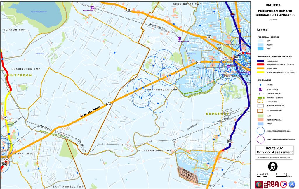
5 Calculation of BCI for Non-CMS Intersection Roadways An interactive spreadsheet tool developed for the New Jersey Statewide Bicycle and Pedestrian Master Plan, Phase 2, was used to hand calculate the BCI of intersecting roadways. The results are shown in Table 6-2, below. The suitability of intersecting roadways is generally moderate or high due primarily to low peak hour traffic volumes and low posted speed limits. Table 6-2 Route 202 Corridor Intersecting Roadways Route 202 East Bound Side Route 202 West Bound Side Intersection # Street Name BCI LOS Suitability BCI LOS Suitability 1 First Ave D Medium 2.16 B High 2 Ortho MacNeil Dr C High 3.57 D Medium 3 Bridgewater T.C. Dr C High 3.42 D Medium 4 Milltown Rd C High 3.25 C High 5 River Rd C High 2.57 C High 6 Robbins Rd C High 2.53 C High 7 Old York Rd C High 3.74 D High 8 West County Dr C High n.a. n.a. n.a. 9 Holland Brook Way 2.09 B High 2.86 C High 10 Whiton Rd C High 2.56 C High 11 Old York Rd C High 3.29 C High 12 Pleasant Run Rd C High 3.48 D Medium 13 Summer Rd D Medium 3.50 D Medium 14 Broad St C High n.a. n.a. n.a. 14 Main St C High n.a. n.a. n.a. 14 River Rd. n.a. n.a. n.a D Medium 15 Railroad Ave D Medium 3.95 D Medium 16 Dory Dilts Rd C High n.a. n.a. n.a. 16 Barley Sheaf 3.00 C High n.a. n.a. n.a. 16 River Rd. n.a. n.a. n.a D Medium 17 Case Blvd C High 2.58 C High 18 Greenwood Pl. n.a. n.a. n.a B High 19 Voorhees Corner Rd B High n.a. n.a. n.a. 19 Church St. n.a. n.a. n.a B High 6.3 PEDESTRIAN DEMAND AND SUITABILITY Pedestrian Demand Pedestrian Demand is also an important consideration in selecting and shaping elements of a pedestrian network. A pedestrian demand analysis was carried out for the Route 202 Corridor by utilizing the Pedestrian Compatibility Index (PCI) results from the New Jersey Statewide Bicycle and Pedestrian Master Plan, Phase 2. The Pedestrian Compatibility Index (despite its name) is a surrogate measure of pedestrian demand that indicates the census tracts with the greatest potential for pedestrian demand. The potential demand is based on variables generally understood to contribute to environments conducive to pedestrian activity, such as density, employment, and transit accessibility. The PCI is a combination of 4 indices (multiplicative) which yields a score for each census tract, normalized to a range of 0-100, with values Low = < 8, Medium = 8-24, and High = Page 100
6 Pedestrian Attractor Analysis As with bicycle travel, utilizing trip attractor data developed as part of the New Jersey Statewide Bicycle and Pedestrian Master Plan, Phase 2, pedestrian trip attractors (area and point based) were identified and mapped. These included major trip generators such as parks, commercial areas, schools and key destinations. Buffer areas were superimposed over each point-based attractor to highlight potential pedestrian travel sheds for walking trips to these attractors. The buffer defines a 1/2-mile radius area for pedestrian trips. This distance is based on the 1990 Nationwide Personal Transportation Survey, which identifies an average walk for all purposes at 0.7 and 0.9 miles for commuting purposes. Results of Pedestrian Demand Analysis The results of the pedestrian demand analysis are as follows: According to the PCI, pedestrian demand by census tract is medium at the eastern end of the corridor and low throughout the remainder of the corridor (see Pedestrian Demand & Crossability Map, Figure 2). Using a buffer radius of a 1/2-mile for pedestrians, the pedestrian "travel shed" defined by the buffered areas around schools and key destinations (such as historical, cultural and recreational features), covers portions of the eastern portion of the study area. According to these criteria, this suggests the pedestrian travel is a reasonable and appropriate model of travel to these destinations throughout this part of the study area (see Pedestrian Demand & Crossability Map, Figure 6-2) Pedestrian Suitability Pedestrian suitability was evaluated utilizing the Pedestrian Crossability Index. This index evaluates roadway crossing opportunities with high, medium or low opportunity levels corresponding to the estimated percentage of time that sufficient gaps in traffic area available to cross safely. The factors incorporated include speed, traffic volume, number of lanes, median width, median type and presence. The crossability index evaluates factors at the link level, not a corridor. Therefore, it does not take into consideration either the distance from the nearest intersection or grade separated crossings, the type of traffic control at nearby intersections or sight distance. It should be noted that pedestrian suitability was conducted only for those roadways that were included in the existing database of information developed for the New Jersey Statewide Bicycle and Pedestrian Master Plan, Phase 2, are included on the CMS. Results of Pedestrian Suitability Analysis Route 202 within the study limits is evaluated as a medium in terms of crossability. Proposed Bikeway Branchburg Township has proposed a Township-wide bicycle and pedestrian system consisting of a network of shared use paths and designated on-road facilities. Several links of the network are proposed to intersect with Route 202. These proposed crossings are located in the vicinity of Whiton Road, Club Way, and Dover Road. Specific crossing treatments, at grade or grade separated, have not been specified. Page 101

7 2


8 6.4 RECOMMENDATIONS Based on the results of the Demand and Suitability Analyses and field assessments, a number of specific improvements, primarily pedestrian improvements are recommended throughout the corridor. These are identified by intersection in the Implementation Matrix, shown in Section 8.0, and are described in more detail in the Technical Appendix. Pedestrian scale lighting is recommended to be installed along all existing or proposed sidewalk segments and waiting areas adjacent to the intersections. Roadway lighting is recommended to be installed to illuminate the crosswalk areas. In addition to the pedestrian accommodations, it is also recommended that full width shoulders be maintained on Route 202 throughout the length of the project to enable the roadway to maintain bicycle compatibility. This requires signing at the approach to a number of intersections, as noted. Presently, the only intersecting roadway that included a designated bikeway is intersection of Church Street/Voorhees Corner Road. No specific bicycle treatments are recommended for intersecting roads. Installing specific bicycle treatments on intersecting roadways should depend on whether one of those roadways is identified in future circulation plans by the counties and municipalities along Route 202 as (incorporating) a designated bikeway. Figure 6-3 Typical Curb Ramp Design Treatments Curb ramp example Page 103
ADOT Statewide Bicycle and Pedestrian Program Summary of Phase IV Activities APPENDIX B PEDESTRIAN DEMAND INDEX
 ADOT Statewide Bicycle and Pedestrian Program Summary of Activities APPENDIX B PEDESTRIAN DEMAND INDEX May 24, 2009 Pedestrian Demand Index for State Highway Facilities Revised: May 29, 2007 Introduction
Welcome and Introductions Overview of the Study to Date Community Involvement Intersection Improvement Concepts Bike-Ped Recommendations ITS
 Welcome and Introductions Overview of the Study to Date Community Involvement Intersection Improvement Concepts Bike-Ped Recommendations ITS Recommendations Transit Recommendations Next Steps Inventoried
Lee s Summit Road Improvement Study Public Open House June 7, 2007 Summary of Comment Card Responses
 Lee s Summit Road Improvement Study Public Open House June 7, 2007 Summary of Comment Card Responses Introduction At the Lee s Summit Road Improvement Study Public Open House held Thursday, June 7, 2007
SECTION 1 - TRAFFIC PLANNING
 SECTION 1 - TRAFFIC PLANNING 1.1 TRAFFIC OPERATIONS 1.1.1 Roadway Functional Classification The Multnomah County Comprehensive Framework Plan s Policy 34: Trafficways and the Functional Classification
Chapter 13 ORANGE COVE
 Chapter 13 ORANGE COVE This chapter describes the current status and future plans for biking and walking in the City of Orange Cove. RELATIONSHIP TO CITY PLANS AND POLICIES The Orange Cove General Plan
MEMORANDUM. Charlotte Fleetwood, Transportation Planner
 MEMORANDUM Date: Updated August 22, 2017 To: Organization: Charlotte Fleetwood, Transportation Planner Boston Transportation Department From: Jason DeGray, P.E., PTOE, Regional Director of Engineering
APPENDIX A: Complete Streets Checklist DRAFT NOVEMBER 2016
 APPENDIX A: Complete Streets Checklist DRAFT NOVEMBER 2016 Complete Streets Checklist MetroPlan Orlando s Complete Streets Checklist is an internal planning tool for staff to further implementation of
5. RUNNINGWAY GUIDELINES
 5. RUNNINGWAY GUIDELINES These guidelines should be considered collectively when making runningway decisions. A runningway is the linear component of the transit system that forms the right-of-way reserved
2.0 Existing Conditions
 20 2.0 Existing Conditions 2.1 Land Use, Future Growth Patterns, Physical Barriers Geographic Overview Sutter County s land use pattern is characterized by extensive agricultural areas, significant natural
Item to be Addressed Checklist Consideration YES NO N/A Required Description Complete Streets Guidelines
 Passaic County Complete Streets Checklist - Concept Development Project Name Item to be Addressed Checklist Consideration YES NO N/A Required Description Complete Streets Guidelines Existing Plans Have
GIS Based Data Collection / Network Planning On a City Scale. Healthy Communities Active Transportation Workshop, Cleveland, Ohio May 10, 2011
 The Purpose of GIS Based Network Planning GIS Based Data Collection / Network Planning Healthy Communities Active Transportation Conference Tuesday, May 10, 2011 10:00 AM Norman Cox, LLA, ASLA. Ann Arbor,
Chapter 14 PARLIER RELATIONSHIP TO CITY PLANS AND POLICIES. Recommendations to Improve Pedestrian Safety in the City of Parlier (2014)
") Chapter 14 PARLIER This chapter describes the current status and future plans for biking and walking in the City of Parlier. RELATIONSHIP TO CITY PLANS AND POLICIES The Parlier General Plan is the primary
Chapter 14 PARLIER This chapter describes the current status and future plans for biking and walking in the City of Parlier. RELATIONSHIP TO CITY PLANS AND POLICIES The Parlier General Plan is the primary
Planning Guidance in the 2012 AASHTO Bike Guide
 Planning Guidance in the 2012 AASHTO Bike Guide Presentation by: RJ Eldridge Peter Lagerwey August 22, 2012 WEBINAR 2: PLANNING GUIDANCE IN THE 2012 AASHTO BIKE GUIDE Today s Webinar Significant Updates
NJDOT Complete Streets Checklist
 Background The New Jersey Department of Transportation s Complete Streets Policy promotes a comprehensive, integrated, connected multi-modal network by providing connections to bicycling and walking trip
Complete Street Analysis of a Road Diet: Orange Grove Boulevard, Pasadena, CA
 Complete Street Analysis of a Road Diet: Orange Grove Boulevard, Pasadena, CA Aaron Elias, Bill Cisco Abstract As part of evaluating the feasibility of a road diet on Orange Grove Boulevard in Pasadena,
TRAFFIC IMPACT STUDY CRITERIA
 Chapter 6 - TRAFFIC IMPACT STUDY CRITERIA 6.1 GENERAL PROVISIONS 6.1.1. Purpose: The purpose of this document is to outline a standard format for preparing a traffic impact study in the City of Steamboat
Chapter 5 Future Transportation
 Chapter 5 Future Transportation The Future Land Use Plan identifies the desired land use designations. The land uses desired for Crozet depend, in large part, on the success of the transportation system,
Bellevue Downtown Association Downtown Bike Series
 Bellevue Downtown Association Downtown Bike Series Meeting 2 Franz Loewenherz Andreas Piller Kyle Potuzak Chris Long October 26, 2017 Today s Agenda: 1) Meeting Purpose 2) 9/28 Meeting Recap 3) Candidate
Bicycle and Pedestrian Connectivity Study. Old Colony Planning Council
 Bicycle and Pedestrian Connectivity Study Old Colony Planning Council Outline Why consider bike/peds in road designs? Why are measures needed? Connecting Land Use with Transportation Evaluation Tools:
APPENDIX E: Transportation Technical Report
 New Jersey Pennsylvania Lackawanna Cut-Off Passenger Rail Service Reston Project Environmental Assessment APPENDIX E: Transportation Technical Report E.1 Introduction As part of the overall environmental
Bridgewater Complete Streets Prioritization Plan and Pedestrian Safety Assessment
 Bridgewater Complete Streets Prioritization Plan and Pedestrian Safety Assessment Presented by Luciano Rabito Manager of Complete Streets Presented to Bridgewater, MA Wednesday, April 26, 2017 6:30 P.M.
PEDESTRIAN ACTION PLAN
 ATTACHMENT 2 CITY OF SANTA MONICA PEDESTRIAN ACTION PLAN CITY OF SANTA MONICA PEDESTRIAN ACTION PLAN This page intentionally left blank EXECUTIVE SUMMARY CHAPTER 1 EXECUTIVE SUMMARY Setting the Stage
SANTA CLARA COUNTYWIDE BICYCLE PLAN August 2008
 SANTA CLARA COUNTYWIDE BICYCLE PLAN August 2008 To assist VTA and Member Agencies in the planning, development and programming of bicycle improvements in Santa Clara County. Vision Statement To establish,
City of Charlottesville Bicycle and Pedestrian Master Plan Update
 City of Charlottesville Bicycle and Pedestrian Master Plan Update September 17, 2014 I. Welcome and meeting overview II. Project status update III. Network overview IV. Break-out groups Pedestrian Network
TRANSPORTATION & MOBILITY
 TRANSPORTATION & MOBILITY ROADWAY SYSTEM There are approximately 40 miles of roadways in Manitou Springs. For planning purposes, roadways are typically assigned a functional classification which defines
CITY OF COCOA BEACH 2025 COMPREHENSIVE PLAN. Section VIII Mobility Element Goals, Objectives, and Policies
 CITY OF COCOA BEACH 2025 COMPREHENSIVE PLAN Section VIII Mobility Element Goals, Objectives, and Policies Adopted August 6, 2015 by Ordinance No. 1591 VIII MOBILITY ELEMENT Table of Contents Page Number
Recommended Roadway Plan Section 2 - Land Development and Roadway Access
 Recommended Roadway Plan Section 2 - Land Development and Roadway Access SECTION 2 Land Development and Roadway Access 2.1 Land Use and Access Management The Federal Highway Administration (FHWA) defines
Implementing Complete Streets in Ottawa. Project Delivery Process and Tools Complete Streets Forum 2015 October 1, 2015
 Implementing Complete Streets in Ottawa October 1, 2015 The Essentials Complete Streets Implementation Framework will become part of the routine delivery of City transportation projects Approach uses every
CONNECTING PEOPLE TO PLACES
 CONNECTING PEOPLE TO PLACES 82 EAST BENCH MASTER PLAN 07 Introduction The East Bench transportation system is a collection of slow moving, treelined residential streets and major arteries that are the
City of Seattle Edward B. Murray, Mayor
 City of Seattle Edward B. Murray, Mayor Department of Transportation Scott Kubly, Director Eastlake Community Council 117 E Louisa St. #1 Seattle, WA 98102-3278 January 28, 2016 RE: Roosevelt to Downtown
Waterford Lakes Small Area Study
 Waterford Lakes Small Area Study Existing Traffic Conditions PREPARED FOR: ORANGE COUNTY PUBLIC WORKS DEPARTMENT TRAFFIC ENGINEERING DIVISION ORLANDO, FLORIDA PREPARED WITH: INWOOD CONSULTING ENGINEERS
Southwest Bus Rapid Transit (SW BRT) Functional Planning Study - Executive Summary January 19 LPT ATTACHMENT 2.
 Functional Planning Study - Executive Summary January 19 LPT ATTACHMENT 2.") Southwest Bus Rapid Transit (SW BRT) Functional Planning Study - Executive Summary 2011 January 19 1 of 19 Introduction This executive summary presents the results of the Southwest Bus Rapid Transit (SW
Southwest Bus Rapid Transit (SW BRT) Functional Planning Study - Executive Summary 2011 January 19 1 of 19 Introduction This executive summary presents the results of the Southwest Bus Rapid Transit (SW
Appendix 3 Roadway and Bike/Ped Design Standards
 Appendix 3 Roadway and Bike/Ped Design Standards OTO Transportation Plan 2040 4/20/2017 Page A3-1 Adopted Standards The adopted OTO Design Standards and Major Thoroughfare Plan are contained herein.
Pedestrian Project List and Prioritization
 To: Kyle Wagenschutz, City of Memphis CC: From: Anne Conlon and John Cock, Alta Planning + Design Date: December, 2014 Re: Project List Development (Task 3.1-3.2) and Project List Prioritization (Task
TRAFFIC IMPACT ANALYSIS
 TRAFFIC IMPACT ANALYSIS FOR THE CHAMPAIGN UNIT#4 SCHOOL DISTRICT PROPOSED HIGH SCHOOL (SPALDING PARK SITE) IN THE CITY OF CHAMPAIGN Final Report Champaign Urbana Urbanized Area Transportation Study 6/24/2014
C C C
 C-012-001 Thank you for your support for the creation of new public space and nonmotorized access between downtown and the waterfront through the Overlook Walk, the East-West Connections, and the Promenade.
Anne Arundel County BICYCLE, PEDESTRIAN, TRANSIT ASSESSMENT GUIDELINES
 Anne Arundel County BICYCLE, PEDESTRIAN, TRANSIT ASSESSMENT GUIDELINES December 2018 TABLE OF CONTENTS I. Executive Summary 3 II. When Is A Bicycle Pedestrian Transit Assessment (BPTA) Required? 4 III.
TRAFFIC ACTION PLAN. Laurie Meadows Neighborhood CITY OF SAN MATEO
 TRAFFIC ACTION PLAN Laurie Meadows Neighborhood CITY OF SAN MATEO Draft January 2017 Table of Contents Introduction... 2 The Traffic Forum Process... 5 Neighborhood Traffic Issues... 7 Neighborhood Recommendations
APPENDIX A BICYCLE, PEDESTRIAN, AND TRANSIT ASSESSMENT WORKSHEET. B. Subdivision/Site Development Plan/Grading Permit Name and Number:
 APPENDIX A BICYCLE, PEDESTRIAN, AND TRANSIT ASSESSMENT WORKSHEET I. GENERAL INFORMATION A. Project name: B. Subdivision/Site Development Plan/Grading Permit Name and Number: C. Project address: D. Project
Donahue Drive Corridor Traffic Operational Evaluation
 Donahue Drive Corridor Traffic Operational Evaluation PREPARED FOR: THE CITY OF AUBURN PREPARED BY: JANUARY 2007 Donahue Drive Corridor Study--Auburn, Alabama TABLE OF CONTENTS Introduction... 1 Background
I-105 Corridor Sustainability Study (CSS)
") I-105 Corridor Sustainability Study (CSS) Metro Streets and Freeways Subcommittee March 21, 2019 Gary Hamrick Cambridge Systematics, Inc. I-105 CSS Project History & Background Funded by Caltrans Sustainable
I-105 Corridor Sustainability Study (CSS) Metro Streets and Freeways Subcommittee March 21, 2019 Gary Hamrick Cambridge Systematics, Inc. I-105 CSS Project History & Background Funded by Caltrans Sustainable
Bicycle Facilities Planning
 Bicycle Facilities Planning Overview Types of Cyclists Purpose for Riding Types of Facilities Bike Lanes Bicycle Boulevards Cycle Tracks Intersections Signals Signing and Marking Discussion Types of Bicyclists
CONTEXT SENSITIVE STREETS STANDARDS COMMITTEE
 CONTEXT SENSITIVE STREETS STANDARDS COMMITTEE February 23, 2015 Prepared by: Denise Chaplick, AICP City Jacksonville Bicycle and Pedestrian Coordinator Source: NCDOT Complete Streets Planning and Design
US 41 COMPLETE STREETS CORRIDOR PLANNING STUDY from University Parkway to Whitfield Avenue
 41 US 41 COMPLETE STREETS CORRIDOR PLANNING STUDY from University Parkway to Whitfield Avenue EXECUTIVE SUMMARY DRAFT FEBRUARY 2019 Project Overview The US 41 Complete Streets Corridor Planning Study,
Rochester Downtown Bicycle Study 2009
 Rochester Downtown Bicycle Study 2009 Relationship of ROCOG Long Range Transportation Plan to Rochester Comprehensive Plan Regional Long Range Transportation Plan (LRTP) is prepared under the auspices
Duwamish Way-finding and CTR Report
 V. North Tukwila When the North Tukwila Manufacturing and Industrial Center was designated in 1992 as part of the region s land use and transportation plan, the plan called for the area to set a light-rail
Transportation Planning Division
 Transportation Planning Division Presentation Outline Study Tasks Recap of Previous Meetings Data Collected Focus Areas within Study Limits Design Principles Tool Box Recommended Concepts Schedule Moving
Parks Highway: MP Lucus Road to Big Lake Road
 2 Purpose and Need 2.1 Corridor History The Parks Highway is a 324-mile long Rural Interstate Highway that extends from its intersection with the Glenn Highway north to Fairbanks, Alaska. The Parks Highway
Defining Purpose and Need
 Advanced Design Flexibility Pilot Workshop Session 4 Jack Broz, PE, HR Green May 5-6, 2010 Defining Purpose and Need In your agency s project development process, when do design engineers typically get
Completing the Street: Denning Drive
 Completing the Street: Denning Drive Public Workshop and Walking Audit Winter Park Civic Center May 12, 2016 Completing the Street What Makes This a Complete Street? Completing the Street Complete Streets
4. ENVIRONMENTAL IMPACT ANALYSIS 9. TRANSPORTATION AND TRAFFIC
 4. ENVIRONMENTAL IMPACT ANALYSIS 9. TRANSPORTATION AND TRAFFIC 4.9.1 INTRODUCTION The following section addresses the Proposed Project s impact on transportation and traffic based on the Traffic Study
TRAFFIC STUDY GUIDELINES Clarksville Street Department
 TRAFFIC STUDY GUIDELINES Clarksville Street Department 9/1/2009 Introduction Traffic studies are used to help the city determine potential impacts to the operation of the surrounding roadway network. Two
Corpus Christi Metropolitan Transportation Plan Fiscal Year Introduction:
 Introduction: The Safe, Accountable, Flexible, Efficient Transportation Equity Act: A Legacy for Users (SAFETEA-LU) has continued the efforts started through the Intermodal Surface Transportation Efficiency
Comments EXECUTIVE SUMMARY
 Comments 1. Under any Alternatives, MCDOT should provide better at-grade pedestrian crossing of Georgia Avenue and Forest Glen Road, including improved crosswalks with wider medians and adequate signal
New Seward and 36 th Avenue Intersection Conceptual Design
 University of Alaska Anchorage New Seward and 36 th Avenue Intersection Conceptual Design Prepared By: Zaid S. Hussein Dana Menendez Galen Jones Civil Engineering Department Prof. Osama Abaza CE A404 Highway
City of Gainesville Transportation/Roadway Needs PROJECT SUMMARY
 A1 Roadway Resurfacing $23,846,000 TYPE: Preservation of existing system Roadway resurfacing A2 Signal Replacement $6,000,000 TYPE: Preservation of existing system Replace traffic signals. B1 W 6th St
Appendix T CCMP TRAIL TRAFFIC & TRANSPORTATION DESIGN STANDARD
 Appendix T CCMP 3.3.4 TRAIL TRAFFIC & TRANSPORTATION DESIGN STANDARD 3.3.4 Trail Traffic and Transportation Design Multi-use trails have certain design standards, which vary depending on the agency that
TRANSPORTATION ANALYSIS REPORT US Route 6 Huron, Erie County, Ohio
 TRANSPORTATION ANALYSIS REPORT US Route 6 Huron, Erie County, Ohio December 12, 2012 Prepared for: The City of Huron 417 Main Huron, OH 44839 Providing Practical Experience Technical Excellence and Client
Dr. M.L. King, Jr. Street North Complete Streets Resurfacing Opportunities HOUSING, LAND USE, AND TRANSPORTATION COMMITTEE MARCH 22, 2018
 Dr. M.L. King, Jr. Street North Complete Streets Resurfacing Opportunities HOUSING, LAND USE, AND TRANSPORTATION COMMITTEE MARCH 22, 2018 What s Happening The City plans to mill and resurface Dr. M.L.
2010 Pedestrian and Bicyclist Special Districts Study Update
 2010 Pedestrian and Bicyclist Special Districts Study Update Pedestrian and Bicyclist Special Districts Program Overview H-GAC s Special Districts Program aims to provide strategic investments in pedestrian
ALLEY 24 TRAFFIC STUDY
 ALLEY 24 TRAFFIC STUDY in City of Frostburg, Maryland January 2013 3566 Teays Valley Road Hurricane, WV Office: (304) 397-5508 www.denniscorporation.com Alley 24 Traffic Study January 2013 Frostburg, Maryland
Exhibit 1 PLANNING COMMISSION AGENDA ITEM
 Exhibit 1 PLANNING COMMISSION AGENDA ITEM Project Name: Grand Junction Circulation Plan Grand Junction Complete Streets Policy Applicant: City of Grand Junction Representative: David Thornton Address:
TABLE OF CONTENTS. Executive Summary
 Executive Summary Background... ES-1 Pedestrian Network... ES-2 Bikeway Network... ES-2 Collision History... ES-2 Public Input... ES-4 Conclusions and Recommendations... ES-4 1. Introduction and Setting
Board-Approved Funding Awards for Cycle 4 Active Transportation Grant Program Projects (in Order of Project Rankings) Approved on
 Approved on") CAPITAL Large Category Projects Board-Approved Funding Awards for Cycle 4 Active Transportation Grant Program Projects (in Order of Project Rankings) Approved on 07-27-18 1 La Mesa University Ave Pedestrian
CAPITAL Large Category Projects Board-Approved Funding Awards for Cycle 4 Active Transportation Grant Program Projects (in Order of Project Rankings) Approved on 07-27-18 1 La Mesa University Ave Pedestrian
Lyons Avenue/Dockweiler Road Extension Project Draft Environmental Impact Report. Appendix I Traffic Impact Study
 Lyons Avenue/Dockweiler Road Extension Project Draft Environmental Impact Report Appendix I Traffic Impact Study Street 0 80-1947 500.4501 RITA ld Court 0 91355-1096 400.7401 LA n Avenue 0 590-3745 300-9301
GIS Based Non-Motorized Transportation Planning APA Ohio Statewide Planning Conference. GIS Assisted Non-Motorized Transportation Planning
 The Purpose of GIS Assisted Network GIS Assisted Non-Motorized Transportation 2011 APA Ohio Statewide Conference Friday, 10:45 AM to Noon Focus on near-term projects wwwgreenwaycollabcom The purpose of
CITY OF ALPHARETTA DOWNTOWN MASTER PLAN TRAFFIC EVALUATION
 CITY OF ALPHARETTA DOWNTOWN MASTER PLAN TRAFFIC EVALUATION June 2015 CITY OF ALPHARETTA DOWNTOWN MASTER PLAN TRAFFIC EVALUATION Introduction The Alpharetta Downtown Master Plan was developed in the fall
MASER ASSOCIATES. Engineers Planners Surveyors TRAFFIC IMPACT ANALYSIS FOR PROPOSED RESIDENTIAL MULTI-FAMILY SEA GULL VILLAGE TOWNSHIP OF COLTS NECK
 000 MASER ASSOCIATES Engineers Planners Surveyors TRAFFIC IMPACT ANALYSIS FOR PROPOSED RESIDENTIAL MULTI-FAMILY DEVELOPMENT SEA GULL VILLAGE TOWNSHIP OF COLTS NECK MONMOUTH COUNTY Prepared By: Richard
NM-POLICY 1: Improve service levels, participation, and options for non-motorized transportation modes throughout the County.
 Transportation PRINCE WILLIAM COUNTY 2008 COMPREHENSIVE PLAN NON-MOTORIZED PLAN CONTENTS Goals, Policies, and Action Strategies Table 4 (Bike Facility Classifications and Descriptions) Table 5 (Bike Facility
Multimodal Analysis in the 2010 Highway Capacity Manual
 Multimodal Analysis in the 2010 Highway Capacity Manual It s not just cars anymore! Jamie Parks, AICP HCAT Conference May 9-10, 2011 Multimodal LOS in the 2010 HCM History and background Overview of methods
Phone: Fax: Project Reference No. (to be filled out by MassHighway):
:") Massachusetts Highway Department District 3 Project Need Form (PNF) This form is intended to provide preliminary information about the proposed project. It is not expected that all information that is
Massachusetts Highway Department District 3 Project Need Form (PNF) This form is intended to provide preliminary information about the proposed project. It is not expected that all information that is
Hennepin County Pedestrian Plan Public Comment Report
 Hennepin County Pedestrian Plan Public Comment Report On May 31, 2013, the draft Hennepin County Pedestrian Plan was released for a 45-day public comment period ending July 15, 2013. The county received
Non-Motorized Transportation 7-1
 Non-Motorized Transportation 7-1 Transportation facilities no longer mean just accommodating a vehicle powered by a combustion engine. Pedestrian and non-motorized facilities are important modes of travel
SETTINGS AND OPPORTUNITIES MOBILITY & ACCESS
 7 mobility & access how do people use el camino what is it like to drive on el camino/to park along el camino what is the pedestrian experience like what is the role of transit along the corridor what
Omaha s Complete Streets Policy
 Omaha s Complete Streets Policy (Adopted August 2015) VISION To create great places and enhance our quality of life, the City of Omaha will provide safe, accessible streets for all users. Complete Streets
Off-road Trails. Guidance
 Off-road Trails Off-road trails are shared use paths located on an independent alignment that provide two-way travel for people walking, bicycling, and other non-motorized users. Trails specifically along
Executive Summary Route 30 Corridor Master Plan
 Route Corridor Master Plan Project Overview The Route Corridor Master Plan is a coordinated multimodal transportation and land use plan for the entire stretch of Route through East Whiteland Township,
WELCOME. Stakeholder Involvement Group Meeting #2 Round Lake Public Works October 24, 2018
 WELCOME Stakeholder Involvement Group Meeting #2 Round Lake Public Works October 24, 2018 MEETING AGENDA 1. Welcome and Introductions 2. Study Progress Update 3. Problem Statement 4. Technical Analysis
SECTION V - CIRCULATION PLAN
 - CIRCULATION PLAN 1 2 - CIRCULATION PLAN ELEMENT INTRODUCTION As a community that is essentially fully-developed, Livingston s transportation improvement opportunities are limited. The primary mode of
SAN FRANCISCO MUNICIPAL TRANSPORTATION AGENCY
 THIS PRINT COVERS CALENDAR ITEM NO. : 11 DIVISION: Sustainable Streets BRIEF DESCRIPTION: SAN FRANCISCO MUNICIPAL TRANSPORTATION AGENCY Approving traffic modifications on Twin Peaks Boulevard between Christmas
Long Island Rail Road Expansion Project Floral Park to Hicksville
 Long Island Rail Road Expansion Project Floral Park to Hicksville Final Environmental Impact Statement Appendix 1-D Complete Streets Policy Checklist April 2017 0902ML PIN: Project Location: 18A-4 Floral
Morristown, NJ Complete Streets Policy
 Morristown, NJ Complete Streets Policy Introduction A Complete Street is defined as a means to provide safe access for all users by designing and operating a comprehensive, integrated, connected multi-modal
2014/2015 BIKE ROUTE PLAN 83 AVENUE PROTECTED BIKE LANE
 About the Project The City of Edmonton is planning a major bike route on the southside of Edmonton. The Strathcona Bike Route will connect the communities of Strathcona, Garneau and the University area,
Moving Towards Complete Streets MMLOS Applications
 Moving Towards Complete Streets MMLOS Applications Transportation Education Series May 18 th, 2012 It s not just for cars! Presentation Overview The Complete Streets Movement What is Multi-Modal Level
EXECUTIVE SUMMARY... vii 1 STUDY OVERVIEW Study Scope Study Area Study Objectives
 Contents EXECUTIVE SUMMARY... vii 1 STUDY OVERVIEW... 1-1 1.1 Study Scope... 1-1 1.2 Study Area... 1-1 1.3 Study Objectives... 1-3 2 EXISTING CONDITIONS... 2-1 2.1 Existing Freeway Conditions... 2-4 2.1.1
Welcome. If you have any questions or comments on the project, please contact:
 Welcome This drop-in public open house is intended to provide information about the Bay Street bike lanes project. This project proposes a dedicated cycling facility along Bay Street between Aberdeen Avenue
Clackamas County Comprehensive Plan
 ROADWAYS The County s road system permits the movement of goods and people between communities and regions, using any of a variety of modes of travel. Roads provide access to virtually all property. They
City of Davis East Covell Corridor Plan
 Community Open House #2 January 22, 2014 6:00 8:00 p.m. Veterans Memorial Center, Club Room City of Davis Introduction The (ECCP) is a taking a comprehensive look at the existing transportation systems
Cycle Track Design Best Practices Cycle Track Sections
 Design Best Practices Sections It is along street segments where the separation and protection methods of cycle tracks offer more comfort than conventional bicycle lanes, and are more attractive to a wide
Chapter 4 Traffic Analysis
 Chapter 4 Traffic Analysis PURPOSE The traffic analysis component of the K-68 Corridor Management Plan incorporates information on the existing transportation network, such as traffic volumes and intersection
BETHEL ROAD AND SEDGWICK ROAD CORRIDOR STUDY
 DRAFT PLAN City Council Meeting August 14, 2017 STUDY AREA Sedgwick Corridor State Route 160, principal arterial with Class 3 access management designation, commuter and freight route, connection to SR
Figure 4-10: Pedestrian Improvements Types of Potential Station Area Improvements - Place-Making Improvements
 INCORPORATE FEATURE PAVIN IN CROSSWALK AND INTERSECTION FIELDS Identifies high-priority pedestrian areas and create a station identity through colorful and interesting patterns ADD CURB EXTENSIONS Extending
AMATS Complete Streets Policy
 AMATS Complete Streets Policy Table of Contents: Section 1. Definition of Complete Streets Section 2. Principles of Complete Streets Section 3. Complete Streets Policy Section 4. Consistency Section 5.
Central Jersey Transportation Forum. March 2007
 Central Jersey Transportation Forum March 2007 Feasibility Analysis of BRT on Dinky Right of Way from Princeton Station to Alexander Rd. in West Windsor (west of Rt. 1) Study spurred by Princeton University's
Subject: Solberg Avenue / I-229 Grade Separation: Traffic Analysis
 MEMORANDUM Transportation Bill Troe, AICP Jason Carbee, AICP 12120 Shamrock Plaza Suite 300 Omaha, NE 68154 (402) 334-8181 (402) 334-1984 (Fax) To: Project File Date: Subject: Solberg Avenue / I-229 Grade
Safe Routes to School Travel Plan 2011
 Safe Routes to School Travel Plan 2011 Barley Sheaf Elementary School Barley Sheaf School 80 Barley Sheaf Road Flemington, NJ 08822 Grades: K-4 Introduction Barley Sheaf School is a K-4 elementary school
Traffic Impact Analysis (TIA) Process and Procedures Manual. September 2017
 Process and Procedures Manual. September 2017") Traffic Impact Analysis (TIA) Process and Procedures Manual Post Office Box 664 101 Huntersville-Concord Road Huntersville, NC 28070 Phone 704-766-2220 Fax 704-992-5528 www.huntersville.org (c) 2017, Town
Traffic Impact Analysis (TIA) Process and Procedures Manual Post Office Box 664 101 Huntersville-Concord Road Huntersville, NC 28070 Phone 704-766-2220 Fax 704-992-5528 www.huntersville.org (c) 2017, Town
This page intentionally left blank.
 This page intentionally left blank. COMMUNITY Glenpool Community Overview Glenpool Glenpool is a city of nearly 12,000 residents located in Tulsa County southwest of Tulsa and Jenks. The city is growing
Overview. Illinois Bike Summit IDOT Complete Streets Policy Presentation. What is a Complete Street? And why build them? And why build them?
 Overview Illinois Bike Summit IDOT Complete Streets Policy Presentation Aren Kriks, P.E. District One Bicycle Coordinator and Bureau of Programming Project Engineer History of Complete Streets IDOT Policy
Sixth Line Development - Transit Facilities Plan
 Memorandum Date: November 13, 2012 To: From: c.c. Subject: Rob Freeman (Freeman Planning) Kevin Phillips Sixth Line Development - Transit Facilities Plan 33016631 This memo was prepared to review the transit