State Road 54/56 Tampa Bay s Northern Loop. The Managed Lane Solution Linking I-75 to the Suncoast Parkway
|
|
|
- Leo Thomas
- 5 years ago
- Views:
Transcription

1 State Road 54/56 Tampa Bay s Northern Loop The Managed Lane Solution Linking I-75 to the Suncoast Parkway


2 SUNCOAST PARKWAY Both I 75 and the Suncoast Parkway are planning, or in the process of constructing, Managed Lanes to accommodate North South travel INTERSTATE 75 SR 54 is needed to complete the Managed Lane Concept Connecting I 75 with the Suncoast Parkway

3 LRTP 2035 Travel Demand Analysis 12 to 20 Lanes Required
 US 19")
4 LRTP 2035 Cost Affordable Plan Managed Lanes (improvements to be determined by FDOT Study) US 19 US 301


5 What are the Alternatives? 19 Lanes US Highway 19 Construction

6 SR 54/56 Managed Lanes History and Study Timeline TBARTA Master Plan Pasco LRTP FDOT/TBARTA Multi-Modal Transit & Managed Lanes Feasibility Evaluation US 19 to Bruce B. Downs CCC/TBARTA Regional Priorities Listed Project Underway Pasco/FDOT Tolling Feasibility Study Underway LRTP
7 All possible alternative solutions been fully explored All at-grade and alternative elevated solutions have been thoroughly evaluated. 18 Initial Alternatives were studied via the TBARTA/FDOT Multi- Modal Transit and Managed Lanes Feasibility Evaluation. The Alternatives eliminated due to not being practical: 1. All Light Rail Transit (LRT) Alternatives 2. All At-Grade Managed Lane Alternatives 3. All At-Grade Bus Rapid Transit (BRT) Alternatives 6 Alternatives moved forward for additional evaluation with the Express Bus/Managed Lanes 4 Lanes Elevated alternative selected as the Recommended Alternative.
8 18 Initial Alternatives Evaluated (TBARTA/FDOT Multi-Modal Transit and Managed Lanes Feasibility Evaluation) BRT on Dedicated Guideway without Managed Lanes BRT on Dedicated Guideway with Managed Lanes Express Bus in General Use Lanes with Queue Jumps LRT on Dedicated Guideway With Managed Lanes Express Bus in Managed Lanes (At Grade) LRT on Dedicated Guideway Without Managed Lanes Express Bus in Managed Lanes (Elevated) BRT Light in General Use Lanes with Queue Jumps
9 12 Alternatives Eliminated All Light Rail Transit (LRT) Alternatives Insufficient ridership ( 8 Stations = 1,400 per day) All At Grade Managed Lanes Alternatives Cross access is severely restricted Negative Impacts on Businesses Much lower traffic volumes All At Grade Bus Rapid Transit (BRT) Alternatives Cross access is severely restricted Negative Impacts on Businesses Insufficient Ridership (1,190 to 4,000 per day)
10 At-Grade (both Bus & Managed Lane) Problems Affected Element Number Number of Existing Traffic Signals Removed 10 Number of Existing Emergency Signals Removed 2 Number of Existing Directional Median Openings Removed 68 Number of Existing Full Access Median Openings Removed 38
11 6 Alternatives that were further studied Feasible Alternative Ridership Managed Lane Toll Amount Managed Lane AADT Range General Purpose Lane AADT Range 1: BRT Light in General Use Lanes w/ Queue Jumps 940 2: Express Bus in General Use Lanes w/ Queue Jumps 940 4: Express Bus/Managed Lanes 2 Lanes Elevated - 6: Express Bus/Managed Lanes 4 Lanes Elevated - 8B: BRT on Dedicated Guideway Elevated in the Median 1,190-4,000 8D: BRT on Dedicated Guideway Elevated on the Shoulder 1,190-4,000 Low N/A 50, ,000 High N/A 50, ,000 Low N/A 50, ,000 High N/A 50, ,000 Low 18,200 51,300 43,000 90,000 High 6,800 45,000 50,000 93,000 Low 20,300 86,000 39,000 80,000 High 8,200 67,900 50,000 87,000 Low N/A 50, ,000 High N/A 50, ,000 Low N/A 50, ,000 High N/A 50, ,000
12 Alternatives Evaluation - SR 54 From I 75 to US (pm Peak, West Bound Direction) Feasible Alternative Congested Speed Travel Time No Build Alternative 6 (4 Lane Tolled Elevated Managed Lanes) At Grade 9 mph 37 min Elevated N/A N/A At Grade 20 mph 16 min Elevated 44 mph 7 min Alternative 1- BRT Light Similar to No Build Similar to No Build Alternative 2- Express Bus Similar to No Build Similar to No Build Alternative 4 2 Lane Tolled Elevated Managed Lanes Similar to Alternative 6 Similar to Alternative 6 8B: BRT on Dedicated Guideway Elevated in the Median Similar to No Build Similar to No Build 8D: BRT on Dedicated Guideway Elevated on the Shoulder Similar to No Build Similar to No Build
13 Alternatives Evaluation - SR 54 From US 41 to Suncoast Parkway 2035(pm Peak, West Bound Direction) Feasible Alternative Congested Speed Travel Time No Build At Grade 13 mph 23 min Elevated N/A N/A Alternative 6 (4 Lane Tolled Elevated Managed Lanes) At Grade 25 mph 12 min Elevated 43 mph 7 min Alternative 1- BRT Light Similar to No Build Similar to No Build Alternative 2- Express Bus Similar to No Build Similar to No Build Alternative 4 2 Lane Tolled Elevated Managed Lanes Similar to Alternative 6 Similar to Alternative 6 8B: BRT on Dedicated Guideway Elevated in the Median Similar to No Build Similar to No Build 8D: BRT on Dedicated Guideway Elevated on the Shoulder Similar to No Build Similar to No Build

14 Alternatives Evaluation Matrix Feasible Alternative RECOMMENDED ALTERNATIVE EVALUATION FACTORS 1: BRT Light in General Use w/qj s 2: Express Bus in General Use w/qj 4: Express Bus/Managed Lanes, 2 Lanes Elevated 6: Express Bus/Managed Lanes, 4 Lanes Elevated 8B: BRT on Dedicated Guideway Elevated in the Median 8D: BRT on Dedicated Guideway Elevated on the Shoulder PROJECT BENEFITS RIDERSHIP ,190 to 4,000 1,190 to 4,000 TRAFFIC ($0.14/MI TOLL) ,200 to 51,300 20,300 to 86, TRAFFIC ($0.21/MI TOLL) - - 6,800 to 45,000 8,200 to 67, POTENTIAL IMPACTS NUMBER OF BUSINESS IMPACTS (PARCELS) NUMBER OF RESIDENTIAL IMPACTS (PARCELS) NATURAL/CULTURAL/ PHYSICAL ENVIRONMENTAL EFFECTS MEDIUM MEDIUM MEDIUM MEDIUM LOW MEDIUM ESTIMATED COSTS ($ MILLIONS) TOTAL PRESENT DAY COST (Low) $ $ $1, $1, $ $ TOTAL PRESENT DAY COST (High) $ $ $1, $1, $1, $1, TOTAL 2035 COST (Low) $ $ $2, $3, $1, $1, TOTAL 2035 COST (High) $ $ $3, $4, $2, $2,365.27

15 All possible solutions have been fully explored Resulting in Alt. 6 4 Lanes Elevated with BRT within Managed Lanes as the preferred alternative


16 Conceptual Elevated Solution... Elevated Managed Lanes in Median Access points to local businesses Intersection with existing collector roadway serving residents and businesses Existing SR 54/56 with median

17 An Elevated Managed Lane Solution will support Local Business growth and allow maximum access for Residents Through the separation of regional (elevated) traffic from local (at grade) traffic, placemaking opportunities are enhanced by encouraging local serving retail and office uses, to locate within adjacent planned developments. At grade SR 54/56 will be available for more local traffic use, better serving residents and businesses located within developments along the corridor.

18 Elevated Roadways Support Placemaking Existing Condition

19 Elevated Roadways Support Placemaking Views of Roadway Businesses are not obstructed

20 Elevated Roadway allows complete access and turning movements without major existing roadway modifications. Elevated Roadways Support Placemaking
21 Elevated Roadways Support Placemaking

22 Elevated Roadways Support Placemaking
23 Typical Overpass and Required Access Ramping 1,270 Concrete Buttress/ Vertical Wall 2,230 Northbound Entry 600 Clear Span 980 Concrete Buttress/ Vertical Wall 1,785 Northbound Exit 2,670 Southbound Exit 1,170 Concrete Buttress/ Vertical Wall 600 Clear Span 2,225 Southbound Entry 1,055 Concrete Buttress/ Vertical Wall 4,895 +/- Approximately 1 Mile in Length

24 Commercial Businesses Impacted for 1 mile at every overpass Frontage Road Access to Commercial Businesses At-Grade Arterials with Overpasses - Destroy Placemaking

25 Typical Overpass and Required Access Ramp At-Grade Arterials with Overpasses - Destroy Placemaking


26 Little Road 16 to 18 potential Overpasses Collier Parkway Collier Parkway US 301

27 Typical Overpass -Business Impacts Concrete Buttress / Vertical Walls Bridge Span Illustration of Business Impacts at Collier Parkway Entry and Exit Ramps

28 View from Impacted Business At-Grade Arterials with Overpasses - Destroy Placemaking
29 Elevated Roadways Support Placemaking and have the least impact on existing businesses

30 Already Approved Development Relies on Elevated SR 54/56 Managed Lanes
31 Starkey Ranch

32 Starkey Ranch 2,500 Homes 900,000 SF Commercial
33 Mitchell Ranch


34 3,400 Homes 4,800,000 SF Commercial Mitchell Ranch Gateway Hub
35 Villages at Trinity Lakes

36 Villages at Trinity Lakes Offices Shopping Center 251 Homes
37 Behnke
 495 Homes")
38 Behnke (a.k.a Legacy) 495 Homes 385,000 SF Commercial
39 Smith 54

40 Smith 54 1,600 Homes 270,000 SF Commercial
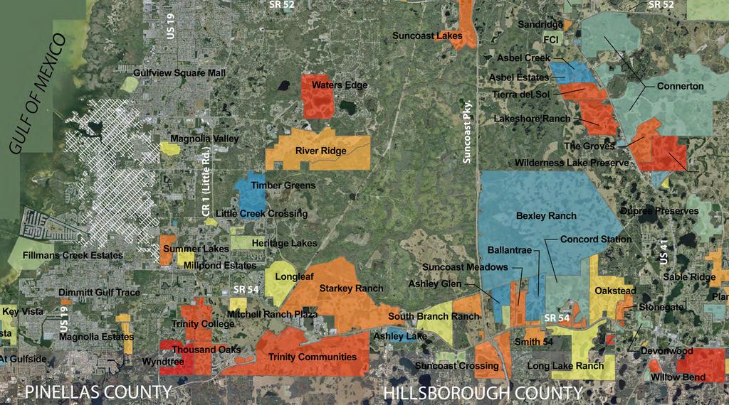
41 Bexley

42 Bexley Ranch 5,530 Homes 850,000 SF Commercial
 Highways Pedestrian Facilities (Sidewalks and Trails) Transit")
43 Top 4 Priorities for Transportation Investment: Local Roads Citizen Survey Results Summary (2011 & 2012) Highways Pedestrian Facilities (Sidewalks and Trails) Transit (Buses)


44 Current Study EXPANDED Corridor Evaluation (East 56) Begin Project End Project
45 SR 54/SR 56 Transit/Managed Lane Toll Feasibility Study Study Objectives: Perform planning-level build toll demand traffic estimates, assess optimal toll rates, revenue estimates, O&M costs, etc. Determine the ROW needs associated with the elevated and/or at-grade managed lane concept along the SR 54/56 corridor (US 19 to US 301)
46 Key Study Activities Determine proposed alignment of managed lanes Establish lane configuration Develop typical sections Set entrance and exit points between managed lanes/premium transit and general-use lanes Establish type/location of transit stations; including pedestrian access
47 Establish type/location of park-and-ride lots; Identify stormwater management/other drainage issues; Determination of preliminary/final costs PE/Construction Develop staging plan for implementation
48 Project Schedule (Needs Updating) Travel Demand Modeling Toll Revenue Cost Estimates/Staging Plan Drainage/ROW Preservation Public Outreach underway 2 Months 2 Months 2 Months Throughout Study Total Schedule: 6 Months
49 Summary 1. Years of studies concerning the 54/56 corridor 2. At grade solutions found to be not practical 3. Exclusive guideway for Light Rail produces low ridership and is not feasible 4. FDOT believes the future for increased highway capacity lies with Toll (managed lane) facilities. 5. Tolled Elevated Managed Lanes- Only practical solution which provides Capacity for both vehicles and transit 6. Only practical solution to fully accommodate Bus Rapid Transit (BRT) within the corridor
50 Summary 7. The recommended solution has been the result of a coordinated Regional effort 8. The SR 54/56 Elevated Managed Lane facility is required to complete the Tampa Bay Northern Loop 9. Provides the least Financial Impact on Pasco residents & frees up revenue for other county transportation needs 10. Future development based on current Entitlements along SR 54/56 depends upon an Elevated Managed Lane facility 11. Recommended solution best protects existing and future businesses along the corridor. 12. Planning stage on-going built in 3 to 4 segments
51 Comparison: 8 Surface Lanes with 4 Elevated Managed Lanes vs. 16 Surface Lanes 8 Surface Lanes 4 Elevated Managed Lanes 252 ROW 16 Surface Lanes

52 15 Bldg. Setback 252 ROW 16 Surface Lanes within 252 ROW 20 Buffer

53 16 Surface Lanes within 252 ROW

54 252 ROW 15 Bldg. Setba 20 Buffer 8 Surface Lanes 4 Elevated Managed Lanes within 252 ROW

55 8 Surface Lanes 4 Elevated Managed Lanes within 252 ROW

56 Comparison: 8 Surface Lanes with 4 Elevated Managed Lanes vs. 16 Surface Lanes 8 Surface Lanes 4 Elevated Managed Lanes 252 ROW 16 Surface Lanes
Introduction. Project Need
 Introduction The purpose of Subtask 1 of the SR 54/56 Project Concept Development (PCD) Study is to identify and summarize the goals and proposed operations for transit corridor improvements as depicted
APPENDIX G: INTERSECTION NEEDS AT OKEECHOBEE BOULEVARD
 APPENDIX G: INTERSECTION NEEDS AT OKEECHOBEE BOULEVARD INTERSECTION NEEDS AT SR 7 and OKEECHOBEE BOULEVARD SR 7 Extension Project Development and Environment (PD&E) Study From Okeechobee Boulevard (SR
Scottsdale Road/Rural Road Alternatives Analysis (AA) Study. Arizona ITE/IMSA Spring Conference March 7, 2012
 Study. Arizona ITE/IMSA Spring Conference March 7, 2012") Scottsdale Road/Rural Road Alternatives Analysis (AA) Study Arizona ITE/IMSA Spring Conference March 7, 2012 Study Location and Duration Primary Study Corridor (major focus of effort) Rural Road and Scottsdale
Scottsdale Road/Rural Road Alternatives Analysis (AA) Study Arizona ITE/IMSA Spring Conference March 7, 2012 Study Location and Duration Primary Study Corridor (major focus of effort) Rural Road and Scottsdale
Downtown BRT Corridor Alternatives Review: 1 st, 2 nd, 3 rd and 4 th Avenue. Bus Rapid and Conventional Transit Planning and Design Services
 Downtown BRT Corridor Alternatives Review: 1 st, 2 nd, 3 rd and 4 th Avenue Bus Rapid and Conventional Transit Planning and Design Services City of Saskatoon February 2018 Project Team HDR Corporation
Giles Run Connector Road
 Giles Run Connector Road Laurel Hill Adaptive Reuse Area to Laurel Crest Drive South County Federation Meeting June 14, 2016 History Connector road included in the Laurel Hill Comprehensive Plan amendment
Performance Criteria for 2035 Long Range Transportation Plan
 Minimizing Impacts on Natural, Historic, Cultural or Archeological Resources 2035 LRTP Weighting Factor: 7% Objective 1.1: Use appropriate planning and design criteria to protect and enhance the built
Southwest Bus Rapid Transit (SW BRT) Functional Planning Study - Executive Summary January 19 LPT ATTACHMENT 2.
 Functional Planning Study - Executive Summary January 19 LPT ATTACHMENT 2.") Southwest Bus Rapid Transit (SW BRT) Functional Planning Study - Executive Summary 2011 January 19 1 of 19 Introduction This executive summary presents the results of the Southwest Bus Rapid Transit (SW
Southwest Bus Rapid Transit (SW BRT) Functional Planning Study - Executive Summary 2011 January 19 1 of 19 Introduction This executive summary presents the results of the Southwest Bus Rapid Transit (SW
5. RUNNINGWAY GUIDELINES
 5. RUNNINGWAY GUIDELINES These guidelines should be considered collectively when making runningway decisions. A runningway is the linear component of the transit system that forms the right-of-way reserved
Creating the Future Bruce B Downs Blvd
 Creating the Future Bruce B Downs Blvd How things look today May not be how things look in the future. Bruce B Downs PD&E Study 2003 Construction programmed 2009, Palm Springs to Pebble Creek Tampa Rail
Main-McVay Transit Study: Phase 2 Options Definition and High Level Constraints Evaluation
 Main-McVay Transit Study: Phase 2 Options Definition and High Level Constraints Evaluation APRIL 2016 A collaborative study between: For Additional Information or to Comment If you would like additional
City of Gainesville Transportation/Roadway Needs PROJECT SUMMARY
 A1 Roadway Resurfacing $23,846,000 TYPE: Preservation of existing system Roadway resurfacing A2 Signal Replacement $6,000,000 TYPE: Preservation of existing system Replace traffic signals. B1 W 6th St
Durham Region Long Term Transit Strategy
 Durham Region Long Term Transit Strategy An adaptive, safe, reliable, frequent, accessible and desirable transit system that shapes and connects Durham Region and beyond in an economically and environmentally
US 1 Express Lanes Public Kick-Off Meeting
 US 1 Express Lanes Project Development & Environment (PD&E) Study Public Kick-Off Meeting September 7 & 8, 2011 Miami Dade County, Florida 1 Presentation Agenda Introduction to MDX Background to PD&E studies
1. Provide a dedicated westbound approach bus lane at the intersection;
 3. MODIFICATIONS AT HIGHWAY 417 WESTBOUND OFF-RAMP/PINCREST ROAD - PUBLIC HEARING COMMITTEE RECOMMENDATIONS Having held a public hearing, that Council approve the preliminary design for the proposed modifications
Definition of Feasible Alternatives Technical Memorandum 2 MULTIMODAL TRANSIT AND MANAGED LANES FEASIBILITY EVALUATION FOR SR 54/56 CORRIDOR - US 19
 Definition of Feasible Alternatives Technical Memorandum MULTIMODAL TRANSIT AND MANAGED LANES FEASIBILITY EVALUATION FOR /56 CORRIDOR - US 9 TO BRUCE B. DOWNS BOULEVARD January 0 Table of Contents.0 Introduction....0
Project Mobility - Route 3 South Express Toll Lanes. Industry Day Overview
 Project Mobility - Route 3 South Express Toll Lanes Industry Day Overview October 15, 2014 Today s Agenda Project Mobility Overview Design Alternatives and Construction Estimates Existing Traffic Congestion/Project
INNER LOOP EAST. AIA Rochester Annual Meeting November 13, 2013 TRANSFORMATION PROJECT. Bret Garwood, NBD Erik Frisch, DES
 INNER LOOP EAST TRANSFORMATION PROJECT AIA Rochester Annual Meeting November 13, 2013 Bret Garwood, NBD Erik Frisch, DES Why? We are building a city that encourages walking, biking and enjoying the outdoor
Alternatives Public Workshop
 US 1 Express Lanes Project Development & Environment (PD&E) Study Alternatives Public Workshop August 2013 1 Today s Agenda Project Background and Overview Tier 1 Alternatives Development Tier 2 Decision-Making
RIVERSIDE, Newton MA BH NORMANDY RIVERSIDE LLC. Riverside Station. A green, transit-oriented community
 Riverside Station A green, transit-oriented community October 6, 2011 TONIGHT S AGENDA: 1. Project Update (5 min.) 2. Master Plan Update (10 min.) 3.Traffic Plan Update (10 min.) Questions & Answers MASTER
Highway Transitway Corridor Study
 Highway Transitway Corridor Study CTS Research Conference May 21, 2014 1 2030 Transportation Policy Plan Transitway modes on highways: Highway bus rapid transit (BRT), plan identified 6 total Highway BRT
Operational Comparison of Transit Signal Priority Strategies
 Operational Comparison of Transit Signal Priority Strategies Revision Submitted on: November, 0 Author: Adriana Rodriguez, E.I Assistant Engineer Parsons Brinckerhoff 0 South Orange Avenue, Suite 00 Orlando,
Regional Transportation Needs Within Southeastern Wisconsin
 Regional Transportation Needs Within Southeastern Wisconsin #118274 May 24, 2006 1 Introduction The Southeastern Wisconsin Regional Planning Commission (SEWRPC) is the official areawide planning agency
FINAL DESIGN TRAFFIC TECHNICAL MEMORANDUM
 FINAL DESIGN TRAFFIC TECHNICAL MEMORANDUM July 2014 FINAL (SR 43) Project Development and Environment Study From State Road 60 (Adamo Drive) to I-4 (SR 400) Hillsborough County, Florida Work Program Item
I-35W Solutions Alliance Project Update July 13, 2017
 Title I-35W Solutions Alliance Project Update July 13, 2017 Evaluating the potential for Bus Rapid Transit and MnPASS Express Lanes in the southwest Metro, Investigating options for improved bus service
Multimodal Through Corridors and Placemaking Corridors
 68 Multimodal Through Corridors and Placemaking Corridors Corridors have different functions in a region. Some corridors are used to get smoothly and rapidly through a region or to get quickly to major
EXECUTIVE SUMMARY... vii 1 STUDY OVERVIEW Study Scope Study Area Study Objectives
 Contents EXECUTIVE SUMMARY... vii 1 STUDY OVERVIEW... 1-1 1.1 Study Scope... 1-1 1.2 Study Area... 1-1 1.3 Study Objectives... 1-3 2 EXISTING CONDITIONS... 2-1 2.1 Existing Freeway Conditions... 2-4 2.1.1
Appendix C. NORTH METRO STATION AREA TRAFFIC IMPACT STATEMENT 88th Avenue Station
 Appendix C NORTH METRO STATION AREA TRAFFIC IMPACT STATEMENT 88th Avenue Station Prepared for: Regional Transportation Department and URS Corporation as part of the North Metro EIS David Evans and Associates,
BUS RAPID TRANSIT. A Canadian Perspective. McCormick Rankin International. John Bonsall P.Eng
 BUS RAPID TRANSIT A Canadian Perspective Why choose BRT? Because it is a practical and cost effective rapid transit solution for the most common types of land use in urban Canada Operating experience shows
ROUTES 55 / 42 / 676 BUS RAPID TRANSIT LOCALLY PREFERRED ALTERNATIVE
 ROUTES 55 / 42 / 676 BUS RAPID TRANSIT LOCALLY PREFERRED ALTERNATIVE April, 2012 1 INTRODUCTION The need for transit service improvements in the Routes 42/55/676 corridor was identified during the Southern
Transportation Corridor Studies: Summary of Recommendations
 Transportation Corridor Studies: Summary of Recommendations Route 4 Corridor Study: Route 10 Corridor Study: Route 44 Corridor Study: Route 175 Corridor Study: Route 5/15 Corridor Study: Rentschler Field
Board of Supervisors February 27, 2017
 : Traffic Analysis Results & Draft Conceptual Plan Board of Supervisors February 27, 2017 Transportation Solutions Building Better Communities Presentation Overview Background Summary of Traffic Analysis
Bluffdale/ UDOT South High-T Intersection Project Type Operations
 Bluffdale/ UDOT 14600 South High-T Intersection Project Type Operations 14600 South and Redwood Road $ 600,000 $ 550,000 This project is to install a new High-T intersection at Redwood Road and 14600 South
Dr. M.L. King, Jr. Street North Complete Streets Resurfacing Opportunities HOUSING, LAND USE, AND TRANSPORTATION COMMITTEE MARCH 22, 2018
 Dr. M.L. King, Jr. Street North Complete Streets Resurfacing Opportunities HOUSING, LAND USE, AND TRANSPORTATION COMMITTEE MARCH 22, 2018 What s Happening The City plans to mill and resurface Dr. M.L.
Managed Lanes. Steve Schilke, P.E. Major Projects Unit Head District 1. Illinois Traffic Engineering and Safety Conference October 2016
 Managed Lanes Steve Schilke, P.E. Major Projects Unit Head District 1 Illinois Traffic Engineering and Safety Conference October 2016 Agenda Managed Lanes Projects I-55 (Stevenson Expressway) Express Toll
Welcome to the Quebec Alternatives Analysis Public Meeting
 Welcome to the Public Meeting Please sign in. Public Comment Please fill out a comment card and tell us what you think. Check back or comment any time at: www.quebecalternatives.com Project Area Technical
Project Description Form 8EE
 Project Description Form 8EE Basic Project Information Submitting Jurisdiction/Agency: Town of Dumfries Project Title: Route 1 (Fraley Blvd) Widening: Brady's Hill Road to Dumfries Road Project Location:
Chapter 5 Future Transportation
 Chapter 5 Future Transportation The Future Land Use Plan identifies the desired land use designations. The land uses desired for Crozet depend, in large part, on the success of the transportation system,
Chris e Zimmer made a mo on to include Alterna ve G (modified to include grade separa on at signalized
 MOBILITY 2040: A Vision for the SR 54/56 Corridor Phase 1: Defining the Alternatives East Task Force Meeting Thursday, March 31, 2016 (5:30 7:30 PM) Rasmussen College, Room #102 18600 Fernview Street,
David Jickling, Public Transportation Director Regional Transportation Commission, Washoe County
 David Jickling, Public Transportation Director Regional Transportation Commission, Washoe County Virginia Street Resort corridor connecting University of Nevada, Reno Downtown Truckee River Strip Casinos
Maywood Town Hall Meeting. May 4, 2016
 Maywood Town Hall Meeting May 4, 2016 1 AGENDA Overall I-290 Study Background Maywood Advisory Working Group (AWG) findings to date Noise Wall Update Next Steps 2 Questions? Study team members also available
Recommended Roadway Plan Section 2 - Land Development and Roadway Access
 Recommended Roadway Plan Section 2 - Land Development and Roadway Access SECTION 2 Land Development and Roadway Access 2.1 Land Use and Access Management The Federal Highway Administration (FHWA) defines
3.0 PROJECT DESCRIPTION
 The following section of the Draft EIR contains a description of the proposed Elk Grove Boulevard/SR 99 Interchange Modification project, consistent with the requirements of CEQA Guidelines Section 15124.
Chapter 3 BUS IMPROVEMENT CONCEPTS
 Chapter 3 BUS IMPROVEMENT CONCEPTS The purpose of this chapter is to describe potential bus improvement strategies and potential impacts or implications associated with BRT implementation within the existing
SANTA MONICA BOULEVARD CORRIDOR
 CIRCULATION ELEMENT WHITE PAPER NO. 3 SANTA MONICA BOULEVARD CORRIDOR INTRODUCTION From the 1930s to the beginning of Los Angeles freeway era, Santa Monica Boulevard, (previously Route 66, the Beverly
Terwillegar Drive Expressway Draft Concept Plan
 Terwillegar Drive Expressway Draft Concept Plan Anthony Henday Drive to Whitemud Drive November 28 5:00-8:00 p.m. December 1 10:00 a.m. - 3:00 p.m. Let s Talk Today you can: Learn about the new direction
Preliminary Transportation Analysis
 Preliminary Transportation Analysis Goals of a Robust, Multimodal Transportation Network Safe Accessible/Connected Efficient Comfortable Context-Sensitive Motor Vehicle: Continue to analyze the data to
REGIONAL PRIORITIES Presentation to the Tampa Bay Regional Collaboration Committee September 10, 2012
 WEST CENTRAL FLORIDA MPO CHAIRS COORDINATING COMMITTEE REGIONAL PRIORITIES Presentation to the Tampa Bay Regional Collaboration Committee September 10, 2012 TRANSPORTATION REGIONAL INCENTIVE PROGRAM (TRIP)
BETHEL ROAD AND SEDGWICK ROAD CORRIDOR STUDY
 DRAFT PLAN City Council Meeting August 14, 2017 STUDY AREA Sedgwick Corridor State Route 160, principal arterial with Class 3 access management designation, commuter and freight route, connection to SR
US 19 Pedestrian and Bicycle Safe Access to Transit Corridor Study
 US 19 Pedestrian and Bicycle Safe Access to Transit Corridor Study DRAFT Technical Memorandum #6 Cost and Benefit Evaluation Methodology August 2016 Prepared for: FLORIDA DEPARTMENT OF TRANSPORTATION DISTRICT
PURPOSE AND NEED SUMMARY 54% Corridor Need 1. Corridor Need 2. Corridor Need 3. Corridor Need 4. Corridor Need 5
 SUMMARY PURPOSE AND NEED Chapel Hill Transit ridership has increased Buses operate every 4 minutes and have standing room only Exceeding seated capacity by 12% Corridor Need 1 by more than 20 percent between
US 41 COMPLETE STREETS CORRIDOR PLANNING STUDY from University Parkway to Whitfield Avenue
 41 US 41 COMPLETE STREETS CORRIDOR PLANNING STUDY from University Parkway to Whitfield Avenue EXECUTIVE SUMMARY DRAFT FEBRUARY 2019 Project Overview The US 41 Complete Streets Corridor Planning Study,
State Street and Pierce Park Lane Intersection Concept Report
 State Street and Pierce Park Lane Intersection Prepared for September 2017 Prepared by CITATION Parametrix. 2017. State Street & Pierce Park Lane Intersection. Prepared by Parametrix, Boise, ID. September
Summary: Mercer County Princeton Avenue & Spruce Street Study January 2009
 Summary: Several recent studies have assessed potential development and redevelopment opportunities in the Mercer Crossing area of Trenton, Ewing, and Lawrence. This Princeton Avenue and Spruce Street
South King County High-Capacity Transit Corridor Study
 HIGH-CAPACITY TRANSIT CORRIDOR STUDY South King County Corridor South King County High-Capacity Transit Corridor Study Corridor Report August 2014 South King County High Capacity Transit Corridor Report
US 19 Pedestrian and Bicycle Safe Access to Transit Corridor Study
 US 19 Pedestrian and Bicycle Safe Access to Transit Corridor Study Summary Report October 2016 Prepared for: FLORIDA DEPARTMENT OF TRANSPORTATION DISTRICT 7 (FDOT) Contract No: C 9B41, FAP No: 8886 318
List of Display Boards
 List of Display Boards Welcome Introduction Municipal Class Environmental Assessment (EA) Process Need and Justification for an Interchange Alternatives for Evaluation Vertical and Horizontal Alignments
Los Altos Hills Town Council - June 18, 2015 Palo Alto City Council June 22, AGENDA ITEM #2.B Presentation
 Los Altos Hills Town Council - June 18, 2015 Palo Alto City Council June 22, 2015 AGENDA ITEM #2.B Presentation Previous Presentations Los Altos Hills Town Council in May 2014 and February 2015 Palo Alto
Station Plan: Penn & 43rd Avenue
 Station Plan: Penn & 43rd Avenue This station will serve the northern portion of the Penn Avenue corridor, including the commercial node at 44th Avenue. Ridership and roadway geometry support station siting
Roadways. Roadways III.
 Introduction 97 Roadway Design Principles 98 Safe Speeds 99 Optimizing of Street Space 00 Minimum Lane Widths in the City of Boston 02 Design Features that Reduce Operating Speeds 05 Travel Lanes Transit
Route 29 Corridor Assessment Update. Development of Possible Solutions
 Route 29 Corridor Assessment Update Development of Possible Solutions Public Workshop #3 October 27, 2016 Purpose of Developing Possible Solutions Recap of where we ve been and timeline for moving forward
Project Description Form 6V
 Project Description Form 6V Basic Project Information Submitting Jurisdiction/Agency: Prince William County Project Title: Route 15 Widening: Route 55 to south of RR tracks & Construct RR Overpass Project
COWETA HIGH SCHOOL AND EAST HIGHWAY 51
 COWETA HIGH SCHOOL AND EAST HIGHWAY 51 Lack of sidewalks along Ben Lumpkin Rd. Lack of crosswalks and ramps at intersection. Hwy 51 is wide to cross as a pedestrian. No ADA compliance or connection to
DEPARTMENT OF ENVIRONMENTAL SERVICES. North Harrison Street (Lee Highway to Little Falls Road) Comparative Analysis. Prepared for:
 Comparative Analysis. Prepared for:") DEPARTMENT OF ENVIRONMENTAL SERVICES North Harrison Street (Lee Highway to Little Falls Road) Comparative Analysis Prepared for: Arlington County Department of Environmental Services 2100 Clarendon Boulevard,
DEPARTMENT OF ENVIRONMENTAL SERVICES North Harrison Street (Lee Highway to Little Falls Road) Comparative Analysis Prepared for: Arlington County Department of Environmental Services 2100 Clarendon Boulevard,
In station areas, new pedestrian links can increase network connectivity and provide direct access to stations.
 The Last Mile Planning for Pedestrians Planning around stations will put pedestrians first. Making walking to stations safe and easy is important; walking will be a part of every rapid transit Accessible
US HIGHWAY 19 CORRIDOR CONDITIONS, TRENDS, PLANNING ACTIVITIES. Pinellas County Metropolitan Planning Organization
 US HIGHWAY 19 CORRIDOR CONDITIONS, TRENDS, PLANNING ACTIVITIES Pinellas County Metropolitan Planning Organization September 9, 9 2015 US Highway 19 Conditions, i Trends, Planning Activities i i Traffic
Paul Huston, P.E., Design-Build Coordinator Chuck Gonderinger, HDR Engineering. Minnesota Department of Transportation (the Department)
") To: From: Paul Huston, P.E., Design-Build Coordinator Chuck Gonderinger, HDR Engineering Date: March 20, 2001 Subject: Roadway Geometric Design Criteria Project: TH 14/218 Design-Build Project, SP 7408-29,
To: From: Paul Huston, P.E., Design-Build Coordinator Chuck Gonderinger, HDR Engineering Date: March 20, 2001 Subject: Roadway Geometric Design Criteria Project: TH 14/218 Design-Build Project, SP 7408-29,
5. MODIFICATIONS AT JEANNE D ARC BOULEVARD/REGIONAL ROAD 174 INTERCHANGE INTERSECTION - PUBLIC HEARING COMMITTEE RECOMMENDATION
 5. MODIFICATIONS AT JEANNE D ARC BOULEVARD/REGIONAL ROAD 174 INTERCHANGE INTERSECTION - PUBLIC HEARING COMMITTEE RECOMMENDATION Having held a public hearing, that Council approve the preliminary designs
Thank you for attending
 Improving mobility safety comfort WELCOME Thank you for attending The purpose of this meeting is to: Learn about the project Prioritize potential walking and biking improvements on Snelling Ave Gather
San Jose Transportation Policy
 San Jose Transportation Policy Protected Intersections in LOS Policies to Support Smart Growth Presented by: Manuel Pineda City of San Jose Department of Transportation Bay Area Map San Francisco Oakland
Waterford Lakes Small Area Study
 Waterford Lakes Small Area Study Existing Traffic Conditions PREPARED FOR: ORANGE COUNTY PUBLIC WORKS DEPARTMENT TRAFFIC ENGINEERING DIVISION ORLANDO, FLORIDA PREPARED WITH: INWOOD CONSULTING ENGINEERS
Decision on North Waterloo Routing
 Next Steps Decision on North Waterloo Routing Two route variations remain in north Waterloo. The final preferred route will include only one of the two variations. Please consider these two variations
University Hill Transportation Study Technical Memorandum Alternatives Modeling and Analysis May 2007
 Technical Memorandum May 2007 Syracuse Metropolitan Transportation Council Edwards and Kelcey with Wallace Roberts and Todd Alta Planning and Design CONTENTS SECTION ONE- INTRODUCTION...1 SECTION TWO-
Metropolitan Council Transportation Committee
 Nicollet-Central Transit Alternatives Metropolitan Council Transportation Committee August 2013 Project Purpose (approved by Policy Advisory Committee 10/25/2012) The purpose is to improve transit connectivity,
M-58 HIGHWAY ACCESS MANAGEMENT STUDY Mullen Road to Bel-Ray Boulevard. Prepared for CITY OF BELTON. May 2016
 M-58 HIGHWAY ACCESS MANAGEMENT STUDY Prepared for CITY OF BELTON By May 2016 Introduction Missouri State Highway 58 (M-58 Highway) is a major commercial corridor in the City of Belton. As development has
Dumbarton Transportation Corridor Study. San Francisco Bay ITE November 2016
 Dumbarton Transportation Corridor Study San Francisco Bay ITE November 2016 Dumbarton Corridor Source: Wikipedia 2 Dumbarton Corridor 3 Growth Imbalance Jobs-housing imbalance Major employers driving growth
STATION #3 INITIAL ALTERNATIVES
 www.dot.il.gov www.eisenhowerexpressway.com STATIO #3 IHB RR Heavy Rail Transit (HRT) High capacity transit mode serving urban areas:» Steel wheeled, high performance electric powered rail vehicles» Right-of-way
Typical Rush Hour Commute. PennyforTransportation.com
 Typical Rush Hour Commute In the News Overview of the Plan Collaborative plan with projects in every community Prioritizing connectivity and congestion relief Dedicated transportation-specific funding;
Interim Transit Ridership Forecast Results Technical Memorandum
 Interim Transit Ridership 401 South Jackson Street Seattle, WA 98104-2826 September 2012 Table of Contents 1 INTRODUCTION... 1-1 1.1 Project Background... 1-1 2 RIDERSHIP FORECASTS... 2-1 2.1 System Ridership
Princeton Avenue and Spruce Street Transportation and Site Access Enhancements Project
 Princeton Avenue and Spruce Street Transportation and Site Access Enhancements Project Mercer County Planning Division AECOM Transportation (formerly DMJM Harris) January 29, 2009 Agenda Project Status
Feasibility Study of Pedestrian Crossings Along Route 7, East of Cascades Parkway and West of Dranesville Road. October 3, 2017
 Feasibility Study of Pedestrian Crossings Along Route 7, East of Cascades Parkway and West of Dranesville Road October 3, 2017 Study Area (area within a ¼-mile radius of the study intersections) Route
MCTC 2018 RTP SCS and Madera County RIFP Multi-Modal Project Eval Criteria GV13.xlsx
 MCTC 8 RTP SCS and Madera County RIFP Multi-Modal Project Eval Criteria GV.xlsx Madera County Transportation Commission Regional Transportation Plan / Sustainable Communities Strategy Multi-Modal Project
Executive Summary Route 30 Corridor Master Plan
 Route Corridor Master Plan Project Overview The Route Corridor Master Plan is a coordinated multimodal transportation and land use plan for the entire stretch of Route through East Whiteland Township,
MARTA Expansion Update
 MARTA Expansion Update CITY OF SANDY SPRINGS BRIEFING January 2019 BACKGROUND: GA 400 TRANSIT INITIATIVE 2011-2015 2015 2017 2018 2018- Present MARTA NEPA Planning Heavy Rail Transit (HRT) Bus Rapid Transit
Item to be Addressed Checklist Consideration YES NO N/A Required Description Complete Streets Guidelines
 Passaic County Complete Streets Checklist - Concept Development Project Name Item to be Addressed Checklist Consideration YES NO N/A Required Description Complete Streets Guidelines Existing Plans Have
Bus Rapid Transit Plans
 Twin Cities Region Bus Rapid Transit Plans ULI Minnesota Workshop Connecting Bus Rapid Transit to the Community December 15, 2009 John Levin Director of Service Development Metro Transit Metropolitan Area
Dr. Naveed Anwar Executive Director, AIT Consulting Affiliated Faculty, Structural Engineering Director, ACECOMS
 Dr. Naveed Anwar Executive Director, AIT Consulting Affiliated Faculty, Structural Engineering Director, ACECOMS Overview Highway Functions and Classifications Highway Design Components Design Control
Eliminate on-street parking where it will allow for a dedicated bus only lane %
 Traffic Dashboard Priorities Survey Responses Introduction 1) Are you familiar with bus rapid transit (BRT)? a. No, BRT is new to me. 597 23.5% b. I ve heard of BRT, but I don t know much about it. 1,136
DULLES AREA TRANSPORTATION ASSOCIATION (DATA) February 18, Susan Shaw, P.E., VDOT, Megaprojects Director
 February 18, Susan Shaw, P.E., VDOT, Megaprojects Director") DULLES AREA TRANSPORTATION ASSOCIATION (DATA) February 18, 2015 Susan Shaw, P.E., VDOT, Megaprojects Director I-66 Corridor Conditions Steady population growth Employment growth in activity centers Congestion
DULLES AREA TRANSPORTATION ASSOCIATION (DATA) February 18, 2015 Susan Shaw, P.E., VDOT, Megaprojects Director I-66 Corridor Conditions Steady population growth Employment growth in activity centers Congestion
Chapter 7. Transportation. Transportation Road Network Plan Transit Cyclists Pedestrians Multi-Use and Equestrian Trails
 Chapter 7 Transportation Transportation Road Network Plan Transit Cyclists Pedestrians Multi-Use and Equestrian Trails 7.1 TRANSPORTATION BACKGROUND The District of Maple Ridge faces a number of unique
Reversible Elevated Express Lanes. A Solution for Urban Traffic Congestion
 Lee Roy Selmon Crosstown Expressway Reversible Elevated Express Lanes A Solution for Urban Traffic Congestion Martin Stone, Ph.D., AICP Director of Planning Tampa-Hillsborough Expressway Authority Pensacola
WEST AND SOUTH WEST RING ROAD DOWNSTREAM TRAFFIC IMPACTS
 Page 1 of 9 EXECUTIVE SUMMARY Alberta Transportation ( AT ) is preparing to construct the final sections of the Calgary Ring Road. This includes the South West Ring Road ( SWRR ) (from Lott Creek Blvd
Transportation Planning Division
 Transportation Planning Division Presentation Outline Study Tasks Recap of Previous Meetings Data Collected Focus Areas within Study Limits Design Principles Tool Box Recommended Concepts Schedule Moving
Geary Corridor Bus Rapid Transit SFMTA Citizens Advisory Committee
 Geary Corridor Bus Rapid Transit SFMTA Citizens Advisory Committee Project Update SAN FRANCISCO COUNTY TRANSPORTATION AUTHORITY SAN FRANCISCO MUNICIPAL TRANSPORTATION AGENCY August 6, 2015 Project Overview
1. Operate along freeways, either in regular traffic lanes, in high-occupancy vehicle (HOV) lanes, or along the shoulders.
 lanes, or along the shoulders.") Most decisions about whether or not to use transit involve time and cost, and most transit services are slower than travel by private vehicle. However, when transit is faster or nearly as fast as travel
Most decisions about whether or not to use transit involve time and cost, and most transit services are slower than travel by private vehicle. However, when transit is faster or nearly as fast as travel
FLORIDA DEPARTMENT OF TRANSPORTATION DISTRICT 7 DISTRICT WIDE BICYCLE/PEDESTRIAN ACCESS TO TRANSIT SAFETY ASSESSMENT AND IMPROVEMENT PLAN
 FLORIDA DEPARTMENT OF TRANSPORTATION DISTRICT 7 DISTRICT WIDE BICYCLE/PEDESTRIAN ACCESS TO TRANSIT SAFETY ASSESSMENT AND IMPROVEMENT PLAN TRANSIT SAFETY ASSESSMENT SR 55/US 19 AT 80 TH AVE N DRAFT JUNE
WELCOME! Please complete a comment sheet as we value your feedback. 4 pm to 8 pm. September 15, Hosted by: AECOM on behalf of City of Calgary
 WELCOME! Thank you for attending our open house. There will be no formal presentation today so please take the time to read the boards. If you have any questions, please do not hesitate to approach one
Meeting Summary Public Information Meeting #1 Warren County Pathway Corridor Project September 27, 2018
 Meeting Summary Public Information Meeting #1 Warren County Pathway Corridor Project September 27, 2018 The first public information meeting for the Warren County Pathway Corridor Project was held on Thursday,
MONTGOMERY COUNTY PLANNING DEPARTMENT THE MARYLAND-NATIONAL CAPITAL PARK AND PLANNING COMMISSION
 MONTGOMERY COUNTY PLANNING DEPARTMENT THE MARYLAND-NATIONAL CAPITAL PARK AND PLANNING COMMISSION SHA CTP Project No. MO891A21, US 29, Fairland Road to Musgrove Road Interchange Improvement, Design Review
Appendix A-K Public Information Centre 2 Materials
 Appendix A-K Public Information Centre 2 Materials Our Rapid Transit Initiative Make an impact on the future of transit Join the discussion on Rapid Transit in London You re invited to a Public Information
Route 7 Corridor Study
 Route 7 Corridor Study Executive Summary Study Area The following report analyzes a segment of the Virginia State Route 7 corridor. The corridor study area, spanning over 5 miles in length, is a multi