Bay to Bay Boulevard Complete Streets Project
|
|
|
- Asher Thomas
- 5 years ago
- Views:
Transcription

1 Bay to Bay Boulevard Complete Streets Project Dale Mabry Highway to Bayshore Boulevard February 08, 2018 Photo Source: Tampa Bay Times Alessandra Da Pra
2 Meeting Format Introduction Resurfacing Information Project Information City of Tampa Questions/Answers 2
3 Introduction 3
4 Resurfacing Information Milling and resurfacing Bay to Bay Blvd from East of Dale Mabry Hwy to West of Bayshore Blvd, and upgrading curb ramps for compliance with the Americans with Disabilities Act (ADA). Construction Start = Fall
5 MacDill Ave Himes Ave Dale Mabry Hwy Project Information and Development Bay to Bay Blvd The City of Tampa is considering implementing a complete streets project along Bay to Bay Boulevard. This project consists of two distinct sections: 1. A complete streets project between Dale Mabry Highway and Esperanza Avenue. 2. A roadway capacity project between Esperanza Avenue and Bayshore Blvd. 5


6 What are Complete Streets? Complete Streets are designed so all modes of transportation can share the road safely. 6


7 The Right Street in the Right Place There is no single design application for Complete Streets; each one is unique and responds to its community context. 7


8 What is Bay to Bay Blvd.? Collector Roadway Connection to Downtown Connection to Lee Roy Selmon Expressway and Bayshore Blvd. Commercial Center Retail Stores and Offices line Bay to Bay Blvd. Entertainment Corridor Many Restaurants, Coffee Houses, and Night Clubs Neighborhood Center Multiple Places of Worship Assisted Living Facility Crossings for Schools Residential Roadway Over a dozen single family homes Bus Route W. Bay to Bay Blvd. 8

9 How did this Project Originate? City of Tampa Walk Bike Plan, 2012 Multi Phased plan to identify opportunities for enhanced bicycle and pedestrian mobility throughout the City. Developed by the Hillsborough County MPO working in close coordination with the City of Tampa. Provide for cross city North South and East West connections, specifically bike lanes El Prado Blvd. is a similar project recommended in South Tampa 9
10 Complete Streets Resolutions City Reso ; Section 7: That the provisions set forth in this Resolution should be employed where appropriate and financially feasible in all transportation planning, design, review, operations, major maintenance projects (such as milling and overlay), new construction, and reconstruction projects. City departments including Public Works, Transportation, Growth Management and Development Services and Parks and Recreation should consider the provisions of this Resolution as they plan, design and review improvements within the City's rights of way. BAY TO BAY BOULEVARD COMPLETE STREETS10PROJECT
11 Complete Streets Resolutions City Resolution (Feb 16, 2012) City Reso ; Section 4: Sidewalk space for pedestrians; Bicycle lanes or bicycle routes; Appropriately sized travel lanes Transit vehicles, facilities and routes; On street parking where applicable; Median use for traffic flow, safety, and pedestrian refuge; Buffer areas Landscaping/hardscaping; Land use context. BAY TO BAY BOULEVARD COMPLETE STREETS11PROJECT

12 Why Now? The City initiated a traffic study in June 2016 to analyze the existing roadway conditions to see what safety and operational improvements could be made In August 2016, the County informed the City that W. Bay to Bay Blvd. was scheduled for resurfacing Source: City of Tampa Walk Bike Plan, Phase II 12


13 Traffic Terms Volume = amount of traffic that a roadway experiences Capacity = how much traffic volume a roadway can handle Engineers analyze and design roadways to handle traffic at their Peak Hour, time of day that volume is highest. Level of Service = ranking or grade of how well a roadway operates LOS A= free flow traffic LOS D= acceptable LOS F= highly congested traffic 13


14 4 Lane to 3 Lane Conversion In the 1950 s and 1960 s, suburbs were growing, roadway projects were focused on expansion. Many of the two lane roads were expanded to 4 lane roadways. At this time, there simply was no engineering guidance on 3 lane roadways. Three lane sections first started to appear in the 1970 s where expansion was needed, but right of way was scarce. After the safety and capacity benefits became known, the popularity increased starting in the 1990 s. Since this time, there has been a big spike in roadway conversions. 14
 Bay")
15 Is Bay to Bay Blvd. a Good Candidate? The FHWA recommends a threshold of 20,000 AADT (Average Annual Average Daily Traffic) Bay to Bay Blvd (from Dale Mabry to Himes) AADT= 18,439 15


16 Capacity of a Three Lane Road 4 lane roads operate like a 3 lane road Outside lanes slowed by right turners, busses, and garbage trucks. Inside lanes delayed by left turning vehicles slowing and stopping Bay to Bay Blvd. has 81 possible left turns in 6/10 th of a mile 6 cross streets and 69 driveway cuts between Dale Mabry Hwy and Esperanza Ave. Only 19 Single Family Homes 81 possible left turns over 3,275 ft One every 40 feet Turning vehicles create a de facto threelane section along four lane undivided roads. Additionally left turning vehicles have obstructed views. A Road Diet provides left turning vehicles with a dedicated lane, provides turning traffic with clear views of on coming traffic, and provides space for bicycle lanes. 16
17 How Intersections Affect Capacity? Signalized intersections are the most significant constraint on roadway capacity Capacity Rules of Thumb Single Mid Block Travel Lane = 1,800 vehicles per hour Single Travel Lane through Signalized Intersection= 600 vehicles per hour Why the drop in capacity? 1. Red Lights 2. Vehicles slowing down 3. Delay to accelerate 4. Driver inattention increasingly becoming an issue with smart phones 17
 Intersections control")

18 Why Not Increase the Capacity? This project does increase capacity (more on that later) Intersections control capacity Widening is not feasible Since we can t build our way out, perhaps we can be smarter with the space that we have. 550 ft ft ft ft 2 Think of a roadway s capacity in terms of people rather than vehicles 18

19 Safety Overview A Federal Highway Administration (FHWA) Proven Safety Countermeasure Benefits include: Safety Ease of Use Provision for Bike Lanes Better Pedestrian Experience Low cost 19
 29% reduction in total crashes 15 Case Studies in Iowa, 30 sites in California and Washington 7 15% Increase in Traffic Evaluation of Lane Reduction")
20 Safety Crash Statistics These types of projects typically reduce total crashes 19% to 47% Knapp, Keith et al. (November 2014). Road Diet Informational Guide (FHWA SA ) 29% reduction in total crashes 15 Case Studies in Iowa, 30 sites in California and Washington 7 15% Increase in Traffic Evaluation of Lane Reduction "Road Diet" Measures on Crashes, Publication Number: FHWA HRT , June 2010, FHWA Conflict Points are areas where two vehicles cross paths. These areas are opportunities for crashes. The two figures above show the reduction in conflict points associated with a road diet. 20
 Less Weaving Offset Left Turns")
21 Safety Left Turns Easier and safer left turns Opposing left turning vehicles are out of sight line Only one lane of opposing traffic to cross No stopping in a through lane (less rear end crashes) Less Weaving Offset Left Turns 21


22 Lower Speeds (No Passing) Slower Vehicular Speeds One travel lane allows for effective speed controls as there is no passing lane Source: Redesigning the Street, 2014, City of Austin Texas 22


23 Garbage Collection and Transit Garbage Trucks and Busses can utilize the bike lanes for trash pickup without blocking through traffic. HART Route
 There is more room to make the turn since the travel lane is separated from the")
24 Right Turns from Side Streets and Driveways Right turns from side streets and driveways are safer and easier to maneuver because: A driver only has to merge into one lane (no passing) There is more room to make the turn since the travel lane is separated from the curb. 24


25 Left Turns from Side Streets and Driveways Left turns from side streets and driveways are safer and easier because a driver only crosses one lane at a time. The two way left turn lane provides an area for a driver to pause and check oncoming traffic in the other direction. 25


26 Buffered Bicycle Lanes Provide additional space between bicycles and vehicles Appeal to a wider range of bicyclists Benefit Pedestrians increase space between motor vehicles and sidewalk Removes bikes from the vehicular lane Pedestrians and cyclists tend to spend more at local businesses Source: tbo.com 26


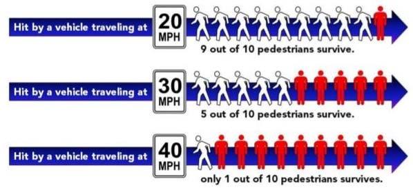
27 Pedestrian Experience Buffered bike lanes provide separation from vehicular traffic for the pedestrian. Crossing distances are reduced. Pedestrians only have to cross three lanes of vehicular traffic. Speed is the biggest factor in whether a pedestrian survives a crash. 27
28 Pedestrian Safety 28


29 Bay to Bay Blvd (Dale Mabry Hwy to Esperanza Ave) Typical Section Existing Proposed 29


30 Bay to Bay Blvd (Dale Mabry Hwy to Esperanza Ave) 30
31 Bay to Bay Blvd (Dale Mabry Hwy to Esperanza Ave) 31

32 Bay to Bay Blvd (Dale Mabry Hwy to Esperanza Ave) Dedicated left turn lanes at intersections increase efficiency. 32

 Typical Section")
33 Bay to Bay Blvd (Esperanza Ave to Bayshore Blvd.) Typical Section Existing Proposed 33
34 Bay to Bay Blvd (Esperanza Ave to Bayshore Blvd.) 34

35 Bay to Bay Blvd (Esperanza Ave to Bayshore Blvd.) Lengthened left turn lane at intersections increases efficiency. Based upon the recommendations of the traffic study, road diet and bike lanes are not proposed in this section. 35
36 Bay to Bay Blvd (Esperanza Ave to Bayshore Blvd.) 36
 Lane reconfiguration allows for new left turn lane at the Lee")
37 Bay to Bay Blvd (Esperanza Ave to Bayshore Blvd.) Lane reconfiguration allows for new left turn lane at the Lee Roy Selmon On Ramp 37
38 Bay to Bay Blvd (Esperanza Ave to Bayshore Blvd.) New Sidewalk proposed to close the gap. Proposed left turn lane for Ysabella Ave. 38
39 Bay to Bay Blvd (Esperanza Ave to Bayshore Blvd.) 39
40 Bay to Bay Blvd (Esperanza Ave to Bayshore Blvd.) Two lefts and one right. Better mobility for Bikes No more acceleration lane and merge on Bayshore Blvd. 40
 Northbound and southbound Bayshore Blvd traffic will now stop at the same time.")
41 Bay to Bay Blvd (Esperanza Ave to Bayshore Blvd.) Northbound and southbound Bayshore Blvd traffic will now stop at the same time. Simplifies the operation for pedestrians 41
42 Traffic Analysis Travel Speeds Manhattan Ave to Bayshore Blvd AM Peak Midday Peak PM Peak Eastbound Westbound Eastbound Westbound Eastbound Westbound Existing 16 MPH 16 MPH 19 MPH 19 MPH 14 MPH 16 MPH Future 15 MPH 16 MPH 20 MPH 18 MPH 15 MPH 15 MPH 42
43 Traffic Analysis Level of Service AM Peak Hour Midday Peak Hour PM Peak Hour Intersection Avg. Delay per Vehicle (sec.) Level of Service Avg. Delay per Vehicle (sec.) Level of Service Avg. Delay per Vehicle (sec.) Level of Service Existing Future Existing Future Existing Future Existing Future Existing Future Existing Future Dale Mabry Hwy 52.8 D 43.4 D 62.0 E Himes Ave 17.3 B 17.7 B 22.3 C Concordia Ave 17.6 B 2.8 A 3.7 A Esperanza Ave 15.1 B 13.6 B 28.0 C MacDill Ave 63.6 E 50.1 D 66.3 E Bayshore Blvd 44.7 D 23.2 C 43.5 D 43
44 Traffic Analysis Level of Service AM Peak Hour Midday Peak Hour PM Peak Hour Intersection Avg. Delay per Vehicle (sec.) Level of Service Avg. Delay per Vehicle (sec.) Level of Service Avg. Delay per Vehicle (sec.) Level of Service Existing Future Existing Future Existing Future Existing Future Existing Future Existing Future Dale Mabry Hwy D D D D E E Himes Ave B B B B C C Concordia Ave B B A A A A Esperanza Ave B B B B C C MacDill Ave E D D D E E Bayshore Blvd D C C B D C 44
45 Summary Current four lane section is inefficient. Major signalized intersections control capacity, not lane configuration between intersections. Addition of Center Turn Lane alone improves operational and safety benefits of corridor. Proposed changes do not diminish vehicular operations, but significantly improve safety and efficiency for pedestrians and cyclists. Proposed changes east of Esperanza Ave. will improve operations of those intersections by a full level of service. 45
46 Next Steps Two week comment period Friday, Feb. 23, 2018 City response to comment Friday, March 16,
47 Resources and Links Project Website: to bay FHWA Road Diet Information: uide/ a16074/fhwasa16074.pdf hwasa17021.pdf FHWA Videos: Case Studies: ies/ es/lane_conversion_report_ pdf Other Links: exactly is a road diet/379975/ m?id= _analysis_lyles.pdf 47
48 Contact Information City of Tampa Contact: Bernadette Corey Project Manager Transportation and Stormwater Services Department
LTAP Fact Sheet. Abuzz word among transportation professionals. Kansas. Smarter, Safer Roadways: Road Diets for Rural Communities.
 Spring 2009 Kansas LTAP Fact Sheet A Service of Kansas University Transportation Center for Road, Street & Bridge Agencies Smarter, Safer Roadways: Road Diets for Rural Communities By Mehrdad Givechi,
STANLEY STREET December 19, 2017
 STANLEY STREET December 19, 2017 Welcome Mike Wiza, Mayor Scott Beduhn, Director of Public Works Agenda 1. Introduction 2. Existing Roadway Conditions 3. Current Alternative Improvements 4. Summary of
Road Diets FDOT Process
 Florida Department of TRANSPORTATION Road Diets FDOT Process Humberto Castillero, PE, PTOE Roadway Design Office Purpose of Guide Develop a statewide lane elimination review process Balance state & local
Frequently Asked Questions
 Frequently Asked Questions Business US 190 in Copperas Cove From Avenue D to Constitution Drive What is access management? A. Access Management is a growing effort by government agencies to improve how
Pedestrian & Bicycle Safety Innovations & Applications
 Pedestrian & Bicycle Safety Innovations & Applications County Engineers Association of Maryland Spring, 2017 Conference May 25, 2017 George Branyan Pedestrian Program Coordinator District Department of
Complete Street Analysis of a Road Diet: Orange Grove Boulevard, Pasadena, CA
 Complete Street Analysis of a Road Diet: Orange Grove Boulevard, Pasadena, CA Aaron Elias, Bill Cisco Abstract As part of evaluating the feasibility of a road diet on Orange Grove Boulevard in Pasadena,
HIGHBURY AVENUE/HAMILTON ROAD INTERSECTION IMPROVEMENTS PUBLIC INFORMATION CENTRE 1 MAY 14, 2015
 HIGHBURY AVENUE/HAMILTON ROAD INTERSECTION IMPROVEMENTS Municipal Class Environmental Assessment PUBLIC INFORMATION CENTRE 1 MAY 14, 2015 ACCESSIBILITY Under the Accessibility Standards 2015 for Customer
Draft North Industrial Area-Wide Traffic Plan
 Summary of North Industrial and Hudson Bay Industrial Recommended Improvements Table 1. Summary of s Item Location 1 2 3 4 5 6 7 8 9 10 11 12 Millar Ave north of 51st St Super 8 Motel back lane 400 Block
DEPARTMENT OF ENVIRONMENTAL SERVICES. North Harrison Street (Lee Highway to Little Falls Road) Comparative Analysis. Prepared for:
 Comparative Analysis. Prepared for:") DEPARTMENT OF ENVIRONMENTAL SERVICES North Harrison Street (Lee Highway to Little Falls Road) Comparative Analysis Prepared for: Arlington County Department of Environmental Services 2100 Clarendon Boulevard,
DEPARTMENT OF ENVIRONMENTAL SERVICES North Harrison Street (Lee Highway to Little Falls Road) Comparative Analysis Prepared for: Arlington County Department of Environmental Services 2100 Clarendon Boulevard,
COWETA HIGH SCHOOL AND EAST HIGHWAY 51
 COWETA HIGH SCHOOL AND EAST HIGHWAY 51 Lack of sidewalks along Ben Lumpkin Rd. Lack of crosswalks and ramps at intersection. Hwy 51 is wide to cross as a pedestrian. No ADA compliance or connection to
Dr. M.L. King, Jr. Street North Complete Streets Resurfacing Opportunities HOUSING, LAND USE, AND TRANSPORTATION COMMITTEE MARCH 22, 2018
 Dr. M.L. King, Jr. Street North Complete Streets Resurfacing Opportunities HOUSING, LAND USE, AND TRANSPORTATION COMMITTEE MARCH 22, 2018 What s Happening The City plans to mill and resurface Dr. M.L.
City of Gainesville Transportation/Roadway Needs PROJECT SUMMARY
 A1 Roadway Resurfacing $23,846,000 TYPE: Preservation of existing system Roadway resurfacing A2 Signal Replacement $6,000,000 TYPE: Preservation of existing system Replace traffic signals. B1 W 6th St
DOWNTOWN TUPELO MAIN STREET: ROAD DIET STUDY
 DOWNTOWN TUPELO MAIN STREET: ROAD DIET STUDY Since mid-2009, RPM Transportation Consultants (RPM) has worked with the Downtown Tupelo Main Street Association to evaluate traffic conditions and potential
Clybourn Ave. Protected Bike Lane Study Halsted St. to Division St.
 Clybourn Ave. Protected Bike Lane Study Halsted St. to Division St. Nathan Roseberry, Senior Engineer Pam Broviak, Project Manager July 24, 2014 Agenda Project Goals Existing Roadway Conditions Traffic
J Street and Folsom Boulevard Lane Conversion Project (T ) Before and After Traffic Evaluation
 Before and After Traffic Evaluation") J Street and Folsom Boulevard Lane Conversion Project (T15125400) Before and After Traffic Evaluation Prepared by Transportation Division June 2014 Executive Summary On February 12, 2013, the City of Sacramento
J Street and Folsom Boulevard Lane Conversion Project (T15125400) Before and After Traffic Evaluation Prepared by Transportation Division June 2014 Executive Summary On February 12, 2013, the City of Sacramento
Overview. Illinois Bike Summit IDOT Complete Streets Policy Presentation. What is a Complete Street? And why build them? And why build them?
 Overview Illinois Bike Summit IDOT Complete Streets Policy Presentation Aren Kriks, P.E. District One Bicycle Coordinator and Bureau of Programming Project Engineer History of Complete Streets IDOT Policy
122 Avenue: 107 Street to Fort Road
 : 107 Street to Fort Road November 24, 2015 4:30 8:00 p.m. Meeting Purpose Summarize project work completed to date Share results of public input from Phase 1 Share the draft concept plan and proposed
CITY OF LOMITA CITY COUNCIL REPORT
 CITY OF LOMITA CITY COUNCIL REPORT TO: FROM: City Council Ryan Smoot, City Manager Item No. SCH 12 PREPARED BY: Mark A. McAvoy, P.E., Public Works Director/City Engineer MEETING DATE: August 1, 2017 SUBJECT:
CAPITOL DRIVE & FOND DU LAC AVENUE INTERSECTION ANALYSIS. Urban Planning 772 SARAH BREGANT, RYAN PETERSON, & MATT WERDERITCH
 CAPITOL DRIVE & FOND DU LAC AVENUE INTERSECTION ANALYSIS Urban Planning 772 SARAH BREGANT, RYAN PETERSON, & MATT WERDERITCH OVERVIEW N 51 ST BOULEVARD N 51 ST BOULEVARD 12,100 44,700 W CAPITOL DRIVE 52,600
COMMUNITY MEETING AGENDA
 COMMUNITY MEETING AGENDA Welcome and Introductions SAFE Presentation Project Presentation Priorities Feedback Next Steps Q&A Santa Cruz Avenue Corridor Study 1 Santa Cruz Avenue Corridor Study Community
Northbound San Jose Avenue & I-280 Off-Ramp Road Diet Pilot Project
 Project Overview Fed by a two-lane Interstate-280 (I-280) off-ramp, high vehicular volumes and speeds are longstanding issues along San Jose Avenue. Residents in the surrounding neighborhoods have expressed
Existing Conditions. Date: April 16 th, Dan Holderness; Coralville City Engineer Scott Larson; Coralville Assistant City Engineer
 Date: April 16 th, 2015 To: From: Re: Dan Holderness; Coralville City Engineer Scott Larson; Coralville Assistant City Engineer Darian Nagle-Gamm, Traffic Engineering Planner Highway 6 (2 nd Street) /
Thank you for attending
 Improving mobility safety comfort WELCOME Thank you for attending The purpose of this meeting is to: Learn about the project Prioritize potential walking and biking improvements on Snelling Ave Gather
CITY OF LOS ANGELES INTER-DEPARTMENTAL MEMORANDUM
 CITY OF LOS ANGELES INTER-DEPARTMENTAL MEMORANDUM Date: April 1, 219 To: Honorable City Council c/o City Clerk, Room 395, City Hall Attention: Honorable Mike Bonin, Chair, Transportation Committee From:
Dear Mr. Tweed: Sincerely, Min Zhou, P.E. Vice President
 December 17, 2012 Mr. Steve Tweed City of Long Beach, Department of Public Works Traffic & Transportation Bureau, 10 th Floor City Hall 333 West Ocean Boulevard Long Beach, CA 90802 Subject: Broadway and
BOARD OF COUNTY COMMISSIONERS AGENDA ITEM SUMMARY
 7B BOARD OF COUNTY COMMISSIONERS AGENDA ITEM SUMMARY PLACEMENT: REQUESTS AND PRESENTATIONS PRESET: TITLE: FLORIDA DEPARTMENT OF TRANSPORTATION (FDOT) PRESENTATION RECONSTRUCTION OF SR-76 (SW KANNER HIGHWAY)
Los Altos Hills Town Council - June 18, 2015 Palo Alto City Council June 22, AGENDA ITEM #2.B Presentation
 Los Altos Hills Town Council - June 18, 2015 Palo Alto City Council June 22, 2015 AGENDA ITEM #2.B Presentation Previous Presentations Los Altos Hills Town Council in May 2014 and February 2015 Palo Alto
Report. Typical Sections. City of Middleton, WI
 Report Typical Sections City of Middleton, WI December 2006 Report for City of Middleton, Wisconsin Typical Sections repared by: Traffic Associates LLC and STRAND ASSOCIATES, INC. 910 West Wingra Drive
Reference number /VP. Lafayette Downtown Congestion Study - Additional Traffic Analysis
 To James Hinkamp and Tony Coe, City of Lafayette Date January 19, 2017 Copies Reference number 243381/VP From Michael Iswalt and Vanessa Peers File reference 4-05 Subject Lafayette Downtown Congestion
TRANSPORTATION ANALYSIS REPORT US Route 6 Huron, Erie County, Ohio
 TRANSPORTATION ANALYSIS REPORT US Route 6 Huron, Erie County, Ohio December 12, 2012 Prepared for: The City of Huron 417 Main Huron, OH 44839 Providing Practical Experience Technical Excellence and Client
Project Description Form 8EE
 Project Description Form 8EE Basic Project Information Submitting Jurisdiction/Agency: Town of Dumfries Project Title: Route 1 (Fraley Blvd) Widening: Brady's Hill Road to Dumfries Road Project Location:
Project Goal and Description. Why Broadway? Broadway SFMTA.COM/BROADWAY. The goal of the Broadway Safety Improvement
 PROJECT OVERVIEW Project Goal and Description The goal of the Broadway Safety Improvement d St Van Ness Ave Project is to improve safety and comfort for all who Franklin St Hyde St Octavia St Gough St
MEMORANDUM. Charlotte Fleetwood, Transportation Planner
 MEMORANDUM Date: Updated August 22, 2017 To: Organization: Charlotte Fleetwood, Transportation Planner Boston Transportation Department From: Jason DeGray, P.E., PTOE, Regional Director of Engineering
Transportation Planning Division
 Transportation Planning Division Presentation Outline Study Tasks Recap of Previous Meetings Data Collected Focus Areas within Study Limits Design Principles Tool Box Recommended Concepts Schedule Moving
Road Diets A Proven Safety Countermeasure
 The Road Diet Cross Section Conversion: Information Guide Summary Efficiency through technology and collaboration Keith Knapp, Ph.D., P.E. Iowa LTAP (Thanks Project Team Member & FHWA!) Road Diets A Proven
Long Island Rail Road Expansion Project Floral Park to Hicksville
 Long Island Rail Road Expansion Project Floral Park to Hicksville Final Environmental Impact Statement Appendix 1-D Complete Streets Policy Checklist April 2017 0902ML PIN: Project Location: 18A-4 Floral
ACTIVE TRANSPORTATION
 ACTIVE TRANSPORTATION Mobility 2040 Supported Goals Improve the availability of transportation options for people and goods. Support travel efficiency measures and system enhancements targeted at congestion
Lincoln Avenue Road Diet Trial
 Lincoln Avenue Road Diet Trial Data Collection Report June 1, 2015 Department of Transportation Table of Contents I. Introduction...... 3 II. Data Collection Methodology & Results...... 5 A. Traffic Volume
Intersection Improvement: Sturgeon Road, Silver Avenue and Murray Park Road Roundabout. Welcome. Public Information Session
 Intersection Improvement: 1 Welcome WHY IS AN INTERSECTION IMPROVEMENT NEEDED? 2 Traffic volumes for Sturgeon Road, Silver Avenue and Murray Park Road exceed the capacity of the existing 4-way stop controlled
LANE ELIMINATION PROJECTS
 PRESENTATION OUTLINE Lane Elimination Considerations Districts 4 & 7 Draft Lane Elimination Processes FDOT Lane Elimination Guidelines Example Projects D4 Case Study: SR A1A (Ft. Lauderdale) D7 Case Study:
2015 Florida Main Street Annual Conference. Complete Streets Equal Stronger Main Streets
 WHAT ARE COMPLETE STREETS? CASE STUDIES COMPLETING YOUR MAIN STREET 2015 Florida Main Street Annual Conference St. Petersburg, Florida August 19, 2015 WHAT ARE COMPLETE STREETS? CASE STUDIES COMPLETING
Route 79/Davol Street Corridor Study
 Route 79/Davol Street Corridor Study Fall River, MA Public Information Meeting #2 November 21, 2013 Fall River Heritage State Park Fall River, MA Agenda Welcome and Introductions Overview of Study Process
FMATS Transportation Improvement Program Project Nomination Form
 FMATS 2015 2018 Transportation Improvement Program Project Nomination Form Project nominations are accepted from the public and are scored based on the adopted Project Scoring Criteria. These criteria
PEDESTRIAN SAFETY IMPROVEMENT EVALUATION GUIDELINE FOR UNCONTROLLED CROSSINGS
 PEDESTRIAN SAFETY IMPROVEMENT EVALUATION GUIDELINE FOR UNCONTROLLED CROSSINGS Traffic Safety Engineering Division Updated: April 2018 EXECUTIVE SUMMARY NDOT Traffic Safety Engineering Division developed
Route 7 Corridor Study
 Route 7 Corridor Study Executive Summary Study Area The following report analyzes a segment of the Virginia State Route 7 corridor. The corridor study area, spanning over 5 miles in length, is a multi
Potential Bicycle Facility on Bayou Street Mobile, Alabama
 Potential Bicycle Facility on Bayou Street Mobile, Alabama By Richard A. Hall, P.E. Prepared For Mobile Downtown Alliance Hall Planning & Engineering, Inc. March 28, 2018 Introduction Review of the February
Welcome! San Jose Avenue Open House August 25, 2015
 Welcome! San Jose Avenue Open House August 25, 2015 Vision Zero The City and County of San Francisco adopted Vision Zero San Francisco Vision Zero High Injury Network as a policy in 2014, committing an
Duwamish Way-finding and CTR Report
 V. North Tukwila When the North Tukwila Manufacturing and Industrial Center was designated in 1992 as part of the region s land use and transportation plan, the plan called for the area to set a light-rail
Lessons Learned from Cycle Tracks (Class IV Bikeways) Design Practice
 Design Practice") Lessons Learned from Cycle Tracks (Class IV Bikeways) Design Practice By: Min Zhou, P.E., Principal/Vice President KOA Corporation 1 What is a Cycle Track (Class IV) TYPICAL BIKEWAY CLASSIFICATION CLASS
Lessons Learned from Cycle Tracks (Class IV Bikeways) Design Practice By: Min Zhou, P.E., Principal/Vice President KOA Corporation 1 What is a Cycle Track (Class IV) TYPICAL BIKEWAY CLASSIFICATION CLASS
Washington St. Corridor Study
 FIGURE 7.17 Bridge Alternatives - Cross Sections 86 Discarded Alternative: Short-Term Bridge Repair Short-term repairs and west bridge span replacement were considered during analysis. Short-term repairs
Route 29 Solutions Projects
 Route 29 Solutions Route 29 Solutions Projects www.route29solutions.org October 10, 2014 Route 29 Widening to Six Lanes Albemarle County This project will widen a 1.8-mile segment of Route 29 from four
Boston Post Road Design Feasibility Study
 Boston Post Road Design Feasibility Study Prepared for the City of Rye Final Report July 18, 2007 Prepared by: Buckhurst Fish & Jacquemart (BFJ) 115 Fifth Avenue New York, NY 10003 www.bfjplanning.com
Blair/Williamson Intersection Expressed Needs
 Blair/Williamson Intersection Expressed Needs NORTH Blair Street is a barrier for pedestrians and bicycles Relocate Capitol City Trail crossing from Blair Street and John Nolen Drive intersection to Williamson
Vehicular turning and path of travel with a proposed curb bulb on the southwest corner of Mount Diablo Boulevard and Dewing Avenue.
 October 3, 2014 James Shively Stantec 100 California Street, Suite 1000, San Francisco CA 94111-4505 Subject: Traffic Study for Proposed Lafayette Chase Bank Dear Mr. Shively: Pursuant to your request,
East 12 th Street Bikeway Feasibility Study
 Final Report East 12 th Street Bikeway Feasibility Study Prepared for: City of Oakland Public Works Agency Submitted by: 180 Grand Avenue, Suite 250 Oakland, CA 94612 Phone: (510) 839-1742; Fax: (510)
Pine Hills Road Pedestrian/Bicycle Safety Study Board of County Commissioners Work Session
 Pine Hills Road Pedestrian/Bicycle Safety Study Board of County Commissioners Work Session February 20, 2018 Meeting Agenda Study Overview Existing Conditions Access Management Potential Gateway Features
US 301 Resurfacing, Restoration, and Rehabilitation
 US 301 Resurfacing, Restoration, and Rehabilitation From Pond Ave to North of Pioneer Museum Rd/Long Ave Pasco County, FL Work Program Item No. 429075-2 Project Overview Project Location: POND AVE WHITEHOUSE
Summary: Mercer County Princeton Avenue & Spruce Street Study January 2009
 Summary: Several recent studies have assessed potential development and redevelopment opportunities in the Mercer Crossing area of Trenton, Ewing, and Lawrence. This Princeton Avenue and Spruce Street
Station 1: Street & Sidewalk Upgrades
 Station 1: Street & Sidewalk Upgrades Existing no left turn; Potential left turn arrow, see Circulation Study boards for more information Thru-lane guidance Improved lead-in green bike lane 17TH ST CASTRO
Pedestrian Road Safety Audit
 Pedestrian Road Safety Audit Middlebrook Road From Father Hurley Boulevard to Waring Station Road December 2017 Montgomery County Department of Transportation Table of Contents 1. Introduction... 1 1.1
City of Seattle Edward B. Murray, Mayor
 City of Seattle Edward B. Murray, Mayor Department of Transportation Scott Kubly, Director Eastlake Community Council 117 E Louisa St. #1 Seattle, WA 98102-3278 January 28, 2016 RE: Roosevelt to Downtown
Ottawa Beach Road Study
 Ottawa Beach Road Study Prepared For: Park Township September 30, 2014 Project No. G140303 OTTAWA BEACH ROAD STUDY PREPARED FOR: PARK TOWNSHIP SEPTEMBER 30, 2014 PROJECT NO. G140303 TABLE OF CONTENTS 1.0
Welcome. If you have any questions or comments on the project, please contact:
 Welcome This drop-in public open house is intended to provide information about the Bay Street bike lanes project. This project proposes a dedicated cycling facility along Bay Street between Aberdeen Avenue
Feasibility Study of Pedestrian Crossings Along Route 7, East of Cascades Parkway and West of Dranesville Road. October 3, 2017
 Feasibility Study of Pedestrian Crossings Along Route 7, East of Cascades Parkway and West of Dranesville Road October 3, 2017 Study Area (area within a ¼-mile radius of the study intersections) Route
Road Diets. Presented by: Cristine Gowland, P.E. LADOTD District 62 March 2, 2016
 Road Diets Presented by: Cristine Gowland, P.E. LADOTD District 62 March 2, 2016 FHWA s 9 Proven Safety Countermeasures 1. Safety Edge 2. Roundabouts 3. Corridor Access Management 4. Backplates with Retroreflective
Completing the Street: Denning Drive
 Completing the Street: Denning Drive Public Workshop and Walking Audit Winter Park Civic Center May 12, 2016 Completing the Street What Makes This a Complete Street? Completing the Street Complete Streets
What Is a Complete Street?
 Session 5 Charleen Zimmer, AICP, Zan Associates May 5-7, 2010 What Is a Complete Street? May 2010 5-1 Not a Complete Street More of a Complete Street May 2010 5-2 Benefits of Complete Streets Safety for
Bellevue Downtown Association Downtown Bike Series
 Bellevue Downtown Association Downtown Bike Series Meeting 2 Franz Loewenherz Andreas Piller Kyle Potuzak Chris Long October 26, 2017 Today s Agenda: 1) Meeting Purpose 2) 9/28 Meeting Recap 3) Candidate
Public Works Committee Meeting Richard E. Mastrangelo Council Chamber November 20, 2017
 Public Works Committee Meeting Richard E. Mastrangelo Council Chamber November 20, 2017 Purpose of Meeting Why are we here? Project Recap/Updates Project Limits/Segments Road Diet Concept Lessons Learned
REPORT CONCURRENCE. City Manager. The General Manager concurs with the recommendation of this report.
 COUNCIL REPORT Report No. ENG 08-018 Executive Committee Date: May 0, 018 File No: 5400-1 To: From: Subject: Mayor and Council Purvez Irani, Senior Transportation Engineer Bluejay Street Road Improvements
Complete Streets Policy DAVID CRONIN, P.E., CITY ENGINEER
 Complete Streets Policy DAVID CRONIN, P.E., CITY ENGINEER Complete Streets City Commission adopted a Complete Streets policy in 2012 Complete Streets are road networks that are designed for all users:
Harbord Street and Hoskin Avenue Bicycle Lane Upgrades
 STAFF REPORT ACTION REQUIRED and Bicycle Lane Upgrades Date: April 22, 2014 To: From: Wards: Reference Number: Public Works and Infrastructure Committee General Manager, Transportation Services 19 and
INNOVATIVE INTERSECTION DESIGN
 INNOVATIVE INTERSECTION DESIGN J. Eddie Valtier, P.E. ELP TP&D Director Introduction Why Do We Need To Start Looking For Innovative Intersection Designs? Congestion is worsening and traffic volumes and
Summary of Comments Public Meeting: Marietta Street Resurfacing Project Atlanta Contemporary August 29, 2017 / 6:00 pm to 8:00 pm
 Renew Atlanta hosted a public meeting to discuss the Marietta Street Resurfacing project at. Councilmember Cleta Winslow attended the public meeting, where over seventy (70) citizens to include representatives
Board of Supervisors February 27, 2017
 : Traffic Analysis Results & Draft Conceptual Plan Board of Supervisors February 27, 2017 Transportation Solutions Building Better Communities Presentation Overview Background Summary of Traffic Analysis
Off-road Trails. Guidance
 Off-road Trails Off-road trails are shared use paths located on an independent alignment that provide two-way travel for people walking, bicycling, and other non-motorized users. Trails specifically along
1 st and 2 nd Street Couplet FAQ s
 1 st and 2 nd Street Couplet FAQ s Q. Will the proposed roundabout at Flume/2nd/1 st Streets affect access to businesses nearby?... 2 Q. What if the project isn t received well by the community after construction?...
Arlington Public Schools Thomas Jefferson Site Evaluation Transportation Networks. Thomas Jefferson Working Group Meeting #6 November 10, 2014
 Arlington Public Schools Thomas Jefferson Site Evaluation Transportation Networks Thomas Jefferson Working Group Meeting #6 November 10, 2014 2 3 INTRODUCTION 4 Goal of our work: Identify and assess multi-modal
Preliminary Transportation Analysis
 Preliminary Transportation Analysis Goals of a Robust, Multimodal Transportation Network Safe Accessible/Connected Efficient Comfortable Context-Sensitive Motor Vehicle: Continue to analyze the data to
Road Diets: Reconfiguring Streets for Multi-Modal Travel
 Road Diets: Reconfiguring Streets for Multi-Modal Travel Tom Grant, P.E., PTOE What is a Road Diet? Reconfiguration of travel lanes to benefit all roadway users (i.e., Complete Street) Reclaiming the space
In November 2015, the City of Bellingham, WA, USA completed $4.3 million in safety
 CASE STUDY C-Curb Your Enthusiasm: By Chris Comeau, AICP-CTP and Chris Breiland In November 2015, the City of Bellingham, WA, USA completed $4.3 million in safety improvements on Alabama Street using the
Environmental Assessment Findings & Recommendations. Public Hearing November 13, 2014
 Environmental Assessment Findings & Recommendations Public Hearing November 13, 2014 Welcome! Welcome and Introductions Project and Environmental Assessment Overview Public Comments Adjourn Purpose of
This page intentionally left blank.
 This page intentionally left blank. COMMUNITY Coweta Community Overview Coweta Coweta, a residential community located in Wagoner County, is a suburb of Tulsa situated southeast of the metropolitan area
RM 620 FEASIBILITY STUDY
 RM 620 FEASIBILITY STUDY Sections 5 & 6 December 7, 2015 STUDY PROCESS Study Purpose and Goals The RM 620 Feasibility Study was launched by the Texas Department of Transportation (TxDOT) to analyze transportation
Access Management in the Vicinity of Intersections
 Access Management in the Vicinity of Intersections FHWA-SA-10-002 Technical Summary Photo: Ralph Bentley (used with permission) 0 Access Management is: The design, implementation and management of entry
Raymond Avenue: Rightsizing Improved Safety and Pedestrian Experience
 Page 1 of 5 Work With Us Free Newsletter Stay Connected Home About Services Training Projects Placemaking Blog Resources Reference Store Great Public Spaces Image Collection Raymond Avenue: Rightsizing
WELCOME Public Information Centre
 WELCOME Public Information Centre Fernforest Drive Brampton Soccer Centre Community Room #2 Tuesday January 19, 2016 6:30 p.m.to 9:00 p.m. Please sign in Neighbourhood Traffic Calming Guide Background
SAN FRANCISCO MUNICIPAL TRANSPORTATION AGENCY
 THIS PRINT COVERS CALENDAR ITEM NO.: 10.3 DIVISION: Sustainable Streets BRIEF DESCRIPTION: SAN FRANCISCO MUNICIPAL TRANSPORTATION AGENCY Approving various traffic and parking modifications on Bay Street
Public Information Centre
 WELCOME Public Information Centre Father Tobin Road Lougheed Middle School - Library Wednesday November 7, 2012 7:00 p.m.to 9:00 p.m. Please sign in Neighbourhood Traffic Calming Guide Background The City
Appendix C. NORTH METRO STATION AREA TRAFFIC IMPACT STATEMENT 88th Avenue Station
 Appendix C NORTH METRO STATION AREA TRAFFIC IMPACT STATEMENT 88th Avenue Station Prepared for: Regional Transportation Department and URS Corporation as part of the North Metro EIS David Evans and Associates,
DRAFT - CITY OF MEDFORD TRANSPORTATION SYSTEM PLAN Roadway Cross-Sections
 Roadway Cross-Sections Medford s roadway cross-section standards apply to new and reconstructed roads. The crosssections take into consideration roadway function and operational characteristics, including
Chapter 2: Standards for Access, Non-Motorized, and Transit
 Standards for Access, Non-Motorized, and Transit Chapter 2: Standards for Access, Non-Motorized, and Transit The Washtenaw County Access Management Plan was developed based on the analysis of existing
US 41 COMPLETE STREETS CORRIDOR PLANNING STUDY from University Parkway to Whitfield Avenue
 41 US 41 COMPLETE STREETS CORRIDOR PLANNING STUDY from University Parkway to Whitfield Avenue EXECUTIVE SUMMARY DRAFT FEBRUARY 2019 Project Overview The US 41 Complete Streets Corridor Planning Study,
APPENDIX A: Complete Streets Checklist DRAFT NOVEMBER 2016
 APPENDIX A: Complete Streets Checklist DRAFT NOVEMBER 2016 Complete Streets Checklist MetroPlan Orlando s Complete Streets Checklist is an internal planning tool for staff to further implementation of
PEDESTRIAN ACCOMMODATIONS DPS 201 AT INTERCHANGES
 PEDESTRIAN ACCOMMODATIONS DPS 201 AT INTERCHANGES UNDERSTANDING THE ISSUES Intersections of freeway ramp terminals at crossroads are the most critical components of an interchange Challenge: balance mobility
Evaluation of M-99 (Broad Street) Road Diet and Intersection Operational Investigation
 Road Diet and Intersection Operational Investigation") Evaluation of M-99 (Broad Street) Road Diet and Intersection Operational Investigation City of Hillsdale, Hillsdale County, Michigan June 16, 2016 Final Report Prepared for City of Hillsdale 97 North Broad
Evaluation of M-99 (Broad Street) Road Diet and Intersection Operational Investigation City of Hillsdale, Hillsdale County, Michigan June 16, 2016 Final Report Prepared for City of Hillsdale 97 North Broad
Designing Complete Streets: What you need to know
 Designing Complete Streets: What you need to know Getting from this to this. Continuous sidewalk Buffer w/trees Bicycle lane Raised median Buildings close to the street Flexibility in design Design and
Coquitlam Cross-town Bike Route Improving Bicycle Facilities in a Mature Suburban Environment
 Coquitlam Cross-town Bike Route Improving Bicycle Facilities in a Mature Suburban Environment Sarah Rocchi, Vice-President, Projects, Opus International Consultants (Main Presenter) Catherine Mohoruk,
JONESBORO HIGHWAY 63 HIGHWAY 18 CONNECTOR STUDY
 JONESBORO HIGHWAY 63 HIGHWAY 18 CONNECTOR STUDY Craighead County May 2007 JONESBORO HIGHWAY 63 HIGHWAY 18 CONNECTOR STUDY Craighead County May 2007 Prepared by Planning and Research Division Arkansas State
Gandy Connector: Travel Demand. Policy Committee August 2013
 Gandy Connector: Travel Demand Policy Committee August 2013 What options to the Gandy Elevated Lanes exist? What are the current conditions? Who s using Gandy Blvd? What s currently planned? What s been