Tonight is an opportunity to learn about the Study and ask questions of the Study Team members.
|
|
|
- Wendy Palmer
- 5 years ago
- Views:
Transcription

1 Exhibit 1 Welcome Second Open House Tonight is an opportunity to learn about the Study and ask questions of the Study Team members. A first Public Open House was held on September 18th, 2013 which presented the Preliminary Preferred Solution for Carp Road to be a Four Lane Road Renewal. That Solution has since been confirmed by the Study Team. Tonight we are seeking your comments on the work undertaken since the 1st Public Open House: Alternative Design Development Evaluation of Alternative Designs Preliminary Preferred Design Please identify any issues and concerns that you would like to see addressed during the Study.
 identifies the need for widening of Carp Road between Highway 417 and Hazeldean Road as a Phase 2 project (2020-2025).")
2 Exhibit 2 Overview and Study Purpose The City of Ottawa initiated a Class Environmental Assessment Study (Schedule "C" project) for the widening of Carp Road between Highway 417 and Hazeldean Road. The City's 2013 Transportation Master Plan (TMP) identifies the need for widening of Carp Road between Highway 417 and Hazeldean Road as a Phase 2 project ( ). The widening has been identified to address growing vehicle/traffic demand in the western portion of the Kanata-Stittsville Area.


3 Exhibit 3 Environmental Assessment Process The Environmental Assessment process consists of five phases and is structured so that each phase builds on the previous one.
4 Exhibit 4 Study Schedule The following are key dates in the study schedule.
5 Exhibit 5 Consultation Activities The success of this Study will be largely dependent on the understanding and endorsement of the stakeholders involved. Key partners/stakeholders include landowners, business and community associations, institutions, utility companies, regulatory agencies and city departments. Consultation Groups Three Consultation Groups have been created to assist the City in advancing the study process meeting at key decision points in the study and include an Agency, Business, and Public Consultation Group. First Nation Consultation Consultation with First Nations will be achieved throughout the Study by communications with their identified representative(s). Special Stakeholder Meetings Special stakeholder meetings can be held which could be with individual landowners, community associations, local institutions, regulatory agencies, etc. where specific questions/issues arise. General Public Involvement Every person who has an interest in the Study will be given the opportunity to learn and participate in the Study through open houses (like tonight), or visiting the City s website. Master Mailing List All persons or organizations that express an interest in the Study may be added to the project mailing list and will receive information about the Study as it progresses.
6 Exhibit 6 Project Need and Opportunities The findings and conclusions in regards to the need and opportunity for a renewed Carp Road from Hwy 417 to Hazeldean Road are as follows: Based on the planned development within the Carp Road capture area, approximately 2,600 and 3,800 new two-way vehicle trips are projected on Carp Road during the weekday morning and afternoon peak hours, respectively; With respect to the projected peak hour and average peak period volumes based on the planned development within the vicinity of Carp Road, the widening of Carp Road from two lanes to four lanes is required; The analyses take into account the City's TMP and the significant new roadway capacity and mass transit that is planned in Stittsville and Kanata West areas. Notwithstanding that planned infrastructure and shifts in travel behaviour are anticipated, the widening of Carp Road from two to four lanes is needed; There exists some traffic movements and safety considerations that warrant the need to improve traffic operations on Carp Road that can be best addressed with a four lane roadway; There is an opportunity to provide pedestrian and cycling facilities on Carp Road in accordance with the current policy direction of the City's Official Plan and Transportation Master Plan; and There is an opportunity to improve the visual environment and functionality of Carp Road to provide a more pleasing entrance to Stittsville and to encourage new development and redevelopment on lands adjacent to it.
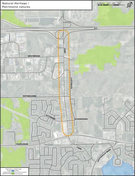
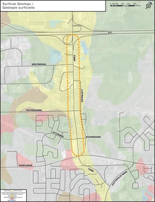
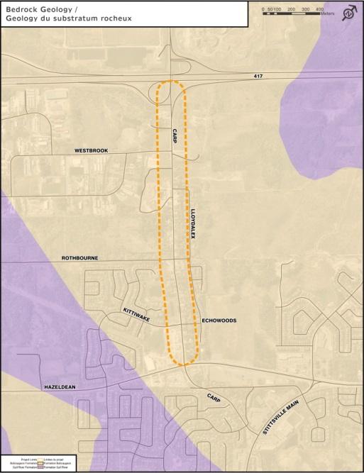
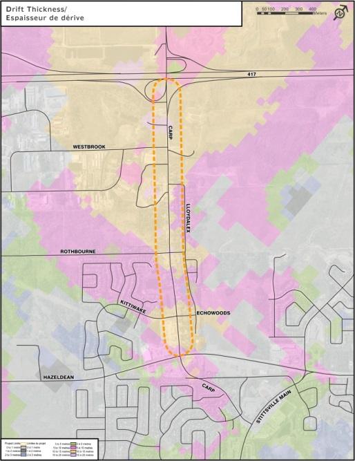
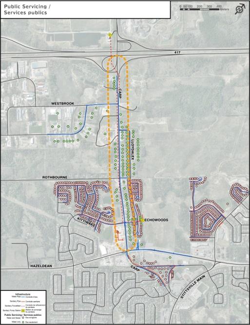
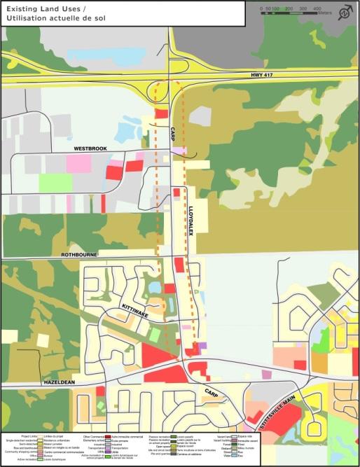
7 Exhibit 7 Existing Conditions Existing conditions are inventoried at the onset of all Environmental Assessment studies so that the potential effects of alternatives for the study can be assessed. This information will be updated progressively as investigations continue and additional information becomes available. Information on all aspects of the environment was collected and analysed in order to: Provide an understanding of existing conditions; Allow for future predictions of how the proposed project may cause environmental conditions to change; Allow for future predictions of how adverse effects can be mitigated and beneficial effects enhanced; and Provide a basis for designing monitoring programs. The following key environmental conditions have been determined at this time. Key factors include: The existing Right-of-Way (land owned by the City) throughout the corridor is far less than what is protected for in the City Official Plan (37.5 metres whereas between 22.0 to 30.0 metres exist today); There are many individual property accesses along Carp Road; There are concerns regarding traffic congestion and safety along the corridor; There is an absence of pedestrian and cycling facilities along the corridor; There is great potential for intensification and development along Carp Road and in adjacent employment areas and developing communities; and There are very few natural heritage features existing within the corridor.
8 Exhibit 7a Existing Transportation Conditions Pedestrians Sidewalks currently only exist between Hazeldean Road and Kittiwake Drive on the west side of the roadway. Pedestrians are presently accommodated on unpaved shoulders throughout the remainder of the corridor. Cyclists On-road bike lanes only exist between Hazeldean Road and Kittiwake Drive in the southbound direction. Cyclists are permitted to share the road with motor vehicles throughout the remainder of the corridor including heavy trucks. Transit Transit service in the corridor is provided by two local bus routes #203 and #262. An approximately 115 space minor Park and Ride facility is located at the intersection of Carp Road Westbrook Road. Motor Vehicles Carp Road currently carries peak directional volumes of up to approximately 1,200 veh/h during the weekday morning and afternoon peak hours. This peak hour volume exceeds the theoretical directional capacity of a 2-lane facility of approximately 800-1,000 veh/h. There are also known operational issues within the Corridor, including queuing and delays. There are current identified safety risks along the corridor including, slip-around movements using unpaved shoulders to avoid left-turning vehicles/delays at driveways and at intersections. This dangerous manoeuver is due to a lack of auxiliary turns lanes and where left-turn movements are not prohibited by a median barrier.

9 Exhibit 7b Existing Conditions

10 Exhibit 7c Existing Conditions

11 Exhibit 7d Existing Conditions
12 Exhibit 8 Evaluation of Alternative Solutions The Study Team identified the broadest range of possible solutions for Carp Road subject to a screening process. Alternatives that did not meet the needs and opportunities identified for the project were eliminated which included Localized Improvements, Two-Lane Renewal (with turn- lanes), and Reversible Lanes. Three alternative solutions were subject to further evaluation including: Do Nothing (baseline condition) Two-Lane Carp Road and New Parallel Road Four-Lane Road Renewal The impact-based analysis ranked each alternative from highest to lowest for a number of criterion used to evaluate the Transportation, Social, Natural, Physical and Economic Environments. The Preliminary Preferred Solution presented at the 1st Open House reconfirmed the City s 2013 Transportation Master Plan s recommendation for a Four Lane Renewal of Carp Road. Comments received at the 1st Open House can be generalized into the following categories: Roadway division (medians) and property access Property impacts Construction and timing considerations Widening was identified most often as the Preferred Solution.
13 Exhibit 9 Confirming the Preferred Solution for Carp Road Comments received from the consultation groups and the public were used to inform the Study and a Four-Lane Renewal was selected as the Preferred Solution for Carp Road for the following reasons: Meets future transportation infrastructure requirements in the area Provides for walking and cycling in the corridor Provides a good opportunity to enhance visual character and Enables long-term development and redevelopment in Stittsville area.
14 Exhibit 10 Carp Road Widening Design Principles Given the project need, opportunities and understanding of study area conditions, the following principles provided guidance to the identification and evaluation of alternative designs Future Capability A preferred design will anticipate the long-term economic growth of Stittsville s residential and employment areas, and provide appropriate transportation capacity to service travel needs. Mobility A preferred design will provide for all travel modes along and across the corridor, including walking, cycling, bus transit, passenger and heavy vehicles. Property Implications A preferred design will have the most efficient and compact footprint possible, while providing for transportation needs, in an effort to minimize effects on adjacent private properties (front yards, parking areas, etc) and to minimize the cost of land acquisition. Site Access A preferred design will provide vehicle access to adjacent properties, recognizing the need for median barrier separation associated with travel speeds and volumes. Greening A preferred design will improve the visual environment within the right-of-way, providing suitable space and setbacks to support healthy trees, grass, and other low maintenance plantings. Flexibility A preferred design will provide for some flexibility in implementation, possibly including a phased construction that corresponds to growing travel demands over the planning period.
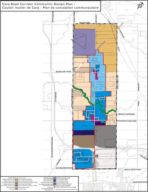
15 Exhibit 11 Alternative Designs Cross-Section Development Various considerations are regarded in the development and evaluation of alternative designs which include: What provisions are made for pedestrians? Are cyclists accommodated on-road or off-road? By what means are intersections controlled? What measures are used to manage turning movements and access to properties? How and where can the street be greened? City policies contained in the City of Ottawa Official Plan and Transportation Master Plan, Ottawa Cycling Plan, Ottawa, Pedestrian Plan, and Regional Road Corridor Design Guidelines. Regard for the Carp Road Corridor Community Design Plan. The following characteristics and components are common to all designs: Four travel lanes to urban standards Streetscaping elements (street lights, landscaping, etc.) in keeping with the road s designation as an Arterial Road Walking and cycling facilities along both sides of the corridor (Except North of Westbrook where these are provided on the west side only) Providing controlled intersections at Westbrook, Rothbourne, Kittiwake, and future protection for controlled access at Lloydalex and Maintaining signalization of the Hazeldean Road/Carp Road intersection. The historical centreline has been maintained through the majority of the corridor. A small centreline shift just north and south of Rothbourne Road was designed to manage front yard disruptions on either side of the corridor.

16 Exhibit 12 Alternative Designs Common Design North End The vehicle lane arrangement/boulevard treatment is constant for all alternative designs north of Westbrook Road and within the Ministry of Transportation s controlled access highway limits and includes: Four travel lanes A multi-use pathway to be provided on the west side of Carp Road and Turning restrictions/prohibitions to/from properties. It is important to note that the draft design within Ministry of Transportation s (MTO) controlled access highway limits will require approval by MTO.
 at the Carp/Hazeldean intersection One south-bound through-lane through the intersection Dedicated on-road cycling facility")
17 Exhibit 13 Alternative Designs Common Design South End The vehicle lane arrangement/boulevard treatment is also constant south of Kittiwake and includes the following characteristics: Four travel lanes Provision for an additional southbound left-turn lane (double left) at the Carp/Hazeldean intersection One south-bound through-lane through the intersection Dedicated on-road cycling facility and parallel pedestrian facility within the boulevard on the west side of the road and Multi-Use Pathway on the east side of the road.
18 Exhibit 14 Alternative Design #1 Signalized Intersections, On-Road Cycling Facility, Two-Way Left-Turn Lane Alternative Design #1 includes the following characteristics: Intersection signalization at Westbrook Road, Rothbourne Road, Kittiwake Drive/Echowoods Avenue and future protection for Lloydalex Crescent On-Road Bike Lanes Boulevard area on both sides of the road used to accommodate a sidewalk and landscaping elements, room for snow storage and utilities Centre-lane designed as a two-way left-lane in short-term, full barrier median in the long term and Typical corridor width is metres between intersections.
19 Exhibit 15 Alternative Design #2 Signalized Intersections, Off-Road Cycling, Two-Way Left-Turn Lane Alternative Design #2 includes the following characteristics: Intersection signalization at Westbrook Road, Rothbourne Road, Kittiwake Drive/Echowoods Avenue and future protection for Lloydalex Crescent Off-road cycling facility as either a Cycle Track or Multi-Use Pathway Boulevard area on both sides of the road used for off-road cycling facility/sidewalk and landscaping elements, room for snow storage and utilities Centre-lane designed as a two-way left-lane in short-term, full barrier median in the long term and Typical corridor width is metres between intersections.
20 Exhibit 16 Alternative Design 3 Roundabout Intersections, on-road Cycling, Narrow median Alternative Design #3 includes the following characteristics: Roundabouts at Westbrook Road, Rothbourne Road, Kittiwake Drive/Echowoods Avenue and future protection for Lloydalex Crescent 1.5 m narrow median in constrained sections On-road cycling facility Boulevard area on both sides of the road used to accommodate a sidewalk and landscaping elements, room for snow storage and utilities Installation of a raised median at varying widths to minimize impact on adjacent properties and Typical corridor width is to metres between intersections.
21 Exhibit 17 Alternative Design 4 Roundabout Intersections, Off-Road Cycling,.Narrow median Alternative Design #4 includes the following characteristics: Roundabouts at Westbrook Road, Rothbourne Road, Kittiwake Drive/Echowoods Avenue and future protection for Lloydalex Crescent 1.5 m narrow median in constrained sections Off-road cycling facility as a Cycle Track or Multi-Use Pathway Boulevard area on both sides of the road used for off-road cycling facility/sidewalk and landscaping elements, room for snow storage and utilities Installation of a raised median with varying widths to minimize impact on adjacent properties and Typical corridor width is to metres between intersections.
22 Exhibit 18 Alternative Design 5 Roundabout Intersections, on-road Cycling, Wide median Alternative Design #5 includes the following characteristics: Roundabouts at Westbrook Road, Rothbourne Road, Kittiwake Drive/Echowoods Avenue and future protection for Lloydalex Crescent 5.0 m wide median in most sections On-road cycling facility Boulevard area on both sides of the road used for sidewalk, landscaping elements, room for snow storage and utilities Installation of a raised green median throughout the corridor and Typical corridor width is metres between intersections.
23 Exhibit 19 Alternative Design 6 Roundabout Intersections, Off-Road Cycling,.Wide median Alternative Design #6 includes the following characteristics: Roundabouts at Westbrook Road, Rothbourne Road, Kittiwake Drive/Echowoods Avenue and future protection for Lloydalex Crescent 5.0 m wide median in most sections Off-road cycling facility as a Cycle Track or Multi-Use Pathway Boulevard area on both sides of the road used for off-road cycling facility/sidewalk and landscaping elements, room for snow storage and utilities Installation of a raised green median throughout the corridor and Typical corridor width is metres between intersections.
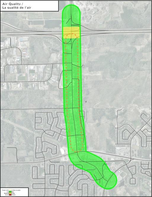
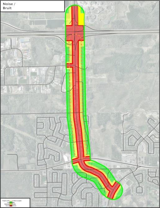
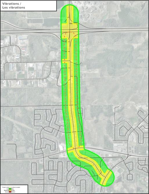
24 Exhibit 21 Evaluation Criteria and Methodology Three (3) broad groups of criteria were used to analyze the suitability of each alternative design including Socio- Economic, Transportation, and Biophysical Environments. The following 18 criteria, which includes 39 indicators were used in the evaluation. Socio-Economic Environment Corridor Land Use and Access Land Implications Building Implications Visual Environment Sustainable Landscaping Community Heritage Noise Vibration Outdoor Air Quality Life Cycle Costs Transportation Environment Pedestrian Convenience, Comfort and Safety Cycling Convenience, Comfort and Safety Universal Accessibility Bus Transit Time and Reliability Motor Vehicle Safety and Performance Biophysical Environment Terrestrial Habitat and Species Surface Water and Aquatic Habitat Impacted Materials An evaluation Matrix was used to evaluate the performance of each of the alternative designs giving consideration to project complexity, community interests and the use of a defensible and traceable process.


25 Exhibit 22 Evaluation Scale To assist in understanding how the evaluation was conducted the following table details the evaluation scale used. Each design was evaluated on how it performs in meeting each individual indicator ranging from performing very well to failure. The performance was evaluated against its achievement of best design practices, benchmarks, regulatory standards, or values expressed by stakeholders and in policy and guidelines.
 are preferred over the two-way left-turn lane alternatives (1 and 2) which in the long-term would: Provide more access limitations")
26 Exhibit 23 Evaluation Results As a general trend, alternatives that provide for off-road cycling facilities were favoured those being Alternatives 2, 4, and 6. As well, alternatives providing roundabouts (Alternatives 4 and 6) are preferred over the two-way left-turn lane alternatives (1 and 2) which in the long-term would: Provide more access limitations in the long-term (May require long-term reconstruction to install a centre median); Consume a wider ROW; Have a greater capital construction cost; and Result in a poor visual environment. The two most preferred alternatives (4 and 6), employ roundabouts with off-road cycling. The distinction is the width of the median barrier Alternative 4 employs a narrow 1.5 m median (lesser ROW, reduced property impacts); whereas Alternative 6 employs a wide 5.0 m median (greater ROW, more impacts), but greener visual environment.

27 Exhibit 24 Preliminary Preferred Design Alternative 4 (Roundabouts, Off-Road Cycling, Narrow Median) is being recommended as the Preliminary Preferred Design as it achieves The highest average performance across all indicators. The highest average performance of indicators within criteria groups Socio-Economic, Transportation, and Biophysical. The Preliminary Preferred Design responds to the study design principles in the following ways Future Capability: Ample capacity to address long term needs for the long term: Mobility: Provides well for all modes, including active transportation Property Implications: Narrowest Right-of-Way requirements, minimizes number of properties impacted Site Access: Maximizes property access from both directions, for all modes Greening: Provides for greening along the road edge where its benefits are greatest Flexibility: The ultimate solution is constructed at day one, to serve long-term needs

28 Exhibit 26 The Benefits of Roundabouts What is a Roundabout? Roundabouts are a type of intersection at which all traffic circulates in a counterclockwise direction, to the right of a central island. All entering vehicles must yield to traffic already in the roundabout What are the Benefits of Roundabouts? Roundabouts have a number of benefits over traditional intersections including Improved Safety Reducing the number of vehicle conflict points and reducing vehicular speeds, in turn, reduces the potential for severe crashes and serious injury. Reduced Speeds A reduction in speed is necessary to negotiate the roundabout, whereas vehicles may not slow down during the green phase of a traffic signal. Increased Capacity A high volume of left turning vehicles is better handled by a roundabout than a multi-phased traffic signal. Fewer Stops and Reduced Delays Delay is significantly reduced by yielding at the entry of a roundabout, rather than stopping and waiting for a green light at a signalized intersection; or waiting for a gap in the traffic at a stop sign. Less Idling and Air Pollution Reduced delays mean reduced fuel consumption and improved air quality by reducing emissions. Reduced Maintenance Costs The roundabout eliminates maintenance and electricity costs associated with traffic signals. Aesthetically Pleasing There is an opportunity for landscaping within the central island. Source MTO, 2014,
29 Exhibit 27 The Benefits of a Multi-Use Pathways The Preliminary Preferred Design includes multi-use pathways along each side of the corridor. The benefits include: Providing a walking route, in each direction, along both sides of the corridor Providing a cycling route, in each direction, along both sides of the corridor Separating cyclists from vehicles, by a curb and a landscaped boulevard in most situations and Economizing on space, where pedestrian and cyclist mobility is provided on a 3m wide facility, thereby reducing land impacts and acquisition requirements. Also, when bundled with roundabouts, cyclists can cross side streets in both directions across "cross rides", thereby avoiding the need to dismount and walk. Cycle tracks are less-favoured with the Preliminary Preferred design because they are relatively narrow surfaces and cycling can only occur in one direction along the side of the corridor. Multi-use pathways enable bi-directional cycling, thereby increasing flexibility in route choices and decreasing trip lengths.
30 Exhibit 28 Next Steps Following this Public Open House Your comments on the work-to-date will be reviewed along with input received from the Consultation Groups and a Preferred Design will be confirmed. The Consultation Groups will continue to provide review and feedback through the Functional Design process leading to a Recommended Plan. The Recommended Plan (Functional Design) and its impact assessment will be presented at a third Public Open House to be held in Spring Information about the project will continue to be posted on the City s website as it becomes available. Please continue to identify any issues and concerns that you would like see addressed during the study. Please fill out a Comment-Questionnaire. Leave it in the box provided, or return it to us by fax or mail by 12 March, Comments can also be submitted by to Jabbar.Siddique@ottawa.ca Additional information on the project can be found on the City s Website at Your views and contributions are important to the success of this Study!
TRANSPORTATION NEEDS ASSESSMENT
 TRANSPORTATION NEEDS ASSESSMENT A travel demand analysis was carried out to determine the operational issues and the potential benefit that adding traffic capacity would have on the road network. All the
WELCOME TO OPEN HOUSE # 1 June 14, 2017
 Langstaff Road Weston Road to Highway 7 Class Environmental Assessment Study WELCOME TO OPEN HOUSE # 1 June 14, 2017 Please sign in and join our mailing list Purpose of Open House #1 & Study Area York
Intersection Improvement: Sturgeon Road, Silver Avenue and Murray Park Road Roundabout. Welcome. Public Information Session
 Intersection Improvement: 1 Welcome WHY IS AN INTERSECTION IMPROVEMENT NEEDED? 2 Traffic volumes for Sturgeon Road, Silver Avenue and Murray Park Road exceed the capacity of the existing 4-way stop controlled
122 Avenue: 107 Street to Fort Road
 : 107 Street to Fort Road November 24, 2015 4:30 8:00 p.m. Meeting Purpose Summarize project work completed to date Share results of public input from Phase 1 Share the draft concept plan and proposed
Classification Criteria
 SCHEDULE D TO RECOMMENDED OFFICIAL PLAN AMENDMENT NO. 40 SCHEDULE C-4 Road Criteria Criteria Traffic Service Objective Land Service/Access Typical Daily Traffic Volume Flow characteristics Travel Speed
APPENDIX 2 LAKESHORE ROAD TRANSPORTATION REVIEW STUDY EXECUTIVE SUMMARY
 APPENDIX 2 LAKESHORE ROAD TRANSPORTATION REVIEW STUDY EXECUTIVE SUMMARY Appendix 2 City of Mississauga Lakeshore Road FINAL REPORT Transportation Review Study December 2010 EXECUTIVE SUMMARY Study Purpose
Welcome to the Open House
 Leslie Street Between 19 th Avenue and Stouffville Road Addendum to Class Environmental Assessment Study Welcome to the Open House Please sign in at the front desk. March 28, 2017 Richmond Green Sports
AIRPORT ROAD ENVIRONMENTAL ASSESSMENT
 WELCOME TO PUBLIC INFORMATION CENTRE #1 AIRPORT ROAD ENVIRONMENTAL ASSESSMENT From Braydon Boulevard/Stonecrest Drive to Countryside Drive November 23, 2017 6:30 PM 8:30 PM Please sign in and fill out
8 PROPOSED ROUNDABOUT DUFFERIN STREET AND KING VAUGHAN ROAD INTERSECTION CITY OF VAUGHAN
 8 PROPOSED ROUNDABOUT DUFFERIN STREET AND KING VAUGHAN ROAD INTERSECTION CITY OF VAUGHAN The Transportation Services Committee recommends the adoption of the recommendation contained in the following report
Solana Beach Comprehensive Active Transportation Strategy (CATS)
") Solana Beach Comprehensive Active Transportation Strategy (CATS) 3.0 Goals & Policies The Solana Beach CATS goals and objectives outlined below were largely drawn from the Solana Beach Circulation Element
Solana Beach Comprehensive Active Transportation Strategy (CATS) 3.0 Goals & Policies The Solana Beach CATS goals and objectives outlined below were largely drawn from the Solana Beach Circulation Element
Tonight is for you. Learn everything you can. Share all your ideas.
 Strathcona Neighbourhood Renewal Draft Concept Design Tonight is for you. Learn everything you can. Share all your ideas. What is Neighbourhood Renewal? Creating a design with you for your neighbourhood.
Proposed. City of Grand Junction Complete Streets Policy. Exhibit 10
 Proposed City of Grand Junction Complete Streets Policy Exhibit 10 1 City of Grand Junction Complete Streets Policy Vision: The Complete Streets Vision is to develop a safe, efficient, and reliable travel
5. RUNNINGWAY GUIDELINES
 5. RUNNINGWAY GUIDELINES These guidelines should be considered collectively when making runningway decisions. A runningway is the linear component of the transit system that forms the right-of-way reserved
Municipal Class EA To Address Traffic Congestion On The Ontario Street Corridor (Grand Bend) Public Information Meeting June 4, 2018
 Public Information Meeting June 4, 2018") Municipal Class EA To Address Traffic Congestion On The Ontario Street Corridor (Grand Bend) Public Information Meeting June 4, 2018 Background Agenda Traffic Study Update Class EA Alternatives Bridge
Municipal Class EA To Address Traffic Congestion On The Ontario Street Corridor (Grand Bend) Public Information Meeting June 4, 2018 Background Agenda Traffic Study Update Class EA Alternatives Bridge
4 DISRUPTION MANAGEMENT PLAN HIGHWAY 7 RAPIDWAY CONSTRUCTION BETWEEN BAYVIEW AVENUE AND WARDEN AVENUE TOWNS OF MARKHAM AND RICHMOND HILL
 4 DISRUPTION MANAGEMENT PLAN HIGHWAY 7 RAPIDWAY CONSTRUCTION BETWEEN BAYVIEW AVENUE AND WARDEN AVENUE TOWNS OF MARKHAM AND RICHMOND HILL The Transportation Services Committee recommends the adoption of
HIGHBURY AVENUE/HAMILTON ROAD INTERSECTION IMPROVEMENTS PUBLIC INFORMATION CENTRE 1 MAY 14, 2015
 HIGHBURY AVENUE/HAMILTON ROAD INTERSECTION IMPROVEMENTS Municipal Class Environmental Assessment PUBLIC INFORMATION CENTRE 1 MAY 14, 2015 ACCESSIBILITY Under the Accessibility Standards 2015 for Customer
WELCOME Public Information Centre
 WELCOME Public Information Centre Fernforest Drive Brampton Soccer Centre Community Room #2 Tuesday January 19, 2016 6:30 p.m.to 9:00 p.m. Please sign in Neighbourhood Traffic Calming Guide Background
Active Transportation Facility Glossary
 Active Transportation Facility Glossary This document defines different active transportation facilities and suggests appropriate corridor types. Click on a facility type to jump to its definition. Bike
Complete Streets. Designing Streets for Everyone. Sarnia
 Complete Streets Designing Streets for Everyone Sarnia Complete Streets ~ Sarnia ~ 2018 Introduction Our City is made up of a network of streets that we use to go for a walk, cycle to work, drive to the
List of Display Boards
 List of Display Boards Welcome Introduction Municipal Class Environmental Assessment (EA) Process Need and Justification for an Interchange Alternatives for Evaluation Vertical and Horizontal Alignments
Transportation Master Plan Advisory Task Force
 Transportation Master Plan Advisory Task Force Network Alternatives & Phasing Strategy February 2016 BACKGROUND Table of Contents BACKGROUND Purpose & Introduction 2 Linking the TMP to Key Council Approved
Planning Guidance in the 2012 AASHTO Bike Guide
 Planning Guidance in the 2012 AASHTO Bike Guide Presentation by: RJ Eldridge Peter Lagerwey August 22, 2012 WEBINAR 2: PLANNING GUIDANCE IN THE 2012 AASHTO BIKE GUIDE Today s Webinar Significant Updates
WELCOME. Purpose of the Open House. Update you on the project. Present a draft recommended plan. Receive your input
 WELCOME Purpose of the Open House The Town of Smiths Falls has initiated the Beckwith Street Redevelopment Plan that includes the preparation of a streetscape functional design for the renewal of Beckwith
CITY OF COCOA BEACH 2025 COMPREHENSIVE PLAN. Section VIII Mobility Element Goals, Objectives, and Policies
 CITY OF COCOA BEACH 2025 COMPREHENSIVE PLAN Section VIII Mobility Element Goals, Objectives, and Policies Adopted August 6, 2015 by Ordinance No. 1591 VIII MOBILITY ELEMENT Table of Contents Page Number
MCTC 2018 RTP SCS and Madera County RIFP Multi-Modal Project Eval Criteria GV13.xlsx
 MCTC 8 RTP SCS and Madera County RIFP Multi-Modal Project Eval Criteria GV.xlsx Madera County Transportation Commission Regional Transportation Plan / Sustainable Communities Strategy Multi-Modal Project
Road Diets FDOT Process
 Florida Department of TRANSPORTATION Road Diets FDOT Process Humberto Castillero, PE, PTOE Roadway Design Office Purpose of Guide Develop a statewide lane elimination review process Balance state & local
CITY OF OTTAWA ROADWAY MODIFICATION APPROVAL UNDER DELEGATED AUTHORITY
 RMA-2015-ATM-038 CITY OF OTTAWA ROADWAY MODIFICATION APPROVAL UNDER DELEGATED AUTHORITY DATE: April 22, 2015 SUBJECT Approval of Roadway Modifications Recommended through an Area Traffic Management Study
Public Information Centre
 WELCOME Public Information Centre Father Tobin Road Lougheed Middle School - Library Wednesday November 7, 2012 7:00 p.m.to 9:00 p.m. Please sign in Neighbourhood Traffic Calming Guide Background The City
Clackamas County Comprehensive Plan
 ROADWAYS The County s road system permits the movement of goods and people between communities and regions, using any of a variety of modes of travel. Roads provide access to virtually all property. They
Roadway Classification Design Standards and Policies. Pueblo, Colorado November, 2004
 Roadway Classification Design Standards and Policies Pueblo, Colorado November, 2004 Table of Contents Page Chapter 1. General Provisions 1.1 Jurisdiction 3 1.2 Purpose and Intent 3 1.3 Modification 3
Welcome to the McKenzie Interchange Project Open House!
 Welcome to the McKenzie Interchange Project Open House! Purpose of Open House To provide you with information regarding the project and for you to have the opportunity to share your input on design concepts.
In station areas, new pedestrian links can increase network connectivity and provide direct access to stations.
 The Last Mile Planning for Pedestrians Planning around stations will put pedestrians first. Making walking to stations safe and easy is important; walking will be a part of every rapid transit Accessible
102 Avenue Corridor Review
 February 26, 2015 102 Avenue Corridor Review Transportation Association of Canada Road Safety Engineering Award Submission for the City of Edmonton Introduction Transportation Association of Canada Road
AMATS Complete Streets Policy
 AMATS Complete Streets Policy Table of Contents: Section 1. Definition of Complete Streets Section 2. Principles of Complete Streets Section 3. Complete Streets Policy Section 4. Consistency Section 5.
Recommended Roadway Plan Section 2 - Land Development and Roadway Access
 Recommended Roadway Plan Section 2 - Land Development and Roadway Access SECTION 2 Land Development and Roadway Access 2.1 Land Use and Access Management The Federal Highway Administration (FHWA) defines
RESOLUTION NO ?? A RESOLUTION OF THE CITY OF NEPTUNE BEACH ADOPTING A COMPLETE STREETS POLICY
 RESOLUTION NO. 2018-?? A RESOLUTION OF THE CITY OF NEPTUNE BEACH ADOPTING A COMPLETE STREETS POLICY WHEREAS, safe, convenient, and accessible transportation for all users is a priority of the City of Neptune
Living Streets Policy
 Living Streets Policy Introduction Living streets balance the needs of motorists, bicyclists, pedestrians and transit riders in ways that promote safety and convenience, enhance community identity, create
Making Great Urban Streets Confessions of a Highway Engineer. Timothy R. Neuman.. P.E. Chief Highway Engineer CH2M HILL
 Making Great Urban Streets Confessions of a Highway Engineer Timothy R. Neuman.. P.E. Chief Highway Engineer CH2M HILL Isn t this a Great Street? Characteristics of a Great Street It is a transportation
Exhibit 1 PLANNING COMMISSION AGENDA ITEM
 Exhibit 1 PLANNING COMMISSION AGENDA ITEM Project Name: Grand Junction Circulation Plan Grand Junction Complete Streets Policy Applicant: City of Grand Junction Representative: David Thornton Address:
10.0 CURB EXTENSIONS GUIDELINE
 10.0 CURB EXTENSIONS GUIDELINE Road Engineering Design Guidelines Version 1.0 March 2017 City of Toronto, Transportation Services City of Toronto Page 0 Background In early 2014, Transportation Services
6.4 RECOMMENDED IMPROVEMENTS
 6.4 RECOMMENDED IMPROVEMENTS 6.4.1 Williston Road Recommendations While all alternatives would be an improvement over existing conditions, Alternative 3B is recommended over the others because it provides
Highway 56 Traffic Study Rymal Road to Cemetery Road
 January 31, 2018 6:00 pm 8:00 pm Highway 56 Traffic Study Rymal Road to Cemetery Road City of Hamilton Public Meeting 2 2 Purpose of Public Meeting To review and obtain public input and comments on the
ROUTES 55 / 42 / 676 BUS RAPID TRANSIT LOCALLY PREFERRED ALTERNATIVE
 ROUTES 55 / 42 / 676 BUS RAPID TRANSIT LOCALLY PREFERRED ALTERNATIVE April, 2012 1 INTRODUCTION The need for transit service improvements in the Routes 42/55/676 corridor was identified during the Southern
2.0 LANE WIDTHS GUIDELINE
 2.0 LANE WIDTHS GUIDELINE Road Engineering Design Guidelines Version 2.0.1 May 2018 City of Toronto, Transportation Services City of Toronto Page 0 Background In early 2014, Transportation Services initiated
WEST AND SOUTH WEST RING ROAD DOWNSTREAM TRAFFIC IMPACTS
 Page 1 of 9 EXECUTIVE SUMMARY Alberta Transportation ( AT ) is preparing to construct the final sections of the Calgary Ring Road. This includes the South West Ring Road ( SWRR ) (from Lott Creek Blvd
Improving Cyclist Safety at the Dundas Street West and Sterling Road Intersection
 STAFF REPORT ACTION REQUIRED Improving Cyclist Safety at the Dundas Street West and Sterling Road Intersection Date: August 17, 2012 To: From: Wards: Reference Number: Public Works and Infrastructure Committee
Welcome. If you have any questions or comments on the project, please contact:
 Welcome This drop-in public open house is intended to provide information about the Bay Street bike lanes project. This project proposes a dedicated cycling facility along Bay Street between Aberdeen Avenue
M-58 HIGHWAY ACCESS MANAGEMENT STUDY Mullen Road to Bel-Ray Boulevard. Prepared for CITY OF BELTON. May 2016
 M-58 HIGHWAY ACCESS MANAGEMENT STUDY Prepared for CITY OF BELTON By May 2016 Introduction Missouri State Highway 58 (M-58 Highway) is a major commercial corridor in the City of Belton. As development has
City of Wayzata Comprehensive Plan 2030 Transportation Chapter: Appendix A
 A1. Functional Classification Table A-1 illustrates the Metropolitan Council s detailed criteria established for the functional classification of roadways within the Twin Cities Metropolitan Area. Table
Southcote Road Improvements Class Environmental Assessment Study
 1 Southcote Road Improvements Class Environmental Assessment Study Public Information Centre #1 May 24, 2018 Study Area 2 3 Welcome The Ancaster Transportation Master Plan (2011) outlined a long range
McKenzie Interchange Project Fall 2015 Engagement. Appendix 2: Engagement Materials and Feedback Form
 Fall 2015 Engagement Appendix 2: Engagement Materials and Feedback Form Welcome to the McKenzie Interchange Project Open House! Purpose of Open House To provide you with information regarding the project
Route 7 Corridor Study
 Route 7 Corridor Study Executive Summary Study Area The following report analyzes a segment of the Virginia State Route 7 corridor. The corridor study area, spanning over 5 miles in length, is a multi
Princeton Avenue and Spruce Street Transportation and Site Access Enhancements Project
 Princeton Avenue and Spruce Street Transportation and Site Access Enhancements Project Mercer County Planning Division AECOM Transportation (formerly DMJM Harris) January 29, 2009 Agenda Project Status
CITY OF VAUGHAN EXTRACT FROM COUNCIL MEETING MINUTES OF OCTOBER 30, 2012
 CITY OF VAUGHAN EXTRACT FROM COUNCIL MEETING MINUTES OF OCTOBER 30, 2012 Item 31, Report No. 39, of the Committee of the Whole, which was adopted without amendment by the Council of the City of Vaughan
Report. Typical Sections. City of Middleton, WI
 Report Typical Sections City of Middleton, WI December 2006 Report for City of Middleton, Wisconsin Typical Sections repared by: Traffic Associates LLC and STRAND ASSOCIATES, INC. 910 West Wingra Drive
FONTAINE AVENUE STUDY Final Report
 FONTAINE AVENUE STUDY Final Report March 28, 2005 FONTAINE AVENUE STUDY City of Charlottesville March 28, 2005 Renaissance Planning Group Kenneth Schwartz, FAIA, AICP Director of Design Leigh Wilkerson,
Decision on North Waterloo Routing
 Next Steps Decision on North Waterloo Routing Two route variations remain in north Waterloo. The final preferred route will include only one of the two variations. Please consider these two variations
TRAFFIC IMPACT STUDY CRITERIA
 Chapter 6 - TRAFFIC IMPACT STUDY CRITERIA 6.1 GENERAL PROVISIONS 6.1.1. Purpose: The purpose of this document is to outline a standard format for preparing a traffic impact study in the City of Steamboat
EXECUTIVE SUMMARY OF CALEDON TRANSPORTATION NEEDS STUDY
 EXECUTIVE SUMMARY OF CALEDON TRANSPORTATION NEEDS STUDY The Caledon Transportation Needs Study has been undertaken as a joint project by the Town of Caledon and the Region of Peel to determine the existing
INDEX. Geometric Design Guide for Canadian Roads INDEX
 Acceleration lane, see Lanes, Acceleration Access, 8.1 Access Management and Functional Classification 8.2 Access Management by Design Classification 8.3 Access Configuration 8.4 Building Set-Back Guidelines
Mission-Geneva Transportation Study Community Workshop 2 July 8, 2006
 Community Workshop 2 July 8, 2006 Small Group Workbook 1 Basic Improvements on Mission Street Streetscape. Pedestrian-scale lighting; landscaping; community art on utility boxes; more (possibly unique)
REGIONAL BICYCLE AND PEDESTRIAN DESIGN GUIDELINES
 REGIONAL BICYCLE AND PEDESTRIAN DESIGN GUIDELINES November 16, 2011 Deb Humphreys North Central Texas Council of Governments Bicycle and Pedestrian Advisory Committee Snapshot of the Guide 1. Introduction
Baseline Road Rapid Transit: Bayshore Station to Prince of Wales Drive
 Baseline Road Rapid Transit: Bayshore Station to Prince of Wales Drive Planning and Environmental Assessment Study Consultation Group Meetings May 2014 Presentation Agenda Study Overview Study Progress
Appendix C. TRAFFIC CALMING PROGRAM TOOLBOX
 Appendix C. TRAFFIC CALMING PROGRAM TOOLBOX PHASE I...2 Do Not Enter Sign...3 One-Way Sign...4 Turn Prohibition...5 Pavement Markings...6 Speed Monitoring Trailer...7 Neighborhood Speed Watch...8 Police
City of Seattle Edward B. Murray, Mayor
 City of Seattle Edward B. Murray, Mayor Department of Transportation Scott Kubly, Director Eastlake Community Council 117 E Louisa St. #1 Seattle, WA 98102-3278 January 28, 2016 RE: Roosevelt to Downtown
WELCOME PETTIT AVENUE SPEED CONTROL REVIEW NIEGHBOURHOOD OPEN HOUSE. City of Niagara Falls Transportation Services
 WELCOME PETTIT AVENUE SPEED CONTROL REVIEW NIEGHBOURHOOD OPEN HOUSE City of Niagara Falls Transportation Services NEIGHBOURHOOD TRAFFIC REVIEW OBJECTIVES A Neighbourhood Traffic Review should be undertaken
Welcome to the Public Meeting. Red Hill Business Park South Transportation Master Plan Addendum. December 4, :00 p.m. to 8:00 p.m.
 Welcome Welcome to the Transportation Master Plan Addendum December 4, 2012 6:00 p.m. to 8:00 p.m. Please sign-in Background PIC#1 Public Information Centre #1 (PIC#1) was held on June 25, 2012. Feedback
Sixth Line Development - Transit Facilities Plan
 Memorandum Date: November 13, 2012 To: From: c.c. Subject: Rob Freeman (Freeman Planning) Kevin Phillips Sixth Line Development - Transit Facilities Plan 33016631 This memo was prepared to review the transit
COWETA HIGH SCHOOL AND EAST HIGHWAY 51
 COWETA HIGH SCHOOL AND EAST HIGHWAY 51 Lack of sidewalks along Ben Lumpkin Rd. Lack of crosswalks and ramps at intersection. Hwy 51 is wide to cross as a pedestrian. No ADA compliance or connection to
Case Study: Transportation Plan Environmental Impact Statement. National Park Service U.S. Department of the Interior
 National Park Service U.S. Department of the Interior Grand Teton National Park Wyoming Case Study: Transportation Plan Environmental Impact Statement November 2010 Brian T. Alward CRP 5540: Introduction
Implementing Complete Streets in Ottawa. Project Delivery Process and Tools Complete Streets Forum 2015 October 1, 2015
 Implementing Complete Streets in Ottawa October 1, 2015 The Essentials Complete Streets Implementation Framework will become part of the routine delivery of City transportation projects Approach uses every
REPORT CONCURRENCE. City Manager. The General Manager concurs with the recommendation of this report.
 COUNCIL REPORT Report No. ENG 08-018 Executive Committee Date: May 0, 018 File No: 5400-1 To: From: Subject: Mayor and Council Purvez Irani, Senior Transportation Engineer Bluejay Street Road Improvements
Public Information Meeting. Orange Camp Road. Dr. Martin Luther King Jr. Beltway to I-4. Presented by: Volusia County August 2, 2018
 Public Information Meeting Orange Camp Road Dr. Martin Luther King Jr. Beltway to I-4 Presented by: Volusia County August 2, 2018 1 Project Goals To improve the operations and safety for Orange Camp Road
C C C
 C-012-001 Thank you for your support for the creation of new public space and nonmotorized access between downtown and the waterfront through the Overlook Walk, the East-West Connections, and the Promenade.
2014/2015 BIKE ROUTE PLAN 83 AVENUE PROTECTED BIKE LANE
 About the Project 2014/2015 BIKE ROUTE PLAN The City of Edmonton is planning a major bike route on the south side of Edmonton. This bike route is one part of a plan to provide citizens with transportation
Welcome. Background. Goals. Vision
 Welcome The formal Public Information Centre (PIC) for the Transportation Master Plan How We GO will be held in early 2017. At that time we will present the recommended transportation system for Niagara
Active Transportation Infrastructure Investment A Business Case
 Active Transportation Infrastructure Investment A Business Case In 2016, the Real Estate Foundation awarded the Capital Regional District a $50,000 grant for Shifting Gears: Land Use Change through Active
Transportation Assessment
 Transportation Assessment Midtown Open House February 10, 2018 Overview Midtown in Focus Overview & Purpose of Today Transportation Assessment overview Summary of Transportation work to date Review & Analysis
University of Victoria Campus Cycling Plan Terms of Reference. 1.0 Project Description
 University of Victoria Campus Cycling Plan Terms of Reference 1.0 Project Description The Campus Cycling Plan, a first for the University, will provide a comprehensive and coordinated approach to support
Cycle Track Design Best Practices Cycle Track Sections
 Design Best Practices Sections It is along street segments where the separation and protection methods of cycle tracks offer more comfort than conventional bicycle lanes, and are more attractive to a wide
4. ENVIRONMENTAL IMPACT ANALYSIS 9. TRANSPORTATION AND TRAFFIC
 4. ENVIRONMENTAL IMPACT ANALYSIS 9. TRANSPORTATION AND TRAFFIC 4.9.1 INTRODUCTION The following section addresses the Proposed Project s impact on transportation and traffic based on the Traffic Study
City of Sammamish. Welcome. Issaquah-Fall City Road Improvements Project Phase I Design: 242nd Avenue SE to Klahanie Drive SE
 Welcome Welcome to the third community meeting for the Issaquah-Fall City Road Improvements Project. AGENDA 6:00 p.m. Welcome and sign-in 6:10 p.m. Presentation 6:50 p.m. Open house Learn about the roadway
Circulation in Elk Grove includes: Motor vehicles, including cars and trucks
 Circulation, as it is used in this General Plan, refers to the many ways people and goods move from place to place in Elk Grove and the region. Circulation in Elk Grove includes: Motor vehicles, including
Zlatko Krstulich, P.Eng. City of O9awa
 Zlatko Krstulich, P.Eng. City of O9awa 1. Introduction to the Ontario Traffic Manual Series 2. What is OTM Book 18: Bicycle Facilities? 3. Study / Committee Team Members 4. Brief overview of the content
Downey Road. Transportation Improvement Study
 Downey Road Transportation Improvement Study Workshop 2 Participant Handbook Workshop 1 May 18 and 19, 2016 Workshop 2 June 23 and 28, 2016 Prepared By: City of Guelph Paradigm Transportation Solutions
ACTIVE TRANSPORTATION
 ACTIVE TRANSPORTATION Mobility 2040 Supported Goals Improve the availability of transportation options for people and goods. Support travel efficiency measures and system enhancements targeted at congestion
Building a Liveable Ottawa 2031 Backgrounder 4: Kanata/Stittsville
 Building a Liveable Ottawa 2031 Backgrounder 4: Kanata/Stittsville Wards 4, 6 and 23 Official Plan Transportation Master Plan Cycling Plan Pedestrian Plan October 2013 ottawa.ca/liveableottawa Building
Transportation Planning Division
 Transportation Planning Division Presentation Outline Study Tasks Recap of Previous Meetings Data Collected Focus Areas within Study Limits Design Principles Tool Box Recommended Concepts Schedule Moving
Broad Street Bicycle Boulevard Design Guidelines
 Broad Street Bicycle Boulevard Design Guidelines Building from the strategies introduced in the 2013 Bicycle Transportation Plan and community input received thus far, City Transportation Staff have identified
Washington St. Corridor Study
 FIGURE 7.17 Bridge Alternatives - Cross Sections 86 Discarded Alternative: Short-Term Bridge Repair Short-term repairs and west bridge span replacement were considered during analysis. Short-term repairs
Public Works Committee Meeting Richard E. Mastrangelo Council Chamber November 20, 2017
 Public Works Committee Meeting Richard E. Mastrangelo Council Chamber November 20, 2017 Purpose of Meeting Why are we here? Project Recap/Updates Project Limits/Segments Road Diet Concept Lessons Learned
Main-McVay Transit Study: Phase 2 Options Definition and High Level Constraints Evaluation
 Main-McVay Transit Study: Phase 2 Options Definition and High Level Constraints Evaluation APRIL 2016 A collaborative study between: For Additional Information or to Comment If you would like additional
ROUNDABOUTS/TRAFFIC CIRCLES
 GENERAL 1. Description This standard identifies minimum requirements that shall be met for Roundabouts and Neighborhood Traffic Circles in the design and construction of elements for Arlington County Horizontal
Strategies to Re capture Lost Arterial Traffic Carrying Capacities
 Strategies to Re capture Lost Arterial Traffic Carrying Capacities Chalap K. Sadam, P.E. and Albert L. Grover, P.E. Over the years, many arterials that were initially designed to carry tens of thousands
Off-road Trails. Guidance
 Off-road Trails Off-road trails are shared use paths located on an independent alignment that provide two-way travel for people walking, bicycling, and other non-motorized users. Trails specifically along
CONTEXT SENSITIVE STREETS STANDARDS COMMITTEE
 CONTEXT SENSITIVE STREETS STANDARDS COMMITTEE February 23, 2015 Prepared by: Denise Chaplick, AICP City Jacksonville Bicycle and Pedestrian Coordinator Source: NCDOT Complete Streets Planning and Design
Defining Purpose and Need
 Advanced Design Flexibility Pilot Workshop Session 4 Jack Broz, PE, HR Green May 5-6, 2010 Defining Purpose and Need In your agency s project development process, when do design engineers typically get
Access Location, Spacing, Turn Lanes, and Medians
 Design Manual Chapter 5 - Roadway Design 5L - Access Management 5L-3 Access Location, Spacing, Turn Lanes, and Medians This section addresses access location, spacing, turn lane and median needs, including
Balancing Operation & Safety for Motorized and Non-Motorized Traffic
 Balancing Operation & Safety for Motorized and Non-Motorized Traffic Brian Willham, PE, PTOE Iowa Director - MOVITE June 30, 2014 Learning Objectives: When & Why should we measure the performance of complete
Dr. M.L. King, Jr. Street North Complete Streets Resurfacing Opportunities HOUSING, LAND USE, AND TRANSPORTATION COMMITTEE MARCH 22, 2018
 Dr. M.L. King, Jr. Street North Complete Streets Resurfacing Opportunities HOUSING, LAND USE, AND TRANSPORTATION COMMITTEE MARCH 22, 2018 What s Happening The City plans to mill and resurface Dr. M.L.