Irondale on the Move Public Outreach Summary to Date. July 8, 2015
|
|
|
- Joy Carr
- 5 years ago
- Views:
Transcription


1 Irondale on the Move Public Outreach Summary to Date July 8, 2015
2 Visioning Survey Results 467 Total Responses

3 What do you consider to be the top two strengths of the City of Irondale from your perspective? (choose up to 2)

4 Do you perceive any of the following as threats to the City of Irondale that, if unaddressed, will have negative impacts on the city s growth and future? (Choose all that apply)

5 What do you believe will best help retain existing businesses in Irondale? (choose up to 2)
6 When it comes to transportation, which of these are most important? (choose up to 2)
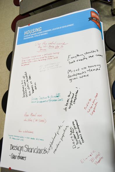
")
7 Imagine that the cost of gas hits $5 a gallon what major step would you take to soften the blow on residents' pocketbooks? (choose one)

8 Which of the following options would get residents walking and biking more often? (choose all that apply)

9 What do you believe best helps to recruit new businesses to Irondale? (choose up to 2)
10 What type of business would you like to see more in Irondale? (choose only 1)

11 Which parks within the City of Irondale do you frequent the most? (choose all that apply)


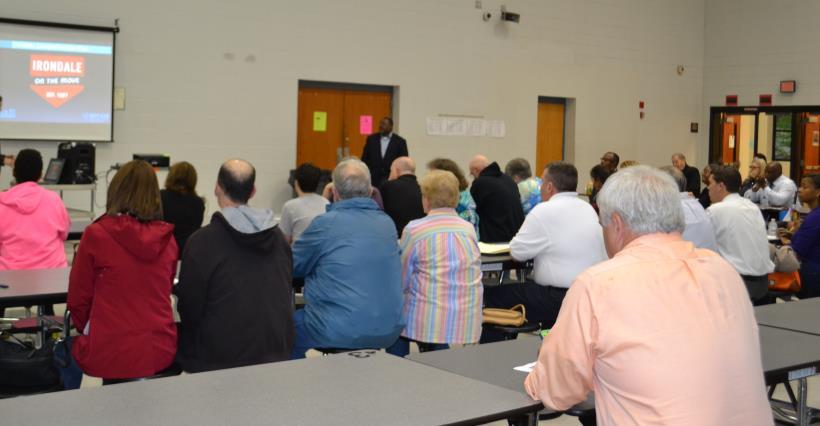
12 April 16 Open House - Summary 46 attendees

13 Council District Visioning Meetings 58 attendees

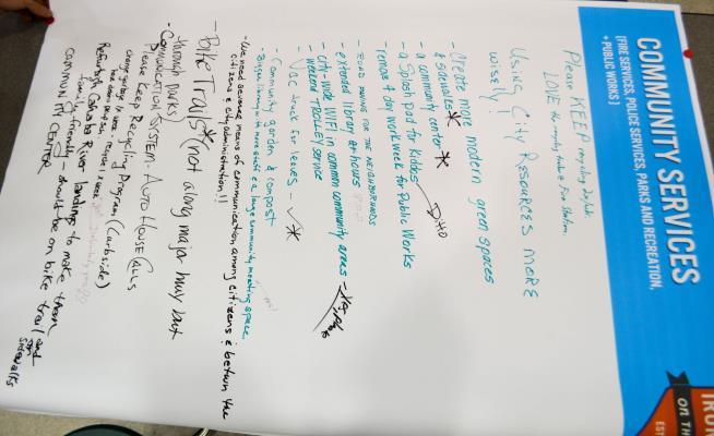
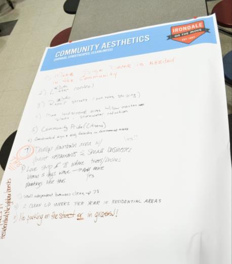
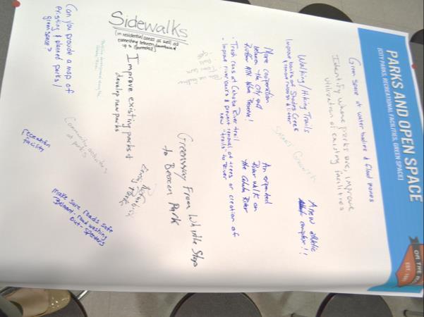
14 Issues Banners
15 Land Use and Development Issues and Desires The following is a summary of the issues that were mentioned the most: The city is in need of a grocery store. Designate space for a farmers market. Target redevelopment along US 78 / Crestwood Boulevard. Provide more dining, restaurant and entertainment options (i.e. more sit down restaurants). Redefine Irondale s commercial profile and land use. Provide more attractive commercial and retail spaces. Focus on developments that will enhance quality of life such as creating a network of urban, walkable villages to serve residential neighborhoods. Consider pop-up events, food truck rallys, and community gardening. Revitalize the downtown area with restaurants, bars / nightlife and small businesses. Capitalize on tourism and provide destination shopping to bring more tax revenue into the City such as through stores like Ikea, Costco, Super Target, Sprouts, Trader Joe's.
16 Schools and Parks Issues and Desires Schools: Intern work programs are needed. Work with businesses to provide internships and/or job shadowing opportunities for junior and senior students. Increased communication is needed for school events. Parks: Safety and maintenance are major concerns. Many people say they go to parks in neighboring municipalities because the city parks in Irondale are not clean and they do not feel safe. Although parks in neighboring municipalities might have incidents of crime and violence, residents feel difference is that those other parks are beautiful and well maintained. Residents also do not use the parks due to lack of sidewalks and public transit for access. Residents feel that there is a lack of city support for youth and athletic facilities. Provide new facilities such as a community center or athletic complex, playground equipment that is in ADA compliance, an amphitheater for music and that could be rented for weddings, movies, birthday parties, etc. Need more green spaces in residential areas.
17 Fire, Police and Library Issues and Desires Fire: Residents worry about citizen safety without a working ladder truck Police: Crime is a concern. Crime needs to be reduced so residents feel safer on foot. There is a lack of police presence in the shopping areas. Too many people are roaming around Irondale begging for money. Need to address the issue with increased loitering, including people on the streets asking for money and the bums at the interstate exit ramps. Need a communication system for automated house calls in case of emergencies. Address prostitution and other bad activity at trashy motels / hotels. Library: Expand the library or build a new library with extended hours and a business center.
18 Public Works and Revenue Dept. Issues and Desires Public Works: Resurfacing roads needs to be a priority. Neighborhoods need to be cleaned up and maintained. Code enforcement should be a priority, such as enforcing parking ordinances that discouraging the parking of vehicles in residential yards, enforcing litter control. Pick up litter. Address abandoned and blighted lots. Repave streets and repair pot holes. Signs, such as in the Holiday Gardens neighborhood are in disrepair they are leaning and faded. Need better animal control in neighborhoods; enforce the leash law. Need more sidewalks. Need a vacuum truck for leaves. Lack of attractive gateways into the city. Get better signage design throughout the city. Maintain grounds of public areas including along highways and roadways. Prevent slum lords through the strict enforcement of regulations Revenue Department: The sales tax needs to be lowered to compete with those municipalities surrounding Irondale. Mountain Brook, Hoover, Vestavia Hills and Pinson all have 3% sales tax. Need to provide better tax incentives to attract new businesses
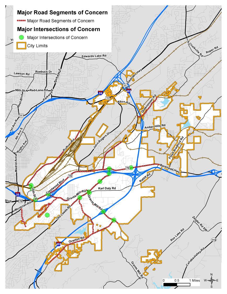
19 Transportation Concerns Through the Visioning Survey and Community Remarks tools on the project website, residents were able to express their primary transportation concerns in the City of Irondale. The following is a summary of the road segments and intersections that were mentioned the most, along with the issues of concern.
20 Major Road Segments of Concern Grants Mill Road Needs widening to four-lanes throughout (especially from Old Leeds Road to I-459). Needs a bike lane to connect with the existing segment between Old Leeds Road and Kilgore Memorial Drive. US 78 / Crestwood Boulevard The traffic light timing issues need to be fixed from city limits at the I-20 overpass to the Sam s Club entrance. Needs cross-walks, pedestrian and bicycle infrastructure. Needs repaving (fix potholes), especially at the merge area of Montclair Road at US 78 / Crestwood Boulevard. Old Leeds Road Needs bike infrastructure or widening. Needs restriping. Ruffner Road Needs major improvements since portions of the road are very dangerous. Currently the bicyclists are a hazard on the two-lane road. Designated bike lanes are needed in both directions. 16 th Street Crosswalks are needed. Alton Road Needs repaving. Kilgore Memorial Drive The right-hand turn lane onto Beacon Drive from I-20 needs to be marked as a turn lane. Scenic View Drive Needs sidewalks, bike lanes and speed bumps. Current safety concern for pedestrians. Overton Road Needs repaving, including striping and patching of potholes. Needs shoulder areas improved. Needs sidewalks. Belmont Road Speeding needs to be enforced. The drainage ditch needs to be covered. Beacon Drive / Fulmar Drive Speeding needs to be enforced or speed bumps should be added. Queenstown Road Elder Street City of Irondale should work with City of Birmingham to pick up trash on side of the road, provide sidewalk for residents to walk to commercial areas.
21 Major Intersections of Concern Grants Mill Road at Old Leeds Road Needs a right-turn lane from Grants Mill Road onto Old Leeds Road toward the schools. Need to address alignment issues, lighting, traffic light timing, handling traffic at rush hour. Grants Mill Road at I-459 Need to address intersection curve. Grants Mill Road at Overton Road Needs a traffic light. Old Leeds Road at I-20 interchange There needs to be a caution light or traffic light when turning off of I-20 to go left to toward Shades Valley High School. It is hard to turn off of US 78 or pass over the I-20 overpass with the entrance and exit ramps during rush hour. Old Leeds Road at Belmont Road Grants Mill Road at US 78 / Crestwood Boulevard Grants Mill Road at Karl Daly Road It is hard to turn left from Grants Mill Road onto Karl Daly Road. US 78 / Crestwood Boulevard at Kilgore Memorial Drive 16 th Street at 1 st Avenue North Bonnie Bell Lane at Cornell Drive 16 th Street at 2 nd Avenue North Montclair Road and US 78 / Crestwood Boulevard It is dangerous to merge onto US 78 / Crestwood Boulevard by Hamburger Heaven. US 78 at Heritage Place Drive (Jefferson Christian Academy) Needs a school zone speed limit.
22 General Transportation Concerns Signage needs to be updated (especially along US 78 / Crestwood Boulevard). Drainage ditches need to be covered on heavily used roads. Repaving and pothole repair is needed in many areas, such as 1 st avenue North, 2 nd Avenue North and the neighborhood to the north of it, 4 th Avenue North, Need for routine road and shoulder maintenance; good striping / painting for night visibility. A quiet zone (crossing where trains cannot blow their horns) is needed for the train horn noise. Lack of public transportation is a major issue (need to connect to Birmingham via the Birmingham Jefferson Transit Authority Max Bus System). Since the City of Birmingham has expressed interest in expanding metro area public transportation leading up to the World Games in 2021, then the City of Irondale should make every attempt possible to be included in this expansion. The lack of street network connectivity, transportation choices, and complementary land uses at the local level exacerbates congestion as travelers rely on a limited a number of options to travel relatively long distances for daily needs, including work, shopping, education, entertainment, medical, and recreation.
23
COWETA HIGH SCHOOL AND EAST HIGHWAY 51
 COWETA HIGH SCHOOL AND EAST HIGHWAY 51 Lack of sidewalks along Ben Lumpkin Rd. Lack of crosswalks and ramps at intersection. Hwy 51 is wide to cross as a pedestrian. No ADA compliance or connection to
What are the greatest challenges for the Route 9 Corridor? Number of responses received by category
 12 All Responses Unemployment Construction Lack of activities Lack of businesses Sanitation/Maintenance Joblessness Accidents on Route and Memorial Drive Joblessness Homeless Construction Making friends
Item to be Addressed Checklist Consideration YES NO N/A Required Description Complete Streets Guidelines
 Passaic County Complete Streets Checklist - Concept Development Project Name Item to be Addressed Checklist Consideration YES NO N/A Required Description Complete Streets Guidelines Existing Plans Have
Safe Routes to School Action Plan Aberdeen, Idaho
 Background Aberdeen, Idaho is a largely agricultural community of nearly 2,000 people and is located in the southeast portion of the state on the western edge of American Falls Reservoir. The community
4 Goals, Objectives & Actions
 Chapter4 4 This chapter presents goals, objectives, and recommended actions to support the vision of making Overland Park a safer and easier place to ride a bicycle. 35 4.1 Recommendations Structure The
NJDOT Complete Streets Checklist
 Background The New Jersey Department of Transportation s Complete Streets Policy promotes a comprehensive, integrated, connected multi-modal network by providing connections to bicycling and walking trip
5/7/2013 VIA . RE: University Village Safeway Expansion (P13-019)
") 5/7/2013 VIA EMAIL David Hung, Associate Planner Community Development Department, Current Planning Division City of Sacramento 300 Richards Boulevard, 3 rd Floor Sacramento, CA 95811 RE: University Village
5/7/2013 VIA EMAIL David Hung, Associate Planner Community Development Department, Current Planning Division City of Sacramento 300 Richards Boulevard, 3 rd Floor Sacramento, CA 95811 RE: University Village
Non-Motorized Transportation 7-1
 Non-Motorized Transportation 7-1 Transportation facilities no longer mean just accommodating a vehicle powered by a combustion engine. Pedestrian and non-motorized facilities are important modes of travel
TOWN OF WILLIAMSTON, SC BICYCLE AND PEDESTRIAN MASTER PLAN TOWN OF WILLIAMSTON, SC BICYCLE AND PEDESTRIAN MASTER PLAN
 TOWN OF WILLIAMSTON, SC BICYCLE AND PEDESTRIAN MASTER PLAN Americans Want Choices 55% of Americans would rather drive less & walk more. Transit use is growing faster than population or highway travel.
DALLAS MIDTOWN REDEVELOPMENT PLAN FOCUS NORTH TEXAS Peer Chacko, AICP, Assistant Director, City of Dallas
 DALLAS MIDTOWN REDEVELOPMENT PLAN FOCUS NORTH TEXAS 2014 Peer Chacko, AICP, Assistant Director, City of Dallas Dallas Midtown: Strategic growth area Future transit node 2 Peterson Road Study Area Galleria
2014/2015 BIKE ROUTE PLAN 83 AVENUE PROTECTED BIKE LANE
 About the Project 2014/2015 BIKE ROUTE PLAN The City of Edmonton is planning a major bike route on the south side of Edmonton. This bike route is one part of a plan to provide citizens with transportation
Proposed. City of Grand Junction Complete Streets Policy. Exhibit 10
 Proposed City of Grand Junction Complete Streets Policy Exhibit 10 1 City of Grand Junction Complete Streets Policy Vision: The Complete Streets Vision is to develop a safe, efficient, and reliable travel
7/23/2017 VIA . Michael Hanebutt City of Sacramento Community Development Department 300 Richards Boulevard, 3 rd Floor Sacramento, CA 95811
 7/23/2017 VIA EMAIL Michael Hanebutt City of Sacramento Community Development Department 300 Richards Boulevard, 3 rd Floor Sacramento, CA 95811 RE: 65 th Street Apartments (DR17-220) Dear Mr. Hanebutt:
Draft North Industrial Area-Wide Traffic Plan
 Summary of North Industrial and Hudson Bay Industrial Recommended Improvements Table 1. Summary of s Item Location 1 2 3 4 5 6 7 8 9 10 11 12 Millar Ave north of 51st St Super 8 Motel back lane 400 Block
Merrick and Memorial Neighborhood Study 5/14/2014 Public Meeting
 Merrick and Memorial Neighborhood Study 5/14/2014 Public Meeting Study Area April 9 Public Meeting Comments Summary Pedestrian Safety - A Walking Neighborhood Pedestrian traffic is very difficult A need
12/4/2016 VIA . RE: Grocery Outlet Del Paso (DR16-328)
") 12/4/2016 VIA EMAIL Ethan Meltzer, Assistant Planner City of Sacramento Community Development Department 300 Richards Blvd, 3 rd Floor Sacramento, CA 95811 RE: Grocery Outlet Del Paso (DR16-328) Dear Mr.
12/4/2016 VIA EMAIL Ethan Meltzer, Assistant Planner City of Sacramento Community Development Department 300 Richards Blvd, 3 rd Floor Sacramento, CA 95811 RE: Grocery Outlet Del Paso (DR16-328) Dear Mr.
SUMMARY OF TRANSPORTATION INVESTMENTS
 Santa Cruz County 2016 Measure D: Transportation Improvement Expenditure Plan - Approved by over 2/3 of Santa Cruz County voters on November 8, 2016 - Overview Measure D, the 2016 Transportation Improvement
Improve sidewalk/sewer drainage so it doesn't flood the streets. Improve the street lights far from each other
 More lights, cleanliness, more sidewalks Help keep city clean, water and do what the City asks to be done. Improve sidewalk/sewer drainage so it doesn't flood the streets. Improve the street lights far
Lee s Summit Road Improvement Study Public Open House June 7, 2007 Summary of Comment Card Responses
 Lee s Summit Road Improvement Study Public Open House June 7, 2007 Summary of Comment Card Responses Introduction At the Lee s Summit Road Improvement Study Public Open House held Thursday, June 7, 2007
Chapter 2. Bellingham Bicycle Master Plan Chapter 2: Policies and Actions
 Chapter 2 Bellingham Bicycle Master Plan Chapter 2: Policies and Actions Chapter 2: Policies and Actions The Bicycle Master Plan provides a road map for making bicycling in Bellingham a viable transportation
TRANSPORTATION & MOBILITY
 TRANSPORTATION & MOBILITY ROADWAY SYSTEM There are approximately 40 miles of roadways in Manitou Springs. For planning purposes, roadways are typically assigned a functional classification which defines
2018 Transportation Survey October 17, Prepared by:
 Transportation Survey October 17, Prepared by: Overview Methodology Systemwide results Strengths/Weaknesses by mode Importance of possible improvements Conclusions Methodology 500 Chittenden County residents
FY 2018 TRANSPORTATION CAPITAL PROGRAM New Jersey Department of Transportation Projects
 Camden County Bus Purchase Project ID Numbers: D0601 / 068082 In the DVRPC region, a combination of fixed route, subscription, and demand responsive transit services are provided in Camden County by Senior
Summary: Mercer County Princeton Avenue & Spruce Street Study January 2009
 Summary: Several recent studies have assessed potential development and redevelopment opportunities in the Mercer Crossing area of Trenton, Ewing, and Lawrence. This Princeton Avenue and Spruce Street
FUNDING OPTIONS FOR COMPLETE STREETS PROJECTS. Dean Ledbetter, PE Senior Planning Engineer NCDOT Division Eleven
 FUNDING OPTIONS FOR COMPLETE STREETS PROJECTS Dean Ledbetter, PE Senior Planning Engineer NCDOT Division Eleven DIVISION ELEVEN PRESENTATION OVERVIEW Sample Complete Streets Projects in Division Eleven
Bicycle-Pedestrian Master Plan: Chapters 3 and 4 Distribution
 Bicycle-Pedestrian Master Plan: Chapters 3 and 4 Distribution Finksburg Planning and Citizens Council March 22, 2018 Overview Progress Citizen Outreach Vision Chapter 3 - Existing Conditions Chapter 4
Agenda. Overview PRINCE GEORGE S PLAZA METRO AREA PEDESTRIAN PLAN
 PRINCE GEORGE S PLAZA METRO AREA PEDESTRIAN PLAN May 28, 2008 Agenda Welcome and introductions Project overview and issue identification Planning context and strengths Design challenges and initial recommendations
ROUTE 81 CORRIDOR STUDY DESIGN CONCEPTS
 RT 81 Corridor Study CLINTON ROUTE 81 CORRIDOR STUDY DESIGN CONCEPTS View north on High Street, with potential improvements to the streetscape Draft Recommendations November 8 th, 2018 TOWN OF CLINTON
Solana Beach Comprehensive Active Transportation Strategy (CATS)
") Solana Beach Comprehensive Active Transportation Strategy (CATS) 3.0 Goals & Policies The Solana Beach CATS goals and objectives outlined below were largely drawn from the Solana Beach Circulation Element
Solana Beach Comprehensive Active Transportation Strategy (CATS) 3.0 Goals & Policies The Solana Beach CATS goals and objectives outlined below were largely drawn from the Solana Beach Circulation Element
What are the Qualities that make Newark a Bicycle Friendly Community? What are aspects that make Newark less Bicycle Friendly?
 What are the Qualities that make Newark a Bicycle Friendly Community? Many stores are within biking distance (1) Lots of bike lanes and new trail Existing bike routes (2) Designated bike lanes on Del ave.
MAG Town of Cave Creek Bike Study Task 6 Executive Summary and Regional Significance Report
 Page 1 MAG Town of Cave Creek Bike Study Task 6 Executive Summary and Regional Significance Report August 1, 2012 MAG Project #481 Page 2 Task 6 Executive Summary and Regional Significance Report Introduction
RESOLUTION NO ?? A RESOLUTION OF THE CITY OF NEPTUNE BEACH ADOPTING A COMPLETE STREETS POLICY
 RESOLUTION NO. 2018-?? A RESOLUTION OF THE CITY OF NEPTUNE BEACH ADOPTING A COMPLETE STREETS POLICY WHEREAS, safe, convenient, and accessible transportation for all users is a priority of the City of Neptune
Prince George s County plans, policies, and projects
 Prince George s County plans, policies, and projects Over 250 projects for trails, bikeways, designated bike lanes and sidewalk construction Trail projects that improve access to Metro Sidewalk and trail
PRINCE GEORGE S PLAZA METRO AREA PEDESTRIAN PLAN
 PRINCE GEORGE S PLAZA METRO AREA PEDESTRIAN PLAN May 28, 2008 Agenda Welcome and introductions Project overview and issue identification Planning context and strengths Design challenges and initial recommendations
Strategies to Promote the Availability of Affordable Healthy Food and Beverages
 Strategies to Promote the Availability of Affordable Healthy Food and Beverages CDC Recommended Strategies and Measurements Strategy #1: Communities Should Increase Availability of Healthier Food and Beverage
Morristown, NJ Complete Streets Policy
 Morristown, NJ Complete Streets Policy Introduction A Complete Street is defined as a means to provide safe access for all users by designing and operating a comprehensive, integrated, connected multi-modal
Plan Peoria AZ Public Workshop #1 April Day # Green, Red, or Yellow Category: (Public Safety, Transportation, Parks and Recreation, Natural Envi
 Plan Peoria AZ Public Workshop #1 April 24-26 Day # Green, Red, or Yellow Category: (Public Safety, Transportation, Parks and Recreation, Natural Environment, Land Use, Economic Development) Mapping Exercise
Y O R K R O A D. Baltimore, Maryland. ULI Technical Assistance Panel June 18 & 19, York Road Technical Assistance Panel
 Y O R K R O A D Baltimore, Maryland ULI Technical Assistance Panel June 18 & 19, 2013 The York Road TAP Team ULI York Road TAP Chairperson Addison Palmer, STV Incorporated Technical Assistance Panelists
CONNECTING PEOPLE TO PLACES
 CONNECTING PEOPLE TO PLACES 82 EAST BENCH MASTER PLAN 07 Introduction The East Bench transportation system is a collection of slow moving, treelined residential streets and major arteries that are the
Speed Limits Study and Proposal. Public Input Session: 8/14/13
 Speed Limits Study and Proposal Public Input Session: 8/14/13 Why is Decatur a unique place for this project? First Community Transportation Plan in the nation with a Health Impact Assessment. Strong sense
Table #6 VISION CHARACTERISTICS
 Table #6 VISION White Flint is a place to live, work, play, shop, and walk with sufficient density to encourage quality redevelopment. Vibrant streets and consistent streetscapes are important. CHARACTERISTICS
SAFE ROUTES TO SCHOOL
 SAFE ROUTES TO SCHOOL Edgewood Elementary School Existing Conditions and ACTION PLAN > Oak Creek - Franklin Joint School District Table of Contents CONTEXT Enrollment Boundaries Enrollment
Bikeway action plan. Bicycle Friendly Community Workshop March 5, 2007 Rochester, MN
 Bikeway action plan Summary The was held on March 5, 2007 at the Rochester Mayo Civic Center. The workshop was hosted by Rochester-Olmsted County Planning Department in collaboration with the League of
6/22/2018 VIA . Darcy Goulart, Planning Manager City of Rancho Cordova Planning Department 2729 Prospect Park Drive Rancho Cordova, CA 95670
 6/22/2018 VIA EMAIL Darcy Goulart, Planning Manager City of Rancho Cordova Planning Department 2729 Prospect Park Drive Rancho Cordova, CA 95670 RE: Quick Quack Car Wash (DD9801) Dear Ms. Goulart: WALKSacramento
Fill in the rating for each section. Total up the ratings to see how your neighbourhood scores overall for walkability.
 WALKABILITY CHECKLIST How walkable is your community? Everyone benefits from walking and other forms of active transportation. These benefits include: improved fitness, cleaner air, reduced risks of certain
Austin Avenue Bridges Project. Public Meeting Summary
 Austin Avenue Bridges Project Public Meeting Summary June 29, 2016 Red Table Safety and Connectivity Notes: 1. Would like to see forensic report evaluations 2. What is the lifespan? 3. Extend safety considerations
Introduction. North 12 th Complete Street Project Overview
 Introduction On Wednesday, March 1, 2017, the City of Sacramento, in partnership with Sacramento Regional Transit District and the Sacramento Housing and Redevelopment Agency, hosted a community outreach
Project Launch Community Meeting 1 Summary
 ConsumersNext: Planning for People and Business at Sheppard and Victoria Park Project Launch Community Meeting 1 Summary Participants Listening to the Overview Presentation Prepared for the City of Toronto
Chapter 5 Future Transportation
 Chapter 5 Future Transportation The Future Land Use Plan identifies the desired land use designations. The land uses desired for Crozet depend, in large part, on the success of the transportation system,
Route 29 Solutions Projects
 Route 29 Solutions Route 29 Solutions Projects www.route29solutions.org October 10, 2014 Route 29 Widening to Six Lanes Albemarle County This project will widen a 1.8-mile segment of Route 29 from four
10/8/2014 VIA . RE: CVS Pharmacy (P13-002) Revised August 2014
 Revised August 2014") 10/8/2014 VIA EMAIL David Hung, Associate Planner Community Development Department, Current Planning Division City of Sacramento 300 Richards Boulevard, 3 rd Floor Sacramento, CA 95811 RE: CVS Pharmacy
10/8/2014 VIA EMAIL David Hung, Associate Planner Community Development Department, Current Planning Division City of Sacramento 300 Richards Boulevard, 3 rd Floor Sacramento, CA 95811 RE: CVS Pharmacy
2760 Cameron Road, West Kelowna, BC V1Z 2T6 Tel.: ; Fax:
 Hello West Kelowna Resident! You have been randomly selected to participate in the City of West Kelowna s Annual Citizens Survey. This anonymous, statistically-accurate survey provides West Kelowna Council
Coachman Ridge Neighborhood Plan. Neighborhood Strengths and Weaknesses
 Coachman Ridge Neighborhood Plan Neighborhood Strengths and Weaknesses At the first public neighborhood meeting held by the study committee on March 22, 2001, participants divided up into three groups
WALKABILITY CHECKLIST How walkable is your community?
 WALKABILITY CHECKLIST How walkable is your community? Everyone benefits from walking and other forms of active transportation. These benefits include: improved fitness, cleaner air, reduced risks of certain
May 12, 2016 Metro Potential Ballot Measure Issue Brief: Local Return
 Summary: Local return is an important revenue source for cities to maintain their local transportation infrastructure. Most cities use their local return to operate small bus systems and repave streets,
Perryville Transit Oriented Development & Greenway Plan
 A Partnership of the Town of Perryville and WILMAPCO Perryville Transit Oriented Development & Greenway Plan Why plan for TOD and Greenways? Identify strategies to enhance community character in Perryville
TRAFFIC ACTION PLAN. North Central Neighborhood CITY OF SAN MATEO
 TRAFFIC ACTION PLAN North Central Neighborhood CITY OF SAN MATEO Draft February 2017 Table of Contents Introduction... 1 The Traffic Forum Process... 4 Neighborhood Traffic Issues... 6 Neighborhood Recommendations
2018 Pedestrian and Bicycle and Safe Routes to School Application for Funding Page 1 of 31
 2018 Pedestrian and Bicycle and Safe Routes to School Application for Funding Page 1 of 31 2018 Pedestrian and Bicycle and Safe Routes to School Application for Funding Part 1: General Information Funding
MASTER BICYCLE AND PEDESTRIAN PLAN
 VILLAGE OF NORTHBROOK MASTER BICYCLE AND PEDESTRIAN PLAN DRAFT PLAN OPEN HOUSE May 2, 2018 AGENDA 1. Community Engagement 2. Vision and Goals 3. General Structure of Plan 4. Recommendations Overview 5.
Houma-Thibodaux Metropolitan Planning Organization STP<200K Funding Application APPLICATION
 APPLICATION HOUMA-THIBODAUX METROPOLITAN PLANNING ORGANIZATION (HTMPO) FOR SURFACE TRANSPORTATION PROGRAM (STP
City of Birmingham Draft Multi-modal Transportation Plan
 City of Birmingham Draft Multi-modal Transportation Plan City Commission Public Hearing Monday, November 25, 2013 7:30 pm Norman Cox, PLA, ASLA The Greenway Collaborative, Inc. Ann Arbor, Michigan The
10/30/2012 VIA
 10/30/2012 VIA EMAIL David Hung, Associate Planner Community Development Department, Current Planning Division City of Sacramento 300 Richards Blvd., 3 rd Floor Sacramento, CA 95811 RE: The Cannery On-Site
City of Davis East Covell Corridor Plan
 Community Open House #2 January 22, 2014 6:00 8:00 p.m. Veterans Memorial Center, Club Room City of Davis Introduction The (ECCP) is a taking a comprehensive look at the existing transportation systems
New Brunswick Strategic Planning Proposal
 New Brunswick Strategic Planning Proposal Proposal Title: Rutgers University Crosswalk Enhancement Project Proposal Initiator: Rutgers University Division of Administration and Public Safety Executive
PRIORITIES RESULTS YOUR PRIORITIES FOR BRIDGEPORT 5% 4% 13% RESIDENTIAL CHOICES TRAILS & PARKS
 Community Visioning Open House The Community Visioning Open House was held on January, 31st 2018 at Harrisburg Area Community College (HACC), Lancaster Campus. Approximately 80 people attended this Open
El Paso County 2040 Major Transportation Corridors Plan
 El Paso County 2040 Major Transportation Corridors Plan Connect-our-County Online Transportation User Survey Preliminary Results June 24, 2010 Years of Residence 2. How many years have you LIVED HERE?
11/3/2014 VIA . WALKSacramento has reviewed the Stockton and T Mixed-Use project at 3675 T Street in the
 11/3/2014 VIA EMAIL Antonio Ablog Planning Department City of Sacramento 300 Richards Boulevard Sacramento, CA 95811 RE: Design Review for Stockton and T Mixed-Use (P14-042) Dear Mr. Ablog: WALKSacramento
San Francisco Asian, Inc.
 San Francisco Asian, Inc. Plan Bay Area Community-Based Outreach Outreach area: South of Market/Tenderloin in San Francisco, California Outreach description: Outreach in April and May 2011 through door
TRANSPORTATION TRAINING TOPICS. April 6, 2010
 TRANSPORTATION TRAINING TOPICS April 6, 2010 Roles of Transportation Providers Context and Policy Makers Division of Transportation and Traffic Other City Operations Other Transportation Operators CMA
WALK- AND bike-friendly TURLOCK
 WALK- AND bike-friendly TURLOCK Ideas to Encourage Walking and Biking Benefits to the COMMUNITY Get Connected People who walk and bike have many more opportunities for casual interactions with friends
Do you support funding a Vision Zero approach for pedestrian & cycling safety citywide?
 Councilman Kenyatta Johnson Second Council District The 5th Square PAC CANDIDATE QUESTIONNAIRE VISION ZERO Do you support funding a Vision Zero approach for pedestrian & cycling safety citywide? Would
Tonight is for you. Learn everything you can. Share all your ideas.
 Strathcona Neighbourhood Renewal Draft Concept Design Tonight is for you. Learn everything you can. Share all your ideas. What is Neighbourhood Renewal? Creating a design with you for your neighbourhood.
4/14/2017 VIA . Miriam Lim, Junior Planner City of Sacramento Community Development Department 300 Richards, 3 rd Floor Sacramento, CA 95811
 4/14/2017 VIA EMAIL Miriam Lim, Junior Planner City of Sacramento Community Development Department 300 Richards, 3 rd Floor Sacramento, CA 95811 RE: Mack & Franklin Development (P17-016) Dear Ms. Lim:
Centennial Neighbourhoods Transportation Management Plan Summary of Phase 1 Consultation. Overview of Issues
 1 Centennial Neighbourhoods Transportation Management Plan Summary of Phase 1 Consultation The Centennial Neighbourhoods Transportation Management Plan (CNTMP) is being undertaken to support the Secondary
Goodlettsville Bicycle and Pedestrian Plan Executive Summary
 Goodlettsville Bicycle and Pedestrian Plan July 2010 In Cooperation with the Nashville Area Metropolitan Planning Executive Organization Summary Introduction Progressive and forward thinking communities
Route 7 Corridor Study
 Route 7 Corridor Study Executive Summary Study Area The following report analyzes a segment of the Virginia State Route 7 corridor. The corridor study area, spanning over 5 miles in length, is a multi
Rock Spring Kick-Off Meeting 09/01/15 Walter Johnson High School Break Out Table Summaries. Rock Spring Break Out Table Comments. Table 1: Strengths:
 Rock Spring Break Out Table Comments Table 1: Strengths: Trees, open areas 1 Medical Care, Offices Parking at Medical important Mall access Good access to emergency services/police/ambulance/fire Weaknesses:
Executive Summary Route 30 Corridor Master Plan
 Route Corridor Master Plan Project Overview The Route Corridor Master Plan is a coordinated multimodal transportation and land use plan for the entire stretch of Route through East Whiteland Township,
MERRIMACK TOWN CENTER PEDESTRIAN AND TRAIL MASTER PLAN
 MERRIMACK TOWN CENTER PEDESTRIAN AND TRAIL MASTER PLAN NOVEMBER 12, 2009 PREPARED BY: NASHUA REGIONAL PLANNING COMMISSION Cover art designed at www.wordle.net/create. This design is based upon the words
PEDESTRIAN ACTION PLAN
 ATTACHMENT 2 CITY OF SANTA MONICA PEDESTRIAN ACTION PLAN CITY OF SANTA MONICA PEDESTRIAN ACTION PLAN This page intentionally left blank EXECUTIVE SUMMARY CHAPTER 1 EXECUTIVE SUMMARY Setting the Stage
o n - m o t o r i z e d transportation is an overlooked element that can greatly enhance the overall quality of life for the community s residents.
 N o n - m o t o r i z e d transportation is an overlooked element that can greatly enhance the overall quality of life for the community s residents. 84 Transportation CHAPTER 11 INTRODUCTION Transportation
9/21/2016 VIA . RE: The Knot (DR16-270)
") 9/21/2016 VIA EMAIL Garrett Norman, Assistant Planner City of Sacramento Community Development Department 300 Richards Boulevard, 3 rd Floor Sacramento, CA 95811 RE: The Knot (DR16-270) Dear Mr. Norman:
9/21/2016 VIA EMAIL Garrett Norman, Assistant Planner City of Sacramento Community Development Department 300 Richards Boulevard, 3 rd Floor Sacramento, CA 95811 RE: The Knot (DR16-270) Dear Mr. Norman:
PRESS RELEASE San Joaquin Council of Governments
 PRESS RELEASE San Joaquin Council of Governments For Immediate Release February 23, 2018 Contact: Nicole Gorham, 235-0582 gorham@sjcog.org SJCOG Board Awards $19.63 Million in Measure K Bicycle, Pedestrian,
Bicycle and Pedestrian Plans and Improvements
 Bicycle and Pedestrian Plans and Improvements Presented to the City Council By Randle Harwood, Planning and Development, and Richard Zavala, Parks and Community Services September 24, 2013 Purpose Review
Bluffdale/ UDOT South High-T Intersection Project Type Operations
 Bluffdale/ UDOT 14600 South High-T Intersection Project Type Operations 14600 South and Redwood Road $ 600,000 $ 550,000 This project is to install a new High-T intersection at Redwood Road and 14600 South
JEFFERSON COUNTY BIKE PLAN 2010: EMPHASIS SUMMARY
 JEFFERSON COUNTY BIKE PLAN 2010: EMPHASIS SUMMARY Presented at Jefferson and Walworth County Bicycle Forum Series Summer 2011 By: Steve Grabow, Professor and Community Development Educator UW-Extension,
CANDIDATE QUESTIONNAIRE
 CANDIDATE QUESTIONNAIRE INTRODUCTION Name: Anthony H. Williams Seeking The Office Of: Mayor Political Party Affiliation: Democrat Campaign Website and/or Facebook page: www.anthonyhwilliams.com https://www.facebook.com/jointeamtony
East Burke Transportation, Safety and Capacity Improvements
 East Burke Transportation, Safety and Capacity Improvements The purpose of this project is to increase mobility and improve safety for pedestrians, cyclists, and motor vehicles along VT Route 114 in the
General Plan Community Meeting Summary Ward 3 Santiago Elementary School 2212 North Baker Street Thursday, March 31, :00 p.m. to 8:00 p.m.
 PARTICIPANTS General Plan Community Meeting Summary Ward 3 Santiago Elementary School 2212 North Baker Street Thursday, March 31, 2016 6:00 p.m. to 8:00 p.m. A General Plan community meeting was held on
Section 2: Importance-Satisfaction Analysis
 Section 2: Importance- Analysis ETC Institute (2009) 35 Overview Importance- Analysis Blue Springs, MO Today, city officials have limited resources which need to be targeted to activities that are of the
ACTIVE TRANSPORTATION
 ACTIVE TRANSPORTATION Mobility 2040 Supported Goals Improve the availability of transportation options for people and goods. Support travel efficiency measures and system enhancements targeted at congestion
Riverside Drive Complete Streets Project 3 rd Community Meeting. March 26, 2015
 Riverside Drive Complete Streets Project 3 rd Community Meeting March 26, 2015 Providing Feedback Sign-In with contact information for future updates Complete questionnaire provided tonight Complete comment
CITY OF COCOA BEACH 2025 COMPREHENSIVE PLAN. Section VIII Mobility Element Goals, Objectives, and Policies
 CITY OF COCOA BEACH 2025 COMPREHENSIVE PLAN Section VIII Mobility Element Goals, Objectives, and Policies Adopted August 6, 2015 by Ordinance No. 1591 VIII MOBILITY ELEMENT Table of Contents Page Number
EXECUTIVE SUMMARY. Vision
 Vision Walking and bicycling in Salt Lake City will be safe, convenient, comfortable, and viable transportation options that connect people to places, foster recreational and economic development opportunities,
2014/2015 BIKE ROUTE PLAN 83 AVENUE PROTECTED BIKE LANE
 About the Project The City of Edmonton is planning a major bike route on the southside of Edmonton. The Strathcona Bike Route will connect the communities of Strathcona, Garneau and the University area,
Cherry Creek Transportation and Land Use Forum September 25, 2013 Meeting Summary
 Cherry Creek Transportation and Land Use Forum September 25, 2013 Meeting Summary I. LEAD-IN TO SMALL GROUP DISCUSSION, POLLING AND STEERING COMMITTEE/TECHNICAL TASK FORCE DISCUSSION The meeting began
Description: Improve I-71 corridor from I-64 to I-265. Approximately 9.1 miles.
 I-71 KIPDA ID # 130 Project Type: ROADWAY CAPACITY Description: Improve I-71 corridor from I-64 to I-265. Approximately 9.1 miles. Purpose: Improve capacity and level of service along I-71 in the project
WILMAPCO Public Opinion Survey Summary of Results
 Wilmington Area Planning Council WILMAPCO Public Opinion Survey Summary of Results Prepared by: 2955 Valmont Road, Suite 300 Boulder, Colorado 80301 t: 303-444-7863 f: 303-444-1145 www.n-r-c.com Table
State Road 54/56 Tampa Bay s Northern Loop. The Managed Lane Solution Linking I-75 to the Suncoast Parkway
 State Road 54/56 Tampa Bay s Northern Loop The Managed Lane Solution Linking I-75 to the Suncoast Parkway SUNCOAST PARKWAY Both I 75 and the Suncoast Parkway are planning, or in the process of constructing,
Neighborhood Walking, Biking, and Transit Tours Summary BACKGROUND
 Neighborhood Walking, Biking, and Transit Tours Summary BACKGROUND Six tours were scheduled during the week of May 11, 2015. The intent of the tours was for City Staff to experience the corridor with locals