Route 79/Davol Street Corridor Study
|
|
|
- Zoe Gregory
- 5 years ago
- Views:
Transcription


1 Route 79/Davol Street Corridor Study Fall River, MA Public Information Meeting #2 November 21, 2013 Fall River Heritage State Park Fall River, MA
2 Agenda Welcome and Introductions Overview of Study Process Review of Study Goals and Objectives Summary of Existing and Future No-Build Conditions Review of Issues, Constraints and Opportunities Alternatives Development Alternatives Analysis
3 Welcome and Introductions MassDOT - Ethan Britland Project Manager Study Team Joe Cahill Consultant Team Project Manager (TranSystems) Lenny Velichansky Consultant Deputy Project Manager/Traffic (TranSystems) Teresa Sandell Traffic and Roadway Design (TranSystems) Jill Barrett Public Involvement (Fitzgerald & Halliday) Margaret Collins Land Use/Economic Development (Cambridge Economics) Sudhir Murthy Traffic (TrafInfo) Deanna Peabody Traffic (TrafInfo)


4 Study Process Task 1 Develop Goals & Objectives, Evaluation Criteria and Public Involvement Plan Task 2 Task 3 Identify Existing and Future No-Build Conditions and Evaluate Issues Develop Transportation Alternatives Task 4 Task 5 Analyze Alternatives Develop Final Recommendations
5 Task 1 Task 1 Goals and Objectives Study Area Evaluation Criteria Public Involvement Process
6 Goals and Objectives
7 Goals and Objectives Objectives Provide better multimodal connectivity between Fall River neighborhoods and its waterfront Enhance multimodal access to the future South Coast Rail Balance local and regional mobility Improve and enhance safety conditions Increase opportunities for economic development and land use Minimize potential impacts to the environment and community

8 Focus Area

9 Regional Transportation Impact Area Braga Bridge Wilbur Avenue I-195/Route 79 Interchange Design-Build Project N. Main Street Highland Avenue Veterans Memorial Bridge Taunton River Route 79 / Davol Street Corridor Eastern Avenue Watuppa Pond
10 Evaluation Criteria Evaluation Criteria Categories Mobility Safety Health and Environmental Effects Land Use and Economic Development Community Effects Cost

11 Public Involvement Plan Working Group Meetings Local officials & community members 7 meetings Provides input to the team on the study process Represents respective organizations with two-way communication Public Meetings 2 meetings Newsletters Study Website:
12 Task 2 Task 2 Existing Conditions Future No-Build Conditions Issues, Constraints and Opportunities


13 2035 Developments (No-Build Scenario) Restaurant on Remington Ave. 125 New Jobs Regata Club 70 New Jobs Marina at City Pier 6 New Jobs Commonwealth Landing Mill Population New Jobs South Coast Rail Focus Area Total Population New Jobs
14 Existing and Future No-Build Conditions Traffic

15 Level of Service Criteria
16 2012 Existing Traffic Operation Regional Level Legend AM PM Braga Bridge Wilbur Ave Veterans Memorial Bridge Taunton River President Avenue Eastern Avenue Watuppa Pond
17 2035 No-Build Traffic Operation Regional Level Legend AM PM Braga Bridge Wilbur Ave Veterans Memorial Bridge Taunton River President Avenue Eastern Avenue Watuppa Pond
18 2012 Existing Traffic Operation Focus Area Level Legend AM PM
19 2035 No-Build Traffic Operation Focus Area Level Legend AM PM
20 Existing and Future No-Build Conditions Safety
21 Three-Year Crash History ( ) 10 Crashes Rate = Crashes Rate = Crashes Rate = Crashes Rate = Crashes Rate = Crashes Rate = Crashes Rate = Crashes Rate = Crashes Rate = Crashes Rate = 2.00
22 Existing and Future No-Build Conditions Pedestrian and Bicycle Access
23 Pedestrian and Bicycle Circulation Routes

24 Pedestrian and Bicycle Circulation Routes

25 Pedestrian and Bicycle Circulation Routes

26 Pedestrian and Bicycle Circulation Routes
27 Pedestrian and Bicycle Circulation Routes

28 Pedestrian and Bicycle Circulation Routes

29 Quequechan River Bike Trail and Regional Connections Existing Path Planned Path Future Connector Braga Bridge Wilbur Avenue Proposed Quequechan River Bike Trail N. Main Street Future Connector President Avenue Veterans Memorial Bridge Taunton River Existing Quequechan River Bike Trail Watuppa Pond
30 Existing and Future No-Build Conditions Transit


31 Future Transit South Coast Rail
32 Existing and Future No-Build Conditions Issues, Constraints and Opportunities
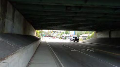
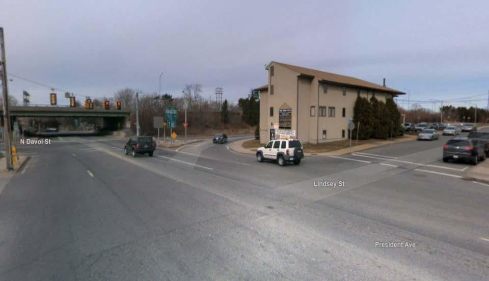
33 Issues & Constraints - Transportation High crash rates on President Avenue and Davol Street A number of crashes involving pedestrians Lack of continuity in pedestrian paths of travel Lack of designated provisions for bicycles Limited connectivity between areas east and west of Rte. 79
34 Opportunities - Transportation Excess capacity on Route 79 allows some flexibility in development of alternatives Reconfiguration of Route 79/Davol Street Corridor will facilitate safety and circulation improvements for all modes
35 Issues & Constraints Economic Development and Land Use Economic: Low income/high unemployment/poverty Low Real Estate prices indicate weak demand Land Use: Underutilized sites on the west side of Davol Street Shallow sites on east side of Davol St. Rail barrier on east side of study area from Central to Pearce Street
36 Opportunities Economic Development and Land Use South Coast Rail Transit Oriented Development potential Good supply of redevelopment sites along the river Riverfront becoming a regional draw
37 Task 3 Task 3 Transportation Alternatives Development
38 Transportation Alternatives Development Short-Term Improvements Mid-Term Improvements Long-Term Alternatives
39 Transportation Alternatives Development Short-Term and Mid-Term Improvements
40 Short-Term Safety Improvements 45 Crashes Rate = 2.00

41 Short-Term Safety Improvements
42 Short-Term Safety Improvements

43 Short-Term Safety Improvements

44 Short-Term Safety Improvements 48 Crashes Rate = Crashes Rate = 0.84
45 Short-Term Safety Improvements

46 Short-Term Safety Improvements

47 Short-Term Bicycle Circulation Improvements

48 Short-Term Bicycle Circulation Improvements

49 Short-Term Bicycle Circulation Improvements


50 Short-Term Bicycle Circulation Improvements

51 Short-Term Bicycle Circulation Improvements
52 Short-Term Bicycle Circulation Improvements

53 Short-Term Bicycle Circulation Improvements

54 Short-Term Bicycle Circulation Improvements

55 Short-Term Bicycle Circulation Improvements
56 Short-Term Bicycle Circulation Improvements

57 Mid-Term Bicycle Circulation Improvements

58 Transportation Alternatives Development Long-Term Alternatives
59 Long-Term Alternatives Alternative 1: Elevated Limited Access Route 79 Alternative 2: Urban Boulevard Alternative 3: Boulevard with Frontage Roads
60 Alternative 1: Elevated Limited Access Rte. 79
61 Alternative 1: Elevated Limited Access Rte. 79

62 Alternative 1: Elevated Limited Access Rte. 79

63 Alternative 1: Elevated Limited Access Rte. 79

64 Alternative 1: Elevated Limited Access Rte. 79

65 Alternative 1: Elevated Limited Access Rte. 79
66 Alternative 2: Urban Boulevard
67 Alternative 2: Urban Boulevard

68 Alternative 2: Urban Boulevard

69 Alternative 2: Urban Boulevard

70 Alternative 2: Urban Boulevard
71 Alternative 2: Urban Boulevard

72 Alternative 3: Boulevard with Frontage Roads

73 Alternative 3: Boulevard with Frontage Roads

74 Alternative 3: Boulevard with Frontage Roads
75 Alternative 3: Boulevard with Frontage Roads

76 Alternative 3: Boulevard with Frontage Roads

77 Alternative 3: Boulevard with Frontage Roads
78 Task 4 Task 4 Alternatives Analysis
79 Assumed Development Mix Based on Commonwealth Landing Mill Consistent with 2002 Harbor Plan 5-Story Buildings Retail: One Floor Office: One Floor Residential: 3 Floors
80 Maximum Development Potential Maximum Physical Build-Out Land Use Alternative 1 Elevated Route 79 Alternative 2 Urban Boulevard Alternative 3 Boulevard with Frontage Roads Parcel Size 10.1 ac Parcel Size: 10.6 ac Parcel Size: 15.0 ac Retail 265,912 sf 280,041 sf 398,209 sf Residential 797,737 sf 840,122 sf 1,194,626 sf Office 265,912 sf 280,041 sf 398,209 sf Total Developable Area 1,329,561 sf 1,400,204 sf 1,991,044 sf
81 Supported Development Potential Maximum Build-Out Supported by Proposed Roadway Infrastructure Alternative Component Alternative 1 Elevated Rte. 79 Alternative 2 Urban Boulevard Alternative 3 Frontage Roads Development Area 1.3m sf (100% of max) 1.2m sf (85% of max) 0.3m sf (15% of max) Parking Requirements* 960 spaces 877 spaces 296 spaces Open Space within Parcels 2.45 ac (24%) 3.73 ac (35%) ac (89%) Construction Cost $100m $55m $55m * Assumes structured parking
82 Alternative 1 - Traffic Operation: Regional Level Braga Bridge Wilbur Ave Veterans Memorial Bridge Taunton River Highland Avenue President Avenue Eastern Avenue Watuppa Pond

83 Alternative 1 - Traffic Operation: Focus Area Level Legend AM PM
84 Alternative 2 PM Peak Hour Traffic Diversions Westbound diversion 200 vehicles per hour Braga Bridge Wilbur Ave Eastbound diversion 300 vehicles per hour Veterans Memorial Bridge Taunton River Highland Avenue President Avenue Eastern Avenue Watuppa Pond
85 Alternative 2 - Traffic Operation: Regional Level Braga Bridge Wilbur Ave Veterans Memorial Bridge Taunton River Highland Avenue President Avenue Eastern Avenue Watuppa Pond
86 Alternative 2 - Traffic Operation: Focus Area Level Legend AM PM
87 Alternative 3 PM Peak Hour Traffic Diversions Westbound diversion 100 vehicles per hour Braga Bridge Wilbur Ave Eastbound diversion 200 vehicles per hour Veterans Memorial Bridge Taunton River Highland Avenue President Avenue Eastern Avenue Watuppa Pond
88 Alternative 3 - Traffic Operation: Regional Level Braga Bridge Wilbur Ave Veterans Memorial Bridge Taunton River Highland Avenue President Avenue Eastern Avenue Watuppa Pond
89 Alternative 3 Traffic Operation: Focus Area Level Legend AM PM

90 Alternative 1: Elevated Limited Access Rte. 79

91 Alternative 1: Elevated Limited Access Rte. 79

92 Alternative 2: Urban Boulevard

93 Alternative 2: Urban Boulevard

94 Alternative 3: Boulevard with Frontage Roads

95 Alternative 3: Boulevard with Frontage Roads
96 Evaluation Matrix Mobility Alternatives MOBILITY No Build 1 Elevated Route 79 with Cross Connections 2 At Grade Route 79 Boulevard 3 At Grade Route 79 with Frontage Roads Rating Discussion Rating Discussion Rating Discussion Rating Discussion Diversions No Diversions No Diversions 500 Vehicles Diverted 300 Vehicles Diverted Number of Traffic Signals 2 Traffic Signals On Davol Street 7 Traffic Signals On Davol Street 4 Traffic Signals On Route 79 6 Traffic Signals On Route 79 and Davol Street Operation 1 Intersection Operates at Level of Service D 1 Intersection Operates at Level of Service F 1 Intersection Operates at Level of Service D All Intersections Operate at Level of Service C or better 2 Intersections Operate at Level of Service D 1 Intersection Operates at Level of Service E Legend Some Moderate Substantial Benefits Impacts Neutral
97 Evaluation Matrix Mobility Alternatives MOBILITY Travel Time Route 79 * (minutes) Travel Time Davol Street * (minutes) Pedestrian Delay (along President Ave from Lindsey St to Bicentennial Park) Pedestrian Time Savings (Turner St to City Pier) (Existing travel time is 17 min 34 sec) No Build 1 Elevated Route 79 with Cross Connections 2 At Grade Route 79 Boulevard 3 At Grade Route 79 with Frontage Roads Rating Discussion Rating Discussion Rating Discussion Rating Discussion AM PM AM PM AM PM AM PM Northbound Northbound Northbound Northbound Southbound Southbound Southbound Southbound AM PM AM PM AM PM AM PM Northbound Northbound Northbound Northbound Southbound Distance: 450 feet PM Peak Hour: 1 min 24 sec Distance: 3,400 feet 0 min 0 sec Southbound Distance: 450 feet PM Peak Hour: 1 min 24 sec Distance: 560 feet PM Peak Hour: 13 min 30 sec Southbound Distance: 450 feet PM Peak Hour: 1 min 46 sec Distance: 560 feet PM Peak Hour: 13 min 8 sec Southbound Distance: 450 feet PM Peak Hour: 2 min 55 sec Distance: 560 feet PM Peak Hour: 11 min 59 sec * Travel Time along Route 79 and Davol Street is measured between Cedar Street and the Route 6 Overpass (approximately 1 mile) Legend Benefits Impacts Neutral Some Moderate Substantial
98 Evaluation Matrix Safety Considerations Alternatives SAFETY Pedestrian and Bicycle Safety No Build 1 Elevated Route 79 with Cross Connections 2 At Grade Route 79 Boulevard 3 At Grade Route 79 with Frontage Roads Rating Discussion Rating Discussion Rating Discussion Rating Discussion Existing wheelchair ramps and sidewalks do not meet current design standards and ADA requirements No designated bicycle facilities are provided within the corridor Sidewalks provided along one side of NB and SB Davol Streets ADA compliant crossings at all intersections and driveways. Designated sidewalks and bike facilities provided throughout project limits. East-west access provided for bicycles and pedestrians along 4 cross streets without conflict from vehicular traffic ADA compliant crossings at all intersections and driveways. Designated sidewalks and bike facilities are provided throughout project limits. Pedestrians and bicyclists have long crossing distances and conflicts at Route 79 intersections. ADA compliant crossings at all intersections and driveways. Designated sidewalks and bike facilities are provided throughout project limits. Pedestrians and bicyclists have long crossing distances and conflicts at Route 79 intersections. Legend Benefits Impacts Neutral Some Moderate Substantial
99 Evaluation Matrix Safety Considerations Alternatives SAFETY Vehicular Safety No Build 1 Elevated Route 79 with Cross Connections 2 At Grade Route 79 Boulevard 3 At Grade Route 79 with Frontage Roads Rating Discussion Rating Discussion Rating Discussion Rating Discussion High crash locations at President Avenue at Lindsey Street, President Avenue at North Main Street, U- Turn near Cedar Street, and Lindsey Street at Brownell Street One east-west crossing limits emergency response Eliminated approach at high crash location of President Avenue and Lindsey Street North Main Street intersection improved by adding protected left turn phase (short term) U-Turn visibility and signage improved (short term) Additional crossings provide improved emergency response times Eliminated approach at high crash location of President Avenue and Lindsey Street North Main Street intersection improved by adding protected left turn phase (short term) Unsafe access to Brownell is eliminated U-Turn near Cedar Street is eliminated Additional crossings provide improved emergency response times Legend Benefits Impacts Neutral Eliminated approach at high crash location of President Avenue and Lindsey Street North Main Street intersection improved by adding protected left turn phase (short term) Lindsey & Brownell Intersection reconfigured U-Turn near Cedar Street is eliminated Additional crossings provide improved emergency response times Some Moderate Substantial
100 Evaluation Matrix Health and Environmental Effects HEALTH AND ENVIRONMENTAL EFFECTS Sustainable Design Emissions * * PM Peak Hour values provided No Build 1 Elevated Route 79 with Cross Connections Alternatives 2 At Grade Route 79 Boulevard 3 At Grade Route 79 with Frontage Roads Rating Discussion Rating Discussion Rating Discussion Rating Discussion Existing corridor has 35.0 acres of impervious area (57% impervious) No treatment or Best Management Practices are in place for existing stormwater prior to discharge into the impaired, wild & scenic Taunton River Total Corridor Emissions: CO 6.55 kg NOx 1.27 kg VOC 1.52 kg Total Regional Emissions: CO 454,600 kg NOx 8,318 kg VOC 10,026 kg Alternative is 72% impervious area, increased over existing impervious area by 9.1 acres. Shifted roadway allows for more effective area for implementation of best management practices. Stormwater treated through BMPs prior to discharge will help improving the Taunton River s condition Total Corridor Emissions: CO kg NOx 2.31 kg VOC 2.77 kg Total Regional Emissions: CO 454,700 kg NOx 8,319 kg VOC 10,027 kg Alternative is 64% impervious area, increased from existing impervious area by 4.3 acres. Shifted roadway and wide median creates more area for landscaping and best management practices. Stormwater treated through BMPs prior to discharge will help improving the Taunton River s condition Total Corridor Emissions: CO kg NOx 4.13 kg VOC 4.91 kg Total Regional Emissions: CO 454,800 kg NOx 8,321 kg VOC 10,030 kg Legend Benefits Impacts Neutral Alternative is 51% impervious area, decreased from existing impervious area by 3.9 acres. Shifted roadway and wide median creates most area for landscaping and best management practices. Stormwater treated through BMPs prior to discharge will help improving the Taunton River s condition Total Corridor Emissions: CO kg NOx 4.79 kg VOC 5.72 kg Total Regional Emissions: CO 454,700 kg NOx 8,319 kg VOC 10,029 kg Some Moderate Substantial
101 Evaluation Matrix Land Use and Economic Development LAND USE AND ECONOMIC DEVELOPMENT Economic Development Potential Socio-Economic and Fiscal Impacts * No Build 1 Elevated Route 79 with Cross Connections Alternatives 2 At Grade Route 79 Boulevard 3 At Grade Route 79 with Frontage Roads Rating Discussion Rating Discussion Rating Discussion Rating Discussion Development potential is limited to existing parcels along Davol Street Perpetuates riverfront barrier Only east-west connection is at President Avenue Limited to developments on existing parcels along Davol Street Highest development potential Complicated access to businesses for regional traffic 3 new east-west connections improve access to businesses 1,730 Jobs 1,450Housing Units $54 Million Disposable Income $3.5 Million Property Taxes * All estimates for Alternatives 1, 2, and 3 are in addition to the No-Build Alternative High development potential Better local business access 3 new east-west connections improve access to businesses 1,550 Jobs 1,300 Housing Units $48 Million Disposable Income $3.1 Million Property Taxes Legend Benefits Impacts Neutral Low development potential Creates the most open space, including parcel near Old Brightman Street Bridge Parcels can be used for Riverfront parking 3 new east-west connections improve access to businesses 330 Jobs 275 Housing Units $10.3 million Disposable Income $665,000 Property Taxes Some Moderate Substantial
102 Evaluation Matrix Community Effects COMMUNITY EFFECTS Pedestrian and Bicycle Accommodations No Build 1 Elevated Route 79 with Cross Connections Alternatives 2 At Grade Route 79 Boulevard 3 At Grade Route 79 with Frontage Roads Rating Discussion Rating Discussion Rating Discussion Rating Discussion No provisions for bicyclists Only east-west connection for pedestrians is at President Avenue 4,900 of sidewalk Pedestrian travel time from Lindsey Street to Bicentennial Park along President Avenue: 3.5 min Sidewalk or shared use path is provided along Davol Streets and 4 eastwest connecting roads providing access to the waterfront and South Coast Rail. Bicycle accommodations provided throughout the project limits Extends shared use path from Veterans Memorial Bridge to the waterfront and South Coast Rail 5,300 of sidewalk 8,100 of shared use path. Pedestrian travel time from Lindsey Street to Bicentennial Park along President Avenue: 3.5 min Sidewalk or shared use path is provided along 4 east-west connecting roads, Route 79 and Davol Street to provide access to waterfront and South Coast Rail. Waiting to cross large Route 79 intersections increases pedestrian and bike delay. Bicycle accommodations provided throughout the project limits Extends shared use path from Veterans Memorial Bridge to the waterfront and South Coast Rail 6,800 of sidewalk 8,000 of shared use path. Pedestrian travel time from Lindsey Street to Bicentennial Park along President Avenue: 4 min Sidewalk or shared use path is provided along 4 east-west connecting roads and frontage roads to provide access to South Coast Rail and waterfront Waiting to cross large Route 79 intersections increases pedestrian and bike delay. Bicycle accommodations provided throughout the project limits Extends shared use path from Veterans Memorial Bridge to the waterfront and South Coast Rail 5,800 of sidewalk 8,200 of shared use path. Pedestrian travel time from Lindsey Street to Bicentennial Park along President Avenue: 5 min Legend Benefits Impacts Neutral Some Moderate Substantial
103 Evaluation Matrix Community Effects COMMUNITY EFFECTS Local Connectivity No Build 1 Elevated Route 79 with Cross Connections Alternatives 2 At Grade Route 79 Boulevard 3 At Grade Route 79 with Frontage Roads Rating Discussion Rating Discussion Rating Discussion Rating Discussion No access provided from Brightman Street to Route 79 Only east-west connection is at President Avenue 3 new two-way cross streets are constructed providing access to the waterfront, including direct access to South Coast Rail. Converts Brightman Street to two-way road with access to NB Route 79. Access from Brightman Street to SB Route 79 on-ramp via Lindsey Street and NB Davol Street 3 new two-way cross streets constructed for access to the waterfront, NB and SB Route 79 and direct access to South Coast Rail. Converts Brightman Street to two-way road with direct access to and from NB Route 79 and access to SB Davol Street and SB Route new cross streets are constructed for access to the waterfront, NB and SB Route 79 and direct access to South Coast Rail. Converts Brightman Street to a two-way road with direct access to and from NB Route 79 and access to SB Davol Street and Route 79. Legend Benefits Impacts Neutral Some Moderate Substantial
104 Evaluation Matrix Community Effects COMMUNITY EFFECTS Visual Impacts No Build 1 Elevated Route 79 with Cross Connections Alternatives 2 At Grade Route 79 Boulevard 3 At Grade Route 79 with Frontage Roads Rating Discussion Rating Discussion Rating Discussion Rating Discussion Visual barrier of Route 79 remains No open land available for green space, landscaping, or redevelopment Visual barrier created by Route 79 is worsened by raised elevations Roadway shift creates 10.1 acres for green space and redevelopment. At-grade Route 79 removes visual barrier between Fall River and the waterfront. Roadway shift creates 10.6 acres for green space and redevelopment. Large median allows for boulevard type landscaping. At-grade Route 79 removes visual barrier between Fall River and the waterfront. Roadway shift creates 15.0 acres for green space and minor redevelopment. Median between NB and SB Route 79 allows for landscaping. Legend Benefits Impacts Neutral Some Moderate Substantial
105 Evaluation Matrix Community Effects COMMUNITY EFFECTS Construction Impacts No Build 1 Elevated Route 79 with Cross Connections Alternatives 2 At Grade Route 79 Boulevard 3 At Grade Route 79 with Frontage Roads Rating Discussion Rating Discussion Rating Discussion Rating Discussion No construction impacts Construction will likely require 3 major construction stages (Davol Street Construction, NB Route 79 Construction, and SB Route 79 Construction) and 4 construction seasons due to construction of 10 bridges Construction will likely require 3 construction stages and 3 seasons (Davol Street Construction, NB Route 79 Construction, and SB Route 79 Construction). Proposed Route 79 NB construction must occur under traffic and while maintaining all existing access to businesses, intersections and roadways. Construction will likely require 4 construction stages (Davol Street Construction, NB Route 79 Construction, SB Route 79 Construction, Ramp Construction) over 3 construction seasons NB Route 79 must be constructed prior to NB Davol Street construction to maintain access to all roadways. Reconstruction of the southbound ramps along Route 79 and Route 6 will require complicated staging and potential detours. Legend Benefits Impacts Neutral Some Moderate Substantial
106 Evaluation Matrix Cost Alternatives COST No Build 1 Elevated Route 79 with Cross Connections 2 At Grade Route 79 Boulevard 3 At Grade Route 79 with Frontage Roads Rating Discussion Rating Discussion Rating Discussion Rating Discussion Construction Cost * $0 $100 Million $55 Million $55 Million * All costs are in 2013 dollars Legend Benefits Impacts Neutral Some Moderate Substantial
107 Alternatives vs. Study Objectives Study Objective No- Build Alt. 1 Alt. 2 Alt. 3 Provide better multimodal connectivity between Fall River neighborhoods and its waterfront Enhance multimodal access to the future South Coast Rail Balance local and regional mobility Improve and enhance safety conditions Increase opportunities for economic development and land use Minimize potential impacts to the environment and community
108 Existing and Future No-Build Conditions Next Steps
109 Next Steps and Study Schedule Aug Sep Oct Nov Dec Jan Feb Mar Apr May Jun Jul Aug Sep Oct Nov Dec Task 1 Define Study Area Goals and Objectives W Task 2 Data Collection, Future Year Conditions, W W P Issues Definition, Constraints Identification Task 3 Alternatives Development W W Task 4 Alternatives Analysis W P Task 5 Draft and Final Recommendations W (P) Task 6 Final Report W = Working Group Meeting P = Public Informational Meeting (P) = Public Informational Meeting if Necessary

110 Questions Questions or Comments?
City of Wilsonville 5 th Street to Kinsman Road Extension Project
 City of Wilsonville 5 th Street to Kinsman Road Walking Tour & Neighborhood Workshop Summary Report Public Outreach Overview On July 18 th, 2017, the City of Wilsonville hosted a neighborhood walking tour
Dr. M.L. King, Jr. Street North Complete Streets Resurfacing Opportunities HOUSING, LAND USE, AND TRANSPORTATION COMMITTEE MARCH 22, 2018
 Dr. M.L. King, Jr. Street North Complete Streets Resurfacing Opportunities HOUSING, LAND USE, AND TRANSPORTATION COMMITTEE MARCH 22, 2018 What s Happening The City plans to mill and resurface Dr. M.L.
Los Altos Hills Town Council - June 18, 2015 Palo Alto City Council June 22, AGENDA ITEM #2.B Presentation
 Los Altos Hills Town Council - June 18, 2015 Palo Alto City Council June 22, 2015 AGENDA ITEM #2.B Presentation Previous Presentations Los Altos Hills Town Council in May 2014 and February 2015 Palo Alto
Transportation Planning Division
 Transportation Planning Division Presentation Outline Study Tasks Recap of Previous Meeting Stakeholder Interviews Data Collection Design Principles Tool Box Recommendations Schedule Moving Forward North
Financial Project ID No(s).: and ETDM No(s).: and 14181
.: and ETDM No(s).: and 14181") Palm Beach Metropolitan Planning Organization (MPO) Presentation I-95 at Boynton Beach Boulevard Interchange and I-95 at Gateway Boulevard Interchange Project Development and Environment Study Palm Beach
Palm Beach Metropolitan Planning Organization (MPO) Presentation I-95 at Boynton Beach Boulevard Interchange and I-95 at Gateway Boulevard Interchange Project Development and Environment Study Palm Beach
INNER LOOP EAST. AIA Rochester Annual Meeting November 13, 2013 TRANSFORMATION PROJECT. Bret Garwood, NBD Erik Frisch, DES
 INNER LOOP EAST TRANSFORMATION PROJECT AIA Rochester Annual Meeting November 13, 2013 Bret Garwood, NBD Erik Frisch, DES Why? We are building a city that encourages walking, biking and enjoying the outdoor
Bay to Bay Boulevard Complete Streets Project
 Bay to Bay Boulevard Complete Streets Project Dale Mabry Highway to Bayshore Boulevard February 08, 2018 Photo Source: Tampa Bay Times Alessandra Da Pra Meeting Format Introduction Resurfacing Information
Princeton Avenue and Spruce Street Transportation and Site Access Enhancements Project
 Princeton Avenue and Spruce Street Transportation and Site Access Enhancements Project Mercer County Planning Division AECOM Transportation (formerly DMJM Harris) January 29, 2009 Agenda Project Status
4. ENVIRONMENTAL IMPACT ANALYSIS 9. TRANSPORTATION AND TRAFFIC
 4. ENVIRONMENTAL IMPACT ANALYSIS 9. TRANSPORTATION AND TRAFFIC 4.9.1 INTRODUCTION The following section addresses the Proposed Project s impact on transportation and traffic based on the Traffic Study
SR 693 (Pasadena Avenue) Corridor Study from Shore Drive South to 66 th Street
 Corridor Study from Shore Drive South to 66 th Street") Welcome and Introduction Sign-in and comment sheets Restrooms and exits Meeting agenda and timeline Meeting goals / expectations Provide input to guide study recommendations Actively participate throughout
Welcome and Introduction Sign-in and comment sheets Restrooms and exits Meeting agenda and timeline Meeting goals / expectations Provide input to guide study recommendations Actively participate throughout
Transportation Corridor Studies: Summary of Recommendations
 Transportation Corridor Studies: Summary of Recommendations Route 4 Corridor Study: Route 10 Corridor Study: Route 44 Corridor Study: Route 175 Corridor Study: Route 5/15 Corridor Study: Rentschler Field
Project Advisory Group (PAG) Meeting #2 January 31, SR 693 (Pasadena Avenue) Corridor Study from Shore Drive South to 66 th Street
 Meeting #2 January 31, SR 693 (Pasadena Avenue) Corridor Study from Shore Drive South to 66 th Street") Project Advisory Group (PAG) Meeting #2 January 31, 2018 Welcome & Introductions AGENDA 1. Where are we at? 2. Project Survey / Virtual Comment Tool / PAG Meeting #1 / Visioning Workshop Corridor Map Exercise
Project Advisory Group (PAG) Meeting #2 January 31, 2018 Welcome & Introductions AGENDA 1. Where are we at? 2. Project Survey / Virtual Comment Tool / PAG Meeting #1 / Visioning Workshop Corridor Map Exercise
Transportation Planning Division
 Transportation Planning Division Presentation Outline Study Tasks Recap of Previous Meetings Data Collected Focus Areas within Study Limits Design Principles Tool Box Recommended Concepts Schedule Moving
Feasibility Study of Pedestrian Crossings Along Route 7, East of Cascades Parkway and West of Dranesville Road. October 3, 2017
 Feasibility Study of Pedestrian Crossings Along Route 7, East of Cascades Parkway and West of Dranesville Road October 3, 2017 Study Area (area within a ¼-mile radius of the study intersections) Route
Summary: Mercer County Princeton Avenue & Spruce Street Study January 2009
 Summary: Several recent studies have assessed potential development and redevelopment opportunities in the Mercer Crossing area of Trenton, Ewing, and Lawrence. This Princeton Avenue and Spruce Street
5. RUNNINGWAY GUIDELINES
 5. RUNNINGWAY GUIDELINES These guidelines should be considered collectively when making runningway decisions. A runningway is the linear component of the transit system that forms the right-of-way reserved
Route 7 Corridor Study
 Route 7 Corridor Study Executive Summary Study Area The following report analyzes a segment of the Virginia State Route 7 corridor. The corridor study area, spanning over 5 miles in length, is a multi
Colchester/Riverside/Barrett/ Mill Intersection Study. PAC Meeting #3 September 22, 2016
 Colchester/Riverside/Barrett/ Mill Intersection Study PAC Meeting #3 September 22, 2016 Tonight s Agenda Review Project Purpose and Need Describe short term and long improvements and changes since public
Freeway ramp intersection study
 Freeway ramp intersection study Supporting Vision Zero: Zero traffic deaths in San Francisco by 2024 Study Goals: Primary Improve Safety Improve Accessibility Secondary Provide Efficient Circulation Accommodate
Highway 111 Corridor Study
 Highway 111 Corridor Study June, 2009 LINCOLN CO. HWY 111 CORRIDOR STUDY Draft Study Tea, South Dakota Prepared for City of Tea Sioux Falls Metropolitan Planning Organization Prepared by HDR Engineering,
3.9 Recreational Trails and Natural Areas
 3.9 Recreational Trails and Natural Areas 3.9.1 Introduction Parks and other recreational facilities such as trails, bicycle routes, and open space are important community resources. This section discusses
C C C
 C-012-001 Thank you for your support for the creation of new public space and nonmotorized access between downtown and the waterfront through the Overlook Walk, the East-West Connections, and the Promenade.
Broad Street Bicycle Boulevard Design Guidelines
 Broad Street Bicycle Boulevard Design Guidelines Building from the strategies introduced in the 2013 Bicycle Transportation Plan and community input received thus far, City Transportation Staff have identified
Clackamas County Comprehensive Plan
 ROADWAYS The County s road system permits the movement of goods and people between communities and regions, using any of a variety of modes of travel. Roads provide access to virtually all property. They
Southview Blvd & 3 rd Avenue Improvement Project. Public Open House December 4, to 7pm
 Southview Blvd & 3 rd Avenue Improvement Project Public Open House December 4, 2014 5 to 7pm Southview Blvd & 3 rd Avenue Public Information Meeting Agenda Presentation 5:30 to 6:15 pm Purpose of Project
WELCOME. Stakeholder Involvement Group Meeting #2 Round Lake Public Works October 24, 2018
 WELCOME Stakeholder Involvement Group Meeting #2 Round Lake Public Works October 24, 2018 MEETING AGENDA 1. Welcome and Introductions 2. Study Progress Update 3. Problem Statement 4. Technical Analysis
Proposed. City of Grand Junction Complete Streets Policy. Exhibit 10
 Proposed City of Grand Junction Complete Streets Policy Exhibit 10 1 City of Grand Junction Complete Streets Policy Vision: The Complete Streets Vision is to develop a safe, efficient, and reliable travel
Environmental Assessment Findings & Recommendations. Public Hearing November 13, 2014
 Environmental Assessment Findings & Recommendations Public Hearing November 13, 2014 Welcome! Welcome and Introductions Project and Environmental Assessment Overview Public Comments Adjourn Purpose of
BD RESOLUTION NO RESOLUTION ADOPTING THE VISION ZERO RAMP INTERSECTION STUDY PHASE 1
 BD00 RESOLUTION NO. - RESOLUTION ADOPTING THE VISION ZERO RAMP INTERSECTION STUDY PHASE [NTIP PLANNING] FINAL REPORT WHEREAS, The Vision Zero Ramp Intersection Study Phase was recommended by Commissioner
Bridgewater Complete Streets Prioritization Plan and Pedestrian Safety Assessment
 Bridgewater Complete Streets Prioritization Plan and Pedestrian Safety Assessment Presented by Luciano Rabito Manager of Complete Streets Presented to Bridgewater, MA Wednesday, April 26, 2017 6:30 P.M.
Tonight is for you. Learn everything you can. Share all your ideas.
 Strathcona Neighbourhood Renewal Draft Concept Design Tonight is for you. Learn everything you can. Share all your ideas. What is Neighbourhood Renewal? Creating a design with you for your neighbourhood.
RIVERSIDE, Newton MA BH NORMANDY RIVERSIDE LLC. Riverside Station. A green, transit-oriented community
 Riverside Station A green, transit-oriented community October 6, 2011 TONIGHT S AGENDA: 1. Project Update (5 min.) 2. Master Plan Update (10 min.) 3.Traffic Plan Update (10 min.) Questions & Answers MASTER
City of Gainesville Transportation/Roadway Needs PROJECT SUMMARY
 A1 Roadway Resurfacing $23,846,000 TYPE: Preservation of existing system Roadway resurfacing A2 Signal Replacement $6,000,000 TYPE: Preservation of existing system Replace traffic signals. B1 W 6th St
Meeting Schedule 7:00-7:15 Open House 7:15-7:45 Existing Conditions/Short-Term Improvements Study Presentation 7:45-8:00 Q&A Session 8:00-8:10
 Meeting Schedule 7:00-7:15 Open House 7:15-7:45 Existing Conditions/Short-Term Improvements Study Presentation 7:45-8:00 Q&A Session 8:00-8:10 Long-Term Study Presentation 8:10-8:40 Table Discussions 8:40-9:00
Blair/Williamson Intersection Expressed Needs
 Blair/Williamson Intersection Expressed Needs NORTH Blair Street is a barrier for pedestrians and bicycles Relocate Capitol City Trail crossing from Blair Street and John Nolen Drive intersection to Williamson
PEDESTRIAN ACCOMMODATIONS DPS 201 AT INTERCHANGES
 PEDESTRIAN ACCOMMODATIONS DPS 201 AT INTERCHANGES UNDERSTANDING THE ISSUES Intersections of freeway ramp terminals at crossroads are the most critical components of an interchange Challenge: balance mobility
Corpus Christi Metropolitan Transportation Plan Fiscal Year Introduction:
 Introduction: The Safe, Accountable, Flexible, Efficient Transportation Equity Act: A Legacy for Users (SAFETEA-LU) has continued the efforts started through the Intermodal Surface Transportation Efficiency
Corridor Recommendations and Implementation
 Corridor Recommendations and Implementation INTER-PARCEL CONNECTIVITY Both alternative Concept A and Concept B segments of the Community Core suggest a system of interconnected local streets and local
2018 Transportation Alternatives Program (TAP) Application Presentation to Palm Beach TPA BRANT BRIDGE CONNECTION LOOP EXTENSION ON CARL BOLTER DR
 Application Presentation to Palm Beach TPA BRANT BRIDGE CONNECTION LOOP EXTENSION ON CARL BOLTER DR") 2018 Transportation Alternatives Program (TAP) Application Presentation to Palm Beach TPA BRANT BRIDGE CONNECTION LOOP EXTENSION ON CARL BOLTER DR Project Location N N Connecting South Delray Beach Existing
2018 Transportation Alternatives Program (TAP) Application Presentation to Palm Beach TPA BRANT BRIDGE CONNECTION LOOP EXTENSION ON CARL BOLTER DR Project Location N N Connecting South Delray Beach Existing
Tonight is an opportunity to learn about the Study and ask questions of the Study Team members.
 Exhibit 1 Welcome Second Open House Tonight is an opportunity to learn about the Study and ask questions of the Study Team members. A first Public Open House was held on September 18th, 2013 which presented
Org Chart. Steering. Committee. Project Advisory. Committee. Nicole Losch, PTP Senior Transportation. Bryan Davis, AICP Senior Transportation
 1 Org Chart Project Advisory Committee Steering Committee Nicole Losch, PTP Senior Transportation Planner Bryan Davis, AICP Senior Transportation Planner Jonathan Slason, PE Project Manager Diane Meyerhoff
El Camino Real Specific Plan. TAC/CAC Meeting #2 Aug 1, 2018
 El Camino Real Specific Plan TAC/CAC Meeting #2 Aug 1, 2018 Land Use Alternatives Goals and Tradeoffs Parks & open space Housing Retail & services Civic spaces Parking Community gathering spaces 3 Alternatives
SH-6 Corridor Improvement Study Policy Committee Progress Report M O N D AY, J U N E 1 0, B R A Z O S C E N T E R
 SH-6 Corridor Improvement Study Policy Committee Progress Report M O N D AY, J U N E 1 0, 2 0 1 3 B R A Z O S C E N T E R Project Overview Study Goals and Objectives» Improve traffic flow» Reduce delay»
HARRISON STREET/OAKLAND AVENUE COMMUNITY TRANSPORTATION PLAN
 HARRISON STREET/OAKLAND AVENUE Community Workshop #4: Draft Plan Review December 3, 2009 D E S I G N, C O M M U N I T Y & E N V I R O N M E N T INTRODUCTIONS Key Project Staff: Alisa Shen, Project Manager,
Draft North Industrial Area-Wide Traffic Plan
 Summary of North Industrial and Hudson Bay Industrial Recommended Improvements Table 1. Summary of s Item Location 1 2 3 4 5 6 7 8 9 10 11 12 Millar Ave north of 51st St Super 8 Motel back lane 400 Block
 Community and Business Outreach November 2015 Goal #1: Improve safety in the corridor Goal #2: Make a more livable corridor Goal #3: Improve mobility for all Data Collection Alternatives Recommendations
COWETA HIGH SCHOOL AND EAST HIGHWAY 51
 COWETA HIGH SCHOOL AND EAST HIGHWAY 51 Lack of sidewalks along Ben Lumpkin Rd. Lack of crosswalks and ramps at intersection. Hwy 51 is wide to cross as a pedestrian. No ADA compliance or connection to
THE ALAMEDA CONCEPT DESIGN COMMUNITY MEETING 3. A Plan for The Beautiful Way JANUARY 28, 2010
 CONCEPT DESIGN COMMUNITY MEETING 3 JANUARY 28, 2010 AGENDA INTRODUCTION COMMUNITY INPUT ROADWAY STUDIES STREETSCAPE DESIGN STATIONS DISCUSSION SUMMARY AND DISCUSSION NEXT STEPS CLOSE INTRODUCTION SCHEDULE
 Time of Change We Are Growing We Are An Attractive Place To Live We Are Age Diverse + Living Longer 50000 40000 30000 20000 10000 0 2010 Census Job Density Housing Sheds Transit Sheds The Project FUNDING
Public Works Committee Meeting Richard E. Mastrangelo Council Chamber November 20, 2017
 Public Works Committee Meeting Richard E. Mastrangelo Council Chamber November 20, 2017 Purpose of Meeting Why are we here? Project Recap/Updates Project Limits/Segments Road Diet Concept Lessons Learned
Final Project Prioritization Plan
 Final Project Prioritization Plan For the NM 599 Corridor Executive Summary I. EXECUTIVE SUMMARY NM 599 serves as a North/South by-pass for vehicles traveling through Santa Fe and a WIPP route for low
Access Management Regulations and Standards
 Access Management Regulations and Standards January 2014 Efficient highway operation Reasonable property access Concept of Access Management The way to manage access to land development while preserving
Terwillegar Drive Expressway Draft Concept Plan
 Terwillegar Drive Expressway Draft Concept Plan Anthony Henday Drive to Whitemud Drive November 28 5:00-8:00 p.m. December 1 10:00 a.m. - 3:00 p.m. Let s Talk Today you can: Learn about the new direction
Cycle Track Design Best Practices Cycle Track Sections
 Design Best Practices Sections It is along street segments where the separation and protection methods of cycle tracks offer more comfort than conventional bicycle lanes, and are more attractive to a wide
2016 I-30 CROSSING ARKANSAS BOULEVARD KEY IDEAS OF PLAN B:
 KEY IDEAS OF PLAN B: Transportation shall support all parts of the cities and improve the quality of life downtown. There is no need to shorten commuting time at rush hour by a few minutes at the risk
ARTINSVILLE ENRY OUNTY REA RANSPORTATION TUDY
 ARTINSVILLE ENRY OUNTY REA RANSPORTATION TUDY DEVELOPED BY THE TRANSPORTATION AND MOBILITY PLANNING DIVISION OF THE VIRGINIA DEPARTMENT OF TRANSPORTATION IN COOPERATION WITH THE U.S. DEPARTMENT OF TRANSPORTATION,
Chapter 4 Traffic Analysis
 Chapter 4 Traffic Analysis PURPOSE The traffic analysis component of the K-68 Corridor Management Plan incorporates information on the existing transportation network, such as traffic volumes and intersection
Solana Beach Comprehensive Active Transportation Strategy (CATS)
") Solana Beach Comprehensive Active Transportation Strategy (CATS) 3.0 Goals & Policies The Solana Beach CATS goals and objectives outlined below were largely drawn from the Solana Beach Circulation Element
Solana Beach Comprehensive Active Transportation Strategy (CATS) 3.0 Goals & Policies The Solana Beach CATS goals and objectives outlined below were largely drawn from the Solana Beach Circulation Element
CITY OF COCOA BEACH 2025 COMPREHENSIVE PLAN. Section VIII Mobility Element Goals, Objectives, and Policies
 CITY OF COCOA BEACH 2025 COMPREHENSIVE PLAN Section VIII Mobility Element Goals, Objectives, and Policies Adopted August 6, 2015 by Ordinance No. 1591 VIII MOBILITY ELEMENT Table of Contents Page Number
APPENDIX E Evaluation of Improvement Alternatives
 APPENDIX E Evaluation of Improvement Alternatives Table E-1 Preliminary Comparison of Design Alternatives, Concord Table E-2 Preliminary Comparison of Route 2 Improvement Packages, Acton and Concord TABLE
WELCOME. City of Eden Prairie West 70 th Street
 WELCOME City of Eden Prairie West 70 th Street Project Schedule Sep Oct Nov Dec Jan Feb Mar Apr May Jun Jul Aug >>> May WEST SEGMENT Concept Plan Fall 2014 Plan Development Winter 2014 Summer 2015 Construction
Purpose + Need. Connect: Thrive: Develop: < Strengthen the spine of our regional transportation system
 Purpose + Need I-29 NW Barry Road 64/68/72 MAIN STREET Connect: < Strengthen the spine of our regional transportation system Leavenworth Road Parallel Parkway State Avenue 18th Street Expressway Shawnee
University Hill Transportation Study Technical Memorandum Alternatives Modeling and Analysis May 2007
 Technical Memorandum May 2007 Syracuse Metropolitan Transportation Council Edwards and Kelcey with Wallace Roberts and Todd Alta Planning and Design CONTENTS SECTION ONE- INTRODUCTION...1 SECTION TWO-
PROJECT OBJECTIVES. Improve vehicle capacity for the intersection. Improve pedestrian and bicycle access
 COMMUNITY MEETING Project Update March 15, 2010 Purcellville, Virginia OVERVIEW Project need / objectives Project recap Design elements Proposed improvements Summary of project benefits / next steps PROJECT
M-58 HIGHWAY ACCESS MANAGEMENT STUDY Mullen Road to Bel-Ray Boulevard. Prepared for CITY OF BELTON. May 2016
 M-58 HIGHWAY ACCESS MANAGEMENT STUDY Prepared for CITY OF BELTON By May 2016 Introduction Missouri State Highway 58 (M-58 Highway) is a major commercial corridor in the City of Belton. As development has
Foothill Expressway Improvements Between El Monte and San Antonio
 Foothill Expressway Improvements Between El Monte and San Antonio June 29, 2017 - Los Altos Community Meeting Introduction Project Background Agenda Visit Stations: Provide Input and Ask Questions Reconvene:
Watertown Complete Streets Prioritization Plan. Public Meeting #1 December 14, 2017
 Watertown Complete Streets Prioritization Plan Public Meeting #1 December 14, 2017 Goals for Public Meeting Overview of MassDOT Complete Streets Funding Program Educate the community on Complete Streets
Gardiner East. Gardiner Expressway & Lake Shore Boulevard Reconfiguration Environmental Assessment & Urban Design Study
 Gardiner East Gardiner Expressway & Lake Shore Boulevard Reconfiguration Environmental Assessment & Urban Design Study Press Conference February 5, 2014 1 What area are we studying? 2 Gardiner East in
CAPITOL DRIVE & FOND DU LAC AVENUE INTERSECTION ANALYSIS. Urban Planning 772 SARAH BREGANT, RYAN PETERSON, & MATT WERDERITCH
 CAPITOL DRIVE & FOND DU LAC AVENUE INTERSECTION ANALYSIS Urban Planning 772 SARAH BREGANT, RYAN PETERSON, & MATT WERDERITCH OVERVIEW N 51 ST BOULEVARD N 51 ST BOULEVARD 12,100 44,700 W CAPITOL DRIVE 52,600
Public Meeting #1 January 30, 2018
 Public Meeting #1 January 30, 2018 Meeting Outline Mayor s Introduction Presentation Q&A Group Activities Wrap-up Presentation Outline Introduction Existing Conditions Market Assessment Break-out Setup
Access Management Regulations and Standards
 Access Management Regulations and Standards Efficient highway operation Reasonable property access Concept of Access Management The way to manage access to land development while simultaneously preserving
Southwest Bus Rapid Transit (SW BRT) Functional Planning Study - Executive Summary January 19 LPT ATTACHMENT 2.
 Functional Planning Study - Executive Summary January 19 LPT ATTACHMENT 2.") Southwest Bus Rapid Transit (SW BRT) Functional Planning Study - Executive Summary 2011 January 19 1 of 19 Introduction This executive summary presents the results of the Southwest Bus Rapid Transit (SW
Southwest Bus Rapid Transit (SW BRT) Functional Planning Study - Executive Summary 2011 January 19 1 of 19 Introduction This executive summary presents the results of the Southwest Bus Rapid Transit (SW
6/22/2018 VIA . Darcy Goulart, Planning Manager City of Rancho Cordova Planning Department 2729 Prospect Park Drive Rancho Cordova, CA 95670
 6/22/2018 VIA EMAIL Darcy Goulart, Planning Manager City of Rancho Cordova Planning Department 2729 Prospect Park Drive Rancho Cordova, CA 95670 RE: Quick Quack Car Wash (DD9801) Dear Ms. Goulart: WALKSacramento
Scarlett Road Bridge & Road Improvements Lambton Park Community School - Gymnasium Tuesday November 28 th, 2017
 Scarlett Road Bridge & Road Improvements Lambton Park Community School - Gymnasium Tuesday November 28 th, 2017 PROJECT LOCATION 2 SCARLETT ROAD BRIDGE Constructed in 1912, the bridge carries 4 active
DRAFT BUENA VISTA 2020 TRANSPORTATION PLAN
 DRAFT BUENA VISTA 2020 TRANSPORTATION PLAN DEVELOPED BY THE TRANSPORTATION PLANNING DIVISION OF THE VIRGINIA DEPARTMENT OF TRANSPORTATION IN COOPERATION WITH THE U.S. DEPARTMENT OF TRANSPORTATION, FEDERAL
Brian McHugh, Buckhead Community Improvement District. SUBJECT: Wieuca Road at Phipps Boulevard Intersection Improvements Project
 MEMO TO: FROM: Brian McHugh, Buckhead Community Improvement District Jagan Kaja, AICP, WSP Parsons Brinckerhoff SUBJECT: Wieuca Road at Phipps Boulevard Intersection Improvements Project DATE: October
Upper Market Street Bike Lane Project
 Upper Market Street Bike Lane Project 17th Street to Octavia Boulevard 6 30 2010 SAN FRANCISCO, CALIFORNIA Agenda San Francisco & Sustainable Transportation Project Goals Outreach & Coordination Project
St. Francis Drive through the City of Santa Fe Corridor Study
 VII. ENGINEERING AND ENVIRONMENTAL EVALUATION TRAIL CONNECTIVITY In the southern portion of the Corridor there is a lack of a sidewalk, trail or bicycle facility within the right-ofway. However, the City
Working Group Meeting
 Working Group Meeting February 6, 2018 Parks and Natural Resources Operations Building Transportation Analysis Draft Policy Framework Agenda 7:05 pm Welcome 7:10 pm Follow-up from Previous Meetings Schedule
HIGHBURY AVENUE/HAMILTON ROAD INTERSECTION IMPROVEMENTS PUBLIC INFORMATION CENTRE 1 MAY 14, 2015
 HIGHBURY AVENUE/HAMILTON ROAD INTERSECTION IMPROVEMENTS Municipal Class Environmental Assessment PUBLIC INFORMATION CENTRE 1 MAY 14, 2015 ACCESSIBILITY Under the Accessibility Standards 2015 for Customer
Complete Street Analysis of a Road Diet: Orange Grove Boulevard, Pasadena, CA
 Complete Street Analysis of a Road Diet: Orange Grove Boulevard, Pasadena, CA Aaron Elias, Bill Cisco Abstract As part of evaluating the feasibility of a road diet on Orange Grove Boulevard in Pasadena,
Road Diets FDOT Process
 Florida Department of TRANSPORTATION Road Diets FDOT Process Humberto Castillero, PE, PTOE Roadway Design Office Purpose of Guide Develop a statewide lane elimination review process Balance state & local
Public Information Centre
 WELCOME Public Information Centre Father Tobin Road Lougheed Middle School - Library Wednesday November 7, 2012 7:00 p.m.to 9:00 p.m. Please sign in Neighbourhood Traffic Calming Guide Background The City
CITY OF SLO SEEKS INPUT ON PREFERRED ALTERNATIVE FOR BROAD STREET BICYCLE BOULEVARD PROJECT
 City of San Luis Obispo, News Release DATE: August 1, 2017 RELEASE: Immediate CONTACT: Luke Schwartz (805) 781-7190 Transportation Planner-Engineer, Public Works CITY OF SLO SEEKS INPUT ON PREFERRED ALTERNATIVE
RapidRide Roosevelt Seat Sea t t le t le Depa De r pa t r men men t of Sept T an r sp an or sp t or a t t a ion
 RapidRide Roosevelt Seattle Bicycle Advisory Board 1 Our mission, vision, and core values Mission: deliver a high-quality transportation system for Seattle Vision: connected people, places, and products
COMMUNITY MEETING August 23, 2018
 COMMUNITY MEETING August 23, 2018.. 1 Agenda Welcome & Introduction Project Background & Purpose Project Overview Q & A Stations Charleston / Meadow Palo Alto City-Wide Tunnel Ideas No Longer Considered
Riverside Drive Complete Streets Project 3 rd Community Meeting. March 26, 2015
 Riverside Drive Complete Streets Project 3 rd Community Meeting March 26, 2015 Providing Feedback Sign-In with contact information for future updates Complete questionnaire provided tonight Complete comment
REVIEW OF LOCAL TRAFFIC FLOW / LONG RANGE PLANNING SOLUTIONS STUDY
 ITEM Town of Atherton TRANSPORTATION COMMITTEE STAFF REPORT TO: FROM: MEMBERS OF THE COMMITTEE ROBERT OVADIA, PUBLIC WORKS DIRECTOR DATE: FEBRUARY 12, 2019 SUBJECT: REVIEW OF LOCAL TRAFFIC FLOW / LONG
Off-road Trails. Guidance
 Off-road Trails Off-road trails are shared use paths located on an independent alignment that provide two-way travel for people walking, bicycling, and other non-motorized users. Trails specifically along
State Road 54/56 Tampa Bay s Northern Loop. The Managed Lane Solution Linking I-75 to the Suncoast Parkway
 State Road 54/56 Tampa Bay s Northern Loop The Managed Lane Solution Linking I-75 to the Suncoast Parkway SUNCOAST PARKWAY Both I 75 and the Suncoast Parkway are planning, or in the process of constructing,
Topics To Be Covered. Summarize Tier 2 Council Direction Discuss Mill and Ash Alternatives Next Steps
 Topics To Be Covered Summarize Tier 2 Council Direction Discuss Mill and Ash Alternatives Next Steps Tier 2 Council Direction Dismiss Bus Rapid Transit along the Union Pacific Railroad Dismiss Bus Rapid
Reference number /VP. Lafayette Downtown Congestion Study - Additional Traffic Analysis
 To James Hinkamp and Tony Coe, City of Lafayette Date January 19, 2017 Copies Reference number 243381/VP From Michael Iswalt and Vanessa Peers File reference 4-05 Subject Lafayette Downtown Congestion
Stakeholder Update. Agenda. Project update Needs Identification Strategy Proposed needs Safety Collectors/Arterials Greenways Local roads
 1 Stakeholder Update May 21, 2018 2 Agenda Project update Needs Identification Strategy Proposed needs Safety Collectors/Arterials Greenways Local roads Proposed Evaluation Criteria Next Steps 1 Project/Schedule
Chapter 2: Standards for Access, Non-Motorized, and Transit
 Standards for Access, Non-Motorized, and Transit Chapter 2: Standards for Access, Non-Motorized, and Transit The Washtenaw County Access Management Plan was developed based on the analysis of existing
Bicycle Master Plan Goals, Strategies, and Policies
 Bicycle Master Plan Goals, Strategies, and Policies Mobilizing 5 This chapter outlines the overarching goals, action statements, and action items Long Beach will take in order to achieve its vision of
MASONIC AVENUE STREET DESIGN STUDY Community Workshop 2. Masonic Ave Street Design Study Community Workshop 2 August 10, 2010
 Masonic Ave Street Design Study Community Workshop 2 August 10, 2010 Introduction MASONIC AVENUE STREET DESIGN STUDY Community Workshop 2 SF Municipal Transportation Agency Javad Mirabdal, Project Manager
Project Goals and Objectives
 Project Goals and Objectives Goal 1: Goal 2: Goal 3: Transform Coast Highway into a Complete Street that accommodates all roadway users (pedestrians, bicyclists, and autos) Objectives: Improve the pedestrian
Physical Implications of Complete Streets Policies
 Presentation Overview Physical Implications of Complete Norm Cox, ASLA, LLA Landscape Architect Ann Arbor, Michigan, 10:45 to Noon What Are Complete Streets? What Matters to Bicyclists and Pedestrians
VDOT I-66 Inside the Beltway Eastbound Widening Environmental Assessment. Staff Recommendations
 VDOT I-66 Inside the Beltway Eastbound Widening Environmental Assessment Staff Recommendations Department of Environmental Services Transportation January 28, 2017 Timeline of Transform66 June 2012: I-66
Town of Bethlehem. Planning Assessment. Bethlehem Town Board
 Town of Bethlehem US 9W Corridor Transportation Planning Assessment Presented e to: Bethlehem Town Board June 2009 Overview Study Background Route 9W Corridor Conditions and Improvements Selkirk Bypass