4. ENVIRONMENTAL IMPACT ANALYSIS 9. TRANSPORTATION AND TRAFFIC
|
|
|
- Allyson Marsh
- 5 years ago
- Views:
Transcription
1 4. ENVIRONMENTAL IMPACT ANALYSIS 9. TRANSPORTATION AND TRAFFIC INTRODUCTION The following section addresses the Proposed Project s impact on transportation and traffic based on the Traffic Study titled, Traffic Impact Analysis: Dockweiler Drive Alignment Project, Santa Clarita, CA, prepared by David Evans and Associates, dated August 8, The scope and methodology of this analysis was determined in conjunction with the City of Santa Clarita. The complete Traffic Study is included in Appendix H to this Draft EIR. The purpose of the Dockweiler Drive Alignment Project is to ascertain the feasibility of the General Plan alignment for Dockweiler Drive, which identifies the connection of Dockweiler Drive to Lyons Avenue at Railroad Avenue. The Project would extend Lyons Avenue from its existing terminus at Railroad Avenue on the west to future Master s University Master Plan Dockweiler extension to the east of railroad crossing consistent with the Circulation Element. This Project would include the consideration of a new at-grade rail crossing at Lyons Avenue and Railroad Avenue and includes the closure of the 13 th Street rail crossing ENVIRONMENTAL SETTING Existing Conditions The City of Santa Clarita is one of the fastest growing cities in Los Angeles County. The City s General Plan includes several large developments in the area, and traffic volumes are expected to increase significantly. As such the City of Santa Clarita has identified a Project to extend Dockweiler Drive to Lyons Avenue. The proposed Dockweiler Drive Alignment Project is located in the City of Santa Clarita, approximately 35 miles northwest of the City of Los Angeles, within the Newhall community. Sierra Highway and the SR-14 (Antelope Valley) Freeway provide a boundary for the study area along the eastern side. Through traffic access on Placerita Canyon Road is restricted with a gate entrance west of Sierra Highway. Placerita Canyon Road currently is the primary connection to the Master s University and residents to the north. Newhall Avenue on the southern boundary of the study area provides a direct connection for cross valley traffic and connects Sierra Highway and Railroad Avenue. The UP/Metrolink Railroad line restricts access to the west with three existing at-grade railroad crossings located at 13 th Street, Market Street, and Newhall Avenue. The extension of Lyons Avenue to Dockweiler Drive across the existing Metrolink line has been identified by the City as one of five key transportation projects. The alignment is part of the City s General Plan and consistent with the goals of the Old Town Newhall Specific Plan, Santa Clarita Valley Consolidated Traffic Model (SCVCTM), and the Compass Blueprint Plan. Lyons Avenue/Dockweiler Drive Extension Project 4.9 Transportation and Traffic SCH No Page 4.9-1
2 City of Santa Clarita August 2017 Existing Street System Dockweiler Drive is designated as an east-west Secondary Highway from Sierra Highway to Railroad Avenue on the City of Santa Clarita Circulation Map Joint Highway Plan. The existing portion of Dockweiler Drive consists of one and two lanes in each direction with a landscaped median and limited parking throughout the study area. Dockweiler Drive is used as the primary access to single- and multifamily residences. State Route 14 Freeway (SR 14) provides regional access within the study area. The freeway is a fourlane (two in each direction) facility with interchange access at Placerita Canyon Road and Newhall Avenue. Lyons Avenue is designated as an east-west major highway west of Railroad Avenue and Secondary Highway east of Railroad Avenue on the City of Santa Clarita Circulation Map Joint Highway Plan. Three lanes in each direction are provided with traffic signals and left turn channelization at major intersections. Newhall Avenue is designated as a north-south secondary highway from Lyons Avenue to Railroad Avenue with one lane in each direction. From Railroad Avenue to SR-14, Newhall Avenue is designated as a major highway with three northbound lanes and three southbound lanes south of Railroad Avenue. Newhall Avenue roadway designation is identified on the City of Santa Clarita Circulation Map Joint Highway Plan. Railroad Avenue (formerly San Fernando Road) is a north-south major highway from Magic Mountain Parkway to Lyons Avenue and a secondary highway from Lyons Avenue to Newhall Avenue. This roadway provides two lanes in each direction and limited parking throughout the study area. Railroad Avenue roadway designation is identified on the City of Santa Clarita Circulation Map Joint Highway Plan. Sierra Highway is an old alignment of SR-14 from Los Angeles to Mojave. It is designated as a northsouth major highway on the City of Santa Clarita Map Joint Highway Plan. It is a four lane (two in each direction) with traffic signals and left turn channelization at major intersections. Placerita Canyon Road is an east-west local roadway. This roadway provides a gate at the eastern entrance. The gate provides restrictive access to residents of the Placerita Canyon neighborhood. 13 th Street is an east-west unimproved local roadway. This roadway provides access to The Master s University and the Placerita Canyon neighborhood via its intersection with Railroad Avenue. One lane is provided in each direction. Lyons Avenue/Dockweiler Drive Extension Project 4.9 Transportation and Traffic SCH No Page 4.9-2
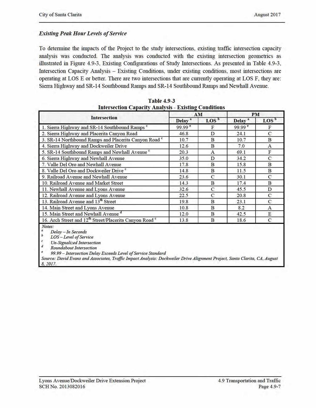
3 City of Santa Clarita August 2017 Study Intersections A total of seventeen study intersections have been identified for analysis based on potential traffic impacts to the area roadways. Figure shows the locations of the study intersections. The intersections identified for analysis are as follows: 1. Sierra Highway and SR-14 Freeway Southbound Ramps 2. Sierra Highway and Placerita Canyon Road 3. SR-14 Freeway Northbound Ramps and Placerita Canyon Road 4. Sierra Highway and Dockweiler Drive 5. SR-14 Freeway Southbound Ramps and Newhall Avenue 6. Sierra Highway and Newhall Avenue 7. Valle Del Oro and Newhall Avenue 8. Valle Del Oro and Dockweiler Drive 9. Railroad Avenue and Newhall Avenue 10. Railroad Avenue and Market Street 11. Newhall Avenue and Lyons Avenue 12. Railroad Avenue and Lyons Avenue 13. Railroad Avenue and 13 th Street 14. Main Street and Lyons Avenue 15. Main Street and Newhall Avenue 16. Arch Street and 12 th Street/Placerita Canyon Road 17. Lyons Avenue and Dockweiler Drive (This intersection is a future intersection) Existing Intersection Conditions Existing Traffic Volumes As referenced from the City of Santa Clarita Circulation Element, Average Daily Traffic (ADT) is a measurement of the average number of vehicles that travel a segment of roadway during a 24-hour period. The ADT is a useful benchmark for determining roadway capacities. Figure illustrates the existing street system ADT and intersection locations. Figure illustrates the existing peak hour traffic volumes in the study area. As referenced from the City of Santa Clarita Circulation Element, Peak hour information, which is the highest volume of traffic to pass over a road in a one-hour period, allows for a more detailed method of evaluating traffic conditions along roadways and intersections, and is used whenever operational analysis is required. The traffic volume data used in the intersection capacity analysis were based on traffic counts conducted by Newport Traffic Studies, an independent traffic data collection company. Turn movement counts were collected during the AM (7-9 AM) and PM (4-6 PM) peak periods at the above-mentioned existing intersections identified for detailed analysis. These counts were conducted in December The resulting turning movement volumes are presented in the Intersection Capacity Analysis Appendix of the Traffic Study. Lyons Avenue/Dockweiler Drive Extension Project 4.9 Transportation and Traffic SCH No Page 4.9-3
4
5
6
7
8
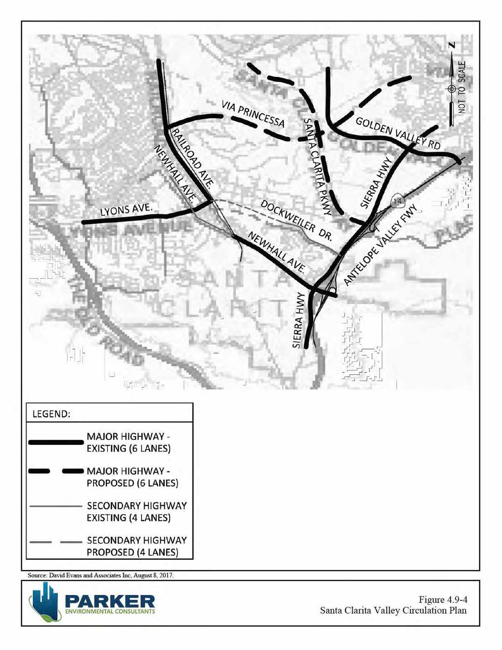
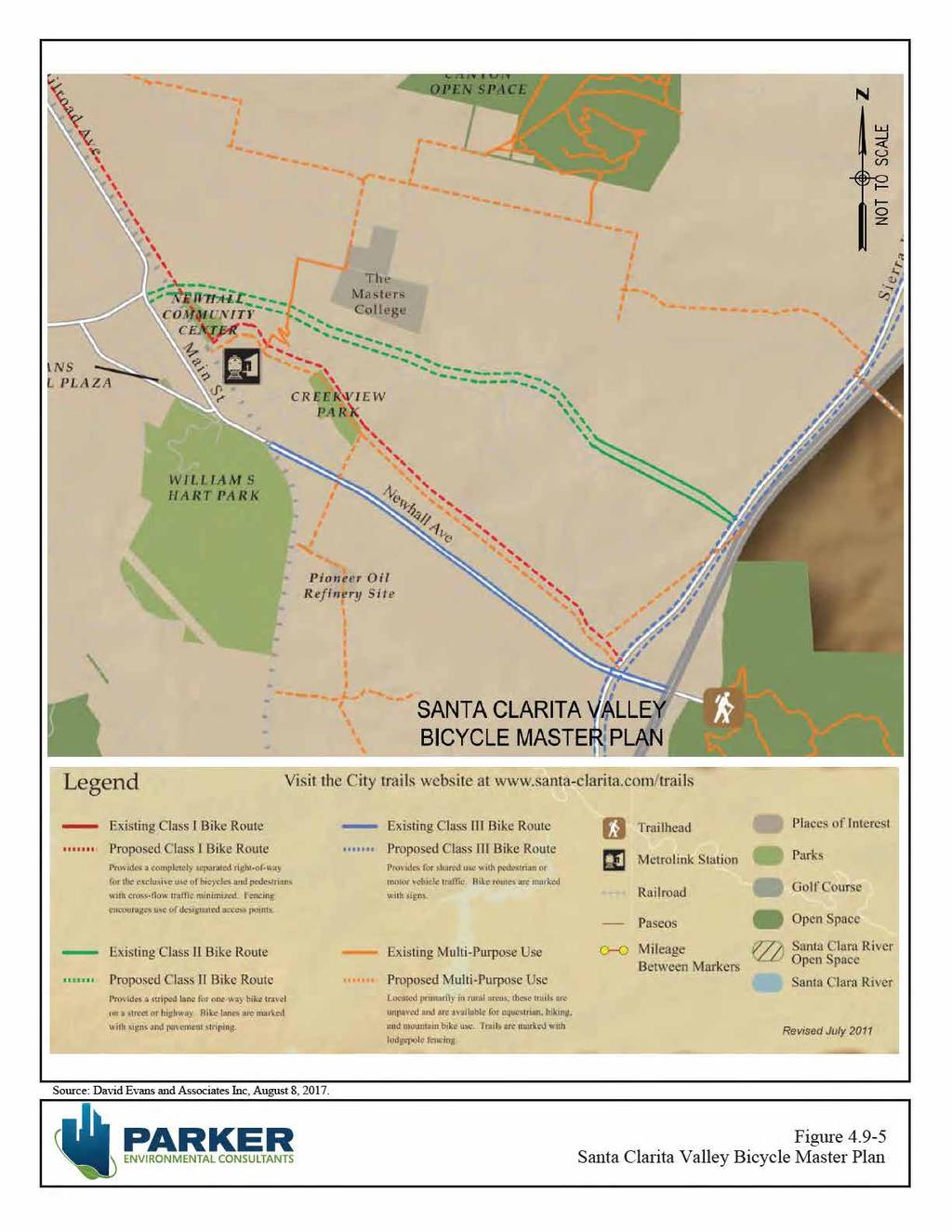
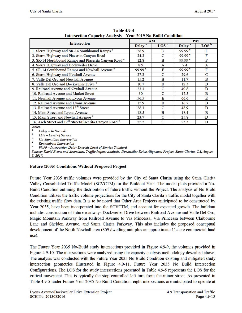
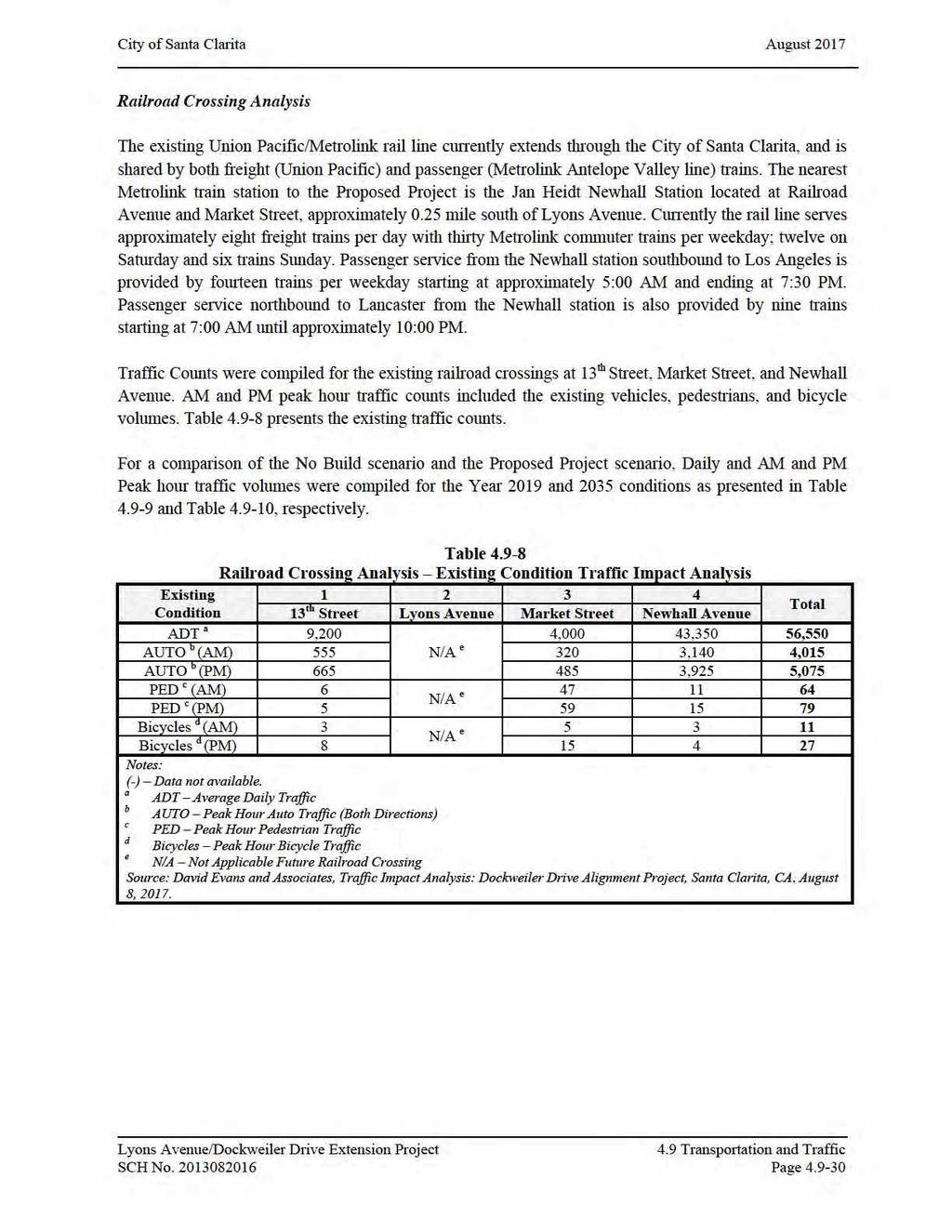
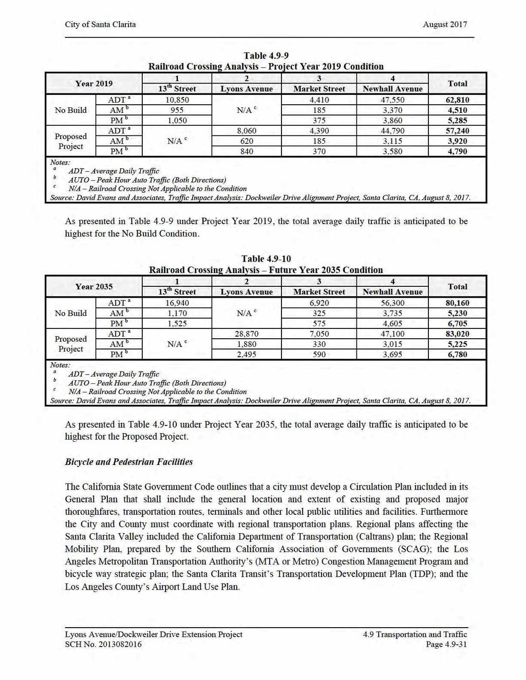
9 City of Santa Clarita August 2017 Existing Transit Service The Santa Clarita Valley s circulation system is a comprehensive transportation network of roadways, multi-use trails, bicycle paths, bus transit, and commuter rail. This network provides mobility options to Santa Clarita Valley residents and businesses. Figure illustrates the portion of the Santa Clarita Valley Circulation Plan bounded by the study area. A major component in the development of the Santa Clarita Valley is the inclusion of alternative travel modes and support facilities. These facilities include efficiency and capacity of existing systems, by promoting mixed-use development near transit facilities. Bicycle lanes and accessibility of bike paths are a fundamental component to a comprehensive transportation network. Figure illustrates a portion of the Santa Clarita Valley s Bicycle Master Plan bounded by the study area. Opening Year (2019) Conditions Without Proposed Project A Project year of 2019 has been identified as the opening year for the Dockweiler Drive Alignment Project. A major factor in distribution of traffic is the anticipated growth within the study area due to development. The Year 2019 traffic volumes were provided by the City of Santa Clarita using the Santa Clarita Valley Consolidated Traffic Model (SCVCTM) for the Interim Year. It is to be noted that Other Area Projects anticipated to be constructed by Year 2019, have been incorporated into the SCVCTM, and account for expected growth. The Santa Clarita Valley Consolidated Traffic Model (SCVCTM) for Interim Year provided traffic volumes for the Project Year 2019 Condition. The model plots provided a No-Build Condition outlining the distribution of future traffic without the Project. The Project Year 2019 No-Build study intersections are provided in Figure and the volumes are provided in Figure The intersections were analyzed using the capacity analysis methodology described in the above. The analysis was conducted with the existing intersection geometrics illustrated in Figure The LOS for the study intersections presented in Table represents the LOS for the critical movement. This is typically the stop controlled left turn from the minor street. As presented in Table under Year 2019 No-Build Condition, most of the study intersections are anticipated to continue to operate at LOS E or better. There are four intersections that are anticipated to operate at LOS F, they are: Sierra Highway and SR-14 Southbound Ramps, Sierra Highway and Placerita Canyon Road, SR-14 Northbound Ramps and Placerita Canyon Road, and SR-14 Southbound Ramp and Newhall Avenue. Lyons Avenue/Dockweiler Drive Extension Project 4.9 Transportation and Traffic SCH No Page 4.9-9
10
11
12
13
14
15
16
17
18
19
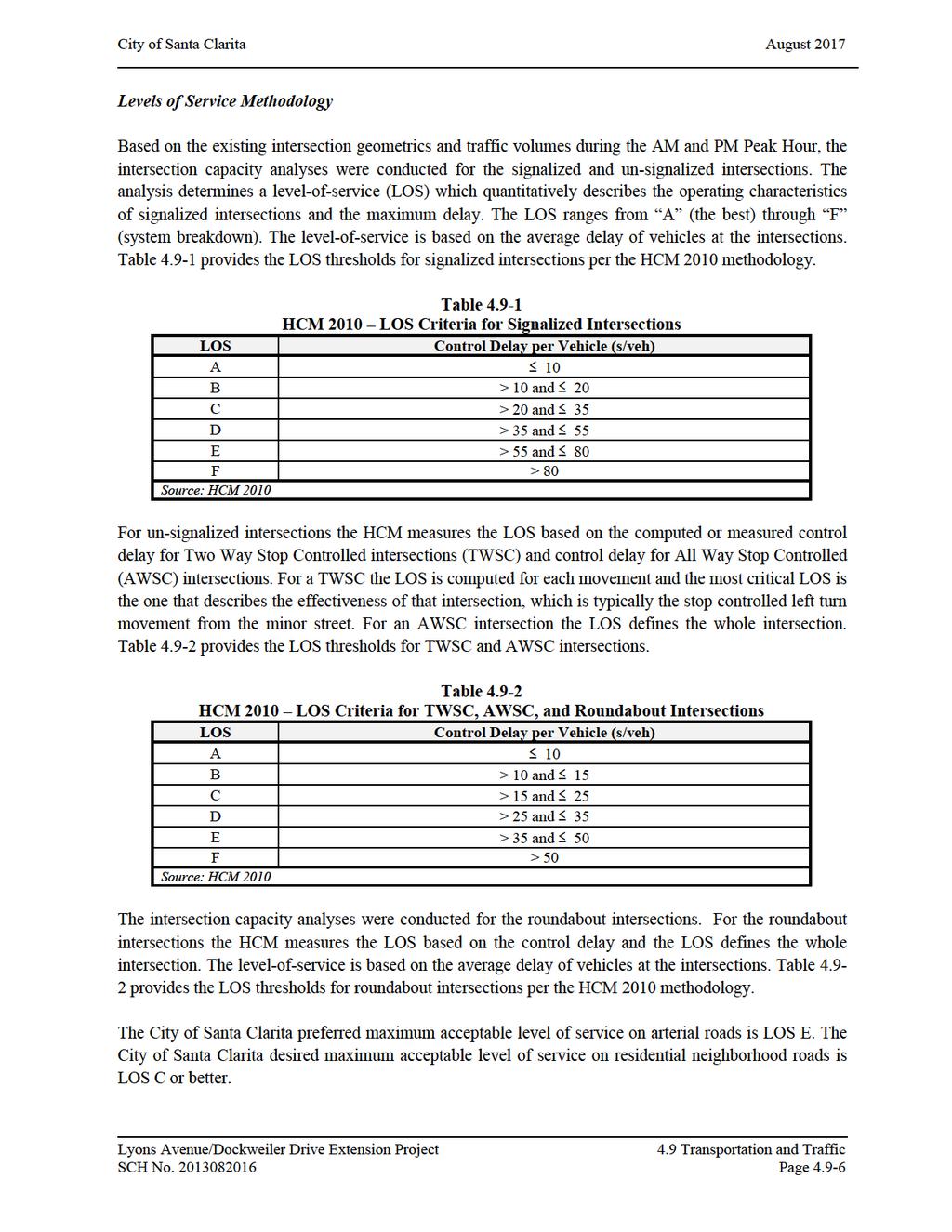
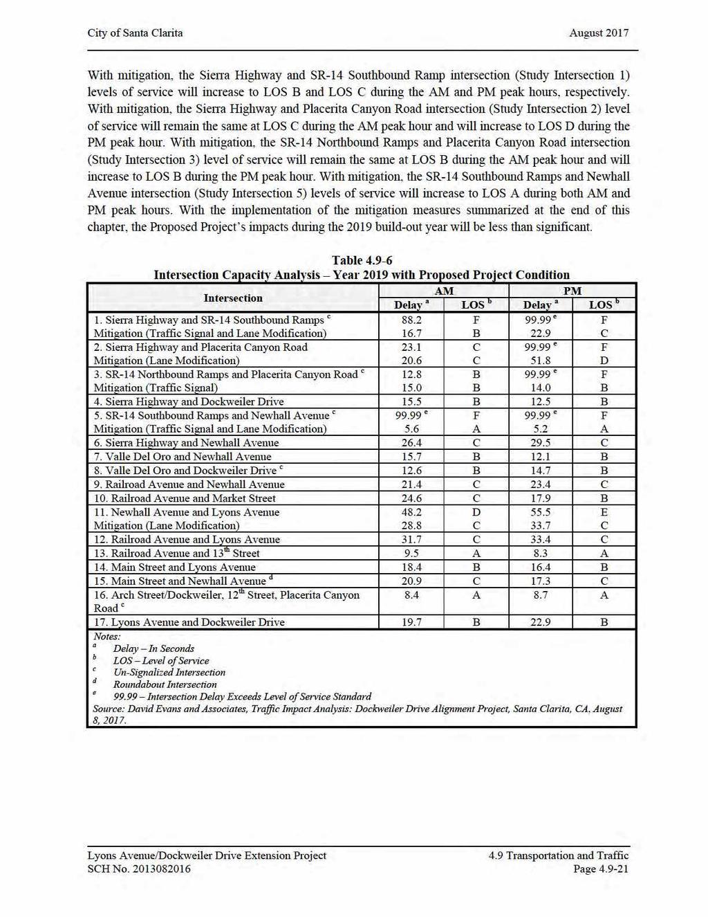
20 City of Santa Clarita August ENVIRONMENTAL IMPACTS Thresholds of Significance A project would normally have a significant impact on intersection capacity if the operation of the project causes an increase in the control delay per vehicle for a given intersection s operating condition. As discussed above, the LOS ranges from A (the best) through F (system breakdown). The level-ofservice is based on the average delay of vehicles at the intersections. View Tables and 4.9-2, for the LOS criteria for signalized intersections and unsignalized intersections, respectively. The City of Santa Clarita preferred maximum acceptable level of service on arterial roads is LOS E. The City of Santa Clarita desired maximum acceptable level of service on residential neighborhood roads is LOS C or better. Project Impacts Opening Year (2019) Conditions With Proposed Project The Santa Clarita Valley Consolidated Traffic Model (SCVCTM) for Interim Year provided traffic volumes for the Project Year 2019 with Proposed Project Condition. The model plots outlined the distribution of future traffic with the construction of the Proposed Project. The Project Year 2019 Proposed Project study intersections are provided in Figure , and the volumes provided in Figure The analysis for the intersection of Arch Street/Dockweiler Drive and 12 th Street/Placerita Canyon Road was conducted as a 5-leg all way stop controlled intersection. The analysis for the intersection of Lyons Avenue and Dockweiler Drive was conducted as a signalized intersection. The railroad crossing at the intersection of Railroad Avenue and 13 th Street is proposed to be closed. The intersection will be modified, removing the northbound right turn lane and southbound left turn lane and restricting the eastbound through movement. The intersections were analyzed using the capacity analysis methodology described above. The analysis was conducted with the Project Year 2019 with Proposed Project existing and mitigated study intersection geometrics illustrated in Figure The LOS for the study intersections presented in Table represents the LOS for the critical movement. This is typically the stop controlled left turn from the minor street. As presented in Table under Year 2019 with Project Proposed Condition, most of the study intersections are anticipated to continue to operate at LOS E or better. There are four intersections that are anticipated to operate at LOS F, they are: Sierra Highway and SR-14 Southbound Ramps, Sierra Highway and Placerita Canyon Road, SR-14 Northbound Ramps and Placerita Canyon Road, SR-14 Southbound Ramps and Newhall Avenue. Mitigation measures are necessary to accommodate the anticipated Year 2019 traffic and reduce potential Project impacts. Lyons Avenue/Dockweiler Drive Extension Project 4.9 Transportation and Traffic SCH No Page
21
22
23
24
25 City of Santa Clarita August 2017 Future (2035) Conditions With Proposed Project The Santa Clarita Valley Consolidated Traffic Model (SCVCTM) for Build-Out Year provided traffic volumes for the Future Year 2035 with Proposed Project Condition. The model plots outlined the distribution of future traffic with the construction of the Proposed Project. The analysis of Proposed Project utilizes the traffic volume projections for the City of Santa Clarita s traffic model together with the existing traffic flow data. The traffic projections are based on the General Plan Buildout. The buildout includes construction of future roadways Dockweiler Drive between Railroad Avenue and Valle Del Oro,, Magic Mountain Parkway from Railroad Avenue to Via Princessa, and Via Princessa between Claibourne Lane and Sheldon Avenue. This also includes the proposed conceptual development of the North Newhall area (809 dwelling unit plus an approximate 11-acre commercial land use). The Future Year 2035 Proposed Project study intersections provided in Figure , the volumes provided in Figure The intersections were analyzed using the capacity analysis methodology described above. The analysis was conducted with the Future Year 2035 Proposed Project Condition existing and mitigated study intersection geometrics illustrated in Figure The LOS for the study intersections presented in Table represents the LOS for the critical movement. This is typically the stop controlled left turn from the minor street. As presented in Table under Future Year 2035 with Proposed Project Condition, most of the study intersections are anticipated to continue to operate at LOS E or better. There are four intersections that are anticipated to operate at LOS F, they are: Sierra Highway and Placerita Canyon Road, Sierra Highway and Newhall Avenue, Valle Del Oro and Dockweiler Drive, and Main Street and Newhall Avenue. Mitigation measures are necessary to accommodate the anticipated Future Year 2035 traffic and reduce potential Project impacts. With mitigation, the Sierra Highway and Placerita Canyon Road intersection (Study Intersection 2) levels of service will increase to LOS D during both AM and PM peak hours. With mitigation, the Sierra Highway and Newhall Avenue intersection (Study Intersection 6) levels of service will increase from LOS E to LOS D during the AM peak hour and LOS F to LOS D during the PM peak hour. With mitigation, the Valle Del Oro and Dockweiler Drive intersection (Study Intersection 8) levels of service will increase to LOS C and LOS D during the AM and PM peak hours, respectively. With mitigation, the Main Street and Newhall Avenue intersection (Study Intersection 15) levels of service will increase from LOS F to LOS B during the AM peak hour and LOS E to LOS A during the PM peak hour. With the implementation of the mitigation measures summarized at the end of this chapter, the Proposed Project s impacts during the 2035 year will be less than significant. Lyons Avenue/Dockweiler Drive Extension Project 4.9 Transportation and Traffic SCH No Page
26
27
28
29
30
31
32 City of Santa Clarita August 2017 The Santa Clarita Valley s circulation system provides vital connections linking neighborhoods, services, and employment centers throughout the community and the region. A comprehensive transportation network of roadways, multi-use trails and bicycle paths, bus transit, and commuter rail provides mobility options to Valley residents and businesses. Planning for the ultimate location and capacity of circulation improvements will also enhance economic strength and quality of life in the Valley. Consideration to the Santa Clarita Valley s continued development of efficient, cost-effective and comprehensive transportation systems that are consistent with regional plans, and local needs. The Circulation Plan identifies and promotes a variety of techniques for improving mobility that go beyond planning for construction of new streets and highways. A major component in the development of the Santa Clarita Valley is the inclusion of alternative travel modes and support facilities. These facilities increase efficiency and capacity of existing systems, by promoting mixed-use development near transit facilities. Bicycle lanes and accessibility to bicycle paths are fundamental to a comprehensive transportation network. The Santa Clarita Valley s Bicycle and Pedestrian Facilities is provided in Figure As illustrated in Figure , Potential Bike Lane connectors are proposed from Dockweiler Drive to connect to the Proposed Class I Bike Path along Railroad Avenue and the Proposed Class II Bike Path along Dockweiler Drive. Vehicle Miles Traveled California s Sustainable Communities and Climate Protection Act, also referred to as Senate Bill 375 (SB 375) became effective January 1, The goal of SB 375 is to help achieve AB 32 s GHG emissions reduction goals by aligning the planning processes for regional transportation, housing, and land use. SB 375 requires CARB to develop regional reduction targets for GHGs, and prompts the creation of regional plans to reduce emissions from vehicle use throughout the state. California s 18 Metropolitan Planning Organizations (MPOs) have been tasked with creating Sustainable Community Strategies (SCS) in an effort to reduce the region s vehicle miles traveled (VMT) in order to help meet AB 32 targets through integrated transportation, land use, housing and environmental planning. On April 6, 2016, SCAG s Regional Council adopted the Regional Transportation Plan/Sustainable Communities Strategy: Towards a Sustainable Future ( RTP/SCS). The SCAG 2016 RTP/SCS is an update to the RTP/SCS that further integrates land use and transportation in certain areas so that the region as a whole can grow smartly and sustainably. Between 2015 and 2040, the SCAG region is anticipated to experience increases in population, households and jobs. The 2016 RTP/SCS includes land use strategies, based on local general plans, as well as input from local governments, to achieve the AB 32 state-mandated reductions in GHG emissions through decreases in regional per capita VMT. As part of the RTP/SCS, transportation network improvements would be included, and more compact, infill, walkable and mixed-use development strategies to accommodate new region s growth would be encouraged to accommodate increases in population, households, employment, and travel demand. Lyons Avenue/Dockweiler Drive Extension Project 4.9 Transportation and Traffic SCH No Page
33
34 City of Santa Clarita August 2017 The Proposed Dockwelier Drive Extension Project is identified as one of the financially constrained projects within the RTP/SCS, as shown in Appendix B, 2016 RTP/SCS Project List. 1 As such, the project is recognized as part of the regional strategy that is consistent with SCAG s policies to reduce VMTs. The Proposed Project is also identified in the City s Circulation Element as an addition route of travel connecting Lyons Avenue to Dockweiler Drive. Because no new land uses are being proposed, the Proposed Project would not generate any new vehicle trips and thus would not have the potential to increase VMTs on a per capita basis CUMULATIVE IMPACT Development of the Proposed Project in conjunction with the related projects would increase the amount of traffic in the Proposed Project area within the City of Santa Clarita. Cumulative traffic impacts are addressed by comparing the Existing Conditions as presented in the Environmental Setting portion of this Section, to the Future with Project for 2019 and 2035 (which includes the Proposed Project plus ambient and related project growth), as presented in the Project Impacts portion of this Section. As discussed under Project Impacts, the Proposed Project would not result in a significant impact at any of the analyzed intersections in the study area with the incorporation of mitigation measures. With respect to traffic from each of the related projects, mitigation measures for each related project would be implemented individually in coordination with the Lead Agency. The Proposed Project would not result in a significant impact related to traffic, emergency access, design hazards, or alternative modes of transportation that currently serve the Project area. With respect to each of these areas, the design of each related project would be evaluated individually in coordination with the appropriate Lead Agency department to minimize any potential impacts. Overall, the Proposed Project s cumulative transportation and traffic impacts would be less than significant MITIGATION MEASURES Year 2019 Project Mitigation Measures Dockweiler Drive extension: Construct to full Secondary Highway Pavement width, from Aden Avenue to west of Valle Del Oro, providing two lanes eastbound (uphill) and one lane westbound (downhill), as necessary. May be striped for parking lane on both sides of roadway in interim condition. Class II Bike lanes and Pedestrian Sidewalks to be provided Railroad Avenue (North-South) and Lyons Avenue (East-West): Construct the railroad crossing and improve the intersection. The intersection improvements will include widening the northbound direction to accommodate an additional left turn lane and convert a through lane to a shared through-right lane and southbound direction to accommodate and additional left turn lane and convert the right turn lane to a shared through-right turn lane. The north and southbound directions will include two left turn lanes, a through lane, and a shared through-right turn lane. The eastbound direction will provide a left turn lane, a through lane, and a shared through-right turn lane. The westbound direction will provide a left turn lane, two through lanes and a right turn lane. 1 See RTP/SCS, Appendix B, Table 2, at page 151. Lyons Avenue/Dockweiler Drive Extension Project 4.9 Transportation and Traffic SCH No Page
35 City of Santa Clarita August Arch Street (north leg) / Dockweiler Drive (south leg) / 12 th Street (east and west legs) / Placerita Canyon Road (southeast leg): Convert intersection to a 5-leg all way stop controlled intersection including Dockweiler Drive as the 5th leg. Arch Street will include a shared left-through-right lane accommodating left turning movements to the west leg (12 th Street) and Placerita Canyon Road. Dockweiler Drive will include a shared left-through right lane accommodating right turning movements to Placerita Canyon Road and the west leg (12 th Street). The east leg (12 th Street) will include a shared left-through-right lane accommodating left turning movements to Placerita Canyon Road and Dockweiler Drive. The west leg (12 th Street) will include a shared left-through-right lane accommodating right turning movements to Dockweiler Drive and Placerita Canyon Road. Placerita Canyon Road will include a shared left-right lane accommodating left turning movements to Dockweiler Drive and west leg (12 th Street) and right turning movements to the east leg (12 th Street) and Arch Street Lyons Avenue (North-South) and Dockweiler Drive (East-West): Extend Lyons Avenue to intersect with Dockweiler Drive as a signalized T-intersection. The northbound direction will include two left turn lanes and a through lane. The southbound direction will include a through and two right turn lanes. The eastbound direction will include a left turn lane and two right turn lanes Railroad Avenue (North-South) and 13 th Street (East-West): The railroad crossing to be closed. The intersection modifications include removing the northbound right turn lane and southbound left turn lane and restricting the eastbound through movement. The northbound direction will include a left turn lane and two through lanes. The southbound direction will include a through lane and a shared through-right turn lane. The eastbound direction will include a shared left-right turn lane. Year 2019 Regional Mitigation Measures Sierra Highway (North-South) and SR-14 Freeway Southbound Ramps (East-West): The intersection modifications include installing a traffic signal and widening the southbound direct to provide an additional left turn lane. The northbound direction will include a through lane, and a shared through-right turn lane. The southbound direction will include two left turn lanes, and two through lanes. The eastbound direction will include a left turn lane and a right turn lane Sierra Highway (North-South) and Placerita Canyon Road (East-West): The intersection modifications include lane modifications to provide an exclusive right turn westbound lane and right turn northbound lane. The northbound direction will include a left turn lane, two through lanes, and a right turn lane. The south and eastbound directions will include a left turn lane, a through lane, and a shared through-right turn lane. The westbound direction will include a left turn lane, a through lane, and a right turn lane SR-14 Freeway Northbound Ramps (North-South) and Placerita Canyon Road (East-West): The intersection modifications include installing a traffic signal. The northbound direction will include a left turn lane and a right turn lane. The east and westbound directions will include two through lanes. Lyons Avenue/Dockweiler Drive Extension Project 4.9 Transportation and Traffic SCH No Page
36 City of Santa Clarita August SR-14 Freeway Southbound Ramps (North-South) and Newhall Avenue (East-West): The intersection modifications include converting the east and southbound right turn lanes to free right turns and signalizing the intersection. The eastbound direction will include two through lanes and a free right turn lane. The southbound direction will include a shared through-left turn lane and a free right turn lane. The westbound direction will include a left turn lane and two through lanes Newhall Avenue (North-South) and Lyons Avenue (East-West): The intersection modifications include converting the eastbound through-right lane to a right turn lane. The northbound direction will include two left turn lanes and a shared through-right lane. The southbound direction will include a left turn lane and a shared through-right lane. The east and westbound directions will include a left turn lane, two through lanes, and a right turn lane. Year 2035 Project Mitigation Measures Valle Del Oro (North-South) and Dockweiler Drive (East-West): Install a traffic signal. The Intersection modifications include signalizing the intersection and widening the east and west bound direction to accommodate an additional through lane and widening the northbound direction to accommodate an exclusive right turn lane. The northbound direction will include a shared left-through lane and a right turn lane. The southbound direction will include a shared left-through-right turn lane. The east and westbound directions will include a left turn lane, a through, and a shared through-right turn lane. Year 2035 Regional Mitigation Measures Sierra Highway (North-South) and Placerita Canyon Road (East-West): The Intersection modifications include widening to accommodate lane modifications to all approaches. Widen the northbound direction to accommodate an additional through lane. Widen the east and southbound directions to accommodate two additional through lanes and restripe the shared through-right lane to a right turn only lane. Widen the westbound direction to accommodate two additional through lanes. The north, east, south, and westbound direction will include a left turn lane, three through lanes, and a right turn lane Sierra Highway (North-South) and Newhall Avenue (East-West): Intersection modifications include converting the northbound through-right turn lane to a through lane and widening to accommodate a free right turn. The northbound direction will include two left turn lanes, two through lanes, and a free right turn. The southbound direction will include a left turn lane, two through lanes, and a shared through-right turn lane. The east and westbound directions will include two left turn lane, three through lanes, and a right turn lane Main Street (north leg) / Newhall Avenue (south leg) / Newhall Avenue (west leg): The intersection modifications include widening the northbound direction to accommodate a left turn lane and the eastbound direction to accommodate a right turn lane. Newhall Avenue (south leg) will include a left turn lane and a shared left-through lane. Main Street will include a shared right-through lane. Newhall Avenue (east leg) will include a shared left-right lane and a right Lyons Avenue/Dockweiler Drive Extension Project 4.9 Transportation and Traffic SCH No Page
37 City of Santa Clarita August 2017 turn lane LEVEL OF SIGNIFICANCE AFTER MITIGATION With the incorporation of mitigation measures, impacts upon transportation and circulation system would be less than significant. Lyons Avenue/Dockweiler Drive Extension Project 4.9 Transportation and Traffic SCH No Page
Lyons Avenue/Dockweiler Road Extension Project Draft Environmental Impact Report. Appendix I Traffic Impact Study
 Lyons Avenue/Dockweiler Road Extension Project Draft Environmental Impact Report Appendix I Traffic Impact Study Street 0 80-1947 500.4501 RITA ld Court 0 91355-1096 400.7401 LA n Avenue 0 590-3745 300-9301
CarMax Auto Superstore/ Reconditioning Center #6002 Murrieta, California
 CarMax Auto Superstore/ Reconditioning Center #6002 Murrieta, California TUSTIN 17782 17th Street Suite 200 Tustin, CA 92780-1947 714.665.4500 Fax: 714.665.4501 LOS ANGELES 145 S. Spring Street Suite 120
MOUNTAIN HOUSE SPECIFIC PLAN I 9.1 INTRODUCTION ASSUMPTIONS TRANSPORTATION FACILITIES TRANSPORTATION IMPROVEMENTS PHASING 9.
 CHAPTER NINE: TRANSPORTATION AND CIRCULATION 9.1 INTRODUCTION 9.1 9.2 ASSUMPTIONS 9.1 9.3 TRANSPORTATION FACILITIES 9.1 9.4 TRANSPORTATION IMPROVEMENTS PHASING 9.3 LIST OF FIGURES LIST OF TABLES Figure
4.10 TRANSPORTATION AND CIRCULATION
 4.10 TRANSPORTATION AND CIRCULATION PURPOSE The section discusses the potential impacts to traffic and circulation as a result of the implementation of the proposed Via Princessa East Extension, which
APPENDIX G: INTERSECTION NEEDS AT OKEECHOBEE BOULEVARD
 APPENDIX G: INTERSECTION NEEDS AT OKEECHOBEE BOULEVARD INTERSECTION NEEDS AT SR 7 and OKEECHOBEE BOULEVARD SR 7 Extension Project Development and Environment (PD&E) Study From Okeechobee Boulevard (SR
Appendix C. NORTH METRO STATION AREA TRAFFIC IMPACT STATEMENT 88th Avenue Station
 Appendix C NORTH METRO STATION AREA TRAFFIC IMPACT STATEMENT 88th Avenue Station Prepared for: Regional Transportation Department and URS Corporation as part of the North Metro EIS David Evans and Associates,
5.3 TRAFFIC, CIRCULATION AND PARKING
 5.3 TRAFFIC, CIRCULATION AND PARKING This section is based upon the Downtown Lancaster Specific Plan Traffic Impact Analysis (April 2, 2008) and the Downtown Lancaster Specific Plan Parking Analysis (May
I-105 Corridor Sustainability Study (CSS)
") I-105 Corridor Sustainability Study (CSS) Metro Streets and Freeways Subcommittee March 21, 2019 Gary Hamrick Cambridge Systematics, Inc. I-105 CSS Project History & Background Funded by Caltrans Sustainable
I-105 Corridor Sustainability Study (CSS) Metro Streets and Freeways Subcommittee March 21, 2019 Gary Hamrick Cambridge Systematics, Inc. I-105 CSS Project History & Background Funded by Caltrans Sustainable
APPENDIX H TRAFFIC REPORT
 APPENDIX H TRAFFIC REPORT Keith Higgins Traffic En ginee r WEST END SAND CITY TRAFFIC IMPACT ANALYSIS DRAFT REPORT SAND CITY, CALIFORNIA Prepared for DBO Development No. 3 Monterey, CA Prepared by Keith
Basalt Creek Transportation Refinement Plan Recommendations
 Basalt Creek Transportation Refinement Plan Recommendations Introduction The Basalt Creek transportation planning effort analyzed future transportation conditions and evaluated alternative strategies for
MCTC 2018 RTP SCS and Madera County RIFP Multi-Modal Project Eval Criteria GV13.xlsx
 MCTC 8 RTP SCS and Madera County RIFP Multi-Modal Project Eval Criteria GV.xlsx Madera County Transportation Commission Regional Transportation Plan / Sustainable Communities Strategy Multi-Modal Project
3.9 - Transportation and Traffic
 Transportation and Traffic 3.9 - Transportation and Traffic This section describes the potential transportation and traffic effects of project implementation on the project site and its surrounding area.
General Plan Circulation Element Update Scoping Meeting April 16, 2014 Santa Ana Senior Center, 424 W. 3rd Street, Santa Ana, CA 92701
 General Plan Circulation Element Update Scoping Meeting April 16, 2014 Santa Ana Senior Center, 424 W. 3rd Street, Santa Ana, CA 92701 Meeting Agenda 1. Purpose of Scoping Meeting 2. Project Overview 3.
DRAFT BUENA VISTA 2020 TRANSPORTATION PLAN
 DRAFT BUENA VISTA 2020 TRANSPORTATION PLAN DEVELOPED BY THE TRANSPORTATION PLANNING DIVISION OF THE VIRGINIA DEPARTMENT OF TRANSPORTATION IN COOPERATION WITH THE U.S. DEPARTMENT OF TRANSPORTATION, FEDERAL
Los Altos Hills Town Council - June 18, 2015 Palo Alto City Council June 22, AGENDA ITEM #2.B Presentation
 Los Altos Hills Town Council - June 18, 2015 Palo Alto City Council June 22, 2015 AGENDA ITEM #2.B Presentation Previous Presentations Los Altos Hills Town Council in May 2014 and February 2015 Palo Alto
University Hill Transportation Study Technical Memorandum Alternatives Modeling and Analysis May 2007
 Technical Memorandum May 2007 Syracuse Metropolitan Transportation Council Edwards and Kelcey with Wallace Roberts and Todd Alta Planning and Design CONTENTS SECTION ONE- INTRODUCTION...1 SECTION TWO-
This chapter describes the proposed circulation system and transportation alternatives associated with
 5.0 Circulation 5.1 OVERVIEW This chapter describes the proposed circulation system and transportation alternatives associated with West Landing, and summarize the information contained in the Existing
DUNBOW ROAD FUNCTIONAL PLANNING
 DUNBOW ROAD FUNCTIONAL PLANNING Final Report August 3, 216 #31, 316 5th Avenue NE Calgary, AB T2A 6K4 Phone: 43.273.91 Fax: 43.273.344 wattconsultinggroup.com Dunbow Road Functional Planning Final Report
1. What is the Doran Street and Broadway/Brazil Grade Separation Project (Project)?
?") 1. What is the Doran Street and Broadway/Brazil Grade Separation Project (Project)? The Los Angeles County Metropolitan Transportation Authority (Metro) is evaluating the development of a grade separation
1. What is the Doran Street and Broadway/Brazil Grade Separation Project (Project)? The Los Angeles County Metropolitan Transportation Authority (Metro) is evaluating the development of a grade separation
Magnolia Place. Traffic Impact Analysis. Prepared for: City of San Mateo. Prepared by: Hexagon Transportation Consultants, Inc.
 Magnolia Place Traffic Impact Analysis Prepared for: City of San Mateo Prepared by: Hexagon Transportation Consultants, Inc. Updated January 4, 2010 Table of Contents 1. Introduction...1 2. Existing Conditions...6
Figure 1: East West Connector Alignment Alternatives Concept Drawing
 Page 2 of 9 Figure 1: East West Connector Alignment Alternatives Concept Drawing The Montebello Drive extension will run north south and connect Wilsonville Road to the Boones Ferry Road to Brown Road
Clackamas County Comprehensive Plan
 ROADWAYS The County s road system permits the movement of goods and people between communities and regions, using any of a variety of modes of travel. Roads provide access to virtually all property. They
TRASBURG RANSPORTATION
 TRASBURG RANSPORTATION LAN DEVELOPED BY THE TRANSPORTATION PLANNING DIVISION OF THE VIRGINIA DEPARTMENT OF TRANSPORTATION IN COOPERATION WITH THE U.S. DEPARTMENT OF TRANSPORTATION, FEDERAL HIGHWAY ADMINISTRATION
City of Wayzata Comprehensive Plan 2030 Transportation Chapter: Appendix A
 A1. Functional Classification Table A-1 illustrates the Metropolitan Council s detailed criteria established for the functional classification of roadways within the Twin Cities Metropolitan Area. Table
EXECUTIVE SUMMARY... vii 1 STUDY OVERVIEW Study Scope Study Area Study Objectives
 Contents EXECUTIVE SUMMARY... vii 1 STUDY OVERVIEW... 1-1 1.1 Study Scope... 1-1 1.2 Study Area... 1-1 1.3 Study Objectives... 1-3 2 EXISTING CONDITIONS... 2-1 2.1 Existing Freeway Conditions... 2-4 2.1.1
Circulation and Parking
 CHAPTER 6 Circulation and Parking A. Introduction This chapter describes the circulation recommendations for the Downtown Hemet Specific Plan, which includes recommendations for improving the roadway network,
TRAFFIC IMPACT STUDY CRITERIA
 Chapter 6 - TRAFFIC IMPACT STUDY CRITERIA 6.1 GENERAL PROVISIONS 6.1.1. Purpose: The purpose of this document is to outline a standard format for preparing a traffic impact study in the City of Steamboat
Highway 111 Corridor Study
 Highway 111 Corridor Study June, 2009 LINCOLN CO. HWY 111 CORRIDOR STUDY Draft Study Tea, South Dakota Prepared for City of Tea Sioux Falls Metropolitan Planning Organization Prepared by HDR Engineering,
C C C
 C-012-001 Thank you for your support for the creation of new public space and nonmotorized access between downtown and the waterfront through the Overlook Walk, the East-West Connections, and the Promenade.
Route 7 Corridor Study
 Route 7 Corridor Study Executive Summary Study Area The following report analyzes a segment of the Virginia State Route 7 corridor. The corridor study area, spanning over 5 miles in length, is a multi
D.13 Transportation and Traffic
 This section addresses transportation and traffic issues and impacts related to the Proposed Project. Section D.13.1 provides a description of the affected environment for the Proposed Project. Applicable
Chapter 6 Transportation Plan
 Chapter 6 Transportation Plan Transportation Plan Introduction Chapter 6 Transportation Plan Transportation Plan Introduction This chapter describes the components of Arvada s transportation system, comprised
V. ENVIRONMENTAL IMPACT ANALYSIS K. TRANSPORTATION AND CIRCULATION
 V. ENVIRONMENTAL IMPACT ANALYSIS K. TRANSPORTATION AND CIRCULATION ENVIRONMENTAL SETTING The following section is based on the Draft Traffic Circulation Study for the Malibu La Paz Project (Traffic Study),
Bridge Street Corridor Study Report
 Bridge Street Corridor Study Report Prepared for: Prepared by: BRIDGE STREET CORRIDOR STUDY REPORT PREPARED FOR: CITY OF ARROYO GRANDE COMMUNITY DEVELOPMENT DEPARTMENT 300 EAST BRANCH STREET ARROYO GRANDE,
Glenn Avenue Corridor Traffic Operational Evaluation
 Glenn Avenue Corridor Traffic Operational Evaluation PREPARED FOR: THE CITY OF AUBURN PREPARED BY: DECEMBER 2007 Glenn Avenue Corridor Study--Auburn, Alabama TABLE OF CONTENTS Introduction... 1 Background
1.0 INTRODUCTION 1.1 PURPOSE OF THIS REPORT
 1.0 INTRODUCTION This chapter provides an overview of the purpose, authorization and focus of this Recirculated Draft Environmental Impact Report (EIR), an identification of the Lead Agency, an outline
Section 3.5 Transportation and Traffic
 Section 3.5 Transportation and Traffic 3.5.1 Introduction This section presents the transportation and traffic analysis conducted for the proposed project. Pursuant to California Environmental Quality
Sixth Line Development - Transit Facilities Plan
 Memorandum Date: November 13, 2012 To: From: c.c. Subject: Rob Freeman (Freeman Planning) Kevin Phillips Sixth Line Development - Transit Facilities Plan 33016631 This memo was prepared to review the transit
The State General Plan Guidelines recommend that the circulation policies and plans should:
 Introduction Rancho Santa Margarita has a well-planned, well-developed circulation system consisting of arterial roadways and local streets. The Foothill Transportation Corridor (SR-241) provides regional
Highway 49, Highway 351 and Highway 91 Improvements Feasibility Study Craighead County
 Highway 49, Highway 351 and Highway 91 Improvements Feasibility Study Craighead County Executive Summary March 2015 Highway 49, Highway 351 and Highway 91 Improvements Feasibility Study Craighead County
HIGHBURY AVENUE/HAMILTON ROAD INTERSECTION IMPROVEMENTS PUBLIC INFORMATION CENTRE 1 MAY 14, 2015
 HIGHBURY AVENUE/HAMILTON ROAD INTERSECTION IMPROVEMENTS Municipal Class Environmental Assessment PUBLIC INFORMATION CENTRE 1 MAY 14, 2015 ACCESSIBILITY Under the Accessibility Standards 2015 for Customer
Transportation Impact Study for Abington Terrace
 Transportation Impact Study for Abington Terrace Abington Township, Montgomery County, PA Sandy A. Koza, P.E., PTOE PA PE License Number PE059911 Prepared by McMahon Associates, Inc. 425 Commerce Drive,
City of Memphis On-Street Parking Modification Guidelines
 City of Memphis Effective Date: December 1, 2013 Bicycle/Pedestrian Program 125 N. Main Street Memphis, TN 38103 (901) 576-6710 www.bikepedmemphis.com City of Memphis Executive Summary It is current practice
Chapter 4 Traffic Analysis
 Chapter 4 Traffic Analysis PURPOSE The traffic analysis component of the K-68 Corridor Management Plan incorporates information on the existing transportation network, such as traffic volumes and intersection
Circulation in Elk Grove includes: Motor vehicles, including cars and trucks
 Circulation, as it is used in this General Plan, refers to the many ways people and goods move from place to place in Elk Grove and the region. Circulation in Elk Grove includes: Motor vehicles, including
Lincoln Avenue Road Diet Trial
 Lincoln Avenue Road Diet Trial Data Collection Report June 1, 2015 Department of Transportation Table of Contents I. Introduction...... 3 II. Data Collection Methodology & Results...... 5 A. Traffic Volume
TRAFFIC IMPACT ANALYSIS
 TRAFFIC IMPACT ANALYSIS FOR THE CHAMPAIGN UNIT#4 SCHOOL DISTRICT PROPOSED HIGH SCHOOL (SPALDING PARK SITE) IN THE CITY OF CHAMPAIGN Final Report Champaign Urbana Urbanized Area Transportation Study 6/24/2014
WEST AND SOUTH WEST RING ROAD DOWNSTREAM TRAFFIC IMPACTS
 Page 1 of 9 EXECUTIVE SUMMARY Alberta Transportation ( AT ) is preparing to construct the final sections of the Calgary Ring Road. This includes the South West Ring Road ( SWRR ) (from Lott Creek Blvd
ONE VALLEY ONE VISION
 APPENDIX 3.2 One Valley One Vision Valley-wide Traffic Study, prepared byaustin-foust Associates, Inc.; dated June 2010 ONE VALLEY ONE VISION VALLEY-WIDE TRAFFIC STUDY TECHNICAL REPORT FOR THE CIRCULATION
REVIEW OF LOCAL TRAFFIC FLOW / LONG RANGE PLANNING SOLUTIONS STUDY
 ITEM Town of Atherton TRANSPORTATION COMMITTEE STAFF REPORT TO: FROM: MEMBERS OF THE COMMITTEE ROBERT OVADIA, PUBLIC WORKS DIRECTOR DATE: FEBRUARY 12, 2019 SUBJECT: REVIEW OF LOCAL TRAFFIC FLOW / LONG
Simulating Street-Running LRT Terminus Station Options in Dense Urban Environments Shaumik Pal, Rajat Parashar and Michael Meyer
 Simulating Street-Running LRT Terminus Station Options in Dense Urban Environments Shaumik Pal, Rajat Parashar and Michael Meyer Abstract The Exposition Corridor transit project is a light rail project
Solana Beach Comprehensive Active Transportation Strategy (CATS)
") Solana Beach Comprehensive Active Transportation Strategy (CATS) 3.0 Goals & Policies The Solana Beach CATS goals and objectives outlined below were largely drawn from the Solana Beach Circulation Element
Solana Beach Comprehensive Active Transportation Strategy (CATS) 3.0 Goals & Policies The Solana Beach CATS goals and objectives outlined below were largely drawn from the Solana Beach Circulation Element
Traffic Impact Analysis Chatham County Grocery Chatham County, NC
 Chatham County Grocery Chatham County, NC TABLE OF CONTENTS 1. INTRODUCTION... 1 1.1. Location and Study Area... 1 1.2. Proposed Land Use and Access... 2 1.3. Adjacent Land Uses... 2 1.4. Existing ways...
3.9 Recreational Trails and Natural Areas
 3.9 Recreational Trails and Natural Areas 3.9.1 Introduction Parks and other recreational facilities such as trails, bicycle routes, and open space are important community resources. This section discusses
TRAFFIC ACTION PLAN. North Central Neighborhood CITY OF SAN MATEO
 TRAFFIC ACTION PLAN North Central Neighborhood CITY OF SAN MATEO Draft February 2017 Table of Contents Introduction... 1 The Traffic Forum Process... 4 Neighborhood Traffic Issues... 6 Neighborhood Recommendations
Harrah s Station Square Casino
 Transportation Analysis Harrah s Station Square Casino Pittsburgh, Pennsylvania Submitted To: City of Pittsburgh and Pennsylvania Gaming Control Board Prepared By: DKS Associates GAI Consultants December
Preliminary Transportation Analysis
 Preliminary Transportation Analysis Goals of a Robust, Multimodal Transportation Network Safe Accessible/Connected Efficient Comfortable Context-Sensitive Motor Vehicle: Continue to analyze the data to
Summary: Mercer County Princeton Avenue & Spruce Street Study January 2009
 Summary: Several recent studies have assessed potential development and redevelopment opportunities in the Mercer Crossing area of Trenton, Ewing, and Lawrence. This Princeton Avenue and Spruce Street
ARTINSVILLE ENRY OUNTY REA RANSPORTATION TUDY
 ARTINSVILLE ENRY OUNTY REA RANSPORTATION TUDY DEVELOPED BY THE TRANSPORTATION AND MOBILITY PLANNING DIVISION OF THE VIRGINIA DEPARTMENT OF TRANSPORTATION IN COOPERATION WITH THE U.S. DEPARTMENT OF TRANSPORTATION,
DRAFT. Memo. Range of the Alternatives Considered in the EIS
 Memo Date: Friday, December 09, 2016 Project: To: From: Subject: State Route 30 EIS UDOT Vince Izzo This memorandum summarizes the draft State Route (S.R.) 30 Level 1 screening results. A more detailed
TRAFFIC STUDY GUIDELINES Clarksville Street Department
 TRAFFIC STUDY GUIDELINES Clarksville Street Department 9/1/2009 Introduction Traffic studies are used to help the city determine potential impacts to the operation of the surrounding roadway network. Two
Traffic Circulation Study for Neighborhood Southwest of Mockingbird Lane and Airline Road, Highland Park, Texas
 ARIZONA TEXAS NEW MEXICO OKLAHOMA February 13, 2015 Mr. Meran Dadgostar P.E., R.S. Town of Highland Park 4700 Drexel Dr. Highland Park, Texas 75205 Re: Traffic Circulation Study for Neighborhood Southwest
Intersection Traffic Control Feasibility Study
 Intersection Traffic Control Feasibility Study CSAH 9 at CSAH 60 (185th Avenue) Prepared For: Dakota County Transportation Department Western Service Center 14955 Galaxie Avenue, 3rd Floor Apple Valley,
List of Attachments. Location Map... Site Plan... City of Lake Elsinore Circulation Element... City of Lake Elsinore Roadway Cross-Sections...
 List of Attachments Exhibits Location Map... Site Plan... City of Lake Elsinore Circulation Element... City of Lake Elsinore Roadway Cross-Sections... Existing Lane Geometry and Traffic Controls... Existing
3.0 Future Conditions
 3.0 Future Conditions In order to be able to recommend appropriate improvements to the transportation system of the Town, it is important to first understand the nature and volume of traffic that is expected
LSC TRANSPORTATION CONSULTANTS, INC. 516 North Tejon Street Colorado Springs, CO (719) FAX (719)
 FAX (719)") LSC TRANSPORTATION CONSULTANTS, INC. 516 North Tejon Street Colorado Springs, CO 80903 (719) 633-2868 FAX (719) 633-5430 E-mail: lsc@lsccs.com May 15, 2009 Mr. Davis Farrar Western Slope Consulting, LLC
LSC TRANSPORTATION CONSULTANTS, INC. 516 North Tejon Street Colorado Springs, CO 80903 (719) 633-2868 FAX (719) 633-5430 E-mail: lsc@lsccs.com May 15, 2009 Mr. Davis Farrar Western Slope Consulting, LLC
Interchanges with Interstate 10 (I-10), I-15, and State Route 210 (SR-210) provide regional highway access to the planning area.
, I-15, and State Route 210 (SR-210) provide regional highway access to the planning area.") 5.13 TRANSPORTATION This section describes the transportation network and traffic conditions within the planning area and evaluates potential transportation impacts due to implementation of the General
5.13 TRANSPORTATION This section describes the transportation network and traffic conditions within the planning area and evaluates potential transportation impacts due to implementation of the General
 TRAFFIC IMPACT STUDY CANYON HILLS PROJECT LOS ANGELES, CALIFORNIA INTRODUCTION This traffic analysis has been conducted to identify and evaluate the potential traffic impacts of the proposed Canyon Hills
Improving Cyclist Safety at the Dundas Street West and Sterling Road Intersection
 STAFF REPORT ACTION REQUIRED Improving Cyclist Safety at the Dundas Street West and Sterling Road Intersection Date: August 17, 2012 To: From: Wards: Reference Number: Public Works and Infrastructure Committee
City of Homewood Transportation Plan
 City of Homewood Transportation Plan Prepared for: City of Homewood, Alabama Prepared by: Skipper Consulting, Inc. May 2007 TABLE OF CONTENTS INTRODUCTION... 1 BACKGROUND INFORMATION... 1 EXISTING TRANSPORTATION
Road Conversion Study Plumas Street
 Plumas Street Phase I Submitted to The Regional Transportation Commission of Washoe County Submitted by Zong Tian, Ph.D., P.E. Saeedeh Farivar Haiyuan Li, Ph.D. Center for Advanced Transportation Education
Reference number /VP. Lafayette Downtown Congestion Study - Additional Traffic Analysis
 To James Hinkamp and Tony Coe, City of Lafayette Date January 19, 2017 Copies Reference number 243381/VP From Michael Iswalt and Vanessa Peers File reference 4-05 Subject Lafayette Downtown Congestion
Arterial Management Plan for US Route 250 and State Route 623
 Arterial Management Plan for US Route 250 and State Route 623 June 25, 2014 Brad Shelton, AICP Access Management and Traffic Impact Analysis Programs Manager Transportation and Mobility Planning Division
MEMORANDUM INTRODUCTION/PURPOSE/OVERALL FINDINGS
 MEMORANDUM Date: To: From: Subject: Steve, City of Tacoma Dan Grayuski and Will Lisska, Fehr & Peers Schuster Corridor Trail Project SE12-0265.00 INTRODUCTION/PURPOSE/OVERALL FINDINGS The City of Tacoma
North County Metro. Community Summaries, Maps and Matrices
 North County Metro Interstate 15 Mountain Meadow Road / Mirar De Valle Road Deer Springs Road Overview Sponsor Group Preferences The North County Metro sub-region includes two represented communities:
CITY OF COCOA BEACH 2025 COMPREHENSIVE PLAN. Section VIII Mobility Element Goals, Objectives, and Policies
 CITY OF COCOA BEACH 2025 COMPREHENSIVE PLAN Section VIII Mobility Element Goals, Objectives, and Policies Adopted August 6, 2015 by Ordinance No. 1591 VIII MOBILITY ELEMENT Table of Contents Page Number
In station areas, new pedestrian links can increase network connectivity and provide direct access to stations.
 The Last Mile Planning for Pedestrians Planning around stations will put pedestrians first. Making walking to stations safe and easy is important; walking will be a part of every rapid transit Accessible
3.0 PROJECT DESCRIPTION
 The following section of the Draft EIR contains a description of the proposed Elk Grove Boulevard/SR 99 Interchange Modification project, consistent with the requirements of CEQA Guidelines Section 15124.
Giles Run Connector Road
 Giles Run Connector Road Laurel Hill Adaptive Reuse Area to Laurel Crest Drive South County Federation Meeting June 14, 2016 History Connector road included in the Laurel Hill Comprehensive Plan amendment
Proposed Action, Purpose and Need Technical Memorandum
 Proposed Action, Purpose and Need Technical Memorandum MoPac (State Loop 1) Intersections, Austin District From North of Slaughter Lane to South of La Crosse Avenue CSJ: 3136-01-015 Travis County, Texas
Executive Summary Route 30 Corridor Master Plan
 Route Corridor Master Plan Project Overview The Route Corridor Master Plan is a coordinated multimodal transportation and land use plan for the entire stretch of Route through East Whiteland Township,
Traffic Study 30th Street Specific Area Plan
 Prepared for HDR Engineering, Inc. River Quarry at Park Center 412 E. Parkcenter Blvd., Suite 100 Boise, ID 83706-6659 Prepared by 5561 N Glenwood Street, Suite B Boise, ID 83714-1336 208-898-0012 www.parametrix.com
3.16 TRANSPORTATION, CIRCULATION, AND PARKING Regulatory Setting Environmental Setting ROADWAY SYSTEM
 3.16 TRANSPORTATION, CIRCULATION, AND PARKING This section assesses the potential for implementation of the Orchard Park Redevelopment component of the 2018 LRDP to result in impacts related to transportation,
SANTA MONICA BOULEVARD CORRIDOR
 CIRCULATION ELEMENT WHITE PAPER NO. 3 SANTA MONICA BOULEVARD CORRIDOR INTRODUCTION From the 1930s to the beginning of Los Angeles freeway era, Santa Monica Boulevard, (previously Route 66, the Beverly
TRAFFIC IMPACT STUDY COMPREHENSIVE UPDATE TOWN OF THOMPSON S STATION, TENNESSEE PREPARED FOR: THE TOWN OF THOMPSON S STATION
 TRAFFIC IMPACT STUDY COMPREHENSIVE UPDATE TOWN OF THOMPSON S STATION, TENNESSEE PREPARED FOR: THE TOWN OF THOMPSON S STATION Transportation Consultants, LLC 1101 17 TH AVENUE SOUTH NASHVILLE, TN 37212
Chapter 14 PARLIER RELATIONSHIP TO CITY PLANS AND POLICIES. Recommendations to Improve Pedestrian Safety in the City of Parlier (2014)
") Chapter 14 PARLIER This chapter describes the current status and future plans for biking and walking in the City of Parlier. RELATIONSHIP TO CITY PLANS AND POLICIES The Parlier General Plan is the primary
Chapter 14 PARLIER This chapter describes the current status and future plans for biking and walking in the City of Parlier. RELATIONSHIP TO CITY PLANS AND POLICIES The Parlier General Plan is the primary
Corpus Christi Metropolitan Transportation Plan Fiscal Year Introduction:
 Introduction: The Safe, Accountable, Flexible, Efficient Transportation Equity Act: A Legacy for Users (SAFETEA-LU) has continued the efforts started through the Intermodal Surface Transportation Efficiency
Non-Motorized Transportation 7-1
 Non-Motorized Transportation 7-1 Transportation facilities no longer mean just accommodating a vehicle powered by a combustion engine. Pedestrian and non-motorized facilities are important modes of travel
MEMORANDUM. David Mohlenbrok, Environmental Services Manager
 MEMORANDUM DATE: August 10, 2017 TO: FROM: RE: Planning Commission Members David Mohlenbrok, Environmental Services Manager Blue Memo # 1 for Rocklin Station Project Comments Received on Initial Study/Mitigated
JONESBORO HIGHWAY 63 HIGHWAY 18 CONNECTOR STUDY
 JONESBORO HIGHWAY 63 HIGHWAY 18 CONNECTOR STUDY Craighead County May 2007 JONESBORO HIGHWAY 63 HIGHWAY 18 CONNECTOR STUDY Craighead County May 2007 Prepared by Planning and Research Division Arkansas State
Prepared For: Shieldbay Developments Inc. c/o Matson, McConnell Ltd. 2430A Bloor Street West Toronto, Ontario M6S 1P9.
 Prepared For: Shieldbay Developments Inc. c/o Matson, McConnell Ltd. 2430A Bloor Street West Toronto, Ontario M6S 1P9 Prepared By: URS Canada Inc. 4 th Floor, 30 Leek Crescent Richmond Hill, Ontario L4B
TRANSPORTATION ANALYSIS REPORT US Route 6 Huron, Erie County, Ohio
 TRANSPORTATION ANALYSIS REPORT US Route 6 Huron, Erie County, Ohio December 12, 2012 Prepared for: The City of Huron 417 Main Huron, OH 44839 Providing Practical Experience Technical Excellence and Client
Bicycle Master Plan Goals, Strategies, and Policies
 Bicycle Master Plan Goals, Strategies, and Policies Mobilizing 5 This chapter outlines the overarching goals, action statements, and action items Long Beach will take in order to achieve its vision of
San Tomas Expressway
 Implementation Plan San Tomas Expressway Roads and Airports Department August 19, 2003 Implementation Plan San Tomas Expressway County of Santa Clara Roads and Airports Department 101 Skyport Drive San
Memorandum. Fund Allocation Fund Programming Policy/Legislation Plan/Study Capital Project Oversight/Delivery Budget/Finance Contract/Agreement Other:
 Memorandum Date: November 20, 2017 To: Transportation Authority Board From: Eric Cordoba Deputy Director Capital Projects Subject: 12/5/17 Board Meeting: San Francisco Freeway Corridor Management Study
TABLE OF CONTENTS. Executive Summary
 Executive Summary Background... ES-1 Pedestrian Network... ES-2 Bikeway Network... ES-2 Collision History... ES-2 Public Input... ES-4 Conclusions and Recommendations... ES-4 1. Introduction and Setting
APPROVE A RESOLUTION ADOPTING A COMPLETE STREETS POLICY
 STAFF REPORT MEETING DATE: September 13, 2016 TO: FROM: City Council Bob Brown, Community Development Director Russ Thompson, Public Works Director Patrick Filipelli, Management Analyst 922 Machin Avenue
Abrams Associates. Transportation Impact Analysis. City of Rocklin. Prepared for: David Mohlenbrok City of Rocklin 4081 Alvis Court Rocklin, CA 95677
 Transportation Impact Analysis Sierra College Boulevard Commercial Project City of Rocklin Prepared for: David Mohlenbrok City of Rocklin 081 Alvis Court Rocklin, CA 95677 Prepared by: 1875 Olympic Boulevard,
APPENDIXB. Traffic Operations Technical Memorandum
 APPENDIXB Traffic Operations Technical Memorandum Environmental Assessment - Lincoln County, SD 85 th Street: Sundowner Avenue to Louise Avenue November 2017 MEMORANDUM Transportation Jim Kollbaum, PE
Complete Street Analysis of a Road Diet: Orange Grove Boulevard, Pasadena, CA
 Complete Street Analysis of a Road Diet: Orange Grove Boulevard, Pasadena, CA Aaron Elias, Bill Cisco Abstract As part of evaluating the feasibility of a road diet on Orange Grove Boulevard in Pasadena,