City of Homewood Transportation Plan
|
|
|
- Roderick Harrison
- 5 years ago
- Views:
Transcription
1 City of Homewood Transportation Plan Prepared for: City of Homewood, Alabama Prepared by: Skipper Consulting, Inc. May 2007
2 TABLE OF CONTENTS INTRODUCTION... 1 BACKGROUND INFORMATION... 1 EXISTING TRANSPORTATION SYSTEM... 2 Roadway Classifications and Descriptions... 2 Regional Access Routes...3 Existing Traffic Volumes...4 Roadway Capacity...6 LAND USE DATA...8 TRANSPORTATION MODELING PROCESS...8 NO-BUILD ASSIGNMENT...9 TRANSPORTATION PLAN DEVELOPMENT...9 Access Management...20 CONCLUSIONS...22
3 LIST OF ILLUSTRATIONS Figure Page 1 Existing Daily Traffic Volumes and Levels of Service Future Daily Traffic Volumes and Levels of Service Transportation Plan Modify the interchange at I-65 and Lakeshore Drive Reconfigure the intersection of Oxmoor Road at West Oxmoor Road Develop an access management concept for Green Springs Highway Develop an access management concept for Valley Avenue Improve the intersection of Valley Avenue and 21 st Street South Reconfigure the intersection of Rosedale Drive at 18 th Street South Extend 25 th Court from it s current end to Woodcrest Place Modify the intersection of Hawthorne Drive at Linwood Drive...19 LIST OF TABLES Table Page 1 Roadway Capacities...7
4 Transportation Plan Homewood, Alabama INTRODUCTION This report documents the transportation component of the Comprehensive Plan prepared for the City of Homewood, Alabama. Both land use and the roadway system were analyzed in this study effort. The purposes of the transportation component are to assess the effectiveness of the existing roadway system, considering the present land uses and transportation network, and to develop a transportation plan that will mitigate current and future roadway deficiencies, increase mobility, support the Comprehensive Plan, and create a safe and efficient roadway system for the future. Sources of information for the transportation plan included the City of Homewood, the Alabama Department of Transportation, the Regional Planning Commission of Greater Birmingham, the KPS Group, Inc. and office files and field reconnaissance efforts of Skipper Consulting, Inc. BACKGROUND Homewood has approximately 25,000 inhabitants and is located south of Birmingham, Alabama. Over the past several decades, Homewood has experienced significant growth in both population and employment, resulting in subsequent traffic growth on the City s roadway network and increasing traffic congestion throughout the area. Homewood is located on three major regional roadways Interstate Highway 65, U. S. Highway 31, U. S. Highway 280 and Alabama Highway 149. Interstate 65 is a six lane interstate highway, U. S. Highway 31varies in cross-section from a four lane median divided roadway to five lanes, U. S. Highway 280 varies from four lanes with a median to six lanes with a median and Alabama Highway 149 varies from four lanes with a median to a five lane cross-section. To ensure that the transportation plan meets the desires of the City of Homewood it was determined that it should meet the following criteria: Meet the long range transportation need of the city; Encourage and accommodate traffic on the interstate, arterials and collectors while discouraging traffic on local and neighborhood streets; Skipper Consulting, Inc. 1
5 Transportation Plan Homewood, Alabama Provide access among all developed areas of Homewood; Improve overall accessibility to employment, education, public facilities, the Central Business district and other major activity centers; Provide for an orderly improvement and expansion of the roadway system at minimum cost as the need for improvement arises; and Minimize disruptions of existing and planned developments and established community patterns. EXISTING TRANSPORTATION SYSTEM Roadway Classifications and Descriptions All transportation networks have some form of classification to categorize the hierarchy of movement in the system. The roadway network developed for the Homewood study area was based on the functional classification system prepared by the Alabama Department of Transportation. The components of this network are freeways, arterials, collectors and local streets. The distribution of mileage in these classifications for Homewood is as follows: Classification Interstate Arterials Collector Roads Local Streets TOTAL Mileage 2 miles 25 miles 20 miles 80 miles 127 miles Each type roadway provides separate and distinct traffic service functions and is best suited for accommodating particular demands. Their designs also vary in accordance with the characteristics of traffic to be served by the roadway. The following is a brief description of each roadway type. Interstates are divided highways with full control of access and grade separation at all intersections. The controlled access character of freeways results in high-lane capacities, Skipper Consulting, Inc. 2
6 Transportation Plan Homewood, Alabama enabling these roadways to carry up to three times as much traffic per lane as arterials. Freeways move traffic at relatively high speeds. Arterials are important components of the total transportation system. They serve as feeders to the interstate system as well as major travelways between land use concentrations within the study area. Arterials are typically roadways with relatively high traffic volumes and traffic signals at major intersections. The primary function of arterials is moving traffic. Arterials provide a means for local travel and land access. Collectors provide both land service and traffic movement functions. Collectors serve as feeders between arterials as well as provide access to the local streets. Collectors are typically lower volume roadways that accommodate short distance trips. Local Streets sole function is to provide access to the land uses that are immediately adjacent to the roadways. These streets are not included in the computer network for this project. Regional Access Routes The Homewood area is served by an interstate highway (I-65) two U. S. highways (U. S. Highway 31 and U. S. Highway 280) and a state highway (Alabama Highway 149). These highways offer both north-south and east-west regional access as well as access throughout the Homewood area. Interstate Highway 65 traverses the City of Homewood from north to south. It is a six-lane controlled access interstate highway that bisects the study area. I-65 has two interchanges located within the study area: Oxmoor Road and Lakeshore Drive. U.S Highway 31 is a principal arterial roadway that varies from four to five lanes throughout the study area. It is one of the major transportation spines through the City of Homewood and provides access to many of the commercial and residential areas in the City. Skipper Consulting, Inc. 3
7 Transportation Plan Homewood, Alabama U.S Highway 280 extends along the eastern boundary of the City of Homewood in a northwestsoutheast direction. U.S Highway 280 is a principal arterial roadway with a cross-section that is six lanes throughout the study area. U.S Highway 280 has an interchange with the Elton B. Stephens Expressway in the Homewood area. Alabama Highway149 follows Lakeshore Drive and Green Springs Highway through the City of Homewood. Alabama Highway 149 is classified as a major arterial roadway and has a crosssection that ranges from four lanes to five lanes. Existing Traffic Volumes Traffic volume, as indicated by traffic counts at various locations on the roadway network, reflect current travel patterns and how well the network is serving the travel demand. Traffic counts were collected throughout the study. Existing daily traffic counts, which were conducted in 2006, are shown in Figure 1. As shown in Figure 1, the following is a summary of the maximum daily traffic volumes that occur on major roadways in the study area: Interstate 65 U.S. Highway 31 U.S. Highway 280 Lakeshore Drive Green Springs Highway Valley Avenue Oxmoor Road 100,000 vehicles per day 44,000 vehicles per day 84,000 vehicles per day 50,000 vehicles per day 28,000 vehicles per day 20,000 vehicles per day 22,000 vehicles per day Skipper Consulting, Inc. 4


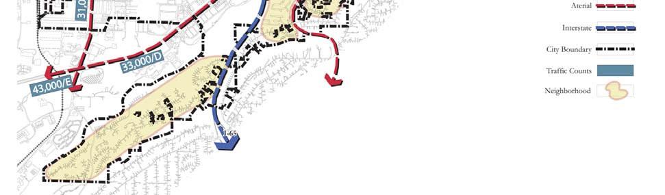
8 Figure 1 Existing Volumes and Roadway Classifications
9 Transportation Plan Homewood, Alabama Roadway Capacity Roadway networks are evaluated by comparing the traffic volumes along each facility to the facility s capacity. Roadway capacity is defined as the ability of the facility to accommodate traffic. Service flow volume is the level of traffic flow (vehicles per day) that can be accommodated at various levels of service. The current level of service scale, as developed by the Transportation Research Board in the Highway Capacity Manual, Sixth Edition, ranges from a level of service "A" to a level of service "F". Abbreviated definitions of each level of service are as follows: Level of Service A Level of Service B Level of Service C Level of Service D Level of Service E Level of Service F Free traffic flow (0% 35% of capacity) Stable traffic flow (35% 50% of capacity) Stable traffic flow (50% 62% of capacity) High-density stable traffic flow (62% 75% of capacity) Capacity level traffic flow (75% 100% of capacity) Forced or breakdown traffic flow (>100% of capacity) As a general rule, the desired operation of a roadway should be no lower than level of service C". Level of service "D" may be acceptable under certain circumstances. A level of service "E" or "F" is considered unacceptable. The methodology used to evaluate roadway segment capacity in this project was a tabular analysis relating roadway classification, number of lanes, levels of service, and daily service volumes. The estimated 24-hour capacities of the facilities included in the area network are shown in Table 1. Figure 1 summarizes the roadway segment levels of service. Skipper Consulting, Inc. 6
10 Transportation Plan Homewood, Alabama TABLE 1 CITY OF HOMEWOOD TRANSPORTATION PLAN ROADWAY CAPACITIES FUNCTIONAL CLASSIFICATION # OF LANES CAPACITIES Freeway 4 68, , , ,000 Expressway 4 50, , ,000 Divided Principal Arterial 2 22, , , ,600 Undivided Principal Arterial 2 17, , , ,100 Divided Minor Arterial 2 21, , ,600 8 N/A Undivided Minor Arterial 2 17, ,400 6 N/A 8 N/A Divided Collector 2 20, , ,000 Undivided Collector 2 16, , ,700 One-way Principal Arterial 2 17, , ,800 One-way Minor Arterial 2 14, , ,000 One-way Collector 2 11, , ,800 One-way Ramp 1 9, , ,000 Skipper Consulting, Inc. 7
11 Transportation Plan Homewood, Alabama LAND USE AND SOCIOECONOMIC DATA The relationship between land use and a transportation system is used to determine the demand for travel on a roadway network. Each land use (residential, commercial, industrial, etc.) generates and attracts traffic depending on the nature of the development and the amount of land developed. In order to identify this demand for travel, inventories of existing land uses must be made. This information is used in conjunction with the physical location of the adjacent land uses, constraints on the roadway network, and other related factors to develop the interrelationship between land use and the transportation system. To catalog the land uses of the study area and to provide a means of quantifying the relationship of land use to transportation demand, the study area was divided into individual cells called traffic analysis zones (TAZ). A traffic analysis zone is defined as a subdivision of a study area of homogeneous land use within a distinct border for the compilation of land use and traffic generation data. A TAZ system developed by the study team was employed for this analysis. A total of 36 zones are included within the City of Homewood. Each traffic analysis zone within the City of Homewood was inventoried to determine existing land uses within its boundary. The existing land use information was used to duplicate current travel demands and trends throughout the City of Homewood. The future travel demands and trends were forecasts based on the land use plan that was developed for the City of Homewood. Other considerations included the density of development in each TAZ and the suitability of vacant land for development in each TAZ. TRANSPORTATION MODELING PROCESS Travel demand models are developed to predict future traffic on the street and highway system. The models are initially developed using existing land use data to duplicate travel for the base year. How well the model duplicates base year conditions is considered as an indication of how well it Skipper Consulting, Inc. 8
12 Transportation Plan Homewood, Alabama will predict future travel. If the model cannot produce traffic volumes similar to those observed on existing streets and highways, then the model is reevaluated and adjustments are made. This adjustment or calibration process continues until the model is adequately simulating base year traffic conditions. The process of building and modifying the model to simulate base year travel is called calibration. After the model is calibrated, trip generation data is developed for the land use plan and input into the model to predict future travel demand. NO BUILD ASSIGNMENT The travel demand generated by the land use plan is assigned to the existing roadway network. The purpose of this step is to identify where future deficiencies might occur if no roadway improvements are undertaken. The future year no-build forecast traffic volumes are illustrated in Figure 2. As was discussed in the Existing Conditions section, the future year no-build forecast traffic volumes were compared with the roadway capacities to determine roadway segment levels of service. Roadways which show a projected volume/capacity (v/c) ratio of greater than 0.75 (Level of Service E ) should be considered deficient. Emphasis should be placed on those areas where the v/c ratio is greater than 1.00 (Level of Service F ). Based on those ratios, the roadways estimated levels of service are also shown in Figure 2. TRANSPORTATION PLAN DEVELOPMENT The Transportation Plan for Homewood, Alabama was developed in an effort to provide a guide for local and state officials to utilize to address existing traffic congestion, mitigate anticipated future year capacity deficiencies, improve mobility, increase safety and promote economic vitality. The Transportation Plan was developed as a result of public meetings, meetings with Homewood officials and the results of analyses that were performed by Skipper Consulting. Various types of roadway improvements have been included in Homewood s Transportation Plan. The improvements include adding travel lanes to existing roadways and constructing new roadways. The Transportation Plan is described below and illustrated in Figure 3. Each improvement is shown in detail in Figures 4 through 11. Skipper Consulting, Inc. 9
13 Figure 2 Future Volumes and Roadway Classifications

14 Figure 3 Transportation Street Plan

15 Figure 4 1. Modify the interchange at I-65 and Lakeshore Drive

16 Figure 5 2. Reconfigure the intersection of Oxmoor Road at West Oxmoor Road


17 Figure 6 3. Develop an access management concept for Green Springs Highway


18 Figure 7 4. Develop an access management concept for Valley Avenue


19 Figure 8 5. Improve the intersection of Valley Avenue and 21 st Street South


20 Figure 9 6. Reconfigure the intersection of Rosedale Drive at 18 th Street South

21 Figure Extend 25 th Court from it s current end to Woodcrest Place

22 Figure Modify the intersection of Hawthorne Drive at Linwood Drive
23 Transportation Plan Homewood, Alabama 1. Modify the interchange at I-65 and Lakeshore Drive. 2. Reconfigure the intersection of Oxmoor Road at West Oxmoor Road. 3. Develop an access management concept for Green Springs Highway 4. Develop an access management concept for Valley Avenue. 5. Improve the intersection of Valley Avenue and 21 st Street South. 6. Reconfigure the intersection of Rosedale Drive at 18 th Street South. 7. Extend 25 th Court from its current end to Woodcrest Place. 8. Modify the intersection of Hawthorne Drive at Linwood Drive. Access Management The success of the Transportation Plan relies on the City s ability to protect current and future capacities of the roadway network. Access management can benefit roadside properties throughout the City of Homewood by promoting safety and improving roadway capacities. If approached properly, access management can enhance property values while safeguarding past and future public investments in the infrastructure. Access management techniques developed for Homewood should incorporate the following strategies to retrofit current roadway corridors and in planning new projects: Separate conflict points distance between major intersections and driveways should be regulated. As a general rule, driveways should not be located within the area of influence of intersections. Restrict turning movements at unsignalized driveways and intersections the use of full directional unsignalized streets and driveways should be limited. Full movement intersections should serve multiple developments through joint use driveways or cross access easements. If frontage roads area available, all driveways should access the frontage roads. Access to the main line should only be permitted at intersections of public roadways. Establish design standards design standards that address access spacing, the length of turn lanes and tapers and driveway dimensions should be developed for application throughout the corridor. Skipper Consulting, Inc. 20
24 Transportation Plan Homewood, Alabama Traffic signal spacing signals should only be installed when appropriate studies indicate their spacing and interconnection can be accomplished without significant impacts on the corridor capacity. Turn lanes left and right turn lanes should be required for all public streets and major access points to adjacent land uses. Shared driveways/inter-parcel access joint use driveways should be required to reduce the proliferation of driveways and to preserve the capacity of the corridor. Pedestrian/bicycle planning specific needs of pedestrian and bicyclist movements should be addressed. Traffic signals should be designed and timed to accommodate pedestrians in those areas of significant activity. Skipper Consulting, Inc. 21
25 Transportation Plan Homewood, Alabama CONCLUSIONS This report summarized the results of a study performed for the transportation system of the City of Homewood. The conditions summarized included traffic analysis for existing, future conditions and recommendations for roadway improvements that would help correct current and future transportation deficiencies. It is virtually impossible to eliminate all transportation deficiencies that may occur in a city but the recommendations in this report will help relieve existing and future traffic congestion, improve mobility, improve traffic safety and increase the opportunity for economic vitality. Skipper Consulting, Inc. 22
City of Wayzata Comprehensive Plan 2030 Transportation Chapter: Appendix A
 A1. Functional Classification Table A-1 illustrates the Metropolitan Council s detailed criteria established for the functional classification of roadways within the Twin Cities Metropolitan Area. Table
Clackamas County Comprehensive Plan
 ROADWAYS The County s road system permits the movement of goods and people between communities and regions, using any of a variety of modes of travel. Roads provide access to virtually all property. They
Chapter 4 Traffic Analysis
 Chapter 4 Traffic Analysis PURPOSE The traffic analysis component of the K-68 Corridor Management Plan incorporates information on the existing transportation network, such as traffic volumes and intersection
Access Management Regulations and Standards
 Access Management Regulations and Standards January 2014 Efficient highway operation Reasonable property access Concept of Access Management The way to manage access to land development while preserving
Recommended Roadway Plan Section 2 - Land Development and Roadway Access
 Recommended Roadway Plan Section 2 - Land Development and Roadway Access SECTION 2 Land Development and Roadway Access 2.1 Land Use and Access Management The Federal Highway Administration (FHWA) defines
5.0 Roadway System Plan
 Southwest Boise Transportation Study Page 16 5.0 Roadway System Plan The Roadway System Plan outlines roadway improvements in the Initial Study Area. It forecasts future deficiencies on the arterial system,
Highway 111 Corridor Study
 Highway 111 Corridor Study June, 2009 LINCOLN CO. HWY 111 CORRIDOR STUDY Draft Study Tea, South Dakota Prepared for City of Tea Sioux Falls Metropolitan Planning Organization Prepared by HDR Engineering,
Subject: Solberg Avenue / I-229 Grade Separation: Traffic Analysis
 MEMORANDUM Transportation Bill Troe, AICP Jason Carbee, AICP 12120 Shamrock Plaza Suite 300 Omaha, NE 68154 (402) 334-8181 (402) 334-1984 (Fax) To: Project File Date: Subject: Solberg Avenue / I-229 Grade
SECTION 1 - TRAFFIC PLANNING
 SECTION 1 - TRAFFIC PLANNING 1.1 TRAFFIC OPERATIONS 1.1.1 Roadway Functional Classification The Multnomah County Comprehensive Framework Plan s Policy 34: Trafficways and the Functional Classification
APPENDIX G: INTERSECTION NEEDS AT OKEECHOBEE BOULEVARD
 APPENDIX G: INTERSECTION NEEDS AT OKEECHOBEE BOULEVARD INTERSECTION NEEDS AT SR 7 and OKEECHOBEE BOULEVARD SR 7 Extension Project Development and Environment (PD&E) Study From Okeechobee Boulevard (SR
Access Management Regulations and Standards for Minor Arterials, Collectors, Local Streets
 Access Management Regulations and Standards for Minor Arterials, Collectors, Local Streets September 2009 Paul Grasewicz Access Management Administrator Concept of Access Management The way to manage access
Access Management Regulations and Standards
 Access Management Regulations and Standards Efficient highway operation Reasonable property access Concept of Access Management The way to manage access to land development while simultaneously preserving
#!! "$% ##! &! # '#! % $ #!
 Executive Summary US Highway 16 (US 16) is the primary corridor connecting Rapid City to the Black Hills region. It serves a growing population of commercial and residential traffic, as well as seasonal
INTRODUCTION THOROUGHFARE SYSTEM CLASSIFICATIONS
 INTRODUCTION The thoroughfare plan will assist public officials in the development of a specialized system for efficient and safe movement of vehicular traffic while minimizing potential conflicts with
Glenn Avenue Corridor Traffic Operational Evaluation
 Glenn Avenue Corridor Traffic Operational Evaluation PREPARED FOR: THE CITY OF AUBURN PREPARED BY: DECEMBER 2007 Glenn Avenue Corridor Study--Auburn, Alabama TABLE OF CONTENTS Introduction... 1 Background
Roadway Classification Design Standards and Policies. Pueblo, Colorado November, 2004
 Roadway Classification Design Standards and Policies Pueblo, Colorado November, 2004 Table of Contents Page Chapter 1. General Provisions 1.1 Jurisdiction 3 1.2 Purpose and Intent 3 1.3 Modification 3
PennDOT Access Management Model Ordinances Training
 PennDOT Access s Training Trainers: Chad Dixson, AICP, TPD Angela Watson, PB Objective of Today Assist Pennsylvania s municipalities and transportation professionals in better understanding the benefits
CITY OF LUCAS 2014 MASTER THOROUGHFARE PLAN
 INTRODUCTION CITY OF LUCAS 2014 MASTER THOROUGHFARE PLAN A thoroughfare system is intended to provide an effective means of moving vehicles within and through a city. The thoroughfare plan will assist
CHAPTER 7 ACCESS MANAGEMENT. Background. Principles of Access Management. Hennepin County Transportation Systems Plan (HC-TSP)
") CHAPTER 7 ACCESS MANAGEMENT Background Principles of Access Management Hennepin County Transportation Systems Plan (HC-TSP) Chapter 7 Access Management 7.1 Background Access management has become an important
CHAPTER 7 ACCESS MANAGEMENT Background Principles of Access Management Hennepin County Transportation Systems Plan (HC-TSP) Chapter 7 Access Management 7.1 Background Access management has become an important
CHAPTER 4: IDENTIFICATION OF ROAD SYSTEM DEFICIENCIES: TRANSPORTATION PLANNING MODEL
 CHAPTER 4: IDENTIFICATION OF ROAD SYSTEM DEFICIENCIES: TRANSPORTATION PLANNING MODEL I. INTRODUCTION Transportation planning models are the primary tools used to predict future travel conditions. With
Route 7 Corridor Study
 Route 7 Corridor Study Executive Summary Study Area The following report analyzes a segment of the Virginia State Route 7 corridor. The corridor study area, spanning over 5 miles in length, is a multi
Chapter 6: Transportation
 Chapter 6: Transportation I. INTRODUCTION The purpose of the Transportation Plan element of the Comprehensive Plan is to provide guidance to the City of North Mankato, as well as existing and future landowners
TRAFFIC IMPACT ANALYSIS
 TRAFFIC IMPACT ANALYSIS FOR THE CHAMPAIGN UNIT#4 SCHOOL DISTRICT PROPOSED HIGH SCHOOL (SPALDING PARK SITE) IN THE CITY OF CHAMPAIGN Final Report Champaign Urbana Urbanized Area Transportation Study 6/24/2014
4. ENVIRONMENTAL IMPACT ANALYSIS 9. TRANSPORTATION AND TRAFFIC
 4. ENVIRONMENTAL IMPACT ANALYSIS 9. TRANSPORTATION AND TRAFFIC 4.9.1 INTRODUCTION The following section addresses the Proposed Project s impact on transportation and traffic based on the Traffic Study
CITY OF SASKATOON COUNCIL POLICY
 ORIGIN/AUTHORITY Clause 1, Report No. 1-1980 and Clause 4, Report No. 22-1990 of the Works and Utilities Committee; Clause 6, Report No. 17-2004 of the Planning and Operations Committee; and Clause D5,
TRAFFIC IMPACT STUDY COMPREHENSIVE UPDATE TOWN OF THOMPSON S STATION, TENNESSEE PREPARED FOR: THE TOWN OF THOMPSON S STATION
 TRAFFIC IMPACT STUDY COMPREHENSIVE UPDATE TOWN OF THOMPSON S STATION, TENNESSEE PREPARED FOR: THE TOWN OF THOMPSON S STATION Transportation Consultants, LLC 1101 17 TH AVENUE SOUTH NASHVILLE, TN 37212
Classification Criteria
 SCHEDULE D TO RECOMMENDED OFFICIAL PLAN AMENDMENT NO. 40 SCHEDULE C-4 Road Criteria Criteria Traffic Service Objective Land Service/Access Typical Daily Traffic Volume Flow characteristics Travel Speed
D.13 Transportation and Traffic
 This section addresses transportation and traffic issues and impacts related to the Proposed Project. Section D.13.1 provides a description of the affected environment for the Proposed Project. Applicable
Los Altos Hills Town Council - June 18, 2015 Palo Alto City Council June 22, AGENDA ITEM #2.B Presentation
 Los Altos Hills Town Council - June 18, 2015 Palo Alto City Council June 22, 2015 AGENDA ITEM #2.B Presentation Previous Presentations Los Altos Hills Town Council in May 2014 and February 2015 Palo Alto
M-58 HIGHWAY ACCESS MANAGEMENT STUDY Mullen Road to Bel-Ray Boulevard. Prepared for CITY OF BELTON. May 2016
 M-58 HIGHWAY ACCESS MANAGEMENT STUDY Prepared for CITY OF BELTON By May 2016 Introduction Missouri State Highway 58 (M-58 Highway) is a major commercial corridor in the City of Belton. As development has
JONESBORO HIGHWAY 63 HIGHWAY 18 CONNECTOR STUDY
 JONESBORO HIGHWAY 63 HIGHWAY 18 CONNECTOR STUDY Craighead County May 2007 JONESBORO HIGHWAY 63 HIGHWAY 18 CONNECTOR STUDY Craighead County May 2007 Prepared by Planning and Research Division Arkansas State
THIS PAGE LEFT BLANK INTENTIONALLY
 GA SR 25 Spur at Canal Road Transportation Impact Analysis PREPARED FOR GLYNN COUNTY, GEORGIA 1725 Reynolds Street, Suite 300 Brunswick, Georgia 31520 PREPARED BY 217 Arrowhead Boulevard Suite 26 Jonesboro,
3.0 ACCESS CONTROL PLAN - HARMONY ROAD (SH68)
") 3.0 ACCESS CONTROL PLAN - HARMONY ROAD (SH68) 3.1 Existing Conditions Roadway Physical Characteristics Typical Section The existing typical cross-section for SH68 is shown on Figure 3-1 and is comprised
3.0 ACCESS CONTROL PLAN - HARMONY ROAD (SH68) 3.1 Existing Conditions Roadway Physical Characteristics Typical Section The existing typical cross-section for SH68 is shown on Figure 3-1 and is comprised
APPENDIXB. Traffic Operations Technical Memorandum
 APPENDIXB Traffic Operations Technical Memorandum Environmental Assessment - Lincoln County, SD 85 th Street: Sundowner Avenue to Louise Avenue November 2017 MEMORANDUM Transportation Jim Kollbaum, PE
Donahue Drive Corridor Traffic Operational Evaluation
 Donahue Drive Corridor Traffic Operational Evaluation PREPARED FOR: THE CITY OF AUBURN PREPARED BY: JANUARY 2007 Donahue Drive Corridor Study--Auburn, Alabama TABLE OF CONTENTS Introduction... 1 Background
3.0 Future Conditions
 3.0 Future Conditions In order to be able to recommend appropriate improvements to the transportation system of the Town, it is important to first understand the nature and volume of traffic that is expected
Access requests to County streets and roadways are processed through one of the following methods:
 13.1 GENERAL APPLICATION PROCESS Access requests to County streets and roadways are processed through one of the following methods: A. Planned Developments may set general locations for access points.
Basalt Creek Transportation Refinement Plan Recommendations
 Basalt Creek Transportation Refinement Plan Recommendations Introduction The Basalt Creek transportation planning effort analyzed future transportation conditions and evaluated alternative strategies for
Policy Number: Effective: 07/11/14 Responsible Division: Planning Date: 07/11/2014 FUNCTIONAL CLASSIFICATION AMENDMENT POLICY
 Policy Number: 2014-025 Effective: 07/11/14 Responsible Division: Planning Date: 07/11/2014 FUNCTIONAL CLASSIFICATION AMENDMENT POLICY POLICY STATEMENT: The Northeast Ohio Areawide Coordinating Agency
City of Elizabeth City Neighborhood Traffic Calming Policy and Guidelines
 City of Elizabeth City Neighborhood Traffic Calming Policy and Guidelines I. Purpose: The City of Elizabeth City is committed to ensure the overall safety and livability of residential neighborhoods. One
Walmart (Store # ) 60 th Street North and Marion Road Sioux Falls, South Dakota
 60 th Street North and Marion Road Sioux Falls, South Dakota") Walmart (Store #4865-00) 60 th Street North and Marion Road Sioux Falls, South Dakota Prepared for: Wal-Mart Stores, Inc. Bentonville, Arkansas Prepared by: Kimley-Horn and Associates, Inc. ã2013 Kimley-Horn
Walmart (Store #4865-00) 60 th Street North and Marion Road Sioux Falls, South Dakota Prepared for: Wal-Mart Stores, Inc. Bentonville, Arkansas Prepared by: Kimley-Horn and Associates, Inc. ã2013 Kimley-Horn
ENHANCED PARKWAY STUDY: PHASE 2 CONTINUOUS FLOW INTERSECTIONS. Final Report
 Preparedby: ENHANCED PARKWAY STUDY: PHASE 2 CONTINUOUS FLOW INTERSECTIONS Final Report Prepared for Maricopa County Department of Transportation Prepared by TABLE OF CONTENTS Page EXECUTIVE SUMMARY ES-1
Access Management Benefits & Techniques. Access Management Workshop June 2, 2006
 Access Management Benefits & Techniques Access Management Workshop June 2, 2006 1 Benefits of Access Management Safety As access density increases, crash rates increase Increasing the density of access
DUNBOW ROAD FUNCTIONAL PLANNING
 DUNBOW ROAD FUNCTIONAL PLANNING Final Report August 3, 216 #31, 316 5th Avenue NE Calgary, AB T2A 6K4 Phone: 43.273.91 Fax: 43.273.344 wattconsultinggroup.com Dunbow Road Functional Planning Final Report
Lee s Summit, Missouri Thoroughfare Master Plan
 Title Text Interstate Reg. 12 pt. Lee s Summit, Missouri Thoroughfare Master Plan April 2006 Lee s Summit, Missouri Thoroughfare Master Plan i Table of Contents Chapter 1 Introduction 1.1 Purpose of the
DRAFT. Corridor study. Honeysuckle Road. October Prepared for the City of Dothan, AL. Prepared by Gresham, Smith and Partners
 DRAFT Corridor study Honeysuckle Road October 2017 Prepared for the City of Dothan, AL Prepared by TABLE OF CONTENTS SECTION I... 1 STUDY SUMMARY... 1 INTRODUCTION... 1 CONCLUSIONS... 5 SECTION II... 7
Traffic Impact Study WestBranch Residential Development Davidson, NC March 2016
 Traffic Impact Study WestBranch Residential Development Davidson, NC March 216 TRAFFIC IMPACT STUDY FOR THE WestBranch Residential Development LOCATED IN DAVIDSON, NC Prepared For: Lennar Carolinas, LLC
METHODOLOGY. Signalized Intersection Average Control Delay (sec/veh)
") Chapter 5 Traffic Analysis 5.1 SUMMARY US /West 6 th Street assumes a unique role in the Lawrence Douglas County transportation system. This principal arterial street currently conveys commuter traffic
Chapter 5 Traffic Analysis 5.1 SUMMARY US /West 6 th Street assumes a unique role in the Lawrence Douglas County transportation system. This principal arterial street currently conveys commuter traffic
Background on the Revisions to VDOT s Access Management Spacing Standards
 December 2011 Background on the Revisions to VDOT s Access Management Spacing Standards Spacing Standards for Commercial Entrances, Signals, Intersections, and Crossovers The spacing standards were located
Transportation Impact Study for Abington Terrace
 Transportation Impact Study for Abington Terrace Abington Township, Montgomery County, PA Sandy A. Koza, P.E., PTOE PA PE License Number PE059911 Prepared by McMahon Associates, Inc. 425 Commerce Drive,
MASTER THOROUGHFARE PLAN
 MASTER THOROUGHFARE PLAN Master Thoroughfare Plan Update November 2015 Prepared for Town of Northlake AVO 30659 11/11/2015 1201 North Bowser Road Richardson, Texas 75081 Firm Registration No. 312 MASTER
Figure 1: East West Connector Alignment Alternatives Concept Drawing
 Page 2 of 9 Figure 1: East West Connector Alignment Alternatives Concept Drawing The Montebello Drive extension will run north south and connect Wilsonville Road to the Boones Ferry Road to Brown Road
TOWN OF CHAPEL HILL POLICY AND PROCEDURES FOR TRAFFIC CALMING MEASURES
 TOWN OF CHAPEL HILL POLICY AND PROCEDURES FOR TRAFFIC CALMING MEASURES (Adopted by the Town Council on June 30, 2004) (Revised December 6, 2010) (Revised February 8, 2016) POLICY AND PROCEDURES FOR TRAFFIC
Overview. Existing Conditions. Corridor Description. Assessment
 Overview A study of the 23 rd Street corridor was undertaken to document the existing conditions, analyze traffic operations, and recommend remedies for deficient situations Although 23 rd Street is frequently
Corridor Studies. LA 415 and LA 73
 Corridor Studies LA 415 and LA 73 Project Approach for Both Corridors 1. Data Collection 2. Data Summary 3. Traffic Analysis 4. Micro-Simulation modeling 5. Generation of alternatives 6. Modeling alternatives
Highway 49, Highway 351 and Highway 91 Improvements Feasibility Study Craighead County
 Highway 49, Highway 351 and Highway 91 Improvements Feasibility Study Craighead County Executive Summary March 2015 Highway 49, Highway 351 and Highway 91 Improvements Feasibility Study Craighead County
WELCOME TO OPEN HOUSE # 1 June 14, 2017
 Langstaff Road Weston Road to Highway 7 Class Environmental Assessment Study WELCOME TO OPEN HOUSE # 1 June 14, 2017 Please sign in and join our mailing list Purpose of Open House #1 & Study Area York
CITY OF COCOA BEACH 2025 COMPREHENSIVE PLAN. Section VIII Mobility Element Goals, Objectives, and Policies
 CITY OF COCOA BEACH 2025 COMPREHENSIVE PLAN Section VIII Mobility Element Goals, Objectives, and Policies Adopted August 6, 2015 by Ordinance No. 1591 VIII MOBILITY ELEMENT Table of Contents Page Number
ADOT Statewide Bicycle and Pedestrian Program Summary of Phase IV Activities APPENDIX B PEDESTRIAN DEMAND INDEX
 ADOT Statewide Bicycle and Pedestrian Program Summary of Activities APPENDIX B PEDESTRIAN DEMAND INDEX May 24, 2009 Pedestrian Demand Index for State Highway Facilities Revised: May 29, 2007 Introduction
Traffic Circulation Study for Neighborhood Southwest of Mockingbird Lane and Airline Road, Highland Park, Texas
 ARIZONA TEXAS NEW MEXICO OKLAHOMA February 13, 2015 Mr. Meran Dadgostar P.E., R.S. Town of Highland Park 4700 Drexel Dr. Highland Park, Texas 75205 Re: Traffic Circulation Study for Neighborhood Southwest
TRANSPORTATION ANALYSIS REPORT US Route 6 Huron, Erie County, Ohio
 TRANSPORTATION ANALYSIS REPORT US Route 6 Huron, Erie County, Ohio December 12, 2012 Prepared for: The City of Huron 417 Main Huron, OH 44839 Providing Practical Experience Technical Excellence and Client
Traffic Impact Analysis Walton Acres at Riverwood Athletic Club Clayton, NC
 Traffic Impact Analysis Walton Acres at Riverwood Athletic Club Clayton, NC 1. TABLE OF CONTENTS INTRODUCTION...1 1.1. Site Location and Study Area...1 1.2. Proposed Land Use and Site Access...2 1.3.
Access Location, Spacing, Turn Lanes, and Medians
 Design Manual Chapter 5 - Roadway Design 5L - Access Management 5L-3 Access Location, Spacing, Turn Lanes, and Medians This section addresses access location, spacing, turn lane and median needs, including
HILLSIDE DISTRICT PLAN White Paper
 HILLSIDE DISTRICT PLAN White Paper ROADWAY CLASSIFICATION July 31, 2007 REPORT CONTENTS Overview p.1 Existing Context & Regulatory Framework p.1 Roadway Classification p.3 Street Typology Additions to
City of Memphis On-Street Parking Modification Guidelines
 City of Memphis Effective Date: December 1, 2013 Bicycle/Pedestrian Program 125 N. Main Street Memphis, TN 38103 (901) 576-6710 www.bikepedmemphis.com City of Memphis Executive Summary It is current practice
SELECTED ROADWAY CAPACITY ANALYSIS
 CHAPTERFOUR SELECTED ROADWAY CAPACITY ANALYSIS 4.1 SELECTED ROADWAY CAPACITY ANALYSIS Introduction Capacity analysis was performed on six selected roadways within the Dearborn County study area using the
Iowa Corridor Management Pilot Project Overview. Recommendations For A Corridor Management Program August 2004
 Iowa Corridor Management Pilot Project Overview Recommendations For A Corridor Management Program August 2004 Presentation Overview Project goals Pilot project selection process Analysis results Segment
Transportation. Introduction
 Transportation 6 Introduction As the City of Johnston continues to grow the demand placed on the transportation network will increase as well. The ability of the network to handle this increased demand
Operational Comparison of Transit Signal Priority Strategies
 Operational Comparison of Transit Signal Priority Strategies Revision Submitted on: November, 0 Author: Adriana Rodriguez, E.I Assistant Engineer Parsons Brinckerhoff 0 South Orange Avenue, Suite 00 Orlando,
CIRCLE DRIVE TRAFFIC AND ACCESS MANAGEMENT POLICY GUIDE. Management Principles and Implementation Concepts
 CIRCLE DRIVE TRAFFIC AND ACCESS MANAGEMENT POLICY GUIDE A. PREFACE Management Principles and Implementation Concepts The intent of this policy guide is to provide interim guidance on the implementation
4 DISRUPTION MANAGEMENT PLAN HIGHWAY 7 RAPIDWAY CONSTRUCTION BETWEEN BAYVIEW AVENUE AND WARDEN AVENUE TOWNS OF MARKHAM AND RICHMOND HILL
 4 DISRUPTION MANAGEMENT PLAN HIGHWAY 7 RAPIDWAY CONSTRUCTION BETWEEN BAYVIEW AVENUE AND WARDEN AVENUE TOWNS OF MARKHAM AND RICHMOND HILL The Transportation Services Committee recommends the adoption of
Traffic Analysis and Design Report. NW Bethany Boulevard. NW Bronson Road to NW West Union Road. Washington County, Oregon
 Traffic Analysis and Design Report NW Bethany Boulevard NW Bronson Road to NW West Union Road Washington County, Oregon May 2011 Table of Contents Table of Contents Section 1 Executive Summary... 2 Section
4.0 ACCESS CONTROL PLAN - SH 14 (JEFFERSON STREET/RIVERSIDE AVENUE)
") 4.1 Existing Conditions Roadway Physical Characteristics Typical Sections Jefferson Street 4.0 ACCESS CONTROL PLAN - SH 14 (JEFFERSON STREET/RIVERSIDE AVENUE) The existing typical cross-section for SH
4.1 Existing Conditions Roadway Physical Characteristics Typical Sections Jefferson Street 4.0 ACCESS CONTROL PLAN - SH 14 (JEFFERSON STREET/RIVERSIDE AVENUE) The existing typical cross-section for SH
Traffic Impact Study. Westlake Elementary School Westlake, Ohio. TMS Engineers, Inc. June 5, 2017
 TMS Engineers, Inc. Traffic Impact Study Westlake Elementary School Westlake, Ohio June 5, 2017 Prepared for: Westlake City Schools - Board of Education 27200 Hilliard Boulevard Westlake, OH 44145 TRAFFIC
Goodlettsville Bicycle and Pedestrian Plan Executive Summary
 Goodlettsville Bicycle and Pedestrian Plan July 2010 In Cooperation with the Nashville Area Metropolitan Planning Executive Organization Summary Introduction Progressive and forward thinking communities
TRAFFIC ASSESSMENT River Edge Colorado
 TRAFFIC ASSESSMENT River Edge Colorado Submitted by: Fehr & Peers 621 17th Street, Ste. 231 Denver, CO 8293 (33) 296-43 December, 21 App. M-2 Traffic Assessment River Edge Colorado December 21 TABLE OF
TRAFFIC AND SAFETY NOTE 608A. Spacing for Commercial Drives and Streets. To Promote a Uniform Practice in Determining Access Spacing
 TRAFFIC AND SAFETY NOTE 608A SUBJECT: PURPOSE: Spacing for Commercial Drives and Streets To Promote a Uniform Practice in Determining Access Spacing COORDINATING UNIT: Geometric Design Unit INFORMATION:
4.11 TRANSPORTATION 4.11 TRANSPORTATION Environmental Setting Intersection, Roadway, and Freeway Evaluation Methodology
 4.11 TRANSPORTATION This section describes the road transportation system in the vicinity of the proposed Project and the potential impacts to this system from the proposed Project. The analysis in this
Chapter 5 FUNCTIONAL CLASSIFICATION
 Chapter 5 FUNCTIONAL CLASSIFICATION Functional classification is a system by which streets and roadways may be distinguished by types according to their function within the entire transportation network.
CITY MANUALS AND STANDARDS REVIEW
 GEORGETOWN SIDEWALK MASTER PLAN CITY MANUALS AND STANDARDS REVIEW RESOURCES AND STANDARDS As part of the Master Plan process, a review and evaluation of current City documents and policies relevant to
ACCESS MANAGEMENT PLAN: BLUFFTON PARKWAY BLUFFTON PARKWAY: PHASE FOUR TOWN OF BLUFFTON & BEAUFORT COUNTY, SC
 ACCESS MANAGEMENT PLAN: BLUFFTON PARKWAY BLUFFTON PARKWAY: PHASE FOUR TOWN OF BLUFFTON & BEAUFORT COUNTY, SC Prepared for: Beaufort County & Town of Bluffton Prepared by: SRS ENGINEERING, LLC 801 Mohawk
List of Attachments. Location Map... Site Plan... City of Lake Elsinore Circulation Element... City of Lake Elsinore Roadway Cross-Sections...
 List of Attachments Exhibits Location Map... Site Plan... City of Lake Elsinore Circulation Element... City of Lake Elsinore Roadway Cross-Sections... Existing Lane Geometry and Traffic Controls... Existing
Mobility and Congestion
 Technical Memorandum Mobility and Congestion Prepared for: Prepared by: September 25, 2013 1 Table of Contents 1. Introduction... 1 2. Congestion Forecasting Process... 1 2.1 Mobility and Congestion Terms...
Appendix C. NORTH METRO STATION AREA TRAFFIC IMPACT STATEMENT 88th Avenue Station
 Appendix C NORTH METRO STATION AREA TRAFFIC IMPACT STATEMENT 88th Avenue Station Prepared for: Regional Transportation Department and URS Corporation as part of the North Metro EIS David Evans and Associates,
MUTCD Part 6G: Type of Temporary Traffic Control Zone Activities
 MUTCD Part 6G: Type of Temporary Traffic Control Zone Activities 6G.01 Typical Applications Each temporary traffic control (TTC) zone is different. Many variables, such as location of work, highway type,
University Hill Transportation Study Technical Memorandum Alternatives Modeling and Analysis May 2007
 Technical Memorandum May 2007 Syracuse Metropolitan Transportation Council Edwards and Kelcey with Wallace Roberts and Todd Alta Planning and Design CONTENTS SECTION ONE- INTRODUCTION...1 SECTION TWO-
NO BUILD TRAFFIC OPERATIONS
 3. 23 NO BUILD TRAFFIC OPERATIONS This section addresses the operations of the transportation system and details how it would be expected to function under year 23 No Build conditions with the projected
Exhibit 1 PLANNING COMMISSION AGENDA ITEM
 Exhibit 1 PLANNING COMMISSION AGENDA ITEM Project Name: Grand Junction Circulation Plan Grand Junction Complete Streets Policy Applicant: City of Grand Junction Representative: David Thornton Address:
Chapter 6 Transportation Plan
 Chapter 6 Transportation Plan Transportation Plan Introduction Chapter 6 Transportation Plan Transportation Plan Introduction This chapter describes the components of Arvada s transportation system, comprised
WYDOT DESIGN GUIDES. Guide for. Non-NHS State Highways
 WYDOT DESIGN GUIDES Guide for Non-NHS State Highways 2014 GUIDE FOR Non-NATIONAL HIGHWAY SYSTEM (Non-NHS) STATE HIGHWAYS PRESERVATION REHABILITATION RECONSTRUCTION INTRODUCTION This Guide is directed to
COWETA HIGH SCHOOL AND EAST HIGHWAY 51
 COWETA HIGH SCHOOL AND EAST HIGHWAY 51 Lack of sidewalks along Ben Lumpkin Rd. Lack of crosswalks and ramps at intersection. Hwy 51 is wide to cross as a pedestrian. No ADA compliance or connection to
EXECUTIVE SUMMARY OF CALEDON TRANSPORTATION NEEDS STUDY
 EXECUTIVE SUMMARY OF CALEDON TRANSPORTATION NEEDS STUDY The Caledon Transportation Needs Study has been undertaken as a joint project by the Town of Caledon and the Region of Peel to determine the existing
1609 E. FRANKLIN STREET HOTEL TRAFFIC IMPACT STUDY EXECUTIVE SUMMARY
 1609 E. FRANKLIN STREET HOTEL TRAFFIC IMPACT STUDY EXECUTIVE SUMMARY Prepared for: The Town of Chapel Hill Public Works Department Traffic Engineering Division Prepared by: HNTB North Carolina, PC 343
TRAFFIC STUDY GUIDELINES Clarksville Street Department
 TRAFFIC STUDY GUIDELINES Clarksville Street Department 9/1/2009 Introduction Traffic studies are used to help the city determine potential impacts to the operation of the surrounding roadway network. Two
Final Sidewalk Feasibility Study
 Garfield Drive From Anastasia Drive to Elizabeth Place City of South Daytona July 23, 2009 Final Sidewalk Feasibility Study Prepared for: Prepared by: Final Sidewalk Feasibility Study Garfield Drive 2
CarMax Auto Superstore/ Reconditioning Center #6002 Murrieta, California
 CarMax Auto Superstore/ Reconditioning Center #6002 Murrieta, California TUSTIN 17782 17th Street Suite 200 Tustin, CA 92780-1947 714.665.4500 Fax: 714.665.4501 LOS ANGELES 145 S. Spring Street Suite 120
T A B L E OF C O N T E N T S
 T A B L E OF C O N T E N T S PART III SUBDIVISION REGULATIONS OF THE DEPARTMENT OF PUBLIC WORKS, C & C D PAGE PAGE Responsibility for Development of Streets......... 29 Right-of-Way Widths...... 37 Purpose...........
City of Gainesville Transportation/Roadway Needs PROJECT SUMMARY
 A1 Roadway Resurfacing $23,846,000 TYPE: Preservation of existing system Roadway resurfacing A2 Signal Replacement $6,000,000 TYPE: Preservation of existing system Replace traffic signals. B1 W 6th St
Frequently Asked Questions
 Frequently Asked Questions Business US 190 in Copperas Cove From Avenue D to Constitution Drive What is access management? A. Access Management is a growing effort by government agencies to improve how
Intersection Traffic Control Feasibility Study
 Intersection Traffic Control Feasibility Study CSAH 9 at CSAH 60 (185th Avenue) Prepared For: Dakota County Transportation Department Western Service Center 14955 Galaxie Avenue, 3rd Floor Apple Valley,