Exposition Corridor Transit Neighborhood Plan
|
|
|
- Vincent Preston
- 5 years ago
- Views:
Transcription
1 Potntial Strtscap Sgmnts ra to Mo d tson l na tio Na B s Ro 5 s lm Pa d V PALMS 7 on gt rin Cla 6 CULVER CITY d A B nic vd Bl n to ng hi as Cu l r nal tio Na d ra to Mo DR Exposition Light Rail Lin 7 l d d ndy S Bu Lgnd br Ga twa y d db y ing S Ro oo tw a Fw nn Cas tl H igh ts s onic Santa Monica Fwy Nationa ll wt Sa am Sant Ma ob Pic ab 1 d ulv Dr 3 in la A SEPULVEDA p 2 y nd BUNDY ESTOOD 3 da an rl Ov pi 4 SS Bu 2 SC nt ym vd wy of S O d ic lymp Ol l cb g Di S an B ll wt Sa M 1 on gt rin ar SB ia ur o iss d o Pic cia Sa Mo tor Mo d tri Pa nta a nic Light Rail Station Station Ara Half-mil Radius Projct Ara Potntial Strtscap Sgmnts N Map not to scal Bundy Dri btwn Pico Boulvard and Missouri Anu Olympic Boulvard btwn Cntinla and Barrington Anus Spulda Boulvard btwn Olympic and National Boulvards Pico Boulvard btwn South Cntinla A & Patrcica Anu Motor Anu btwn Ros A and Palms Boulvard National Boulvard btwn Castl Hights and Motor Anus Palms Boulvard btwn Motor Anu and National Boulvard This projct is partially fundd by Mtro


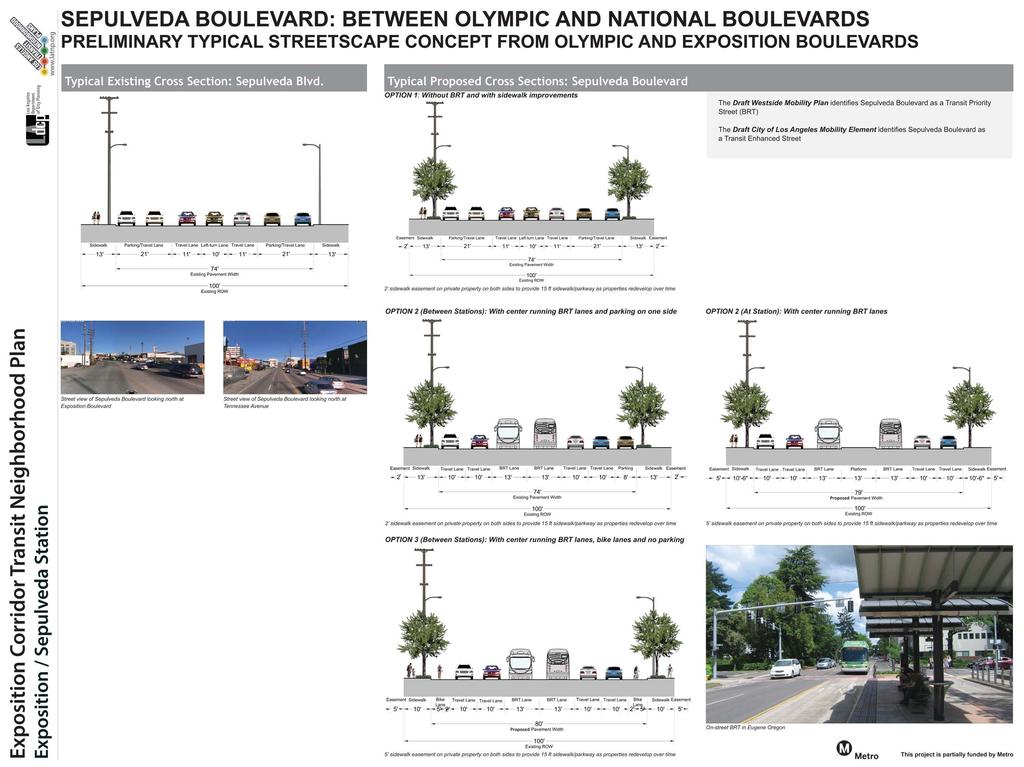
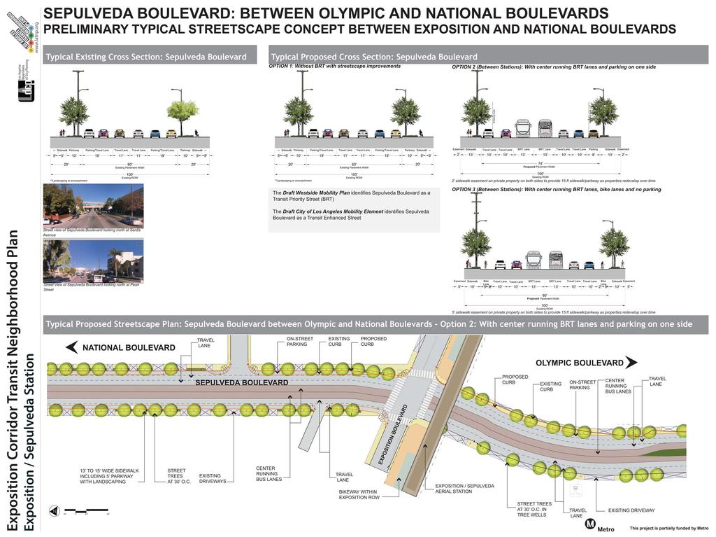
2 wwwlatnporg OLYMPIC BOULEVARD: CENTINELA TO BARRINGTON AVENUES PRELIMINARY TYPICAL STREETSCAPE CONCEPT Typical Existing Cross Sction: Olympic Boulvard Typical Proposd Cross Sction: Olympic Boulvard Strt viw of Olympic Boulvard looking ast from Cntinla Anu 3 sidwalk asmnt on privat proprty to provid 15 ft sidwalk/parkway as proprtis rdlop or tim Exposition / Bundy Station Strt viw of Olympic Boulvard looking ast nar Bundy Dri Typical Proposd Strtscap Plan: Olympic Boulvard CENTINELA AVENUE 5 x 8 TREE ELLS LANDSCAPED MEDIAN IN BETEEN LEFT-TURN POCKETS 4 OLYMPIC BLVD AT 3 OC DRIVEAY IN TREE ELLS AT 3 OC AND PARKING AND PARKING TRAVEL IN TREE ELLS AT 3 OC 5 x 8 TREE ELLS BARRINGTON AVENUE This projct is partially fundd by Mtro


3 wwwlatnporg BUNDY DRIVE: BETEEN PICO BOULEVARD AND MISSOURI AVENUE PRELIMINARY TYPICAL STREETSCAPE CONCEPT BETEEN OLYMPIC BOULEVARD AND MISSOURI AVENUE Typical Existing Cross Sction: Bundy Dri Typical Proposd Cross Sction: Bundy Dri - idns sidwalks and adds trs within xisting RO OPTION 1: Rtains parking and no bik lans OPTION 2: ith bik lans and no parking 5 sidwalk asmnt on privat proprtis to provid 15ft sidwalk/parkway, as proprtis rdlop or tim 5 sidwalk asmnt on privat proprtis to provid 15ft sidwalk/parkway, as proprtis rdlop or tim Exposition / Bundy Station Strt viw of Bundy Dri looking south at Missouri Anu Strt viw of Bundy Dri looking south at La Grang Anu Typical Proposd Strtscap Plan: Bundy Dri - Option 2: ith Bik Lans and No Parking OLYMPIC BOULEVARD SSISSIPPI AVENUE BIKE MERGES ITH AT 3 OC IN TREE ELLS TO-AY LEFT TURN BUNDY DRIVE 5 X 8 TREE ELLS AT 3 OC IN TREE ELLS BUFFERED BIKE 13 TO 15 IDE SIDEALK ITH IN TREE ELLS 13 TO 15 IDE SIDEALK ITH IN TREE ELLS BUFFERED BIKE LA GRANGE AVENUE DRIVEAY MISSOURI AVENUE CROSSALK This projct is partially fundd by Mtro 4


4 wwwlatnporg BUNDY DRIVE: BETEEN PICO BOULEVARD AND MISSOURI AVENUE PRELIMINARY TYPICAL STREETSCAPE CONCEPT BETEEN PICO AND OLYMPIC BOULEVARDS Typical Existing Cross Sction: Bundy Dri Typical Proposd Cross Sction: Bundy Dri - idns sidwalks and adds trs within xisting RO OPTION 1: Rtains parking on on sid and no bik lans OPTION 2: ith bik lans and no parking Parking 8 Tral Lan 11 **3 sidwalk asmnt on privat proprtis to provid 15ft sidwalk/parkway, as proprtis rdlop or tim **3 sidwalk asmnt on privat proprtis to provid 15ft sidwalk/parkway, as proprtis rdlop ortim Exposition / Bundy Station Strt viw of Bundy Dri looking north of Tnnss Anu Typical Proposd Strtscap Plan: Bundy Dri - Option 1: Rtains parking on on sid and no bik lans DRIVEAY AT 3 OC PICO BOULEVARD 4 Strt viw of Bundy Dri looking north at Exposition Boulvard TRAVEL TENNESSEE AVE TENNESSEE AVENUE 13 TO 15 IDE SIDEALK INCLUDING 5 PARKAY ITH LANDSCAPING 1 13 TO 15 IDE SIDEALK INCLUDING 5 PARKAY ITH LANDSCAPING BUNDY DRIVE TRAVEL ELIMINATE ON-STREERT PARKING ON PARKING ONE SIDE ELIMINATE PARKING ON-STREET ON ONE SIDE PARKING EXPOSITION BOULEVARD 5 IDE PARKAY PLANTER ITH BUFFER LANDSCAPING BIKEAY ITHIN EXPOSITION RO EXPO/BUNDY AERIAL STATION AT 3 OC OLYMPIC BOULEVARD CROSSALKS MISSOURI AVENUE MISSISSIPPI AVENUE This projct is partially fundd by Mtro
5
6


7 wwwlatnporg NATIONAL BOULEVARD: BETEEN CASTLE HEIGHTS AND MOTOR AVENUES PRELIMINARY TYPICAL STREETSCAPE CONCEPT Typical Existing Cross Sctions: National Boulvard Existing Typical Cross Sction: Motor Anu to Palms/Exposition Boulvard Typical Proposd Cross Sction: National Boulvard Proposd Typical Cross Sction: Motor Anu to Palms/Exposition Boulvard - Bik Lans and no parking on on sid Existing Typical Cross Sction: National Boulvard looking ast at Jasmin Anu Existing Typical Cross Sction: Palms/Exposition Boulvard to Castl Hights Anu Proposd Typical Cross Sction: Palms/Exposition Boulvard to Castl Hights Anu - Strtscap impromnts Exposition / Palms Station Existing Typical Cross Sction: National Boulvard looking ast at Barbydll Dri Typical Proposd Strtscap Plan: National Boulvard btwn Motor Anu to Palms/Exposition Boulvard - Bik Lans and No Parking on On Sid CROSSALKS MOTOR AVE 12 IDE SIDEALK ITH IN TREE ELLS DRIVEAY ON-STREET PARKING 15 IDE SIDEALK INCLUDING 5 PARKAY ITH LANDSCAPING BUFFERED BIKE NATIONAL BLVD BUFFERED BIKE 5 to 7 sidwalk asmnt on privat proprty to provid 12ft to15 ft sidwalk/parkway as proprtis rdlop or tim AT 3 OC IN 5 X 8 TREE ELLS VINTON AVE S AT 3 OC IN LANDSCAPED PARKAY PALMS BOULEVARD 4 This projct is partially fundd by Mtro


8 wwwlatnporg PALMS BOULEVARD: BETEEN MOTOR AVENUE AND NATIONAL BOULEVARD PRELIMINARY TYPICAL STREETSCAPE CONCEPT Typical Existing Cross Sction: Palms Boulvard Typical Proposd Cross Sction: Palms Boulvard - Curb Extnsions in btwn Parking Stalls Exposition / Palms Station Narrow sidwalks with numrous curb-cuts/driways Limitd crosswalks points mak th pdstrian nvironmnt mor challnging and unsaf Typical Proposd Strtscap Plan: Palms Boulvard - Curb Extnsions in btwn Parking Stalls MOTOR AVENUE BUS ZONE JASMINE AVENUE CROSSALK BUS ZONE 5 sidwalk asmnt on privat proprty to provid 12 ft sidwalk/parkway as proprtis rdlop or tim LANDSCAPED EXTENSIONS BETEEN ON-STREET PARKING STALLS TO PROVIDE BUFFER AND SHADE PALMS BOULEVARD ON-STREET PARKING STREET TREES DRIVEAY ON-STREET PARKING Exampls of landscapd curb xtnsions in btwn parking stalls Ths landscap curb xtnsions provid buffr and shad for pdstrians and rplac th asphalt with bds plantd in nati spcis CLARINGTON AVENUE CROSSALKS NATIONAL BOULEVARD 4 This projct is partially fundd by Mtro
PRELIMINARY ROAD DESIGN
 SCAL: VR X SPAC (. ha) County of ssex.m RSRV TO OTCT ACCSS.m RSRV TO OTCT ACCSS TO.C. ROW SPAC (. ha) POTNTIAL MBANKMNT. ha POTNTIAL MBANKMNT Town of Tecumseh CANADIAN PACIFIC RAILWAY. ha LIMIT OF STUDY
EXPO II BIKE PATH - NORTHVALE GAP CLOSURE
 Project Overview and Context Beverly Hills UCLA Los Angeles Project Area Santa Monica USC Culver City Source: StreetsblogLA Expo Bike Path (outside of Project Area) Vicinity Map stub of Expo Bike Path
CITY OF DELRAY BEACH. Overview Map. Commuter Mode of Choice QUICK FACTS. 47 Median Age. 65,804 Residents. 29.1% Traditionally Underserved
 CITY OF $51,829 Median Income 291% Traditionally Underserved 438% Growth from 2010 859% HS/GED 345% Bachelors 27,041 Households 620% Labor Force Lake Okeechobee Delray Beach Palm Beach County Commuter
Lawrence Avenue Streetscape Concepts August 30, 2011
 Lawrence Avenue Streetscape Concepts August 30, 2011 Neighborhood Context Phase II: River to Western Ave. Phase I: Western Ave. to Clark St. Key Map Lawrence Ave. Existing Streetscape Conditions East of
Ocean Park Boulevard Green Street Project Community Workshop
 Ocean Park Boulevard Green Street Project Community Workshop 2.2.10 Project Objectives Community Priority: reclaim OPB for public open space. Build upon LUCE principles; neighborhood enhancement, connectivity,
Ocean Park Boulevard Streetscape Improvement Project Alternatives & Trade Offs
 City Council Study Session January 27, 2009 Ocean Park Boulevard Streetscape Improvement Project Alternatives & Trade Offs Scope of Work Purpose of Tonight s Meeting Review work to date and direct staff
Ocean Park Boulevard Green Street Project Alternatives & Trade Offs
 Planning Commission March 4, 2009 Ocean Park Boulevard Green Street Project Alternatives & Trade Offs Purpose of Tonight s Meeting Review concept plans and options Provide input on alternatives and trade-offs
PEDESTRIAN ACTION PLAN
 CITY OF SANTA MONICA PEDESTRIAN ACTION PLAN DRAFT OCTOBER 2015 Safe Streets Santa Monica, December 3, 2015 Beth Rolandson, AICP Principal Transportation Planner Strategic + Transportation Planning, Planning
Good Neighbor Plan Initiative Update. Transportation & Trinity River Project Committee 9 September 2013 Dallas Love Field Phase One Final Report
 Good Neighbor Plan Initiative Update Transportation & Trinity River Project Committee 9 September 213 Dallas Love Field Phase One Final Report PURPOSE As briefed to the Transportation and Environmental
Rail Station Fact Sheet North Richland Hills Smithfield Station* (*station under construction with anticipated start of service in late 2018)
") ail tation Fact heet North ichland Hills mithfield tation* (*station under construction with anticipated start of service in late 018) tation Overview North ichland Hills mithfield tation will be located
ail tation Fact heet North ichland Hills mithfield tation* (*station under construction with anticipated start of service in late 018) tation Overview North ichland Hills mithfield tation will be located
474 NORTH RODEO DRIVE
 BEVERLY HILLS CA 474 NORTH RODEO DRIVE HORIZONTAL IMAGE 9495 SOUTH SANTA MONICA BOULEVARD SPACE DETAILS LOCATION Northeast corner of South Santa Monica Boulevard and North Rodeo Drive SPACE 1,450 SF 1,400
Rail Station Fact Sheet North Side Station* (*station under construction with anticipated start of service in late 2018)
") Rail Station Fact Sheet North Side Station* (*station under construction with anticipated start of service in late 018) Station Overview North Side Station will be located near the intersection of North
Rail Station Fact Sheet North Side Station* (*station under construction with anticipated start of service in late 018) Station Overview North Side Station will be located near the intersection of North
Community Meeting February 27, 2007 Dorchester Avenue Transportation & Streetscape Improvements Action Plan February 27, 2007
 Community Meeting Tonight s Agenda 6:00 Introductions South Boston/Dot Ave Improvement Study Background 6:15 Consultant Introductions Review of Scope and Schedule Review of Proposed Corridor Wide Guidelines
City of Los Angeles CALIFORNIA
 DEPARTMENT OF CITY PLANNING 00 N. SPRING STREET, ROOM 55 LOS ANGELES, CA 9001-4801 AND 66 VAN NUYS BLVD., SUITE 351 VAN NUYS, CA 91401 C CITY PLANNING COMMISSION WILLIAM ROSCHEN PRESIDENT REGINA M. FREER
City of Los Angeles CALIFORNIA
 DEPARTMENT OF CITY PLANNING 200 N. SPRING STREET, ROOM 2 LOS ANGELES, CA 90012-4801 AND 6262 VAN NUYS BLVD., SUITE 31 VAN NUYS, CA 91401 - CITY PLANNING COMMISSION WILLIAM ROSCHEN PRESIDENT REGINA M. FREER
ACTION: SELECT PREFERRED LIGHT RAIL ALIGNMENT FOR PHASE 2 OF THE EXPOSITION CORRIDOR TRANSIT PROJECT
 6.h DATE: APRIL 2, 2009 TO: FROM: BOARD OF DIRECTORS RICHARD D. THORPE CHIEF EXECUTIVE OFFICER ACTION: SELECT PREFERRED LIGHT RAIL ALIGNMENT FOR PHASE 2 OF THE EXPOSITION CORRIDOR TRANSIT PROJECT RECOMMENDATION
PUBLIC REALM MASTER PLAN
 WESTSHORE BUSINESS DISTRICT PUBLIC REALM MASTER PLAN MASTER PLAN COMMITTEE MEETING MARCH 20, 2013 WESTSHORE BUSINESS DISTRCT PUBLIC REALM MASTER PLAN MACRO-SCALE CONCEPT: A PUBLIC REALM FRAMEWORK DEFINED
PEDESTRIAN ACTION PLAN
 CITY OF SANTA MONICA PEDESTRIAN ACTION PLAN DRAFT OCTOBER 2015 City Council, February 23, 2016 Beth Rolandson, AICP Principal Transportation Planner Mobility Division, Planning and Community Development
Scoping Meeting: April 10, 2013 / Comment Period: March 14, 2013 to April 15, 2013
 GENERAL COMMENTS Upload information boards to LATNP website Insufficient time between the scoping meeting and the deadline for the comments. Do station-by-station analysis in DEIR, not an overall corridor
7/23/2017 VIA . Michael Hanebutt City of Sacramento Community Development Department 300 Richards Boulevard, 3 rd Floor Sacramento, CA 95811
 7/23/2017 VIA EMAIL Michael Hanebutt City of Sacramento Community Development Department 300 Richards Boulevard, 3 rd Floor Sacramento, CA 95811 RE: 65 th Street Apartments (DR17-220) Dear Mr. Hanebutt:
City of El Cerrito San Pablo Avenue Specific Plan. Capital Improvement Program
 City of El Cerrito San Pablo Avenue Specific Plan Capital Improvement Program May 2015 San Pablo Avenue Intersection Improvements San Pablo Avenue and Hill Street/Eastshore Boulevard Background Existing
Mission-Geneva Transportation Study Community Workshop 2 July 8, 2006
 Community Workshop 2 July 8, 2006 Small Group Workbook 1 Basic Improvements on Mission Street Streetscape. Pedestrian-scale lighting; landscaping; community art on utility boxes; more (possibly unique)
Safe Routes to School: Valverde Elementary Walk Audit Report. Image: CPLIVE, SkyscraperPage.com
 Safe Routes to School: Valverde Elementary Walk Audit Report Image: CPLIVE, SkyscraperPage.com April 28, 2016 1 OVERVIEW As part of the 2014/2015 Denver Safe Routes to School (SRTS) Program, WalkDenver
Appendix I Street Cross-Sections
 Appendix I Street Cro-Section Undertanding Rolyn Street Cro-Section Tenty-five treet cro-ection ere created for the Rolyn Multimodal Tranportation Study. In ome cae, alternative cro-ection have been prepared
Improving Bicycle/Pedestrian Access at Select Rail Stations
 Improving Bicycle/Pedestrian Access at Select Rail Stations Wheaton Station, Montgomery County This document is part of a Transportation Planning Board project focused on identifying and documenting specific,
Chapter 3 BUS IMPROVEMENT CONCEPTS
 Chapter 3 BUS IMPROVEMENT CONCEPTS The purpose of this chapter is to describe potential bus improvement strategies and potential impacts or implications associated with BRT implementation within the existing
83 AVENUE PRE-CONSTRUCTION MEETING
 83 AVENUE PRE-CONSTRUCTION MEETING April 6, 2017 5-8PM Please visit displays for project information Talk to staff, ask questions, visit website at: www.edmonton.ca/bike83avenue Pre-Construction Meeting
CONTACT US. NOW LEASING Crossings at El Dorado NEW SHOPPING CENTER DEVELOPMENT PADS AVAILABLE. Phase II. Phase III
 11 4 10 33 23 7 Jan. Mn L Suit A 2,900 s.f. Suit B 2,700 s.f. NEW SHOPPING CENTER DEVELOPMENT PADS AVAILABLE 5 k H a i n g t o n at El Dorao 0 60' 200' 20 k 115 stalls 100 ALLS P-2 PAD BLDG'S ALLS Driv
Presentation Outline. Project/Study Purpose. Existing Conditions. Future Conditions. Understanding the Streetside. Similar Walkable Environments
 Presentation Outline Project/Study Purpose Study Area Map Existing Conditions Future Conditions Understanding the Streetside Similar Walkable Environments Conceptual Alternatives Magnolia/NE 1st Ave Block
FOCUS AREA 1 - Alberta Avenue Pocket Park 3 (121 Ave and 92 St)
") FOCUS AREA 1 - Alberta Avenue Pocket Park 3 (121 Ave and 92 St) New benches Plant evergreen trees Widen existing sidewalk from 1.5m to 1.8m Marked crosswalk 1.8m wide sidewalk Add pedestrian oriented lights
FOCUS AREA 1 - Alberta Avenue Pocket Park 3 (121 Ave and 92 St) New benches Plant evergreen trees Widen existing sidewalk from 1.5m to 1.8m Marked crosswalk 1.8m wide sidewalk Add pedestrian oriented lights
City of Sammamish. Welcome. Issaquah-Fall City Road Improvements Project Phase I Design: 242nd Avenue SE to Klahanie Drive SE
 Welcome Welcome to the third community meeting for the Issaquah-Fall City Road Improvements Project. AGENDA 6:00 p.m. Welcome and sign-in 6:10 p.m. Presentation 6:50 p.m. Open house Learn about the roadway
TRANSPORTATION IMPACT STUDY HYATT PLACE HOTEL EXPANSION AND OLD DAVIS ROAD EXTENSION
 TRANSPORTATION IMPACT STUDY HYATT PLACE HOTEL EXPANSION AND OLD DAVIS ROAD EXTENSION Prpard for: Submittd by: 2990 Lava Ridg Ct. Suit 200 Rosvill, CA. 95661 TABLE OF CONTENTS 1. Introduction... 1 Projct
Fulton Market Streetscape
 Fulton Market Streetscape Ogden Avenue to Halsted Street Public Meeting Recommended Improvements December 10th, 2014 Meeting Purpose and Goals Present Existing Conditions Community Input and Charrette
Brooklyn Boulevard (County Road 152) Reconstruction Project Phase I. OPEN HOUSE June 20, 2017
 Reconstruction Project Phase I. OPEN HOUSE June 20, 2017") Brooklyn Boulevard (County Road 152) Reconstruction Project Phase I OPEN HOUSE June 20, 2017 Brooklyn Boulevard (County Road 152) Phase I Project Partners Project Lead Other Project Partners include Brooklyn
Brooklyn Boulevard (County Road 152) Reconstruction Project Phase I OPEN HOUSE June 20, 2017 Brooklyn Boulevard (County Road 152) Phase I Project Partners Project Lead Other Project Partners include Brooklyn
Dra Design and Land Use Op ons Booklet
 Dra Design and Land Use Op ons Booklet March, 2015 This page was inten onally le blank. 2 Commercial-Vista Corridor Plan This booklet summarizes the street design and land use alterna ves for the Commercial
NJDOT Complete Streets Checklist
 Background The New Jersey Department of Transportation s Complete Streets Policy promotes a comprehensive, integrated, connected multi-modal network by providing connections to bicycling and walking trip
STREETSCAPE CONCEPTS
 STREETSCAPE S CARGO WAY CARGO WAY CYCLE TRACK Streetscape Concepts JENNINGS ST Illustrative Plan EVANS AVE PG&E BAY TRAIL HERON S HEAD PARK The recommended improvements build off the planned improvements
STATE OF MICHIGAN DEPARTMENT OF NATURAL RESOURCES LANSING. 16 April 2013
 STATE OF MICHIGAN DEPARTMENT OF NATURAL RESOURCES LANSING DNR DEPARTMENT OF NATURAL RESOURCES MICHIG AN April 0 Allegan County Board of Commissioners Chestnut Street Allegan, MI 4900 Dear Allegan County
Safe Routes to School: Munroe Elementary Walk Audit Report. Image: Drexel, Barrell & Co.
 Safe Routes to School: Munroe Elementary Walk Audit Report Image: Drexel, Barrell & Co. April 12, 2016 OVERVIEW As part of the 2014/2015 Denver Safe Routes to School (SRTS) Program, WalkDenver coordinated
including shade trees; Recommend minimum 13 ft total sidewalk
 Appendix B Projects From Other Plans Location Type of Project Description West. Julian St. Intersection and streetscape along West Julian St. Intersection and scape : Add high visibility side street crosswalks
If a person walks within this focus area, these are examples of the places he or she could walk to or from:
 Portland Hillsdale Hillsdale Portland The Hillsdale focus area is located in the City of Portland. It is situated approximately three miles from the City of Portland s downtown, 5.5 miles from the City
North Avenue Corridor Study
 North Avenue Corridor Study Advisory Committee Meeting #6 July 1, 2014 Agenda Concept Revisions based on Advisory Committee feedback Review of New Concept Scoring & Costs Concept Discussion/Questions Voting:
TRANSPORTATION COMMISSION Agenda Staff Report
 TRANSPORTATION COMMISSION Agenda Staff Report Agenda Item No. 5.a DATE: JULY 31, 2014 TO: FROM: SUBJECT: TRANSPORTATION COMMISSION COMMUNITY DEVELOPMENT DEPARTMENT - PLANNING DRAFT OLYMPIC CORRIDOR PREFERRED
PROJECT KEY TYPICAL SECTION 1 =60
 6 WASHINGTON BLVD - BETWEEN NE 1ST ST AND NE 3RD ST Washington Boulevard is a low volume, low speed one-way road, signed for no street between NE 1st Street and NE 2nd Street, and closed to traffic between
ALT E R N AT I VE 1 C O R R I DO R - SHEET 2
 xxvii Appendix C Pond Sree Revializaion Bus dolupa rae exceprovid u la apiduci officiandae ommo eium quae dolupain odi re corae si re, simusamus au dis au quian ven in conserae. Ima sediaem quam verem.
12/4/2016 VIA . RE: Grocery Outlet Del Paso (DR16-328)
") 12/4/2016 VIA EMAIL Ethan Meltzer, Assistant Planner City of Sacramento Community Development Department 300 Richards Blvd, 3 rd Floor Sacramento, CA 95811 RE: Grocery Outlet Del Paso (DR16-328) Dear Mr.
12/4/2016 VIA EMAIL Ethan Meltzer, Assistant Planner City of Sacramento Community Development Department 300 Richards Blvd, 3 rd Floor Sacramento, CA 95811 RE: Grocery Outlet Del Paso (DR16-328) Dear Mr.
Rail Station Fact Sheet CityLine/Bush Station
 Rail Station Fact Sheet CityLine/Bush Station Station Overview CityLine/Bush Station is located just south of the President George Bush Turnpike and east of US 75 in Richardson. The station opened in 00
Premium Report 27/07/2017
 TABL O COTT Images...1 Length Diagram...4 Pitch Diagram...5 Area Diagram...6 otes Diagram...7 Penetrations Diagram...8 Report ummary...9 MAURMT In this 3D model, facets appear as semi-transparent to reveal
Pre-Construction Meeting
 Pre-Construction Meeting Wednesday, March 21 Drop-in from 5 9pm Please visit displays for project information, talk to staff, and ask questions! Edmonton.ca/SouthsideBikeRoutes Objectives & Project Scope
El Camino Real Specific Plan. TAC/CAC Meeting #2 Aug 1, 2018
 El Camino Real Specific Plan TAC/CAC Meeting #2 Aug 1, 2018 Land Use Alternatives Goals and Tradeoffs Parks & open space Housing Retail & services Civic spaces Parking Community gathering spaces 3 Alternatives
Meade Street Bridge Design Alternative Study
 Meade Street Bridge Design Alternative Study Preferred Alternative Presentation Stakeholder Meeting #3 June 23, 2011 Presented by: Dan Biggs, RLA Meeting Agenda Purpose: 1. Review Meeting #2 Feedback 2.
City of Seattle Edward B. Murray, Mayor
 City of Seattle Edward B. Murray, Mayor Department of Transportation Scott Kubly, Director Eastlake Community Council 117 E Louisa St. #1 Seattle, WA 98102-3278 January 28, 2016 RE: Roosevelt to Downtown
WELCOME! Please complete a comment sheet as we value your feedback. 4 pm to 8 pm. September 15, Hosted by: AECOM on behalf of City of Calgary
 WELCOME! Thank you for attending our open house. There will be no formal presentation today so please take the time to read the boards. If you have any questions, please do not hesitate to approach one
This page intentionally left blank.
 This page intentionally left blank. Community Plan Catoosa Community Overview Catoosa Catoosa is a city of just over 7,000 residents adjacent to the northeast border of Tulsa. The city contains two major
New York City School Safety Engineering Program. Jackson Wandres The RBA Group June 09, 2005
 8,008,271 858,661 New York City School Safety Engineering Program Jackson Wandres The RBA Group June 09, 2005 Office of School Safety Engineering Project Goals 1) Improve traffic and pedestrian safety.
Community Workshop Pedestrian and Bicycle Mobility Plan Update
 Community Workshop Pdstrian and Bicycl Mobility Plan Updat JUNE 15, 2013 9:00AM - 11:30AM WEST HOLLYWOOD LIBRARY PG. a Wlcom Opning Rmarks - Mayor Land Prsntation (9:20 AM - 10:00 AM) Introduction to th
5 CIRCULATION AND STREET DESIGN
 5 CIRCULATION AND STREET DESIGN This chapter describes circulation and streetscape improvements proposed for the Northwest Chico Specific Plan Area. It includes detailed design specifications for existing
shared-use paths dedicated places for people on foot and on bicycles, separated from vehicles
 G BLB G shared-use paths dedicated places for people on foot and on bicycles, separated from vehicles Figure 1003.1 SHRD-US PTHS are designed for many types of users- recreational cyclists moving at 10+
ROUTE 81 CORRIDOR STUDY DESIGN CONCEPTS
 RT 81 Corridor Study CLINTON ROUTE 81 CORRIDOR STUDY DESIGN CONCEPTS View north on High Street, with potential improvements to the streetscape Draft Recommendations November 8 th, 2018 TOWN OF CLINTON
Merrick and Memorial Neighborhood Study 5/14/2014 Public Meeting
 Merrick and Memorial Neighborhood Study 5/14/2014 Public Meeting Study Area April 9 Public Meeting Comments Summary Pedestrian Safety - A Walking Neighborhood Pedestrian traffic is very difficult A need
Operations -- Transit From: N/A To: N/A. Improvement Type: Regionally Significant: No
 Central Puget Sound Regional 2017-2020 Transportation Improvement Program Amendments and Corrections to be included in the 2017-20 STIP PSRC's Amendment 2017-08 County: King List of 17-08 Amendment Projects:
Agenda. Overview PRINCE GEORGE S PLAZA METRO AREA PEDESTRIAN PLAN
 PRINCE GEORGE S PLAZA METRO AREA PEDESTRIAN PLAN May 28, 2008 Agenda Welcome and introductions Project overview and issue identification Planning context and strengths Design challenges and initial recommendations
Item to be Addressed Checklist Consideration YES NO N/A Required Description Complete Streets Guidelines
 Passaic County Complete Streets Checklist - Concept Development Project Name Item to be Addressed Checklist Consideration YES NO N/A Required Description Complete Streets Guidelines Existing Plans Have
Citizen Advisory Group Meeting #8 May 5, Welcome. Today s meeting will focus on: Land Use & Transportation CHARLOTTEPLANNING.
 Citizen Advisory Group Meeting #8 May 5, 2010 Welcome. Today s meeting will focus on: Land Use & Transportation CHARLOTTEPLANNING.ORG Meeting Agenda Handouts: o Meeting Agenda o Summary of East Seventh
Rail Station Fact Sheet Downtown Carrollton Station
 Rail Station Fact Sheet Downtown Carrollton Station Station Overview Downtown Carrollton Station is located at East Belt Line Road and Broadway Street near the historic Downtown Carrollton Square. The
Duwamish Way-finding and CTR Report
 V. North Tukwila When the North Tukwila Manufacturing and Industrial Center was designated in 1992 as part of the region s land use and transportation plan, the plan called for the area to set a light-rail
Option W: N. Washington Street Project
 Option W: N. Washington Street Project Location: one block of North Washington Street, between West Broad Street and Park Avenue Description: upgrades to existing lighting new brick sidewalk to replace
Downtown Naples Mobility and Connectivity Study. Naples City Council Presentation January 2017
 Downtown Naples Mobility and Connectivity Study Naples City Council Presentation January 2017 Agenda 1. Introduction 2. Scope Review 3. Project Schedule 4. Existing Conditions 5. Public Charrette 6. Mobility
IV. ENVIRONMENTAL IMPACT ANALYSIS K. TRAFFIC AND TRANSPORTATION
 IV. ENVIRONMENTAL IMPACT ANALYSIS K. TRAFFIC AND TRANSPORTATION The information in this section is based primarily on the Traffic Impact Analysis Report prepared by Hirsch/Green Transportation Consulting,
TRANSPORTATION STANDARDS
 INTRODUCTION LOCAL STREETS ON-STREET PARKING SIDEWALKS STREET LIGHTING STREET FURNISHINGS TRAFFIC CALMING STREET TREES MEDIAN PLANTING BOULEVARD LOCATIONS VILLAGE CENTER STREET LOCATIONS RESIDENTIAL STREET
3/10/2016 VIA th Street, Suite 203 Sacramento, CA
 3/10/2016 VIA EMAIL Arwen Wacht, Associate Planner City of Sacramento Community Development Department 300 Richards Boulevard, 3 rd Floor Sacramento, CA 95811 RE: Natomas Fountains (P16-012) Dear Ms. Wacht:
25th Avenue Road Diet Project A One Year Evaluation. Transportation Fund for Clean Air Project #05R07
 25th Avenue Road Diet Project A One Year Evaluation Transportation Fund for Clean Air Project #05R07 Submitted by: The San Francisco Municipal Transportation Agency Dan Provence May 22, 2009 EXECUTIVE
SANTA CRUZ/ALAMEDA ROAD CONFIGURATIONS INTERSECTION AND STREET VIEWS
 SANTA CRUZ/ALAMEDA ROAD CONFIGURATIONS INTERSECTION AND STREET VIEWS This presentation includes the documentation found in Safety Issues Report sections: 1, 7, 8, 9, 10, 11, 12, and18 The 3 sections of
MASONIC AVENUE STREET DESIGN STUDY Community Workshop 2. Masonic Ave Street Design Study Community Workshop 2 August 10, 2010
 Masonic Ave Street Design Study Community Workshop 2 August 10, 2010 Introduction MASONIC AVENUE STREET DESIGN STUDY Community Workshop 2 SF Municipal Transportation Agency Javad Mirabdal, Project Manager
Appendix B. Public Life Public Space - Cycling Findings
 Appndix B. Public Lif Public Spac - Cycling Findings No: Th cycling findings ar incorporad ino Chapr 2.3 Mulimodal Opraions: Bicycl. Th full rpor on cycling, as prpard by Ghl Archics, is providd hrin.
Station 1: Street & Sidewalk Upgrades
 Station 1: Street & Sidewalk Upgrades Existing no left turn; Potential left turn arrow, see Circulation Study boards for more information Thru-lane guidance Improved lead-in green bike lane 17TH ST CASTRO
PRINCE GEORGE S PLAZA METRO AREA PEDESTRIAN PLAN
 PRINCE GEORGE S PLAZA METRO AREA PEDESTRIAN PLAN May 28, 2008 Agenda Welcome and introductions Project overview and issue identification Planning context and strengths Design challenges and initial recommendations
February 11, 2016 TPO Board Presentation
 February 11, 2016 TPO Board Presentation SR A1A (Highway A1A) US 192 to SR 404 (Pineda Causeway), Brevard County, Florida Financial Project Number: 428753-1-32-01 Project Limits US 192 to SR 404 (428753-1)
MEMORANDUM. Earl Haugen and UND Transportation and Traffic Coordination Committee
 SRF No. 7766 MEMORANDUM TO: FROM: Earl Haugen and UND Transportation and Traffic Coordination Committee Rick Lane, P.E. DATE: November 26, 2013 SUBJECT: UNIVERSITY AVE REVIEW Our review of the University
Southview Blvd & 3 rd Avenue Improvement Project. Public Open House December 4, to 7pm
 Southview Blvd & 3 rd Avenue Improvement Project Public Open House December 4, 2014 5 to 7pm Southview Blvd & 3 rd Avenue Public Information Meeting Agenda Presentation 5:30 to 6:15 pm Purpose of Project
WELCOME. Please participate today by: Filling out an attendee profile form. Viewing the story boards about the study
 KIG DWD ST D JOS IZL WY PIPLI D 1 WLCO Wlcom to th KICK-OFF VT for th Chif Pguis Trail xnsion Wst from ain Strt to Brooksid Boulvard Th City of Winnipg is initiating a study to gain insight into th us
City of Hyattsville Transportation Study Project Recommendations Planning Level Cost Estimate
 City of Hyattsville Transportation Study Project Recommendations Planning Level Cost Estimate Project ID Project Category Project Name Qty/Len(Mi) Cost Estimate BB 1 Bike boulevard Jefferson Street or
CURBSIDE ACTIVITY DESIGN
 5 CURBSIDE ACTIVITY DESIGN This chapter provides design guidance for separated bike lanes adjacent to curbside activities including parking, loading and bus stops. Typical configurations are presented
7TRANSPORTATION AND CIRCULATION
 7TRANSPORTATION AND CIRCULATION Purpose This chapter describes the transportation and circulation plan for the Railyard Master Plan Area and provides concepts for street design. Circulation infrastructure
APPENDIX A: Complete Streets Checklist DRAFT NOVEMBER 2016
 APPENDIX A: Complete Streets Checklist DRAFT NOVEMBER 2016 Complete Streets Checklist MetroPlan Orlando s Complete Streets Checklist is an internal planning tool for staff to further implementation of
STEERING COMMITTEE MEETING June 17, Streetscape Overview Burlington Comprehensive Master Plan
 STEERING COMMITTEE MEETING June 17, 2015 Streetscape Overview Burlington Comprehensive Master Plan 1 Introduction Slide This slide show was presented to the Burlington Steering Committee on June 17, 2015
Columbia Pike Implementation Team (CPIT) Meeting
 Meeting") Columbia Pike Implementation Team (CPIT) Meeting November 30, 2010 Agenda Introductions / Purpose of Meeting Review of project goals Multimodal project: 10% street design between the curbs Discussion Multimodal
Columbia Pike Implementation Team (CPIT) Meeting November 30, 2010 Agenda Introductions / Purpose of Meeting Review of project goals Multimodal project: 10% street design between the curbs Discussion Multimodal
Pavement Rehabilitation & Buffered Bike Lane
 Pembina Highway from Grant Avenue to Osborne Street Pavement Rehabilitation & Buffered Bike Lane Welcome April 21, 2016 Please complete and submit a comment sheet prior to leaving or complete it online
Lincoln Neighborhood Corridor Plan The LiNC
 CITY OF SANTA MONICA Lincoln Neighborhood Corridor Plan The LiNC PLANNING COMMISSION September 2, 2015 COMMUNITY DESIGN + ARCHITECTURE TEAM: Community Design + Architecture Iteris Studio 111 Urban Place
Introduction. North 12 th Complete Street Project Overview
 Introduction On Wednesday, March 1, 2017, the City of Sacramento, in partnership with Sacramento Regional Transit District and the Sacramento Housing and Redevelopment Agency, hosted a community outreach
CITY OF LANCASTER PROPOSED NEW PROJECTS
 CITY OF LANCASTER 2013-2014 PROPOSED NEW PROJECTS Project Code 11 Facilities and Fixtures Project Title 1 11BS018 Main. Yard Storage Bldg, Phase 2 2 11GS007 Parks Improvements 3 11GS008 Dog Park AHP 4
Welcome to the Quebec Alternatives Analysis Public Meeting
 Welcome to the Public Meeting Please sign in. Public Comment Please fill out a comment card and tell us what you think. Check back or comment any time at: www.quebecalternatives.com Project Area Technical
WHEREAS delivery trucks also pass through the Narrows, into the northern parking lot, to loading docks in the back of the building.
 CEDAR-ISLES-DEAN NEIGHBORHOOD ASSOCIATION ( CIDNA ) RESOLUTION OPPOSING A DRUG STORE DRIVE THRU, AND COMMENDING DORAN COMPANIES FOR PROPOSING MITIGATING AMENITIES INCLUDING NEW LANDSCAPING AND A DEDICATED
4/14/2017 VIA . Miriam Lim, Junior Planner City of Sacramento Community Development Department 300 Richards, 3 rd Floor Sacramento, CA 95811
 4/14/2017 VIA EMAIL Miriam Lim, Junior Planner City of Sacramento Community Development Department 300 Richards, 3 rd Floor Sacramento, CA 95811 RE: Mack & Franklin Development (P17-016) Dear Ms. Lim:
Line "u. "u"u. 4 High School. ²³ Social Security Office. "u Hospital. "u! Prepared by Service Planning & Scheduling (January 2013)
") Data Pkwy/Pomona St - El Monte Sta - PICO 3RD 23RD 16TH 12TH 9TH 8TH HILL 6TH 7TH 1ST TH Hospital High School Line 8 Line 8 1/ Mile and 5 Miles Radius ( Stops/Station) Discontinue Line 8, SA, SU (Dec 2009)
Data Pkwy/Pomona St - El Monte Sta - PICO 3RD 23RD 16TH 12TH 9TH 8TH HILL 6TH 7TH 1ST TH Hospital High School Line 8 Line 8 1/ Mile and 5 Miles Radius ( Stops/Station) Discontinue Line 8, SA, SU (Dec 2009)
WELCOME. Thank you for joining us at the Second Public Workshop for the Carlsbad Pedestrian Master Plan. We look forward to receiving your feedback.
 City of Carlsbad Pedestrian Master Plan: WELCOME WELCOME Please Sign In Provide Input at Flip Charts Review Boards Presentation of Draft Plan Thank you for joining us at the Second Public Workshop for
Victoria Park Master Plan
 Victoria Park Master Plan Phase I Presented By: ARCHITECTURAL ALLIANCE & HUGHES HUGHES INC. History of Victoria Park Phase I Purpose Inventory of Existing Conditions Identification of Options by Type (for
Product Range Application Order Code Bag Quantity Format
 1 Elbows - ale/ale 90 Elbows - Long Radius 1/4 R410A J00096 10 3/8 R410A J00106 10 1/2 R410A J00111 10 5/8 R410A J00231 10 3/4 R410A J00237 10 7/8 R410A J00242 10 1 Std J00246 10 1 R410A J00247 10 1 1/8
CONNECTIVITY PLAN. Adopted December 5, 2017 City of Virginia Beach
 CONNECTIVITY PLAN Adopted December 5, 2017 City of Virginia Beach CONTENTS 1.0 Background & Purpose... 2 2.0 Existing Inventory & Analysis... 3 ViBe District Existing Walking Conditions... 4 3.0 ViBe District
Rail Station Fact Sheet Morrell Station
 ail Fact Sheet Morrell verview Morrell is located on Morrell Avenue between its intersection with South Moore Street and Woodbine Avenue in allas. he station opened in 1996 and is served by the A ail Blue