Portland International Airport Bicycle and Pedestrian Plan (October 2003) Staff Acknowledgements
|
|
|
- Imogen McCormick
- 6 years ago
- Views:
Transcription
1 Portland International Airport Bicycle and Pedestrian Plan (October 2003) Staff Acknowledgements Scott King, Senior Aviation Planner Jason Gately, Senior Aviation Planner Preston Beck, Associate Planner Brian Campbell, Planning Manager Heather Marren, Aviation Planning Intern
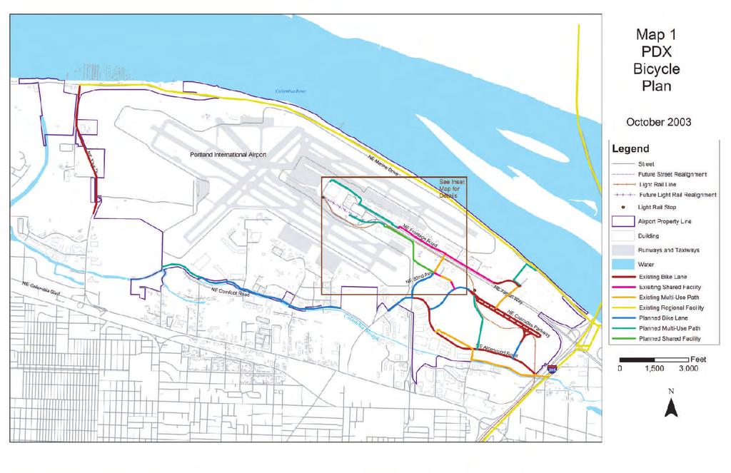
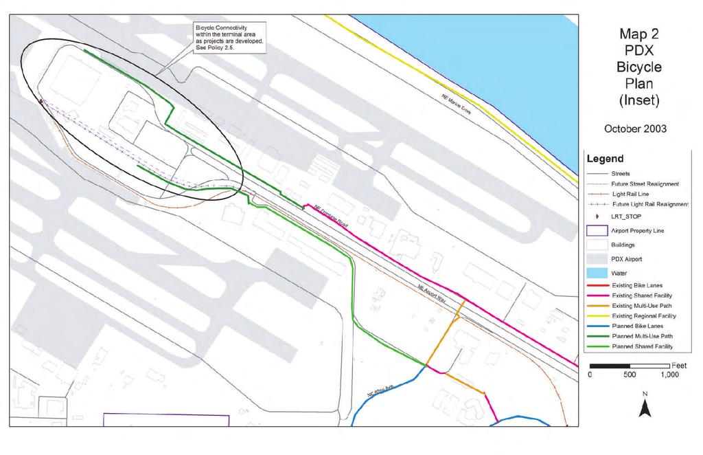
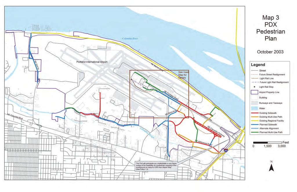
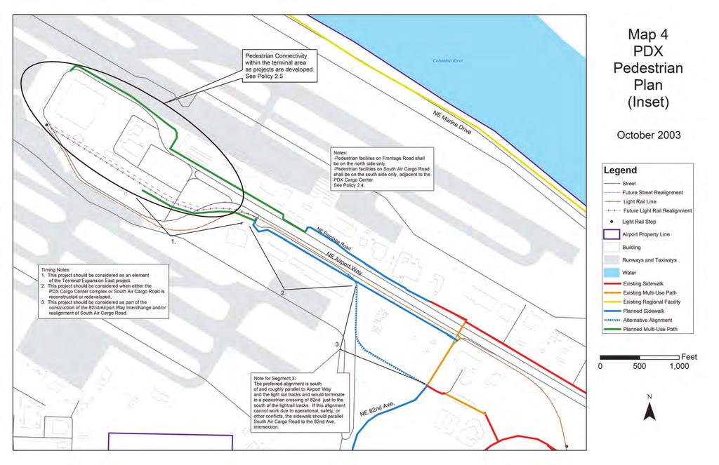
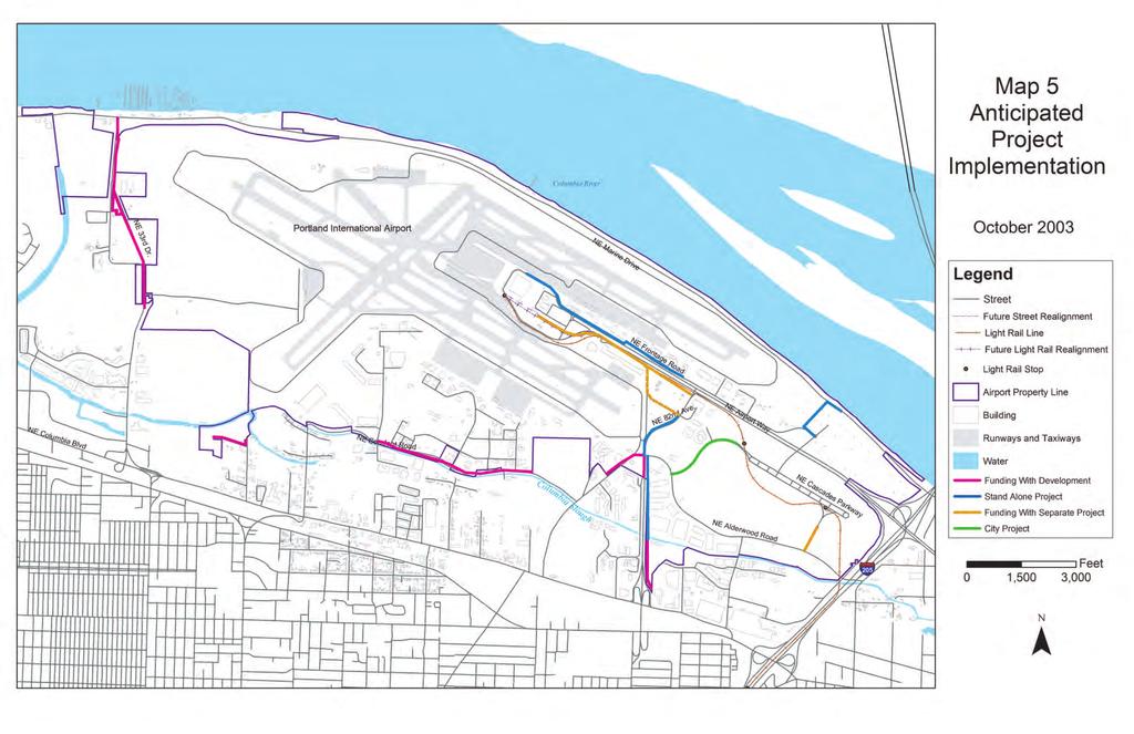
2 TABLE OF CONTENTS Plan Scope Introduction Planning Background Policies Map 1 PDX Bicycle Plan (full view) Map 2 PDX Bicycle Plan, Terminal Area Inset Map 3 PDX Pedestrian Plan (full view) Map 4 PDX Pedestrian Plan, Terminal Area Inset Map 5 Anticipated Project Implementation Plan Implementation. 13 PDX Bicycle and Pedestrian Plan
3 (October 2003) Plan Scope This plan is intended to address bicycle and pedestrian facility and circulation needs on the landside of Portland International Airport (PDX) property. This area includes Port owned lands, Port owned roadways, and City streets within and abutting Port property. This plan is not intended to address land on the airfield or within the terminal building. The PDX Bicycle and Pedestrian Plan consists of policies, strategies, and maps that define and support the bike and pedestrian network and guide its continued development. Consistent with all plans for future improvements at PDX, all future facilities in this plan reflect the Port of Portland s current best understanding and intent of how to address the Port s identified future needs. All future projects are subject to future modification based on many factors, including but not limited to airport growth, policy changes at the federal, state, local or internal level, funding limitations, or significant changes in assumed airport facilities. Introduction Historically, bicycle and pedestrian planning has been a low priority in the United States. This has been especially true at commercial service airports where addressing bicycle and pedestrian access has been a low priority (including at PDX) or has been ignored altogether. The reasons for this likely include the belief that these modes are inconvenient for travelers with baggage in terms of time, distance, and effort, plus the fact that the FAA does not fund, nor encourages the spending of airport money on the construction of such facilities. Since the early 1990 s much has changed regarding planning for these modes. Changes to legislation at the federal level (Intermodal Surface Transportation Efficiency Act of 1991) and state level (Oregon Transportation Planning Rule) shifted the transportation focus from building highways to developing and implementing multi-modal transportation systems that offer more transportation choices to people, reduce congestion, improve air quality, and save money. By the mid to late 1990 s this policy shift had become well integrated into transportation planning and financing at the federal (except FAA), state, regional and local levels. At the same time, public awareness about, demand for, and use of these modes (especially bicycles) increased significantly in the Portland region. At PDX, there was an increasing demand, mostly from the many airport employees, to provide safe and convenient bicycle facilities to the terminal. In addition, there was increasing demand to add pedestrian connections between
4 various on-airport activity nodes, especially between on-airport hotels and the terminal as well as to the then anticipated Airport Max light rail stations. By 1998, the Port of Portland, recognizing the following factors, determined that it should develop its own plan for implementing bicycle and pedestrian improvements on airport grounds: Increasing employee and public demand for bicycle and pedestrian facilities at PDX. The Port needed to demonstrate that it was fully committed to multi-modal transportation planning even though bicycle and pedestrian transportation planning was not mandated on the Port by any federal, state, regional, or local policy or regulation. Consistency with a newly created PDX Alternative Modes Strategy. The Port needed to identify its own preferred system for these modes prior to the August 2003 expiration of the airport s conditional use permit. The Port needed to identify bicycle and pedestrian improvement priorities to be used in development of a number of large access projects that were beginning in the near future including Airport Max, Airport Way Widening, CascadeStation and Mt. Hood Interchange. By early 1999, the Port had commissioned its first bicycle and pedestrian planning study. Planning Background CascadeStation/Portland International Center Plan District In 1998 the City of Portland initiated the planning work necessary to adopt a new CascadeStation/Portland International Center (CS/PIC) plan district. The plan district was needed to provide mixed-use development that would support light rail transit investments being made for Airport Max. The CS/PIC Plan District was adopted by City Council in February One element of this plan district was a pedestrian and bicycle circulation system that called for bike lanes and sidewalks along the interior public street corridors supplemented by three mixed-use trails that connect Ambassador Place with 82 nd Avenue, connect Alderwood Road (near 92 nd Avenue) with the Mt. Hood light rail station, and
5 connect the Cascade Parkway east circle with Airport Way near the I-205 southbound on-ramp. In October of 2000, City Council adopted amendments to the CS/PIC Plan District that included the removal of the mixed-use trail connection between the Cascade Parkway east circle with Airport Way near the I-205 southbound onramp. The City action states that this facility was removed because that connection was hazardous, because it required crossing a ramp of I-205. East Airport Area Bicycle and Pedestrian Study In 1999, the Port commissioned Browning/Shono Architects to conduct the East Airport Area Bicycle and Pedestrian Study. The goal of the study was to identify, analyze, and provide solutions for pedestrian and bicycle gaps in ground access to the airport terminal and its adjacent facilities. Study objectives included, 1) identify critical gaps in pedestrian and bicycle access, 2) map existing and proposed routes, 3) develop a phasing plan, 4) identify implementation issues, and 5) determine bicycle parking and end of trip facility needs. Study stakeholders included ODOT, Metro, City of Portland, the Bicycle Transportation Alliance, the Willamette Pedestrian Coalition, and the Columbia Corridor Association. Stakeholder participation in the process varied. It is important to note that while the City of Portland provided excellent input from the City Bicycle Coordinator, the City Pedestrian Coordinator position was vacant at that time. In addition, the representative from the Willamette Pedestrian Coalition was not able to attend project meetings. As a result, the pedestrian element of this study was under-represented. Conversely, the bicycle element of this study had extensive participation, review, and was enthusiastically supported by agency representatives and bicycle interest groups. The study focused on the front door or east side of the airport where the vast majority of trips are located. Existing needs on the south side of the airport (Alderwood and Cornfoot Roads) and future needs at the west end of the airport (33 rd Ave Corridor) were not considered. Priority destinations for the study included the terminal building, Portland International Center (especially the light rail stations), Frontage Road properties, and connections to the existing regional pedestrian and bicycle network. The study reviewed all possible connections between priority destinations and other activity locations and ranked them using the following criteria:
6 Mode Benefit How many modes would the facility benefit and to what degree? User Benefit What is the relative number/category of potential users? Serves Local Destinations Does the facility provide connectivity to one or more priority local destinations? Makes Network Connections - Does the facility represent a system addition for one or more modes? General Performance - How good is the relative safety, convenience and ambience of the facility? Traffic System - To what degree will the project degrade traffic performance? Based on these criteria, a preferred network of bicycle and pedestrian facilities for the east airport area was determined. This preferred network was centered around the following three primary conclusions that grew out of the evaluation process: Airport Way/Frontage Road The Browning/Shono study states, The basic recommendation for the Airport Way Corridor is to build a parallel facility for bikes and pedestrians using Frontage Road, with new pathway connectors at the west and east ends. This recommendation was primarily based on the future plans for a freeway like Airport Way with interchanges and braided ramps, coupled with the fact that Frontage Road provided a better opportunity because it closely parallels Airport Way, has significantly lower traffic volumes and speeds, and has land uses along its north side. Air Cargo Way Provide for bike and pedestrian crossings of 82 nd at its intersection with Air Cargo Road. Provide for a terminal connection when light rail and the terminal access roadway are realigned in the future. 82 nd Avenue Provide for a safe bicycle and pedestrian crossing of Airport Way at 82 nd Avenue. Provide an east-side mixed-use facility between Airport Way and Air Cargo Road The result of this work became the PDX Bicycle and Pedestrian Plan. Not long after this plan was complete, the Airport Way Widening Project attempted to incorporate the recommended mixed-use facility running east-west on the north side of Airport Way between the new Mt. Hood Interchange and Marine Drive. This facility was found to be impracticable due to the presence of wetlands near I-205. With the input of many on the study stakeholder team, this connection was then replaced on the plan with a north-south mixed use connection between Mt. Hood Avenue and Marine Drive. City of Portland TSP
7 In 2002, the City of Portland was in the final stages of adopting a transportation system plan that would conform to the state transportation planning rule requirements. Late in the city process, the Port became aware that the draft city plan was inconsistent with the PDX Bicycle and Pedestrian Study recommendation to not build bike lanes and sidewalks along Airport Way. It was agreed that it was too late in the adoption process to change the system maps, so the City and Port agreed to the following language to be added to the plan. Reevaluate the pedestrian and bicycle designations between the Portland International Airport terminal and I-205, in conjunction with the update of the airport s conditional use master plan or a legislative action creating a plan district, with the goal of making complete pedestrian and bicycle connections between the terminal, Cascade Station, and Airport Way east of I-205, including through the Airport Way/Mt. Hood Interchange. It was further agreed that the PDX Bicycle and Pedestrian Plan would be included in the Conditional Use Master Plan application, and if approved through that process, the City would amend its transportation system plan to reflect the approval. PDX Conditional Use Master Plan (CUMP) In the fall of 2002, the Port submitted its CUMP application to the City that included the PDX Bicycle and Pedestrian Plan. Because the pedestrian element of the plan was under-represented during its development, the City and Port agreed that the Port should work with the City Pedestrian Coordinator and City Pedestrian Advisory Committee (PAC) to seek support for the pedestrian element. Any resulting changes to the pedestrian element would supplement the CUMP application for City approval. After meeting with the PAC, consensus was reached on a number of proposed changes to the plan. The one major area of disagreement was planning for a pedestrian crossing of the Airport Way/I-205 southbound on-ramp. The PAC strongly desired such a connection. The Port did not find that such a crossing would be safe, economically feasible or practicable. In summary, the consensus changes added 1) a pedestrian corridor between the south side of the terminal to the Air Cargo Road Corridor to 82 nd Avenue, 2) required bicycle and pedestrian connectivity to be design considerations as the terminal area is expanded, and 3) commits the Port to participate in any future review of a potential pedestrian
8 crossing of the Airport Way/I-205 southbound on-ramp. The consensus changes were submitted to the City to be considered in the CUMP application. The PDX Bicycle and Pedestrian Plan was approved through the CUMP process by the City Hearings Officer and subsequently City Council with a condition that the Port present to the City six copies of the revised plan within three months. This plan is intended to meet that condition as well as provide a complete and understandable plan for use by the Port, other agencies, and the general public. FAA Issues The FAA generally does not encourage the expenditure of aviation funds for bicycle and pedestrian improvements at airports. Such improvements are not eligible for federal airport improvement grants nor are they usually eligible for the expenditure of airport-generated Passenger Facility Charges. In addition, in implementing its federal revenue diversion policy, the FAA is leery of the expenditure of any other locally-generated airport funds for bicycle and pedestrian improvements anywhere on airport property that may be used by significant numbers of non-airport users. In 2003, the FAA requested that the Port certify that the planned bicycle and pedestrian network on our airport was primarily for airport related users. A written certification was presented and subsequently approved by the FAA.
9 PDX Bicycle and Pedestrian Plan Policies 1.0 BICYCLE AND PEDESTRIAN PLANNING POLICY IT IS THE POLICY OF THE PORT OF PORTLAND TO PLAN FOR BICYCLE AND PEDESTRIAN ACCESS AS ALTERNATIVE ACCESS MODES AT PORTLAND INTERNATIONAL AIRPORT Strategies: 1.1 Include bicycle and pedestrian access and circulation as an element in broader facility planning at Portland International Airport. Examples include master plan updates and major airport access planning studies. 1.2 Participate at Metro in bicycle and pedestrian planning as part of proposed amendments to the West Columbia Corridor Subarea of the Regional Transportation Plan. 1.3 Participate at the City of Portland in bicycle and pedestrian planning as part of proposed amendments to the Northeast and Far Northeast Transportation Planning areas of the City of Portland Transportation System Plan. 1.4 Ensure that planned bicycle and pedestrian facilities on airport property are consistent with the FAA Revenue Diversion Policy and any other FAA regulations or requirements. 1.5 Participate as a stakeholder in any future review of the feasibility of a pedestrian crossing of the southbound on-ramp to I-205 from Airport Way. Other participants should include ODOT, PDOT, and CascadeStation Development Company. Such a review should balance the need for direct pedestrian connections with the policy, operational, safety, and financial impacts of such a crossing. 2.0 BICYCLE AND PEDESTRIAN FACILITY POLICY IT IS THE POLICY OF THE PORT OF PORTLAND TO ENCOURAGE AND SUPPORT BICYCLE AND PEDESTRIAN ACTIVITY ON THE LANDSIDE OF PORTLAND INTERNATIONAL AIRPORT BY PROVIDING FACILITIES THAT ARE SAFE AND CONVENIENT Strategies:
10 2.1 Plan for and build bicycle and pedestrian facilities that provide reasonably direct connections between activity nodes on-airport and provide connections to the surrounding regional bicycle and pedestrian system. 2.2 When constructing bicycle and pedestrian facilities, use City of Portland and/or State of Oregon construction standards whenever practicable. 2.3 Avoid placing bicycle or pedestrian facilities along Airport Way except in the terminal area. Use parallel roadway corridors for bicycle and pedestrian facilities. 2.4 Pedestrian facilities along Frontage Road shall be on the north side only. Pedestrian facilities along South Air Cargo Road adjacent to the PDX Cargo Center shall be on the south side only. 2.5 Include bicycle and pedestrian connectivity within the terminal area as a design consideration as Terminal Expansion East (TEE) and TEE precursor projects are developed. 2.6 Include safe and convenient bicycle and pedestrian facilities in the design of the future interchange at the intersection of Airport Way and 82 nd Avenue. 2.7 Require new airport tenant development to construct planned pedestrian and bicycle facilities whenever practicable. PDX Bicycle and Pedestrian Plan Maps The following five maps graphically represent this plan Map 1 - PDX Bicycle Plan (full view) Map 2 - PDX Bicycle Plan, Terminal Area Inset Map 3 - PDX Pedestrian Plan (full view) Map 4 - PDX Pedestrian Plan Terminal Area Inset Map 5 - Anticipated Project Implementation
11
12
13
14
15
16 Plan Implementation Funding Sources While there are a number of funding sources available to airports generally, many of these funds are reserved for improvements that directly impact the safety, capacity and operation of airplanes and the airlines at the airport. With the exception of PFC s (see below), any airport funds that need airline approval to spend or any FAA grants may not be considered to fund any of the improvements anticipated in this plan. The following revenue sources are available for funding improvements in this plan. Port Cost Center The Port Cost Center is comprised of airport funds generated predominately by airport parking and rental car revenues. With the exception of federal revenue diversion regulations, these funds are controlled by and can be used at the sole discretion of the Port. It is anticipated that most of the bicycle and pedestrian improvements in the plan will be funded from this source. Developer In some limited cases, facilities in this plan will be constructed associated with on-airport land development. For example, the mixed-use facility in PIC that connects Ambassador Place with 82 nd Avenue was built by a private developer who leased the abutting land to build. Construction of the mixed-use path was a requirement of the lease. No airport money is used in these cases. Passenger Facility Charges (PFC s) PFC s are fees imposed by an airport on enplaning passengers when departing or connecting. The fees are then used by the airport to fund FAA-approved projects that enhance safety, security, or capacity; reduce noise; or increase air carrier competition. While the use of PFC s will not be approved for stand alone bicycle or pedestrian projects, it is possible that they can be used to fund some of these elements as part of a larger airport access project such as a new or realigned airport access road. The Port will seek PFC funding for bicycle and pedestrian elements whenever possible. Project Implementation This plan includes a map (Map 5) which shows the anticipated funding type for each of the planned (non-existing) facilities noted on Maps 1 through 4. It is important to note that this map reflects only the Port s current best estimate
17 about how these projects will be implemented. Map 5 is non-prescriptive, and no amendment to this map is necessary if the Port or others are able to complete. Plan Amendments The Port of Portland is not required to adopt plans that address and are consistent with Oregon s statewide planning goals. Therefore, there is no state mandated public involvement or adoption process that must be followed to adopt or amend this or any other Port plan. The Port does however conduct extensive planning to address our future needs, which includes a strong public involvement element. The current PDX Bicycle and Pedestrian Plan had extensive public involvement through the East Airport Area Bicycle and Pedestrian Study, the City Pedestrian Advisory Committee process, and the CUMP adoption. Finally, the Port anticipates that the City will adopt amendments to its transportation system plan to be consistent with this plan in the near future. When considering changes to this plan, the Port will employ the following process: Check with the City of Portland to see if the proposed change is consistent with the City Transportation System Plan If yes, then consult with the City Bicycle Coordinator, Pedestrian Coordinator, and/or ODOT Bicycle & Pedestrian Coordinator, as appropriate, to get input on issues to consider prior to implementation. Implement the change with any appropriate modifications. If no, then consult with City about the process needed to amend the City transportation system plan consistent with the proposal including stakeholder and public involvement processes. The Port would then consider taking the proposed amendment to the City Bicycle Advisory Committee and/or Pedestrian Advisory Committee, as appropriate, for their input and recommendation. Based on this input, the Port would then make a decision about whether to proceed with a request to change the City transportation plan. While not required, it is expected that any significant changes will be supported by a study.
Basalt Creek Transportation Refinement Plan Recommendations
 Basalt Creek Transportation Refinement Plan Recommendations Introduction The Basalt Creek transportation planning effort analyzed future transportation conditions and evaluated alternative strategies for
Clackamas County Comprehensive Plan
 ROADWAYS The County s road system permits the movement of goods and people between communities and regions, using any of a variety of modes of travel. Roads provide access to virtually all property. They
CITY OF COCOA BEACH 2025 COMPREHENSIVE PLAN. Section VIII Mobility Element Goals, Objectives, and Policies
 CITY OF COCOA BEACH 2025 COMPREHENSIVE PLAN Section VIII Mobility Element Goals, Objectives, and Policies Adopted August 6, 2015 by Ordinance No. 1591 VIII MOBILITY ELEMENT Table of Contents Page Number
2. NORTEL CARLING CAMPUS EXPANSION - PROPOSED MODIFICATIONS TO MOODIE DRIVE (REGIONAL ROAD 59) AND HIGHWAY 417 INTERCHANGE
 AND HIGHWAY 417 INTERCHANGE") 2. NORTEL CARLING CAMPUS EXPANSION - PROPOSED MODIFICATIONS TO MOODIE DRIVE (REGIONAL ROAD 59) AND HIGHWAY 417 INTERCHANGE COMMITTEE RECOMMENDATIONS AS AMENDED That Council approve: 1. The endorsement
2. NORTEL CARLING CAMPUS EXPANSION - PROPOSED MODIFICATIONS TO MOODIE DRIVE (REGIONAL ROAD 59) AND HIGHWAY 417 INTERCHANGE COMMITTEE RECOMMENDATIONS AS AMENDED That Council approve: 1. The endorsement
ACTIVE TRANSPORTATION/NONMOTORIZED TRANSPORTATION
 ACTIVE TRANSPORTATION/NONMOTORIZED TRANSPORTATION BACKGROUND Active transportation, also known as nonmotorized transportation, is increasingly recognized as an important consideration when planning and
Circulation in Elk Grove includes: Motor vehicles, including cars and trucks
 Circulation, as it is used in this General Plan, refers to the many ways people and goods move from place to place in Elk Grove and the region. Circulation in Elk Grove includes: Motor vehicles, including
Corpus Christi Metropolitan Transportation Plan Fiscal Year Introduction:
 Introduction: The Safe, Accountable, Flexible, Efficient Transportation Equity Act: A Legacy for Users (SAFETEA-LU) has continued the efforts started through the Intermodal Surface Transportation Efficiency
4. ENVIRONMENTAL IMPACT ANALYSIS 9. TRANSPORTATION AND TRAFFIC
 4. ENVIRONMENTAL IMPACT ANALYSIS 9. TRANSPORTATION AND TRAFFIC 4.9.1 INTRODUCTION The following section addresses the Proposed Project s impact on transportation and traffic based on the Traffic Study
SANTA CLARA COUNTYWIDE BICYCLE PLAN August 2008
 SANTA CLARA COUNTYWIDE BICYCLE PLAN August 2008 To assist VTA and Member Agencies in the planning, development and programming of bicycle improvements in Santa Clara County. Vision Statement To establish,
Corporate. Report COUNCIL DATE: June 26, 2006 NO: C012 COUNCIL-IN-COMMITTEE. TO: Mayor & Council DATE: June 22, 2006
 Corporate NO: C012 Report COUNCIL DATE: June 26, 2006 COUNCIL-IN-COMMITTEE TO: Mayor & Council DATE: June 22, 2006 FROM: General Manager, Engineering FILE: 0410-20(MoT/Gate) SUBJECT: Surrey Response on
STUDY ADVISORY COMMITTEE. October 8, 2015
 STUDY ADVISORY COMMITTEE October 8, 2015 Study Purpose evaluate the long-term transportation strategies and investments needed to sustain the county s economic health and quality of life in the coming
Preliminary Transportation Analysis
 Preliminary Transportation Analysis Goals of a Robust, Multimodal Transportation Network Safe Accessible/Connected Efficient Comfortable Context-Sensitive Motor Vehicle: Continue to analyze the data to
Tulsa Metropolitan Area LONG RANGE TRANSPORTATION PLAN
 Tulsa Metropolitan Area LONG RANGE TRANSPORTATION PLAN Indian Nations Council of Governments August 2005 CONTACTING INCOG In developing the Destination 2030 Long Range Transportation Plan, INCOG s Transportation
Non-Motorized Transportation 7-1
 Non-Motorized Transportation 7-1 Transportation facilities no longer mean just accommodating a vehicle powered by a combustion engine. Pedestrian and non-motorized facilities are important modes of travel
WEST AND SOUTH WEST RING ROAD DOWNSTREAM TRAFFIC IMPACTS
 Page 1 of 9 EXECUTIVE SUMMARY Alberta Transportation ( AT ) is preparing to construct the final sections of the Calgary Ring Road. This includes the South West Ring Road ( SWRR ) (from Lott Creek Blvd
City of Novi Non-Motorized Master Plan 2011 Executive Summary
 City of Novi Non-Motorized Master Plan 2011 Executive Summary Prepared by: February 28, 2011 Why Plan? Encouraging healthy, active lifestyles through pathway and sidewalk connectivity has been a focus
Bicycle Master Plan Goals, Strategies, and Policies
 Bicycle Master Plan Goals, Strategies, and Policies Mobilizing 5 This chapter outlines the overarching goals, action statements, and action items Long Beach will take in order to achieve its vision of
City of Hamilton s Transportation Master Plan (TMP) Public Consultation 3 December 2015
 Public Consultation 3 December 2015") City of Hamilton s Transportation Master Plan (TMP) Public Consultation 3 December 2015 McPhail Transportation Planning Services Ltd. AGENDA 6:00 7:00 pm Viewing Boards / Q & A with the Team 7:00 7:50
City of Hamilton s Transportation Master Plan (TMP) Public Consultation 3 December 2015 McPhail Transportation Planning Services Ltd. AGENDA 6:00 7:00 pm Viewing Boards / Q & A with the Team 7:00 7:50
Transportation Master Plan Advisory Task Force
 Transportation Master Plan Advisory Task Force Network Alternatives & Phasing Strategy February 2016 BACKGROUND Table of Contents BACKGROUND Purpose & Introduction 2 Linking the TMP to Key Council Approved
City of Charlottesville Bicycle and Pedestrian Master Plan Update
 City of Charlottesville Bicycle and Pedestrian Master Plan Update September 17, 2014 I. Welcome and meeting overview II. Project status update III. Network overview IV. Break-out groups Pedestrian Network
Arterial Management Plan for US Route 250 and State Route 623
 Arterial Management Plan for US Route 250 and State Route 623 June 25, 2014 Brad Shelton, AICP Access Management and Traffic Impact Analysis Programs Manager Transportation and Mobility Planning Division
Exhibit 1 PLANNING COMMISSION AGENDA ITEM
 Exhibit 1 PLANNING COMMISSION AGENDA ITEM Project Name: Grand Junction Circulation Plan Grand Junction Complete Streets Policy Applicant: City of Grand Junction Representative: David Thornton Address:
Highway 217 Corridor Study. Phase I Overview Report
 Highway 217 Corridor Study Phase I Overview Report November 3, 24 BACKGROUND AND OVERVIEW Study purpose The Highway 217 Corridor Study is developing multi-modal transportation solutions for traffic problems
University of Victoria Campus Cycling Plan Terms of Reference. 1.0 Project Description
 University of Victoria Campus Cycling Plan Terms of Reference 1.0 Project Description The Campus Cycling Plan, a first for the University, will provide a comprehensive and coordinated approach to support
Public Event 1 Community Workshops
 Public Event 1 Community Workshops Nov. 24 & Dec. 3, 2016 Welcome Workshop Purpose We re looking to you for ideas and insights to help guide future transportation infrastructure planning in the Park Lawn
Figure 1: East West Connector Alignment Alternatives Concept Drawing
 Page 2 of 9 Figure 1: East West Connector Alignment Alternatives Concept Drawing The Montebello Drive extension will run north south and connect Wilsonville Road to the Boones Ferry Road to Brown Road
TRAFFIC IMPACT STUDY CRITERIA
 Chapter 6 - TRAFFIC IMPACT STUDY CRITERIA 6.1 GENERAL PROVISIONS 6.1.1. Purpose: The purpose of this document is to outline a standard format for preparing a traffic impact study in the City of Steamboat
Highway 49, Highway 351 and Highway 91 Improvements Feasibility Study Craighead County
 Highway 49, Highway 351 and Highway 91 Improvements Feasibility Study Craighead County Executive Summary March 2015 Highway 49, Highway 351 and Highway 91 Improvements Feasibility Study Craighead County
Washington DC Section of ITE Project Briefing
 Washington DC Section of ITE Project Briefing November 5, 2015 Renée Hamilton, VDOT, Deputy District Administrator I-66 Outside the Beltway Improvement Area Project Location Virginia 2 Purpose and Need
Memorandum. Fund Allocation Fund Programming Policy/Legislation Plan/Study Capital Project Oversight/Delivery Budget/Finance Contract/Agreement Other:
 Memorandum Date: November 20, 2017 To: Transportation Authority Board From: Eric Cordoba Deputy Director Capital Projects Subject: 12/5/17 Board Meeting: San Francisco Freeway Corridor Management Study
SANTA MONICA BOULEVARD CORRIDOR
 CIRCULATION ELEMENT WHITE PAPER NO. 3 SANTA MONICA BOULEVARD CORRIDOR INTRODUCTION From the 1930s to the beginning of Los Angeles freeway era, Santa Monica Boulevard, (previously Route 66, the Beverly
CONNECTING PEOPLE TO PLACES
 CONNECTING PEOPLE TO PLACES 82 EAST BENCH MASTER PLAN 07 Introduction The East Bench transportation system is a collection of slow moving, treelined residential streets and major arteries that are the
Chapter 7. Transportation. Transportation Road Network Plan Transit Cyclists Pedestrians Multi-Use and Equestrian Trails
 Chapter 7 Transportation Transportation Road Network Plan Transit Cyclists Pedestrians Multi-Use and Equestrian Trails 7.1 TRANSPORTATION BACKGROUND The District of Maple Ridge faces a number of unique
RESOLUTION NO ?? A RESOLUTION OF THE CITY OF NEPTUNE BEACH ADOPTING A COMPLETE STREETS POLICY
 RESOLUTION NO. 2018-?? A RESOLUTION OF THE CITY OF NEPTUNE BEACH ADOPTING A COMPLETE STREETS POLICY WHEREAS, safe, convenient, and accessible transportation for all users is a priority of the City of Neptune
Southwest Bus Rapid Transit (SW BRT) Functional Planning Study - Executive Summary January 19 LPT ATTACHMENT 2.
 Functional Planning Study - Executive Summary January 19 LPT ATTACHMENT 2.") Southwest Bus Rapid Transit (SW BRT) Functional Planning Study - Executive Summary 2011 January 19 1 of 19 Introduction This executive summary presents the results of the Southwest Bus Rapid Transit (SW
Southwest Bus Rapid Transit (SW BRT) Functional Planning Study - Executive Summary 2011 January 19 1 of 19 Introduction This executive summary presents the results of the Southwest Bus Rapid Transit (SW
San Jose Transportation Policy
 San Jose Transportation Policy Protected Intersections in LOS Policies to Support Smart Growth Presented by: Manuel Pineda City of San Jose Department of Transportation Bay Area Map San Francisco Oakland
The Florida Bicycle and Pedestrian Partnership Council
 The Florida Bicycle and Pedestrian Partnership Council Input to the Update of the Florida Transportation Plan March 2015 This document presents input from the Florida Bicycle and Pedestrian Advisory Council
CITY OF VAUGHAN EXTRACT FROM COUNCIL MEETING MINUTES OF OCTOBER 30, 2012
 CITY OF VAUGHAN EXTRACT FROM COUNCIL MEETING MINUTES OF OCTOBER 30, 2012 Item 31, Report No. 39, of the Committee of the Whole, which was adopted without amendment by the Council of the City of Vaughan
Evolving Roadway Design Policies for Walking and Bicycling
 Evolving Roadway Design Policies for Walking and Bicycling The 2016 Michigan Transportation Planning Conference Kalamazoo, MI July 13, 2016 Title 23 of the Code of Federal Regulations Title 23 was originally
 MEMORANDUM - CITY OF PASADENA Department Of Transportation DATE: OCTOBER 21, 2008 TO: ENVIRONMENTAL ADVISORY COMMISSION FROM: ~ FRED C. DOCK, DIRECTOR OF TRANSPORTATION SUBJECT: UPDATE ON DEPT. OF TRANSPORTATION
Downtown Naples Mobility and Connectivity Study. Naples City Council Presentation January 2017
 Downtown Naples Mobility and Connectivity Study Naples City Council Presentation January 2017 Agenda 1. Introduction 2. Scope Review 3. Project Schedule 4. Existing Conditions 5. Public Charrette 6. Mobility
In station areas, new pedestrian links can increase network connectivity and provide direct access to stations.
 The Last Mile Planning for Pedestrians Planning around stations will put pedestrians first. Making walking to stations safe and easy is important; walking will be a part of every rapid transit Accessible
CITY OF BLOOMINGTON COMPLETE STREETS POLICY
 CITY OF BLOOMINGTON COMPLETE STREETS POLICY POLICY OBJECTIVE: The City of Bloomington will enhance safety, mobility, accessibility and convenience for transportation network users of all ages and abilities,
Executive Summary Route 30 Corridor Master Plan
 Route Corridor Master Plan Project Overview The Route Corridor Master Plan is a coordinated multimodal transportation and land use plan for the entire stretch of Route through East Whiteland Township,
2045 Long Range Transportation Plan. Summary of Draft
 2045 Long Range Transportation Plan Summary of Draft Fredericksburg Area Metropolitan Planning Organization The George Washington Region includes the City of Fredericksburg and the counties of Caroline,
Summary: Mercer County Princeton Avenue & Spruce Street Study January 2009
 Summary: Several recent studies have assessed potential development and redevelopment opportunities in the Mercer Crossing area of Trenton, Ewing, and Lawrence. This Princeton Avenue and Spruce Street
Route 29 Solutions Projects
 Route 29 Solutions Route 29 Solutions Projects www.route29solutions.org October 10, 2014 Route 29 Widening to Six Lanes Albemarle County This project will widen a 1.8-mile segment of Route 29 from four
NOTICE OF PREPARATION. Environmental Programs 3331 North First Street, Building B-2 San Jose, CA
 NOTICE OF PREPARATION May 29, 2018 To: Reviewing Agencies and Organizations From: Santa Clara Valley Transportation Authority Environmental Programs 3331 North First Street, Building B-2 San Jose, CA 95134-1927
City of Gainesville Transportation/Roadway Needs PROJECT SUMMARY
 A1 Roadway Resurfacing $23,846,000 TYPE: Preservation of existing system Roadway resurfacing A2 Signal Replacement $6,000,000 TYPE: Preservation of existing system Replace traffic signals. B1 W 6th St
Governor s Transportation Vision Panel
 Office of Governor Kate Brown Governor s Transportation Vision Panel JLA Public Involvement Project Overview The is a yearlong effort to develop a series of recommendations for the Governor that address
Bikeway action plan. Bicycle Friendly Community Workshop March 5, 2007 Rochester, MN
 Bikeway action plan Summary The was held on March 5, 2007 at the Rochester Mayo Civic Center. The workshop was hosted by Rochester-Olmsted County Planning Department in collaboration with the League of
Corridor Advisory Group and Task Force Meeting #10. July 27, 2011
 Corridor Advisory Group and Task Force Meeting #10 July 27, 2011 1 Agenda Recap CAG/TF #9 Public Meeting #2 Summary Single Mode Alternatives Evaluation Results Next Steps 2 3 CAG/TF #9 Recap CAG /TF #9
Transportation Authority of Marin Renew Existing ½-cent Transportation Sales Tax
 Transportation Authority of Marin Renew Existing ½-cent Transportation Sales Tax Request for Approval of the Final Sales Tax Renewal Expenditure Plan Town of Tiburon June 20, 2018 Request Council to Approve
Physical Implications of Complete Streets Policies
 Presentation Overview Physical Implications of Complete Norm Cox, ASLA, LLA Landscape Architect Ann Arbor, Michigan, 10:45 to Noon What Are Complete Streets? What Matters to Bicyclists and Pedestrians
INTERMODAL TRANSPORTATION PLAN
 INTRODUCTION INTERMODAL TRANSPORTATION PLAN Effective intermodal transportation implies a public policy for actively decreasing the demand for automobile trips and consequently reducing automobile related
City of Atlanta-MARTA Sales Tax Referendum Draft Project List. Atlanta City Council Work Session May 19, 2016
 1 City of Atlanta-MARTA Sales Tax Referendum Draft Project List Atlanta City Council Work Session May 19, 2016 2 SB 369 - MARTA Sales tax for up to 0.50% is allowed in the City of Atlanta for MARTA Purpose
Goodlettsville Bicycle and Pedestrian Plan Executive Summary
 Goodlettsville Bicycle and Pedestrian Plan July 2010 In Cooperation with the Nashville Area Metropolitan Planning Executive Organization Summary Introduction Progressive and forward thinking communities
ROUTES 55 / 42 / 676 BUS RAPID TRANSIT LOCALLY PREFERRED ALTERNATIVE
 ROUTES 55 / 42 / 676 BUS RAPID TRANSIT LOCALLY PREFERRED ALTERNATIVE April, 2012 1 INTRODUCTION The need for transit service improvements in the Routes 42/55/676 corridor was identified during the Southern
City of Moorhead Committee of the Whole Meeting
 City of Moorhead Committee of the Whole Meeting Corridor Study Limits Center Avenue (Red River to 8th Street) TH 10 (Red River to TH 336) TH 75 (20th Ave S to Main Avenue) 2 Study Need: Project Overview
The Route 29 Corridor Study was initiated at the request of Virginia s Commonwealth
 CHAPTER 2: Study Background and approach The Route 29 Corridor Study was initiated at the request of Virginia s Commonwealth Transportation Board in response to requests from members of the General Assembly
Regional Transportation Needs Within Southeastern Wisconsin
 Regional Transportation Needs Within Southeastern Wisconsin #118274 May 24, 2006 1 Introduction The Southeastern Wisconsin Regional Planning Commission (SEWRPC) is the official areawide planning agency
Thank you for attending the first Public Open House for the Thunder Bay Transportation Master Plan!
 Welcome Thank you for attending the first Public Open House for the Thunder Bay Transportation Master Plan! Please take this opportunity to learn about the study and to tell us your ideas and vision for
ADOT Statewide Bicycle and Pedestrian Program Summary of Phase IV Activities APPENDIX B PEDESTRIAN DEMAND INDEX
 ADOT Statewide Bicycle and Pedestrian Program Summary of Activities APPENDIX B PEDESTRIAN DEMAND INDEX May 24, 2009 Pedestrian Demand Index for State Highway Facilities Revised: May 29, 2007 Introduction
Goal 3: Foster an environment of partnerships and collaboration to connect our communities and regions to one another.
 Non-Motorized Transportation Plan (NMTP) Draft Vision, Goal and,, Tri-County Regional Planning Commission (TCRPC) Purpose The purpose of the Tri-County Regional Planning Commission (TCRPC) Non-Motorized
Solana Beach Comprehensive Active Transportation Strategy (CATS)
") Solana Beach Comprehensive Active Transportation Strategy (CATS) 3.0 Goals & Policies The Solana Beach CATS goals and objectives outlined below were largely drawn from the Solana Beach Circulation Element
Solana Beach Comprehensive Active Transportation Strategy (CATS) 3.0 Goals & Policies The Solana Beach CATS goals and objectives outlined below were largely drawn from the Solana Beach Circulation Element
US 1 Express Lanes Public Kick-Off Meeting
 US 1 Express Lanes Project Development & Environment (PD&E) Study Public Kick-Off Meeting September 7 & 8, 2011 Miami Dade County, Florida 1 Presentation Agenda Introduction to MDX Background to PD&E studies
FM #: ETDM #: 11241
 SR 826/Palmetto Expressway PD&E Study From SR 93/I 75 to the Golden Glades Interchange FM #: 418423 1 22 01 ETDM #: 11241 Agency/ Kick Off Meeting October 27, 2011 2 Location Map From SR 93/I 75 to Golden
Main-McVay Transit Study: Phase 2 Options Definition and High Level Constraints Evaluation
 Main-McVay Transit Study: Phase 2 Options Definition and High Level Constraints Evaluation APRIL 2016 A collaborative study between: For Additional Information or to Comment If you would like additional
General Plan Circulation Element Update Scoping Meeting April 16, 2014 Santa Ana Senior Center, 424 W. 3rd Street, Santa Ana, CA 92701
 General Plan Circulation Element Update Scoping Meeting April 16, 2014 Santa Ana Senior Center, 424 W. 3rd Street, Santa Ana, CA 92701 Meeting Agenda 1. Purpose of Scoping Meeting 2. Project Overview 3.
Florida Department of Transportation District Four. I-95 at 6 th Avenue Interchange Improvements FDOT PM - Fernando Morales, PE
 1 Florida Department of Transportation District Four I-95 at 6 th Avenue Interchange Improvements FDOT PM - Fernando Morales, PE Presentation Outline Overview of Planning and Programming I-95 Interchange
Chapter 5. Complete Streets and Walkable Communities.
 Chapter 5. Complete Streets and Walkable Communities. 5.1 Description of Complete Streets. Cities throughout the world, and specifically the United States, are coming to embrace a new transportation and
Los Altos Hills Town Council - June 18, 2015 Palo Alto City Council June 22, AGENDA ITEM #2.B Presentation
 Los Altos Hills Town Council - June 18, 2015 Palo Alto City Council June 22, 2015 AGENDA ITEM #2.B Presentation Previous Presentations Los Altos Hills Town Council in May 2014 and February 2015 Palo Alto
12 RECOMMENDATIONS Road Improvements. Short Term (generally the next five years)
") 12 RECOMMENDATIONS Recommendations are based on the technical analysis of existing and future road and active transportation conditions, the results of the review of existing City policies and public feedback.
12 RECOMMENDATIONS Recommendations are based on the technical analysis of existing and future road and active transportation conditions, the results of the review of existing City policies and public feedback.
Welcome. Background. Goals. Vision
 Welcome The formal Public Information Centre (PIC) for the Transportation Master Plan How We GO will be held in early 2017. At that time we will present the recommended transportation system for Niagara
FALL 2014 WORKSHOPS TAKEAWAYS
 SFMTA WORKSHOP FEEDBACK The SFMTA and partner agencies are continuing to utilize feedback from the Fall 2014 workshops to inform priorities and next steps for the Embarcadero Enhancement Project. Throughout
DRAFT BUENA VISTA 2020 TRANSPORTATION PLAN
 DRAFT BUENA VISTA 2020 TRANSPORTATION PLAN DEVELOPED BY THE TRANSPORTATION PLANNING DIVISION OF THE VIRGINIA DEPARTMENT OF TRANSPORTATION IN COOPERATION WITH THE U.S. DEPARTMENT OF TRANSPORTATION, FEDERAL
WELCOME TO OPEN HOUSE # 1 June 14, 2017
 Langstaff Road Weston Road to Highway 7 Class Environmental Assessment Study WELCOME TO OPEN HOUSE # 1 June 14, 2017 Please sign in and join our mailing list Purpose of Open House #1 & Study Area York
NM-POLICY 1: Improve service levels, participation, and options for non-motorized transportation modes throughout the County.
 Transportation PRINCE WILLIAM COUNTY 2008 COMPREHENSIVE PLAN NON-MOTORIZED PLAN CONTENTS Goals, Policies, and Action Strategies Table 4 (Bike Facility Classifications and Descriptions) Table 5 (Bike Facility
Lynchburg District Update
 Lynchburg District Update Virginia Statewide Bicycle and Pedestrian Advisory Committee Spring Meeting May 16 th, 2017 David Cook Transportation Planner, VDOT Lynchburg District Table of Contents Active
City of Memphis On-Street Parking Modification Guidelines
 City of Memphis Effective Date: December 1, 2013 Bicycle/Pedestrian Program 125 N. Main Street Memphis, TN 38103 (901) 576-6710 www.bikepedmemphis.com City of Memphis Executive Summary It is current practice
Climate Change Action Plan: Transportation Sector Discussion Paper: Cycling
 Climate Change Action Plan: Transportation Sector Discussion Paper: Cycling ontario.ca/climatechange Contents 1. Minister of Transportation s message... 3 2. Introduction... 5 3. Sector Overview and Support
APPROVE A RESOLUTION ADOPTING A COMPLETE STREETS POLICY
 STAFF REPORT MEETING DATE: September 13, 2016 TO: FROM: City Council Bob Brown, Community Development Director Russ Thompson, Public Works Director Patrick Filipelli, Management Analyst 922 Machin Avenue
TRANSPORTATION NEEDS ASSESSMENT
 TRANSPORTATION NEEDS ASSESSMENT A travel demand analysis was carried out to determine the operational issues and the potential benefit that adding traffic capacity would have on the road network. All the
Bus Rapid Transit Plans
 Twin Cities Region Bus Rapid Transit Plans ULI Minnesota Workshop Connecting Bus Rapid Transit to the Community December 15, 2009 John Levin Director of Service Development Metro Transit Metropolitan Area
Commerce Street Complete Street Project from Good Latimer Expressway to Exposition Avenue
 Commerce Street Complete Street Project from Good Latimer Expressway to Exposition Avenue T A N Y A B R O O K S A S S I S T A N T D I R E C T O R M O B I L I T Y P L A N N I N G M O B I L I T Y A N D S
APPENDIX D. May 22, 2002 Open House Summary and Materials
 APPENDIX D May 22, 2002 Open House Summary and Materials TH 36 Partnership Study Open House May 22, 2002 Summary of Survey Responses 1. If no new crossing of the St. Croix River is built (e.g. the existing
MCTC 2018 RTP SCS and Madera County RIFP Multi-Modal Project Eval Criteria GV13.xlsx
 MCTC 8 RTP SCS and Madera County RIFP Multi-Modal Project Eval Criteria GV.xlsx Madera County Transportation Commission Regional Transportation Plan / Sustainable Communities Strategy Multi-Modal Project
HARRISON STREET/OAKLAND AVENUE COMMUNITY TRANSPORTATION PLAN
 HARRISON STREET/OAKLAND AVENUE Community Workshop #4: Draft Plan Review December 3, 2009 D E S I G N, C O M M U N I T Y & E N V I R O N M E N T INTRODUCTIONS Key Project Staff: Alisa Shen, Project Manager,
Sacramento Grid 2.0. The Downtown Transportation Study
 Sacramento Grid 2.0 The Downtown Transportation Study April 20, 2016 The Grid 4.25 square miles Street grid defined at birth of City Lettered and numbered streets spaced every 400 ft East-west alleys halfway
Welcome. Thank you for your interest in the Lewis & Clark Viaduct Concept Study
 Welcome Thank you for your interest in the Lewis & Clark Viaduct Concept Study Please use the arrows in the upper left hand corner to navigate through the presentation. Use the envelope icon to ask a question
Pattullo Bridge Replacement Project Community Connections Phase 2 Consultation. Appendix 3: Open House Display Boards
 Replacement Project Community Connections Phase 2 Consultation Appendix 3: Open House Display Boards November 2016 Welcome! Welcome to the Replacement Project Public Open House We Want to Hear from You
Third Street Bridge & Corridor Project
 Third Street Bridge & Corridor Project Preparation for the FY2018 budget to commence October 1, 2017, includes funding to address a project that has been considered since 1994. The Third Street bridge
Ann Arbor Downtown Street Plan
 1 Ann Arbor Downtown Street Plan Public Workshop #1 We know that. 2 Public right-of-way (streets, sidewalks, and alleys) make up 30% of the total District area of downtown. Streets need to provide mobility
 Time of Change We Are Growing We Are An Attractive Place To Live We Are Age Diverse + Living Longer 50000 40000 30000 20000 10000 0 2010 Census Job Density Housing Sheds Transit Sheds The Project FUNDING
Municipal Class EA To Address Traffic Congestion On The Ontario Street Corridor (Grand Bend) Public Information Meeting June 4, 2018
 Public Information Meeting June 4, 2018") Municipal Class EA To Address Traffic Congestion On The Ontario Street Corridor (Grand Bend) Public Information Meeting June 4, 2018 Background Agenda Traffic Study Update Class EA Alternatives Bridge
Municipal Class EA To Address Traffic Congestion On The Ontario Street Corridor (Grand Bend) Public Information Meeting June 4, 2018 Background Agenda Traffic Study Update Class EA Alternatives Bridge
RETREAT AGENDA ITEM MIDTOWN AREA TRANSPORTATION PLAN UPDATE
 October 17, 2017 RETREAT AGENDA ITEM MIDTOWN AREA TRANSPORTATION PLAN UPDATE STATEMENT OF ISSUE An update on the Midtown Area Transportation Plan will be provided including a discussion of preliminary
DES MOINES AREA MPO. Presentation to Iowa Commercial Real Estate Association. April 6, 2017
 DES MOINES AREA MPO Presentation to Iowa Commercial Real Estate Association April 6, 2017 Presentation Outline MPO Overview Trends We re Watching Plans, Projects, Initiatives, Regional Transportation Priorities
Appendix C. NORTH METRO STATION AREA TRAFFIC IMPACT STATEMENT 88th Avenue Station
 Appendix C NORTH METRO STATION AREA TRAFFIC IMPACT STATEMENT 88th Avenue Station Prepared for: Regional Transportation Department and URS Corporation as part of the North Metro EIS David Evans and Associates,
WALKNBIKE DRAFT PLAN NASHVILLE, TENNESSEE EXECUTIVE SUMMARY NASHVILLE, TENNESSEE
 NASHVILLE, TENNESSEE EXECUTIVE SUMMARY Executive Summary A world-class multi-modal transportation system is essential to a vibrant city and better quality of life. -Mayor Barry The WalknBike plan aims
TRANSPORTATION STUDY REPORT DRAFT - APRIL 2015 A BLUEPRINT FOR HOW WE CAN GET AROUND GREATER SUDBURY, FROM NOW UNTIL 2031
 TRANSPORTATION STUDY REPORT DRAFT - APRIL 2015 A BLUEPRINT FOR HOW WE CAN GET AROUND GREATER SUDBURY, FROM NOW UNTIL 2031 A summary of what s there, what more is needed, how to find information about your