Chapter 4 TOOLBOX AND SAMPLE BIKE BOULEVARD LAYOUT
|
|
|
- Virgil Dawson
- 6 years ago
- Views:
Transcription
1 Chapter 4 TOOLBOX AND SAMPLE BIKE BOULEVARD LAYOUT OVERVIEW This chapter describes a cohesive set of strategies to create a bicycle boulevard, namely to make streets safer and more efficient for bicycle transportation. A variety of measures are included in the toolbox that are compatible with bicycling and with neighborhood traffic management goals. Enough choices are retained in the toolbox so that each neighborhood has flexibility in designing a boulevard that meets the needs and issues of a particular location. Based on the field review and the goals for developing the bike boulevard (see Chapter 1), five general issues that should be addressed during bike boulevard implementation were identified. See Table 4-1. The strategies in the toolbox were chosen because they address one or more of these general issues. Each strategy page in this chapter indicates which general issue is addressed. Table 4-1 GENERAL ISSUES TO ADDRESS DURING BICYCLE BOULEVARD IMPLEMENTATION Issue Abbreviation 1. Create the look and feel of a bicycle boulevard. 1. Look and feel 2. Slow traffic and discourage diversion of traffic to the 2. Traffic Calming bike boulevard when unwarranted STOP signs are removed. Unwarranted STOP signs cause excessive stopping and delay for bicyclists. They also increase noise and air pollution, increase fuel consumption and non-compliance compromises safety for all. They often increase speeds mid-block as well. 3. Address school or pedestrian related safety issues. 3. Ped Safety 4. Help bicyclists cross major streets. 4. Help Crossing 5. Prevent diversion of motor vehicle traffic to the 5. Diversion bicycle boulevard. The strategies are grouped into two categories as to where and how they would be placed on a bicycle boulevard. The first category is called Basic Tools. These strategies are recommended for all bicycle boulevards. These include: Signage Unique pavement Pavement legends BERKELEY BICYCLE BOULEVARD DESIGN TOOLS AND GUIDELINES APRIL 2000 Page 4-1
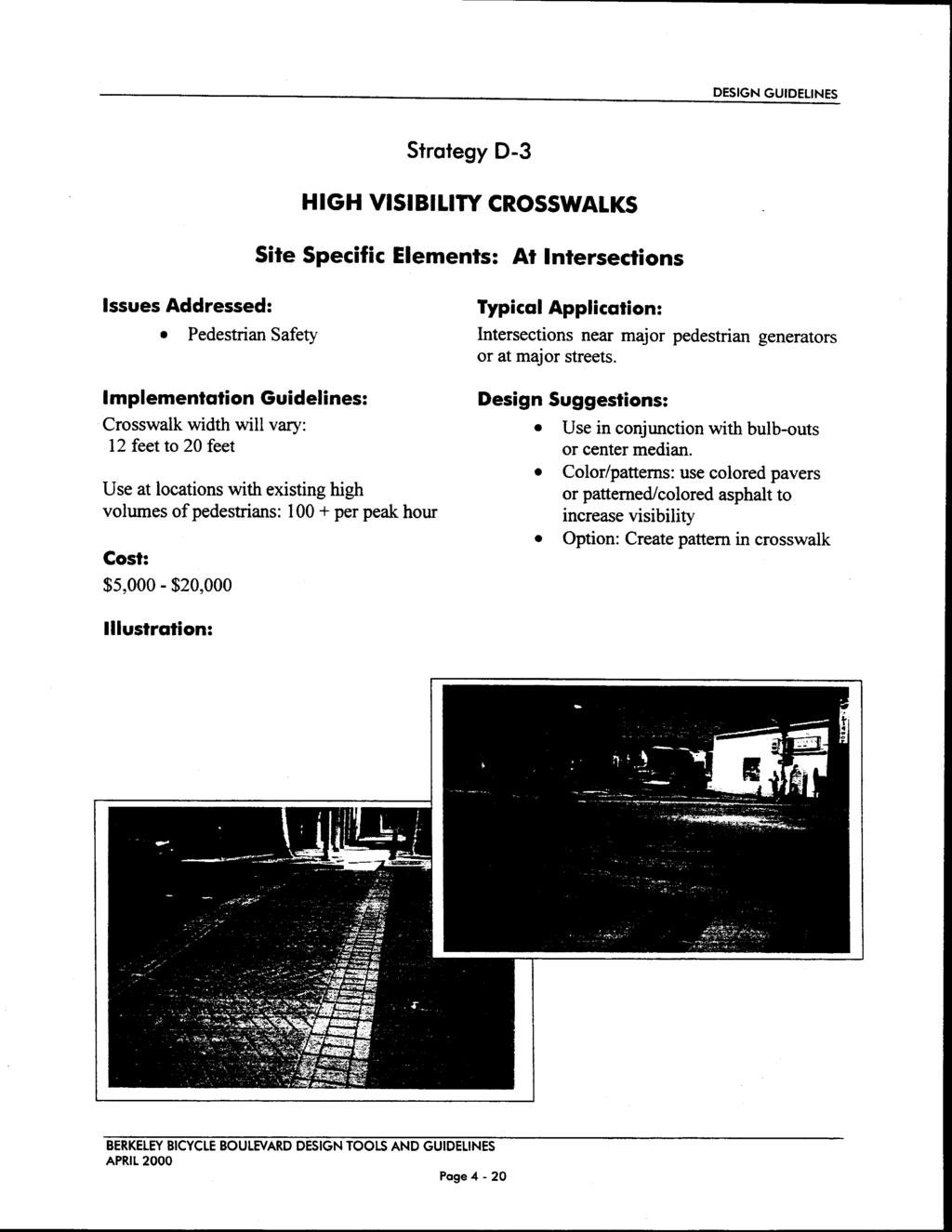
2 TOOLBOX AND SAMPLE BIKE BLVD LAYOUT Landscaping/street trees The second category is called Site Specific Tools. These would only be used to address a site specific issue. Which specific tool to be used would be determined in collaboration with local residents. Examples of site specific tools are: Traffic circles Bulbouts Traffic signals High-visibility crosswalks A summary of the toolbox is presented in Table 4-2. The entire toolbox presenting guidelines for applying each individual tool is presented at the end of this chapter. It should be noted that these tools are not meant to be used individually. The concept is to combine several tools so that the cumulative effect will create a look and feel that will tell both motorists and bicyclists that this street is special: it is not a speedway, but rather a place where people live and where many people ride their bikes. Figures 9 through 13 illustrate several possible ways to combine these tools on streets of different widths, some with existing bike lanes and some without. These drawings are not meant to represent any street in particular, but rather to show the cumulative effect of combining several strategies. A sample layout of several blocks is presented in Appendix A to illustrate conceptually how the various strategies can be combined to create a bicycle boulevard. Again, this layout is meant to be illustrative and does not present specific recommendations for a specific location. BERKELEY BICYCLE BOULEVARD DESIGN TOOLS AND GUIDELINES APRIL 2000 Page 4-2
3
4
5
6
7
8
9 TOOLBOX AND SAMPLE BIKE BLVD LAYOUT Table 4-2 TOOLBOX SUMMARY BASIC TOOLS (recommended for all bike boulevards) A. Signage 1. Identity signs 2. Special street sign design - at all intersections 3. Special advance street sign design at major streets 4. Continuous signage along Bicycle Blvd 5. Other signs to be used as needed for site-specific applications B. Throughout the Street 1. Visually dramatic markings 2. Unique Pavement Treatment for roadway or lanes 3. Planter Strip Landscaping/Street Trees 4. Bicycle Boulevard Pavement Legend SITE SPECIFIC TOOLS (to be used only where needed and in consultation with local residents) C. Midblock 1. High Visibility Crosswalks 2. Bulb-Outs midblock 3. One lane slow point 4. Mid-block median islands 5. Lightly patterned pavement surface D. At Intersections 1. Traffic Circles 2. Bulb-Outs at Intersections 3. High Visibility crosswalks 4. Special design/logo within intersections 5. Redesign existing diverters to be bike and emergency vehicle accessible E. To Enable or Help Bicyclists Cross Collectors or High Traffic Streets 1. Four-way STOP sign 2. Median refuge on major street 3. Traffic Signal - with turn restrictions for motor vehicles 4. Traffic Signal - with detection for bikes only 5. Traffic Signal - standard design BERKELEY BICYCLE BOULEVARD DESIGN TOOLS AND GUIDELINES APRIL 2000 Page 4-3
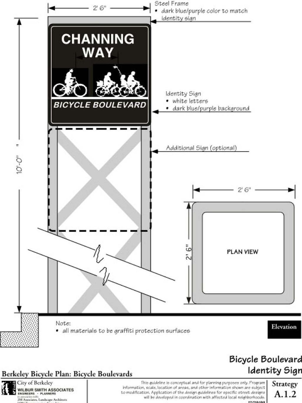
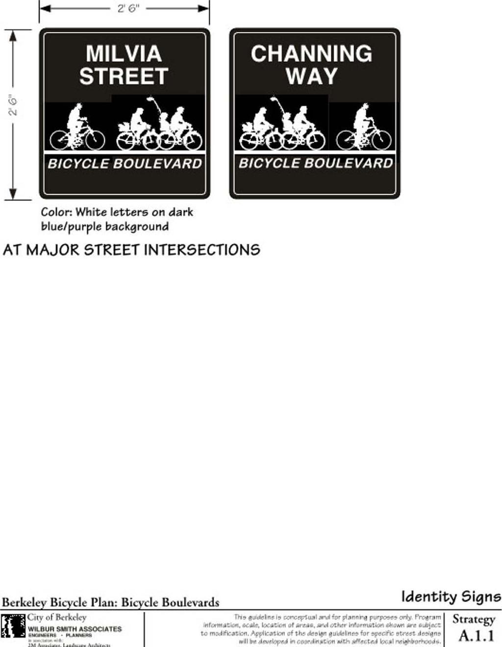
10 DESIGN GUIDELINES Strategy A-1 IDENTITY SIGNAGE Basic Element: Signage Issues Addressed: Look and Feel Typical Application: All bicycle boulevards to inform all roadway users that the street they are on is a bicycle boulevard. Implementation Guidelines: At major street crossings: Install sign on bike boulevard at intersections with major streets Design Suggestions: Blue/purple color Retro-reflective Graffiti proof Cost: $ 200 for sign and sign structure $50 for sign only Illustration: See facing and following pages for typical sketches. BERKELEY BICYCLE BOULEVARD DESIGN TOOLS AND GUIDELINES APRIL 2000 Page 4-4
11
12
13 DESIGN GUIDELINES Strategy A-2 SPECIAL STREET SIGN DESIGN Basic Element: Signage Issues Addressed: Look and Feel Typical Application: At all intersections along bicycle boulevard Implementation Guidelines: Corner street signs: every corner: 6 X 28 Replaces existing signs. Design Suggestions: Blue/purple color Retro-reflective Graffiti proof Cost: $150 - new sign and pole $50 - new sign installed on existing pole Illustration: See following page for typical sketches. BERKELEY BICYCLE BOULEVARD DESIGN TOOLS AND GUIDELINES APRIL 2000 Page 4-5
14
15 DESIGN GUIDELINES Strategy A-3 SPECIAL ADVANCE STREET SIGN DESIGN AT MAJOR STREETS Basic Element: Signage Issues Addressed: Look and Feel Typical Application: At bicycle boulevard intersections with major streets Implementation Guidelines: Advance signs: install on major streets 10 X 48 Replaces existing signs Design Suggestions: Blue/purple color Retro-reflective Graffiti proof Cost: $150 - new sign and pole $50 - new sign installed on existing pole Illustration: See facing page for typical sketches. BERKELEY BICYCLE BOULEVARD DESIGN TOOLS AND GUIDELINES APRIL 2000 Page 4-6
16 DESIGN GUIDELINES Strategy A-4 MIDBLOCK SIGNS ALONG BICYCLE BOULEVARD Basic Element: Signage Issues Addressed: Look and Feel Typical Application: All bicycle boulevards at midblock Implementation Guidelines: Midblock information signs (A.4.1): install as needed to direct cyclists to major destination. Midblock safety signs (A.4.2): alternate Share the Road and Slow signs so that each sign is installed every other block. Design Suggestions: Both: Retro-reflective Graffiti proof Information signs (A.4.1): blue/purple (Actual color to be selected in conjunction with the Bicycle Subcommittee, the goal of the specific color choice will be to have a distinctive color that will not be confused with other standard sign colors.) Safety signs (A.4.2): fluorescent yellow-green (Note: - final design of the A.4.2 Share the Road Sign to be determined in conjunction with the Bicycle Subcommittee prior to installation). Cost: $150 - new sign and pole $50 - new sign installed on existing pole Illustration: See facing page for typical sketches. BERKELEY BICYCLE BOULEVARD DESIGN TOOLS AND GUIDELINES APRIL 2000 Page 4-7
17
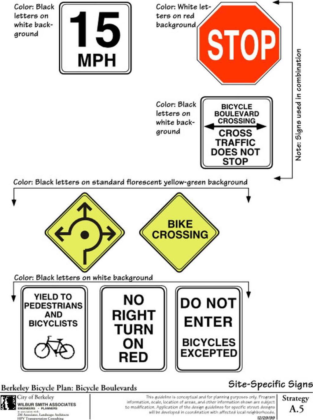
18 DESIGN GUIDELINES Strategy A-5 SITE SPECIFIC SIGNS Basic Element: Signage Issues Addressed: Look and Feel Typical Application: All bicycle boulevards as needed Implementation Guidelines: 15 MPH- install in school zones; Bicycle Boulevard: Cross Traffic Does Not Stop: install for side street traffic where stop signs are removed on the bicycle boulevard; Traffic Circle warning sign- install in advance of traffic circles; YIELD to Pedestrians and Bicyclists install where appropriate such as midblock crossings, channelized right turn lanes, etc. No Right Turn on Red- install where moderate to heavy right-turn volumes conflict with the safety of pedestrians and bicyclists; Do Not Enter Bicycles Excepted- install on diverters and other locations where motor vehicle traffic is prohibited. Design Suggestions: All: Retro-reflective Graffiti proof Color -as indicated in sketch Size in accordance with the Caltrans Traffic Manual and as specified by the City Traffic Engineer Cost: $150 - new sign and pole $50 - new sign installed on existing pole Illustration: See facing page for typical sketches. BERKELEY BICYCLE BOULEVARD DESIGN TOOLS AND GUIDELINES APRIL 2000 Page 4-8
19
20 DESIGN GUIDELINES Strategy B-1 VISUALLY DRAMATIC MARKINGS Basic Element: Lane Striping & Width Issues Addressed: Look and Feel Traffic Calming Implementation Guidelines: Narrow travel lanes: Stripe a travel lane of 9 or 10 feet. Use where centerline is striped, generally where ADTs > 2,000 VPD and one of the following is also present: Sections with Bike Lanes Commercial Areas School Zones Parking lane stripe all parking lane lines Description: This strategy includes both the design of the stripe (color, size and pattern) as well as where stripes are placed to narrow the width of a travel lane or parking lane. Typical Application: Narrow travel lanes (10 feet or less) (only applicable on sections with centerlines): generally where ADTs > 2,000 VPD Parking lane striping: roadways with onstreet parking Design Suggestions: Center Line Stripe: Standard Yellow 4 inch Parking Lane Stripe: 12 wide placed 7 feet from curb face Bike Lane Stripe: 6 inch white Marking materials: Type 1 tape or thermoplastic (with 10 % crushed glass to increase co-efficient of friction) Cost: Type 1 tape: $1.50 per linear foot-4 inch stripe $4.50 per linear foot 12 inch stripe Thermoplastic: $0.65 per linear foot-4 inch stripe $1.00 per linear foot 12 inch stripe BERKELEY BICYCLE BOULEVARD DESIGN TOOLS AND GUIDELINES APRIL 2000 Page 4-9
21
22
23
24 DESIGN GUIDELINES Strategy B-4 PAVEMENT LEGENDS Basic Element: Throughout the Street Issues Addressed: Look and Feel Traffic Calming Implementation Guidelines: With on-street parking: place 12 feet from curb face (measured to center of legend) Without on-street parking: place in center of travel lane. Place at beginning of block and midblock approx. 200 feet from first legend on the block. Typical Application: Bicycle boulevard sections without bike lanes Design Suggestions: Color: white legend Material: Type I tape, preferred Typical vendor: 3M Alternate material: thermoplastic modified with 10 % crushed glass to increase coefficient of friction. Cost: Type 1 tape: $500 each Thermoplastic: $150 each Illustration: See facing page for typical sketch. BERKELEY BICYCLE BOULEVARD DESIGN TOOLS AND GUIDELINES APRIL 2000 Page 4-13


25 75.5" 40" 53" 40" 139" 363.5" (30' 3.5") 72"
26
27
28
29
30
31
32 DESIGN GUIDELINES Strategy D-1 TRAFFIC CIRCLES Site Specific Elements: At Intersections Issues Addressed: Look and Feel Traffic Calming Pedestrian Safety Implementation Guidelines: Use in consultation with local residents when STOP signs are removed on the bicycle boulevard. Use at consecutive intersections will improve the traffic calming effect. Place where unwarranted four -way STOP signs are removed. Place where neighborhood supports additional traffic calming. Typical Application: At intersections on bicycle boulevards with less than 2000 vehicles per day; and where bicycle boulevard traffic currently has STOP sign. At intersections with minor streets: place STOP sign on minor street only (D.1.1) At intersection of two bicycle boulevards: all traffic yields (D.1.2) Design Suggestions: Splitter islands on approaches Landscaping or patterned pavement to add visual interest Landscaping less than two feet in height or canopy above eight feet. Maintain adequate curb to curb width for emergency vehicles through the use of aprons/alternative pavement materials on edge of traffic circle. Cost: $20,000 Illustration: See facing and following pages for typical sketches. BERKELEY BICYCLE BOULEVARD DESIGN TOOLS AND GUIDELINES APRIL 2000 Page 4-18
33 1'-0" 18'-0" Sign pole Architectural bollards with reflective band Note: Street dimensions vary 36.0 ' Elevation Change in pavement grade, color, and texture (could be rumble strip, cobblestone, or other material) Curb Low-maintenance landscape (rocks / shrubs) Broad canopy tree - placement based on location of underground utilities Bicycle Boulevard Architectural concrete bollards Safety sign Visually patterned or integral colored pavement Bicycle boulevard identity sign Yellow safety stripe w/ raised reflector markers STOP Bike Boulevard crossing sign Plan Berkeley Bicycle Plan: Bicycle Boulevards City of Berkeley WILBUR SMITH ASSOCIATES ENGINEERS PLANNERS in association with: 2M Associates, Landscape Architects HPV Transportation Consulting Intersection of Bicycle Boulevard and Minor Street This guideline is conceptual and for planning purposes only. Program information, scale, location of areas, and other information shown are subject to modification. Application of the design guidelines for specific street designs will be developed in coordination with affected local neighborhoods. 12/29/99 Strategy D.1.1
34 1'-0" 18'-0" Sign pole Architectural bollards with reflective band Note: Street dimensions vary 36'-0" Elevation Change in pavement grade, color, and texture (could be rumble strip, cobblestone, or other material) Curb Low-maintenance landscape (rocks / shrubs) Broad canopy tree - placement based on location of underground utilities Bicycle Boulevard Architectural concrete bollards Safety sign Visually patterned or integral colored pavement Bicycle boulevard identity sign Yellow safety stripe w/ raised reflector markers YIELD Plan Berkeley Bicycle Plan: Bicycle Boulevards City of Berkeley WILBUR SMITH ASSOCIATES ENGINEERS PLANNERS in association with: 2M Associates, Landscape Architects HPV Transportation Consulting Intersection of Two Bicycle Boulevards This guideline is conceptual and for planning purposes only. Program information, scale, location of areas, and other information shown are subject to modification. Application of the design guidelines for specific street designs will be developed in coordination with affected local neighborhoods. 12/29/99 Strategy D.1.2
35
36
37 36'-0" Note: Street dimensions vary Broad canopy tree - adjust based on location of underground utilities Patterned or integral colored pavement Bicycle Boulevard Crosswalk (where appropriate) STOP Bike Boulevard crossing sign Berkeley Bicycle Plan: Bicycle Boulevards City of Berkeley WILBUR SMITH ASSOCIATES ENGINEERS PLANNERS in association with: 2M Associates, Landscape Architects HPV Transportation Consulting Bulb-Out: Bicycle Boulevard Intersection This guideline is conceptual and for planning purposes only. Program information, scale, location of areas, and other information shown are subject to modification. Application of the design guidelines for specific street designs will be developed in coordination with affected local neighborhoods. 12/29/99 Plan Strategy D.2 D.4
38
39
40
41
42
43
44
45
46
Broad Street Bicycle Boulevard Design Guidelines
 Broad Street Bicycle Boulevard Design Guidelines Building from the strategies introduced in the 2013 Bicycle Transportation Plan and community input received thus far, City Transportation Staff have identified
Appendix C. TRAFFIC CALMING PROGRAM TOOLBOX
 Appendix C. TRAFFIC CALMING PROGRAM TOOLBOX PHASE I...2 Do Not Enter Sign...3 One-Way Sign...4 Turn Prohibition...5 Pavement Markings...6 Speed Monitoring Trailer...7 Neighborhood Speed Watch...8 Police
Town of Mooresville, North Carolina Neighborhood Traffic Calming and Control Device Policy
 Town of Mooresville, North Carolina Neighborhood Traffic Calming and Control Device Policy Adopted January 6, 2014 Town of Mooresville Development Services Department TOWN OF MOORESVILLE NEIGHBORHOOD TRAFFIC
City of Vallejo Traffic Calming Toolbox
 City of Vallejo Traffic Calming Toolbox June 1, 2013 Final Table of Contents Introduction... 1 Non-Physical Devices... 3 High-Visibility Crosswalk... 3 In Pavement Lighted Crosswalk... 4 Rapid Flashing
Cycle Track Design Best Practices Cycle Track Sections
 Design Best Practices Sections It is along street segments where the separation and protection methods of cycle tracks offer more comfort than conventional bicycle lanes, and are more attractive to a wide
Transportation Planning Division
 Transportation Planning Division Presentation Outline Study Tasks Recap of Previous Meetings Data Collected Focus Areas within Study Limits Design Principles Tool Box Recommended Concepts Schedule Moving
Appendix A. Knoxville TPO Greenway Signage Guidelines. Appendix A: Knoxville TPO Greenway Signage Guidelines Knox to Oak Ridge Greenway Master Plan
 Appendix A Knoxville TPO Greenway Signage Guidelines 75 Overview: Adequate signing and marking are essential on shared-use paths, especially to alert bicyclists to potential conflicts and to convey regulatory
TRAFFIC CALMING GUIDE FOR TORONTO CITY OF TORONTO TRANSPORTATION SERVICES DIVISION
 TRAFFIC CALMING GUIDE FOR TORONTO CITY OF TORONTO TRANSPORTATION SERVICES DIVISION CITY OF TORONTO TRANSPORTATION SERVICES DIVISION 2016 TRAFFIC CALMING GUIDE FOR TORONTO TABLE OF CONTENTS Introduction
Bicycle Facilities Planning
 Bicycle Facilities Planning Overview Types of Cyclists Purpose for Riding Types of Facilities Bike Lanes Bicycle Boulevards Cycle Tracks Intersections Signals Signing and Marking Discussion Types of Bicyclists
County of Greenville South Carolina. Traffic Calming Program Neighborhood Traffic Education Program and Speed Hump Program
 County of Greenville South Carolina Traffic Calming Program Neighborhood Traffic Education Program and Speed Hump Program (rev) August 2008 I. PURPOSE The potential negative impacts from vehicular traffic
MARTIN LUTHER KING JR. WAY
 OCTOBER 2011 40 Vision and Goals The Martin Luther King, Jr. Way Illustrative Master Plan that follows has been developed through a process of community involvement. It expresses a long term vision for
Appendix T CCMP TRAIL TRAFFIC & TRANSPORTATION DESIGN STANDARD
 Appendix T CCMP 3.3.4 TRAIL TRAFFIC & TRANSPORTATION DESIGN STANDARD 3.3.4 Trail Traffic and Transportation Design Multi-use trails have certain design standards, which vary depending on the agency that
APPENDIX A: Complete Streets Checklist DRAFT NOVEMBER 2016
 APPENDIX A: Complete Streets Checklist DRAFT NOVEMBER 2016 Complete Streets Checklist MetroPlan Orlando s Complete Streets Checklist is an internal planning tool for staff to further implementation of
Traffic Calming SECTION 1, CHAPTER Introduction What is Traffic Calming?
 SECTION 1, CHAPTER 6 Traffic Calming 6.1 Introduction 6.1.1 What is Traffic Calming? Traffic calming deals with neighborhood traffic issues comprehensively using the three E s, Education, Enforcement,
TRAFFIC CALMING TOOLBOX
 TRAFFIC CALMING TOOLBOX Traffic control devices are those official signs and striping placed in the public right-of-way and recognized by the public such as STOP signs, curve warning signs, centerline
Gateway Signs. Description: Sign reminding drivers of the need to drive slowly Issues addressed: speeding Cautions/Limitations: Application:
 Level 1 Limited Application Gateway Signs Description: Sign reminding drivers of the need to drive slowly Issues addressed: speeding Increased motorist awareness of the neighborhood character Provides
MEMORANDUM. Date: 9/13/2016. Citywide Crosswalk Policy
 MEMORANDUM Date: 9/13/2016 Re: Citywide Crosswalk Policy Foreword Through the s Circulation Element and Complete Streets Policy, it is the City s goal to promote walking trips and provide safe facilities
CURBSIDE ACTIVITY DESIGN
 5 CURBSIDE ACTIVITY DESIGN This chapter provides design guidance for separated bike lanes adjacent to curbside activities including parking, loading and bus stops. Typical configurations are presented
Victoria Park Master Plan
 Victoria Park Master Plan Phase I Presented By: ARCHITECTURAL ALLIANCE & HUGHES HUGHES INC. History of Victoria Park Phase I Purpose Inventory of Existing Conditions Identification of Options by Type (for
Zlatko Krstulich, P.Eng. City of O9awa
 Zlatko Krstulich, P.Eng. City of O9awa 1. Introduction to the Ontario Traffic Manual Series 2. What is OTM Book 18: Bicycle Facilities? 3. Study / Committee Team Members 4. Brief overview of the content
Design Guidelines. Overview. Design Vision for Yellow Brick Road
 Design Guidelines Overview This section presents the design vision for the Yellow Brick Road network. The Yellow Brick Road is envisioned to be an interconnected network of safe and secure roadways where
DRAFT - CITY OF MEDFORD TRANSPORTATION SYSTEM PLAN Roadway Cross-Sections
 Roadway Cross-Sections Medford s roadway cross-section standards apply to new and reconstructed roads. The crosssections take into consideration roadway function and operational characteristics, including
City of Margate, Florida. Neighborhood Traffic Management Manual
 City of Margate, Florida Neighborhood Traffic Management Manual Table of Contents Page No. I. INTRODUCTION... 1 II. TRAFFIC CALMING REQUEST AND PROCESSING PROCEDURES... 2 1. COMPLETE AND SUBMIT PROJECT
El Camino Real Specific Plan. TAC/CAC Meeting #2 Aug 1, 2018
 El Camino Real Specific Plan TAC/CAC Meeting #2 Aug 1, 2018 Land Use Alternatives Goals and Tradeoffs Parks & open space Housing Retail & services Civic spaces Parking Community gathering spaces 3 Alternatives
Retrofitting Urban Arterials into Complete Streets
 Retrofitting Urban Arterials into Complete Streets John N. LaPlante, P.E., P.T.O.E., T.Y. Lin International Prepared for: Illinois Traffic Engineering & Safety Conference Urbana, Illinois October 18, 2007
TRAFFIC CALMING PLANNER S PORTFOLIO
 TRAFFIC CALMING PLANNER S PORTFOLIO ISSUE 8 January 2017 PLANNER S PORTFOLIO TRAFFIC CALMING 1 OVERVIEW 2 3 4 ENGINEERED TRAFFIC CALMING MEASURES SIGNS AND PAVEMENT MARKINGS EMERGENCY RESPONSE DELAYS 5
Appendix A: Crosswalk Policy
 Appendix A: Crosswalk Policy Appendix A: Crosswalk Policy Introduction This citywide Crosswalk Policy is aimed at improving pedestrian safety and enhancing pedestrian mobility by providing a framework
Residential Traffic Calming Program Guide. Town of Ashland, Virginia
 Residential Traffic Calming Program Guide Town of Ashland, Virginia August 1, 2006 TABLE OF CONTENTS A. INTRODUCTION... 1 B. GOALS... 1 C. CRITERIA... 1 D. IDENTIFYING NEIGHBORHOOD TRAFFIC CONCERNS...
3.1 TRAFFIC CALMING PROCESS SUMMARY
 SECTION 3 3.0 TRAFFIC CALMING 3.1 TRAFFIC CALMING PROCESS SUMMARY Traffic calming is a means in which to reduce speeds and minimize vehicular traffic on local neighborhood streets. Citizen involvement
Ocean Park Boulevard Green Street Project Alternatives & Trade Offs
 Planning Commission March 4, 2009 Ocean Park Boulevard Green Street Project Alternatives & Trade Offs Purpose of Tonight s Meeting Review concept plans and options Provide input on alternatives and trade-offs
Closing Plenary Session
 TRAFFIC SAFETY CONFERENCE Closing Plenary Session June 9, 2017 Las Colinas, TX Order of Report Out June 9, 2017 Las Colinas, TX Distracted Driving Prioritized Countermeasures Countermeasure 4a Systemically
New Construction - Transportation Guide
 New Construction - Transportation Guide Traffic Calming Measures DATE: August 21, 2014 PURPOSE: To identify traffic calming measures for roadways that are compatible with the emergency response needs and
CHAPTER 1 STANDARD PRACTICES
 CHAPTER 1 STANDARD PRACTICES OBJECTIVES 1) Functions and Limitations 2) Standardization of Application 3) Materials 4) Colors 5) Widths and Patterns of Longitudinal Pavement Marking Lines 6) General Principles
City of Elizabeth City Neighborhood Traffic Calming Policy and Guidelines
 City of Elizabeth City Neighborhood Traffic Calming Policy and Guidelines I. Purpose: The City of Elizabeth City is committed to ensure the overall safety and livability of residential neighborhoods. One
DEPARTMENT OF ENVIRONMENTAL SERVICES. North Harrison Street (Lee Highway to Little Falls Road) Comparative Analysis. Prepared for:
 Comparative Analysis. Prepared for:") DEPARTMENT OF ENVIRONMENTAL SERVICES North Harrison Street (Lee Highway to Little Falls Road) Comparative Analysis Prepared for: Arlington County Department of Environmental Services 2100 Clarendon Boulevard,
DEPARTMENT OF ENVIRONMENTAL SERVICES North Harrison Street (Lee Highway to Little Falls Road) Comparative Analysis Prepared for: Arlington County Department of Environmental Services 2100 Clarendon Boulevard,
SAGINAW CHARTER TOWNSHIP - NEIGHBORHOOD TRAFFIC CALMING PROGRAM
 SAGINAW CHARTER TOWNSHIP - NEIGHBORHOOD TRAFFIC CALMING PROGRAM Section 1.0 Statement of Purpose Traffic conditions on residential streets can greatly affect neighborhood livability. When streets are safe
C. Best Practice Pedestrian Treatment Toolbox
 C. Best Practice Pedestrian Toolbox The Best Practice Pedestrian Toolbox presents the recommended tools in striping, signalization, signage, geometry and other categories for improving both uncontrolled
NEIGHBORHOOD TRAFFIC CALMING POLICY
 NEIGHBORHOOD TRAFFIC CALMING POLICY Traffic Calming is the combination of physical measures that reduce the negative effects of motor vehicle use, alter driver behavior and improve conditions for both
UPTOWN REGIONAL BIKE CORRIDORS PROJECT SAN DIEGO ASSOCIATION OF GOVERNMENTS
 UPTOWN REGIONAL BIKE CORRIDORS PROJECT SAN DIEGO ASSOCIATION OF GOVERNMENTS SUMMARY REPORT: COMMUNITY UPDATE MEETING February 6, 2014 6 8:30 p.m. Roosevelt Middle School Library 3366 Park Blvd, San Diego
City of Vestavia Hills Traffic Calming Policy for Residential Streets
 City of Vestavia Hills Traffic Calming Policy for Residential Streets PURPOSE: The purpose of the Traffic Calming Policy for Residential Streets is to address safety concerns related to vehicular traffic
UDC Street Cross Sections
 UDC Street Cross Sections Local Street - Downtown Local Street Mountable Curb Local Street Vertical Curb Alley Major Arterial Minor Arterial Residential Lane Residential Collector Residential Collector
TRAFFIC CALMING TOOLBOX. For the residents of the City of Decatur, Georgia
 TRAFFIC CALMING TOOLBOX For the residents of the City of Decatur, Georgia 2 City of Decatur Traffic Calming Toolbox Public Works Department 2635 Talley Street Decatur, GA 30030 404.377.5571 3 Welcome to
Report. Typical Sections. City of Middleton, WI
 Report Typical Sections City of Middleton, WI December 2006 Report for City of Middleton, Wisconsin Typical Sections repared by: Traffic Associates LLC and STRAND ASSOCIATES, INC. 910 West Wingra Drive
PEDESTRIAN ACCOMMODATIONS DPS 201 AT ROUNDABOUTS
 PEDESTRIAN ACCOMMODATIONS DPS 201 AT ROUNDABOUTS WHY THEY WORK FOR PEDESTRIANS IF DESIGNED CORRECTLY Separated sidewalks direct peds to crosswalks Splitter island Slow speed exit Truck apron Crosswalk
City of Charlottesville Traffic Calming Handbook
 City of Charlottesville Traffic Calming Handbook July 2008 CITY OF CHARLOTTESVILLE NEIGHBORHOOD DEVELOPMENT SERVICES Telephone: (434)970-3182 Fax: (434) 970-3359 Introduction The City of Charlottesville
City of Port St. Lucie Neighborhood Traffic Calming Policy City of Port St. Lucie Neighborhood Traffic Calming Policy Adopted June 26, 2017
 City of Port St. Lucie Neighborhood Traffic Calming Policy Adopted June 26, 2017 INTRODUCTION The City of Port St. Lucie is committed to ensuring the overall safety and livability of residential neighborhoods.
Traffic Calming Policy Manual
 Traffic Calming Policy Manual What is Traffic Calming? Speeding and unsafe driving habits are a major concern throughout communities in the United States. The Town of Summerville is no exception with neighborhoods
Chapter 2: Standards for Access, Non-Motorized, and Transit
 Standards for Access, Non-Motorized, and Transit Chapter 2: Standards for Access, Non-Motorized, and Transit The Washtenaw County Access Management Plan was developed based on the analysis of existing
PEDESTRIAN CIRCULATION & STREETSCAPE DESIGN
 CHAPTER 4 Chapter 4 Pedestrian Circulation & Trails PEDESTRIAN CIRCULATION & STREETSCAPE DESIGN In recent years, the City has constructed new sidewalks and enhanced existing ones in the downtown with brick
Draft Traffic Calming Policy Paper
 Draft Traffic Calming Policy Paper What is Traffic Calming The term traffic calming is defined differently throughout the United States. The Institute of Transportation Engineers, an international educational
Bicycle Boulevards and Neighborhood Greenways
 Bicycle Boulevards and Neighborhood Greenways Traffic Safety is Improving for Everyone 90 80 70 60 50 40 30 20 10 0 PORTLAND: TOTAL TRAFFIC FATALITIES 1986-2008 1986 1987 1988 1989 1990 1991 1992 1993
STEERING COMMITTEE MEETING June 17, Streetscape Overview Burlington Comprehensive Master Plan
 STEERING COMMITTEE MEETING June 17, 2015 Streetscape Overview Burlington Comprehensive Master Plan 1 Introduction Slide This slide show was presented to the Burlington Steering Committee on June 17, 2015
West Broad Street Traffic Study
 West Broad Street Traffic Study Prepared for the Town of Plainville by Central Connecticut Regional Planning Agency (CCRPA) October 2011 Central Connecticut Regional Planning Agency 225 N. Main St. Suite
DRAFT FOR DISCUSSION PURPOSED ONLY, 10/26/13 MOBILITY PLAN UPDATE DESIGN TOOLBOX
 DRAFT FOR DISCUSSION PURPOSED ONLY, 10/26/13 MOBILITY PLAN UPDATE DESIGN TOOLBOX Tool #1: Bike Lane Portion of the roadway designated for preferential use by bicyclists. One-way facilities that typically
Military Road Safety Improvements
 Military Road Safety Improvements 26 th Road North to 31 st Street North SUMMARY OF DATA REVIEW AND PRELIMINARY RECOMMENDATIONS Prepared for: Department of Environmental Services Traffic Engineering and
DRAFT. A fifth objective, other considerations, has been added to capture considerations not captured by the four primary objectives.
 TECHNICAL MEMORANDUM Albany - Washington Avenue Traffic Calming Evaluation Matrix of Conceptual Alternatives Date: May 17, 2017 Project #: 17356 To: Aleida Andrino-Chavez From: Laurence Lewis, Sara Muse,
The Wiggle Route in Context
 The Wiggle Route in Context In a city of hills, the Wiggle is an important route because it winds its way along the flattest streets from Market to the Panhandle, bringing residents to local parks and
By: Bill Baranowski, PE TRAFFIC CALMING EXAMPLES IN SUGARHOUSE, DAYBREAK, AND WEST JORDAN CITY
 By: Bill Baranowski, PE TRAFFIC CALMING EXAMPLES IN SUGARHOUSE, DAYBREAK, AND WEST JORDAN CITY 1977 HIGHLAND RUGBY TOUR 1945 WHERE??? What is more contentious than traffic calming? 1951 LOOKING SOUTHEAST
Active Transportation Facility Glossary
 Active Transportation Facility Glossary This document defines different active transportation facilities and suggests appropriate corridor types. Click on a facility type to jump to its definition. Bike
Observations and Ideas: Toomer s Corner Streetscape Improvements
 Observations and Ideas: Toomer s Corner Streetscape Improvements AUBURN DOWNTOWN MASTER PLAN planning downtown s future August 26, 2013 Observations: Vertical Clutter at Corners 6 3 7 5 9 2 8 4 1 Excess
Neighborhood Traffic Calming Guidelines
 Neighborhood Traffic Calming Guidelines ADOPTED BY THE CITY COUNCIL OF ARROYO GRANDE BY RESOLUTION NO. 2016-4718 ON APRIL 12, 2016 COMMUNITY DEVELOPMENT DEPARTMENT ENGINEERING DIVISION 300 East Branch
March 2008 FINAL DRAFT. Supplemental Bikeway Design Guidelines
 March 2008 FINAL DRAFT Supplemental Bikeway Design Guidelines Prepared for: Marin County Department of Public Works Marin County Unincorporated Area Bicycle and Pedestrian Master Plan Prepared by: Alta
Watertown Complete Streets Prioritization Plan. Public Meeting #1 December 14, 2017
 Watertown Complete Streets Prioritization Plan Public Meeting #1 December 14, 2017 Goals for Public Meeting Overview of MassDOT Complete Streets Funding Program Educate the community on Complete Streets
Acknowledgements. Mr. David Nicol 3/23/2012. Daniel Camacho, P.E. Highway Engineer Federal Highway Administration Puerto Rico Division
 Daniel Camacho, P.E. Highway Engineer Federal Highway Administration Puerto Rico Division Acknowledgements Mr. David Nicol Director, FHWA Office of Safety FHWA Office of Safety http://safety.fhwa.dot.gov/provencountermeasures/
Appendix 3 Roadway and Bike/Ped Design Standards
 Appendix 3 Roadway and Bike/Ped Design Standards OTO Transportation Plan 2040 4/20/2017 Page A3-1 Adopted Standards The adopted OTO Design Standards and Major Thoroughfare Plan are contained herein.
IMPROVING PEDESTRIAN SAFETY AT UNCONTROLLED CROSSINGS. Guidelines for Marked Crosswalks
 IMPROVING PEDESTRIAN SAFETY AT UNCONTROLLED CROSSINGS Presented by Nazir Lalani P.E. Traffex Engineers Inc. N_lalani@hotmail.com Guidelines for Marked Crosswalks Source: FHWA, Safety Effects of Marked
RESIDENTIAL TRAFFIC CALMING PROGRAM
 RESIDENTIAL TRAFFIC CALMING PROGRAM CITY OF ALEXANDRIA, KENTUCKY Prepared For: Safety & Public Works Departments 1 Table of Contents CITY OF ALEXANDRIA... 3 RESIDENTIAL TRAFFIC CALMING PROGRAM... 3 INTRODUCTION...
Dr. M.L. King, Jr. Street North Complete Streets Resurfacing Opportunities HOUSING, LAND USE, AND TRANSPORTATION COMMITTEE MARCH 22, 2018
 Dr. M.L. King, Jr. Street North Complete Streets Resurfacing Opportunities HOUSING, LAND USE, AND TRANSPORTATION COMMITTEE MARCH 22, 2018 What s Happening The City plans to mill and resurface Dr. M.L.
Community Transportation Plan
 Community Transportation Plan Appendix A: Traffic Calming CITY OF DECATUR COMMUNITY TRANSPORTATION PLAN Appendix A: City of Decatur City-wide Residential Traffic Calming Program Process & Procedures The
THE ALAMEDA CONCEPT DESIGN COMMUNITY MEETING 3. A Plan for The Beautiful Way JANUARY 28, 2010
 CONCEPT DESIGN COMMUNITY MEETING 3 JANUARY 28, 2010 AGENDA INTRODUCTION COMMUNITY INPUT ROADWAY STUDIES STREETSCAPE DESIGN STATIONS DISCUSSION SUMMARY AND DISCUSSION NEXT STEPS CLOSE INTRODUCTION SCHEDULE
9.1 FUNCTIONAL HIGHWAY SYSTEMS IN URBANIZED AREAS Principal Arterial Interstate Principal Arterial Non-Interstate
 Greater Bozeman Area Transportation Plan (2007 Update) Chapter 9: Recommended Major Street Network & Roadway Typical Sections 9.1 FUNCTIONAL HIGHWAY SYSTEMS IN URBANIZED AREAS The discussion in this Chapter
2018 AASHTO BIKE GUIDE
 2018 AASHTO BIKE GUIDE Your presenter Rob Burchfield, PE NW Regional Engineering Director 35 years of experience in traffic engineering and bicycle facility design Toole Design Group Toole Design Group
12/4/2016 VIA . RE: Grocery Outlet Del Paso (DR16-328)
") 12/4/2016 VIA EMAIL Ethan Meltzer, Assistant Planner City of Sacramento Community Development Department 300 Richards Blvd, 3 rd Floor Sacramento, CA 95811 RE: Grocery Outlet Del Paso (DR16-328) Dear Mr.
12/4/2016 VIA EMAIL Ethan Meltzer, Assistant Planner City of Sacramento Community Development Department 300 Richards Blvd, 3 rd Floor Sacramento, CA 95811 RE: Grocery Outlet Del Paso (DR16-328) Dear Mr.
Bicycle + Pedestrian Connectivity Gap Analysis
 Accelerated Bridge Program Bicycle + Pedestrian Connectivity Gap Analysis Tuesday, October 11 Shriners Hospital, Boston 6:30-8:00 PM Thursday, October 13 Community Rowing, Brighton 6:30-8:00 PM Tuesday,
Markings Technical Committee Chapter 3H: Roundabout Markings APPROVED IN NCUTCD COUNCIL ON JANUARY 20, 2006
 ATTACHMENT NO. 30 Markings Technical Committee Chapter 3H: Roundabout Markings APPROVED IN NCUTCD COUNCIL ON JANUARY 20, 2006 Roundabouts are becoming an increasingly utilized form of intersection design
CURB EXTENSIONS BULB OUTS DPS 201 NECKDOWNS
 CURB EXTENSIONS BULB OUTS DPS 201 NECKDOWNS WHY WHEN & WHERE When Limited Sight Distance Pedestrians & Vehicles Vehicles and Signs Want to put two curb ramps in Discourage High speed turning High number
This page intentionally left blank.
 This page intentionally left blank. COMMUNITY Coweta Community Overview Coweta Coweta, a residential community located in Wagoner County, is a suburb of Tulsa situated southeast of the metropolitan area
Ocean Park Boulevard Streetscape Improvement Project Alternatives & Trade Offs
 City Council Study Session January 27, 2009 Ocean Park Boulevard Streetscape Improvement Project Alternatives & Trade Offs Scope of Work Purpose of Tonight s Meeting Review work to date and direct staff
Neighborhood Pedestrian Safety and Traffic Calming Study
 Neighborhood Pedestrian Safety and Traffic Calming Study for the area bounded by Foster Avenue, Bedford Avenue, Farragut Road and Ocean Avenue Flatbush, Brooklyn, New York prepared by Michael King, miking@trafficcalmer.com
Agenda. Overview PRINCE GEORGE S PLAZA METRO AREA PEDESTRIAN PLAN
 PRINCE GEORGE S PLAZA METRO AREA PEDESTRIAN PLAN May 28, 2008 Agenda Welcome and introductions Project overview and issue identification Planning context and strengths Design challenges and initial recommendations
INTRODUCTION TO BICYCLE BOULEVARDS
 ROCHESTER, NY Chapter Contents: Introduction Benefits of Bicycle Boulevards Routing Selection Process Design Strategy Tools Marketing + Branding INTRODUCTION TO BICYCLE BOULEVARDS In an effort to appeal
TOWN OF PAYSON TRAFFIC CALMING MANUAL
 TOWN OF PAYSON TRAFFIC CALMING MANUAL APPROVED BY THE PAYSON TOWN COUNCIL SEPTEMBER 6, 2007 TOWN OF PAYSON TRAFFIC CALMING POLICY 1.0 Introduction Traffic Calming involves retrofitting physical devices
Glebe Neighbourhood Cycling Plan
 Glebe Neighbourhood Cycling Plan Summary of Public Comments received after June 5 th Public Information Session Comment STUDY NETWORK CS9, CS8, E, E0 CS4, E CS4 CS8 E Suggestions for alternate cycling
FEDERAL HIGHWAY ADMINISTRATION APPLICATION
 FEDERAL HIGHWAY ADMINISTRATION APPLICATION REQUEST FOR PERMISSION TO EXPERIMENT WITH A BICYCLE BOX INTERSECTION TREATMENT Submitted by: City of Columbus Department of Public Service Date: June 26, 2009
$ 12" $#&%$ 86.) *1! *1 /3 )00, , (1* Neighborhood Traffic Calming Part 3 Solutions Bradley William Yarger, P.E.
 *1! *1 /3 )00, , (1* Neighborhood Traffic Calming Part 3 Solutions Bradley William Yarger, P.E.") $ 12" $#&%$ 86.)3+5+2 714 *1! *1 /3 )00,12 3.+ -0127 1, (1* Neighborhood Traffic Calming Part 3 Solutions by Bradley William Yarger, P.E. It is extremely tempting to jump to this step of the process thinking
$ 12" $#&%$ 86.)3+5+2 714 *1! *1 /3 )00,12 3.+ -0127 1, (1* Neighborhood Traffic Calming Part 3 Solutions by Bradley William Yarger, P.E. It is extremely tempting to jump to this step of the process thinking
Alternative Traffic Calming Methods
 Alternative Traffic Calming Methods In-street Pedestrian Crossing Sign Cost: approximately $300 per sign not including the installation cost Advantages of in-street pedestrian crossing signs 1. Typically
Speed Feedback Radar Trailer
 Speed Feedback Radar Trailer Residents are encouraged to contact the El Cerrito Police Department s Traffic Safety Unit to request the deployment of the Speed Feedback Radar Trailer. The Radar Trailer
Chapter 3: Multi-Modal Circulation and Streetscapes
 CHAPTER 3: MULTI-MODAL CIRCULATION AND STREETSCAPES Chapter 3: Multi-Modal Circulation and Streetscapes Overview Streetscape improvements have already been completed for Depot Street between Main Avenue
Chapter 5: Crossing the Street
 Chapter 5: Crossing the Street Whether walking or bicycling, a student s journey to school will more than likely require crossing one or more streets. Per the Safe Routes to School Guide, maintained by
South Carolina Department of Transportation. Engineering Directive
 South Carolina Department of Transportation Engineering Directive Directive Number: ED-22 Effective: December 16, 2009 Subject: References: Purpose: This Directive Applies to: Considerations for Bicycle
DEPARTMENT OF PUBLIC WORKS Carroll County, Maryland
 DEPARTMENT OF PUBLIC WORKS Carroll County, Maryland Prepared by the Bureau of Engineering 225 North Center Street, Room 221, Westminster, MD 21157 (410) 386-2157 e-mail: trafficcalming@ccg.carr.org http://ccgovernment.carr.org/trafficcalming
Fundamentals of Traffic Control Devices
 Fundamentals of Traffic Control Devices Traffic Engineering & Operations October 8, 2014 Raj Ponnaluri, Angela Wilhelm, and Christopher Lewis Agenda Agenda Signs Pavement Markings Signals Traffic Operations
2009 Manual on Uniform Traffic Control Devices
 2009 Manual on Uniform Traffic Control Devices Tori Brinkly, PE Highway Safety Engineer WFL-FHWA April 20, 2010 Paragraphs are numbered. Standard Statements are bolded. Guidance statements are italicized.
Memo. Introduction. Memphis STP Pedestrian Sidewalk Project
 Memo Memphis STP Pedestrian Sidewalk Project To: Kyle Wagenshutz, City of Memphis From: Matthew Berkow, Collin Chesston, and Anne Eshleman, Alta Planning + Design Date: June 2014 Re: Photo Inventory Introduction
CITY OF SARATOGA SPRINGS PEDESTRIAN CROSSING TOOLBOX
 CITY OF SARATOGA SPRINGS PEDESTRIAN CROSSING TOOLBOX This toolbox is to be used to guide pedestrian crossing improvements within the City of Saratoga Springs. Details for each crossing type are provided.
Tonight is for you. Learn everything you can. Share all your ideas.
 Strathcona Neighbourhood Renewal Draft Concept Design Tonight is for you. Learn everything you can. Share all your ideas. What is Neighbourhood Renewal? Creating a design with you for your neighbourhood.
MINERAL AVENUE CORRIDOR ASSESSMENT STUDY IMPLEMENTATION STRATEGY
 MINERAL AVENUE CORRIDOR ASSESSMENT STUDY IMPLEMENTATION STRATEGY INTRODUCTION City Personnel Sign-in Sheet Comment Forms Please Write Down Any Feedback INTRODUCTION List of Topics for Presentation Study
Section 9A.07 Meaning of Standard, Guidance, Option, and Support
 2012 Edition Page 895 PART 9. TRAFFIC CONTROLS FOR BICYCLE FACILITIES CHAPTER 9A. GENERAL Section 9A.01 Requirements for Bicyclist Traffic Control Devices 01 General information and definitions concerning
5. RUNNINGWAY GUIDELINES
 5. RUNNINGWAY GUIDELINES These guidelines should be considered collectively when making runningway decisions. A runningway is the linear component of the transit system that forms the right-of-way reserved
Table of Contents Introduction...1. A. Background B. Introduction to Traffic Calming Devices Purpose Statement...
 Borough of Brentwood February 23, 2010 Neighborhood Traffic Calming FINAL Program Table of Contents Neighborhood Traffic Calming Program 192-01 Introduction...1 A. Background... 1 B. Introduction to Traffic